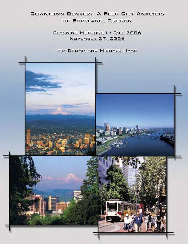
DOWNTOWN DENVER: A PEER CITY ANALYSIS OF PORTLAND, OREGON
|
|
|
- Mark Glenn
- 6 years ago
- Views:
Transcription
1
2 DOWNTOWN DENVER: A PEER CITY ANALYSIS OF PORTLAND, OREGON INTRODUCTION The purpose of this analysis is to compare the significant planning principals that are being employed within Downtown Portland, Oregon and compare them to the existing planning that is occurring within Downtown Denver. The comparison is meant to be a tool that will allow Denver planners to foresee potential problems or success that may be encountered when taking administrative action within the Downtown. The analysis starts with the broad characterization of the Downtown area and how it relates to the overall region. It then moves away from the general attributes of the area and focuses on issues, such as zoning, population distribution, and development. The analysis also focuses on parking and how it relates to the overall pedestrian environment within the Downtown area. The research for this analysis was compiled using literature searches and personal interviews with both business and governmental interests within Downtown Portland. Recommendations are based on personal insight and previous analysis. DOWNTOWN DEFINITION AND CHARACTERISTICS LOCATION Downtown Portland is located in the central metropolitan area of Portland, Oregon which is located in northwest Oregon. Some of the major suburbs located within the Portland Metropolitan Area include Beaverton and Aloha to the West, Lake Oswego to the South, Gresham to the East, and Vancouver to the North. There are two major rivers that run through Portland. The Columbia River runs east to west on the north side of Portland while the Willamette River flows into the Columbia River on the north side of Portland after dividing the city into two halves (Figure 1). Tim Drumm and Michael Haak 2

3 Figure 1. Portland, Oregon Tim Drumm and Michael Haak 3
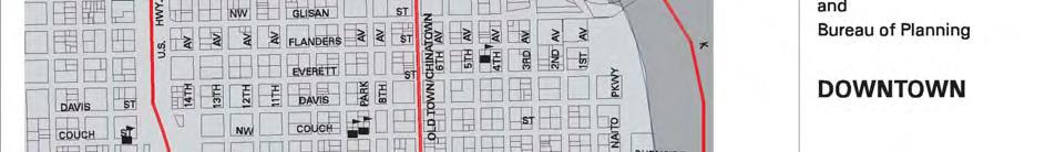
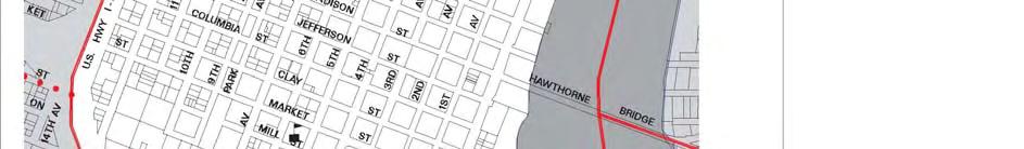
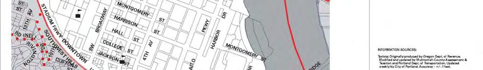
4 BOUNDARIES The Central City Plan boundary contains 9 sub-districts, one of which is the Downtown District. Four major boundaries distinguish the Downtown District. The Willamette River forms the eastern boundary, while Interstate 405 forms both the western and southern boundary until it merges with Interstate 5 to the south. The northern boundary for the district is West Burnside Street until it reaches 3 rd Street, at which point the boundary travels southeast in a stair step fashion until it reaches the Willamette River (Figure 2). For the purposes of this report, the Downtown District, as defined by the Central City Plan and as adopted by the Portland Business Alliance, will be the focus of this analysis. The reasoning for designating these 2 boundaries is that they are physically distinguishable on the ground and the area conveniently contains 4 census tracts that allow for the easy analysis of employment and demographic information. Also, the area within the boundary is considered by both the City Planning Department and the Portland Business Alliance to be the City s commercial core (Portland Transportation System Plan 10-15). Attributes of the area include seven residential sub-districts, O Bryant Square, Park Blocks, University District, South Auditorium, Riverplace, City Center, and Skidmore/ Yamhill (Portland Transportation System Plan 10-22). The total land area of the downtown is approximately 630 acres. Tim Drumm and Michael Haak 4


5 Figure 2. Office of Neighborhood Involvement Tim Drumm and Michael Haak 5
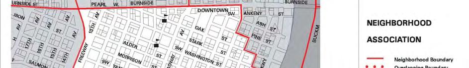
6 CHARACTERISTICS Three Special Areas, or sub-areas, as defined by the Central City Design Guidelines and the 2002 amendment to the Central City Plan, are located within the boundaries of the downtown area. The sub-areas are: (1) Park Blocks, (2) Broadway Unique Sign District, and (3) the West End (Central City Fundamental Design Guidelines 141, Downtown s West End: Amendments to the Central City Plan, Zoning Code, and Zoning Map 2). In addition to the sub-areas, the downtown area also contains the campus of Portland State University, the Portland Art Museum, the Center for the Performing Arts, Pioneer Square, the Brewery Blocks and the Government Center (Figure 3). Park Blocks is a major north south connector for urban activity within the downtown. It is characterized by unique streetscapes, open spaces, historically significant buildings and civic uses. The blocks are also intersected by the Light Rail at Yamhill and Morrison St., which provides east west connectivity within the downtown (Midtown Blocks Planning Study 10). Park Blocks can be divided into three distinct sections: South Park Blocks, Midtown Park Blocks, and North Park Blocks. South Park Blocks is characterized as culturally diverse and is located near Portland State University, the Portland Center for the Performing Arts, and the Government Center. South Park Blocks also has a number of commercial and residential developments adjacent to it (Central City Fundamental Design Guidelines 142). Midtown Park Blocks is commercially developed and is currently within the retail core of the downtown area (Midtown Blocks Planning Study 2). The commercial activity is predominantly in the form of local specialty shops with interspersed entertainment opportunities (Midtown Blocks Planning Study 1). The Midtown Park Blocks represent more of an urban setting when compared to South Park Blocks, but there is interspersed open space within the Midtown Blocks that create a unique atmosphere that is not apparent within the South Park Blocks (Central City Fundamental Design Guidelines 142, Midtown Blocks Planning Study 10). The area has also been identified as a potential location for mid- to high-end housing to help support the downtown retail core in the future (Midtown Blocks Planning Study 7). Tim Drumm and Michael Haak 6
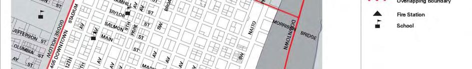
7 North Park Blocks is located outside of the downtown area boundary that is being used for this analysis. The overall goals for this sub-area are concerned with maintaining the diverse culture that presently exists and enhancing the connective elements between the three distinct sections (Central City Fundamental Design Guidelines 144). There is also an emphasis on reusing existing historical structures within Park Blocks and enhancing park amenities (Central City Fundamental Design Guidelines 145). The Broadway Unique Sign District is the entertainment district for the downtown. The area is dominated by theaters, nightclubs, restaurants, and hotels. The sub-area is managed to emphasize the large historically significant signs that run the length of both Broadway and Burnside Streets (Central City Fundamental Design Guidelines 150). Although it may be counter to existing zoning regulations concerning signage in the downtown area, new signage must reflect the historical character within this special sub-area (Central City Fundamental Design Guidelines 150). Specifically, signage is required to be vertically oriented when it is mounted close to the façade of the building it is highlighting. It is also suggested that neon lighting be used to convey a sense of energy and excitement within the area (Central City Fundamental Design Guidelines 152). The West End is approximately 50 acres in size and it is dominated by a mix of residential and commercial uses. Although commercial and retail activities do exist, the area is considered under-built with low Floor Area Ratios (Downtown s West End: Amendments to the Central City Plan, Zoning Code, and Zoning Map 10). The unique characteristic of this particular sub-area is that approximately 20% of the area is surface parking lots and that its western boundary is Interstate 405 (Downtown s West End: Amendments to the Central City Plan, Zoning Code, and Zoning Map 10). The area also has a large amount of low to mid-income housing and contains approximately 9% of the employment for the downtown (Downtown s West End: Amendments to the Central City Plan, Zoning Code, and Zoning Map 10). The existing conditions within this particular sub-area have been the recent focus of planning within the City of Portland. The existing surface parking is being analyzed to determine how to condense it into parking structures, and the resulting properties are being considered for both retail and residential development (Downtown s West End: Amendments to the Central City Plan, Zoning Code, and Zoning Map 17). Also, due to its proximity to Midtown Blocks and the under-built nature of the Tim Drumm and Michael Haak 7
8 area, traditional downtown retailers are showing interest in establishing a regional retail center within the sub-area (Midtown Blocks Planning Study 1). The Midtown Blocks Planning Study actually identifies the West End as potentially being a high density community retail center that should help solidify the retail within the downtown. It also acknowledges that the sub-area s proximity to Midtown Blocks and the availability of transit within the sub-area creates a unique opportunity to connect multiple amenities within the entire downtown area (Midtown Blocks Planning Study 1, 2, 4). The 2002 Amendment to the Central City Plan also identifies improvements to the streetscape to improve connectivity to the other sub-areas and maintaining the stock of affordable housing within the area (Downtown s West End: Amendments to the Central City Plan, Zoning Code, and Zoning Map 18). To encourage developers to maintain affordable housing, the city is offering bonuses for increased floor area in exchange for contributions into an affordable housing fund (Downtown s West End: Amendments to the Central City Plan, Zoning Code, and Zoning Map 18). Overall, the West End has the greatest potential for increasing residential density and maintaining the retail core of the downtown area (Midtown Blocks Planning Study 6). The sub-areas that are identified above face varying challenges, but the interstate that surrounds the downtown area presents the biggest challenge to development within the downtown area. Although the interstate is not a sub-area within the downtown, it has a direct affect on the economic and social stability within the downtown as well as the overall built environment within each of the sub-areas. Interstate 405 was designed and built with a smaller city in mind and is now constraining development within the downtown area (Freeway Loop Study 1). A recent study by the Portland Bureau of Planning and the Oregon Department of Transportation found that although the loop needs to be retained, it hinders quality urban development, and existing congestion is likely to get worse without significant investment to expand the existing loop (Freeway Loop Study 2). The study also identifies the possibility of missed economic, cultural, and civic opportunities because the loop is a barrier to connectivity and a constraint to commercial, residential and recreational development within the downtown area (Freeway Loop Study 6). To address the challenges posed by the loop, the City and the Oregon Department of Transportation initiated a Master Planning Process for the loop to analyze potential options for improving the existing conditions. Three options will be considered during the planning process: (1) modest improvements to the existing loop, such as Tim Drumm and Michael Haak 8
9 braiding on and off ramps, (2) creating a one-way loop, which would allow for the removal of some of the existing infrastructure that is presently constraining development, and (3) building a tunnel, which would allow for the removal of the southern portion of the interstate. The process is expected to be completed in 2009 (Freeway Loop Study 13). Tim Drumm and Michael Haak 9

10 Figure 3. Central City Assessment Base Map Tim Drumm and Michael Haak 10
11 ZONING The City of Portland has had three different zoning codes. The original zoning code was adopted in 1924 followed by a 1959 zoning code with the most recent code being adopted by Ordinance # in January, 1991 (Portland Zoning Code, 1991). The most recent code is the product of the diligent effort of multiple city and county agencies, business groups, as well as a myriad of other individuals and organizations. There are four major zone districts, four overlay zone districts, and two special zone districts within the defined downtown area. The districts and overlay zones depicted by Figure 4 are described in the following text. Open Space Zone (OS) The Open Space Zone is intended to preserve and enhance public and private open, natural, and improved park and recreational areas identified in the Comprehensive Plan. These areas serve many functions including: Providing opportunities for outdoor recreation; Providing contrasts to the built environment; Preserving scenic qualities; Protecting sensitive or fragile environmental areas; Preserving the capacity and water quality of the stormwater drainage system; and Providing pedestrian and bicycle transportation connections (Portland Zoning Code, 1991). Central Residential Zone (RX) The RX zone is a high density multi-dwelling zone which allows the highest density of dwelling units of the residential zones. Density is not regulated by a maximum number of units per acre. Rather, the maximum size of buildings and intensity of use are regulated by floor area ratio (FAR) limits and other site development standards. Generally the density will be 100 or more units per acre. Allowed housing developments are characterized by a very high percentage of building coverage. The major types of new housing development will be medium and high rise apartments and condominiums, often with allowed retail, institutional, or other service oriented Tim Drumm and Michael Haak 11
12 uses. Generally, RX zones will be located near the center of the city where transit is readily available and where commercial and employment opportunities are nearby. RX zones will usually be applied in combination with the Central City plan district (Portland Zoning Code, 1991). Central Employment Zone (EX) This zone implements the Central Employment map designation of the Comprehensive Plan. The zone allows mixed-uses and is intended for areas in the center of the City that have predominantly industrial type development. The intent of the zone is to allow industrial, business, and service uses which need a central location. Residential uses are allowed, but are not intended to predominate or set development standards for other uses in the area. The development standards are intended to allow new development which is similar in character to existing development (Portland Zoning Code, 1991). Central Commercial Zone (CX) The Central Commercial (CX) zone is intended to provide for commercial development within Portland s most urban and intense areas. A broad range of uses is allowed to reflect Portland s role as a commercial, cultural and governmental center. Development is intended to be very intense with high building coverage, large buildings, and buildings placed close together. Development is intended to be pedestrian-oriented with a strong emphasis on a safe and attractive streetscape (Portland Zoning Code, 1991). Design Overlay Zone (d) The Design Overlay Zone promotes the conservation, enhancement, and continued vitality of areas of the City with special scenic, architectural, or cultural value. This is achieved through the creation of design districts and applying the Design Overlay Zone as part of community planning projects, development of design guidelines for each district, and by requiring design review or compliance with the Community Design Standards. In addition, design review or compliance Tim Drumm and Michael Haak 12
13 with the Community Design Standards ensures that certain types of infill development will be compatible with the neighborhood and enhance the area (Portland Zoning Code, 1991). Greenway Overlay Zones (g) The Greenway regulations are intended to: Protect, conserve, enhance, and maintain the natural, scenic, historical, economic, and recreational qualities of lands along Portland s rivers; Establish criteria, standards, and procedures for the development of land, change of uses, and the intensification of uses within the greenway; Increase public access to and along the Willamette River for the purpose of increasing recreational opportunities, providing emergency vehicle access, assisting in flood protection and control, providing connections to other transportation systems, and helping to create a pleasant, aesthetically pleasing urban environment; and Implement the City s Willamette Greenway responsibilities as required by ORS to ; and Implement the water quality performance standards of Metro s Title 3, which are intended to protect and improve water quality to support designated beneficial water uses, and to protect the functional values of the water quality resource area which include: providing a vegetated corridor to separate protected water features from development; maintaining or reducing stream temperatures; maintaining natural stream corridors; minimizing erosion, nutrient and pollutant loading into water; filtering, infiltration and natural water purification; and stabilizing slopes to prevent landslides contributing to sedimentation of water features (Portland Zoning Code, 1991). River Recreational Zone (r) The River Recreational zone encourages river-dependent and river-related recreational uses which provide a variety of types of public access to and along the river, and which enhance the river s natural and scenic qualities (Portland Zoning Code, 1991). Tim Drumm and Michael Haak 13
14 River General Zone (g) The River General zone allows for uses and development which are consistent with the base zoning, which allows for public use and enjoyment of the waterfront, and which enhance the river s natural and scenic qualities (Portland Zoning Code, 1991). Central City Plan District The Central City plan district implements the Central City Plan and other plans applicable to the Central City area. These other plans include the Downtown Plan, the River District Plan, the University District Plan, and the Central City Transportation Management Plan. The Central City plan district implements portions of these plans by adding code provisions which address special circumstances existing in the Central City area (Portland Zoning Code, 1991). South Auditorium District The South Auditorium plan district protects the unique character of the former South Auditorium urban renewal district. The District is an award-winning development, with its high-rise buildings, generous setbacks and landscaping, numerous plazas and fountains, and an elaborate pedestrian walkway system. Maintenance of this character is achieved by requiring additional landscaping requirements, the preservation of existing trees, screening of roof-top equipment, and additional sign regulations which limit the type, number, and size of signs (Portland Zoning Code, 1991). Tim Drumm and Michael Haak 14

15 Figure 4. Portland Zoning Map Tim Drumm and Michael Haak 15
16 POPULATION The downtown area includes census tracts 53, 54, 56, and 57. The total population within the downtown area for the year 2000 was 9,290 people. Census tract 56, which includes the southwest corner of the downtown area, contains the greatest number of people within the downtown at 3,753 (American FactFinder). In 2005, the population within the downtown was approximately 13,400, up approximately 44% from year 2000, and is expected to rise nearly 20% more to 16,100 by 2010 (Downtown Portland Retail Strategy 69). The residential population within the Downtown sub-area has grown substantially within the last decade. The City of Portland Bureau of Planning cites the city s commitment to increasing residential development within the downtown area during the 1980s as the reason for this growth. In fact, within the last decade an average of 1000 residential units per year has been constructed within the downtown area. In 2006, 3,200 residential units are currently under construction, with another 4,700 going through the planning and permitting process (Karl Lisle, City of Portland Planning Bureau). The focus on residential development within Portland s downtown is directly related to the housing policy of the Central City Plan. It is also attributed to the rise in employment within Multnomah County from 335,000 jobs in 1980 to 428,000 jobs in 2005 (A Few Facts about Portland s Economy Since 1980). The Central City Plan, which was amended in 1995 to address the increasing population within the Central City, calls for highdensity housing that reflects the creation of new jobs within Central City. The Plan establishes a goal of creating an additional 75,000 jobs and increasing housing units by 15,000 by the year 2010 (Central Portland Plan: Assessment Precedent Case Studies4). It also recommends offering housing incentives to attract infill development and to help maintain Portland s urban growth boundary (Central City Plan 72). Unfortunately, the focus on residential development has slowed the market for commercial and office properties and incentives are being considered to increase the commercial development within the downtown (Karl Lisle, City of Portland Planning Bureau). In 2000, almost one-half of Oregon s population lived within the Portland Metropolitan Area (Oregon Outlook 1). The large population concentration can be attributed to a number of factors, but the largest factor may be net in-migration due to strong economic conditions and Tim Drumm and Michael Haak 16
17 employment opportunities of the late 1980s to the late 1990s. In fact, strong economic conditions and job opportunities within the Portland Metropolitan Area attracted large numbers of California residents looking for better economic conditions during that period of time (Oregon Outlook 2). In addition, during that period, growth occurred more rapidly in outlying areas than within the downtown area mainly due to the establishment of jobs within those areas (Oregon Outlook 5). However, recognizing the need for housing and commercial development within the downtown area, infill development was encouraged in the mid to late 1990s and is still encouraged today (Karl Lisle, City of Portland Planning Bureau). Initially, residential development was the focus of the new development to house the influx of residents to the Central City, but now incentives are being considered to encourage an increase in commercial development to further density goals within the downtown (Karl Lisle, City of Portland Planning Bureau). Due to Portland s economic health, and the city s policies concerning housing incentives and economic growth, Portland State University s Population Research Center believes that Portland s population will grow substantially within the next decade. The Population Research Center is expecting the annual population growth between 2000 and 2010 to be 1.8% (Oregon Outlook 8). DEVELOPMENT Development in Downtown Portland is a prime example of effective public-private partnerships that result in vibrant city centers. As the area continues to develop into a thriving self sufficient community, certain data related to the area is valuable in producing trends that may prove to be beneficial to Downtown Denver. The charts provided should provide a picture of the trends seen in the Downtown Portland Retail, Office, and residential markets. VACANCY RATES Retail Downtown Portland Retail Vacancy Rates over the last 10 years has slightly fluctuated from 3.93% in 1996 to 5.20% in 2 nd Quarter The 10 year high occurred in 2003 at 5.8% and the 10 year low of 3.54% occurred in 1998 as seen in Figure 5. This relatively steady trend line for retail vacancy rates in the downtown area shows that Portland retail is a strong economic Tim Drumm and Michael Haak 17
18 engine and plays an important role in the downtown economy. The slight rise and decline in vacancy rates could be contributed to renovated and constructed buildings that have yet to be absorbed when vacancy rate information is available. Limited land for future development in the downtown area will help new shopping centers obtain maximum tenant occupancy for the near future. This will help vacancy rates to maintain current levels with slight decreases as we progress through 2006 (CB Richard Ellis, 2006). Portland CBD Vacancy Rates 12.00% 10.00% 10.82% 10.50% 9.65% 9.82% 9.11% 8.00% 8.04% Percent Vacant 6.00% 4.00% 5.62% 3.93% 5.20% 4.04% 4.66% 3.54% 6.44% 4.04% 4.89% 4.97% 4.48% 4.95% 5.80% 4.40% 5.12% 5.20% Portland CBD Office Vacancy Rates Portland CBD Retail Vacancy Rates 2.00% 0.00% Year Figure 5. (Source: CB Richard Ellis) Office Downtown Portland Office Vacancy Rates have not seen a steady trend over the last 10 years much like retail vacancy numbers. Over 36% percent of the office space in Portland, Oregon is located in the Central Business District (CBD) with almost one half of the total office space located in the Downtown area. Data for the Portland CBD indicates the spike in office vacancy rates seen in the 2001 time frame could be contributed to September 11, 2001 and the public s fear of similar attacks on downtown office buildings. However, there may be many other economic indicators that could be contributing factors to the increase in vacancy rates over that time period. As the chart above depicts, office vacancy rates are slowly declining. Portland Office MarketView Studies completed by CB Richard Ellis estimate that the office market will Tim Drumm and Michael Haak 18
19 continue to improve slowly as available space and subleased space is leased up (CB Richard Ellis, 2006). Residential Inconsistent residential data for the downtown area was difficult to analyze and interpret. However, Table 1 displays residential vacancy information that was made available by Norris, Beggs & Simpson. Residential Data provided by Norris, Beggs & Simpson is limited to multifamily units. No data on single-family residential was accessible. Data includes information on studios, 1BR/1BA, 2BR/1BA, 2BR/2BA, 3BR/1BA, and 3BR/2BA units. In the Portland area the Downtown market leads the multi-family market with vacancy rates for new units at 0.76% and seasoned units at 1.8% (NAI, Multifamily Market Report, 2Q 2006). Denver Table 1 Vacancy Rates Portland Office Retail Residential Office Retail Residential % 14.51% 5.10% 5.62% 3.93% 8.50% % 4.95% 4.00% 5.20% 4.04% % 10.71% 1.70% 4.66% 3.54% 1.20% % 7.85% 4.40% 6.44% 4.04% 5.13% % 9.62% 2.60% 4.89% 4.97% % 9.04% 6.60% 8.04% 4.48% % 5.45% 7.70% 9.65% 4.95% 2.95% % 5.88% 23.40% 9.82% 5.80% 6.74% % 4.69% 9.20% 10.82% 4.40% 5.63% % 2.36% 7.30% 10.50% 5.12% 5.72% % 2.23% 6.00% 9.11% 5.20% 1.40% Source: CB Richard Ellis, Downtown Denver Partnership, and Norris Beggs & Simpson RENTAL RATES Retail Asking retail lease rates vary widely in the Portland Central City depending on location. The low end of the market is $12.00 per square foot per year for ground floor retail space outside the Tim Drumm and Michael Haak 19
20 retail core in downtown. $35.00 is the high end of the market. (E. D. Hovee & Company, 2005). The retail vacancy rates in downtown Portland have remained fairly steady over the last 10 years, there is a visible increase in retail rental rate trends. Rental rates have increased by nearly $2.00 or roughly 10% per SF from 2005 to Since 1996 retail rental rates have increased at an annual rate of 4.07% as seen in Figure 6. This increase is likely due to some opportunities and strengths identified by Leland Consulting Group in their Downtown Retail Study. Several of these opportunities include the completion of opening of Pioneer Place in early 1990 and the expansion in 2000 which is a downtown Mixed-Use Project consisting of 3.5 city blocks, 100 retail stores, 180 parking spaces, and a 60,000 SF Saks Fifth Ave department store. The study also identifies many leading fashion vendors located in the downtown area, downtown hotels attracting strong visitor market, nightlife entertainment districts, and new housing. Retail in Downtown Portland is strong. A downtown office worker supports 7.8 SF of retail while a downtown household supports up to 18 SF of retail (Leland Consulting Group, November 1, 2006). Portland s high downtown residential density supports the area retail stores. Portland CBD Rental Rates $22.50 $20.64 Rental Rate (Per Sq. Foot) $20.00 $17.50 $15.00 $19.46 $18.95 $19.00 $18.63 $17.40 $16.79 $17.37 $15.66 $15.63 $16.79 $16.15 $14.42 $15.92 $15.76 $15.13 $15.48 $14.67 $19.23 $19.54 Portland CBD Office Rental Rates Portland CBD Retail Rental Rates $13.67 $13.64 $12.50 $ Year Figure 6. (Source: CB Richard Ellis) Tim Drumm and Michael Haak 20
21 Office Downtown Portland Office Rental Rates (Figure 6) were at a 10 year high in 2001 at an average rate of $20.64 per SF. Office rental rates increased at an average annual rate of 8.6% from 1996 to Since the uncharacteristically high office rental rates in 2001, rates have decreased and maintained a steady constant of roughly $19.00 per SF according to most recent data available from CB Richard Ellis. With lease rates slowly increasing and tenant improvement decreasing, tenants will have to find additional ways to finance improvements for existing or new space. The most recent increase in rental rates is partly due to a major conversion of over 42,000 SF from single to multi-tenant occupancy (CB Richard Ellis, 2006). Residential According to Norris, Beggs & Simpson Quarterly Multi-Family Market Report, the multi-family market is looking up for A dramatic increase of effective rents is occurring due to lower vacancy and reduced concessions. According to the data that was made available from NAI, previous residential average rental price per SF has remained fairly constant over the past 5 years at an average rate of $1.28 per SF (Table 2). The Metro Multifamily Housing Association Fall 2004 Apartment Report states: House prices with no down, little or no closing costs, and very low interest rates continue to attract apartment residents. Almost everyone can qualify for home loans these days through government programs and local housing agencies. (E. D. Hovee & Company, 2005). This may indicate a continued increase in the number of rental properties available for the downtown area. Tim Drumm and Michael Haak 21
22 Denver Table 2 Rental Rates Portland Office Retail Residential Office Retail Residential 1996 $15.63 $ $14.42 $ $15.33 $ $15.66 $ $16.67 $ $15.63 $ $19.25 $ $16.79 $ $20.75 $25.50 $0.90 $17.40 $ $20.00 $19.50 $0.96 $20.64 $ $19.00 $19.50 $0.98 $19.46 $15.48 $ $15.00 $19.50 $0.92 $18.95 $16.15 $ $17.00 $18.50 $0.96 $19.00 $16.79 $ $18.00 $20.25 $1.00 $18.63 $17.37 $ $18.00 $20.00 $1.03 $19.23 $19.54 $1.28 Source: CB Richard Ellis, Downtown Denver Partnership, and Norris Beggs & Simpson Change in the Type of Development In the 1980s there was a major push to encourage residential development in the downtown area. However, the bulk of new construction in the 1980s was office/commercial. The current market is the exact opposite with the majority of new construction being residential in nature (Karl Lisle, City of Portland Planning Bureau). However, from various sources and data gathered over the course of this study, trends indicated that mixed use developments are on the rise in the downtown Portland area. Developments similar to the recently completed three-block catalyst mixed-use project Museum Place development, which is located in the West End, includes apartments, a new Safeway, condominiums, affordable housing, and a renovated downtown YWCA continue to pop up around Downtown Portland. Encouraging Redevelopment Urban renewal areas and the promotion of public/private partnerships have the greatest impact on promoting quality redevelopment in Downtown Portland. The Portland Development Commission and the City of Portland s commitment to downtown revitalization and development is an outstanding representation of what cities should seek to accomplish. Urban renewal funds in Portland are used for a variety of investments, such as redevelopment projects, including Tim Drumm and Michael Haak 22
23 mixed-use projects; economic development strategies, such as small business improvement loans and loan programs tied to family-wage jobs; housing loans and other financial tools, for new and rehabilitated housing, streetscape improvements including new lighting, trees, and pedestrian facilities as well as parks and open spaces (Annual Urban Renewal Report, 2006). RETAIL The retail core in the downtown area is a 17 square block area around Pioneer Courthouse Square. This area, which is considered to be the heart of Portland, is bounded by Alder Street, SW 9 th Avenue and Park Blocks Taylor Street and SW 3 rd Avenue. The core is primarily comprised of 3 major department stores Nordstrom, Macy s, and Saks Fifth Avenue which account for nearly 464,000 SF of the roughly 1.2 Million SF of retail space located within the downtown boundary. There are several trends that can be seen in downtown retail according to Leland Consulting Group s November 1, 2006 Study: Downtown Retail Opportunities, Constraints & Strategies. The retail trends identified in the downtown area include the arrival of Big Boxes in downtowns, two-story formats for stores such as Target, Whole Foods & other discounters, as well as smaller formats for department stores such as JC Penney s and Macy s. Quantitative trends identified in the study note that 60-65% of sales are at discount prices, 35% or more of sales are in discount department stores, and this number is continually rising. Lastly, 70% of sales occur after 5:30 PM and on Sundays. As the population steadily moves back in to urban neighborhoods, urban places have a positive outlook. Outdoors lifestyle centers such as the Denver Pavilions and 24-Hour retailers are on the rise and considered to be a strong trait for downtown areas while the enclosed mall and outlet centers are on the decline. Due to Portland s economic recovery and population growth, retail sales are projected to increase 2.5% in 2006 (CBRE, Retail MarketView, 4Q 2005). Portland Downtown Services, Inc. (PDSI) is a private, nonprofit organization that contracts with the Portland Business Alliance to provide marketing and economic development programs to downtown property owners. This organization was created with the formation of the Business Tim Drumm and Michael Haak 23
24 Improvement District. Downtown Portland's Business Improvement District (BID) encompasses a 213-block area of downtown Portland. Businesses within this district tax themselves to raise money that supplements publicly-financed services for neighborhood improvement. Portland's BID funds the Downtown Clean & Safe Program, which provides cleaning, security and community justice services downtown; the Downtown Retail and Marketing Program, which focuses on market research, retail advocacy, marketing and communication; and the Sidewalk Ambassador Program, which offers information and assistance to downtown visitors (Portland Business Alliance, 2006). PARKING Parking Management The City of Portland Office of Transportation manages parking operations as well as parking enforcement within the downtown area. In addition to the Office of Transportation, Tri-met, which is a municipal corporation of the State of Oregon and has a primary function of public transit management, assists the city by managing commuter lots at transit centers and administers revenue to Transportation Management Associations and select programs that promote carpooling (Fiscal Year Adopted Budget 452, Portland Transportation System Plan 5-149, 5-157). Parking operations by the Office of Transportation include the management of 7 Smart Park garages and the administration of two parking meter districts, one of which is located in the downtown area. The Office of Transportation is also responsible for the administration of the Area Parking Permit Program, which is meant to control on-street commuter parking in residential areas that are adjacent to transit centers and commercial districts (Portland Transportation System Plan 5-156). Tri-met manages the carpooling programs within the Central City, which includes 1,284 spaces that are provided by the City of Portland. The programs primarily offer parking at reduced rates for carpools (Portland Transportation System Plan 5-147). The carpooling programs administered by Tri-met also include assisting with the funding for the Transit Management Alliance, which involves the promoting of carpooling, and the partial funding of Transportation Tim Drumm and Michael Haak 24
25 Management Associations within the Central City. The function of the Transportation Management Associations is to address local transportation problems within particular districts. Tri-met also provides technical assistance to the Associations (Portland Transportation System Plan 5-148). Unfortunately, there is presently no Transportation Management Association within the downtown area, but it has been identified as a deficiency within the Central City Transportation Management Plan (Central City Transportation Management Plan 9). The revenue generated by the parking meters, the city owned garages, the Area Parking Permit Program, as well as a percentage of parking citations, is reinvested into the parking management and maintenance of the existing facilities (Revenue Sources 1). When there is excess revenue available, the funds are diverted into the General Fund. The General Transportation Revenues (General Fund) are then dispersed to a number of programs throughout the Central City. For instance, revenues are often utilized to make payments to the downtown streetcar debt or used to provide matching funds for federal or State grants. Another beneficial program that the General Transportation Revenues support is the establishment and perpetuation of Transportation Management Association (Portland Transportation System Plan 14-7). To increase revenue to help pay for parking management, maintenance, and the perpetuation of the Department s initiatives, the Portland Department of Transportation identified four revenue initiatives in the Fiscal Budget. The four initiatives are: (1) to increase cost recovery for their Area Parking Permit Program, (2) to increase the citation bail amount for parking citations, (3) to reduce the percentage of the share the District Court receives for parking citations, and (4) to create a Banner Sponsorship Program where businesses may advertise to the public (Fiscal Year Adopted Budget 455). Parking Policies The State of Oregon s Transportation Planning Rule requires actions which are designed to change travel behavior in order to improve performance of transportation facilities and reduce the need for additional road capacity. To achieve that goal, it requires reducing parking spaces by 10% per capita over a 20 year period and creating minimum and maximum parking regulations (Portland Transportation System Plan 5-138). To meet the requirements of the Transportation Planning Rule, the transportation Demand Management and Parking Plan adopted several policies and objectives within the City of Portland s Comprehensive Plan. For Tim Drumm and Michael Haak 25
26 instance, parking management and parking supply is to be managed to achieve transportation policy objectives for neighborhood and business district vitality, auto trip reduction, and improved air quality (Portland Transportation System Plan 5-143: Policy 6.26). In addition, the supply of on-street parking is managed to encourage economic vitality, safety for all modes, and livability of residential neighborhoods (Portland Transportation System Plan 5-143: Policy 6.27). Finally, the bulk of Off-street parking is influenced more by zoning regulations and minimum and maximum ratios than on-street parking. Off-street parking needs are based more on availability of transit, and how limitations on new parking can help achieve land use, transportation, and the environmental goals (Portland Transportation System Plan 5-144: Policy 6.28). The Comprehensive Plan identifies the overall goal of regulating off-street parking to maintain good urban form and the economic vitality of business districts. To implement some of the policies, Portland has created parking meter districts to encourage the use of alternative modes of transportation, developed a Smart Park garage system to provide parking for downtown shoppers, and established carpooling programs, such as employer-paid subsidies and discounted parking, to reduce the number of commuting vehicles at downtown parking areas (Portland Transportation System Plan 5-154, 155). Regulations Parking regulations for commercial lots within the Central City are dictated by the Central City Transportation Management Plan and are subject to the Central City Parking Review. The Central City Parking Review was created to regulate commercial parking structures within the core area of the downtown. Commercial lots must undergo a certification process to ensure that they are not a detriment to the overall atmosphere of the downtown area (Central City Parking Review 808-1). Criteria for certification include issues such as transportation capacity, whether it conforms to existing zoning, and overall public health and safety (Central City Parking Review 808-2). If commercial lots fail to meet the criteria identified within both the Central City Transportation Management Plan and the Central City Parking Review, their certification can be withheld or revoked, and the parking area will be required to reapply for a use certification or they will be construed as a nonconforming use (Central City Parking Review 808-2). When a commercial lot is certified, it is subject to the zoning regulations that are dictated by the Central City Transportation Management Plan. The zoning regulations identify 6 types of Tim Drumm and Michael Haak 26
27 parking lots that are subject to Central City Parking Review: (1) Growth Parking, which involves the expansion of existing parking when the facilities it is serving expand, (2) Preservation Parking, which serves existing older buildings, (3) Visitor Parking, (4) Undedicated General Parking, which is everything that is not visitor parking, (5) Residential/ Hotel Parking, and (6) RX Zone Parking (Central City Plan District ). Within the downtown, Growth, Visitor, and Residential/ Hotel Parking are primarily managed as short-term parking because of an emphasis within the Central City Transportation Management Plan for alternatives to single occupancy vehicle (Central City Parking Review 808-3). For instance, five spaces of Growth Parking must be reserved for carpooling vehicles to encourage alternative modes of transportation (Central City Plan District ). In addition, the Central City District Plan requires commercial operators of Growth, Visitor, and Residential/ Hotel Parking to supply the City Parking Manager with yearly operating reports. The reports include the number of spaces within the lot, whether the lots are short or long-term parking spaces, and whether carpooling spaces are being utilized. Failure to follow through with the reports can result in revoking the Central City Parking Review certification (Central City Plan District , 65). Preservation Parking is predetermined by the City Parking Manager and is limited to offices, retail services, medical centers, universities, and industrial services (Central City Plan District ). The buildings that the Preservation Parking is servicing need to be identified, and the owner of the parking lot needs to sign an agreement that the parking will be made available for a period of 10 years. In addition, operating reports need to be supplied to the City Parking Manager every 6 months (Central City Plan District , 70). Parking areas that are associated with the RX Zone Parking may only be accessory and cannot be used as a commercial lot (Central City Plan District ). Undedicated general parking is prohibited in the downtown area (Central City Plan District ). In addition, hours of operation for each parking type are dictated within the Central City Plan District document as well as landscaping standards (Central City Plan District ). For instance, any parking lot that is over 3 acres is required to landscape with street-like features, such as wheel stops, curbing sidewalks, and trees for screening (Portland Transportation System Plan 5-139). Tim Drumm and Michael Haak 27
28 Overall, the Office of Transportation Management manages 46,466 spaces: 35,645 off-street, 3451 residential/ hotel, 6,215 metered, 886 loading zone, 148 administrative, and 121 timed zones. In addition, the Smart Park garages add an additional 3,500 spaces for downtown shoppers looking for short term parking (Facts about Portland 4). POLICIES AND POLITICS In 2000, increased interest in preserving the riverfront along the Willamette River spurred the City into creating the River Renaissance Vision. The vision has five general themes: (1) to ensure a clean and healthy river system; (2) maintain and enhance the city s prosperous harbor; (3) embrace the river and its banks as Portland s front yard; (4) create vibrant waterfront districts and neighborhoods; and (5) promote partnerships, leadership, and education (River Renaissance Strategy 1-2). The five general themes relate to existing policies within the Central City, such as greenway establishment for pedestrian and bicycle thoroughfares, but the focus of the existing policies onto the riverfront create a new district that is dependent on the health of a unique natural resource that will eventually serve as the centerpiece of the City. The idea of the vision was to change the perception of the river from an obstacle to development and transportation to an opportunity for creating a unique urban environment that would attract economic interests into the Central City (River Renaissance Strategy 6-5). Since the creation of the River Renaissance Strategy in 2004, a number of individual plans have been created that reflect the overall themes of the River Renaissance Strategy. For instance, The River Plan: the River Concept was adopted in 2005 to direct development within specific riverfront districts and outlines specific policies within each new district ( State of the River Report 7). The plan divides the Willamette into three distinct districts; (1) the North Reach, which is heavily industrial; (2) the Central Reach, which includes most of the Central City and will emphasize civic space; and (3) the South Reach, which is primarily nature areas and neighborhoods ( State of the River Report 7). Since 2004, the North Reach has seen an increase in harbor activity and jobs related to cargo handling; the Central Reach has increased pedestrian thoroughfares along the corridor and has increased public and private development; and the South Reach has increased housing Tim Drumm and Michael Haak 28
29 development and has enhanced natural areas through civic involvement ( State of the River Report 15, 16, 18, 20). Plans, such as the River Renaissance Strategy, are directing development along the river and providing the City with additional opportunities for economic development as well as maintaining an overall interest in downtown Portland. Utilizing the river as a unique natural resource has allowed Portland to reinvigorate itself and recreate interest in its extensive natural areas and parks. COMPARE/CONTRAST TO DOWNTOWN DENVER INTRODUCTION The Cities of Portland, Oregon, and Denver, Colorado, are similar in a number of ways, but their differences create unique planning environments in both cities. Portland s unique geographic location creates planning challenges that Denver will never experience, and the large suburban ring that surrounds Denver will always be an economic challenge to the downtown area. However, the downtowns share enough of the same traits that important lessons could be learned from mistakes and successes of both cities. BOUNDARIES The downtown Denver boundary utilized by the Downtown Denver Partnership is considerably larger and includes a larger percentage of residential neighborhoods than Portland s downtown boundary. Denver s downtown boundary, as determined by the Downtown Denver Partnership, has approximately a 1.5 mile radius and is 4,518 acres. The boundary contains 12 neighborhoods and the central business district. The Downtown Denver partnership utilizes housing indicators within their boundary to determine overall population growth within their downtown area (Redefining Housing Boundaries and Population Projections 1, 2). Portland s downtown boundary, which is approximately 630 acres, contains residential as well as commercial developments, but the characteristics of Portland s downtown boundary are attributed to physical barriers and the presence of the downtown commercial district within those physical barriers rather than economic indicators. Utilizing the physical attributes that Tim Drumm and Michael Haak 29
30 encompass the downtown, such as the Willamette River and the Interstate 405 loop, allows for easy analysis of demographic and employment information and provides planners with a simple determination of the health of the core downtown. Denver s boundary, which is more focused on housing, may not necessarily reflect a healthy downtown area because it only considers one factor, where as Portland s boundary allows planners to focus on multiple factors because their boundary is more precise. CHARACTERISTICS Denver s commitment to preserving its unique cultural heritage within the downtown core is comparable to Portland. For instance, Portland identifies the Broadway Unique Sign District as being a special sub-area within its downtown. The sign district is considered culturally and historically significant within the City of Portland and zoning regulations as well as design guidelines are in place to protect the sub-area. In Denver, Lower Downtown has similar significance to Portland s Broadway Unique Sign District. The area is predominantly infill development of structures that are of historical significance, with a large number of those buildings having historical wall signs. Like Portland, Denver zoning regulations and design guidelines currently exist within the Lower Downtown sub-area and are aimed at protecting the area s overall character (LoDo Design Guidelines 13). The commitment by both cities to maintain their cultural and historical heritage, in those areas mentioned above as well as additional areas throughout both cities, allows the cities downtowns to maintain a unique identity that is perceivably attractive to both residents and businesses. Tim Drumm and Michael Haak 30
EXISTING COMPREHENSIVE PLAN
 EXISTING COMPREHENSIVE PLAN Town Center Land Use Element: V. LAND USE POLICIES Town Center Mercer Island's business district vision as described in "Your Mercer Island Citizen-Designed Downtown" was an
Policies and Code Intent Sections Related to Town Center
 Policies and Code Intent Sections Related to Town Center The Town Center Vision is scattered throughout the Comprehensive Plan, development code and the 1994 Town Center Plan. What follows are sections
Ivywild On The Creek PRELIMINARY CREEK DISTRICT MASTER PLAN
 Ivywild On The Creek PRELIMINARY CREEK DISTRICT MASTER PLAN Introduction: Rejuvenating an extraordinary Creekside neighborhood THE CREEKSIDE DISTRICT The Ivywild On The Creek Neighborhood District Master
C. Westerly Creek Village & The Montview Corridor
 C. Westerly Creek Village & The VISION Community Vision When the goals of the city are achieved Westerly Creek Village, a distinctive community defined by Montview Boulevard and Westerly Creek, is a strong
Table of Contents. Elm Avenue Improvement Plan City of Waco, Texas. Introduction 1. Existing Context 1 Figure 1 2.
 Table of Contents Introduction 1 Existing Context 1 Figure 1 2 Plan Guidelines 3 Future Urban Form 4 The West-End 4 Main Street 6 The East-End 7 Figure 2 9 Public Improvement Recommendations 7 General
Planning Districts INTRODUCTION
 INTRODUCTION To facilitate detailed examination of development prospects for all areas of the community, Delano has been divided into 14 planning districts. The location of these planning districts is
SECTION ONE: INTRODUCTION. introduction
 introduction 1 INTRODUCTION Since it was first established in 1843 as a trading post for the Hudson s Bay Company, Victoria has evolved into a Provincial capital city that is recognized across Canada and
MALL REVITALIZATION CASE STUDIES
 MALL REVITALIZATION CASE STUDIES DECEMBER 9, 2012 MALL REVITALIZATION OVERVIEW Introduction Sample Case Studies prepared for Lacey Woodland District Steering Committee as it considers strategies to revitalize
Port Lavaca Future Land Use
 Port Lavaca Future Land Use Introduction The City of Port Lavaca is beginning to see sustained growth, after many years of relative stable population. New single family homes, apartments, and businesses
EXHIBIT A. Tax Increment Reinvestment Zone No. 1 (Town Center) First Amended Project Plan 1
 First Amended Project Plan 1") EXHIBIT A Tax Increment Reinvestment Zone No. 1 (Town Center) First Amended Project Plan 1 1 As amended by Resolution No. 2008-02-001(TR1R) of the Tax Increment Reinvestment Zone No.1, and approved to
EXHIBIT A Tax Increment Reinvestment Zone No. 1 (Town Center) First Amended Project Plan 1 1 As amended by Resolution No. 2008-02-001(TR1R) of the Tax Increment Reinvestment Zone No.1, and approved to
Town Center (part of the Comprehensive Plan)
") Town Center (part of the Comprehensive Plan) Mercer Island Town Center Looking North (2014) In 1994, a year-long process culminated in a set of design guidelines and code requirements for the Town Center
Town Center (part of the Comprehensive Plan) Mercer Island Town Center Looking North (2014) In 1994, a year-long process culminated in a set of design guidelines and code requirements for the Town Center
SECTION UNIFIED DEVELOPMENT ORDINANCE SECTION Part 1 Ordinance. ARTICLE 1 Zoning Districts
 SECTION 1-100 UNIFIED DEVELOPMENT ORDINANCE SECTION 1-300 Part 1 Ordinance SECTION 1-100. Introduction. ARTICLE 1 Zoning Districts Crystal Lake strives to maintain a balance of various land uses for a
Joint Meeting City Council and the Plan Commission. September 1st, 2015
 Joint Meeting City Council and the Plan Commission September 1st, 2015 1 The City Plan Commission shall recommend a City Plan for the physical development of the City Article IX Section 2 of the City of
S A C R A M E N T O C O U N T Y JACKSON HIGHWAY & GRANT LINE EAST VISIONING STUDY
 JACKSON HIGHWAY & GRANT LINE EAST S A C R A M E N T O C O U N T Y P L A N N I N G D E P A R T M E N T SUMMARY AND WORKBOOK November 19, 2008 History of the Visioning Study Sacramento County has two growth
FUTURE LAND USE ELEMENT
 FUTURE LAND USE ELEMENT GOAL I: To create and sustain a great place to live, play, and prosper Objective 1: The City of Ocala shall incorporate the principles and strategies of the Ocala 2035 Vision into
CITY OF COLWICH COMPREHENSIVE PLAN LAND USE LAND USE 1
 LAND USE LAND USE 1 WHAT YOU WILL FIND IN THIS CHAPTER: Discussion of today s conditions and tomorrow s projections Discussion of challenges and opportunities Discussion of the environmental quality goals,
RETAIL MARKET ANALYSIS
 8 RETAIL MARKET ANALYSIS Kyle Smith Portland State University Retail vacancy rates remained unchanged during the second quarter at 8.0 percent, but there was negative absorption of 20,547 square feet according
The transportation system in a community is an
 7 TRANSPORTATION The transportation system in a community is an important factor contributing to the quality of life of the residents. Without a sound transportation system to bring both goods and patrons
CITY OF PUYALLUP. Background. Development Services
 CITY OF PUYALLUP Development Services 333 South Meridian Puyallup WA 98371 To: City Council From: Katie Baker, AICP, Planning Division Re: South Hill Neighborhood Plan Adoption Date: (Meeting date: February
Sheridan Boulevard S TAT I O N A R E A P L A N S H E R I D A N B O U L E VA R D S TAT I O N A R E A P L A N
 Sheridan Boulevard S TAT I O N A R E A P L A N 1 City of Lakewood Adopted November, 2006 S H E R I D A N B O U L E VA R D S TAT I O N A R E A P L A N The Vision The City of Lakewood s overall vision is
REGIONAL ACTIVITY CENTER
 DRAFT REGIONAL ACTIVITY CENTER 70 EAST BENCH MASTER PLAN DRAFT 06 Introduction The East Bench Regional Activity center is comprised of large educational, research, medical, and employment centers. These
DRAFT Land Use Chapter
 Stevens Creek Urban Village DRAFT 1 18 17 Land Use Chapter INTRODUCTION This Land Use Chapter describes how the Stevens Creek Urban Village will accommodate the growth that is planned for it in the Envision
Chapter 1: Introduction
 Chapter 1: Introduction The Penn Avenue Community Works Corridor Vision and Implementation Framework presents an integrated communitybased vision and a coordinated, long-term implementation framework for
Midtown Greenway Land Use and Development Plan Executive Summary
 Midtown Greenway Land Use and Development Plan Executive Summary Introduction The Midtown Greenway Land Use and Development Plan sets policy direction for land use and development in the Midtown Greenway
Metro. Activity Center Design Guidelines. Recommendations For Developing Focused, Mixed-Use Commercial/Residential Centers
 Metro Activity Center Design Guidelines Recommendations For Developing Focused, Mixed-Use Commercial/Residential Centers Metro Activity Centers What is a MAC? Legacy, the adopted guide for the future growth
SOUTH NATOMAS COMMUNITY PLAN
 SOUTH NATOMAS Community Plan Part Three : COMMUNITY PLAN AREAS AND SPECIAL STUDY AREAS SACRAMENTO 2030 GENERAL PLAN Contents Community Location... 3-SN-3 Community Vision... 3-SN-4 Community Profile...
2040 LUP is a part of the Comprehensive Plan and carries the same legal authority. Economic Challenges
 1.1. Guiding Anchorage s Growth Where will new residents settle over the next two decades? Where will people work, shop, and play? Will there be enough room to grow? How will Anchorage look? Will growth
Plano Tomorrow Vision and Policies
 Plano Tomorrow Vision and Policies PLANO TOMORROW PILLARS The Built Environment The Social Environment The Natural Environment The Economic Environment Land Use and Urban Design Transportation Housing
Mark-up of the effect of the proposed Bronte Village Growth Area OPA No.18 on the text of section 24, Bronte Village, of the Livable Oakville Plan
 Mark-up of the effect of the proposed Bronte Village Growth Area OPA No.18 on the text of section 24, Bronte Village, of the Livable Oakville Plan Notes: This document is provided for information purposes
Cumberland Region Tomorrow is a private, non-profit, citizen based regional organization working with Greater Nashville Regional Council
 Cumberland Region Tomorrow is a private, non-profit, citizen based regional organization working with Greater Nashville Regional Council and others in the public and private sectors, dedicated to planning
A P P E N D I X B - O P P O R T U N I T Y S I T E S
 A P P E N D I X B - O P P O R T U N I T Y S I T E S OPPORTUNITY SITES As listed in the Land Use Element, the City has identified 15 Opportunity Sites expected to be the focus of change and revitalization
Transportation. Strategies for Action
 Transportation A major priority for the Overlake Neighborhood is to develop a multimodal transportation system. To achieve this system, a balance has to be found among travel, circulation and access needs;
Robbinsdale LRT Station. CDI Development Guidelines. August Overview
 Robbinsdale LRT Station August 2018 Overview The City of Robbinsdale may have the coolest opportunity site along the 13 mile stretch of the Bottineau LRT corridor / Blue Line extension. Located a block
40 Years of Smart Growth Arlington County s Experience with Transit Oriented Development in the Rosslyn-Ballston Metro Corridor
 40 Years of Smart Growth Arlington County s Experience with Transit Oriented Development in the Rosslyn-Ballston Metro Corridor A presentation by the Arlington County Department of Community Planning,
A. WHAT IS A GENERAL PLAN?
 I. Introduction A. WHAT IS A GENERAL PLAN? A general plan is the planning guideline for the future of a city. It contains goals and policies which regulate urban development, the protection of the natural
Developer s Program. The Station at East 54
 Developer s Program The Station at East 54 Existing Conditions The Station at East 54 is proposed for a 1.12 acre site at the northeast corner of Hamilton Road and Prestwick Road, tucked between the East
WEST OAKLAND SPECIFIC PLAN Final Plan. 2. Vision & Goals. 2.1 Community-Based Goals and Objectives
 WEST OAKLAND SPECIFIC PLAN Final Plan 2. Vision & Goals 2.1 Community-Based Goals and Objectives June 2014 2: Vision & Goals The vision of the West Oakland Specific Plan is to see this remarkable community
QUEEN-RIVER SECONDARY PLAN
 34 QUEEN-RIVER SECONDARY PLAN 34. QUEEN RIVER SECONDARY PLAN 1. INTRODUCTION The Queen-River area is approximately 6.4 hectares and is located at the eastern edge of the Downtown as shown on Map 34-1.
A BLUEPRINT FOR BROCKTON A CITY-WIDE COMPREHENSIVE PLAN
 A BLUEPRINT FOR BROCKTON A CITY-WIDE COMPREHENSIVE PLAN Public Meeting October 2016 1 Plan Summary and Discussion Public Meeting May 4 2017 City of Brockton Bill Carpenter, Mayor Department of Planning
Silverdale Regional Center
 Silverdale Regional Center Vision for Silverdale Regional Center The Silverdale Regional Center Plan (Plan) will guide the evolution of the Silverdale Regional Center from a collection of strip malls and
The Five Components of the McLoughlin Area Plan
 The Five Components of the McLoughlin Area Plan This documents contains the complete language of the five components of the McLoughlin Area Plan: The Vision Statement The Values The Guiding Principles
Additional information about land use types is given in Chapter 5. Design guidelines for Centers and Neighborhoods are given in Chapter 7.
 4. Place Types Introduction In Albemarle County s Development Areas, the Neighborhood is the fundamental unit of community planning. The County s Neighborhood Model, an adopted part of the Comprehensive
, C-MS I June 3, 2016 $1500 pd chk #216918
 , C-MS-8 LOTS 21 THROUGH 40, INCLUSIVE, BLOCK 299 CLEMENTS ADDITION TO THE CITY OF DENVER SOUTHEAST QUARTER OF SECTION 34, TOWNSHIP 3 SOUTH, RANGE 68 WEST, SIXTH PRINCIPAL MERIDIAN, CITY
Living in Albemarle County s Urban Places
 Living in Albemarle County s Urban Places ALBEMARLE COUNTY, VIRGINIA A Closer Look at Albemarle s Approach to Managing Growth and Creating Quality Urban Environments www.albemarle.org Page 2 Living in
City of Toronto Official Plan Indicators
 City of Toronto Official Plan Indicators Attachment 1 2017 Gladki Planning Associates in association with Hemson Consulting & Studio Jaywall City of Toronto Official Plan Indicators 1 Introduction What
The Village of Shirlington
 The Village of Shirlington Suburban Smart Growth Without Rail Transit July 2018 Agenda History (1940 to present) Attributes and Outcomes Lessons Learned Setting the Stage Arlington County Arlington is
Corridor Vision. 1Pursue Minnehaha-Hiawatha Community Works Project. Mission of Hennepin County Community Works Program
 1Pursue Minnehaha-Hiawatha Community Works Project Minnehaha-Hiawatha Community Works is a project within the Hennepin Community Works (HCW) program. The mission of the HCW program is to enhance how the
CHAPTER 1. Ms. Guajardo s Class - Central Elementary CH 1 1
 INTRODUCTION CHAPTER 1 Ms. Guajardo s Class - Central Elementary CH 1 1 1.1 SETTING South Centre City is a linear corridor south of Downtown Escondido paralleling Centre City Parkway and South Escondido
4.1.3 LAND USE CATEGORIES
 4.1.3 LAND USE CATEGORIES a. City Center District The City Center District incorporates the existing character and mix of uses in downtown Belmont to encourage redevelopment and new development in keeping
Integrated Urban Development. April Reflections from the NZPI Study Tour of Portland, Seattle and Vancouver
 Integrated Urban Development April 2009 Reflections from the NZPI Study Tour of Portland, Seattle and Vancouver Integrated Urban Development Urban Growth Management Transportation Transit Orientated Mixed
40 Years of Smart Growth Arlington County s Experience with Transit Oriented Development in the Rosslyn-Ballston Metro Corridor
 40 Years of Smart Growth Arlington County s Experience with Transit Oriented Development in the Rosslyn-Ballston Metro Corridor A presentation by the Arlington County Department of Community Planning,
HOUSING ELEMENT GOALS, OBJECTIVES, AND POLICIES
 HOUSING ELEMENT GOALS, OBJECTIVES, AND POLICIES Goal 6 Maintain and enhance the supply of decent, safe, energy efficient and affordable housing and maximize viable options and opportunities for present
REZONING GUIDE. Zone Map Amendment (Rezoning) - Application. Rezoning Application Page 1 of 3. Return completed form to
 - Application. Rezoning Application Page 1 of 3. Return completed form to") Zone Map Amendment (Rezoning) - Application COMMUNITY PLANNING & DEVELOPMENT REZONING GUIDE Rezoning Application Page 1 of 3 PROPERTY OWNER INFORMATION* CHECK IF POINT OF CONTACT FOR APPLICATION Property
Zone Map Amendment (Rezoning) - Application COMMUNITY PLANNING & DEVELOPMENT REZONING GUIDE Rezoning Application Page 1 of 3 PROPERTY OWNER INFORMATION* CHECK IF POINT OF CONTACT FOR APPLICATION Property
K. SMART ASSOCIATES LIMITED
 Planning Justification Report Zoning By-Law Amendment 185 King Street North Waterloo, Ontario April 7th, 2017 Project Reference Number 16-245 K. SMART ASSOCIATES LIMITED CONSULTING ENGINEERS AND PLANNERS
Wadsworth Boulevard S TAT I O N A R E A P L A N
 Wadsworth Boulevard S TAT I O N A R E A P L A N City of Lakewood Adopted November, 2006 The Vision The City of Lakewood s overall vision is to transform the area around the light rail station into a mixed-use
Table L-1 Summary Action Strategy. Action Item Timing Status Responsible Agency
 CHAPTER 4: CIRCULATION ELEMENT ISSUE #1: MAJOR THOROUFARES AND TRANSPORTATION ROUTES A balanced transportation system for Fontana is provided that meets the mobility needs of current and future residents
17.11 Establishment of Land Use Districts
 17.11 Establishment of Land Use Districts 17.11.010 Purpose. To promote the health, safety, and general welfare of City residents and those who come to South Salt Lake to work, exchange commerce and recreate.
Visioning Statement and Guiding Principles
 Visioning Statement and Guiding Principles Planning for the Future The General Plan The General Plan represents Woodland's shared vision of the future and defines a path to lead the community toward its
CITY CLERK. Parkland Acquisition Strategic Directions Report (All Wards)
") CITY CLERK Clause embodied in Report No. 10 of the, as adopted by the Council of the City of Toronto at its meeting held on November 6, 7 and 8, 2001. 10 Parkland Acquisition Strategic Directions Report
CITY CLERK Clause embodied in Report No. 10 of the, as adopted by the Council of the City of Toronto at its meeting held on November 6, 7 and 8, 2001. 10 Parkland Acquisition Strategic Directions Report
Description of Preferred Alternative
 Chapter 2 Description of Preferred Alternative 2.1 Introduction This chapter of the programmatic Sammamish Town Center Sub-area Plan Final EIS provides a more detailed description of the Preferred Alternative
4- PA - LD - LIVELY DOWNTOWN. LD - Background
 4- PA - LD - LIVELY DOWNTOWN LD - Background The downtown has been the service centre for the community since the city s inception and the area continues to supply people with their personal services,
ROBBINSDALE LRT STATION CDI DEVELOPMENT GUIDELINES
 August 2018 OVERVIEW The City of Robbinsdale has a prime-opportunity site in the middle of the 13 mile stretch of the Bottineau LRT corridor / Blue Line extension. Robbinsdale offers a prominent, vital,
The broad range of permitted and special uses allowed in the district remain, but some descriptions have been clarified.
 Memorandum To: Emily Fultz, AICP City Planner, City of Edwardsville From: Michael Blue, FAICP Principal, Teska Associates Date: January 24, 2019 RE: B-1 Zoning District Update A draft, updated B-1 Central
Downtown Dubuque...it s a great time.
 Downtown Dubuque...it s a great time. Your timing could not be better to invest in Downtown. With hundreds of millions in public and private investment occurring on the City s downtown waterfront, millions
Wasatch CHOICE for 2040
 Wasatch CHOICE for 2040 Economic Opportunities We Can Choose a Better Future We enjoy an unparalleled quality of life along the Wasatch Front. People from all over the world are drawn to our stunning scenery,
LAND USE OVERVIEW WHAT YOU WILL FIND IN THIS CHAPTER
 LAND USE WHAT YOU WILL FIND IN THIS CHAPTER Information about the City s expected population and employment growth. Description and capacity of existing and future land use designations. Policies that
Prepared for the Citizens of Forsyth County by the City-County Planning Board
 Prepared for the Citizens of Forsyth County by the City-County Planning Board Bryce A. Stuart Municipal Building 100 East First Street, Winston-Salem, NC 27101 336.727.8000 www.cityofws.org/planning www.legacy2030.com
Chapter 4. Linking Land Use with Transportation. Chapter 4
 Chapter 4 Linking Land Use with Transportation Chapter 4 59 Chapter 4 Linking Land Use with Transportation Community Design and Transportation Program Introduction Since the 1950s, the predominant development
TEMPLE MEDICAL & EDUCATION DISTRICT
 City of Temple, Texas TEMPLE MEDICAL & EDUCATION DISTRICT 1 Description. The City of Temple joined in partnership with key public and private entities to jointly promote education and medical activities
TREASURE COAST REGIONAL PLANNING COUNCIL M E M O R A N D U M. To: Council Members AGENDA ITEM 5H
 TREASURE COAST REGIONAL PLANNING COUNCIL M E M O R A N D U M To: Council Members AGENDA ITEM 5H From: Date: Subject: Staff October 17, 2008 Council Meeting Local Government Comprehensive Plan Review Draft
TOWN COUNCIL / PLANNING COMMISSION
 Workshop #3 TOWN COUNCIL / PLANNING COMMISSION January 20, 2011 Consultant Team In Attendance Tonight BMS Design Group Nevada City and San Francisco Michael Smiley, AICP, ASLA Partner-in-Charge Nancy L.
REQUEST FOR PROPOSALS (RFP) DEVELOPMENT OF CITY-OWNED PROPERTY LOCATED AT THE NORTHWEST CORNER OF OLIVE BOULEVARD AND MIDLAND BOULVARD
 DEVELOPMENT OF CITY-OWNED PROPERTY LOCATED AT THE NORTHWEST CORNER OF OLIVE BOULEVARD AND MIDLAND BOULVARD") REQUEST FOR PROPOSALS (RFP) DEVELOPMENT OF CITY-OWNED PROPERTY LOCATED AT THE NORTHWEST CORNER OF OLIVE BOULEVARD AND MIDLAND BOULVARD CITY OF UNIVERSITY CITY 6801 DELMAR BOULEVARD UNIVERSITY CITY, MO
REQUEST FOR PROPOSALS (RFP) DEVELOPMENT OF CITY-OWNED PROPERTY LOCATED AT THE NORTHWEST CORNER OF OLIVE BOULEVARD AND MIDLAND BOULVARD CITY OF UNIVERSITY CITY 6801 DELMAR BOULEVARD UNIVERSITY CITY, MO
LEED-ND 101: Practical Strategies for Achieving Sustainability Goals. Travis Parker Lakewood Planning Director
 LEED-ND 101: Practical Strategies for Achieving Sustainability Goals Travis Parker Lakewood Planning Director Metro Vision Idea Exchange Oct 11, 2012 West Corridor Stations West Corridor Overview West
Staff Report and Recommendation
 Community Planning and Development Planning Services 201 W. Colfax Ave., Dept. 205 Denver, CO 80202 p: 720.865.2915 f: 720.865.3052 www.denvergov.org/cpd TO: City Council Neighborhoods and Planning Committee
hermitage town center
 hermitage town center A Community Vision prepared by Strada for The City of Hermitage and The Mercer County Regional Planning Commission January 2007 table of contents introduction 3 design principles
RETAIL MARKET ANALYSIS
 RETAIL MARKET ANALYSIS KYLE BROWN RMLS Fellow, Master of Real Estate Development Candidate The retail market continues to show slow but steady improvement, but remained mostly flat during the fourth quarter.
Market Demand and Land Use
 Market Demand and Land Use Summary 57 Challenges 60-61 Guiding Principles 62 Strategy and Implementation 63-69 Establish a mix of uses that contribute to a vibrant downtown. 58 Summary Historically, downtown
Draft Memorandum #1: Goals and Vision for Revitalization
 Keizer Revitalization Plan Draft Memorandum #1: Goals and Vision for Revitalization Submitted to: City of Keizer April 12, 2018 (revised) Prepared By: Angelo Planning Group and Otak, Inc. Project No. 17482.A
When Tenants Take a Fall Adaptive Reuse of Vacant Retail
 When Tenants Take a Fall Adaptive Reuse of Vacant Retail January 26, 2018 National Retail Trends E-Commerce Trends In 2017, e-commerce sales reached 8.9% of total U.S. retail sales Amazon supports 4% of
Chicago Building Reuse: An Overview. Paul Shadle Partner, DLA Piper
 Chicago Building Reuse: An Overview Paul Shadle Partner, DLA Piper North Broadway, Uptown Pilsen North Halsted The Forum Building, 43 rd and Calumet Chicago s Building Stock Data Analysis and Mapping by
ARLINGTON COUNTY, VIRGINIA
 ARLINGTON COUNTY, VIRGINIA County Board Agenda Item Meeting October 15, 2005 DATE: September 28, 2005 SUBJECT: Request to Advertise the adoption of the 2005 Clarendon Sector Plan C. M. RECOMMENDATION:
178 Carruthers Properties Inc.
 178 Carruthers Properties Inc. Planning Rationale for 178 Carruthers Avenue Site Plan Control Application June 2014 Table of Contents 1.0 Introduction 2.0 Overview of Subject Property 3.0 Current Zoning
HE VISION. Building a Better Connected Place
 HE VISION Building a Better Connected Place WALK INTO THE FUTURE. Life in Cranberry, 2030 Here s what our residents told us they wanted to see in their community by 2030: The Cranberry of 2030 is a place
Pedestrian and Bike Bridge LOGO
 6.2.2 Pedestrian and Bike Bridge The proposed pedestrian and bike crossing re-envisions the existing bridge at Pismo Creek on Cypress Street. The bridge is currently underutilized by vehicular through
LAND USE DESIGNATIONS AND ZONING CLASSIFICATIONS
 LAND USE DESIGNATIONS AND ZONING CLASSIFICATIONS One of the most significant issues addressed within the community plan process is land use. How land is utilized within a community directly affects the
THE 355/270 CORRIDOR:
 THE 355/270 CORRIDOR: Strategic Ideas for Sustaining a Livable Work Place Project Summary ACCESS LIFE DESIGN HEALTH WORK Montgomery County Planning Department The Maryland-National Capital Park and Planning
V. Vision and Guiding Principles
 V. Vision and Guiding Principles The Master Plan for the Powers Ferry Corridor seeks a foundation in the desires of the community. At times, various elements of the community offered opposing viewpoints,
A citizen s guide to the. Comprehensive Plan. City of Lakeville, Minnesota 1
 A citizen s guide to the Comprehensive Plan 2008 City of Lakeville, Minnesota 1 Introduction The City of Lakeville completed an update of its Comprehensive Plan in 2008. A comprehensive plan is a tool
Illustration of Eastlake Farmer s Cooperative Grain Elevator. Chapter 5: implementation 5-1
 Illustration of Eastlake Farmer s Cooperative Grain Elevator Chapter 5: implementation 5-1 chapter 5: implementation Introduction The Eastlake Subarea Plan includes a wide range of recommendations intended
[PLANNING RATIONALE] For Site Plan Control and Lifting of Holding Zone By-Law 101 Champagne Avenue. May 23, 2014
![[PLANNING RATIONALE] For Site Plan Control and Lifting of Holding Zone By-Law 101 Champagne Avenue. May 23, 2014](/thumbs/75/71599615.jpg "[PLANNING RATIONALE] For Site Plan Control and Lifting of Holding Zone By-Law 101 Champagne Avenue. May 23, 2014") [PLANNING RATIONALE] For Site Plan Control and Lifting of Holding Zone By-Law 101 Champagne Avenue May 23, 2014 Contents 1.0 Introduction... 2 2.0 Site Context... 2 2.1 Adjacent Uses... 2 Figure 1: Site
[PLANNING RATIONALE] For Site Plan Control and Lifting of Holding Zone By-Law 101 Champagne Avenue May 23, 2014 Contents 1.0 Introduction... 2 2.0 Site Context... 2 2.1 Adjacent Uses... 2 Figure 1: Site
North Fair Oaks Community Plan Summary and Information
 North Fair Oaks Community Plan Summary and Information WHAT IS THE NORTH FAIR OAKS COMMUNITY PLAN? The North Fair Oaks Community Plan is part of the San Mateo County General Plan, and establishes policies
East Central Area Plan
 East Central Area Plan Steering Committee Meeting March 8 th, 2018 CHUN Tears McFarlane House Vision Statement Development Opportunities Analysis Vision Elements 1. Equitable, Affordable and Inclusive
3.0 URBAN DESIGN. December 6, OVERVIEW
 Urban Design 3.0 URBAN DESIGN December 6, 2007 3.1 OVERVIEW The highly urban character of Easton Place is defined by the overall design of the community. The following sections provide an overview of the
KANATA CENTRUM 255 KANATA AVENUE OFFICIAL PLAN AMENDMENT ZONING BY-LAW AMENDMENT
 KANATA CENTRUM 255 KANATA AVENUE OFFICIAL PLAN AMENDMENT ZONING BY-LAW AMENDMENT JUNE 2015 PREPARED BY: FOTENN Consultants Inc. 223 Mcleod Street Ottawa, ON K2P OZ8 (613) 730-5709 PREPARED FOR: Kanata
The Lower SaLuda Greenway
 The Lower SaLuda Greenway InITIaTIve a FLourIShInG Greenway. a hub For economic GrowTh. a ConneCTIon BeTween CoMMunITIeS. In April 2017 the Michael J. Mungo Foundation and Lexington County commissioned
TOD 101 CREATING LIVABLE COMMUNITIES WITH TRANSIT
 1 CREATING LIVABLE COMMUNITIES WITH TRANSIT What are transit Centered Communities? Benefits of Partnerships to Support and Implement What You Will Learn Portland s Pearl District Your Trainers Today Catherine
NEIGHBORHOOD DESIGN ELEMENT
 NEIGHBORHOOD DESIGN ELEMENT INTRODUCTION The following recommendations constitute an urban design oriented "neighborhood analysis" of Plantation. It is an optional Comprehensive Plan Element. The five
FRUITVALE TRANSIT VILLAGE (Phase 2) Residential Project
 Residential Project") FRUITVALE TRANSIT VILLAGE (Phase 2) Residential Project DEVELOPER: SIGNATURE PROPERTIES ARCHITECT: HKIT ARCHITECTS April 23, 2010 TABLE OF CONTENTS 3 Vision 4 Description of Site 5 Guiding Concepts 6
FRUITVALE TRANSIT VILLAGE (Phase 2) Residential Project DEVELOPER: SIGNATURE PROPERTIES ARCHITECT: HKIT ARCHITECTS April 23, 2010 TABLE OF CONTENTS 3 Vision 4 Description of Site 5 Guiding Concepts 6
Allen Street Civic District Redevelopment Area Plan Redevelopment Plan & Proposal State College Planning Commission State College Redevelopment
 Allen Street Civic District Redevelopment Area Plan Redevelopment Plan & Proposal State College Planning Commission State College Redevelopment Authority September 17, 2015 Discussion Points Overview of
YONGE STEELES CORRIDOR SECONDARY PLAN. Young + Wright / IBI Group Architects Dillon Consulting Ltd. GHK International (Canada) Ltd.
 Ltd.") PART A: PREAMBLE 1.0 PURPOSE The purpose of this Secondary Plan is to provide a development framework for intensification of the Yonge/ Steeles corridor including the north side of Steeles Avenue West
PART A: PREAMBLE 1.0 PURPOSE The purpose of this Secondary Plan is to provide a development framework for intensification of the Yonge/ Steeles corridor including the north side of Steeles Avenue West