City of Willow Park Comprehensive Plan
|
|
|
- Benedict O’Neal’
- 5 years ago
- Views:
Transcription


1 2014
2
3 Table of Contents Acknowledgements... iii Purpose of Planning... 1 Community Snapshot... 3 History... 3 Regional Relationship... 4 Demographic Profile... 6 Growth Trends... 6 Age... 7 Income... 8 Households... 9 Existing Land Use Physical Constraints Planning Context Vision, Goals & Objectives Visual Character Survey Land Use Exercise Goals and Objectives Future Land Use Plan Future Land Use Types Future Land Use Projections Future Land Use Map Land Use Intensity Ultimate Capacity Population Projections Thoroughfare Plan Existing Conditions Existing Network Existing Network Map Traffic Generators Regional Circulation Traffic Volumes Table of Contents i
4 Table of Contents Traffic Signals Circulation Issues Thoroughfare Plan Cross Sections Thoroughfare Plan Map Design Considerations Access Management Complete Streets Rural Character Neighborhood Livability Current Planning Trends Community Character Community Trails Housing Strategies Neighborhood Design New Neighborhood Recommendations Existing Neighborhood Strategies Housing Types and Categories Implementation Roles of the Regulatory Mechanisms Zoning Ordinance Subdivision Ordinance Action Items Matrix Bold Steps for Implementation ii i
5 Acknowledgements Willow Park City Council Richard Neverdousky, Mayor Gene Martin, Mayor Pro tem Brian Thornburg, Place 1 Greg Runnebaum, Place 3 Jimmy Mullins, Place 4 Tim Griffiths, Place 5 Willow Park City Staff Matt Shaffstall, City Manager Willow Park Planning & Zoning Commission Who would City like to list? Freese and Nichols, Inc. Daniel Harrison, AICP, Project Manager Brandon Gonzalez, AICP, Project Planner Acknowledgements iii
6 Acknowledgements iv

7 Purpose of Planning The for the will guide and direct future development decisions. The tells the story of who Willow Park is and what it wishes to become as it grows and matures. This document is intended to serve as a flexible long range planning tool that guides the growth and physical development of Willow Park for ten years, twenty years or an even longer period of time. A comprehensive plan is not a zoning ordinance, but rather it is a high level tool utilized by the City to guide future development decisions. As new development, zoning requests and other development decisions are made, the comprehensive plan helps to ensure orderly and coordinated growth. Determining what land uses are appropriate within Willow Park, and where such land uses should be located, helps to protect the integrity of the City s neighborhoods and corridors. Ultimately, coordinated land use patterns help to protect private property by maintaining and enhancing value and protecting property from incompatible uses. The primary objectives of the include the following: Efficient delivery of public services; Coordination of public and private investment; Minimization of potential land use conflicts; Management of growth in an orderly fashion; Cost effective public investments; and A rational and reasonable basis for making development decisions about the community. When assembling a puzzle, knowing the outcome makes the task easier. As with a puzzle, understanding the goals of a community creates a vision that leads to better development decisions. The is a tool that defines and describes the vision. It makes assembling the pieces easier and ultimately a community that better responds to the vision. Background As Willow Park continues to grow, it became necessary to update the City s The update of the began with a Strategic Plan workshop being conducted with the City Council in July, At the workshop, issues were identified and action items were developed. These issues and actions have been melded into the goals and objectives and helped to serve as a basis for identifying some issues that the City must address moving forward. While the update began with City Council, it is rooted in the public input received at the October 24, 2013 Public Input Workshop. Introduction This 2014 will serve as an update to the City s previous by revising the community vision and future land use plan where necessary, by updating the City s goals and objectives and by setting new design standards for the community to raise the bar on new development. These updates will help Willow Park continue to be a desirable and livable community. DRAFT 05/29/14 1
8 Process Willow Park s was developed over a six month process. A deliberate process involving background research, visioning, recommendations and implementation was utilized. This process is reflected in six different chapters in the. The Community Snapshot involves background information about Willow Park. The Community Vision takes input received from City Council, the Planning & Zoning Commission and community residents and sets the vision for where Willow Park should go. The Future Land Use, Thoroughfare Plan and Community Livability chapters serve as recommendations on community land use, transportation and design standards. Finally, the Implementation Plan sets short and long term priorities and actions on achieving Plan recommendations. The following is more detail related to each of the chapters. Community Snapshot: This section serves as the reconnaissance and data collection stage of the planning process. During the Community Snapshot, historical population trends, demographics, existing conditions, physical constraints and past planning efforts are all examined to begin to set the baseline from which future planning decisions should be made. Vision, Goals & Objectives: This section provides the primary issues provided by community stakeholders and lists the Goals and Objectives derived from stakeholder issues. Goals and Objectives ultimately guide action items described within individual chapters and are prioritized in the Implementation Plan. Introduction Future Land Use: The cornerstone of the is the Future Land Use Plan Map. This section describes the appropriate land use types within Willow Park and graphically depicts the ideal locations for such uses on the Future Land Use Plan Map. Thoroughfare Plan: Transportation and land use decisions are interrelated. Land use decisions ultimately impact the City s transportation network and therefore the Thoroughfare Plan will provide roadway recommendations that coincide with future land use decisions. Neighborhood Livability: This section provides recommendations pertaining to quality of life issues within Willow Park and provides community character guidelines. Recommendations on neighborhood stabilization, corridor aesthetics, landscaping and other design guidelines are provided. Implementation Plan: The Implementation Plan will organize and prioritize the recommendations contained within the various plan elements into an understandable action matrix. 2
9 Community Snapshot In order to understand where Willow Park is going, it is first necessary to establish where Willow Park is today. The Community Snapshot helps to set the baseline from which comprehensive plan recommendations and actions can be made. The Community Snapshot examines the City s history, its population growth trends and demographics, its existing land use patterns and some of its development constraints. Finally, the Community Snapshot concludes with briefly examining some external issues that, while not occurring directly within Willow Park, have the potential to dramatically impact land use and transportation decisions within the community. History Willow Park was incorporated in 1963 when its incorporation was petitioned by 32 voters. The community, however, finds its roots in the creation of the Elm Grove Church which was established by Simeo Wright, Revered B.A. Kemp, and Revered J.W. Chalk in May The Elm Grove Church was later named Willow Springs due to the springs located east of the Willow Springs Cemetery. Eventually, the Willow Springs School was built near the cemetery. By the early 1900s, settlers had created a relatively substantial population and agricultural base. In the meantime the City of Weatherford, just to the west, had been designated as the County Seat and had evolved as the County s economic and distribution center. By 1925, the area to eventually become Willow Park was sparsely populated by farms and ranches. The advent of the automobile ushered in a period of dramatic change. The Bankhead Highway, a national highway connecting Washington D.C. and San Diego, CA was begun in the 1920s as a component of the National Auto Trail system. Bankhead Highway currently serves as the southern boundary of Willow Park. In the 1950s, U.S. and State thoroughfares were constructed through Willow Park. Highways 80 and 180 were built in addition to a series of farm to market roads. The new road systems expanded the area s regional significance and enhanced the City of Weatherford s importance as a retail and shipping point for North Texas farmers and ranchers. Construction of Lake Weatherford began in 1956 and was completed in It provided a community water source to serve a growing regional residential and industrial population. It also provided a new source of regional recreational opportunities in addition to attractive residential sites, each of which helped to generate additional economic activity. Today, Willow Park does not currently possess any surface rights to Lake Weatherford water. Community Snapshot The 1970 U.S. Census reported a total population of 230 for the. By 2010, the U.S. Census reported that the total population had grown to 3,982. The City represents 3.4 percent of the County s total population of 116,927. As the Dallas Fort Worth Metroplex continues to grow at a rapid rate, it can be expected that Willow Park, too, will continue to experience residential and nonresidential growth. 3


10 Regional Relationship The is located in eastern Parker County and is part of the greater Dallas/Fort Worth metropolitan area, the fourth largest metropolitan area in the United States. The is located along Interstate 20 between Weatherford and Fort Worth. Willow Park has an advantageous location being situated along Interstate 20. The 2012 TxDOT Annual Average Daily Traffic (AADT) traffic counts along Interstate 20 through Willow Park indicated that approximately 75,000 cars, trucks and other vehicles pass through the community daily. The high traffic volumes are particularly attractive to non residential development, such as retail, which depends on access visibility and pass by trips as key components of location selection. Community Snapshot Additionally, Willow Park s location along Interstate 20 provides easy access to employment centers, making Willow Park attractive to those seeking a more rural residential atmosphere while still possessing relatively easy access to the amenities of Fort Worth and beyond. The City of Fort Worth has continued to grow at a rapid pace and is continuing its western expansion. New residential subdivisions and city centers, such as Walsh Ranch, will continue to add rooftops and population directly to the east of Willow Park. The growth surrounding Willow Park is independent of decisions made within the City itself. Residential growth adjacent to and surrounding the City will continue to change the feel of the community as urban development continues to spread westward through Parker County. It is important that Willow Park continue to stay aware of these development decisions occurring around the community and create community policies that acknowledge this change and understand how it impacts Willow Park. Forecasted Regional Growth North Texas is the fourth largest region in the nation. Its population is expected to reach almost 12 million by the year How can North Texas accommodate growth? What quality of life will residents experience ten, twenty or forty years from now? The decisions made today by investors, homeowners, businesses and other stakeholders will determine the answers to those questions. Vision North Texas (NCTCOG Regional Plan) 4


11 Regional Relationship Location Distance Community Snapshot 4 Miles Weatherford 10 Miles W. Loop Miles Downtown Fort Worth 21 Miles Interstate 35 W 22 Miles Arlington 33 Miles Alliance Airport Employment Center 35 Miles DFW Airport 43 Miles Downtown Dallas 53 Miles 5
12 Demographic Profile Willow Park s demographic profile is a high level assessment of the characteristics of its residents. Establishing the general profile of the community helps to paint the picture of who Willow Park currently is and helps to initially identify strengths, weaknesses and potential issues. The demographic profile is one component in establishing a baseline from which decisions about Willow Park s future can be made. Growth Trends Willow Park has experienced a steady to rapid increase in population over the past several decades. In 1970, the City s population was only 230 residents. As of the 2010 U.S. Census, the population of Willow Park had increased to 3,982 residents. This represents a compound annual growth rate (CAGR) of approximately 7.4% over the 40 year period a relatively rapid rate of growth. The largest percentage increase of population growth occurred between 1970 and 1980 where Willow Park grew by 384 percent, or 17 percent annually. The largest numeric increase in the City s population occurred between 1980 and 1990 where the City added approximately 1,200 new residents. Between 2000 and 2010, Willow Park again experienced a rapid rate of growth adding over 1,100 new residents. Community Snapshot As eastern Parker County continues its rapid growth, it is likely that residential development will continue to occur in Willow Park. The eastern side of the City s extraterritorial jurisdiction (ETJ) will be directly adjacent to Walsh Ranch, a massive Fort Worth development. This will present opportunity for additional residential development and growth for Willow Park. Table 1: Population Growth Year Population Change Percent Change CAGR , % 17.1% ,328 1, % 7.7% , % 2.0% ,982 1, % 3.4% Source: U.S. Census Bureau CAGR 7.4% Figure 1: Population Growth 4,500 3,982 4,000 3,500 2,849 3,000 2,328 2,500 2,000 1,500 1,113 1,
13 Age Examining the age breakdown of the community can help to identify community needs. For example, a community with a large empty nester population would require different amenities and services than a community comprised of families with children. The age pyramid is a graphical depiction of the breakdown of a community by age cohort. The age pyramid for Willow Park is shown below and is compared to the age breakdown of the State of Texas as a whole. Willow Park s current age breakdown indicates that a large number of families with children live within the community. Willow Park has a significantly higher proportion of individuals age 40 to 69 than the state of Texas as a whole. Additionally, Willow Park has a slightly higher percentage of children between the ages of 10 to 19 than Texas as a whole. While the City currently has a family age pyramid structure, it should be noted that there is less of a proportion of children under the age of five than the State as a whole. The City also has a significantly lower percentage of individuals between the ages of 20 and 34, reflective of children moving elsewhere upon graduation from high school and also an absence of young professionals and young families. Changing demographics within Willow Park should be monitored as the existing age cohorts continue to age. If current residents wish to stay in Willow Park, they may desire different housing options as empty nesters than as parents with children at home. On the other hand, vacant land for residential development on the eastern side of Willow Park, combined with being within the Aledo Independent School District, could add additional single family homes, attractive to families with children. These types of changes, among others, are desired as Willow Park plans its future. Figure 2: Age Cohort Pyramid 85 years and over Texas Female 80 to 84 years 75 to 79 years 70 to 74 years 65 to 69 years 60 to 64 years Texas Male Willow Park Female Willow Park Male Community Snapshot 55 to 59 years 50 to 54 years 45 to 49 years 40 to 44 years 35 to 39 years 30 to 34 years 25 to 29 years 20 to 24 years 15 to 19 years 10 to 14 years 5 to 9 years Under 5 years 6% 4% 2% 0% 2% 4% 6% Source: U.S. Census Bureau 7
14 Income Purchasing power is related to the income of a community. Generally speaking, retailers and other commercial interests utilize a geographical area s purchasing power as a tool for determining whether or not to locate within a community or region. Purchasing power, along with the number of rooftops, are two important components involved in attracting retail and commercial development. The median household income in Willow Park is $101,566. For comparative purposes, some neighboring communities were examined. Hudson Oaks has the highest median household income in eastern Parker County at $120,857. Weatherford has the lowest median household income at $46,718. Keller and Frisco, two popular Fort Worth and Dallas suburbs, were also used as comparisons with each having median household incomes of $115,228 and $105,647 respectively. The median household income for Willow Park is comparatively in line with other prosperous DFW suburban areas. Community Snapshot A breakdown of the median household income reveals that nearly 5% of Willow Park s population has a median income over $200,000 and 54% of the community s households reported median incomes over $100,000. This indicates a relatively high purchasing power within the community and in the east Parker County region, particularly when county subdivisions are included. Figure 3: Regional Median Household Income $140,000 $120,000 $100,000 $80,000 $60,000 $40,000 $20,000 $0 $101,566 $78,162 Source: U.S. Census Bureau $120,857 $108,750 $46,718 $115,228 $105,647 Figure 4: Willow Park Income Breakdown $200,000 or more 5% $150,000 to $199,999 12% $100,000 to $149,999 37% $75,000 to $99,999 16% $50,000 to $74,999 13% $35,000 to $49,999 $25,000 to $34,999 3% 4% $15,000 to $24,999 6% $10,000 to $14,999 0% Less than $10,000 3% 0% 5% 10% 15% 20% 25% 30% 35% 40% Source: U.S. Census Bureau 8
15 Households Household type is an indication of the types of households that live in the community, such as familyhouseholds, single parent households, families with children, families without children and singles and elderly. By examining the household type of Willow Park, the City can prioritize certain efforts to best meet the needs of the population, such as providing parks for children or services for the elderly. In Willow Park, 83 percent of households identified as being family households. Approximately 37 percent of Willow Park households reported having children under the age of 18 present in the home. Non family households, those generally comprised of a single person, comprised 17 percent of the total population. Approximately 3 percent of total households were non family households over the age of 65 years old. Household type results for Willow Park coincide with the age cohort pyramid. They indicate the presence of a large number of families within Willow Park including the presence of children under the age of 18. Table 2: Household Type Household Type Number Percent of Total Total Households 1,459 Family Households 1, % With Own Children under % Married Couple Family 1, % Single Parent Family % Non Family Households % Householder Living Alone % Householder Living Alone Over 65 Years Old % Source: U.S. Census Bureau Community Snapshot 9

16 Existing Land Use The existing land use of Willow Park reflects past development decisions and tells the story of Willow Park s development history and trends. The planning process helps to ensure that coordinated land use decisions enhance the overall quality of life of Willow Park by mitigating the impacts of undesirable uses next to neighborhoods. This process begins with examining the types and locations of existing land uses within Willow Park and determining how and where new growth and development may best be accommodated. Community Snapshot Existing Land Use Total Acreage An assessment of existing land use in Willow Park was performed at the onset of the study to identify existing development patterns. An analysis of total land use acreage within the City limits allows for an assessment of both developed and vacant land. The inclusion of vacant acreage in this assessment provides information on how developed the City currently is and what, if any, vacant land remains for future development. Willow Park currently contains 4,178 acres within its city limits. Of this land, 2,801 acres are developed and 1,377 acres remain vacant. The largest land use in Willow Park is single family residential, representing approximately 41 percent of the total land use. The second highest land use is vacant land at approximately 33 percent followed by rightof way (streets, utilities) at 11 percent. The amount of vacant land within the City Limits of Willow Park indicates that ample room for growth within the City s current boundaries is available. The existing land use breakdown of the community represents very low density development patterns indicative of large lot development. Willow Park s low density nature is attractive to residents; however, commercial retailers generally consider population and rooftops as a part of their site selection criteria. The low density nature of Willow Park may present certain challenges in attracting larger scale commercial retailers. Table 3: Existing Land Use Acreage Total Acres City Limits Land Use Type Acres Percent Single Family 1, % Two Family 1 0.0% Multi Family 1 0.0% Manufactured Home 1 0.0% Retail % Office % Commercial % Industrial 0 0.0% Public/Semi Public % Parks & Open Space % Golf Course (Private) % Right of Way % Total Developed 2, % Vacant Acreage 1, % Total Acreage 4, % Figure 5: Existing Land Use Vacant Acreage 33% Right of Way 11% Single Family 41% 10 Golf Course (Private) 6% Parks & Open Space >1% Public/Semi Public Commercial 2% 5% Office 1% Multi Family >1% Manufactured Retail 1% Home >1%

17 Existing Land Use Map Community Snapshot 11


18 Community Snapshot Existing Land Use Developed Acreage Developed acreage refers to the total land use within Willow Park once vacant acreage is removed. The advantage of this assessment is it more accurately highlights the existing physical development patterns of the community. When only developed acreage is examined, the largest land use, by far, is single family residential at 62 percent. Rightof way, such as streets and utilities, comprises approximately 17 percent of the developed land use followed by golf course at 9 percent and commercial at 7 percent. The remaining land uses in Willow Park represent a small fraction of the total developed land use and, when totaled, account for only six percent of the developed land use acreage. The lack of industrial development within Willow Park is noteworthy. Many communities located along major interstate highways, particularly in larger metropolitan areas, contain areas for industrial development. These types of industrial development are generally geared towards industrial warehouse and storage facilities. Such facilities find locations along interstate highways attractive due to commercial trucking access. Such facilities provide tax revenue and are not significant users of city services and infrastructure, other than roadways. Willow Park currently does not contain any industrial development within its city limits. Parks and open space areas are generally lacking in Willow Park, with the exception of Squaw Creek Golf Course, which is a private facility. While the City has a significant amount of floodplain and open space, very little public open space currently exists. Table 4: Developed Land Use Developed Acreage City Limits Land Use Type Acres Percent Single Family 1, % Duplex % Multifamily % Mobile Home % Retail % Office % Commercial % Industrial % Public/Semi Public % Parks & Open Space % Golf Course (Private) % Right of Way % Total Developed 2, % Finally, single family residential is the predominant housing type in Willow Park representing nearly 100 percent of all residential housing and 62 percent of developed acreage. The vast majority of singlefamily residential is in large lot form, with the exception of new residential development south of Interstate 20. This low density nature may present some challenges in attracting large commercial retailers to the City, but may be somewhat offset due to the overall population growth of eastern Parker County as a whole. 12
19 Total Planning Area Acreage The total planning area represents the land within the existing city limits combined with the City s extraterritorial jurisdiction (ETJ). The ETJ represents areas that may be annexed and put into City control as development occurs in the future. The sets a 20 year vision and, due to the rapid growth within the region, and the development of Walsh Ranch, there is a high likelihood that development pressures will spread to Willow Park s ETJ. Willow Park s ETJ contains 3,245 acres and is primarily vacant at the current time. Only 23 percent of the ETJ is developed, while 77 percent remains vacant. The largest land use within the ETJ is singlefamily at 12 percent, followed by manufactured home at nearly 4 percent. When combined, Willow Park s total planning area is 7,424 acres in size. It is 48 percent developed and 52 percent vacant. This indicates that significant development opportunities still remain in Willow Park, since the total planning area is less than 50 percent developed. Table 5: Planning Area Acreage City Limits ETJ Total Land Use Type Acres Percent Acres Percent Acres Percent Single Family 1, % % 2, % Duplex 1 0.0% 1 0.0% Multi Family 1 0.0% 1 0.0% Manufactured Home 1 0.0% % % Retail % % Office % 0 0.0% % Commercial % % % Industrial 0 0.0% % % Public/Semi Public % % % Parks & Open Space % % % Golf Course (Private) % % Right of Way % % % Total Developed 2, % % 3, % Vacant Acreage 1, % 2, % 3, % Total Acreage 4, % 3, % 7, % Community Snapshot 13
20 Physical Constraints Both man made and natural development barriers have shaped the growth of Willow Park. Understanding these features sets the development framework on how and where the City may grow in the future. City Limit & ETJ The City generally utilizes two primary tools for regulating development zoning and subdivision regulations. Subdivision regulations govern the placement of streets, lots, utilities and drainage. Zoning, on the other hand, regulates the specific land use types, standards and aesthetics of development. Zoning can only be enforced within the city limits while subdivision regulations are enforceable within the city limits and extraterritorial jurisdiction (ETJ). The ETJ is an area adjacent to a community, but not within its regulatory boundaries, where the community may enforce its subdivision regulations. Community Snapshot The City Limits of Willow Park currently contains 4,178 acres. The ETJ of the community contains 3,245 acres. This combined acreage of 7,424 acres represents the planning area for this study and is the area where growth will likely be contained over the next 20 year period and beyond. It is not likely that Willow Park s ETJ will be expanded in the future and it can be assumed that the existing planning area for the City also represents the ultimate community build out. Weatherford, Fort Worth, Hudson Oaks, Anneta North and Aledo have generally all reached ETJ boundary agreements and much of eastern Parker County is currently accounted for and under the control of Willow Park s neighbors. The importance of utilizing existing vacant acreage for the community s best interests can therefore not be understated. Transportation Network The transportation system allows for the movement of goods, people and services. Transportation access goes hand in hand with land development access to land is needed to support development. Willow Park is primarily supported by Interstate 20 which provides quick access to Weatherford and Fort Worth. Interstate 20 is also heavily used for commercial trucking. Willow Park currently has only one access point to Interstate 20, at Ranch House Road. This limits some of the development potential of vacant land along the Interstate. Improvements at the Mikus Road intersection will help to improve circulation and access. Outside of Interstate 20, there are only two regionally significant arterials within Willow Park. Regionally significant arterials are those identified by North Central Texas Council of Governments (NCTCOG) as serving a regional purpose. The two roadways identified by NCTCOG are Ranch House Road and White Settlement Road. Both of these roadways are also included in the Parker County Bond Program and any upgrades or expansions may therefore qualify for assistance from Parker County. The remaining roadways within Willow Park are considered local roadways and generally do not serve a regional purpose. The most significant roadway deficiency in Willow Park today is the lack of east/west roadways into the ETJ. East/west roadways should be planned to coincide with and connect to future roadways in Fort Worth. Additionally, a north/south roadway through the ETJ area of Willow Park will help to facilitate traffic circulation through the currently undeveloped area. 14


21 City Limit & ETJ Map Community Snapshot 15

22 Topographic Features Willow Park contains a significant amount of floodplain within its city limits. This is due to the presence of both Squaw Creek and the Clear Fork of the Trinity River. This floodplain is heavily regulated and generally development will be discouraged. The presence of a significant amount of floodplain, however, presents a great opportunity for open space and outdoor recreational facilities. While development is generally discouraged in floodplain areas, sports fields, trails and other recreational facilities would be ideal. Utilizing these spaces for open space preservation, parks and trails would provide recreational opportunities for residents and would serve as an attractive community amenity. Additionally, properties abutting open spaces are often attractive and gather a property premium. This is especially true north of Interstate 20 where a combination of vacant land, open space and Interstate 20 visibility create a prime development location. Community Snapshot Elevations within Willow Park range from approximately 700 feet along the Clear Fork of the Trinity River to nearly 1,200 feet in the northeastern part of the ETJ. Topographic features such as elevation are important infrastructure considerations. Wastewater facilities, and to a certain extent water facilities, are heavily reliant upon topography and gravity for efficiency. Willow Park s eastern ETJ limit generally runs along a higher elevation ridge line. The flow from this ridgeline is towards the lower elevations at Squaw Creek and the Clear Fork of the Trinity River, where wastewater collection infrastructure currently exists. This is a tremendous asset for the City as it makes future infrastructure decisions to support future growth. Source: Google Maps 16

23 Physical Features Map Community Snapshot 17

24 Planning Context Planning decisions made in Willow Park must consider regional planning. These regional factors, while not directly occurring in Willow Park, may significantly impact land use decisions within the City itself. As part of a larger metropolitan area, Willow Park must continue to stay abreast of activities occurring with its neighbors and with Parker County. Parker County Bond Program As of November 2013, Parker County is updating its roadway Capital Improvement Program. This update includes an assessment of all regionally significant roadways in Parker County, followed by a needs assessment to allocate limited funding. The Parker County Bond Program presents an opportunity for Willow Park to partner with the County for roadway improvements on roadways identified as regionally significant. In Willow Park, regionally significant roadways include Ranch House Road and White Settlement Road. At the current time, no immediate expansion needs have been identified; however, future projects involving these two roadways should consider partnerships with Parker County. Community Snapshot Fort Worth Outer Loop While very little detailed planning has taken place on the Fort Worth Outer Loop, regional plans from the North Central Texas Council of Governments (NCTCOG) have indicated the possibility of a western outer loop running approximately one mile to the east of Willow Park, running in the vicinity of FM 3325/Farmer Road. The potential configuration would take the freeway through Walsh Ranch. While it does not directly impact Willow Park, regional transportation implications should be considered. Access points to the freeway would potentially become regional facilities and will draw commuters from outside of Willow Park through the City, particularly along White Settlement Road. Increased traffic volumes, combined with increased rooftops, would likely increase the attractiveness of White Settlement Road to uses other than residential, such as retail and service uses. Potential Fort Worth Outer Loop Willow Park must continue to stay aware of developments pertaining to the Fort Worth Outer Loop. At the current time, it appears that the outer loops is beyond the 20 year timeframe of this comprehensive plan, but rapid growth in eastern Parker County could potentially expedite environmental assessments and other roadway planning efforts. 18


25 Walsh Ranch Walsh Ranch is a nearly 7,300 acre development located directly to the east of Willow Park. Walsh Ranch is an extremely large master planned community that is to be built in several phases. Phase one includes residential development along Interstate 20. Future phases include the development of larger retail and commercial areas with both a local and regional draw. At build out, Walsh Ranch is anticipated to contain 18,000 homes and support over 44,000 residents. Walsh Ranch Conceptual Plan Walsh Ranch directly impacts both land use and transportation decisions in Willow Park. Transportation facilities will tie into areas in Willow Park s eastern ETJ and non residential land uses will directly compete with those desired along Interstate 20 in Willow Park. The addition of over 40,000 residents to eastern Parker County will significantly urbanize the region and will have an impact on the rural nature of the area. Community Snapshot It is imperative that development plans for Walsh Ranch be considered as future land use and transportation decisions are made within Willow Park. The relatively secluded nature of Willow Park will change in the future as significant development occurs along the rapidly developing Interstate 20 corridor. 19
26 School District Boundaries School district boundaries have the ability to drastically impact residential development decisions. School districts are often important considerations for families, or prospective families, when selecting a community to call home. Willow Park is currently divided between two school districts Weatherford Independent School District and Aledo Independent School District. Aledo ISD has gained a regional reputation as an exemplary school district and therefore will be an attractive asset for Willow Park. Independent School District Boundaries in Willow Park Community Snapshot In terms of ISD impact on development, it will be likely that land available for development within Aledo ISD will be attractive for quality residential development. Additionally, higher densities then what currently exist in Willow Park will be attractive for developers seeking to leverage Aledo ISD. Development directly to the east, within the Aledo ISD, will be residential development between two and four units per acre. A continuation of this development intensity will be likely within the eastern ETJ of Willow Park. 20


27 Vision, Goals & Objectives Each community is different and unique. While many communities contain similar features; such as residential areas, commercial area; parks and schools; it is the defining details that differentiate communities from each other. What should the future hold for Willow Park? What should Willow Park be like in 2020, 2030 or beyond? The purpose of the Comprehensive Plan is to help define the long term objectives and vision for the community. Then, as development decisions are made, the community will implement its vision of the future. Public input is a critical element of the planning process, as it informs and shapes the plan. A Visual Character Survey (VCS) and a Land Use Exercise were used to collect data from citizens of Willow Park. This information was then used to form the basis for policy and action recommendations. Following the public input narrative is a chapter that addresses the vision of Willow Park. Here, the goals and objectives that were used to guide the formation of the plans policy and action recommendations are discussed. Vision, Goals & Objectives 21
 were divided into six planning districts. Each district was defined based on similar characteristics.")


28 Vision, Goals & Objectives Visual Character Survey A public input meeting was held on October 24, 2013 where attendees participated in a Visual Character Survey (VCS). For the survey, the City and its extraterritorial jurisdiction (ETJ) were divided into six planning districts. Each district was defined based on similar characteristics. This process allows the participants the opportunity to focus on smaller areas rather than the City as a whole. Respondents were shown approximately ten images depicting various land use types and voted on whether the land use was appropriate for that particular planning area. While not scientific in nature, the exercise helps to identify community perceptions on a variety of different land uses and helps to determine whether or not such uses are appropriate in Willow Park. After voting on the various images for each planning area was completed, attendees were asked to define characteristics and opportunities for each planning area. The following pages represent some of the feedback received from the exercise. Information gathered by the exercise helped the planner better understand the types of communities the participant would like to see developed. It can also be used to identify potential adverse issues that could result in a negative impact on development. The discussion based aspect of this exercise allowed participants to voice a variety of different desires and ideas related to the future of Willow Park, and helped to identify potential issues that may need to be overcome prior to development occurring. 22


29 Planning Area 1 Planning Area 1 represents the far northern portion of Willow Park. The area is currently utilized for low density development and agricultural uses. The area lacks significant transportation access, but that will change with Walsh Ranch development. The future expansion of White Settlement Road may also change the dynamics of the Planning Area. Traffic volumes along White Settlement Road may make uses such as retail more attractive. Retail along White Settlement road, while minimal in nature, could provide neighborhood services to residents in northern Willow Park. Overall, the area was perceived to have a more rural character and a country feel with a continuation of large lot homes. Planning Area 1 Input 1+ Acre Lots White Settlement Road serving as a future regional arterial roadway Country Feel Utilize open space for multi purpose equestrian, bike and hike trails Clustering of homes to preserve open space Horse Friendly Neighborhood retail on White Settlement Road Vision, Goals & Objectives 23


30 Planning Area 2 Planning Area 2 is the residential core of Willow Park and takes the form of large lot, single family subdivisions. The primary use within Planning Area 2 is expected to remain residential in the future. Vision, Goals & Objectives Ranch House Road is the primary roadway through the area and for the community as a whole. As such, it experiences traffic congestion during peak hours. Participants voiced the importance of Ranch House Road serving as a main street through Willow Park, with decorative lighting and enhanced roadway design. Additional east west roadways should be created into the extraterritorial jurisdiction. These roadways will ultimately connect to development in Walsh Ranch and to the potential outer loop. Open spaces should be preserved and trails should be incorporated, including walking paths, bike paths and potential equestrian trails. Planning Area 2 Input More density than Planning Area 1 Neighborhood services at intersections Residential core of Willow Park Ranch House Road serving as Main Street Need roadway connectivity to the east that eventually will connect with outer loop Pedestrian, Bike and possibly equestrian paths and trails to provide connectivity within the community Preserve greenways as open space, parks and trails 24


31 Planning Area 3 Planning Area 3 is situated along Interstate 20 making the area potentially attractive to commercial and retail uses. The former horse track is also located within Planning Area 3. It is anticipated that medical facilities will be located on the western side of Planning Area 3. Additionally, a large area of floodplain runs through the middle of the area. Traffic improvements to Interstate 20 frontage roads will help to improve traffic flow. The floodplain presents significant development barriers; however, the area may be utilized for a community park, sports fields and recreational trails. Due to the area s visibility along Interstate 20, a more compact area of mixed use retail, office and residential development may be suitable. Planning Area 3 Input Medical facilities on far western side Sports park in floodplain Potential water feature in floodplain Regional commercial activities along Interstate 20 Mixed use compact center Need better access (one way access road) Additional freeway ramps and a Texas Turnaround for traffic flow Vision, Goals & Objectives 25


 A cohesive look")
32 Vision, Goals & Objectives Planning Area 4 Planning Area 4 represents the areas adjacent to Interstate 20. Due to the higher traffic volumes along the Interstate, the area was seen as a prime location for regional retail and commercial uses as well as uses that capitalize on pass by trips. Sales tax revenue generated along the corridor will help to fund future community amenities, such as infrastructure, parks and roadways. Due to the visibility of the corridor, higher design standards were identified in order to present a positive image of Willow Park. Gateways, particularly along Ranch House Road, were believed to be important to identify and distinguish Willow Park from its neighbors. Planning Area 4 Input Regional retail for sales tax revenue Gateways/branding to highlight entrance/departure into Willow Park Higher design standards (stone) A cohesive look and theme community design standards Backage roads for traffic flow (Bankhead Highway connectivity) Community gateway at Ranch House Road or another prominent or highly visible location. 26


33 Planning Area 5 Planning Area 5 is the far southern sector of Willow Park. The area is largely vacant with the exception of a high end, large lot residential subdivision on the western side and a manufactured home park on the far eastern side. In the future, the area should continue to be primarily residential in nature. The floodplain along the Clear Fork of the Trinity River may be utilized for open space, parks and recreational trails. A recreational trail underpass is desired along Squaw Creek at Interstate 20. Roadway enhancements are needed, particularly along Bankhead Highway. Higher density residential options are desired as a buffer between commercial activity along Interstate 20 and lower density residential neighborhoods. Planning Area 5 Input Roadway improvements to Bankhead Highway Footpaths and connectivity between residential areas and shopping areas Higher density residential buffer between commercial areas and low density residential areas Bike trails along Squaw Creek (potential Interstate 20 underpass at Squaw Creek) Vision, Goals & Objectives 27


34 Planning Area 6 Planning Area 6 is currently comprised of commercial and industrial uses. The area is also the site of a future waste transfer facility for the City. Light industrial uses, such as office/warehouse facilities would be ideal in the future due to the area s location along Interstate 20. Higher levels of landscaping are desired since the area is the first impression of Willow Park when entering from the east. Any outside storage will be adequately screened from the public view to enhance corridor aesthetics. Vision, Goals & Objectives Planning Area 6 Input Commercial and industrial development First impression of Willow Park from east Increased landscaping/screening for industrial/commercial uses 28

35 Land Use Exercise At the October 24, 2013 public input meeting, a second exercise was conducted with attendees. The land use exercise enabled those in attendance to engage in group discussions on what types of land uses should be located in certain areas of Willow Park. Attendees were divided into two groups and were instructed to place a variety of land use tiles at appropriate locations. Participants engaged in discussions and brought their various backgrounds and knowledge of the community to the table, which aided in the group discussions. Group 1 Land Use Scenario Despite two separate groups preparing their own land use scenarios, many similarities occurred. Regional retail uses were strongly favored along Interstate 20. The desired regional retail would be big box stores, shopping centers and other similar activities that generate sales tax revenues for the City. Both groups highlighted future parks and open space locations within floodplain areas and had discussions relating to utilizing creeks and floodplain areas for recreational trails. Both groups identified the existing City Hall facility and the opportunities for a future facility at that location in the heart of Willow Park. Finally, neighborhood retail was identified at the far northern side of Willow Park, along White Settlement Road, and along the eastern side of the community. This neighborhood retail will coincides with future roadways connecting to the east, as well as the regional prominence of White Settlement Road as development occurs in conjunction with Walsh Ranch. Group 2 Land Use Scenario Vision, Goals & Objectives The most significant benefit of the land use exercise came from the group discussions related to potential opportunities within Willow Park, as well as potential issues that must be overcome in order to make desired outcomes a reality. 29

36 Goals and Objectives Goals and objectives are created to guide the comprehensive planning process. Individual action items are derived from goals and objectives and are used to guide City staff and decision makers as they make important decisions about the direction of the City. Vision, Goals & Objectives Goals are high level statements designed to set a general direction. They are a statement of what the City desires to achieve and reflect a broad idea or value. Objectives are mid level statements that define a path towards achieving the goal. Objectives generally do not describe a policy or specific action but are more tangible descriptions of the goal. Finally, action items define how an objective may be accomplished and provide specific policy recommendations. This hierarchy provides direct linkage between the overall goals and how those goals may be achieved through specific actions. The following goals and objectives were developed based upon input received at the October 24, 2013 public input meeting as well as input received during the strategic plan retreat. Relevant objectives from the 2002 have also been included. GOAL OBJECTIVE ACTION 30
37 Goal 1: Ensure that future development is orderly and efficient, compatible with existing land uses and enhances the overall quality of life of Willow Park Objective 1.1: Protect integrity of Willow Park s neighborhoods by utilizing the Future Land Use Plan Map as a guide for development decisions. Objective 1.2: Provide a variety of land uses to diversify Willow Park s tax base. Objective 1.3: Ensure that screening and buffering techniques are utilized when less compatible uses abut, particularly when more intense non residential uses abut residential neighborhoods. Objective 1.4: Utilize higher density residential to buffer non residential areas from low density residential neighborhoods. Objective 1.5: Coordinate with the Aledo Independent School District and the Weatherford Independent School District to ensure that educational facilities are coordinated with Willow Park s development objectives. Objective 1.6: Work with the City of Fort Worth to plan and prepare for growth, particularly in regards to Walsh Ranch. Objective 1.7: Develop companion policies and guidelines to assist in the review of zoning and development requests. Objective 1.8: Ensure that development ordinances, such as those that address zoning and subdivision, are reflective of community development objectives. Goal 2: Provide a safe, efficient and attractive roadway network Objective 2.1: Develop a Thoroughfare Plan for the city that contains a hierarchical system of roadways. Objective 2.2: Identify future roadway needs that are able to accommodate projected land use patterns. Objective 2.3: Promote transportation efficiency in new development proposals. Objective 2.4: Continue to include transportation system considerations during the development review process. Objective 2.5: Work with the City of Fort Worth to promote a coordinated transportation network, particularly in regards to Walsh Ranch development. Objective 2.6: Identify and plan for future east west roadways between the existing community core and vacant areas on the eastern side of the City. Objective 2.7: Identify and plan for a future north south roadway through the eastern area of Willow Park. Objective 2.8: Improve circulation along Interstate 20. Objective 2.9: Seek opportunities to establish backage roads to support development along the Interstate 20 corridor. Objective 2.10: Create roadway design standards and a consistent theme to be utilized along Interstate 20 and Ranch House Road. Objective 2.11: Coordinate with the Parker County Bond Program to implement transportation improvements to regionally significant roadways, such as Ranch House Road and White Settlement Road. Vision, Goals & Objectives 31
38 Vision, Goals & Objectives Goal 3: Provide quality, safe and attractive neighborhoods Objective 3.1: Provide a range of quality housing types to make Willow Park a full life cycle community. Objective 3.2: Ensure that infill development is compatible with adjacent development in quality and intensity. Objective 3.3: Ensure that new neighborhoods are developed to a high standard in order to maintain long term durability and attractiveness. Objective 3.4: Create residential design guidelines that promote the use of stone and brick in residential development. Objective 3.5: Utilize code enforcement/compliance to preserve the visual integrity of existing neighborhoods. Objective 3.6: Provide transitional land use strategies to protect low intensity residential neighborhoods from higher intensity commercial, industrial and retail areas along Interstate 20. Objective 3.7: Incorporate neighborhood amenities, such as pocket parks and neighborhood parks, in new residential subdivisions. Objective 3.8: Provide connections between neighborhoods and parks, trails and shopping areas. Objective 3.9: Ensure that additional multifamily developments are designed to a higher standard and, when possible, should be integrated into development within the urban center. Objective 3.10: Examine opportunities to include high quality townhomes and brownstones near the urban center. Objective 3.11: Depict medium density residential around the trailer park in the southeastern ETJ to allow townhome or higher quality single family redevelopment. Goal 4: Encourage quality non residential development that enhances the visual appearance of Willow Park Objective 4.1: Create design guidelines for development along Interstate 20 that addresses signage, landscaping, parking, building orientation and setbacks. Objective 4.2: Ensure that all outside storage areas along Interstate 20 are screened from the public view through screening walls and/or enhanced landscaping. Objective 4.3: Utilize access management standards and controlled driveways to minimize traffic conflicts and to create enhanced landscaping opportunities. Objective 4.4: Encourage the development of an industrial/business park along Nu Energy Road. Goal 5: Ensure that Willow Park s quality of life is maintained and that residents are able to live, work and play in the community Objective 5.1: Maintain Willow Park s small town feel. Objective 5.2: Provide a range of recreational choices for residents of all ages. Objective 5.3: Conserve and protect environmentally sensitive areas and utilize floodplain areas for parks, trails and open spaces. Objective 5.4: Assist in the protection of sensitive areas within privately owned properties. Objective 5.5: Create a recreational trail system that is able to be utilized by pedestrians and bicyclists. Objective 5.6: Provide educational opportunities for residents of all ages. Objective 5.7: Provide entertainment venues that create opportunities for community gatherings and festivals. Objective 5.8: Encourage mixed use development within the urban center in order to create an identifiable center to Willow Park. 32
39 Objective 5.9: Work with landowners to develop an overall vision for the area and, if possible, a master plan for the growth and development of a mixed use district of shopping, dining, office and residential. Objective 5.10: Utilize public/private partnerships to facilitate and encourage mixed use development within the urban center (See Planning Area 3). Objective 5.11: Create a gateway along Interstate 20, potentially at Ranch House Road, that identifies Willow Park to pass by traffic. Objective 5.12: Create entrance signage along minor entrance to Willow Park, such as along White Settlement road, Mikus Road and Bankhead Highway. Goal 6: Ensure that public facilities and infrastructure meet future needs Objective 6.1: Define standards for adequate response/service levels for police and fire protection. Objective 6.2: Conduct a water master plan to ensure that prospective development is able to be supported by necessary and required infrastructure. Objective 6.3: Conduct a wastewater master plan to ensure that prospective development is able to be supported by necessary and required infrastructure. Objective 6.4: Provide utilities and infrastructure for all residents and businesses in the most efficient, equitable and fiscally responsible manner possible. Objective 6.5: Maintain an updated Capital Improvement Program and seek funding opportunities to incrementally implement critical infrastructure needs. Objective 6.6: Coordinate water planning efforts with the City of Weatherford or the city of Fort Worth to ensure that there is an adequate water supply to meet future demand. Objective 6.7: Address infrastructure provisions in areas not currently served by water and wastewater infrastructure. Objective 6.8: Require infrastructure provisions in the ETJ prior to annexation. Objective 6.9: Incorporate adequate public facilities ordinance into the subdivision ordinance to ensure that an adequate capacity exists to support proposed development. Objective 6.10: Consider mechanisms for recovering costs associated with infrastructure provisions on new development, such as impact fees. Objective 6.11: Encourage and promote buried franchise utilities such as telephone, gas, electric and cable. Objective 6.12: Examine options for an inter local agreement that would provide animal control services in Willow Park. Objective 6.13: Develop a public facilities plan that identifies desired community facilities, prioritizes implementation and identifies potential funding sources. Vision, Goals & Objectives 33
40 Vision, Goals & Objectives 34

41 Future Land Use Plan The right of a municipality to coordinate growth is rooted in its need to protect the health, safety and welfare of local citizens. In Texas, Chapter 213 of the Texas Local Government Code allows the government body of the community to create a comprehensive plan for the long range development of the municipality. The cornerstone of this authority is the Future Land Use Plan. The Future Land Use Plan creates an overall framework for the preferred pattern of development within Willow Park. In general, the Future Land Use Plan is intended to be a comprehensive blueprint of Willow Park s vision for its future land use pattern. Specifically, the Future Land Use Plan designates various areas within the City for particular land uses, based principally on the specific land use policies outlined herein. The Future Land Use Plan is graphically depicted for use during the development plan review process. The Future Land Use Plan should ultimately be reflected through the City s policy and development decisions. It is important to note, however, that the Future Land Use Plan is not a zoning map, which deals with specific development requirements on individual parcels. The zoning map and changes in zoning should consider, and be based upon, the Future Land Use Plan. The ultimate purpose of the Future Land Use Plan is to serve as a flexible guide to City staff and City decision makers. It provides a rational basis for decision making by ensuring that each individual decision is ultimately working towards the larger community goals. The Future Land Use Plan also protects property investments by aiding in the provision of compatible development. Finally, the Future Land Use Plan helps the City plan for infrastructure improvements by determining where transportation and other such improvements should be made to accommodate current and long term needs. Future Land Use Plan Willow Park s land use pattern has evolved over the past several decades to become what it is today. The challenge now is to maintain the City s quality of life while paving the way for new, quality development that will contribute to the City for years to come. 35


42 Future Land Use Types The following are brief descriptions of each of the land use types portrayed on the Future Land Use Plan Map. The following are general characteristics that define the land use areas. More specific information related to design is included within the Neighborhood Livability chapter of the. Future Land Use Plan Residential Estate Residential Estate is the primary land use at the current time in Willow Park. It represents the existing lowdensity, large lot neighborhoods that predominate in Willow Park. Residential estate areas do not exceed one dwelling unit per acre in density. These areas should continue to have a somewhat rural feel, particularly with roadway design. Ribbon curbs and bar ditches would be appropriate within residential estate areas. Water and wastewater utilities will generally be provided, due to most residential estate existing within the current city limits. Areas where water and wastewater utility provisions may not be feasible should be considered for residential estate land uses to allow for private water and wastewater utilities. Low Density Residential Low density residential represents the traditional singlefamily neighborhoods. Low density residential areas will have a higher density than residential estate areas and will generally between two and four dwelling units per acre. Low density areas will require the provision of city water and sewer facilities due to the increased density. Low density areas should incorporate a curb and gutter and underground Stormwater system. The southeastern area of Willow Park, near Interstate 20, will likely develop as single family residential due to the area being within the Aledo Independent School District. Additionally, this area will be located adjacent to the Walsh Ranch development and may eventually be served by the Fort Worth outer loop. Development at low density, rather than residential estate, will create rooftops in Willow Park and may ultimately aid the city in adding population and attracting commercial and retail establishments. Low density residential subdivisions should maintain high development standards. 36


43 Medium Density Residential Medium density residential is indicative of single family residential structures at densities of four to six dwelling units per acre. Medium density residential is not reflective of townhomes, duplexes and other singlefamily attached housing types. Appropriate housing prototypes within this district would include patio homes, garden homes and other high quality singlefamily homes. Medium density options will generally have minimal yard area to reduce upkeep and should utilize rear entry garages, when possible. Medium density residential will be located near Interstate 20 and the Town Center. Mixed Use The mixed use category represents a variety of lower intensity land uses. Appropriate uses within the mixeduse category may include retail establishments, food establishments, office space and service uses. The mixed use area is located on Ranch House Road and Interstate 20 and is anchored by the Brookshire s grocery store. The southern Ranch House Road area is a growing commercial area of Willow Park and the retail, dining and office uses within the mixed use district are compatible with the type of development that is currently occurring in the area. Development within the Interstate 20 district will primarily be oriented towards Interstate 20 traffic. In contrast, the mixed use district, while along Interstate 20, will be more internally focused and is separated from the Interstate 20 district to highlight this important difference. Future Land Use Plan 37


44 Future Land Use Plan Town Center The town center is a mixed use area of the community that will include a wide array of land use types. Along the interstate, and in areas of higher visibility, retail and commercial activity should be favored. The area should be master planned to ensure that development is coordinated and cohesive in nature. A common design theme should be utilized to help to create a sense of place within the district. The pedestrian experience will be one component of the design utilizing wide sidewalks, shade trees, pedestrian furniture and decorative features. Shopping and dining should be key components of the urban center. Residential options will be included as a component of the urban center. Live above loft apartments are one type of residential that may be appropriate within the district. Additional residential uses, such as quality multifamily units and townhomes, are appropriate. Medical uses, such as hospitals and professional offices, will be concentrated to the west of Crown Point Boulevard. The desire is for the town center to help create a strong sense of place in Willow Park by providing an identifiable downtown. Design within the Town Center must focus on internal and external connectivity by providing connections to adjacent neighborhoods in addition to a walkable, connected core. Town Center Open Space A significant area of floodplain runs through the heart of the town center district. While development within the area will be difficult, the open space will be used to help facilitate the larger urban center district. Sports parks, recreational trails and other park and recreational facilities are desired, and will be provided within the town center open space. The activity and draw of a sports park, or other recreational facilities, will go hand in hand with other activities occurring within the town center of Willow Park. Utilizing open space within this area as an amenity will help to make the town center a place where residents and visitors can dine, shop and play. When possible, development within town center will integrate the open space by potentially facing floodplain areas rather than backing to it. Water features will also help to increase the visibility and attractiveness of the open space area and town center in general. 38


 standards. Interstate 20 District The Interstate 20 district is Willow Park s prime corridor.")

45 Parks and Open Space Parks and open spaces provide recreational opportunities for Willow Park residents. Parks and open spaces are tangible quality of life amenities and help to increase the profile of the community and the attractiveness of the community to prospective residents. The large amount of floodplain in Willow Park is an asset that the community should utilize. These linear riparian systems are prime areas for recreational trails, which help to provide recreational opportunities for residents while also preserving sensitive open space. Parks and open spaces will be both active and passive in nature sports parks, playground and other activities should be considered in conjunction with walking, biking, hiking and equestrian trails. Future parks and open spaces will consider National Recreation and Park Administration (NRPA) standards. Interstate 20 District The Interstate 20 district is Willow Park s prime corridor. The significant daily traffic volumes of both commuters and pass by trips make the corridor particularly attractive for retail and commercial uses. As eastern Parker County continues to grow at a rapid rate, and as population continues to increase, additional retail and commercial establishments will be needed. The Interstate 20 district is a mixed use district comprised of retail and commercial uses. Regional retail shopping centers will receive first priority within this district. Retail establishments, those that provide a product for sale, help to generate sales tax for the community which, in turn, can be used to provide higher level services for residents. Willow Park, and the region, will only be able to support a certain amount of retail. Regional commercial establishments providing a service will also be considered within the corridor. Banks, hotels and other Interstate related commercial services are appropriate within the district. Commercial establishments requiring outside storage should be discouraged. If such an establishment meets the overall vision of the Interstate 20 corridor, all outside storage will be located behind the main building and will be screened from the public view. Additional uses, such as schools, churches and their related facilities will also be located within the Interstate 20 District. Additionally, medical uses within the district should be governed by a Special Use Permit (SUP). Future Land Use Plan 39


46 Local Retail Local retail is defined as business that serves adjacent neighborhoods. Local retail is generally situated at intersections within primarily residential areas. Local retail would include a branch bank, convenience store, dry cleaners or similar type service. Future local retail in Willow Park will likely be located along White Settlement Road, particularly as development in Weatherford and Walsh Ranch raise the prominence of the roadway from a rural connector to a regionally significant roadway. Additional areas for local retail will be at future roadway intersections along the eastern side of Willow Park, as single family residential neighborhoods develop. Due to local retail being located within predominantly residential areas, it is desired that screening and buffering receive high priority. Future Land Use Plan Industrial Willow Park s location along Interstate 20 makes it attractive to industrial activity, particularly commercial/office warehouse facilities. Industrial/commercial warehouse facilities are often located in business parks located near major highways. The industrial district will include a variety of potential land uses including light industrial, commercial warehousing, office storage and commercial uses with outside storage. While outside storage will likely occur and be necessary within industrial areas, protecting Willow Park s visual integrity should be a priority. When such uses abut major roadways, larger landscape setbacks, landscaped berms and evergreen shrubs/trees will be used to screen outside storage from public view. Commercial trucking often accompanies industrial activity and this will also be a consideration. An optimal area for industrial activity within Willow Park would be in the southeastern corner of the City, along Nu Energy Road. 40

47 Future Land Use Projections The Future Land Use Plan Map conveys a picture of how Willow Park may look at build out. Willow Park today is largely residential in nature and this can be expected to continue in the future. Land use projections based upon the Future Land Use Plan Map indicate that nearly 77 percent of Willow Park will be single family residential the majority of which as residential estate. Economic demands, as well as the influence of the Walsh Ranch development, will mean that much of the development in eastern areas will be low density residential, 2 to 4 units per acre. Approximately seven percent of Willow Park s future land use will be the Interstate 20 corridor. This is important because Interstate 20 will function as an income generator for the community, through both tax base and sales tax revenue. This district will be largely retail and commercial in nature with establishments that have a regional draw. Table 6: Future Land Use Projections Land Use Type Acres Percent Residential Estate 3, % Low Density Residential 1, % Medium Density Residential % Town Center % Town Center Open Space % Parks and Open Space % Mixed Use % Interstate 20 District % Local Retail % Industrial % Total Developed 6, % Right of Way/Utilities % Total Planning Area Acreage 7,191 Parks and Open Space, when combined with the Town Center Open Space, will comprise approximately nine percent of Willow Park s land use. These categories represent developed recreational spaces as well as open space and floodplain preservation. This acreage will help to maintain Willow Park s quality of life. The remaining land uses in Willow Park, when combined, account for the remaining seven percent of Willow Park s future land use. These categories include the Town Center, Local Retail and Industrial uses which are all tax generators for the community. The Town Center, in particular, will help to create a recognizable center for Willow Park. Industrial, 1.4% Local Retail, 2.0% Interstate 20 District, 6.8% Parks & Open Space, 6.8% Mixed Use, 1.1% Town Center Open Space, 2.1% Residential Estate, 58.5% Low Density Residential, 15.8% Medium Density Residential, 2.1% Town Center, 3.5% Future Land Use Plan 41

48 Future Land Use Map Future Land Use Plan 42


49 Land Use Intensity Each land use type on the Future Land Use Plan Map has an associated intensity. Land use intensity refers to the activity generated by a particular use, such as the number of vehicular trips. Land use intensities in residential areas generally refer to density dwelling units permitted per acre. The land use intensity map depicts the impact of the future land use plan in terms of activity and associated densities. The most intense, active and dense land uses are located along Interstate 20. Interstate 20 supports these uses by providing access and visibility. The Town Center will be the most intense area of Willow Park as it will support shopping, dining, office, apartment and medical uses. Commercial activity along Interstate 20 will be the second most intense use within the community, as it will be oriented towards taxgenerating uses that capture passby trips. Future Land Use Plan The vast majority of Willow Park, however, is depicted as low intensity. This is reflected in the existing large lot nature of residential areas. As new roadways are built on the eastern side of the community, and as White Settlement Road is expanded in the distant future, residential development will become likely. Market demands for low density residential, 2 4 dwelling units per acre, will be likely in these areas and are reflected as slightly higher intensities than the existing residential estate core. The increases in land use intensity are strategically located along or near Interstate 20, the Town Center and future roadway additions to ensure that their activity is supported by appropriate roadway infrastructure. Additionally, higher intensity near the Town Center will create synergy within Willow Park s core area. 43
50 Ultimate Capacity The ultimate capacity is the estimated build out population of Willow Park. It represents the ultimate population that could be accommodated if Willow Park develops according to the land use patterns portrayed in the Future Land Use Plan Map. The ultimate capacity is important because it helps define what the implications of land use decisions are. Additionally, the ultimate capacity helps in regard to future infrastructure needs particularly water and wastewater. Willow Park is an encapsulated community, in that it will never be larger than its extraterritorial jurisdiction, thereby making the estimate of build out more reliable. The ultimate capacity is based upon a variety of assumptions. The 2010 U.S. Census information for Persons per Household (PPH) was used for assumptions. Approximately 1,480 acres of vacant land remains within the residential estate category. Lot sizes within the residential estate category are largely one acre or more in size, and therefore an average lot size of 1.5 acres was assumed (.5 dwelling units per acre). This translates to approximately 740 additional units and an additional 2,000 residents. Low density residential will have more units per acre than residential estate areas. Generally, density will range between two and four units per acre. An estimate of 2.5 dwelling units per acre was utilized as an average for low density residential areas. This translates to approximately 2,200 new units and an additional 6,000 new residents. Future Land Use Plan Finally, the Town Center will likely continue to have a residential component, which will be critical to ensuring the vibrancy and synergy of the area. The urban core represents a total of 235 acres. Approximately 20 percent, or 47 acres, of the total area may develop as residential. Higher quality multifamily units generally have higher densities and therefore an estimate of 25 dwelling units per acre was used for assumption purposes. This translates to approximately 1,800 residents. Based upon the Future Land Use Plan Map, approximately 10,600 new residents could call Willow Park home at build out. When combined with the existing population of 3,982, the ultimate capacity of Willow Park will be approximately 14,500 residents. Table 7: Ultimate Capacity Land Use Vacant Acres DUA* Units PPH** Additional Population Residential Estate 1, ,998 Low Density , ,055 Medium Density Urban Core 47*** 25 1, ,762 Additional Population 10,605 Existing Population 3,982 Build Out Population 14,587 *Dwelling Units Per Acre **Persons Per Household, 2010 United States Census ***Assumption of 20% Residential Development from Total 235 Acres 44
51 Population Projections Willow Park has generally experienced steady growth since Overall, the compound annual growth rate (CAGR) of Willow Park since 1970 is 7.4 percent. As the City continues to grow, the CAGR will decrease due to the percentage of new residents constituting a smaller percentage of the overall, larger population of the City. Therefore, a CAGR of seven percent is not likely to continue in the future. Table 8: Historical Population Trends Year Population Change Percent Change CAGR , % 17.1% ,328 1, % 7.7% , % 2.0% ,982 1, % 3.4% Source: U.S. Census CAGR 7.4% Four different growth scenarios were assessed. Both the five and six percent growth rates would have Willow Park reaching build out between 2037 and Meanwhile, neither the three nor four percent growth rates would have Willow Park reaching build out within the 30 year planning period examined by this. Of the three scenarios, a more conservative four percent CAGR is most likely. This coincides with growth that has occurred over the past decade. It should be noted that a four percent growth rate is for the 30 year planning period and is reflective of periods of rapid growth and slow growth. Table 9: Population Projection Scenarios Year Compound Annual Growth 3% 4% 5% 6% ,885 3,885 3,885 3, ,504 4,727 4,958 5, ,221 5,751 6,328 6, ,053 6,997 8,077 9, ,017 8,513 10,308 12, ,134 10,357 13,156 14, ,155 12,116 14,500 Future Land Use Plan Figure 6: Four Percent Growth Projection 14,000 12,000 10,357 12,116 10,000 8,000 6,000 4,000 3,885 4,727 5,751 6,997 8,513 2,
52 Future Land Use Plan 46

53 Thoroughfare Plan The thoroughfare system forms one of the most visible and permanent elements of a community. It establishes the framework for community growth and development and, along with the Future Land Use Plan, forms a long range statement of public policy. As the alignment and right of way of major transportation facilities are established and adjacent property is developed, it is difficult to facilitate system changes without significant financial impacts. However, by incorporating programmed land uses and densities of the Future Land Use Plan, strategies can be developed that maximize the land use/transportation relationship. Several key issues related to transportation were defined during the visioning process and included: Willow Park should have safe and convenient internal circulation between neighborhoods, core community assets and special areas. Additional east west connections are needed. A north south thoroughfare on the western side of the community is needed. Ranch House Road should maintain a rural feel and character. Interstate 20 Frontage Road congestion at Mikus Road. Transportation Issues Thoroughfare Plan 47
54 Existing Conditions Existing Network Willow Park s roadway network is primarily focused around the central core of the community and relies heavily on Ranch House Road for internal circulation. Generally speaking, a network of local streets connect to Ranch House Road which transports vehicular traffic to Interstate 20. Mikus Road provides on and off ramps to east and west bound Interstate 20, as does Ranch House Road. The following are the roadways in Willow Park that form the existing roadway network: Ranch House Road: Ranch House Road is a two lane roadway that extends from southeastern to northwestern Willow Park. It serves as the primary collector of local roadways and serves the vast majority of Willow Park residents on the north side of Interstate 20. It is almost entirely residential in nature to the north of Interstate 20 and is retail and commercial in nature to the south of Interstate 20. The primary issue associated with the roadway is the traffic congestion that occurs during peak traffic times. Bankhead Highway: Bankhead Highway is a two lane roadway that parallels Interstate 20. It serves as an east west connector through eastern Parker County. Bankhead Highway currently is not contiguous through Willow Park. The roadway should be connected through the Clear Fork floodplain to provide a continuous east west connection on the southern side of Willow Park. Thoroughfare Plan Mikus Road: FM 5, or Mikus Road, is a two lane roadway that provides a critical Interstate 20 connection. The roadway collects traffic from southwestern Willow Park and the Annettas. Due to the only other Interstate 20 interchange being Ranch House Road, Mikus Road provides critical access to the Interstate. The interchange at Mikus Road and Interstate 20 is not currently signalized and contains no Texas Turnarounds. As a result, heavy backups along the frontage roads occur during peak traffic times. Crown Point Boulevard: Crown Point Boulevard is a four lane roadway with a dedicated center turn lane. It currently provides access to The Village at Crown Point apartments and will serve medical and retail development. There is currently no direct connection to Interstate 20 from Crown Point Road. Interstate 20 connections are provided at Mikus Road. In the future, the roadway will be connected to Crown Road on the north which, when improved, will provide a new north south roadway on the western side of Willow Park. Crown Point Road will likely be a context sensitive roadway, in that its environment will change as it moves from the more active Town Center into low density residential areas to the north. 48


55 Existing Network Map Thoroughfare Plan 49
56 Traffic Generators Willow Park primarily consists of low density residential neighborhoods. Residents of Willow Park, at the current time, generally work and shop in other locations, such as Weatherford and Fort Worth. For this reason, there are few traffic generators in the community. One traffic generator is the membersonly Squaw Creek Golf Course. The other traffic generator in the community is the commercial and retail area along Ranch House Road, south of Interstate 20, anchored by a Brookshire s Grocery Store. Regional Circulation The North Central Texas Council of Governments (NCTCOG) identifies regionally significant arterials within Dallas/Fort Worth metropolitan region. Regionally significant arterials do not include freeway facilities, such as Interstate 20. Regionally significant arterials are generally given priority for funding since they often serve multiple communities. Based upon Mobility 2035, the Metropolitan Transportation Plan for the region, Willow Park currently has no regionally significant arterial roadways. The nearest is FM 3325, which, as discussed in the Community Snapshot, has the potential to serve as Fort Worth s outer loop. Even though FM 3325 is not located within Willow Park, or it s ETJ, it will be important to ensure east west connections from Willow Park to the roadway by coordinating with the City of Fort Worth. Thoroughfare Plan While not classified as regionally significant roadways, White Settlement Road and Mikus Road (FM 5) provide regional connections. Mikus Road primarily serves as a collector roadway through east Parker County, connecting Willow Park, the Annettas and Aledo. White Settlement Road meanders through east Parker County, north of Interstate 20, to its terminus at NAS Joint Reserve Base Fort Worth, near Lockheed Martin Headquarters. While White Settlement Road is reflected as a future regional arterial, the expansion of the roadway is not anticipated in the foreseeable future. While not within Willow Park, FM 730, also known as Azle Highway, provides regional circulation between State Highway 199 in Azle and US 180 in Hudson Oaks. Future connectivity to this roadway from Willow Park, such as through Parson Ranch Road, will be considered. Traffic Volumes The only available traffic volumes at the current time come from TxDOT Annual Average Daily Traffic (AADT) data along Interstate 20. In 2012, TxDOT AADT on Interstate 20 through Willow Park was approximately 78,000 vehicles per day. Logically, traffic counts increase to the east and decrease to the west. Traffic Signals As of April 2014, only one signaled intersection exists in Willow Park and is located at the Ranch House Road and Interstate 20 Interchange. As growth continues to occur, and as retail, multifamily and medical facilities continue to develop in the Town Center district, signalization will likely become necessary at the Mikus Road and Interstate 20 Intersection, along with the addition of Texas Turnarounds to facilitate easier traffic movements and reduce congestion. 50
57 Circulation Issues During the input process, the following circulation issues were identified: Peak hour congestion along Ranch House Road, particularly at the Interstate 20 intersection o The primary reason for this occurring is due to Ranch House Road serving as the primary collector for the City s various residential neighborhoods. An additional north south connector, particularly on the western side of Willow Park, would help to alleviate some of the congestion that occurs daily along the roadway. Need for a north south connector on the western side of Willow Park o A new north south connector would both reduce congestion along Ranch House Road and would provide quicker access to Interstate 20 from the City s northwestern residential areas. Crown Point Boulevard is the logical choice for an enhanced north south roadway on the City s western side. Congestion at the intersection of Mikus Road and Interstate 20 o The primary cause for the congestion occurring at this intersection is due to the lack of a Texas Turnaround from the westbound frontage roads to the eastbound frontage roads. Currently, a 4 way stop directs traffic at the northern and southern intersections of Interstate 20. The addition of a Texas Turnaround at this intersection will become even more critical as development occurs within the Town Center, leading to increased traffic congestion. Thoroughfare Plan 51


58 Thoroughfare Plan Cross Sections Thoroughfare Plan 52
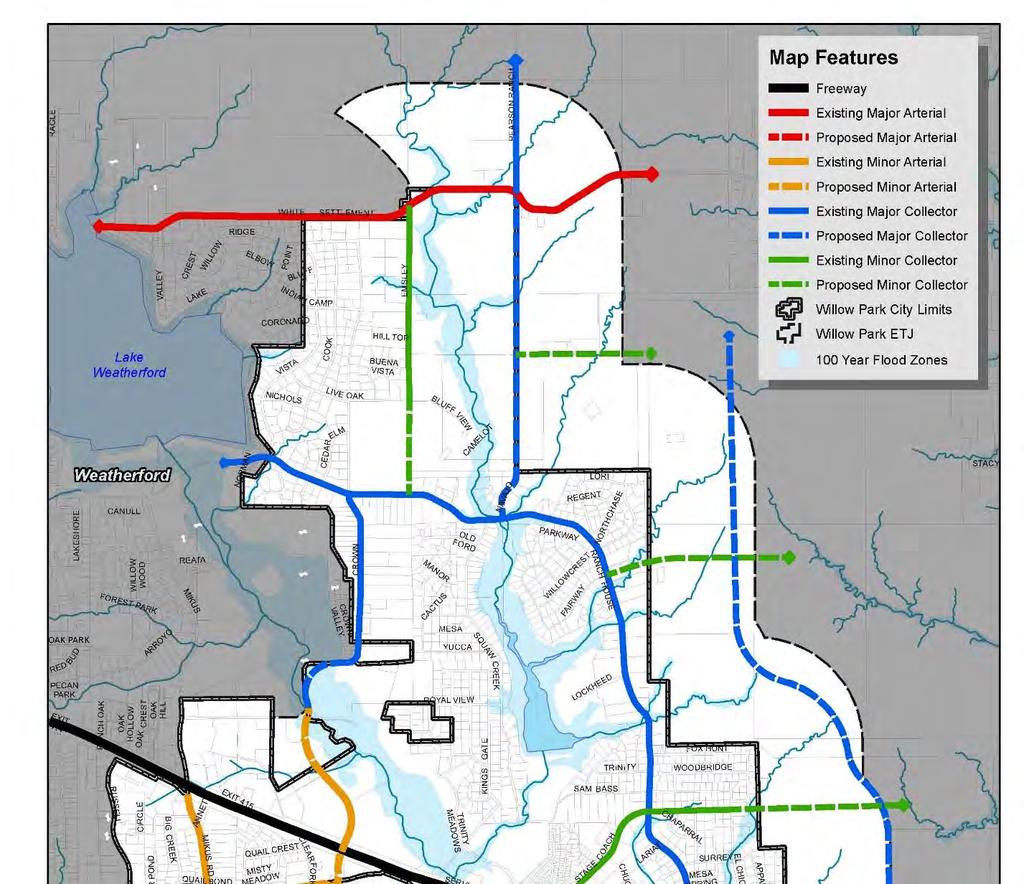
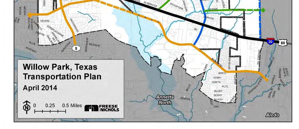
59 Thoroughfare Plan Map Thoroughfare Plan 53

60 Design Considerations Roadways in Willow Park will be designed to be safe, attractive and efficient. The following principles will be considered as roadways are constructed or improved, as new subdivisions are platted and as new site plans are approved. Access Management Access Management is used to improve both the safety and appearance of corridors. Access Management ensures that ingress and egress to a particular site is coordinated with traffic patterns of adjacent sites, viewing the corridor in its entirety rather than each separate business autonomously. Shared driveways are one of the most prominent features of access management. Shared driveways encourage adjacent businesses to share a single entrance rather than two separate entrances. Shared driveways are enabled through the creation of shared access easements that allow efficient vehicular circulation between two separate properties without having to access the main road. Additional forms of access management include cross access considerations where median cuts coincide with entrances on opposite sides of the main roadway. In high traffic areas, this configuration would be supported with a 4 way stop or signalization. Thoroughfare Plan Access Management is regulated in Willow Park s subdivision ordinance through cross access easements or shared access easements. Access Management reduces the number of points where vehicles are entering and exiting the main roadway, thereby reducing traffic collision potential. The reduction of driveway entrances also allows for more continuous landscaping areas, which improves corridor aesthetics. Access Management Components 54


61 Complete Streets A complete street utilizes roadway right of way to accommodate multiple forms of mobility. Incorporation of additional mobility options, such as separate walk/bike trails and sidewalks, enhance community connectivity. Bike routes and bike paths are some of the design features being most included by communities implementing Complete Streets. Complete Streets would best be utilized in Willow Park s Town Center by connecting entertainment uses to adjacent neighborhoods and outdoor recreational facilities and trails. Complete Street Car, Bicycle Path and Sidewalk Rural Character Roadways often represent the largest public space in terms of acreage. Roadways within Willow Park will contribute to the City s look and feel. Willow Park s large lot residential neighborhoods make the community more rural in nature. Rural design characteristics will be included during roadway improvement projects. Examples of rural design characteristics that can be used by willow Park would include continued use of curb and gutter drainage systems in low density areas. The use of fencing, particularly open fencing, complements rural characteristics. Lighting poles, decorative bridges, stop signs and other roadway signage could include special antique or rural designs that help to solidify Willow Park s identity. The use of such design features would be most appropriate along Ranch House Road, Mikus Road and Bankhead Highway. Rural Design Characteristics Thoroughfare Plan 55
62 Thoroughfare Plan 56


63 Neighborhood Livability What does the term livability mean with regard to urban planning? Generally, livability reflects the characteristics, aesthetics, design and social aspects of Willow Park that make the City unique, and which help to establish a sense of community. There are many intangibles that make a place livable, such as a sense of community, a strong sense of place, civic pride and the quality of neighborhoods. There are also tangible aspects that can nurture livability as well. Willow Park is a unique community with its own values and vision. The following section describes in more detail some of those tangible aspects that, when tailored to fit the needs and vision of Willow Park, can help the City to grow in a manner that enhances the quality of its neighborhoods and helps to create vibrant retail areas. This section is intended to be used to guide decision makers with what the public believes the character of Willow Park should be as it grows. Creating Places Where People Want to Be Livability Guidelines Preserve small town, rural feel Maintain open spaces that create a quiet, open feel Provide large lot homes Raise the bar on development/ attract quality development Attract neighborhood services Build a system of connected parks and trails for outdoor recreation Clearly brand and identify Willow Park through gateways and other identifying features Provide entertainment venues for families Create a high quality mixed use center where residents may shop, dine, socialize and live Neighborhood Livability Supports a Strong Sense of Community Encourages Reinvestment Keeps Taxes Lower 57

.")
 incorporates a number of design features to encourage connectivity and facilitate active neighborhoods.")
64 Current Planning Trends The following are planning trends applicable to WillowPark. Mix Land Uses A variety of land use types contributes to a neighborhood s walkability and vibrancy. Providing a mix of land uses increases pedestrian activity and helps to create a sense of place within the community. Mixed land uses can come in the form of vertical mixed use (typically retail at ground level and office and/or residential on upper levels), or horizontal mixed use (each use is contained within its own structure but planned into a single development). It is desired for mixed use development to be encouraged within the Willow Park Town Center district particularly through the addition of retail and eating establishments. Neighborhood Livability Traditional Neighborhood Design Traditional Neighborhood Design (TND) incorporates a number of design features to encourage connectivity and facilitate active neighborhoods. Examples of several TND design features include: Connected street grid; Reduced housing setbacks from the street; Front porches; Neighborhood pocket parks; Distinctive architectural design elements; Sidewalks and pedestrian integration; Various housing sizes; and Neighborhood centers accessible by car and foot. The advantages of TND will continue to be explored within Willow Park, particularly in areas around the Town Center. TND would help to keep the small town feel desired by residents, while providing quality housing choices. 58


65 Full Life Cycle Create a Range of Housing Opportunities and Choices A range in housing options is important to ensure that full life cycle housing is available to enable residents to stay within the community throughout their lives, even as housing desires change. Smaller starter homes, larger homes, apartments, townhomes, and retirement facilities are important to ensure adequate housing for young adults, families with children, empty nesters and retirees. Adult Living Complex Assisted Living Empty Nester Multiple Family Move up Home Starter Home Create Walkable Centers Walkable neighborhoods are residential and nonresidential areas designed to be pedestrian friendly through the use of sidewalks, signage, connectivity, seating, landscaping, and lighting. This type of design helps to establish a sense of place and identity. In Willow Park, walkability is desired and will be a primary design component within the Town Center. Foster Distinctive, Attractive Communities with a Strong Sense of Place A challenge for communities located in metropolitan areas is distinguishing themselves from adjacent communities. Aesthetic appearance and improvements, when combined with community branding, will help to make Willow Park distinguishable from its neighbors. Additionally, neighborhoods with detailed building design, streetscaping, and amenities create local character and charm, which helps to maintain property values over time. Design characteristics in Willow Park will help to maintain the small town feel and atmosphere. Walkable Center Community Farmers Market Neighborhood Livability Preserve Open Space, Farmland, Natural Beauty, and Critical Environmental Areas A defining feature of Willow Park is its rural character. Open spaces, farms, rolling hills and riparian floodplains are significant community assets. Limiting development within floodplains and other environmentally sensitive areas preserves natural drainage systems and ecosystems. Preservation of open space and natural beauty can be accomplished through clustered housing developments or public acquisition of mature woodlands. Natural areas that are either purchased or acquired by easement can be utilized for both active and passive recreational activities by providing the public with natural areas, parks, recreational fields and hike/bike trails. Willow Park s Rural Environment 59


66 Provide a Variety of Transportation Choices Transportation variety generally evokes images of light rail and bus public transit service, but it can also refer to pedestrian connectivity, bike lanes and park andride/carpool facilities. Mobility alternatives, such as bike and pedestrian facilities, will help to enhance the quality of life in Willow Park by providing recreational options for residents. Walk and Bike Trail Neighborhood Livability Make Development Decisions Predictable, Fair, and Cost Effective Ease of development processes can have a major impact on the type of developments that Willow Park will attract. Zoning and subdivision processes should be clear, streamlined, and readily available. Development controls should be fair to the developer and result in development that is desirable by the citizens. Providing fair and plan based decisions to developers will help to make Willow Park attractive to those looking to invest within it. Encourage Community and Stakeholder Collaboration in Development Decisions First, citizens are encouraged be engaged in all community planning efforts to ensure that decisions made by City leaders, even as councils and commissions change, are rooted in the community s vision. Second, stakeholders, primarily developers, should be involved in the review of development regulations to ensure that standards and processes are reasonable and fair to developers, while reflecting the community s vision. Third, City staff should assume responsibility for coordinating and encouraging collaboration between these different groups. Fair Decisions Foster Development Community Engagement 60


67 Community Character The following are community design strategies that will be utilized as development decisions are made. These strategies are typically codified within the zoning and subdivision ordinances and will help Willow Park continue to be attractive and identifiable. The major community design element will be the preservation of Willow Park s small town feel. Willow Park Neighborhood Signage A method of enhancing the overall image of Willow Park is sign regulations to reduce the visual clutter that can result from a lack of regulation. Because of Willow Park s location along Interstate 20, many of the businesses along the corridor use pole signs to make their establishments visible to passing high speed traffic. Other areas of the community, however, are encouraged to restrict the use of pole signs for advertising. It is recommended for Willow Park to create and adopt a sign ordinance setting standards for pole signs along Interstate 20 with considerations for maximum height maximums of 40 to 50. Additionally, pole signs will be prohibited along Ranch House Road, Crown Point Boulevard, Crown Point Road, and Mikus Road. Monument signs will be used as a replacement for pole signs. Finally, consolidation of signage for shopping centers containing multiple tenants will be encouraged. Monument Sign Multiple Tenant Sign Neighborhood Livability 61


68 Screening The purpose of screening and buffering is to enhance the visual appearance of the community by separating incompatible land uses, improving the appearance of parking areas and public rights of way, minimizing soil erosion, and reducing Stormwater runoff. Screening typically focuses more on the visual impacts of the use while buffering focuses more on light and sounds. There are many techniques for screening and buffering. Types of screening include fences, walls, trees, or large shrubs that are placed strategically to help blend the use into the surrounding environment or block it completely. Natural screening includes strips of land such as hills or berms, clumps of trees and shrubs, or other landscape features that are used to reduce headlights glare and traffic noises. The following screening techniques will be considered: Masonry Screening Wall Screening of Utilities Neighborhood Livability The use of 8 masonry walls where residential and non residential areas abut. Masonry is more durable and requires less maintenance than wood fences; Use of trees along the line between the residential and non residential use, particularly if parking lighting is present, to help mitigate lighting impacts; Screening of trash receptacles through a masonry or brick wall; Screening of loading docks, when present, through the use of walls, berms and landscaping; and Use of screening walls to hide commercial outside storage areas from the public view and abutting residential areas. Natural Screening Wall 62


69 Landscaping Landscape requirements enhance the view and image of the City, particularly along Interstate 20, Ranch House Road and Crowne Point Boulevard. Nonresidential landscaping requirements should consider the following: Minimum landscape buffer width of 10 along Ranch House Road and Crowne Point Road and 20 along Interstate 20; One 3 caliper tree every 40 feet of street frontage; The use of native landscaping to reduce water use, when possible; Low Impact Design (LID) landscaping techniques to retain and absorb a portion of a sites Stormwater runoff; and Landscaped islands in parking areas over 30 spaces in size. Landscaping Along Crown Point Boulevard Building Materials Building material regulations in non residential areas are important to enhance the aesthetic value of the community and to establish cohesiveness and continuity throughout the City. Quality building materials enhance the visual perception over the long term and reduce maintenance and upkeep. Quality materials may include, but are not limited to: Limestone (or other stone) Brick Stucco HardiPlank It is desired for metal buildings, in particular, to utilize 100% masonry on all street frontages. Building Articulation Building articulation helps to enhance the aesthetic value of non residential development. Horizontal and vertical articulations help to break a building plane and typically require the building plane to be offset either vertically or horizontally. Articulation is typically mandated in the zoning ordinance, but additional overlays or design ordinances may be created for specific areas, such as the Interstate 20 corridor or the Town Center area. Use of Masonry and Brick Façade Use of Horizontal and Vertical Articulation Neighborhood Livability 63


70 Street Character Willow Park s roadway design standards, particularly in areas outside of the Town Center, will reflect the community s rural character and feel. The following will be considered for roadway design along Ranch House Road, Crown Road and Bankhead Highway: White, wooded fences; Open iron segments on subdivision masonry walls; and Minimal use of curb and gutter system through residential estate areas. Open Iron Segment in Neighborhood Perimeter Wall Neighborhood Livability Walkability Encouraging walkability within the community begins with ensuring that sidewalks and pathways are viewed as a necessity rather than an amenity. The following walkability guidelines will be considered: Sidewalks will continue to be required as a component of non residential site plan approval. Sidewalks will be a minimum of 4 in width; Sidewalks along Crown Point Boulevard will be a minimum of 6 in width to enhance the walkability within the Town Center; Areas near schools and other public facilities wil receive priority for implementation of contiguous sidewalks and Safe Routes to School grant funding will be explored; and Pedestrian amenities will be encouraged, particularly within the Town Center. Pedestrian amenities include public benches, pedestrian scale lighting, shade trees, art, enhanced sidewalks, refuse containers and other elements which enhance the safety and ease of pedestrian circulation. Crosswalk and Shade Trees Enhancing the Pedestrian Environment. Connectivity New development within Willow Park will focus on integration of land uses ensuring that development contains connections, both vehicular and pedestrian in nature, to adjacent land uses. The following strategies will aid in improving overall community connectivity: Encourage multiple street connections between adjacent developments by encouraging a minimum of two street connections in new subdivisions; Ensure that neighborhoods provide access to parks and trails, when present; Working with developers to incorporate parks and trails as development occurs, either through easement, land dedication or purchase; Provide sidewalks in developments that are greater than 4 dwelling units per acre in density; Ensure that residential areas within the Town Center are integrated with and provide connections to retail, entertainment and recreational areas; Provide multi modal facilities, such as trails and bike paths through Clear Fork floodplain areas; Explore creating a recreational pathway under Interstate 20 at the Clear Fork of the Trinity River. 64


71 Gateways Gateways are features, landmarks or other streetscape elements that help to create an identity, orient visitors to an area and signify entrance to the City. Two distinct classes of gateway entries will be implemented and include regional gateways and entry portals. Community Entry Gateways Regional Gateways are located at key locations and are large in scale and contain recognizable features which identify Willow Park. Typical elements include, but are not limited to, monuments, interior and/or exterior lighting, accentuating landscape and possible water features. Key locations for regional gateways are along Interstate 20, particularly at Ranch House Road and/or Crown Point Boulevard. Entry portals are typically located at major and secondary points into the city and are intended to create identity at the city street level. These features will be designed with a unified theme to enhance continuity and link elements to gateway features creating a recognizable community identity. Key locations for entry portals in Willow Park are: E. Lake Drive White Settlement Road Bankhead Drive Mikus Road Branding Branding is a key component to establishing community identity. A committee of residents, businesses and leaders will be created and a community theme will be established. Willow Park s theme will be reflective of its small town nature and rural character and would guide the following elements: Signage Toppers and Subdivision Entry Features Provide Community Branding Neighborhood Livability Community signage; Entry features and gateway elements; Non residential design elements; Roadway character (i.e., fences and other aesthetic elements); Intersection enhancements and decorative lighting; and Town Center design. 65

72 Community Trails A defining feature of Willow Park is its open spaces, rural characteristics and floodplain areas. Additionally, a significant ridge exists along the eastern side of the community providing scenic vistas of Willow Park and beyond. As the community develops, these assets will be protected and utilized. Rural Characteristics in Northern Willow Park Neighborhood Livability The trail network is an opportunity to provide outdoor recreational options for residents. The trail network is a combination of on street and off street facilities and implementation will require the City to work together with developers and private property owners. Ultimately, the purpose of the trail network is to connect various areas of Willow Park together and to provide recreational options that preserve and utilize Willow Park s assets. Off Street Trails Off street trails are those that are separated from roadways. These trails are located primarily along riparian systems. Incorporating trails through these riparian systems protects the natural environment near streams and provides scenic recreational opportunities for residents. Off street trails will generally be dirt surface facilities but concrete or asphalt facilities may be desired in areas of heavy usage, such as near the Town Center and the southern portions of Squaw Creek Golf Course. Bicycle Friendly Facilities Street connections will be required to connect the various off street trail elements. These roadways are intended to be safe corridors for pedestrians and bicyclists as they utilize the City s trail network. Squaw Creek Road should be a bicycle friendly corridor connecting two off street trail elements. The street will contain markings that indicate pedestrians and bicyclists may be present and will contain guiding signage for pedestrians and bicyclists. Additionally, Bankhead Drive is currently utilized by longdistance bicyclists. Signage will indicate the presence of bicyclists and roadway improvements will consider a wide shoulder for use by bicyclists. Ridge Trail The Ridge Trail is intended to be an off street trail facility. Its implementation will likely occur incrementally in conjunction with development. The City will work with developers to reserve or obtain land through easement or dedication. The intent of the trail is to provide periodic vistas as it traverses the eastern side of Willow Park. 66

73 Trail Plan Map Neighborhood Livability 67


74 Housing Strategies The following section provides some general criteria that will be considered during the development review process. These strategies, when possible, will be codified within the zoning and subdivision ordinances. In addition to providing strategies for design of future neighborhoods within Willow Park, strategies to maintain existing neighborhoods and mitigate decline are also provided. Neighborhood Livability Neighborhood Design Neighborhoods are often defined in more abstract terms by the sense of community and the quality of life enjoyed by the people who live and play there. Well designed neighborhoods provide a setting for residents to develop a strong sense of belonging, which is promoted by their interactions. The quality and livability of the City s neighborhoods are integral components of the overall character. The key to a successful neighborhood is creating a sustainable environment where the ongoing investment in property is supported by public investment in parks and greenbelt areas; opportunities for social interaction; accessibility for pedestrians, bicyclists and vehicles; and distinctive characteristics which give an area a unique identity. Neighborhoods may be quantified in terms of the following characteristics: Opportunities for social interaction. Careful and strategic placement of nonresidential uses so as not to negatively impact the attractiveness of neighborhoods and utilizing screening and buffering to mitigate any land use conflicts. Continued investment in public and private property to stabilize property values. Condition of public facilities and infrastructure serving the area. A sense of community and belonging among residents through distinctive neighborhood identities. Access to amenities such as parks, open spaces, public facilities and trails. 68


75 New Neighborhood Recommendations The following strategies will be considered in the design of future neighborhoods in Willow Park. Local street connections should be encouraged between adjacent subdivisions. Cul de sac s should be limited to no longer than 600 feet. Housing orientation should front public parks and open spaces to ensure the accessibility to these areas by the public. Street and pedestrian connections should be made between low density residential areas and areas of medium density residential and neighborhood retail. Pathways and trails should link residential areas to non residential areas providing convenient pedestrian access. Encourage trees to be planted at a distance of feet along both sides of residential streets; Consider rear entry garages in developments with lots less than 50 feet in width to enhance street appearance. Consider J Drives or other garage arrangements to hide garage entrances from public view. Consider constructing ribbon curbs instead of raised curbs in appropriate areas to naturally absorb storm water runoff, particularly when open drainage is used. In developments over 4 dwelling units an acre in density, require the provision of sidewalks. When development occurs adjacent to the trails plan, require a neighborhood access point to be depicted on the site plan. Consider neighborhood entrance features constructed primarily of masonry materials. Consider the use of enhanced lighting fixtures within residential areas. Encourage the formation of neighborhood associations in new subdivisions for neighborhood maintenance and upkeep. Encourage various lot and housing sizes within new subdivisions. Innovative Neighborhood Design Innovative design principles will be encouraged by developers to avoid monotony in design. Examples of innovative design concepts that will be encouraged in new developments include the following: Traditional Neighborhood Design (TND) Clustering to preserve open space Varied lot sizes and home sizes Connected streets Integrated parks and trails Roadway meandering coinciding with topographic variations Preservation of view sheds Connectivity Between Residential Subdivision and Retail Node Neighborhood Livability 69


76 Neighborhood Livability Existing Neighborhood Strategies The following strategies will be considered in existing neighborhoods to mitigate the impact of neighborhood decline and encourage continued property maintenance and investment. Code enforcement and compliance to maintain visible integrity of existing Existing Housing in Willow Park neighborhoods. Addition of parks, trails and public open spaces that continue to make neighborhoods attractive and encourage upkeep and maintenance. Maintenance of public infrastructure, such as roadways, water and wastewater infrastructure. Compatibility of adjacent nonresidential development ensuring that new development adjacent to neighborhoods makes a good neighbor (i.e., does not generate significant noise or lighting and screens loading areas, trash receptacles and outside storage areas). Property maintenance programs that aid residents in the upkeep and maintenance of homes and counter neighborhood decline. Volunteer assistance, such as youth and non profit organizations, to aid in property maintenance for those not able to do so. Housing Types and Categories The following are the types of housing that are appropriate for Willow Park. While multifamily and mixed use residential options are provided, the vast majority of housing within the community is expected to remain low density single family development that preserves Willow Park s rural and open feel. Residential Estate (R 1) The residential estate category will represent large lot single family options that are generally one acre in size or larger. The majority of residential estate will be confined to the far northern side of Willow Park. Residential Estate uses will help to preserve the small town rural feel of Willow Park and will provide options for future residents seeking that lifestyle. Rural Characteristics in Northern Willow Park 70

 High density residential generally takes the form of multifamily developments.")

77 Single Family Residential (R 2, R 3) This category refers to single family homes that are generally included in typical subdivisions. This type of housing currently composes a large portion of Willow Park s existing housing stock. In terms of development density, low density is reflective of approximately one to four dwelling units per acre and medium density is reflective of 4 8 dwelling units per acre. Lot sizes will range from about 6,000 square feet to a half acre. Multifamily (MF 1, MF2) High density residential generally takes the form of multifamily developments. Traditionally, multifamily developments range in density from 8 16 dwelling units per acre. Multifamily developments allow for a full life cycle of housing. The addition of amenities, such as garages, clubhouses and pools, among others, help to raise the bar on quality and make multifamily developments more stable in the long term. Mixed Use (MU) The Town Center of Willow Park will be mixed use in nature. Among the many non residential uses, there will likely be a range of residential uses. The residential uses within the Town Center may include apartments, urban lofts (live above units) and townhomes/ brownstones. The addition of medium density and multifamily areas within the Town Center will help to create continuous activity and will provide a live, work and play environment for those seeking such options. Neighborhood Livability 71
CITY OF COLWICH COMPREHENSIVE PLAN LAND USE LAND USE 1
 LAND USE LAND USE 1 WHAT YOU WILL FIND IN THIS CHAPTER: Discussion of today s conditions and tomorrow s projections Discussion of challenges and opportunities Discussion of the environmental quality goals,
City of Melissa Comprehensive Plan Update
 City of Melissa Draft: April 1, 2015 TABLE OF CONTENTS Chapter 1: Existing Conditions Analysis Introduction... 1.1 Demographic Characteristics... 1.3 Housing Characteristics... 1.22 Land Use Characteristics...
Secrest Short Cut and Monroe Expressway Small Area Plan AUGUST 29, 2018
 Secrest Short Cut and Monroe Expressway Small Area Plan AUGUST 29, 2018 Background and Process Monroe Expressway will be open by the end of 2018 Union County and Indian Trail identified a need to revisit
2.0 AREA PLANS. Lakeside Business District. Lakeside Business District Land Use Categories:
 Lakeside Business District Lakeside Business District Land Use Categories: Campus Commercial Campus Commercial means a mixture of uses which includes corporate offices, office parks, hotels, commercial,
Implementation Guide Comprehensive Plan City of Allen
 Implementation Guide 2030 Comprehensive Plan City of Allen DRAFT 2015 Implementation Guide Allen 2030 Comprehensive Plan INTRODUCTION The Comprehensive Plan serves as a guide for the growth and development
The transportation system in a community is an
 7 TRANSPORTATION The transportation system in a community is an important factor contributing to the quality of life of the residents. Without a sound transportation system to bring both goods and patrons
Gold Line Bus Rapid Transit Transit Oriented Development (BRTOD) Helmo Station Area Plan
 Helmo Station Area Plan") Appendix F Gold Line Bus Rapid Transit Transit Oriented Development (BRTOD) Helmo Station Area Plan Introduction and Purpose of the Plan The Gold Line Bus Rapid Transit facility is an eleven-mile dedicated
Appendix F Gold Line Bus Rapid Transit Transit Oriented Development (BRTOD) Helmo Station Area Plan Introduction and Purpose of the Plan The Gold Line Bus Rapid Transit facility is an eleven-mile dedicated
EXECUTIVE SUMMARY DRAFT CHAPTER 1 INTRODUCTION EXECUTIVE SUMMARY
 CHAPTER 1 EXECUTIVE SUMMARY INTRODUCTION Through the joint efforts of the City of Tulsa planning staff and the Land Services division of Indian Nations Council of Governments (INCOG), the Berryhill Land
Ten Mile Creek Planning Area
 PLANNING AREA POLICIES TEN MILE CREEK Ten Mile Creek Planning Area Location and Context The Ten Mile Creek Planning Area ( Ten Mile Creek area ) is located south of the current Boise AOCI, generally south
Comprehensive Plan. Faribault, Minnesota. Hoisington Koegler Group Inc. Claybaugh Preservation Architecture Inc. Howard R. Green Company Bonz/REA
 Comprehensive Plan Faribault, Minnesota Adopted by the Faribault City Council July 8, 2003 prepared for: prepared by: Hoisington Koegler Group Inc. Claybaugh Preservation Architecture Inc. Howard R. Green
5 Land Use Element49
 5 Land Use Element 49 City of Forney - Comprehensive Plan Land Use Introduction Forney s Comprehensive Plan is a guide for physical and economic development in the City of Forney over the next 20-years.
Joint Meeting City Council and the Plan Commission. September 1st, 2015
 Joint Meeting City Council and the Plan Commission September 1st, 2015 1 The City Plan Commission shall recommend a City Plan for the physical development of the City Article IX Section 2 of the City of
Definitions. Average Daily Traffic Demand (ADT): The actual number or projected number of cars that pass a point in a 24-hour period.
: The actual number or projected number of cars that pass a point in a 24-hour period.") Definitions Access Management: A combination of physical techniques and transportation policies used to control the flow of traffic between roads and the surrounding lands. Alternative City Form Scenarios:
Definitions Access Management: A combination of physical techniques and transportation policies used to control the flow of traffic between roads and the surrounding lands. Alternative City Form Scenarios:
Port Lavaca Future Land Use
 Port Lavaca Future Land Use Introduction The City of Port Lavaca is beginning to see sustained growth, after many years of relative stable population. New single family homes, apartments, and businesses
CHAPTER 7: Transportation, Mobility and Circulation
 AGLE AREA COMMUNITY Plan CHAPTER 7 CHAPTER 7: Transportation, Mobility and Circulation Transportation, Mobility and Circulation The purpose of the Transportation, Mobility and Circulation Chapter is to
Purpose of the Master Plan
 Purpose of the Master Plan 4 Master Plan Purpose The Master Plan is a policy framework for decisions that affect the physical, social and economic environment of the Town. The Parker 2035: Master Plan
Scope of Services. River Oaks Boulevard (SH 183) Corridor Master Plan
 Corridor Master Plan") Scope of Services River Oaks Boulevard (SH 183) Corridor Master Plan PROJECT AREA The project area consists of the River Oaks Boulevard (SH 183) corridor bounded by SH 199 at the northern end and the Trinity
Scope of Services River Oaks Boulevard (SH 183) Corridor Master Plan PROJECT AREA The project area consists of the River Oaks Boulevard (SH 183) corridor bounded by SH 199 at the northern end and the Trinity
CHAPTER 1. Ms. Guajardo s Class - Central Elementary CH 1 1
 INTRODUCTION CHAPTER 1 Ms. Guajardo s Class - Central Elementary CH 1 1 1.1 SETTING South Centre City is a linear corridor south of Downtown Escondido paralleling Centre City Parkway and South Escondido
COLVER ROAD INDUSTRIAL CONCEPT PLAN
 COLVER ROAD INDUSTRIAL CONCEPT PLAN A CONCEPTUAL LAND USE AND TRANSPORTATION PLAN FOR TA-4 AN URBAN RESERVE AREA OF THE CITY TALENT City of Talent Adopted by City Council Resolution No., June, 2015 PART
1.0 Introduction. Purpose and Basis for Updating the TMP. Introduction 1
 1.0 Introduction The Town of Castle Rock is situated between the metropolitan areas of Denver and Colorado Springs, amidst a unique terrain of rolling hills, mesas, ravines, and waterways. Like many Front
4.1.3 LAND USE CATEGORIES
 4.1.3 LAND USE CATEGORIES a. City Center District The City Center District incorporates the existing character and mix of uses in downtown Belmont to encourage redevelopment and new development in keeping
SECTION ONE: INTRODUCTION. introduction
 introduction 1 INTRODUCTION Since it was first established in 1843 as a trading post for the Hudson s Bay Company, Victoria has evolved into a Provincial capital city that is recognized across Canada and
CHAPTER 7: VISION AND ACTION STATEMENTS. Noble 2025 Vision Statement
 CHAPTER 7: VISION AND ACTION STATEMENTS This chapter presents the vision, policy and action statements that transform the comprehensive planning study, an analysis of Noble s past, future trends and community
CHAPTER 3 VISION, GOALS, & PLANNING PRINCIPLES. City of Greensburg Comprehensive Plan. Introduction. Vision Statement. Growth Management Goals.
 CHAPTER 3 VISION, GOALS, & PLANNING PRINCIPLES Introduction The Greensburg Comprehensive Plan is intended as a working community document. A combination of long and short-term goals, this document is intended
7Page 1 CLEMMONS COMMUNITY COMPASS 1 PLAN OVERVIEW
 1 Plan Overview WHAT IS I THE CLEMMONS COMMUNITY COMPASS? The Clemmons Community Compass is our community s comprehensive plan. It serves as our blueprint and provides direction for the future of the Village
I-35 CORRIDOR VISION PLAN INTRODUCTION. Purpose. Background
 INTRODUCTION Purpose The Interstate 35-E Corridor Plan is intended to work conjunctively with the 2010 Red Oak Comprehensive Plan to promote positive and quality development and redevelopment along Interstate
DEVELOPMENT FRAMEWORK POST 2030 LAND USE PLAN INTRODUCTION
 INTRODUCTION Oak Grove s Comprehensive Plan identifies a future Metropolitan Urban Service Area (MUSA). The Metropolitan Council does not anticipate extending utilities to this area prior to 2030. The
Comprehensive Development Guide
 INDUSTRIAL ELEMENT Comprehensive Development Guide 1 Industrial Element 7.1 Hardin County Industrial Overview BG PKWY Fort Knox Industrial Corridor Comprised of 11 parcels totaling 720 acres of land 68
9 th Street Sub Area Plan
 9 th Street Sub Area Plan In the 1990 s, when the Township prepared the last Master Plan, the 9 th Street corridor was studied as part of a larger 9 th Street Focus Area that included the West Main Street
Purpose of the Master Plan
 Purpose of the Master Plan 4 Master Plan Purpose The Master Plan is a policy framework for decisions that affect the physical, social and economic environment of the Town. The Parker 2035: Master Plan
LAND USE ELEMENT. Purpose. General Goals & Policies
 LAND USE ELEMENT Purpose This Land Use Element contains the goals and policies necessary to support the City s responsibility for managing land resources and guiding development through implementing regulations,
A. WHAT IS A GENERAL PLAN?
 I. Introduction A. WHAT IS A GENERAL PLAN? A general plan is the planning guideline for the future of a city. It contains goals and policies which regulate urban development, the protection of the natural
TRANSPORTATION AND LAND USE
 CHAPTER 10 TRANSPORTATION AND LAND USE Transportation and land use are intimately linked. The expansion of a highway typically spurs housing, employment growth and land development in the communities that
IMPLEMENTATION STRATEGIES. In This Chapter. Goals & Strategies 182 Project List 183 Future Land Use 186 CHAPTER 11 IMPLEMENTATION STRATEGIES
 In This Chapter Goals & Strategies 182 Project List 183 Future Land Use 186 11 IMPLEMENTATION STRATEGIES NORTH AUGUSTA, SC 2017 COMPREHENSIVE PLAN 179 Individual commitment to a group effort that is what
Woodburn Comprehensive Plan Growth Management Goals and Policies
 Goal Woodburn Comprehensive Plan Growth Management Goals and Policies G-1. The City's goal is to manage growth in a balanced, orderly and efficient manner, consistent with the City s coordinated population
Planning Districts INTRODUCTION
 INTRODUCTION To facilitate detailed examination of development prospects for all areas of the community, Delano has been divided into 14 planning districts. The location of these planning districts is
Section 9 NEIGHBORHOOD DESIGN
 Section 9 NEIGHBORHOOD DESIGN City of Lancaster Comprehensive Plan D u n k i n, S e f k o & A s s o c i a t e s, I n c. NEIGHBORHOOD DESIGN INTRODUCTION There are many ways in which a neighborhood can
2040 LUP is a part of the Comprehensive Plan and carries the same legal authority. Economic Challenges
 1.1. Guiding Anchorage s Growth Where will new residents settle over the next two decades? Where will people work, shop, and play? Will there be enough room to grow? How will Anchorage look? Will growth
LAND USE OVERVIEW WHAT YOU WILL FIND IN THIS CHAPTER
 LAND USE WHAT YOU WILL FIND IN THIS CHAPTER Information about the City s expected population and employment growth. Description and capacity of existing and future land use designations. Policies that
Economic Development & Housing Council Committee Comprehensive Plan Update September 20, 2005
 1 Economic Development & Housing Council Committee Comprehensive Plan Update September 20, 2005 Purpose To update the Committee on the ForwardDallas! Plan, including: Status Anticipated Products Public
The West Vaughan Employment Area Secondary Plan Policies
 Part 2: The West Vaughan Employment Area Secondary Plan Policies 2.1 General Policies It is the policy of Council: 2.1.1. That the West Vaughan Employment Area (the WVEA), identified on Schedule 1, will
1.0 INTRODUCTION 1.1 TH 14 WEST STUDY AREA Project Description Functional Classification Purpose of the Project
 1.0 INTRODUCTION 1.1 TH 14 WEST STUDY AREA 1.1.1 Project Description The Trunk Highway (TH) 14 West Corridor is a two-lane roadway approximately 22 miles in length. Located in Nicollet County, the corridor
3.0 PROJECT DESCRIPTION
 3.0 PROJECT DESCRIPTION 3.1 BACKGROUND Under California law (Government Code Section 65300 et seq.), every city and county is required to have a general plan. The general plan is to be comprehensive and
Corridor Vision. 1Pursue Minnehaha-Hiawatha Community Works Project. Mission of Hennepin County Community Works Program
 1Pursue Minnehaha-Hiawatha Community Works Project Minnehaha-Hiawatha Community Works is a project within the Hennepin Community Works (HCW) program. The mission of the HCW program is to enhance how the
IH35 Corridor Plan Amendment to the Comprehensive Plan
 IH35 Corridor Plan Amendment to the Comprehensive Plan Background The corridor plan for the IH35 corridor is an amendment to the Burleson comprehensive plan. Generally, the purpose of a corridor plan is
Section 7 FUTURE LAND USE PLAN
 Section 7 FUTURE LAND USE PLAN City of Lancaster Comprehensive Plan D u n k i n, S e f k o & A s s o c i a t e s, I n c. FUTURE LAND USE PLAN INTRODUCTION Land can be viewed as a shared natural resource,
SALISBURY TOMORROW Our Vision
 SALISBURY TOMORROW Our Vision Salisbury is committed to supporting a high quality of life and sense of community for all residents. These commitments need to be reflected in our community programs, services
POCKET COMMUNITY PLAN
 POCKET COMMUNITY PLAN Part Three : COMMUNITY PLAN AREAS AND SPECIAL STUDY AREAS CONTENTS Community Location... 3-P-3 Community Vision... 3-P-4 Community Profile... 3-P-4 Community Issues... 3-P-6 Land
LAND USE TANGLEWILDE/THOMPSON PLACE PLANNING AREA. C. Identified Neighborhood Groups and Homeowner s Associations
 LAND USE TANGLEWILDE/THOMPSON PLACE PLANNING AREA I. Profile of Tanglewilde/Thompson Place Planning Area (Revised 3/5/02) A. Location The Tanglewilde/Thompson Place Planning Area is located just east of
IH35 Corridor Plan Amendment to the Comprehensive Plan
 IH35 Corridor Plan Amendment to the Comprehensive Plan Background The corridor plan for the IH35 corridor is an amendment to the Burleson comprehensive plan. Generally, the purpose of a corridor plan is
Chapter 1: Introduction
 Chapter 1: Introduction The Penn Avenue Community Works Corridor Vision and Implementation Framework presents an integrated communitybased vision and a coordinated, long-term implementation framework for
Mitchell Ranch South MPUD Application for Master Planned Unit Development Approval Project Narrative. Introduction
 Mitchell Ranch South MPUD Application for Master Planned Unit Development Approval Project Narrative Introduction Mitchell Ranch South is a proposed single family (detached) residential development on
Baumgarten MPUD. Exhibit 3 Evaluation Criteria
 Pursuant to LDC subsections 10.02.13 B, 10.02.08 F and Chapter 3 G. of the Administrative Code, staff s analysis and recommendation to the Planning Commission, and the Planning Commission s recommendation
6 Growth Management Challenges and Opportunities
 6 Growth Management Challenges and Opportunities The Town has established a goal of attaining a 50% participation rate with respect to employment opportunities versus residential population. The Town s
2. OVERALL POLICY DIRECTION
 Weatherford General Plan Overall Policy Direction 2. OVERALL POLICY DIRECTION 2-1 Draft - October 2017 CHAPTER 2: OVERALL POLICY DIRECTION A. ROLE OF OVERALL POLICY DIRECTION i. POLICY COMPONENTS A General
FUNDING CORRIDOR REVITALIZATION
 FUNDING CORRIDOR REVITALIZATION Integrated corridor planning for the 21 st Century America Planning Association Annual Conference Atlanta, GA April 27, 2014 Mariia Zimmerman, MZ Strategies, LLC mariia@mzstrategies.com
The Lower SaLuda Greenway
 The Lower SaLuda Greenway InITIaTIve a FLourIShInG Greenway. a hub For economic GrowTh. a ConneCTIon BeTween CoMMunITIeS. In April 2017 the Michael J. Mungo Foundation and Lexington County commissioned
TREASURE COAST REGIONAL PLANNING COUNCIL M E M O R A N D U M. To: Council Members AGENDA ITEM 5H
 TREASURE COAST REGIONAL PLANNING COUNCIL M E M O R A N D U M To: Council Members AGENDA ITEM 5H From: Date: Subject: Staff October 17, 2008 Council Meeting Local Government Comprehensive Plan Review Draft
Elm Fork Land Use. Trinity River Corridor Project Committee May 13, 2013
 Elm Fork Land Use Trinity River Corridor Project Committee May 13, 2013 Purpose Discuss Trinity River planned Land Use and Appropriate Compatible Uses, particularly with respect to the Elm Fork Area 2
DRAFT Subject to Modifications
 TREASURE COAST REGIONAL PLANNING COUNCIL M E M O R A N D U M To: Council Members AGENDA ITEM 8 From: Date: Subject: Staff May 19, 2017 Council Meeting Florida Department of Transportation Complete Streets
INTRODUCTION PLANNING HISTORY
 INTRODUCTION The Upper Rock Creek Master Plan Area lies in the east central part of Montgomery County. The Master Plan Area is adjacent to the City of Rockville to the south, the Olney Planning Area to
495/MetroWest Development Compact Plan Citizen Planner Training Collaborative Conference. March 17, 2012
 495/MetroWest Development Compact Plan Citizen Planner Training Collaborative Conference March 17, 2012 Project Process Local and Regional Priority Areas Growth Scenarios Transportation Investment Categories
REQUEST FOR QUALIFICATIONS
 REQUEST FOR QUALIFICATIONS VILLAGE OF HAMBURG COMPREHENSIVE ZONING/LAND USE REGULATIONS UPDATE Prepared By: Village of Hamburg 100 Main Street Hamburg, New York 14075 Village of Hamburg RFQ Page 1 of 10
Hockessin Community Redevelopment Plan
 Hockessin Community Redevelopment Plan 3.1 Introduction The Community Redevelopment Plan for the Village of Hockessin is the result of the people s vision for a distinct village center that serves as the
Asbury Chapel Subdivision Sketch Plan
 Asbury Chapel Subdivision Sketch Plan PART 1: PROJECT SUMMARY Applicant: NVR Inc. Project Size: +/- 76.13 acres Parcel Numbers: 02101112,02116101,02116112, 02116113 Current Zoning: Transitional Residential
Town Center (part of the Comprehensive Plan)
") Town Center (part of the Comprehensive Plan) Mercer Island Town Center Looking North (2014) In 1994, a year-long process culminated in a set of design guidelines and code requirements for the Town Center
Town Center (part of the Comprehensive Plan) Mercer Island Town Center Looking North (2014) In 1994, a year-long process culminated in a set of design guidelines and code requirements for the Town Center
Planning & Zoning Commission Staff Report
 Planning & Zoning Commission Staff Report Meeting Date: May 26, 2015 Drafted by: Katherine Harrison-Rogers CASE # Z2886 PROJECT NAME: APPLICANT/ REPRESENTATIVE: Shawna Runyan PROPERTY OWNER: 1840 (previously
Comprehensive Plan ADOPTED APRIL 2014
 Comprehensive Plan ADOPTED APRIL 2014 8 8. Outstanding Recreational & Cultural Opportunities We are proud of our community s parks and recreation system. Our community will ensure that the legacy of our
Introduction. Chapter 1. Purpose of the Comprehensive Plan Plan Organization Planning Process & Community Input 1-1
 Chapter 1 Introduction Lakewood 2025: Moving Forward Together Purpose of the Comprehensive Plan Plan Organization Planning Process & Community Input 1-1 Purpose of the Comprehensive Plan The Comprehensive
Citizen Comment Staff Response Staff Recommended Revision Planning Committee
 Citizen Comment Staff Response Staff Recommended Revision Planning Committee Area No. 1: Owner desires retail land uses. Area No. 1a: Owner of two small parcels adjacent to Area No. 1 desires retail land
Miami Valley Regional Planning Commission Regional Land Use Planning
 Miami Valley Regional Planning Commission Regional Land Use Planning This document provides an overall approach on the region-based land use planning process, outlining the major tasks and work elements
Living in Albemarle County s Urban Places
 Living in Albemarle County s Urban Places ALBEMARLE COUNTY, VIRGINIA A Closer Look at Albemarle s Approach to Managing Growth and Creating Quality Urban Environments www.albemarle.org Page 2 Living in
12/9/2013. HOLLYWOOD/PINES CORRIDOR PROJECT AMPO 2013 Annual Conference October 24, Our Perspective. Broward.
 HOLLYWOOD/PINES CORRIDOR PROJECT AMPO 2013 Annual Conference October 24, 2013 Our Perspective Broward Fort Lauderdale 1 Broward Metropolitan Planning Organization Fort Lauderdale Fort Lauderdale Skyline
ARLINGTON COUNTY, VIRGINIA
 ARLINGTON COUNTY, VIRGINIA County Board Agenda Item Meeting October 15, 2005 DATE: September 28, 2005 SUBJECT: Request to Advertise the adoption of the 2005 Clarendon Sector Plan C. M. RECOMMENDATION:
9 CITY OF VAUGHAN OFFICIAL PLAN AMENDMENT NO BOCA EAST INVESTMENTS LIMITED
 9 CITY OF VAUGHAN OFFICIAL PLAN AMENDMENT NO. 631 - BOCA EAST INVESTMENTS LIMITED The Planning and Economic Development Committee recommends the adoption of the recommendations contained in the following
Overview of the Plan. The Building Blocks of Centers, Neighborhoods and Network INTERNAL DRAFT
 Overview of the Plan 4 East Davidson Ramah Church Rd June Washam Rd Bradford District Park Bradford Shearer Rd Campus District NC 73 Davidson-Concord North Rocky River This Master Plan projects an approximate
4. ENVIRONMENTAL IMPACT ANALYSIS 7. LAND USE AND PLANNING
 4. ENVIRONMENTAL IMPACT ANALYSIS 7. LAND USE AND PLANNING 4.7.1 INTRODUCTION The following analysis discusses the consistency of the Proposed Project with the corresponding land use and zoning designations
Regional Context Statement
 Regional Context Statement REGIONAL CONTEXT STATEMENT 3. REGIONAL CONTEXT STATEMENT In 1995, the Provincial Government passed into law the Growth Strategies Act. The purpose of this provincial initiative
Plano Tomorrow Vision and Policies
 Plano Tomorrow Vision and Policies PLANO TOMORROW PILLARS The Built Environment The Social Environment The Natural Environment The Economic Environment Land Use and Urban Design Transportation Housing
Selected Area Study. Vision Plan Draft
 East Polk County Selected Area Study Draft 10.30.08 Contents Guiding Principles...4 Context Conclusions...5 Current Context...8 Scenarios...9 Scenario: Status Quo...10 Scenario: Connected & Directed Growth...12
City Council March 27, Parks, Recreation, and Trails Master Plan
 City Council March 27, 2018 Parks, Recreation, and Trails Master Plan Planning Process Develop Goals and Objectives Inventory of Areas and Facilities Needs Assessment And Identification Public Participation
2018 Northampton Township Comprehensive Plan
 2018 BUCKS COUNTY, PENNSYLVANIA What is a? A comprehensive plan is a municipality s main policy document that details the collective vision for the future, the historic, environmental, and cultural facilities
Sustainably Repositioning Greyfield Sites. Greyfield Sites Anywhere
 Sustainably Repositioning Greyfield Sites Jim Constantine Looney Ricks Kiss Architects Todd Poole 4ward Planning Greyfield Sites Anywhere Pennsylvania Chapter American Planning Association Conference 2009
The Trinity River Corridor, offering Dallas areas of natural
 IMPLEMENTATION PLAN FOR THE TRINITY RIVER CORRIDOR The Trinity River Corridor, offering Dallas areas of natural beauty and untapped potential, runs through the heart of the city. Proposed improvements
This chapter describes the purpose of the Plan, introduces how the Plan is organized and provides contextual background for the Plan.
 Chapter 1: INTRODUCTION Purpose of a Comprehensive Plan The 2040 Comprehensive Plan establishes Medina s vision as a community and sets goals and objectives which guide future decisions and policies. The
EXECUTIVE SUMMARY. Introduction
 EXECUTIVE SUMMARY Introduction State Route 68 is a designated scenic route that connects the world-renowned Monterey Peninsula to US Highway 101 and the Salinas Valley. SR 68 is a key route for bicycle,
Plan Goals. Protect existing residential neighborhoods.
 Plan Goals Protect existing residential neighborhoods. Develop the vacant areas to the highest potential, in a quality manner, to provide an increase in tax base and services for residents. Provide pathways
Improve Neighborhood Design and Reduce Non Point Source Water Pollution
 HOW TO Planning Guide Improve Neighborhood Design and Reduce Non Point Source Water Pollution This document was funded by a grant from the New Hampshire Coastal Program with funding from the National Oceanic
TEMPLE MEDICAL & EDUCATION DISTRICT
 City of Temple, Texas TEMPLE MEDICAL & EDUCATION DISTRICT 1 Description. The City of Temple joined in partnership with key public and private entities to jointly promote education and medical activities
Biscuit Run Gateway. TJPDC staff recommends combining the following projects:
 Biscuit Run Gateway I. Summary: The Thomas Jefferson Planning District Commission recommends that the Metropolitan Planning Organization Policy Board vote to combine several existing projects on the Long
Parks and Open Space Preservation and Dedication. January 26, 2016 Fort Worth City Council Pre-Council Meeting Randle Harwood and Richard Zavala
 Parks and Open Space Preservation and Dedication January 26, 2016 Fort Worth City Council Pre-Council Meeting Randle Harwood and Richard Zavala Purpose How does the City of Fort Worth preserve and protect
PUBLIC ENGAGEMENT & SIX THEMES OF THE PLAN
 Connecting the heart of Eagle to the soul of the river - Kathy Chandler-Henry, Commissioner Eagle County CHAPTER 1 PUBLIC ENGAGEMENT & SIX THEMES OF THE PLAN town of eagle - river corridor plan 1 PUBLIC
LAND USE MEADOWS PLANNING AREA
 LAND USE MEADOWS PLANNING AREA I. Profile of Meadows Planning Area A. Location Meadows Planning Area is delineated by I-5 on the north, the Nisqually Bluffs representing the growth boundary on the east,
DEVELOPMENT FRAMEWORK 2030 LAND USE PLAN INTRODUCTION
 INTRODUCTION The Oak Grove Land Use Plan anticipates two stages of community development. The first stage of development (28-23) promotes very low density rural growth patterns characterized by large lots,
Chapter 1.0 Introduction
 Chapter 1.0 Introduction 1.1 Background The North Metro commuter rail line is part of the RTD FasTracks regional transit system expansion program to build more than 100 miles of rail transit throughout
20 International Conference of The Coastal Society THE ROLE OF PLANNED UNIT DEVELOPMENTS IN ENVIRONMENTAL MANAGEMENT IN THE COASTAL ZONE
 th 20 International Conference of The Coastal Society THE ROLE OF PLANNED UNIT DEVELOPMENTS IN ENVIRONMENTAL MANAGEMENT IN THE COASTAL ZONE Kathleen E. Semon, University of South Carolina Braxton C. Davis,
Chapter 6: Community Character
 Chapter 6: Community Character The term "community character" covers a broad spectrum of concerns. First and foremost, community character is a visual concept. In Long Grove, however, community character
3. VISION AND GOALS. Vision Statement. Goals, Objectives and Policies
 Vision Statement Queen Creek s interconnected network of parks, trails, open spaces and recreation opportunities provide safe and diverse activities and programs that sustain its unique, small town, equestrian
Plan Overview. Manhattan Area 2035 Reflections and Progress. Chapter 1: Introduction. Background
 Plan Overview The Manhattan Urban Area Comprehensive Plan (the Comprehensive Plan) is a joint planning initiative of the City of Manhattan, Pottawatomie County, and Riley County. The 2014 Comprehensive
HIGHWAY INFLUENCES ON REGIONAL DEVELOPMENT. Tony Hartzel, TxDOT Northeast Texas Public Information Mgr.
 HIGHWAY INFLUENCES ON REGIONAL DEVELOPMENT Tony Hartzel, TxDOT Northeast Texas Public Information Mgr. Feb. 2, 2018 Highways and Redevelopment Central Expressway LBJ Freeway 2 What is Dallas CityMAP? Process