Wesbrook Place Neighbourhood Plan. University of British Columbia
|
|
|
- Kristian Thornton
- 5 years ago
- Views:
Transcription
1 Wesbrook Place Neighbourhood Plan University of British Columbia January 24, 2005 Adopted December 2005 Amended December 2011 Amended April 2016
2
3 Table of Contents 1.0 INTRODUCTION 1.1 Overview 1.2 The Relationship of the Neighbourhood Plan to the UBC Land Use Plan Purpose of the Neighbourhood Plan deleted 1.3 deleted 1.4 The Approach to Plan Making Planning Objectives that Support the University Vision Planning Objectives from Guiding Land Use Planning Documents Planning Objectives from Public Consultation 1.5 Existing Physical Environment and Context 2.0 DESCRIPTION OF THE PLAN 2.1 Interpretation 2.2 Sustainable Community Strategies Approach to Sustainability Compact and Complete Community Preserving Booming Ground Creek 2.3 Land Uses and Densities Overview Residential Use Commercial and Mixed Use Community Centre and School Use Research and Institutional Use Ancillary Uses 2.4 Parks and Open Space Provision of Parks and Leisure Facilities Neighbourhood Parks & Open Space Greenways Green Edges and Interface with Pacific Spirit Regional Park Interface with Green Academic Lands 2.5 Circulation and Transportation Transportation Objectives Road Network Hierarchy Facilities for Pedestrian and Cyclists Transit ii Amended April 2016
4 2.5.5 Traffic Calming 3.0 DESIGN GUIDELINES 3.1 Supporting the UBC Strategic Plan, Place and Promise 3.2 Design Guidelines for a Sustainable Community Energy Infrastructure Water and Liquid Waste Management Solid Waste Management 3.3 Design Guidelines for Streets General Character and Intent Cross-Sections, Bicycle Facilities and On-Street Parking Sidewalks and Pedestrian Crossings Traffic Calming Features Vehicle Access Restriction Street Landscape Street Lighting 3.4 Design Guidelines for Other Pedestrian / Bicycle Facilities Greenways Green Streets Plazas and Open Spaces 3.5 Design Guidelines for Buildings General Character and Intent Siting and Orientation Massing Building Style and Architecture Materials Building Signage Character of the Village Commercial Centre Access to Parking and Bicycle Storage Recycling and Garbage Facilities On-Site Landscape Fire Smart Principles Building Lighting Safety and Security Green Buildings Green Building Rating System 4.0 DEVELOPMENT CONTROLS 4.1 Overview iii Amended April 2016
5 4.2 Definitions 4.3 Building Envelopes 4.4 Height 4.5 Setbacks 4.6 Site Coverage 4.7 Vehicular Parking 4.8 Bicycle Facilities 5.0 INFRASTRUCTURE AND SERVICING 5.1 Overview 5.2 Sustainable Drainage Strategy 5.3 Sanitary Sewer 5.4 Water 6.0 COMMUNITY SERVICES AND FACILITIES 6.1 Health and Safety Services 6.2 Community Centre 6.3 Schools 6.4 Recreational Facilities 6.5 Arts and Cultural Facilities 6.6 Other Social Services 6.7 Access 6.8 Governance of Community Facilities 7.0 IMPLEMENTING THE NEIGHBOURHOOD PLAN LIST OF PLANS, ILLUSTRATIONS AND DIAGRAMS APPENDIX A - REFERENCES to documents referred to in the Wesbrook Place Neighbourhood Plan iv Amended April 2016
6 1.0 INTRODUCTION 1.1 Overview In July 1997, the Greater Vancouver Regional District adopted an Official Community Plan (OCP) for Part of Electoral Area A, Bylaw No that covers the University of British Columbia Point Grey campus. In June 2010, ministerial orders pursuant to the Municipalities Enabling and Validating Act (Part ) transferred the Official Community Plan from the GVRD to the responsibility of the University with oversight from the Minister of Community, Sport and Cultural Development and re-named the document the UBC Land Use Plan. The Land Use Plan was subsequently amended in January 2011 to incorporate consequential changes from the Vancouver Campus Plan and housekeeping changes to reflect the terminology of the Land Use Plan. 1.2 The Relationship of the Neighbourhood Plan to the UBC Land Use Plan. This neighbourhood plan is in accordance with the policies and principles of the UBC Land Use Plan. It is the most detailed land use document to guide overall development of the Wesbrook Place neighbourhood. The UBC Land Use Plan applies to the entire Point Grey campus and is intended to guide the long-term evolution of the campus into a complete community a place for people to live, work, study and recreate - that balances regional growth management objectives with the University s academic mission. The Land Use Plan sets objectives and targets for land use, housing, transportation, green space, and community services, with a particular focus on non-institutional development. Most non-institutional development is expected to occur within seven plan areas identified in the Land Use Plan, surrounding the academic core. Pursuant to the Land Use Plan, The UBC Board of Governors on March 14, 2011 approved a resolution allocating residential floorspace distributions among the neighbourhood areas of the Land Use Plan. The allocation specifies 6,278,000 square feet of gross buildable area for Wesbrook Place, with a proviso that floorspace may be reduced to not less than 5,634,000 square feet if the required yield cannot be achieved due to design considerations (e.g. shadowing), UNOS or other amenity requirements, subject to Board approval. The Board resolution also contemplates possible transfer of 310,000 square feet of gross buildable area to Wesbrook Place from Gage Area Under Review, pending a planning process being undertaken for that area. 1 Amended April 2016
7 1.2.1 Purpose of the Neighbourhood Plan The Land Use Plan for UBC provides a vision and goals for future campus development, broad land use designations, and the objectives for more detailed planning. The purpose of a Neighbourhood Plan is to interpret and apply the Land Use Plan s policies and development requirements to the plan area it identifies. Each neighbourhood plan contains a detailed plan of land uses (See Plan P-10), design guidelines (Section 3), development controls (Section 4), transportation strategies (Section 2.5), and servicing strategies (Section 5) consistent with the Land Use Plan. When taken together, the neighbourhood plans fulfill the area planning requirements in the Land Use Plan. The neighbourhood plan also documents the goals and objectives of the community for the neighbourhood. It conveys the shared vision for the place. The neighbourhood plan guides development to help achieve this vision (section deleted) and 1.3 (section deleted) 1.4 The Approach to Plan Making This section identifies the context and objectives at the start of planning the Wesbrook Place neighbourhood. The planning objectives are a blend of broad and specific goals derived from the University s vision statement, from guiding land use planning documents for the campus and from public consultation. The objectives are not organized hierarchically and should be viewed as equal and interdependent Planning Objectives that Support the University Vision UBC s University Town is a network of unique neighbourhoods surrounding the academic core, each of which contributes to and benefits from the University s academic mission. University Town will enhance the quality of life at UBC by providing places for the University community to live, work, study and play. The neighbourhoods will add vitality to campus and strengthen the University s identity. The following objectives for Wesbrook Place align with and support the core values in Land Use Plan and the University s strategic plan A Place and Promise: The UBC Plan: a) Provide a range of housing types, unit sizes, and densities with a variety of prices and tenures suited to university faculty and staff. b) Create a learning community in Wesbrook Place that provides opportunities for residents to connect with the academic and research community. c) In creating a more complete community on campus, seek and create opportunities 2 Amended April 2016
8 to integrate academic functions and pursuits into the evolving urban fabric. While each part of the campus may have distinct characteristics, each should include and reflect aspects of being within a community of higher learning. d) Encourage public awareness of research initiatives by providing a public gathering space for events in the commercial core, and signage for academic use for bulletins in the commercial core and in the community centre. e) Improve communication between the academic and research community and Campus & Community Planning to identify opportunities for demonstration and research projects at the Development Permit stage. f) Provide strong physical links to the main campus and include features that are visual icons of UBC life and traditions. g) Governance of the neighbourhoods by the University Neighbourhoods Association should provide a link to University administration for communication about continued planning as opportunities and needs change Planning Objectives from Guiding Land Use Planning Documents As outlined in section 1.2, this plan has been prepared in compliance with the UBC Land Use Plan. The following objectives reinforce the framework of the Land Use Plan: a) Support and further the objectives of the Land Use Plan, in creating a more complete community on UBC campus, with a strong emphasis on pedestrian and bicycle travel, good access to transit, and a reduced need for commuting. b) Support the principle of creating places that inspire and enrich the lives of those who learn, work, live and visit here. c) Create a mixed-use neighbourhood with a distinct urban village in the woods character that combines various types and tenures of residential use, a village commercial centre, a community centre and school facilities. d) Emphasize pedestrian and bicycle travel and access to transit services. e) Provide places with amenities that encourage community gathering and interaction. f) Design parks and open spaces to provide a variety of public and private recreation experiences including programmable spaces for active recreation. g) Ensure strong links between Wesbrook Place and adjacent campus areas. h) Extend the Main Mall greenway, which is a defining feature of the campus, through Wesbrook Place to Pacific Spirit Regional Park and integrate it with neighbourhood circulation systems and open spaces. i) Housing units shall have a strong orientation to the street or greenway system to encourage walking, to promote street activity and enhance neighbourhood safety. 3 Amended April 2016
9 j) Design a fine-grained system of circulation that includes a pedestrian greenway network as one of the primary organizing features. k) Restrict vehicle speed and enhance the pedestrian realm. l) Incorporate Best Management Practices such as biofiltration into on-site drainage strategies in order to reduce or slow storm water flow and remove contaminants, especially with regard to runoff from roadways and parking areas. m) Ensure that all storm water discharge into the Fraser River will incorporate Best Management Practices to improve water quality to the river and minimize cliff erosion. n) Existing storm water flows into existing drainage districts shall be maintained or reduced to appropriate levels to sustain the existing ecology Planning Objectives from Public Consultation The Wesbrook Place Neighbourhood Plan is informed by the community through public advisory bodies, consultation events, and tools for gathering feedback. The following objectives include community values for the plan: a) Let the land inform the development. b) Retain stands of mature conifers where feasible in addition to green edges. c) Wesbrook Place will contribute to the Land Use Plan goal that not less than 50% of new housing serve households where one or more members work or attend University on campus. d) School construction is a top priority. e) Promote greener buildings, a network of green streets and community gardens. f) Ensure a village feel in the commercial centre with small-size shops and a variety of tenures, along with a community grocery store. g) Provide a fine-grained circulation network where routes are provided for pedestrian and bicycle traffic only, in addition to roadways where automobiles are also accommodated, in order to emphasize alternative transportation modes. h) Include links to the existing UBC Farm to the west. i) Utilize Fire Smart principles to inform land use and development. 1.5 Existing Physical Environment and Context South Campus includes the campus lands south of 16th Avenue which include the Wesbrook Place neighbourhood (See Plans P-1 and P-2). The ecological and cultural landscape of South Campus reflects a history of low-density 4 Amended April 2016
10 agricultural and research use over the last 40 years. Native trees have been retained around the perimeter of each of the activity areas in South Campus, and this history of activities within the forest is reflected in the new urban village in the woods. South Campus is in the Coastal Western Hemlock, dry maritime biogeoclimatic subzone. Forested portions are currently dominated by stands of mature coniferous forest (western red cedar, western hemlock and Douglas fir) interspersed with younger deciduous stands of big leaf maple and red alder. Within this forest are numerous habitat types based on the variety of species and ages of the vegetation, supporting a variety of wildlife species. South Campus is located on a gentle southwest-facing slope and contains no aquatic habitat, as no watercourses are present on the site. Currently, this area provides terrestrial habitat for a variety of bird and wildlife species. It was previously confirmed that no eagle or heron nests are present, however in 2011 it was noted that one nest has been established by eagles in one tree at the south edge of Wesbrook Place neighbourhood. Aside from this recent addition, there are no known rare or endangered plant or animal species in this local area. Areas of environmental conservation value were identified by an environmental assessment and public consultation. Data on tree retention capability gathered by an arborist was combined with community values to identify areas to retain trees. The opportunity for tree retention was a key principle that guided the identification of development parcels (See P-3). The loss of terrestrial habitat will be mitigated by: Protection of tree retention areas through management techniques such as thinning and spiral pruning to ensure wind firmness. Planting of replacement trees using native species, with biodiversity being a key criterion for selection of replacement species. Use of native trees and shrubs in landscaping, with an emphasis on providing good bird habitat. Inclusion of wildlife trees in cleared areas, and provision of nest boxes for specific target species. Management of tree retention areas to provide passive recreation opportunities and, where sensitive areas are identified, to preserve habitat values by retaining undergrowth, controlling access, and using barrier planting. Provision of corridors for movement and connectivity between the larger habitat areas in adjacent Pacific Spirit Regional Park. 5 Amended April 2016
11 2.0 DESCRIPTION OF THE PLAN 2.1 Interpretation In this neighbourhood plan, terms shall have the same meaning as in the UBC Land Use Plan. If any provisions of this neighbourhood plan are found to be at variance with the Land Use Plan, the Land Use Plan shall prevail. 2.2 Sustainable Community Strategies Approach to Sustainability Sustainability objectives are based on a global concept of providing a good quality of life for all people today while ensuring future generations can also have an equally good quality of life. The inherent challenge with sustainability is recognition that there are limits to the ability of earth to provide resources and to absorb wastes. Sustainability involves a balanced approach to development and economic activity to account for these limits. Neighbourhoods are a building block for global sustainability. Wesbrook Place will achieve a high level of performance in both the physical environment and consumption behaviour, within market constraints, with respect to factors such as energy and water use, waste, environment, community health and economic vitality A Compact and Complete Community in South Campus Wesbrook Place aims to be a vibrant, complete, ecologically sensitive neighbourhood that contributes to the larger UBC community. The circulation system for Wesbrook Place aims to reduce environmental impact, be safe, accessible, convenient and enhance transportation choice. The landscape and open space system will structure the community, accommodate a wide range of recreation needs and enhance biological functions in the neighbourhood ecosystem. Strategies to achieve this include: a) Site analysis that informs the neighbourhood plan layout to preserve and emphasize unique and desirable site qualities. b) Provision of diverse housing that supports a range of needs with an emphasis on work-study housing. c) Building viable commercial space that varies in size, configuration and tenure. d) Provision of a secondary school and site for an elementary school for families in the neighbourhood, adjacent areas of campus and the UEL. e) Provision of well-programmed passive and active recreation space, and community gathering space. 6 Amended April 2016
12 f) Provision of safe, effective and innovative infrastructure systems within economically reasonable cost parameters, including alternative energy and waste management systems. g) Provision of a multi-modal circulation system that is convenient, accessible, highly interesting, desirable and safe. h) Design of green streets intended for pedestrians, bicycles and other nonmotorized vehicles, where storm water retention and infiltration, habitat space, wildlife corridors, and social interaction are accommodated.. i) Neighbourhood design that encourages and supports alternative (lower emission/resource use) vehicles and auto co-operatives. j) Links to other areas of the campus and the surrounding community by a convenient transit system, based on homes being within a typical 5-minute walk of a transit stop and services. k) Community garden areas, where appropriate and if desired by residents. l) Requiring native species replanting augmented by other appropriate drought tolerant species on development sites to preserve the integrity of the historical ecosystem and provide habitat. m) Consideration of the existing landform and vegetation on development of parcels for built form and landscape design. n) Green building design using the UBC Residential Environmental Assessment Program (REAP). o) Re-using materials from the site where possible (soil, stone, fill, wood, plants and elements of existing structures). p) Consideration of alternative vehicle recharging stations in mixed-use and residential areas. q) (deleted) Preserving Booming Ground Creek South Campus does not naturally drain to Booming Ground Creek, which is in Pacific Spirit Regional Park. The creek s watershed is located east and south of South Campus. However, existing storm sewers in South Campus divert water to Booming Ground Creek via a ditch along the east side of Southwest Marine Drive. This ditch joins the Booming Ground Creek channel at the east end of the culvert under Southwest Marine Drive. East of Marine Drive, the Booming Ground Creek channel in Pacific Spirit Regional Park has seasonal flows, and is dry for four to six months of the year. The ditch conveying water from the existing South Campus storm sewer system provides virtually the only flows into Booming Ground Creek during these dry months. 7 Amended April 2016
13 Booming Ground Creek west of Southwest Marine Drive flows down a ravine that includes two waterfalls. Below the upper section of falls, the creek channel supports fish habitat. An ecologically sensitive management approach to Booming Ground Creek must consider the following: (a) (b) (c) The lower reaches of Booming Ground Creek are a sensitive habitat and increased flows in the creek might cause damage. Similarly, if UBC were to redirect its existing storm drains away from the creek the resultant reduction in flow may also reduce habitat values in the lower reaches of the creek. UBC will work with the GVRD Parks, drainage authorities, applicable environmental agencies and other groups to ensure an appropriate strategy to maintaining beneficial flows in Booming Ground Creek. This may involve low flow splitters or other means in order to continue to divert some storm water into the Booming Ground Creek channel to support fish habitat in the lower reaches of the creek. If continued diversion of storm water to Booming Ground Creek is deemed desirable to maintain habitat, the water quality should be improved from current levels through biofiltration or other means Tree Replacement Requirement In compliance with Land Use Plan b) any viable mature trees (over 15cm calliper dbh) that must be removed during the course of residential development in the Wesbrook Place neighbourhood will be replaced on the Vancouver campus at a ratio of 1:1, using species appropriate to the setting. Preference for campus locations include the Green Academic Lands in the campus areas south of West 16 th Avenue, in order to enhance the buffer of the Greenway and the separation nursery and research lands to the southwest. To implement this policy, at the time of a Development Permit application, the proponent will supply a tree-survey of the site indicating the trees to be removed that meet the viable mature category cited above. The replacement trees will be specified by the University Landscape Architect. Prior to the issuance of a Building Permit or a Streets and Landscape Permit, the proponent may either furnish tree specimens for planting on the campus or provide a cash payment, as the case may be. 2.3 Land Uses and Densities Overview Wesbrook Place is the largest neighbourhood in University Town. New full-time residents will join the existing University community in a vibrant village that includes many different users and uses. 8 Amended April 2016
14 Residents who do not attend school or work on campus will have opportunity to mix with students, academics and researchers. The forums for this will be in homes, stores, offices, parks, the school, community centre and other spaces that will evolve over time. The table below (Table A) provides a summary of land uses, densities and unit types for the Wesbrook Place neighbourhood. The plan of land uses (P-10) at the end of this document shows the configuration of parcels and spaces. 9 Amended April 2016
15 TABLE A: Overall Land Use, Density and Unit Types for Wesbrook Place Residential Use Net Site Area (m 2 ) 1 Average Floor Space Ratio 2 Gross Buildable Area (m 2 ) 3 Estimated Number of Units Total Neighbourhood Open Space (m 2 ) 4 207, ,000 6, ,470 (1.2 ha / 1000 pop) UNOS portion of total open space (m 2 ) 104,100 (0.83 ha / 1000 pop) Minimum Number of Rental Units 1250 (20%) Estimated Population 12,500 Commercial Use in Village Centre Commercial Ground Floor Space maximum: 10,000 m 2 NOTES FOR TABLE A: 1. Net site area does not include public roadways and municipal service areas or public service uses such as day care centres, schools, community facilities, greenways and parks. Sites for mixed use development are included in this residential net site area. 2. Floor space ratio (FSR) is the ratio of building floor area to the area of the building site. All FSR calculations are based on net site area as defined in the Land Use Plan. 3. Gross buildable area (GBA) is within the range specified in the Land Use Plan. The residential GBA component of mixed-use buildings in the village centre is included. 4. For illustration of Neighbourhood Open Spaces see Plan P-10. Hectares per 1000 persons are based on estimated population at build-out. 5. Estimated population is based on 2 persons per unit. 10 Amended April 2016
16 2.3.2 Residential Use The Land Use Plan specifies a maximum average floor space ratio (FSR) of 2.5 net area for neighbourhood housing; and further that no individual site will have a floor space ratio greater than 3.5 net area. It further specifies that the average density may be achieved through variable allocation across neighbourhood housing areas. The GBA of 556,000 m2 (5,985,000 ft2) produces an average density for the neighbourhood of 2.68 FSR. Plan P-10 indicates the range of permitted densities and building heights for each site in Wesbrook Place, in order for the neighbourhood plan to comply with the Land Use Plan and the subsequent resolution of the Board of Governors with respect to density allocation. Housing will be generally at least 6 storeys, with a maximum height of 53 metres, except for certain sites identified in this neighbourhood plan where height may be increased to 65 metres. Rental housing will comprise at least 20% of total residential dwellings in Wesbrook Place, of which not less than half will be non-market housing that may include staff, faculty, co-operative, social or other special housing needs. This housing will be locationally integrated into the neighbourhood Commercial and Mixed Use The area of the village commercial centre will include ground floor retail space up to a maximum of 10,000 m 2. Other than a neighbourhood grocery, which may be up to 3,000 m 2, individual retail uses will be small, in the range of 100 m 2 to 350 m 2. Commercial use is limited to the first two storeys. Buildings in the village commercial area will be a maximum of six storeys. The village commercial centre will be a significant social component for the community (in conjunction with the adjacent open space, school and community centre uses). It will include a market square, or community plaza with favourable sun orientation to provide a hub for community interaction. The residential component will diversify the range of housing choices, and provide the ability for aging-in-place within the community Community Centre and School Use Consistent with the Land Use Plan, a secondary school site, including land for playing fields, will be located in Wesbrook Place. Playing fields will be managed under a joint use agreement between the Vancouver School Board and the University Neighbourhoods Association. An elementary school site will be reserved close to the secondary school. While new elementary school facilities are planned elsewhere near the UBC campus, the reserved site in Wesbrook Place will allow for any needed elementary expansion in future, in a 11 Amended April 2016
17 way which integrates with the fabric of the Wesbrook Place neighbourhood. The Land Use Plan specifies three community centres, including one in Wesbrook Place. The size of the facility will be approximately 2,800 square metres, based on the future projected population of Wesbrook Place and other nearby neighbourhoods. (The Land Use Plan specifies a ratio of 0.15 m 2 per new resident, including Hampton Place and future Neighbourhood Housing areas.). The community centre will be located contiguous with the village commercial centre adjacent to the school and playing field. The intention is that community centre activity will help animate the village core and contribute to the safety and security of the area throughout the day and evening. Proximity to the school provides opportunities to share resources. A plaza or square in association with the community centre and commercial centre will provide a venue for public events. There will not be roadway access to the community centre from 16th Avenue; access will be from within the neighbourhood Research and Institutional Use The intention for University Town is to integrate academic and research activities with the residential community. Live/work housing, institutional-related offices, and opportunities for learning in conjunction with the school and other public realm spaces are permitted and encouraged Ancillary Uses The following ancillary uses are allowed within all land use designations: Day care- to be provided according to the formula specified in the Childcare Expansion Plan for UBC Live/work (home occupations consistent with a residential area); and Community buildings. 2.4 Parks & Open Space Provision of Parks and Leisure Facilities UBC will provide the following facilities to serve the eventual population of Wesbrook Place: Play space for children, typically within 400m of most residences, that incorporates features for adults to socialize and monitor the area; A playing field equipped with artificial turf and lighting; A ball diamond; Four tennis courts; 12 Amended April 2016
18 Landscaped garden areas; Trails and green corridors within the neighbourhood and connecting to appropriate adjacent uses; Additional outdoor recreation area, as well as some additional landscaped areas; and Aesthetic areas (where visual enjoyment is the predominant benefit) at neighbourhood entrance ways and selected locations. Residents will have a high standard of recreation amenities. Open space within the Wesbrook Place neighbourhood will total hectares, and assuming a future population of 12,500 residents this translates to 1.2 hectares per 1000 residents, a number which slightly exceeds the City of Vancouver s average for active and passive neighbourhood parks (1.1 ha/1000 pop). The categories of open space represented in this total are further described in Sections to below. By virtue of the UBC Neighbours Agreement, other UBC facilities also have access provisions for residents. The list of such facilities is regularly reviewed to ensure the needs of residents are being met Neighbourhood Parks & Open Space The Land Use Plan contains a requirement for Useable Neighbourhood Open Space (UNOS) based on anticipated population. While the total open space provision for the neighbourhood is hectares, approximately hectares of this is indicated as UNOS. This translates to 0.83 hectares per 1000 residents, which complies with the Land Use Plan with the shared facilities agreement in place. Wesbrook Place UNOS includes developed park nodes and linkages within a few metres of most residences (See Plan P-10). The pocket parks are sized to accommodate both active and passive recreational experiences (See ID-5). Parks and open spaces will provide active and passive, formal and natural recreational experiences. Space for community gardens in proximity to residences may be appropriate based on residents preferences. Green Streets are an important component of UNOS. They provide links for pedestrians and cyclists, as well as nodes for activities and relaxation. They provide access to front doors for residential dwellings along their length. They channel rainwater as part of an overall drainage strategy. The design typically includes lighting, benches, waste and recycling receptacles, drinking fountains, and both hard and soft landscape features and function as linear parks. Another component of UNOS is provided adjacent to the green edge spaces along 16 th Avenue and adjacent to Pacific Spirit Regional Park. The UNOS combines with the green edge to essentially create wider green edges (see Section 2.4.4). Within the UNOS 13 Amended April 2016
19 portion, alongside Berton Avenue and Binning Road, trails, benches, lighting, waste containers, and other landscape elements are provided Greenway A greenway is specified in the UBC Land Use Plan, to provide a non-vehicular circulation system serving the whole campus. The primary Main Mall greenway is intended to connect the campus from its northern to southern extent. It diverges from a north-south axis at Stadium Road and passes through the western edge of Wesbrook Place to Pacific Spirit Regional Park. This greenway comprises 2.45 hectares of open space as it passes through Wesbrook Place Green Edges and Interface with Pacific Spirit Regional Park Green edges in South Campus are natural vegetation areas that provide the sense of a community in a forest setting, a natural edge to roadways, wildlife habitat, and contribute to protecting the integrity of Pacific Spirit Regional Park. The Land Use Plan designates a green edge in this neighbourhood adjacent Pacific Spirit Regional Park and along 16 th Avenue east of Wesbrook Mall. Green edges provide 2.19 hectares of additional open space along the northern and eastern edges of Wesbrook Place. The green edge on University land that interfaces with Pacific Spirit Regional Park will be comprised of 15m of native forest combined with 15m of adjacent UNOS, for a total with of 30m. Both areas will be managed to ensure trees are wind firm. Blow down is mitigated by a technique called spiral pruning, where trees on the outer edge of the green edge undergo selective removal of branches. Spiral pruning reduces the wind resistance of edge trees to make them more porous to prevailing winds. This is being accomplished on UBC land, without requiring impact or modification to trees in Pacific Spirit Regional Park. The green edge interface between UBC lands and Pacific Spirit Regional Park will be managed in an environmentally sensitive manner that protects the park values. The green edge next to 16 th Avenue has been established comprising 30m of green edge combined with 30m of UNOS for a total depth of 60m, to preserve year-old coniferous trees and emphasize the sense of an urban village in the woods. In keeping with this theme, the entry is through a green portal of mature trees at 16 th avenue and Wesbrook Mall. A treed edge will be maintained along 16 th Avenue west of Wesbrook Mall that retains selected clusters of existing trees, while providing lines of site into the village mixed-use centre. A continuous green edge is not appropriate adjacent 16 th Avenue between Wesbrook and East Mall to prevent too much separation of South Campus from the main campus. 14 Amended April 2016
20 2.4.5 Interface with Academic and Green Academic lands Wesbrook Place neighbourhood is adjacent to UBC lands which fall into two designations in the UBC Land Use Plan: Southeast of Wesbrook Place is land designated Academic. Wesbrook Mall provides a road connection to this area, and a Greenway links to Pacific Spirit Regional Park in the northern portion of this area. No other direct connections are proposed between this area and Wesbrook Place neighbourhood. The land to the west of Wesbrook Place is designated Green Academic. This area includes the lands and facilities of the UBC Farm. This plan provides a green aperture between the Farm and Wesbrook Place, to incorporate a greenway, a community garden, a driveway access to the Farm, and a protection area for a tree with an eagle s nest Circulation and Transportation Transportation Objectives In addition to documents previously referenced, this neighbourhood plan is compliant with and supports overall UBC circulation and transportation principles. The following transportation and circulation objectives for Wesbrook Place respond to these overall principles and to the site-specific context: (a) (b) (c) (d) (e) (f) Support objectives of reducing automobile travel and increasing the use of other modes, including transit, walking, and cycling. Create a multi-modal transportation system by designing roads to accommodate all modes of transportation pedestrians, cyclists, transit, goods movement, automobiles, service vehicles and emergency services. Establish a hierarchical road network that integrates with the road network on campus, so that roads are designed consistent with their intended functions of providing mobility and/or access. Create a redundant circulation network incorporating a fine-grained pattern of streets and pedestrian ways to disperse traffic, minimize travel distances and maximize pedestrian and cycling opportunities. Encourage walking by providing a continuous network of pedestrian facilities, and incorporate appropriate crossing treatments on collector and arterial roads. Provide direct connections to pedestrian facilities elsewhere on campus, and connections to trails within Pacific Spirit Regional Park in consultation with Metro Vancouver Parks. Encourage cycling by providing on-street bicycle facilities on collector and arterial roads, complemented by a network of off-street pathways and greenways. 15 Amended April 2016
21 (g) (h) (i) (j) Provide direct connections to bicycle facilities elsewhere on campus and to trails within Pacific Spirit Regional Park in consultation with Metro Vancouver Parks. Accommodate full-size transit buses along Wesbrook Mall south of 16 th Avenue, and mini-buses on other roads within the neighbourhood, in a manner that provides convenient access for users, efficient transit operation and safety for all road users. Incorporate traffic calming features as appropriate to maximize safety for all road users (pedestrians, cyclists and motorists), and enhance the liveability of the neighbourhood by discouraging speeding and short-cutting traffic. Support UBC transportation programs, including a community transportation pass, car sharing, community bicycles and campus shuttle services. Ensure that road design considers the following performance criteria safety, ecology, community building, aesthetics and long term investment in high quality materials Road Network Hierarchy The road network on campus includes three road classifications: Arterial - The primary function of an arterial road is to provide mobility on campus, and to accommodate travel to and from campus. Generally, direct access to adjacent land uses is not provided from arterial roads. Collector - A collector road serves two functions: collecting and distributing traffic travelling to and from a neighbourhood, as well as providing access to adjacent land uses, typically major generators of travel such as commercial, institutional and higher-density residential development. Local - The primary function of a local street is to provide access to adjacent land uses, and they are not intended to accommodate through traffic. The road network through and within Wesbrook Place is based on these classifications. Illustrations on Plans ID-3 and ID-4 provide cross sections for the various road types, and they are further described in Section of this plan. Plans P-5 and P-10 indicate future provisions to relieve vehicular traffic volumes including: a single lane (4m wide), one-way northbound access road with open shoulders connecting to West 16 th Avenue across from Hampton Place. A new road from Birney Avenue to provide an alternative entry/exit to the Community Centre/Village surface parking and service vehicle road system It is intended that through traffic along Wesbrook Mall between 16 th Avenue and Southwest Marine Drive be minimized. Section of this plan provides details. 16 Amended April 2016
22 2.5.3 Facilities for Pedestrians and Cyclists Pedestrians will be accommodated with sidewalks along all roads within the neighbourhood and with a network of green streets (See Section 3.4.2) and greenways providing access to parks, open spaces and buildings. The Main Mall greenway is the spine of the pedestrian system across campus, and pedestrian connections will be provided to the greenway. Pedestrian safety will be maximized by providing appropriate crossing treatments where major pedestrian pathways cross roads, as well as at all intersections. Of particular importance is the pedestrian crossing on West 16 th Avenue mid-way between East Mall and Wesbrook Mall. A pedestrian/bicycle shared-use trail in Wesbrook Place will connect to West 16 th Avenue. These features provide connectivity od exclusive pedestrian and cycling routes within the neighbourhood and the rest of the campus north of West 16 th Ave. Cyclists will be accommodated on roads within Wesbrook Place by providing travel lanes sufficiently wide to provide additional road space for cyclists. Cyclists will also be accommodated on green streets and greenways. The location and design of bike racks is important to make alternative transportation safe, accessible, convenient, and desirable Transit Services The neighbourhood plan designates Wesbrook Mall as a regional transit route. The intent is that a local regional service (proposed to be Route 41) be routed through Wesbrook Place and South Campus rather than along SW Marine Drive. This will provide regional transit connections directly to Wesbrook Place neighbourhood, as well as improve oncampus mobility. Wesbrook Mall will incorporate the Neighbourhood Collector with Transit cross-section illustrated in ID-3. Community shuttle services using minibuses will provide service to Wesbrook Place neighbourhood. Community shuttle services will operate along collector roads Wesbrook Mall and Ross Drive as well as local streets. Because `Ross Drive will not be used by regional transit services, it will incorporate the Neighbourhood Collector cross-section illustrated in ID Traffic Calming Traffic calming features will be incorporated on roadways within Wesbrook Place to enhance safety for all road users. Traffic calming is also being implemented along West 16 th Avenue adjacent to the neighbourhood. Traffic calming features within the neighbourhood are described in Section Amended April 2016
23 3.0 DESIGN GUIDELINES 3.1 Supporting the UBC strategic plan, Place and Promise The character of neighbourhood development should express the vision and principles established for the university in the strategic plan, Place and Promise: The UBC Plan. 3.2 Design Guidelines for a Sustainable Community This neighbourhood is part of a University community with a sustainable development policy. UBC is committed to effective and practical sustainability initiatives. The Land Use Plan calls for a community where the urban form, transportation options and the social fabric are inherently sustainable based on the following principles: Walkable neighbourhoods; A range of housing opportunities and choices; Facilities and services located within the community, such as shopping, schools, parks and community facilities; Work/study housing opportunities within the community; and Easy access to local and regional transit service. More specific strategies to ensure Wesbrook Place is resource-efficient are being pursued in relation to the design and servicing of the neighbourhood within the categories below Energy Infrastructure Wesbrook Place will have an energy system that meets the residents needs in a highly energy-efficient manner, and provides opportunity for research and innovation such as harvesting renewable energy sources within the neighbourhood and sharing energy between land uses. The following strategies will be undertaken by the University and/or private developers as set out in the REAP guidelines: a) The buildings, landscape, infrastructure and operations will be designed to be as energy efficient as possible through a wide range of market-friendly design and operational measures; b) Systems will be explored to harvest renewable energy sources such as solar, geothermal, waste heat and others at various scales and possible for sale (netmetering or others); c) A neighbourhood scale energy distribution system will be explored to offer opportunities for linking, generating and sharing energy to optimize overall performance; d) Innovative systems at an appropriate scale will be encouraged to pilot-test incoming technology in recognition of energy supply and technology shifts 18 Amended April 2016
24 coming in this century, including hydrogen as an energy source; e) A cost sharing agreement will be explored with BC Hydro, Terasen Gas and UBC to hire an energy manager for the neighbourhood to work with businesses, strata councils and developers for a few years during and after development to optimize energy opportunities and performance; and f) Opportunities will be explored for developing or using existing capacity associated with an energy utility at UBC (sole or joint venture) to invest in alternative energy systems and retain the revenues in the future Water and Liquid Waste Management Wesbrook Place will have a water supply and liquid waste management system that manages water flows, minimizes use of potable water, recycles runoff and wastewater where appropriate and if permitted, and minimizes the amount of liquid waste produced. Strategies to achieve this goal include: a) Use of water meters for individual units will be pursued to reduce water consumption; b) Buildings and landscapes will incorporate measures to minimize potable water use, such as selection of efficient appliances / equipment, appropriate plant selection, and rain shut-offs; c) The network of green spaces and roads through the neighbourhood shall incorporate measures to filter, retain and detain runoff where appropriate to manage water flows and quality, and design will consider amenity value to the residents and community; d) Water efficient fixtures will be required; and e) Innovative water management projects will be considered where appropriate Solid Waste Management Wesbrook Place will have a waste management system that manages neighbourhood wastes as resources, recycles as much as possible, pursues by-product synergies, and encourages composting for re-use in gardens and the landscape. Strategies to achieve this goal include: a) The neighbourhood will be designed with a recycling system; b) Composting facilities will be an option for households and businesses should they choose to have access to a community facility for composting organic waste, with linkages to re-use in community gardens where possible; c) REAP provisions have been instituted for all construction in Wesbrook Place to divert as much construction waste as possible from the landfill; 19 Amended April 2016
25 d) Consideration will be given in design and construction of buildings and landscape for future deconstruction, reuse and recycling; e) As noted earlier, as much soil, fill, wood, stone and existing structures as possible are to be re-used; and f) Businesses and institutions will be encouraged to have recycling and product stewardship programs in place to reduce the waste coming from business and organizational activity. 3.3 Design Guidelines for Streets General Character and Intent 16 th Avenue and Southwest Marine Drive are designated as Provincial Highways under the jurisdiction of the Ministry of Transportation and Infrastructure. Wesbrook Mall and Ross Drive are collector roads. All other roads within the neighbourhood will be local streets to service Wesbrook Place residents. a) Streets will be designed to Canadian Institute of Transportation Engineers (CITE) and Transportation Association of Canada (TAC) standards. b) Intersection controls and road cross sections will follow the design criteria used by the Ministry of Transportation and Infrastructure Cross-Sections, Bicycle Facilities and On-Street Parking Wesbrook Mall is a neighbourhood collector road and will provide for regional transit services (See ID-3). Travel lanes are 4.3 m wide in each direction, as compared with a standard lane width of 3.5 m. This additional width provides sufficient space for transit buses and automobiles to overtake cyclists without crossing the centreline of the road or forcing cyclists to the side of the road. The portion of the travel lanes used by cyclists will be marked with bicycle symbols, as illustrated in Figure Amended April 2016

26 Figure 3.1. Wide Travel Lane with Bicycle Symbol Wesbrook Mall will have on-street parking on both sides along its length, delineated at intersections and mid-block locations by curb extensions. On-street parking will be 2.4 m wide to minimize potential conflicts between car doors and cyclists, and will be controlled by meters within the commercial centre. Within the village commercial centre, Wesbrook Mall on-street parking will be provided on both sides of the road, and wider sidewalks will accommodate higher levels of pedestrian activity. Ross Drive is also a neighbourhood collector road, but because it will only accommodate community shuttle minibuses and not larger regional transit buses, travel lanes will be a standard 3.5 m width, as shown in cross-section ID-3. The 2.0 m wide parking areas on both sides of these roads will be delineated at intersections and mid-block locations by curb extensions. The remaining vehicular streets within Wesbrook Place neighbourhood are local streets (ID-4). A travel surface of 6.0 m will accommodate two-way traffic, with cyclists and motorists sharing the road. There will not be centrelines painted on local streets. Onstreet parking will be accommodated on one or both sides of the street, and will be delineated at intersections and mid-block locations by curb extensions. On all streets where on-street parking is provided, there will need to be measures to provide time limitations through signs, meters or parking passes to restrict use of parking. Proper invigilation will be an important component of parking management. To minimize the apparent width of local roadways, driving aisle surfaces will be asphalt and parking surfaces an alternate material, such as pavers. Curb extensions will be landscaped with trees and shrubs. 21 Amended April 2016
27 3.3.3 Sidewalks and Pedestrian Crossings a) A 1.8 m wide landscaped boulevard will be provided between the curb and sidewalks on all roads within the neighbourhood. b) Sidewalks will be a minimum of 1.8 m wide on collector roads, and will be wider in the commercial core and other areas of high pedestrian activity. c) Sidewalks will be a minimum of 1.65 m wide on local streets. d) Pedestrian crossings at intersections and at mid-block locations will be enhanced with crossing treatments including curb extensions, raised crosswalks and median islands, as well as appropriate illumination. e) Pedestrian crossings will incorporate appropriate provisions for use by persons with disabilities Traffic Calming Features Traffic calming features will be incorporated into many of the streets within the neighbourhood in order to reduce traffic speeds and ensure safety for all road users. Wesbrook Place will incorporate the following current design practice techniques for traffic calming: (a) (b) (c) (d) (e) Curb extensions (Figure A) to reduce the width of a roadway, which enhances safety for pedestrians, to identify parking areas, and to provide additional landscaping opportunities. Traffic circles (Figure B) in the centre of intersections on local streets and neighbourhood collector roads to enhance safety by slowing vehicles approaching and through the intersection. Speed humps (Figure C) to discourage speeding on local streets and neighbourhood collector roads adjacent the school and playing fields. Speed cushions (Figure D) may be used as alternatives to speed humps on collector roads if necessary to accommodate transit and emergency responders. Raised crosswalks (Figure E) to enhance pedestrian safety by increasing the visibility of the crosswalk and slowing vehicles. Raised crosswalks would be used at all pathway crossings on local streets. 22 Amended April 2016


28 Figure A. Curb Extensions Figure B. Traffic Circle Figure C. Speed Hump 23 Amended April 2016


29 Figure D. Speed Cushion Figure E. Raised Crosswalk Vehicle Access Restriction It is intended that through traffic along Wesbrook Mall between 16 th Avenue and Southwest Marine Drive be minimized. This is an important transit and cycling connection, and provides access for residents and academic purposes. Traffic calming measures will be utilized to discourage through vehicular traffic. If traffic speeds are sufficiently restricted, the route will not be attractive as a short-cut Street Landscape Street trees planted in the 1.8m boulevard will be provided along both sides of all streets. Tree selection will allow sun in winter and provide shade in summer, to be consistent with goals for passive heating and cooling. Where feasible, preference will be given to 24 Amended April 2016
30 native species. Streets and lanes should be considered and landscaped as an extension of the park system and the linear greenway connection. Landscape treatment, lighting and street furniture should be provided to reinforce the strong pedestrian orientation of streets and evoke a natural or park-like setting Street Lighting Street lighting will be provided along all roads within the neighbourhood. Lighting will also be provided along the Main Mall greenway, green streets (Section 3.4.2) and pathways. The UBC Vancouver Campus Plan Part 3: Design Guidelines establish design criteria to achieve a list of lighting goals including safety and security, creating a sense of place and character, and preserving night views. These lighting guidelines with an emphasis on reducing light pollution will be followed. 3.4 Design Guidelines for Other Pedestrian / Bicycle Facilities Greenways Access to the greenway and open space system should be provided within 250m of all buildings in Wesbrook Place. The path surface of the Main Mall greenway will have a typical width of 4m, with 1m horizontal clearances from adjacent objects. Sight distances will be provided along the greenways consistent with a design speed of 35 km/h. Grades will not exceed 5% Green Streets Wesbrook Place will achieve a fine-grained circulation network that encourages walking, cycling and alternative modes of transportation, that reduces impermeable surfaces for storm water, and provides habitat and green space using a system of green streets. Green streets are designed similar to conventional streets with primary use intended for pedestrians, bicycles and other non-motorized vehicles. Access for cars is restricted, yet permitting full access for emergency vehicles and moving trucks/vans when needed. Green streets alternate with typical car streets in the neighbourhood and have buildings fronting onto them and function as linear park space. Green street parcels will have a typical width of 17 m and will use primarily permeable surface treatments (ID-1). Bicycles will be accommodated in the central area of the green street, with a treed boulevard on either side, which may also accommodate linear storm water features. Sidewalks with a different surface treatment than the main bike travel path will make up the outermost part of the street, which fronts residential use. The general design described here will be modified for a pedestrian environment with higher traffic as it approaches and passes through the village commercial centre. 25 Amended April 2016
31 3.4.3 Plazas and Open Spaces Plazas, courts and squares will be designed to accommodate pedestrian movements as well as gathering and resting places. Each space will be designed to have a strong sense of place in its own right, with an appropriate proportion and scale. There should be clear visual and physical succession from one space to the next, to help with orientation and wayfinding, and to create interesting and varied places. 3.5 Design Guidelines for Buildings General Character and Intent Wesbrook Place is a unique opportunity to make University Town at UBC a complete community by providing a diversity of housing as a critical mass that supports a vibrant mixed-use neighbourhood strongly linked to the residential, academic and recreational fabric of the rest of campus. a) Elaborate the design vision for Wesbrook Place, focusing on the General Character and Intent, in collaboration with UBC Properties Trust, the Advisory Urban Design Panel and with an opportunity for input from the residential community and the development community, and publish the result in a companion document to the Neighbourhood Plan. b) Though strongly connected to the main campus, Wesbrook Place will have a distinctive village character, which emphasizes its uniqueness in context, scale and diversity within the region. c) The neighbourhood is primarily residential with elements to support an active and vibrant community, including shops and services, schools and community centre. d) The character of the community will respond to the distinctive natural and built environment at the University. e) Building form should facilitate social interaction and a sense of community among the residents of the neighbourhood, with surrounding areas and with the campus as a whole. f) Where it can be accommodated with the built form, it is desirable that buildings be visitable by persons with disabilities. Apartment buildings will be required to accommodate visitability. Townhouses and city homes are encouraged, but not required, to be visitable Siting and Orientation a) Building design should accommodate and integrate with the natural topography and, to the extent possible, retain existing individual significant trees and forested 26 Amended April 2016
32 areas in landscape. b) Buildings should be designed with application of setbacks and appropriate orientation to optimize sunlight and natural ventilation exposure wherever possible. c) Building siting should address and optimize view and outlook opportunities wherever possible. d) The relationship of the buildings to streets, Green streets, open space, pedestrian and cyclist paths, and to adjoining buildings is a primary consideration in the design of buildings. The design should ensure that as many ground-oriented residential units as possible have direct access from the street and linear open space system in order to animate the streetscape and the pedestrian network. e) The neighbourhood will accommodate mixed-use and live/work models in the more urban areas along collector roads and in the village commercial centre Massing General building massing and heights have been determined to establish appropriate density distribution, to take advantage of view and outlook potential, to minimize overshadowing, and to relate building form to existing natural conditions (Plan P-10). a) Building design will consider neighbouring existing buildings with regard to height, privacy and overlook concerns. For buildings greater than 6-stories the distance between the building envelope of an adjacent high rise building shall be at least 30 metres. b) Within the overall building envelope, consideration should be given to setbacks, orientation and other techniques to minimize overshadowing onto neighbouring sites and developments. c) Higher buildings should be massed and articulated to incorporate an expressed base that assists in defining the streetscape. d) Buildings may utilize setbacks at the upper floors to reduce visual impact overshadowing. e) Lower density / lower height buildings should incorporate plan forms and massing treatments that articulate building form at street level, and use of dormers and stepped/varied rooflines is encouraged to reduce apparent building mass at the upper storeys Building Style and Architecture a) No specific design theme is envisaged, however building style and architecture must respect the traditions and heritage of the University. b) Buildings will be designed to address the potential technical and physical issues 27 Amended April 2016
33 particular to west coast climatic conditions in order to ensure long-lasting structures. c) Consideration will be given to a range of measures that keep birds from striking tall structures. d) Consideration should be given to incorporating appropriate flexibility and adaptability to future changes in activities and technology accommodating the possibility of retrofitting and reconfiguration as the neighbourhood evolves over time Materials a) Exterior finishes and detailing on all buildings will be of a durable quality suitable to the west coast climatic conditions. b) Building materials with low environmental impacts will be encouraged where economically feasible. This could include use of recycled and recyclable materials, locally sourced products, and materials with recycled content and materials with low embodied energy (See Sections and ). c) Building materials should be selected from a palette of materials deemed appropriate for a predominantly residential neighbourhood to provide some cohesiveness and recall the University character and traditions Building Signage Additional requirements for signage in the village commercial centre are specified in section a) Building signage must be appropriately integrated with the building design and/or landscape design. b) Design, materials, lighting and finishes should be durable and damage resistant. c) Ground-based signage placement should not hinder vehicular or pedestrian movement. For the provision of emergency safety services, signage should be sized and located so as to be easily viewable by pedestrians and motorists. d) Signage illumination should be front-mounted (not back-lit) with warm-lamp sources projected downward onto the sign face to avoid light spill into the night sky. e) Building signage or ground-based signage to identify special features of green buildings is permitted and will be encouraged through REAP administration. 28 Amended April 2016
34 3.5.6 Character of the Village Commercial Centre Overall Character: The Community Living Room The village commercial centre should provide a strong sense of place that becomes the heart and soul for the Wesbrook Place community (the community living room), and for the adjacent University and residential neighbourhoods. a) The village commercial centre will have a vibrant, distinctive, small-town village character that reflects the vitality of the University community and the wellestablished natural setting. b) The village commercial centre is a key element to achieving a complete community on campus by providing shops, services and community facilities in walkable distances from places of work and study. c) Economic vitality necessitates that the village centre is perceived as the heart of Wesbrook Place, with all roads (pedestrian, bicycle and vehicular circulation systems) leading to this social centre. d) There will be careful selection of types of commercial retailers. e) Village centre design will provide opportunities for social interaction, and special community events and activities. f) Design of the surface parking lot and plazas will accommodate alternate special events such as market days and community events. g) Residential use and locating the community centre within the village are important to animate the village core throughout the day and evening. Built Form, Siting and Orientation The form of the village is the product of an assembly of building forms that are organized by repeated rhythm of storefronts and building heights that are varied with occasional vertical accents. h) Buildings fronting Wesbrook Mall - the high street - must be two storeys or greater, up to five storeys, except for the seniors facility which may be up to six storeys.. i) Vary roof slopes with changes in height, with some flat sections and taller accents, towers or special architectural features. j) Celebrate the gaps as viewed between buildings by composing smaller building forms that minimize the larger buildings. k) Buildings on primary vehicular and Green street frontages will be located immediately adjacent to the sidewalks, except for areas that may be set back to accommodate outdoor dining, and other uses that are publicly accessible. Where buildings are recessed, the existing street wall should be reinforced by paving materials or railings that differentiate the setback area from the sidewalk. 29 Amended April 2016
35 l) The first occupiable floor of a non-residential development should be located at the sidewalk s general elevation. Scale and Massing By appropriate scale of many aspects of the building details, develop buildings that are consistent with facades and respect the scale of the regional setting. By composition of details at the ground level of buildings, create a scale suited to the width, proportions and character of the pedestrian corridors. Organize the mass of a single building in a relationship to the scale of neighbouring buildings and in relationship to the size and use of the adjacent landscape spaces. Vary the mass of buildings to create variety in the character of the pedestrian places. m) Upper level building setbacks and setbacks along the base should be used to step buildings so that sunlight into commercial corridors and important public spaces is not blocked. n) In large and linear buildings, ease the effect of a large single mass by an occasional abrupt horizontal stepping of the entire wall. This can create the effect of a sequence of smaller attached buildings. o) Buildings should generally be comprised as a number of shops of limited frontage. Individuality within a standardized or unified appearance is encouraged for single buildings with multiple storefronts. p) The ground floor of buildings must be scaled to the pedestrian space by the addition of roof forms, store fronts, cornices at the top of the first floor level, porches, awnings and other elements to create a human scale at the base of the building. q) The use of freestanding kiosks is encouraged to provide the personal small scale and changing appearance of the commercial venues. Architecture, Materials and Colour The façade of the building, that is, mid wall levels, contribute to the appearance and scale of the building but are secondary in visual importance to the richness of the first floor pedestrian level and to built form. The compositions of openings should reflect the order of interior spaces. The facades should introduce variety and alignment, materials, and colours to create scale and variety in the pedestrian corridors. Emphasize the importance of the pedestrian related level of the buildings by use of arcades, porches and passageways through buildings. Provide weather-sheltered pedestrian routes through buildings. By the quality and drama of entrances, create exciting ways to enter the village and to enter buildings. Doors and windows are to create a residential scale to the buildings. The organization of windows should generally be orderly rather than abstract. Doors and entry ways are 30 Amended April 2016
36 opportunities for special and attractive details that can provide friendly and tactile features in the village. Interesting building facades and pedestrian places can be developed by the use of a diverse mix of materials. Materials should be selected and arranged to develop the scale and feeling of the small town that has grown over time. Consider use of colour throughout the village to create an overall unity while introducing other colours to express individuality and diversity. r) Buildings will exhibit respect for the University s traditions and heritage, creativity and sustainability. s) High quality materials should be used to convey substance and integrity. t) Facades should present a visually-balanced composition, relate to their surroundings, and provide a sense of cohesiveness within the village centre without strict uniformity. u) Modify the visual alignment of a façade by steps in the building walls, by angles in alignment, or by colour and material changes to create the appearance of smaller-sized building modules that would be typical of a village. v) Use extended and recessed balconies to add rhythm and texture to the façade. w) Buildings should be individual in appearance, richly textured, with bay windows, recessed doors, window flower boxes, and special detailing. Doors recessed within walls provide scale, weather protection and a sense of entrance. x) Ground floor facades should be composed primarily of clear glass windows and doorway entrances to shops. y) Windows are typically large, rectangular, vertically oriented, simple planes of glass, and 75% of the storefront width should be glass. Bay windows are appropriate. z) Transoms may be repeated above windows as well as doors to add richness and scale to buildings. aa) bb) cc) Arcades should allow a minimum of 2.8 m clear space between arcade columns and the building wall. Arcade columns should be adequately sized to be in scale with the overall building, but must not be large and/or spaced closely to obscure visibility of ground level shop fronts from adjacent pedestrian areas. Design quality and complexity at a height of ten or twelve feet above the pedestrian level is important. The addition of hanging lights, bracket hung signs, seasonal flower pots, banners, awnings are all appropriate and desirable elements to further the effect of the upper level enclosure. Give priority to the detail of door and window trims. Door knobs, hinges, door knockers, building names, and wall hung lights are all detail opportunities. 31 Amended April 2016
37 dd) ee) Colours of exterior materials, signs, window frames, cornices, storefronts and other building features should be coordinated. Choice of colours should be determined by the nature of the building. Principal pedestrian corridors will include outdoor amenities for activities such as eating, sitting or resting, landscaping, attractive/decorative paving and public art where appropriate. Signage ff) gg) hh) ii) jj) Signs should be designed at a scale appropriate to the desired character of the village centre. The size and location of signs should be appropriate to the specific business. Pre-packaged signs and logos should be modified to a scale and location appropriate to the desired character of the village centre. Signs should not block or obliterate design details of the building upon which they are placed. Pedestrian-oriented signage is encouraged. Such signage may be located on entry awnings, directly above business entrances, and hanging signs located adjacent entrances Access to Parking and Bicycle Storage a) Parking garage access doors and ramps should be typically incorporated within the profile of the building. The visual impact of parking access on the streetscape should be mitigated through the use of screening, trellises, planters and other buildings and landscape elements. b) Where possible, garage access doors should be at the rear access point of buildings, or along the least visible elevation with the least pedestrian traffic. Regardless of location, the garage access openings and doors should be integrated into facades with the same level of design consideration as other facades. c) Access to any off-street surface parking should incorporate landscaping to minimize the visual impact of hard surface and to screen parking areas. d) Building access should feature bicycle-friendly. Where secure bicycle parking is provided in parking garages, safe and accessible bike access from the street to the parking garage should be provided Recycling and Garbage Facilities a) Recycling and garbage holding must be provided within the building envelope of new residential buildings, except for townhouse buildings where a screened 32 Amended April 2016
38 exterior location may be permitted On-Site Landscape a) The neighbourhood is adjacent to Pacific Spirit Regional Park and contains significant existing tree stands. Site planning and building development should respect, and be responsive to, existing onsite and adjacent landscape. b) Landscape design should consider view management. Low level planting adjacent to public pedestrian areas in conjunction with appropriate lighting will enhance a comfortable and safe public environment. c) Landscape features should mark entry points, nodal spaces and community open space and buildings. d) The introduced landscape should be specified as suitable to west coast climatic conditions and designed for low requirement for watering, maintenance and use of herbicides and pesticides. e) Existing healthy tree specimens and tree stands should be retained wherever possible. f) Use of fences should be minimized, and when used, should be located in small sections to provide localized privacy and screening only. The use of hedges and shrubs to define pathways and edges should be considered Fire Smart Principles The forest / urban interface is any area where combustible forest fuels are found adjacent to human structures. Interface fires typically do tremendous damage, result in large economic losses and have severe social impacts. Hazard assessment, fire awareness and preparedness are responsibilities shared by all members of the community. a) The University will work with future residents, adjacent landowners and emergency response agencies to develop appropriate infrastructure and planning for fire protection in Wesbrook Place. b) Buildings at the forest/urban interface will be required to demonstrate Fire Smart principles at the Development Permit stage (site design, proposed building materials, etc.). c) Adjacent to Pacific Spirit Regional Park, a local road will be located between the green edge and residential land to provide a fireguard at the interface. d) The University will ensure water servicing has enough available water for fire suppression, and assess on-site water supply for fire response. e) Safe access for fire and other emergency equipment and for residential evacuation will be provided. 33 Amended April 2016
39 f) Vegetation and fuels will managed in the tree preservation areas Building Lighting a) To enhance safety and amenity, and encourage all-hours use, adequate lighting levels on public streets and walkways should be maintained. Where possible, pedestrian level lighting along pedestrian routes should be installed and lighting type should be low-level, energy efficient fixtures. b) All external building and site lighting generally should employ a principle of directing light downward to assist wayfinding, minimize impact on habitat, reduce glare, and to limit light spill pollution upward into the night sky Safety and Security The design of each development should use Crime Prevention Through Environmental Design (CPTED) principles in the design of buildings and landscapes, as follows: a) Residential buildings should be designed to overlook the streets, parks, walkways and private open spaces; b) Building lobbies and entries should be clearly visible as they are approached; c) Entry areas should limit both night and day concealment opportunities; d) Indoor common areas should be placed adjacent to outside common areas or overlooking the street to improve overall surveillance; e) Fences and walls adjacent to the sidewalk should be designed to ensure some view of the building from the sidewalk, without compromising unit privacy, to promote casual neighbourhood surveillance; and f) Introduced landscaping should be designed and located to enhance security Green Buildings As green building design evolves, new technologies and materials are continuously introduced. The foundation of a sustainable community provides unique opportunities for green building initiatives: a) The University location fosters research and innovation. Academic and industry research conducted on campus has long been a source of new technology. Technological innovation will continue to promote the use of sustainable building practices in the development industry. b) Housing built by the University will demonstrate economically feasible new technologies and help promote market acceptance through pilot projects. Longer term monitoring of energy use, costs and consumer acceptance is possible in housing owned by UBC. 34 Amended April 2016
40 c) The overall marketing strategy for campus neighbourhoods will emphasize the sustainable benefits of campus living, and foster awareness and a desire for homes that are designed and built to be green. d) Residents moving to campus neighbourhoods will likely have a greater propensity to demand buildings with enhanced sustainability. Builders and developers will be encouraged to meet this demand, since buildings that accommodate consumer preferences have a natural market advantage. e) Buildings will be subject to the UBC Residential Environmental Assessment Program (REAP) rating system (See Section ) Green Building Rating System The UBC Residential Environmental Assessment Program (REAP) will be applied to all new buildings in Wesbrook Place. REAP provides a framework to encourage and measure sustainable building practices for residential developments at UBC. The objective is to increase the use and acceptance of sustainable design features over and above the standard practices used within the BC Lower Mainland. Residential buildings must be designed to achieve a rating of REAP Gold or better. Building designs should incorporate heating systems that can be converted to a district energy heating system to be installed in the future. 35 Amended April 2016
41 4.0 DEVELOPMENT CONTROLS 4.1 Overview The development controls described in this section provide an overall view of the general controls for development in this neighbourhood. Site-level analysis and recommendations occur at the Development Permit stage. 4.2 UBC Development Handbook The UBC Development Handbook contains general regulations that apply to buildings within this neighbourhood. The provisions in the sections 4.3 through 4.8 are based on definitions as contained in the UBC Development Handbook. 4.3 Building Envelopes Site boundaries and the maximum extent of building envelope are indicated on Plan P-10. Buildings can be situated within these sites based on the provisions of this neighbourhood plan. Actual building siting will be determined at the Development Permit stage. 4.4 Height Within the overall height framework determined for the Wesbrook Place neighbourhood, height limits for each parcel have been outlined. The height maximums for each lot are indicated on Plan P Setbacks Setbacks are indicated in general form in section 3.5 of the plan. Specific setbacks for each site will be established in tender documents, and enforced through the Development Permit process. 4.6 Site Coverage Site coverage will be specified for each site by Development Permit. No residential site shall exceed 55% coverage, in order to provide appropriate open space and landscaping within the neighbourhood. 4.7 Vehicular Parking Underground or covered off-street parking is generally required for new residential buildings within this neighbourhood. On street parking will also be available for resident and visitor use by means of a permit. The extent to which on-street parking may be used as part of the parking allocation for each site will be determined by the Development 36 Amended April 2016
42 Permit, and will depend on the extent of adjacent street frontage and other factors. A primary element of this neighbourhood will be its reduced reliance on automobile use. Vehicular parking standards will comply with the UBC Development Handbook, and shall not exceed the maximum standards in that document. Maximum parking ratios are given for general purpose parking. Minimum parking requirements are used when allocating space for accessible, visitor, electric, CNG and shared/coop vehicle parking. Spaces for auto co-operative cars will typically be provided on the street rather than within individual buildings, in order to facilitate broader use of shared vehicles. As the technology for automobile vehicles changes, the infrastructure for on street parking in the neighbourhood should support electric vehicles with re-charging facilities. 4.8 Bicycle Facilities Parking requirements for bicycles are contained in Section 7.6 of the UBC Development Handbook. 37 Amended April 2016
43 5.0 INFRASTRUCTURE AND SERVICING 5.1 Overview Services for Wesbrook Place will be designed in accordance with the campus-wide UBC Master Servicing Plan that covers storm water, sanitary sewer and water distribution prepared in conjunction with UBC Utilities. The goal of the servicing plan is not only to service newly developing areas, but to rectify deficiencies and limitations of the current systems. 5.2 Sustainable Drainage Strategy Wesbrook Place lies within the South Catchment Area identified in the UBC Master Servicing Plan. The neighbourhood generally slopes to the southwest with overland drainage currently diverted via an open channel (ditch) along Southwest Marine Drive that outfalls through Pacific Spirit Regional Park to the Fraser River via Booming Ground Creek. Booming Ground Creek east of the culvert at Southwest Marine Drive is an ephemeral Creek that is dry 4-6 months of the year. Runoff from the SW Marine channel provides flows in the creek west of the roadway year-round.. In section of this neighbourhood plan, UBC has committed to maintain habitat in the lower reaches of the Booming Ground Creek system. The Sustainable Drainage Strategy for the South Campus Neighbourhood was prepared to guide low-impact development (LID) site design using best management practices in Wesbrook Place. The general strategy for South Campus drainage is to retain rainfall from small, frequent events, detain rainfall from larger events, and convey runoff from extreme events. Not all of the recommendations are included in the provisions of this neighbourhood plan. UBC is consolidating its storm water management policies and practices in an Integrated Storm Water Management Plan (ISWMP) (forthcoming). The ISWMP will provide a framework for all storm water management strategies on campus, including the Wesbrook Place neighbourhood. Any changes to UBC s storm water management that would result in increased flows to outfalls are to be reviewed through the GVRD-UBC cliff erosion management process. Any proposed works on land within Pacific Spirit Regional Park will need review by the GVRD Park Committee and GVRD Board. Any proposed works affecting the Fraser River shoreline will be reviewed by the Vancouver Port Authority and the multi-agency review coordinated by the Fraser River Estuary Management Program (FREMP). 38 Amended April 2016
44 5.3 Sanitary Sewer The South Sanitary Sewer System is essentially comprised of two gravity trunk sewers that drain towards a single gravity trunk sewer discharging wastewater into the GVS&DD SW Marine Drive Interceptor leading to the regional sewage facility on Iona Island. A flow meter station on the single gravity trunk sewer allows the GVRD to monitor flows and charge UBC for the disposal of wastewater. The South East Trunk Sewer runs along the Wesbrook Mall, Fisheries Road, travels along private roads and cuts across untraveled corridors until it ultimately reached the discharge point on SW Marine Drive. A comprehensive strategy for upgrading of sanitary sewer mains has been prepared by consultants in conjunction with UBC Utilities, and is included in the MSP. A new trunk sewer on Wesbrook Mall south of West 16 th Avenue is identified in the UBC Master Servicing Plan. 5.4 Water The water distribution system is being designed within the context of a campus-wide strategy for water distribution included in the UBC Master Servicing Plan. A comprehensive program of water distribution network improvements is being implemented. No major upgrading to the existing supply mains will be triggered by Wesbrook Place Neighbourhood; however, due to the new alignment of some roads and service corridors in Wesbrook Place some water mains may require relocation. As well secondary distribution mains will be required as construction proceeds. The water mains will be sized to meet fire flow requirements and distribute flows for future buildings in the neighbourhood. 39 Amended April 2016
45 6.0 COMMUNITY FACILITIES The provision of adequate community services is important to the development of a community. The university is responsible for providing sufficient community services to campus residents. Residents will be extremely well served by recreational and cultural amenities. 6.1 Health and Safety Services The University campus is currently served by a variety of emergency health, safety and security, and fire protection services provided by other agencies: Ambulance Service is provided through BC Ambulance Service, a subsidiary of the Province of British Columbia, from a station on Wesbrook Mall; Policing is provided through the Richmond based RCMP detachment from a station on Wesbrook Mall; and Fire services have been contracted by the City of Vancouver, and serve the UBC and UEL communities from a station on Wesbrook Mall. The University will work with the providers of these services, and new services as required, to ensure that capacity meets the needs of the residential population on campus. 6.2 Community Centre A Community Centre in proximity to the village commercial centre and school will be provided as outlined in section The community centre will provide an important community gathering place and create opportunities for interaction with academic units on campus. The University Neighbourhoods Association will determine programming for the community centre. 6.3 Schools School sites will be located in Wesbrook Place as outlined in section a) The secondary school will be undertaken in the first phase of construction of Wesbrook Place. b) The elementary school, if required, will be built at a later stage. A 1.5 ha site near the secondary school and playing field is being reserved for this purpose. c) The schools will be encouraged to create mutual learning opportunities with the University. d) The schools will be provided with excellent pedestrian and cyclist access. 40 Amended April 2016
46 6.4 Recreational Facilities Residents of Wesbrook Place will be well-served by recreational, social and cultural facilities (See Section 2.4). The University will provide parks and open space facilities within the neighbourhood and residents will have access to other UBC-owned facilities through user agreements. Recreational facilities will be built concurrently with development. 6.5 Arts and Cultural Facilities The Community Services Card program administered by the UNA provides access and benefits for residents to social and cultural facilities across campus including the UBC Library system, the Chan Centre for the Performing Arts, the Belkin Art Gallery, Frederic Wood Theatre, and the Museum of Anthropology. Cultural learning opportunities through integration of academic unit programming and the community centre and school are encouraged throughout University Town. 6.6 Other Social Services a) Childcare facilities are currently provided on campus by the University in several locations. Expansion of capacity will be required to serve new residents. Some of this expanded capacity will be accommodated in Wesbrook Place (See Section 2.3.6). b) Services for senior citizens will be accommodated in Wesbrook Place based upon residents needs and preferences. c) There will be emphasis on learning in Wesbrook Place to maximize opportunities, partnerships and resource sharing among residents, the school, community organizations and academic research on campus. d) Community meeting and gathering spaces will be provided throughout the neighbourhood, including a village market square for community events. 6.7 Access a) Community facilities in Wesbrook Place will provide access for elderly people and people with movement or sensory difficulties, while improving awareness of access issues. b) Community facilities will be well served by local transit. 41 Amended April 2016
47 6.8 Governance of Community Facilities The University Neighbourhoods Association (UNA) has now been established for new residential neighbourhoods on the campus, including Wesbrook Place. The UNA approximates a municipal council for the neighbourhood areas on campus, promoting the creation of a vibrant, sociable, safe and diverse university town at UBC. The UNA is responsible for local regulation (such as animal and parking control, as well as community programs and recreation, elections, landscaping, noise control, recycling, refuse collection, trails) and liaison for the use of UBC facilities. Residents' concerns, opinions and views are heard through the UNA, which helps shape future development and the allocation of community facilities. 42 Amended April 2016
48 7.0 IMPLEMENTING THE NEIGHBOURHOOD PLAN The University maintains a development review process under the provisions of Board of Governors Policy #92, Land Use and Permitting, which is established by the authority of the University Act. The development review process applies to each of the development parcels subdivided within this neighbourhood plan area. The Development Handbook outlines the process and provides development controls for each of the 8 classes of building site. Following the allocation of a building site to a developer, the proponent meets with Campus and Community Planning in a pre-application meeting to confirm the steps in the development review. These steps include: a) formal notice of the project through on site signs and by mail and through the University Neighbourhoods Association b) submission(s) to the Advisory Urban Design Panel c) public open house d) presentation to the Development Permit Board, where the public can also make comments on the proposed development and the recommendations under consideration by the Development Permit Board e) following a resolution of the Development Permit Board, the Director of Planning issues a development permit that may include conditions that must be satisfied prior to the issuance of a Building Permit by the University s Chief Building Official. The build-out completion of the Wesbrook neighbourhood plan will take up to fifteen to years, depending upon the demand for housing and the business cycles of the economy. The average annual rate of development is not expected to exceed 400 units per year, excluding rental housing which responds to different market conditions and provides affordability benefits. This rate will be monitored on a rolling seven year average basis beginning in 2012 and will be reported to the Board of Governors in the annual report of the Development Permit Board. The unit count will be determined at time of Development Permit issuance accounting for phasing of projects. 43 Amended April 2016
49 LIST OF PLANS, PHOTOS AND ILLUSTRATIONS Cover Oblique Aerial Photo of UBC Campus Indicating Wesbrook Place Neighbourhood Location P-1 Wesbrook Place Neighbourhood Plan P-2 Aerial Photo of Wesbrook Place Neighbourhood P-3 Natural Environment Context P-4 Pedestrian Context P-5 Roads Context P-6 Transit Context P-7 Green and Open Space Context P-8 Village Centre Context P-9 School and Community Centre Context P-10 Plan of Land Uses P-11 Illustrative Plan ID-1 ID-2 ID-3 ID-4 ID-5 ID-6 Rendering of the General Character of the Green Streets Rendering of the Character of the Village Centre Neighbourhood Collector Road Cross-Sections Local Street Cross-Sections Character of UNOS Sustainable Stormwater Strategy Methods 44 Amended April 2016
50 APPENDIX A REFERENCES to documents referred to in the Wesbrook Place Neighbourhood Plan (review for current relevance and substitute updated references where necessary) The following documents are available for viewing / download on the Internet: Land Use Plan - The University of British Columbia Point Grey Campus (2011) Place and Promise: The UBC Plan Integrated Storm Water Management Plan (forthcoming) Sustainable Drainage Strategy for the South Campus Neighbourhood (2004) UBC Development Handbook (2009) UBC Residential Environmental Assessment Program Version 2.1 July dures/reap_guidelines.php Urban Design and Character Guidelines for Wesbrook Place: (forthcoming) 45 Amended April 2016
51 46 Amended April 2016

52 P-1

53 Aerial Photograph of Wesbrook Place Neighborhood P-2

54 Natural Environment Context P-3

55 Pedestrian Context P-4
56 Roads Context P-5

57 Transit Context P-6
58 Green & Open Space Context P-7
59 Village Centre Context P-8
60 School & Community Centre Context P-9

61 Plan of Land Uses P-10
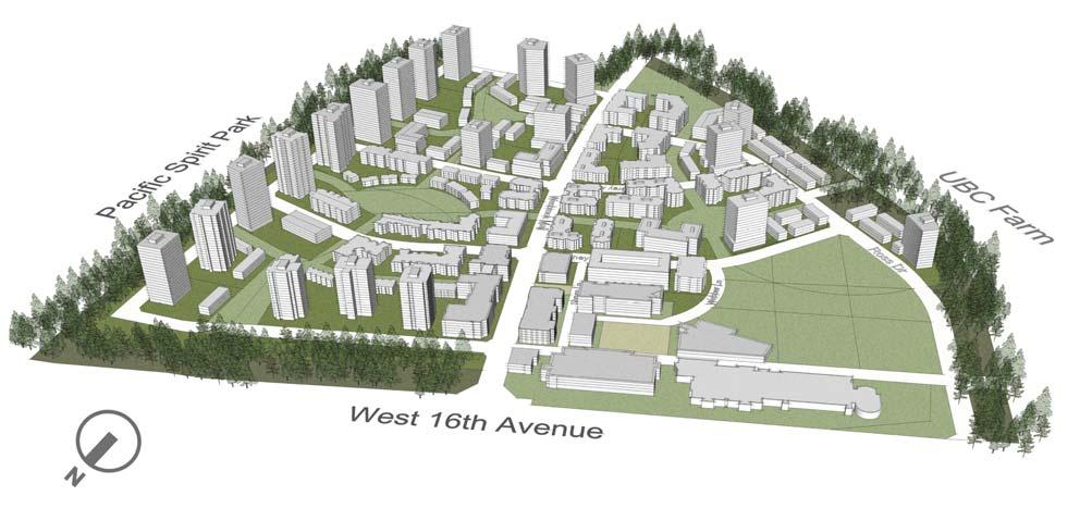
62 Illustrative Plan P-11

63 Rendering of the General Character of the Green Streets ID-1

64 Rendering of the General Character of the Village Centre ID-2

65 Neighbourhood Collector Roads ID-3

66 Local Streets ID-4


67 UNOS OPTION B UNOS OPTION A Character of U.N.O.S. ID-5


68 Sustainable Stormwater Strategy Methods ID-6
ELMVALE ACRES SHOPPING CENTRE MASTER PLAN
 ELMVALE ACRES SHOPPING CENTRE MASTER PLAN Contents 1.0 INTRODUCTION... 2 2.0 LOCATION... 2 3.0 EXISTING CONTEXT... 2 4.0 VISION & GUIDING PRINCIPLES... 2 5.0 LAND USE AND BUILT FORM... 4 5.1 St. Laurent
FORMER CANADIAN FORCES BASE (CFB) ROCKCLIFFE SECONDARY PLAN. Official Plan Amendment XX to the Official Plan for the City of Ottawa
 ROCKCLIFFE SECONDARY PLAN. Official Plan Amendment XX to the Official Plan for the City of Ottawa") FORMER CANADIAN FORCES BASE (CFB) ROCKCLIFFE SECONDARY PLAN Official Plan Amendment XX to the Official Plan for the City of Ottawa 1 INDEX THE STATEMENT OF COMPONENTS PART A THE PREAMBLE PAGE Purpose...
FORMER CANADIAN FORCES BASE (CFB) ROCKCLIFFE SECONDARY PLAN Official Plan Amendment XX to the Official Plan for the City of Ottawa 1 INDEX THE STATEMENT OF COMPONENTS PART A THE PREAMBLE PAGE Purpose...
2.0 Regional Context Statement
 2.0 Regional Context Statement REGIONAL CONTEXT STATEMENT Part 10 of the Municipalities Enabling and Validating Act (No.3) (MEVA), requires UBC to include a Regional Context Statement in a Land Use Plan.
Community Design Guidelines. Port Wallace DRAFT
 Community Design Guidelines Port Wallace DRAFT Energy 1 2 3 Nature Movement Connections Built Form DRAFT Layout Energy 1 Nature Community Design Guidelines GREAT COMMUNITIES PROTECT, CELEBRATE, AND CONSERVE
Complete Neighbourhood Guidelines Review Tool
 Complete Neighbourhood Guidelines Review Tool Prepared By: City of Regina Planning Department October 2014 Page 1 of 14 Community Development Review Checklist for Secondary Plans and Concept Plans The
PORT WHITBY COMMUNITY
 PORT WHITBY COMMUNITY SECONDARY PLAN UPDATE COMMUNITY IMPROVEMENT PLAN URBAN DESIGN GUIDELINES September 2015 DRAFT PROPOSED AMENDMENT NUMBER # to the Whitby Official Plan PURPOSE: The intent of this Amendment
Figure 3-1: Public Realm Plan
 3 Public Realm Figure 3-1: Public Realm Plan 3.1 Public Realm Concept The public realm concept for the Little Mountain site integrates a clear and accessible movement network with public spaces for social
East Bayshore Road Neighbourhood
 East Bayshore Road Neighbourhood Northridge Property Management Urban Design Brief 3195 East Bayshore Road City of Owen Sound January 2016 East Bayshore Road Neighbourhood Northridge Property Management
The West Vaughan Employment Area Secondary Plan Policies
 Part 2: The West Vaughan Employment Area Secondary Plan Policies 2.1 General Policies It is the policy of Council: 2.1.1. That the West Vaughan Employment Area (the WVEA), identified on Schedule 1, will
URBAN DESIGN BRIEF URBAN DESIGN BRIEF 721 FRANKLIN BLVD, CAMBRIDGE August 2018
 URBAN DESIGN BRIEF URBAN DESIGN BRIEF 721 FRANKLIN BLVD, CAMBRIDGE August 2018 DESIGN BRIEF CONTENTS PART A 1.0 INTRODUCTION 2.0 DESCRIPTION & ANALYSIS OF SITE CONTEXT 3.0 DESIGN CONSTRAINTS AND OPPORTUNITIES
Welcome to the Oakridge Centre Open House
 Welcome to the Oakridge Centre Open House Why is the City hosting this event? This open house is to inform you of a rezoning application submitted to the City of Vancouver to amend the existing CD-1 (Comprehensive
Toronto Complete Streets Guidelines
 Toronto Complete Streets Guidelines 108 110 7.1 Green Infrastructure Design Principles 112 7.2 Context-Sensitive Green Streets 114 7.3 Key Green Street Elements Green infrastructure refers to natural and
Queensborough Eastern Neighbourhood Node. Community Open House
 Queensborough Eastern Community Open House The Vision The Queensborough Eastern will become the heart of eastern Queensborough. Through a sensitive mix of viable commercial and residential areas, the neighbourhood
City of Langford Green Development Checklist
 City of Langford Green Development Checklist The following Green Development Checklist creates a sustainability standard for all comprehensive development within the City of Langford. The commitments made
Westwind Developments Ltd. PIONEER LANDS AREA STRUCTURE PLAN - PROPOSED AMENDMENT
 FEBRUARY 2013 TABLE OF CONTENTS 1.0 BACKGROUND... 1 1.1 Amendment... 1 2.0 LOCATION & CONTEXT... 2 2.1 Land Ownership... 2 3.0 POLICY CONTEXT... 3 3.1 Municipal Development Plan... 3 3.2 Capital Region
Smart Growth Development Checklist
 2004 Smart Growth Development Checklist Smart Growth Development Checklist Corporation of the City of New Westminster Guide and manage growth in a manner which is consistent with the principles of sustainable
Clairtrell Area Context Plan
 Clairtrell Area Context Plan March 2005 Urban Development Services City Planning Contents 1. Introduction... 4 2. Development Structure... 6 2.1 Streets... 7 2.1.1 Sheppard Avenue and Bayview Avenue...
Neighborhood Districts
 NEIGHBORHOOD DISTRICTS SEVEN MAIN DISTRICTS Neighborhood Districts While the Development Plan provides a broad-scale overview of the neighborhood, this section focuses on uses and relationships at the
Uptown Rideau Street Secondary Plan [Amendment #166, January 12, 2016]
![Uptown Rideau Street Secondary Plan [Amendment #166, January 12, 2016]](/thumbs/76/73760497.jpg "Uptown Rideau Street Secondary Plan [Amendment #166, January 12, 2016]") [Amendment #166, January 12, 2016] The policies of this Secondary Plan are in effect, save and except for the property at 560 Rideau Street, for which there remains a site specific appeal to this Secondary
[Amendment #166, January 12, 2016] The policies of this Secondary Plan are in effect, save and except for the property at 560 Rideau Street, for which there remains a site specific appeal to this Secondary
include playgrounds, sports fields, community gardens and picnic areas.
 DEVELOPMENT PLAN OPEN SPACE SYSTEM OPEN SPACE SYSTEM The neighborhood provides for a range of open space types. The Village Square is an important open space in the neighborhood. It serves as a gathering
URBAN DESIGN BRIEF 305, 309, & 315 SOUTHDALE ROAD WEST LONDON ONTARIO
 URBAN DESIGN BRIEF 305, 309, & 315 SOUTHDALE ROAD WEST LONDON ONTARIO CARVEST PROPERTIES LTD. December 2013 Section 1 - Land Use Planning Context 1.1 Subject Lands The subject lands are located immediately
1. Parks & Recreation Neighborhood Parks Community Parks Special Use Sites 2. Open Space 3. Trails
 Appendix A: Park Classifications The intent of parks and recreation classifications is to aid in making acquisition and design decisions for park sites, facilities and the organization of recreation space
Urban Design Brief December 23, 2015 Southside Construction Group Official Plan & Zoning By-Law Amendment
 Urban Design Brief Proposed Official Plan & Zoning By-Law Amendment 3244, 3263 and 3274 Wonderland Road South Southside Group December 23, 2015 TABLE OF CONTENTS Page No. INTRODUCTION... 1 SECTION 1 LAND
Land Use Plan. The University of British Columbia Point Grey Campus. Amended to June 2, Pacific Spirit Regional Park
 Land Use Plan The University of British Columbia Point Grey Campus Amended to June 2, 2015 Chancellor Boulevard University Endowment Lands (UEL) Osoyoos Crescent Pacific Spirit Regional Park NW Marine
The Vision. Photo provided by The Minervini Group. 46 Vision, Objectives & Strategies
 Vision, Objectives & Strategies The is the public framework and guide for future development of the Grand Traverse Commons. The establishes public polices for infrastructure, the preservation of natural
COMPLETE GREEN STREET CHECKLIST
 COMPLETE GREEN STREET CHECKLIST This document was developed to dissect the structure of an urban street and explore opportunities to make our streets more complete while also integrating green street strategies.
URBAN DESIGN BRIEF. 2136&2148 Trafalgar Road. Town of Oakville
 URBAN DESIGN BRIEF 2136&2148 Trafalgar Road Town of Oakville Prepared By: METROPOLITAN CONSULTING INC For 2500674 Ontario Inc November 2016 TABLE OF CONTENTS Page No. 1.0 Introduction/Description of Subject
1 Welcome! UBC Okanagan Master Plan Update - Open House
 1 Welcome! UBC Okanagan Master Plan Update - Open House UBC is updating the Master Plan for the Okanagan Campus. The purpose of today s Open House is to: Present the draft 2015 Master Plan Answer any questions
and services The protection and conservation of environmentally significant and sensitive natural heritage features and functions.
 6. Land Use 6.0 Preamble A healthy and livable city is one in which people can enjoy a vibrant economy and a sustainable healthy environment in safe, caring and diverse neighbourhoods. In order to ensure
QUEEN-RIVER SECONDARY PLAN
 34 QUEEN-RIVER SECONDARY PLAN 34. QUEEN RIVER SECONDARY PLAN 1. INTRODUCTION The Queen-River area is approximately 6.4 hectares and is located at the eastern edge of the Downtown as shown on Map 34-1.
Silverdale Regional Center
 Silverdale Regional Center Vision for Silverdale Regional Center The Silverdale Regional Center Plan (Plan) will guide the evolution of the Silverdale Regional Center from a collection of strip malls and
Cambie Corridor Planning Program Phase Two Draft Plan. Standing Committee on City Services and Budgets May 5, 2011
 Cambie Corridor Planning Program Phase Two Draft Plan Standing Committee on City Services and Budgets May 5, 2011 Cambie Corridor Program Terms of Reference approved July 2009 Land Use Transportation Energy
CONTENTS 6.1 URBAN DESIGN
 6-2 Urban Design and Sustainable Development 6.0 URBAN DESIGN AND SUSTAINABLE DEVELOPMENT CONTENTS 6.1 URBAN DESIGN 6.1.1 General Policies 6.1.2 The Public Realm 6.1.3 Streets and Blocks 6.1.4 Streetscapes
PUBLIC RIGHT-OF-WAY IN THIS CHAPTER PUBLIC REALM
 PUBLIC RIGHT-OF-WAY This section provides design guidelines for improvements in the public right-of-way. The public right-of-way refers to streets, sidewalks, non-vehicular thoroughfares, parks and greenways
CONTENTS 8.0 LAND USE 8.1 GENERAL LAND USE 8.2 RESIDENTIAL 8.3 MIXED USE 8.4 COMMERCIAL 8.5 EMPLOYMENT LANDS
 8-2 Land Use 8.0 LAND USE CONTENTS 8.1 GENERAL LAND USE 8.1.1 Uses provided for in all Land Use Designations 8.1.2 Uses prohibited in Hazardous Lands, Hazardous Sites and Special Policy Areas 8.1.3 Uses
FRUITVALE TRANSIT VILLAGE (Phase 2) Residential Project
 Residential Project") FRUITVALE TRANSIT VILLAGE (Phase 2) Residential Project DEVELOPER: SIGNATURE PROPERTIES ARCHITECT: HKIT ARCHITECTS April 23, 2010 TABLE OF CONTENTS 3 Vision 4 Description of Site 5 Guiding Concepts 6
FRUITVALE TRANSIT VILLAGE (Phase 2) Residential Project DEVELOPER: SIGNATURE PROPERTIES ARCHITECT: HKIT ARCHITECTS April 23, 2010 TABLE OF CONTENTS 3 Vision 4 Description of Site 5 Guiding Concepts 6
UBC URBAN STUDIO, FALL 2002 PEDESTRIAN ORIENTED
 SECTION B PEDESTRIAN ORIENTED PATTERN: CITY OF VANCOUVER B.1 Vision Overview Regional Framework Energy 50% of all energy used within the Region to be produced by the Region. Energy production methods to
[PLANNING RATIONALE] For Site Plan Control and Lifting of Holding Zone By-Law 101 Champagne Avenue. May 23, 2014
![[PLANNING RATIONALE] For Site Plan Control and Lifting of Holding Zone By-Law 101 Champagne Avenue. May 23, 2014](/thumbs/75/71599615.jpg "[PLANNING RATIONALE] For Site Plan Control and Lifting of Holding Zone By-Law 101 Champagne Avenue. May 23, 2014") [PLANNING RATIONALE] For Site Plan Control and Lifting of Holding Zone By-Law 101 Champagne Avenue May 23, 2014 Contents 1.0 Introduction... 2 2.0 Site Context... 2 2.1 Adjacent Uses... 2 Figure 1: Site
[PLANNING RATIONALE] For Site Plan Control and Lifting of Holding Zone By-Law 101 Champagne Avenue May 23, 2014 Contents 1.0 Introduction... 2 2.0 Site Context... 2 2.1 Adjacent Uses... 2 Figure 1: Site
Welcome. Walk Around. Talk to Us. Write Down Your Comments
 Welcome This is an information meeting introducing the applications for proposed redevelopment of the Yorkdale Shopping Centre site at 3401 Dufferin Street and 1 Yorkdale Road over the next 20+ years,
THE UNIVERSITY OF BRITISH COLUMBIA
 THE UNIVERSITY OF BRITISH COLUMBIA Report to the Board of Governors Agenda Item # 3.3 SUBJECT REGIONAL CONTEXT STATEMENT MEETING DATE June 4, 2013 APPROVED FOR SUBMISSION Forwarded to the Board of Governors
Urban Design Manual PLANNING AROUND RAPID TRANSIT STATIONS (PARTS) Introduction. Station Study Areas
 Introduction. Station Study Areas") 111111 PLANNING AROUND RAPID TRANSIT STATIONS (PARTS) Introduction The ION rapid transit system will link Waterloo, Kitchener and Cambridge through a central transit corridor (CTC). There are a number
111111 PLANNING AROUND RAPID TRANSIT STATIONS (PARTS) Introduction The ION rapid transit system will link Waterloo, Kitchener and Cambridge through a central transit corridor (CTC). There are a number
DEFINED VILLAGE CENTRES & NEIGHBOURHOODS
 DEFINED VILLAGE CENTRES & NEIGHBOURHOODS residents in Nanoose Bay support focusing attractive, planned future development in Red Gap Centre and the Area s neighbourhood centres. In addition, the development
THE CITY OF WINNIPEG BY-LAW NO. 4/2013. A By-law of THE CITY OF WINNIPEG to adopt a Secondary Plan for the Waverley West Southwest Neighbourhood.
 THE CITY OF WINNIPEG BY-LAW NO. 4/2013 A By-law of THE CITY OF WINNIPEG to adopt a Secondary Plan for the Waverley West Southwest Neighbourhood. THE CITY OF WINNIPEG, in Council assembled, enacts as follows:
Chapter 2: OUTLINE PLANNING APPLICATION PROPOSALS. A New Garden Neighbourhood Matford Barton 17
 Chapter 2: OUTLINE PLANNING APPLICATION PROPOSALS A New Garden Neighbourhood Matford Barton 17 2.1. SUMMARY AND STATUS OF THE PROPOSALS 2.1.1. The parameter plans and associated wording in this chapter
Former Rockcliffe Airbase Community Design Plan Guiding Design Vision and Principles December 4, 2013
 APPENDIX 5 - Guiding Design Vision and Principles Former Rockcliffe Airbase Community Design Plan Guiding Design Vision and Principles December 4, 2013 Vision Statement The redevelopment of the former
KANATA CENTRUM 255 KANATA AVENUE OFFICIAL PLAN AMENDMENT ZONING BY-LAW AMENDMENT
 KANATA CENTRUM 255 KANATA AVENUE OFFICIAL PLAN AMENDMENT ZONING BY-LAW AMENDMENT JUNE 2015 PREPARED BY: FOTENN Consultants Inc. 223 Mcleod Street Ottawa, ON K2P OZ8 (613) 730-5709 PREPARED FOR: Kanata
Regional Context Statement
 Regional Context Statement REGIONAL CONTEXT STATEMENT 3. REGIONAL CONTEXT STATEMENT In 1995, the Provincial Government passed into law the Growth Strategies Act. The purpose of this provincial initiative
Regency Developments. Urban Design Brief. Holyrood DC2 Rezoning
 Regency Developments Urban Design Brief Holyrood DC2 Rezoning Stantec Consulting Ltd. 7-31-2017 1. Overview Regency Developments intends to rezone the lands located at 8510 and 8511 93 Avenue, within the
10.0 Open Space and Public Realm
 10.0 Open Space and Public Realm 10.0 Open Space and Public Realm The Public Open Space System is comprised of: outdoor spaces available for public use that are either publicly owned (e.g., parks and
Cit of Kitchener Ur 6 an Design Manual PARTA. Desi n for _--::
 Cit of Kitchener Ur 6 an Design Manual Date PARTA Year ) Desi n for k Nodes Corridors _--:: Section Page 01 of 12 2 INTRODUCTION Purpose & Application Nodes and Corridors have been identified as key intensification
Official Plan Review
 Official Plan Review Summary Report - The Built Environment August 2014 Part 1: Introduction Planning for a healthy, prosperous and sustainable community is an important goal for our municipality. From
Gold Line Bus Rapid Transit Transit Oriented Development (BRTOD) Helmo Station Area Plan
 Helmo Station Area Plan") Appendix F Gold Line Bus Rapid Transit Transit Oriented Development (BRTOD) Helmo Station Area Plan Introduction and Purpose of the Plan The Gold Line Bus Rapid Transit facility is an eleven-mile dedicated
Appendix F Gold Line Bus Rapid Transit Transit Oriented Development (BRTOD) Helmo Station Area Plan Introduction and Purpose of the Plan The Gold Line Bus Rapid Transit facility is an eleven-mile dedicated
MAYFIELD WEST SECONDARY PLAN PHASE 2
 MAYFIELD WEST SECONDARY PLAN PHASE 2 Public Open House #3 February 25, 2010 Draft Preferred Land Use Scenario TOWN OF CALEDON PLANNING & DEVELOPMENT DEPARTMENT Open House Agenda TOWN OF CALEDON 1. Welcome
Town Center (part of the Comprehensive Plan)
") Town Center (part of the Comprehensive Plan) Mercer Island Town Center Looking North (2014) In 1994, a year-long process culminated in a set of design guidelines and code requirements for the Town Center
Town Center (part of the Comprehensive Plan) Mercer Island Town Center Looking North (2014) In 1994, a year-long process culminated in a set of design guidelines and code requirements for the Town Center
North Oakville East Parks Facilities Distribution Plan. November, 2009
 North Oakville East November, 2009 POLICY CONTEXT 1) Purpose a) The purpose of this document is to be a guide for the location, configuration, design and development of the parks system for the North Oakville
KAMPLAN City of Kamloops. Section D. Land Use Policies D-1
 KAMPLAN City of Kamloops Section D Land Use Policies D-1 City of Kamloops KAMPLAN D 1 Land Management and Development This section links to the following Community Values: D-2 develop complete neighbourhoods
Ten Mile Creek Planning Area
 PLANNING AREA POLICIES TEN MILE CREEK Ten Mile Creek Planning Area Location and Context The Ten Mile Creek Planning Area ( Ten Mile Creek area ) is located south of the current Boise AOCI, generally south
Bylaw No. B-03/2011 Adopted by Airdrie City Council February 21, 2012
 COOPER S CROSSING STAGE 4 Neighbourhood Structure Plan City of Airdrie WESTMARK HOLDINGS LTD. Bylaw No. B-03/2011 Adopted by Airdrie City Council February 21, 2012 CONSULTANTS: LAND USE PLANNING: Southwell
Landscape and Streetscape Design 2.5
 Landscape and Streetscape Design 2.5 2.5.1 Goals 2.5.2 Planting 2.5.3 Sidewalks and Pavement 2.5.4 Furnishings 2.5.5 Walls 2.5.6 Lighting 2.5.7 Stormwater 2.5.8 Street Cross Sections 2.5 LANDSCAPE AND
UTSC SECONDARY PLAN COMMUNITY OPEN HOUSE
 WELCOME TO THE UTSC SECONDARY PLAN COMMUNITY OPEN HOUSE 1 Welcome to the first Community Open House for the UTSC Secondary Plan. Hosted by the University of Toronto Scarborough (UTSC), the following panels
ARTICLE 6: Special and Planned Development Districts
 ARTICLE 6: Special and Planned Development Districts 6-10 Traditional Neighborhood Development (TND) District 6-10.10 Purpose and Intent The Traditional Neighborhood Development (TND) District provides
Bel-Air Lexus Automobile Service Station
 Bel-Air Lexus Automobile Service Station Design Brief 443-447 McArthur Avenue Ottawa April 30, 2015 14-1299-MCA Site Details Application: Site Plan Control Legal Description and Municipal Addresses: 443
Chapter 1. Community Context. Vision Statement Population and Housing Trends Legislative Context Regional Context Statement
 Chapter 1 Community Context Vision Statement Population and Housing Trends Legislative Context Regional Context Statement 1.1 VISION STATEMENT CORPORATE MISSION STATEMENT To promote a safe and livable
Red Fox Commercial Outline Plan
 Red Fox Commercial Outline Plan City of Cold Lake, Alberta Prepared by Durrance Projects Ltd and Ross W. Sharp & Associates Ltd October 2014 Rupert 1 Table of Contents 1. PURPOSE...3 1.1. Location...4
3. VISION AND GOALS. Vision Statement. Goals, Objectives and Policies
 Vision Statement Queen Creek s interconnected network of parks, trails, open spaces and recreation opportunities provide safe and diverse activities and programs that sustain its unique, small town, equestrian
YONGE STEELES CORRIDOR SECONDARY PLAN. Young + Wright / IBI Group Architects Dillon Consulting Ltd. GHK International (Canada) Ltd.
 Ltd.") PART A: PREAMBLE 1.0 PURPOSE The purpose of this Secondary Plan is to provide a development framework for intensification of the Yonge/ Steeles corridor including the north side of Steeles Avenue West
PART A: PREAMBLE 1.0 PURPOSE The purpose of this Secondary Plan is to provide a development framework for intensification of the Yonge/ Steeles corridor including the north side of Steeles Avenue West
Table 8-4: Road Classification Local Roads, second table, of Chapter 8 Create a Multi-Modal City, be amended by adding the following:
 1 Port Street East Official Plan Amendment APPENDIX 3 Amendments to Mississauga Official Plan Table 8-4: Road Classification Local Roads, second table, of Chapter 8 Create a Multi-Modal City, be amended
Transportation. Strategies for Action
 Transportation A major priority for the Overlake Neighborhood is to develop a multimodal transportation system. To achieve this system, a balance has to be found among travel, circulation and access needs;
FROM: General Manager, Planning and Development FILE: (North Grandview Heights)
") Corporate NO: C009 Report COUNCIL DATE: May 18/05 COUNCIL-IN-COMMITTEE TO: Mayor & Council DATE: May 12, 2005 FROM: General Manager, Planning and Development FILE: 6520-20 (North Grandview Heights) SUBJECT:
Corporate NO: C009 Report COUNCIL DATE: May 18/05 COUNCIL-IN-COMMITTEE TO: Mayor & Council DATE: May 12, 2005 FROM: General Manager, Planning and Development FILE: 6520-20 (North Grandview Heights) SUBJECT:
178 Carruthers Properties Inc.
 178 Carruthers Properties Inc. Planning Rationale for 178 Carruthers Avenue Site Plan Control Application June 2014 Table of Contents 1.0 Introduction 2.0 Overview of Subject Property 3.0 Current Zoning
Create a connected ecological network. Connect districts with transit. Let the centre define the community
 District A - D Southeast False Creek A 1 A 2 A 3 A 4 Create a connected ecological network Connect districts with transit Let the centre define the community Provide a variety of affordable housing types
Southwest Fleetwood Enclave
 Southwest Fleetwood Enclave Development Concept Plan Southwest Fleetwood Enclave 1 st Land Owners Meeting April 30 th, 2012 Presentation Overview Why the Plan? ; Overview & Purpose of Study; Constraints
CHAPTER 5: GUIDING PRINCIPLES
 CHAPTER 5: GUIDING PRINCIPLES The following 10 principles were developed based on public consultation, planning policy and the background analysis conducted during Phase 1. The Guiding Principles significantly
Simon Fraser University Official Community Plan
 Simon Fraser University Official Community Plan 1.0 Introduction Adopted 1996 September 9, Amended April 15, 2002 1.1 The Role of the S.F.U. Official Community Plan 1.1.1 The Simon Fraser University Official
CHAPTER 7: VISION AND ACTION STATEMENTS. Noble 2025 Vision Statement
 CHAPTER 7: VISION AND ACTION STATEMENTS This chapter presents the vision, policy and action statements that transform the comprehensive planning study, an analysis of Noble s past, future trends and community
implementation r expression in landscape
 6 ubc okanagan implementation campus plan r expression in landscape 68 6 implementation campus plan sections The Campus Plan supports the academic mission, values and commitments of the University by providing
WELCOME and introduction
 1 WELCOME and introduction Mobility Hub Locations within Burlington STUDY OVERVIEW STUDY OBJECTIVES The City of Burlington is developing four Area Specific Plans, one for each of Burlington s Mobility
Mark-up of the effect of the proposed Bronte Village Growth Area OPA No.18 on the text of section 24, Bronte Village, of the Livable Oakville Plan
 Mark-up of the effect of the proposed Bronte Village Growth Area OPA No.18 on the text of section 24, Bronte Village, of the Livable Oakville Plan Notes: This document is provided for information purposes
4.1.3 LAND USE CATEGORIES
 4.1.3 LAND USE CATEGORIES a. City Center District The City Center District incorporates the existing character and mix of uses in downtown Belmont to encourage redevelopment and new development in keeping
Urban Design Brief Fanshawe Park Road. Competition Toyota
 Urban Design Brief 1300 Fanshawe Park Road Competition Toyota May 2, 2014 TABLE OF CONTENTS Page No. INTRODUCTION... 1 SECTION 1 LAND USE PLANNING CONTEXT... 1 1.1 The Subject Lands... 1 1.2 The Proposal...
New-Cast Mixed-use Development Proposal King Street West, Newcastle, Ontario
 URBAN DESIGN BRIEF New-Cast Mixed-use Development Proposal King Street West, Newcastle, Ontario TABLE OF CONTENTS: 1.0 Executive Summary 2.0 Creating Vibrant and Sustainable Urban Places: Excerpts from
Hockessin Community Redevelopment Plan
 Hockessin Community Redevelopment Plan 3.1 Introduction The Community Redevelopment Plan for the Village of Hockessin is the result of the people s vision for a distinct village center that serves as the
Kelowna Sustainability Checklist
 Kelowna Sustainability Checklist The City of Kelowna endeavours to Sustain the Environment. Encourage development and land use changes that will not compromise the ability of future generations to meet
SDOT DPD. SDOT Director s Rule DPD Director s Rule DCLU DR SED DR of 7 CITY OF SEATTLE
 SDOT SDOT Director s Rule 2-07 DPD Applicant: CITY OF SEATTLE Page 1 of 7 Supersedes: DCLU DR 11-93 SED DR 93-4 Seattle Department of Transportation (SDOT) Department of Planning and Development (DPD)
5.1 Site Plan Guidelines
 5. Community Core Guidelines Development of the Community Core will take place by plan of subdivision and site plan approval. It will occur in a phased manner that will reflect the timing of residential
A Growing Community Rural Settlement Areas
 Town of Huntsville Official Plan Review - POLICY BACKGROUND PAPER A Growing Community Rural Settlement Areas BACKGROUND: In addition to the fully municipally-serviced Urban Settlement Area and the Hidden
Planning, Property and Development Department Report. To the Riel Community Committee
 Planning, Property and Development Department Report To the Riel Community Committee Date: October 30, 2006 File: SP 5/2006 Subject: Waverley West Northeast Neighbourhood Area Structure Plan Location:
4.11 Town Centre Secondary Plan (Former City of Cumberland)
") 4.11 Town Centre Secondary Plan (Former City of Cumberland) 4.11.1 Town Centre Objectives 4.11.1.1 Introduction The reason for the preparation of this Secondary Plan for the Town Centre is as follows:
4.11 Town Centre Secondary Plan (Former City of Cumberland) 4.11.1 Town Centre Objectives 4.11.1.1 Introduction The reason for the preparation of this Secondary Plan for the Town Centre is as follows:
CITY OF LANGLEY OFFICIAL COMMUNITY PLAN BYLAW, 2005, NO APPENDIX II - REGIONAL CONTEXT MAP
 CITY OF LANGLEY OFFICIAL COMMUNITY PLAN BYLAW, 2005, NO. 2600 APPENDIX II - REGIONAL CONTEXT MAP ± Legend Agricultural Mixed Employment Industrial Conservation & Recreation Regional City Centre Urban Containment
REPORT TO THE BOARD OF GOVERNORS
 Agenda Item #6.6 REPORT TO THE BOARD OF GOVERNORS SUBJECT AMENDMENT REGIONAL CONTEXT STATEMENT LAND USE PLAN (VANCOUVER) MEETING DATE November 26, 2013 Forwarded to the Board of Governors on the Recommendation
Urban Design Manual 2.0 DRIVE-THROUGH FACILITIES. Background. Urban Design Challenges
 222221 2.0 DRIVE-THROUGH FACILITIES Background In recent years, drive-through facilities have grown significantly in popularity with drive-through restaurants, in particular, being established on numerous
appendix and street interface guidelines
 appendix five: building and street interface guidelines appendix 5 building and street interface guidelines BOULEVARDS Boulevards are generally characterized by higher levels of traffic movement at higher
section 3: Vision, Values and Goals
 Vision, Values and Goals 3 2041 Vision: Victoria is an urban sustainability leader inspiring innovation, pride and progress towards greater ecological integrity, livability, economic vitality, and community
COLVER ROAD INDUSTRIAL CONCEPT PLAN
 COLVER ROAD INDUSTRIAL CONCEPT PLAN A CONCEPTUAL LAND USE AND TRANSPORTATION PLAN FOR TA-4 AN URBAN RESERVE AREA OF THE CITY TALENT City of Talent Adopted by City Council Resolution No., June, 2015 PART
*** DRAFT 2 FOR PUBLIC REVIEW ***
 6.7 The area is generally bounded by the Red Hill Valley Parkway to the west, Lake Avenue to the east, the Queen Elizabeth Way (QEW) to the north, and by the properties just south of Queenston Road to
DRAFT Northeast Quadrant of Kipling Avenue and Highway 7 DRAFT AUGUST 29, Goals Land Use. The goals of this Plan are to:
 AUGUST 29, 2017 12.15 Northeast Quadrant of Kipling Avenue and Highway 7 12.15.1 Goals 12.15.2 Land Use The goals of this Plan are to: 12.15.2.1 General Provisions: a) Ensure the development of a compact
The transportation system in a community is an
 7 TRANSPORTATION The transportation system in a community is an important factor contributing to the quality of life of the residents. Without a sound transportation system to bring both goods and patrons
BROOKHILL NEIGHBORHOOD MODEL ZONING MAP AMENDMENT PREFACE TO APPLICATION
 BROOKHILL NEIGHBORHOOD MODEL ZONING MAP AMENDMENT PREFACE TO APPLICATION June 15, 2015 Revised: August 1, 2016 I. VISION Brookhill is a proposed community based upon the principles of Albemarle County
2.0 A FRAMEWORK FOR SUSTAINABLE GROWTH CONTENTS
 2-2 A Framework for Sustainable Growth 2.0 A FRAMEWORK FOR SUSTAINABLE GROWTH CONTENTS 2.1 MANAGING SUSTAINABLE GROWTH THE VISION TO 2031 2.2 GOALS AND OBJECTIVES 2.2.1 Protecting the Natural Environment
COMMUNITY HEART HEATHER STREET LANDS
 COMMUNITY HEART PLAZA AT HARVARD, CAMBRIDGE VISUALIZATION OF THE COMMUNITY HEART FROM 33RD AVENUE The concept includes an active mix of uses around open space to support all-day vibrancy. Anchored by the