CITY OF CALABASAS FINAL ENGINEER S REPORT. LANDSCAPE LIGHTING ACT DISTRICTS NOS. 22, 24, 27 & 32 (1972 Act Districts) FISCAL YEAR
|
|
|
- Amanda Norris
- 5 years ago
- Views:
Transcription
 Landscape Lighting Act District No. 24 (LOST HILLS ROAD & THE SARATOGAS) Landscape Lighting Act District No. 27 (LAS VIRGENES ROAD) Landscape Lighting Act District No.")
1 CITY OF CALABASAS FINAL ENGINEER S REPORT LANDSCAPE LIGHTING ACT DISTRICTS NOS. 22, 24, 27 & 32 (1972 Act Districts) FISCAL YEAR Landscape Lighting Act District No. 22 (CALABASAS PARK AREA) Landscape Lighting Act District No. 24 (LOST HILLS ROAD & THE SARATOGAS) Landscape Lighting Act District No. 27 (LAS VIRGENES ROAD) Landscape Lighting Act District No. 32 (AGOURA ROAD/LOST HILLS ROAD COMMERCIAL DISTRICT) June 22, 2016
2 CITY OF CALABASAS LANDSCAPE LIGHTING ACT DISTRICT NOS. 22, 24, 27 & 32 (1972 Act Districts) FINAL ENGINEER S REPORT FISCAL YEAR TABLE OF CONTENTS BACKGROUND AND INTRODUCTION 1 PLANS AND SPECIFICATIONS 3 IMPROVEMENTS 4 ESTIMATE OF COST 5 METHOD OF APPORTIONMENT OF ASSESSMENTS 6 Page LANDSCAPE LIGHTING ACT DISTRICT NO LANDSCAPE LIGHTING ACT DISTRICT NO LANDSCAPE LIGHTING ACT DISTRICT NO LANDSCAPE LIGHTING ACT DISTRICT NO ASSESSMENT ROLL 21 ANNEXATIONS AND DETACHMENTS 22 LIST OF EXHIBITS EXHIBIT A- DISTRICT NO. 22 Landscape Maintenance Costs and Assessments by Zone EXHIBIT B- DISTRICT NO. 24 Landscape Maintenance Costs and Assessments by Zone EXHIBIT C- DISTRICT NO. 27 Landscape Maintenance Costs and Assessments by Zone EXHIBIT D- DISTRICT NO. 32 Landscape Maintenance Costs and Assessments by Zone EXHIBIT E - DISTRICT NO. 22 Assessment Rates History EXHIBIT F - BOUNDARY DIAGRAMS Page i
3 CITY OF CALABASAS LANDSCAPING LIGHTING ACT DISTRICT NOS. 22, 24, 27 & 32 (1972 Act Districts) FINAL ENGINEER S REPORT FISCAL YEAR BACKGROUND AND INTRODUCTION BACKGROUND Prior to the incorporation of the City of Calabasas, the County of Los Angeles formed the following Districts pursuant to the Landscaping and Lighting Act of 1972 (Streets & Highways Code Section et seq.): Landscape Lighting Act District No. 22 (CALABASAS PARK AREA) (Formed in 1979) Landscape Lighting Act District No. 24 (LOST HILLS ROAD AND THE SARATOGAS) (Formed in 1984) Landscape Lighting Act District No. 27 (LAS VIRGENES ROAD) (Formed in 1984) Landscape Lighting Act District No. 32 (AGOURA ROAD/LOST HILLS ROAD COMMERCIAL DISTRICT) (Formed in 1989) In July 1995, the County of Los Angeles transferred all four Districts to the City of Calabasas. These 1972 Act Districts fund landscape maintenance services and are funded by annual benefit assessments levied against each parcel in each District. The word lighting was apparently included in their names as a reference to the Landscaping and Lighting Act of In Fiscal Year , assessment ballot proceedings were conducted pursuant to Proposition 218 (Articles XIII C and XIII D of the California Constitution) for each of the four Districts. There was not a majority protest against any of the assessments, and the assessment methodology was approved by the City Council. The approved methodology reserved to the City Council the right each year to implement an inflation adjustment in these Districts. Implementation of the annual inflation adjustment, which is based on the Consumer Price Index (CPI), does not constitute an assessment increase for purposes of Proposition 218, because landowners in the Fiscal Year assessment ballot and subsequent ballotings authorized these adjustments. INTRODUCTION This report was prepared in response to the City Council action ordering a report for the levy of assessments for the fiscal year commencing July 1, 2015 and ending June 30, This report is prepared in compliance with the requirements of Proposition 218, and the Landscaping and Lighting Act of This report presents the engineering analysis for the annual administration of the four Districts. Through the levy and collection of benefit assessments, the four Districts fund maintenance and operation of landscape improvements. For Fiscal Year , Landscape Lighting Act District Nos. 22, 24, 27 and 32 assessments will be levied based on the previously approved methodology, at the same rate as was in effect in Fiscal Year , plus a 0.91% CPI inflation adjustment as recommended by the City of Calabasas Chief Financial Officer. As the assessments are levied on the basis of benefit, they are not considered a tax, and, therefore, are not governed by Article XIII A of the Constitution of the State of California. The assessments are governed by Articles XIII D of the Constitution. 1 P age
4 For the Fiscal Year , the City of Calabasas, at the request of Mont Calabasas member homeowner association (HOA) Board of Directors, proposes annexing Mont Calabasas HOA Zone into Landscaping Lighting District No. 27 (LLAD27). In compliance with Proposition 218, the proposed annexation into the District and assessment will be submitted to the property owners via mailed ballots. The ballots will be tabulated June 13, 2016, and reported at the June 22, 2016 Council Meeting to determine if there is a majority protest against the proposed annexation. Landscaping Improvements These Districts provide for the installation, operation, maintenance, and servicing of landscape improvements. The Landscaping and Lighting Act of 1972 allows the Districts to provide funding for the installation, maintenance, operation, servicing and administration of the following landscape improvements: The installation or planting of landscape; The installation or construction of statuary, fountains, or other ornamental structures; The installation or construction of public lighting facilities (by City policy limited to lighting of parkland and major landscaping); The installation or construction of facilities which are appurtenant to any of the foregoing or which are necessary or convenient for the maintenance and servicing thereof, including, but not limited to grading, clearing, removal of debris, the installation or construction of curbs, gutters, sidewalks, walls, paving, or water, irrigation, drainage or electrical facilities; The installation of park or recreational improvements; The maintenance or servicing, or both, of any of the foregoing; The acquisition of land for park, recreational, or open space purposes; The acquisition of any existing improvement otherwise authorized pursuant to section of the Streets and Highways Code. Maintenance means the furnishing of services and materials for the ordinary and usual maintenance, operation, and servicing of any improvement, including: Repair, removal or replacement of all or any part of any improvement; Providing for the life, growth, health, and beauty of landscape, including cultivation, irrigation, trimming, spraying, fertilizing, or treating for plant disease or injury; The removal of trimmings, rubbish, debris, and other solid waste from common area landscape or hardscape, Cleaning and sandblasting to remove or cover graffiti; Servicing means the furnishing of: Water for irrigation of any landscaping, operation of any fountains or maintenance of any other improvements; Electrical current or energy, gas, or other illuminating agent for any public lighting facilities or for lighting or operation of any other improvements. Note that the four Districts do not necessarily provide every service authorized under the 1972 Act. For example, while these Districts provide electrical current to power irrigation systems, fountains, landscape lighting, Calabasas Lake aeration systems, and Association Park lake sidewalk lighting, they do not fund LLAD residential or commercial district street lighting. 2 P age
5 CITY OF CALABASAS LANDSCAPE LIGHTING ACT DISTRICT NOS. 22, 24, 27 & 32 (1972 ACT DISTRICTS) FINAL ENGINEER S REPORT FISCAL YEAR PLANS AND SPECIFICATIONS Several items related to the Districts are on file and available for review at the City of Calabasas Public Works Department, Landscape Maintenance Division office. The items listed below are incorporated into this Engineer's Report by reference. The lines and dimensions of each lot or parcel within the Assessment Districts are those lines and dimensions shown on the maps of the Assessor of the County of Los Angeles for the year when this Report is prepared. The Assessor s maps and records are incorporated by reference herein and made part of this Report. Plans and specifications showing each District s exterior boundaries; and indicating the general nature, location and extent of improvements. For Landscape Lighting Act District No. 22, each member HOA has an individual maintenance contract. The member HOAs have been designated as Zones ; each Zone has been given a number. The City has on file for each Zone a maintenance contract listing the work contracted and a diagram(s) detailing maintenance service work areas. 3 P age
6 CITY OF CALABASAS LANDSCAPE LIGHTING ACT DISTRICT NOS. 22, 24, 27 & 32 (1972 ACT DISTRICTS) FINAL ENGINEER S REPORT FISCAL YEAR IMPROVEMENTS The landscape lighting act Districts provide funds for the operation, maintenance and services for the landscape improvements in each District. District Nos. 22, 24, 27, and 32 typically may provide the following landscape maintenance services for the improvements listed in each District below: Installation, maintenance, repair, removal or replacement of landscape improvements in a manner that provides for the life, growth, health, and beauty of the landscape; Tree installation, tree trimming or tree removal; Landscape rodent and pest control; Fertilization or treating for plant disease or injury; Removal of trimmings, rubbish, debris, and other solid waste from common area landscape or hardscape; Graffiti removal; Maintenance, repair, and replacement as necessary of all irrigation systems; Energy costs of the irrigation control system; Furnishing of irrigation water; Exterior inspection and cleaning only of drainage structures; not interior inspection, repair or replacement; Annual weed abatement/brush clearance for fuel reduction/fire safety. The landscape improvements maintained by each District are generally described as follows: Landscape Lighting Act District No. 22 LLAD 22 provides for the maintenance of landscape of the common areas and open space areas located within member homeowner associations (HOA) referred to as Zones. The HOA common areas are either owned in common or privately owned, with easements granted to the District for landscape maintenance purposes. The maintenance of landscape also includes greenbelt and slope areas as well as annual weed abatement/brush clearance for fuel reduction/fire safety. Landscape Lighting Act District No. 24 LLAD 24 provides maintenance of landscape within street right-of-way and open space areas. The open space areas include slopes and creek banks. Maintenance of landscape on streets within rightof-way includes parkways, center medians, adjacent turf areas, trees, and annual weed abatement/brush clearance for fuel reduction/fire safety. Landscape Lighting Act District No. 27 LLAD 27 provides maintenance of landscape within street right-of-way. Maintenance of landscape on streets within right-of-way includes parkways, center medians, and street trees. Landscape Lighting Act District No. 32 LLAD 32 provides maintenance of landscape within street right-of-way. Maintenance of landscape on streets within right-of-way includes center medians and street trees. 4 P age
7 CITY OF CALABASAS LANDSCAPE LIGHTING ACT DISTRICT NOS. 22, 24, 27 & 32 (1972 ACT DISTRICTS) FINAL ENGINEER S REPORT FISCAL YEAR ESTIMATE OF COST The estimated budget for Fiscal Year for each District is shown in the table below. The beginning fund balance estimated for July 1, 2016, is projected from budget year. These fund balances are used to finance all work from July 1, 2016 until June 30, The first deposit from the County Assessor's Office to the District s accounts is December The projected carryover from FY will be the beginning fund balance for Fiscal Year and so forth. CITY OF CALABASAS LANDSCAPE LIGHTING ACT DISTRICT NOS. 22, 24, 27 & 32 SOURCES AND USES FOR FY LLAD 22 LLAD 24 LLAD 27 LLAD 32 SOURCES BEGINNING BALANCE (Est.) 169, ,300 28,600 6,200 BENEFIT ASSESSMENT * 2,837, ,200 32,600 33,400 OTHER CITY FUNDS 1,000,000 INTEREST 2,500 3, TOTAL SOURCES 4,009, ,500 61,600 39,700 USES CITY ADMINISTRATIVE COSTS (SALARIES, CONSULTANTS, INCIDENTAL COSTS, ETC.) 157,400 10,500 3,100 2,500 UTILITIES (IRRIGATION WATER & ELECTRICAL TO POWER IRRIGATION CONTROLLERS) 839,900 26,600 2,400 4,900 MAINTENANCE CONTRACTS/PEST CONTROL 1,304, ,000 38,700 25,600 TREE MAINTENANCE (INSTALLATION, TRIMMING, 302,200 38,200 14,700 1,000 REMOVALS) FIRE BREAK / BRUSH CLEARANCE 317,100 21, CAPITAL IMPROVEMENTS GENERAL BENEFIT LANDSCAPING IMPROVEMENTS* 1,000, TOTAL USES 3,921, ,300 58,900 34,000 ENDING BALANCE CARRYOVER 87, ,200 2,700 5,700 *Other City Funds funds the maintenance of general benefit landscape improvements. See LLAD No. 22 General Benefit. The City of Calabasas Chief Financial Officer provided the FY Budget Sources and Uses and Consumer Price Index increase 0.91%. The detailed records for the costs, utilities, maintenance contracts and other uses are on file at the City of Calabasas. 5 P age
8 CITY OF CALABASAS LANDSCAPE LIGHTING ACT DISTRICT NOS. 22, 24, 27 & 32 FINAL ENGINEER S REPORT FISCAL YEAR METHOD OF APPORTIONMENT OF ASSESSMENT Proposition 218 requires that a parcel's assessment may not exceed the reasonable cost of the proportional special benefit conferred on that parcel. The Articles provide that only special benefits are assessable. The City must separate the general benefits from the special benefits conferred on a parcel; a special benefit being a particular and distinct benefit over and above general benefits conferred on the public at large, including real property within the district. In Fiscal Year , the four Districts conducted an assessment ballot proceeding pursuant to Proposition 218; the assessment methodology was approved by a majority of District parcel owners and the City Council. The City reserves the right to implement the previously approved inflation adjustment in these Districts. Implementation of the annual inflation adjustment, which is based on the annual Consumer Price Index (CPI), does not constitute an assessment increase for purposes of Proposition 218, because parcel owners in the Fiscal Year assessment ballot and subsequent ballotings authorized these adjustments. Assessments for the Districts are subject to an increase each year equal to the 12-month average percent change in the annual Consumer Price Index, All Urban Consumers, for the Los Angeles- Riverside-Orange County Area ("CPI"), from January 1st through December 31st of the fiscal year prior to the subject fiscal year. Future annual budgets within this limit may be approved by the City Council without additional property owner ratification. A CPI increase may be exceeded only by a majority parcel owner approval. For Fiscal Year , Landscape Lighting Act District Nos. 22, 24, 27, and 32 assessments will be increased by 0.91% annual CPI inflation adjustment per the City of Calabasas Chief Financial Officer. Each District will be discussed in terms of background, special benefit, general benefit, and assessment formula. Certain terms used throughout the Method of Assessment are defined below. DEFINITIONS Special Benefit: Articles XIII C and XIII D of the California Constitution define special benefit as "a particular and distinct benefit over and above the general benefits conferred on real property located in the District or to the public at large. General enhancement of property value does not constitute 'special benefit.'" The following Method of Apportionment of Assessment for each District analyzes the special benefit each parcel receives from the improvements funded in each District. The cost of landscape maintenance is distributed to parcels in each District based on the special benefit each parcel receives by an assessment formula. Within the Districts, zones of benefit may be designated based on spreading the cost of the improvements associated with each Zone over the parcels within that Zone. Each assessed parcel within each District receives a particular and distinct Special Benefit from the improvements. The operation and maintenance of the landscape improvements provides a Special Benefit to the parcels within each District even though there may not be landscaping immediately adjacent to a particular parcel. Special Benefits associated with landscaped improvements are: 6 P age
9 The proper maintenance of landscape along streets provides noise abatement and visual barriers to reduce the negative impact of the streets upon nearby parcels within the District. Landscape improvements provide environmental enhancement to nearby parcels through erosion control, dust and debris control, and weed abatement for fire safety. The aesthetic desirability of parcels within the District is specifically enhanced by the presence of well-maintained open space, greenbelts, street medians, and frontage landscape. Having properly maintained landscape readily accessible to properties within the District means the owners of the assessed parcels may enjoy the benefits of having such improvements available for use while avoiding the effort and expense of individually installing and maintaining similar improvements. Where the District is providing maintenance along easements on privately held property, it is providing landscape services that otherwise would be direct expenses of the owners of such property. State and City laws generally hold property owners individually responsible for the safe and proper maintenance of their frontages. Zones: Landscape Lighting Act District No. 22 (1972 Act District) Calabasas Park Area has been divided into Zones of benefit by individual communities or neighborhoods that receive distinct Special Benefit. In most cases, Zones are defined by the boundaries of a homeowners association. In a few cases, the Zone is based on master plan boundaries (Old Town Master Plan) or street boundaries. The landscape maintenance activities that provide a Special Benefit are separately identified by the City for each Zone. Based on an assessment formula, the cost of these landscape maintenance activities is then spread to the parcels within that Zone. Assessment Units: The assessment units assigned to each parcel are used in the assessment formula to compute the assessment amount. If the zone has one single land use, then each parcel is assigned one assessment unit. Where more than one land use exists within a zone, traffic generation factors are used as a means to define the benefit a single family residence receives as compared to an apartment or a commercial property. The following traffic generation factors for the City of Calabasas and resulting Assessment Units are incorporated in this Report. Per Parcel Land Use Traffic Generation Factor Assessment Unit Single Family Residential (Houses and Condominiums) 10 trips per day 1.0 (10 trips/10 trips) per parcel Multi-Family Residential (Apartments) 6 trips per day 0.6 (6 trips/10 trips) per unit) Commercial Parcel 40 trips per day 4.0 (40 trips/10 trips) per acre Note: Traffic Generation Factor is based on information provided by the City of Calabasas in Due to minor changes in development in the area since this time, these results continue to be representative of the traffic generated in the assessment district. 7 P age
10 The Method of Assessment for each District is provided in the following sections. LANDSCAPE LIGHTING ACT DISTRICT NO. 22 (1972 ACT DISTRICT) (CALABASAS PARK AREA) METHOD OF APPORTIONMENT OF ASSESSMENTS For Fiscal Year , Landscape Lighting Act District No. 22 (LLAD 22) assessments will be levied based on previously approved methodology and will be levied at the same rate as in Fiscal Year with a 0.91 % annual CPI inflation adjustment. IMPROVEMENTS LLAD 22 provides for the maintenance of landscape of the common areas and open space areas located within member homeowner associations (HOA). The HOA common areas are either owned in common or privately owned, with easements granted to the District for landscape maintenance purposes. The maintenance of landscape also includes greenbelt and slope areas as well as annual weed abatement/brush clearance for fuel reduction/fire safety. LLAD 22 provides funding for the installation, maintenance, operation, and administration of the following landscape improvements: Improvement means one or any combination of the following: The installation or planting of landscape; The installation of trees; The installation or construction of statuary, fountains, or other ornamental structures; The installation or construction, of public lighting facilities (by City policy limited to lighting of parkland and major landscaping); The installation or construction of facilities which are appurtenant to any of the foregoing or which are necessary or convenient for the maintenance and servicing thereof, including, but not limited to grading, clearing, removal of debris, the installation or construction of curbs, gutters, sidewalks, walls, or paving, or water, irrigation, drainage or electrical facilities; The installation of park or recreational improvements; The maintenance or servicing, or both, of any of the foregoing; The acquisition of land for park, recreational, or open space purposes; The acquisition of any existing improvement otherwise authorized pursuant to section of the Streets and Highways Code. Maintenance means the furnishing of services and materials for the ordinary and usual maintenance, operation, and servicing of any improvement, including: Providing for the life, growth, health, and beauty of landscape, including cultivation, irrigation, trimming, spraying, fertilizing, or treating for plant disease or injury; Repair, removal or replacement of all or any part of any improvement; The removal of weeds, trimmings, rubbish, debris, and other solid waste from common area landscape or hardscape; Cleaning and sandblasting to remove or cover graffiti; 8 P age
11 Exterior inspection and cleaning only of drainage structures; not interior inspection, repair or replacement; Annual weed abatement/brush clearance for fuel reduction/fire safety; Landscape rodent and pest control; Trimming or removal of trees. Servicing means the furnishing of: Water for irrigation of any landscape, operation of any fountains or maintenance of any other improvements; Electrical to power irrigation systems, fountains, and landscape lighting. METHODOLOGY The following methodology described pertains to Landscape Lighting Act District No. 22 (1972 Act). The landscape services provided to all properties within the district boundary have been reviewed to identify the General Benefit and Special Benefit conferred to each parcel. GENERAL BENEFIT Articles XIII C and XIII D of the California Constitution require that the benefit to the public at large be identified for any improvements being funded through an assessment district. This so-called "general" benefit may not be assessed to the parcels through an assessment district. The following Method of Apportionment of Assessment for the District analyzes the benefit to the public at large from the landscape improvements provided by the City for the District. In LLAD 22, certain portions of improvements are identified as providing general benefit. The costs associated with these improvements are not included in the LLAD 22 budget assessed to parcels in the District. Instead, these costs are funded through Landscape Maintenance District No. 22 (LMD 22), via an existing ad valorem tax levy. Proposition 218 does not govern the ad valorem levy, and the proceeds of this ad valorem levy may be used toward any landscape improvements providing general benefit within the LMD 22/LLAD 22 boundary. The following landscape improvements provide general benefit and are funded solely by LMD 22, via the existing ad valorem tax levy and are not funded by LLAD 22. Maintenance of landscape on major thoroughfare roadways, including portions of Calabasas Road, Civic Center Way, Park Capri, Park Entrada, Park Granada, median islands on Park Helena and Park Sienna, Park Ora, certain parkway areas on Park Sorrento, Parkway Calabasas, Association Park, Calabasas Lake, and natural areas such as McCoy Creek, and open space areas within the district boundary. The roadways are thoroughfares for the community, providing access to schools, shops, freeways, and recreational facilities, and therefore, confer a General Benefit to the community. The landscape along these streets includes parkway landscape that serves to improve the stabilization of slopes adjacent to these roadway sections within the District. SPECIAL BENEFIT With the exception of the major public thoroughfare roadways located within the boundaries of District LLAD 22 as described above in General Benefit, all of the areas maintained by LLAD 22 are either owned in common or are privately owned and are solely accessible to (or primarily accessible to) owners of the assessed properties, their tenants, and/or guests. These areas have easements granted to LLAD 22 for landscape maintenance purposes. 9 P age
12 The local landscape improvements associated within member homeowner associations, provide special benefits to the properties within those developments, and have no benefit to the public at large, to individuals rather than property, or to properties located outside of the district. The landscape improvements of the common areas located within member homeowner associations are of direct and special benefit to the assessed properties. Consequently, 100% of these costs are allocated to special benefit. In order for the methodology to be in compliance with Articles XIII C and XIII D of the California Constitution, a thorough study of the landscape funded by the District was performed in The District was divided by tracts into member homeowner associations and a commercial district that are called Zones. These Zones receive distinct special benefit. In a few cases, the Zone is based on master plan boundaries (Old Town Master Plan) or street boundaries. Each Zone s specific usage and landscape maintenance activities were identified to determine the level of special benefit each property receives within that Zone. The landscape maintenance activities that provide a Special Benefit have been determined for each Zone. The LLAD 22 Zones are as follows: Bellagio Calabasas Country Estates Calabasas Hills Classic Calabasas Park Calabasas Park Estates Calabasas Rd. Commercial* Clairidge Las Villas Oak Creek Oak Park The Oaks of Calabasas ** Palatino Vista Pointe Westridge * Calabasas Rd. Commercial includes Old Town **The Oaks of Calabasas Zone is comprised of The Oaks of Calabasas and The Estates of The Oaks of Calabasas HOAs. A complete landscape maintenance service level was developed for each Zone to determine the Zone s aggregate LLAD 22 assessment levy and detail the Special Benefit each Zone receives from the District. The aggregate LLAD 22 assessment levy for each Zone includes costs associated with maintaining improvements that specially benefit the given Zone. Many of the costs are for local landscape improvements that can be accessed only by member homeowner association parcel owners, their tenants, or guests. In virtually all cases, the improvements were part of a condition of development and the assessed properties are responsible for the ongoing landscape maintenance. PARCEL CLASSIFICATION These costs are apportioned to each parcel within each Zone based on the Special Benefit associated with the type of land use. The benefit relationship between land uses is based on the assignment of vehicle trip generation factors. Trip rates are used as a measure of benefit because they are a representative land use comparison factor for the type of improvements being funded, namely street landscape, slopes, common areas, parks, and open space. From the traffic generation factors Assessment Units are calculated. The Assessment Unit for each land use is computed based on its traffic generation compared to the traffic generated by a single-family residence. Single Family Residence parcels in the City of Calabasas generate an average of 10 trips per day. A parcel is classified as a Single Family Residential use upon recordation of a subdivision map for houses 10 P age
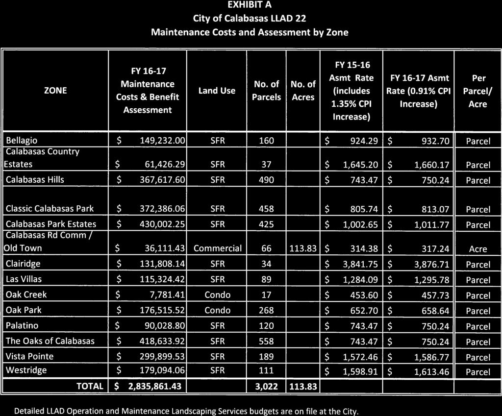
13 or condominiums. The Single Family Residences are assigned the base Assessment Unit of 1 and are used as the basis of comparison for all other land uses in the District. At this time, there are no Multiple Family Residential parcels (apartments) in the District. If at a later date, any parcel in the District comes under this land use, it would be assessed to reflect the available data that indicates Multiple Family Residential. Parcels in the City of Calabasas generate an average of 6 trips per day, or 0.6 Assessment Unit per unit. Therefore, the Assessment Units assigned to a multiple family parcel would be the product of the number of dwelling units on a parcel and 0.6 Assessment Units per unit. For instance, a 20-unit apartment house would be assigned 20 x 0.6 = 12 Assessment Units. Residential Vacant (unsubdivided but buildable) property receives a Special Benefit from the improvements as a result of the increased desirability of a parcel that is located in an area with landscape and park amenities. In addition, vacant parcels specially benefit from the availability of a landscape program and access to the City s landscape manager. Commercial property within the City of Calabasas generates on average 40 trips per day. Therefore, the Assessment Units assigned to a commercial property is 4.0 Assessment Units per acre. At this time, all commercial properties in the District are within the Calabasas Road/ Old Town Commercial Zone, which also encompasses the Old Town Master Plan area. The commercial properties in the Calabasas Road/ Old Town Commercial Zone receive benefit from Calabasas Road maintenance. The cost for these specific improvements will be distributed to the properties within the Zone based on each parcel's land area (acreage). Public Agency parcels within the District that have people working on the premises and have parkway landscape maintained by the District, benefit from the landscape improvements to their parkway maintenance, as do other similar parcels. The only Public Agency parcels subject to the assessment are the Civic Center and the Tennis and Swim Center. For purposes of the assessment, these parcels are considered part of the Calabasas Road Commercial/Old Town Master Plan Zone. Therefore, the Civic Center and the Tennis and Swim center will receive the same per acre charge as the Commercial properties in the Calabasas Road Commercial/Old Town Master Plan Zone. Homeowner's Association and Common Area parcels within the District are not assessed. These parcels include large park parcels, small sliver parcels, and parking lot parcels that cannot be developed. These unbuildable properties do not receive a special benefit from the District s improvements and are not assessed. In many cases, the common area parcels provide the same use and function that the District funded improvements provide. In addition, the property owners paying the Homeowner's Association bill are already paying for the District s funded improvements by their parcel s assessment. The common area property is incidental to the primary residential parcels. Therefore, the assessment will go directly to the source and assess the properties that benefit from the Zone s improvements and maintenance. FORMULA OF ASSESSMENT The District budget requirements for the special benefit improvement costs have been assembled in order to determine the aggregate levy of assessment for Landscape Lighting Act District No. 22 (1972 Act) by Zone. The total aggregate levy for each LLAD 22 Zone is divided by the number of assessment units to determine the assessment amount per unit. The assessment amount per unit is multiplied by the number of assessment units assigned to the parcel to determine each parcel s assessment. See Exhibit A for the Landscape Lighting Act District No. 22 (1972 Act) Assessments by Zone. 11 P age
14 For example, a Zone that only has single-family residence parcels is assigned 1 assessment unit per parcel, and the assessment per parcel is calculated as follows: Zone Total Levy Amount Zone Total Assessment Units (Parcels) = Assessment Amount per Unit (Parcel) 12 P age
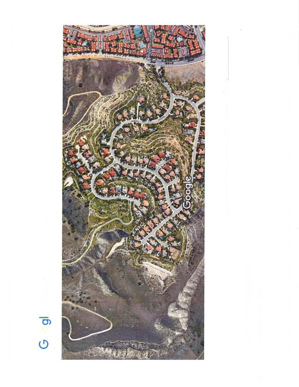
15 LANDSCAPE LIGHTING ACT DISTRICT NO. 24 (1972 ACT DISTRICT) (LOST HILLS) METHOD OF APPORTIONMENT OF ASSESSMENTS For the Fiscal Year , the assessments in Landscape Lighting Act District No. 24 (LLAD 24) will be levied at the same rate as in Fiscal Year plus a 0.91% CPI annual inflation adjustment. IMPROVEMENTS LLAD 24 provides maintenance of landscape within street right-of-way and open space areas. The open space areas include slopes and creek banks. Maintenance of landscape on streets within rightof-way includes parkways, center medians, adjacent turf areas, trees, and annual weed abatement/brush clearance for fuel reduction/fire safety. Roadways with landscape in the public right-of-way includes landscaped center medians, trees, and adjacent turf areas that are conditions of development and are maintained by the District to soften and mitigate the impacts of traffic on the residential tracts within the District. The landscape improvements are located on the residential roadway serving the Malibu Lost Hills community, including Lost Hills Road south of Malibu Hills Road to Las Virgenes Road, Calabasas Hills Road, Meadow Creek Lane, portions of Las Virgenes Road, and designated slope areas along Las Virgenes Creek. LLAD 24 provides funding for the installation, maintenance, operation, and administration of the following landscape improvements: Improvement means one or any combination of the following: The installation or planting of landscape; The installation of trees; The installation or construction of statuary, fountains, or other ornamental structures; The installation or construction, of public lighting facilities (by City policy limited to lighting of parkland and major landscaping); The installation or construction of facilities which are appurtenant to any of the foregoing or which are necessary or convenient for the maintenance and servicing thereof, including, but not limited to grading, clearing, removal of debris, the installation or construction of curbs, gutters, sidewalks, walls, or paving, or water, irrigation, drainage or electrical facilities; The installation of park or recreational improvements; The maintenance or servicing, or both, of any of the foregoing; The acquisition of land for park, recreational, or open space purposes; The acquisition of any existing improvement otherwise authorized pursuant to section of the Streets and Highways Code. Maintenance means the furnishing of services and materials for the ordinary and usual maintenance, operation, and servicing of any improvement, including: Providing for the life, growth, health, and beauty of landscaping, including cultivation, irrigation, trimming, spraying, fertilizing, or treating for plant disease or injury; Repair, removal or replacement of all or any part of any improvement; The removal of weeds, trimmings, rubbish, debris, and other solid waste from landscape or hardscape; Cleaning and sandblasting to remove or cover graffiti; 13 P age
16 Exterior inspection and cleaning only of drainage structures; not interior inspection, repair or replacement; Annual weed abatement/brush clearance for fuel reduction/fire safety; Landscape rodent and pest control; Trimming or removal of trees. Servicing, means the furnishing of: Water for the irrigation of any landscape, the operation of any fountains or the maintenance of any other improvements; Electrical to power irrigation systems, fountains, and landscape lighting. METHODOLOGY The following methodology described pertains to the Landscape Lighting Act District No. 24 (1972 Act) herein referred to in this section as LLAD 24. The landscape services provided to all properties within the district boundary have been reviewed to identify the General Benefit and Special Benefit conferred to each parcel. GENERAL/SPECIAL BENEFIT The local landscape improvements provide special benefits to the properties within those developments, and have no benefit to the public at large, to individuals rather than property, or to properties located outside of the district. The maintenance of landscape improvements within street right-of-way and open space located within the District are of direct and special benefit to the assessed properties. Consequently, 100% of these costs are allocated to special benefit, and the special benefits associated with the landscaped improvements include: The aesthetic desirability of parcels within the District is specifically enhanced by the presence of well-maintained open space, greenbelts, street medians, and frontage landscaping. Public rights-of-way with landscaped center medians, trees, and adjacent turf areas maintained by the District provide noise abatement and visual barrier to mitigate the negative impact of streets upon nearby parcels within the District. The special benefits derived from the maintenance of these landscape improvements provide environmental enhancement to nearby parcels through erosion control, dust and debris control, and weed abatement for safety. Additional special benefits of landscape maintenance are described earlier in this Report. Other residential areas of the City that are not included in an assessment district receive a minimal standard of City-funded landscape maintenance. The standard City landscaping for streets includes minimal median and parkway landscape. The City policy, therefore, is to have homeowner associations or landscaping and lighting districts fund certain landscaping maintenance, enhancements, and servicing. As a result, there is no general benefit from the funded improvements. FORMULA OF ASSESSMENT In order for the methodology to be in compliance with Articles Xlll C and XIII D enacted by Proposition 218, in a thorough study of the landscape provided to each Zone within the District was performed. Specific usage and services were identified by zones of benefit to determine the level of benefit received by each Zone within the District. The District was divided into naturally bounded communities, usually by tracts, but sometimes by street boundaries, and within each community, there is a single residential land use. The Zones located within the District are as follows: 14 P age
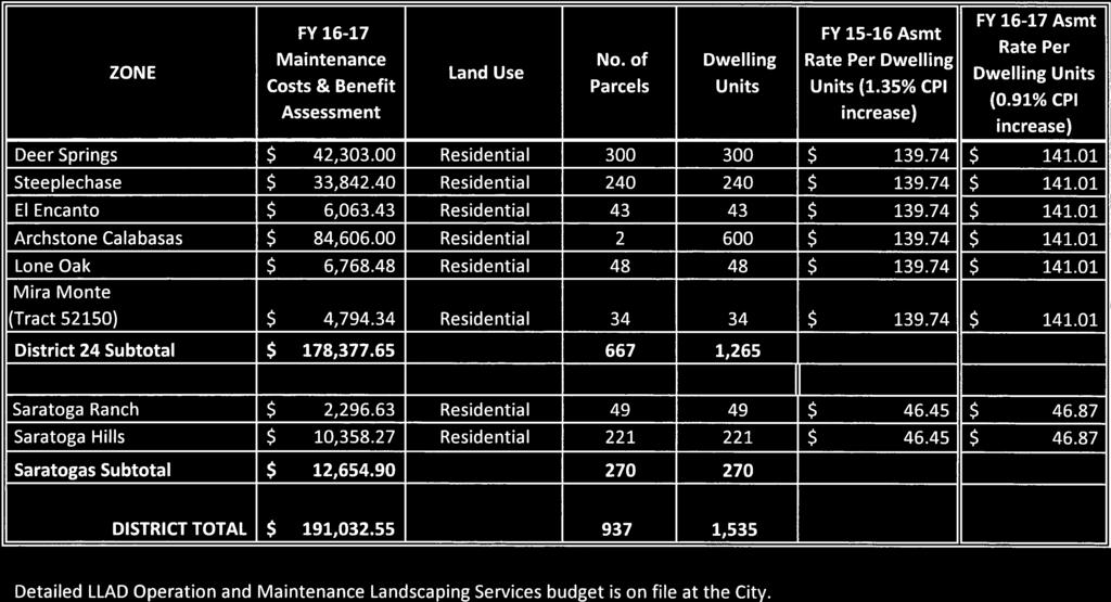
17 Archstone Calabasas Deer Springs El Encanto Lone Oak Mira Monte Saratoga Hills Saratoga Ranch Steeplechase Residential Parcels within the District all receive direct and special benefit. All of the parcels in this District are residential and each parcel is assigned 1 Assessment Unit per parcel. Public Agency parcels within the District that have people working on the premises and have parkway landscape maintained by the District that benefit from the landscape improvements to their parkway maintenance, similar to other parcels. However, at this time, there are no Public Agency parcels in LLAD 24. Homeowner's Association and Common Area parcels within the District are not assessed. These parcels include large park parcels, small sliver parcels, and parking lot parcels that cannot be developed. These unbuildable parcels do not receive a special benefit from the District s improvements and are not assessed. In many cases, the common area parcels provide the same use and function that the District funded improvements provide. In addition, the parcel owners paying the Homeowner's Association bill are already paying for the District s funded improvements by their parcel s assessment. The common area property is incidental to the primary residential parcels. Therefore, the assessment will go directly to the source and assess the properties that benefit from the Zone s improvements and maintenance. The assessment per assessment unit is determined by dividing the total aggregate levy by Zone by the number of assessment units in the Zone. The assessment per parcel is determined by multiplying the assessment per assessment unit by the number of units assigned to the parcel. See Exhibit B for the Landscape Lighting Act District No. 24 (1972 Act) Assessments by Zone. For example, a Zone that only has residential parcels is assigned 1 assessment unit per parcel, and the assessment per parcel is calculated as follows: Zone Total Levy Amount Zone Total Assessment Units (Parcels) = Assessment Amount per Unit (Parcel) 15 P age
18 LANDSCAPE LIGHTING ACT DISTRICT NO. 27 (1972 ACT DISTRICT) (LAS VIRGENES) METHOD OF APPORTIONMENT OF ASSESSMENTS For Fiscal Year , the assessments in Landscape Lighting Act District No. 27 (LLAD 27) will be levied at the same rate as in Fiscal Year plus a 0.91% CPI annual inflation adjustment. For the Fiscal Year , the City of Calabasas, at the request of Mont Calabasas member homeowner association (HOA) Board of Directors, proposes annexing Mont Calabasas HOA Zone into Landscaping Lighting District No. 27 (LLAD27). In compliance with Proposition 218, the proposed annexation into the District and assessment will be submitted to the property owners via mailed ballots. The ballots will be tabulated June and reported at the June 22,2016 Council Meeting to determine if there is a majority protest against the proposed annexation. IMPROVEMENTS LLAD 27 provides maintenance of landscape within street right-of-way. Maintenance of landscape on streets within right-of-way includes parkway, center medians, and street trees. The area of landscape improvements generally referred to as Las Virgenes Road are: On Las Virgenes Road, the east sidewalk and center medians beginning at 3560 Las Virgenes Road and continuing north to Thousand Oaks Blvd.; on Las Virgenes Road north of Thousand Oaks Blvd., the east sidewalk area north to the end of Las Virgenes Rd.; at the northwest corner of Thousand Oaks Blvd. and Ruthwood Drive the public right-of-way area located immediately behind the sidewalk; on the south side of Thousand Oaks Blvd., the sidewalk area from Las Virgenes Road to the flood control channel; and the sidewalk area on the north side of Thousand Oaks Blvd. from Las Virgenes Road to Ruthwood Drive. For the proposed Mont Calabasas HOA Zone into LLAD 27, the improvements include the maintenance of Las Virgenes Road as described above and in addition, provides for the maintenance of landscape of common areas and open space areas located within the Zone. The HOA common areas are either owned in common or privately owned, with easements granted to the District for landscape maintenance purposes. The maintenance of landscape also includes greenbelt and slope areas as well as annual weed abatement/brush clearance for fuel reduction/fire safety. Improvement means one or any combination of the following: The installation or planting of landscape; The installation of trees; The installation or construction of statuary, fountains, or other ornamental structures; The installation or construction, of public lighting facilities (by City policy limited to lighting of parkland and major landscaping); The installation or construction of facilities which are appurtenant to any of the foregoing or which are necessary or convenient for the maintenance and servicing thereof, including, but not limited to grading, clearing, removal of debris, the installation or construction of curbs, gutters, sidewalks, walls, or paving, or water, irrigation, drainage or electrical facilities; The maintenance or servicing, or both, of any of the foregoing; The acquisition of any existing improvement otherwise authorized pursuant to section of the Streets and Highways Code. 16 P age
19 Maintenance means the furnishing of services and materials for the ordinary and usual maintenance, operation, and servicing of any improvement, including: Repair, removal or replacement of all or any part of any improvement; The removal of weeds, trimmings, rubbish, debris, and other solid waste from landscape or hardscape; Cleaning and sandblasting to remove or cover graffiti; Landscape rodent and pest control; Providing for the life, growth, health, and beauty of landscaping, including cultivation, irrigation, trimming, spraying, fertilizing, or treating for plant disease or injury; Trimming or removal of trees. Servicing means the furnishing of: Water for the irrigation of any landscaping, the operation of any fountains or the maintenance of any other improvements; Electrical to power irrigation systems, fountains, and landscape lighting. METHODOLOGY The following methodology described pertains to Landscape Lighting Act District No. 27 (1972 Act) herein referred to in this section as LLAD 27. GENERAL BENEFIT/SPECIAL BENEFIT The local landscape improvements provide special benefits to the properties within those developments, and have no benefit to the public at large, to individuals rather than property, or to properties located outside of the district. The landscape improvements within the street right-of-way located within the District are of direct and special benefit to the assessed properties. Consequently, 100% of these costs are allocated to special benefit. The special benefits of landscape maintenance are described earlier in this Report. Other residential areas of the City that are not included in an assessment district receive a minimal standard of City-funded landscape maintenance. The standard City performed landscape for arterial streets in the City includes minimal median and parkway landscape maintenance. The City policy, therefore, is to have fronting property in the District fund the enhanced landscape maintenance, operation, and servicing of arterial streets. The parcels in the District are funding only the cost of their frontage landscape maintenance. As a result, there is no General Benefit from the funded improvements. Special Benefit Proposed Mont Calabasas HOA Zone Annexation. The proposed Mont Calabasas HOA Zone special benefit includes the maintenance of landscape within Las Virgenes Road street right-of-way. In addition, the special benefit also includes areas to be maintained by LLAD 27 which are either owned in common or are privately owned and are solely accessible to (or primarily accessible to) owners of the assessed properties, their tenants, and/or guests. These areas have easements granted to LLAD 27 for landscape maintenance purposes. The local landscape improvements associated within the Mont Calabasas HOA Zone, provide special benefits to the properties within the Mont Calabasas HOA, and have no benefit to the public at large, to individuals rather than property, or to properties located outside of the district. The landscape improvements of the common areas located within the member homeowner association are of direct and special benefit to the assessed properties. Consequently, 100% of these costs are allocated to 17 P age
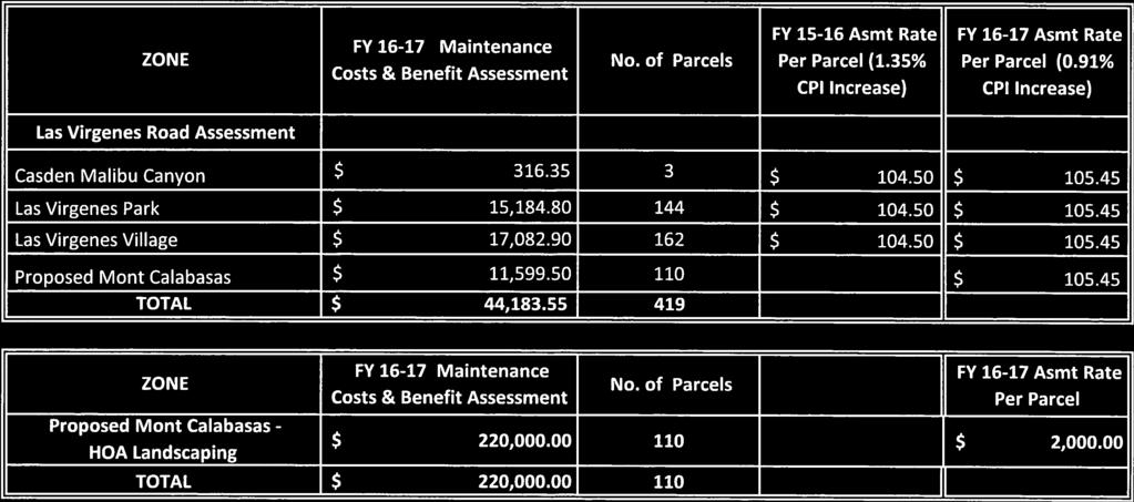
20 special benefit. The specific usage and landscape maintenance activities were identified to determine the level of special benefit each property receives within the Mont Calabasas HOA Zone. FORMULA OF ASSESSMENT In order for the methodology to be in compliance with Articles Xlll C and XIII D enacted by Proposition 218, in a thorough study of the landscape provided to zones of benefit within the District was performed. Specific usage and services were identified for each Zone to determine the level of benefit received by each Zone within LLAD 27. The District was divided into naturally bounded neighborhoods, usually by tracts, but sometimes by street boundaries, and each parcel is assigned 1 assessment unit. The Zones are as follows: Casden Malibu Canyon LP Las Virgenes Park Las Virgenes Village Proposed Mont Calabasas Public Agency parcels within the District that have people working on the premises and have parkway landscape maintained by the District that benefit from the landscape improvements to their parkway maintenance, similar to other parcels. There are no Public Agency parcels in LLAD 27 at this time. Homeowner's Association and Common Area parcels within the District that are not assessed. These parcels include large park parcels, small sliver parcels, and parking lot parcels that cannot be developed. These unbuildable parcels do not receive a special benefit from the District s improvements and are not assessed. In many cases, the common area parcels provide the same use and function that the District funded improvements provide. In addition, the parcel owners paying the Homeowner's Association bill are already paying for the District s funded improvements by their parcel s assessment. The common area parcel is incidental to the primary residential parcels. Therefore, the assessment will go directly to the source and assess the parcels that benefit from the Zone s improvements and maintenance. Assessment Formula - Las Virgenes Road Total Levy The following Zones receive special benefit: Casden Malibu Canyon LP, Las Virgenes Park, Las Virgenes Village and proposed Mont Calabasas. The assessment per assessment unit (parcel) is determined by dividing the total aggregate levy by the total number of assessment units (parcels) in the Zones. Assessment Formula Proposed Mont Calabasas Zone-Total Levy Costs of services for maintaining Mont Calabasas landscape of common areas and open space areas located and specific to Mont Calabasas HOA Zone are spread only across the parcels in that Zone. Each developed residential parcel within the Zone is allocated an equal share of costs applicable to that zone. The assessment per assessment unit (parcel) is determined by dividing the total aggregate levy by the total number of assessment units (parcels) in the Zone. For example, a Zone that only has residential parcels is assigned 1 assessment unit per parcel, and the assessment per parcel is calculated as follows: Zone Total Levy Amount = Assessment Amount per Unit (Parcel) Zone Total Assessment Units (Parcels) See Exhibit C for the Landscape Lighting Act District No. 27 (1972 Act) Assessments by Zone. 18 P age
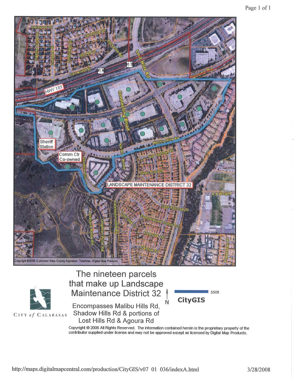
21 CITY OF CALABASAS LANDSCAPE LIGHTING ACT DISTRICT NO. 32 (1972 ACT DISTRICT) (AGOURA ROAD / LOST HILLS ROAD COMMERCIAL DISTRICT) METHOD OF APPORTIONMENT OF ASSESSMENTS For the Fiscal Year , the assessments in Landscape Lighting Act District No. 32 (LLAD 32) will be levied at the same rate as in Fiscal Year plus a 0.91% annual CPI inflation adjustment. IMPROVEMENTS LLAD 32 provides maintenance of landscape within street right-of-way. Maintenance of landscape of street medians and street trees. The landscape improvements maintained by the District are located on the major streets serving the Lost Hills Commercial Area, including Agoura Road from the west side of Malibu Hills Road to the eastern boundary of Agoura Road, Malibu Hills Road, Shadow Hills Road, and the portion of Lost Hills Road from Interstate 101 to the south side of Malibu Hills Road. LLAD 32 provides for funding for the installation, maintenance, operation, and administration of the following landscape improvements: Improvement means one or any combination of the following: The installation or planting of landscape; The installation of trees; The installation or construction, of public lighting facilities (by City policy limited to lighting of parkland and major landscaping); The installation or construction of facilities which are appurtenant to any of the foregoing or which are necessary or convenient for the maintenance and servicing thereof, including, but not limited to grading, clearing, removal of debris, the installation or construction of curbs, gutters, sidewalks, walls, or paving, or water, irrigation, drainage or electrical facilities; The maintenance or servicing, or both, of any of the foregoing; The acquisition of any existing improvement otherwise authorized pursuant to section of the Streets and Highways Code. Maintenance means the furnishing of services and materials for the ordinary and usual maintenance, operation, and servicing of any improvement, including: Repair, removal or replacement of all or any part of any improvement; The removal of weeds, trimmings, rubbish, debris, and other solid waste from landscape or hardscape, Cleaning and sandblasting to remove or cover graffiti; Landscape rodent and pest control; Providing for the life, growth, health, and beauty of landscaping, including cultivation irrigation, irrigation, trimming, spraying, fertilizing, or treating for plant disease or injury; Trimming or removal of trees. Servicing means the furnishing of: Water for the irrigation of any landscaping, the operation of any fountains or the maintenance of any other improvements; 19 P age
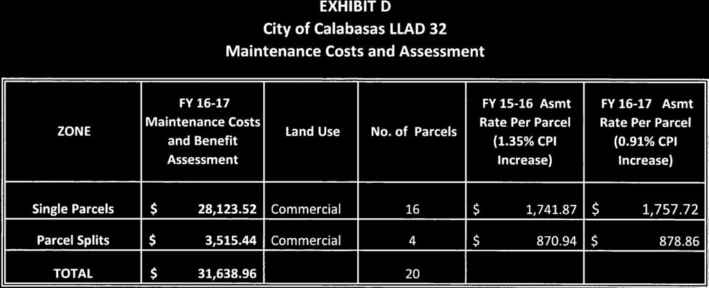
22 Electrical to power irrigation systems, fountains, and landscape lighting. METHODOLOGY The following methodology described pertains to the Landscape Lighting Act District No. 32 (1972 Act) herein referred to in this section as LLAD 32. GENERAL BENEFIT/SPECIAL BENEFIT The local landscape improvements provide special benefits to the properties within those developments, and have no benefit to the public at large, to individuals rather than property, or to properties located outside of the district. The landscape improvements of the common areas located within member homeowner associations are of direct and special benefit to the assessed properties. Consequently, 100% of these costs are allocated to special benefit. The special benefits of landscape maintenance are described earlier in this Report. FORMULA OF ASSESSMENT In order for the methodology to be in compliance with Articles XIII C and Xlll D enacted by Proposition 218, in a thorough study of the landscape provided to the District was performed. Specific usage and services were identified to determine the level of benefit each parcel within the District receives. These costs are apportioned to each parcel based on the Special Benefit associated with the type of land use. Two land uses exist in LLAD 32: Commercial and Public Agency (a sheriff station and a community center). Because there is basically a single land use in the District, commercial, each parcel is assigned 1 assessment unit. The assessment levy is spread equally to each parcel. The only nonconforming land use in the District is related to the Community Center, which is owned by the City of Calabasas and the City of Agoura Hills. The Community Center parcel's frontage landscape will be funded by the District, similar to the commercial properties in the District. Therefore, the Community Center benefits from the assessment and will be assessed as a parcel. Common Area or Easement parcels within the District include primarily open space parcels that cannot be developed and parking lots that are considered unbuildable. These parcels do not receive special benefit and will not be assessed. In many cases, the common area parcels provide the same use and function that the District funded improvements provide. Furthermore, these parcels are incidental to the primary parcels. Therefore, the assessment will go directly to the source and assess the parcels that benefit from the Districts improvements and maintenance. The assessment per assessment unit is determined by dividing the total aggregate levy by parcel by the number of assessment units in the District. The assessment per parcel is determined by multiplying the assessment per assessment unit by the number of units assigned to the parcel. See Exhibit D for the Landscape Lighting Act District No. 32 (1972 Act) Assessments by parcel. For example, a District that only has commercial land use parcels is assigned 1 assessment unit per parcel, and the assessment per parcel is calculated as follows: District Total Levy Amount = Assessment Amount per Unit (Parcel) District Total Assessment Units (Parcels) 20 P age
23 ASSESSMENT ROLL The proposed amounts of assessment for the Fiscal Year Landscape Lighting Act Districts are apportioned to each parcel as shown on the latest roll at the County of Los Angeles Assessor s office and submitted in a separate document titled City of Calabasas Landscaping Lighting Act District Nos. 22, 24, 27 and 32 Assessment Rolls on file with the City Clerk. In conclusion, it is my opinion that the assessments within the City of Calabasas Landscape Lighting Act District Nos. 22, 24, 27, and 32 are apportioned by a formula that fairly distributes special benefit assessments in accordance with the special benefits that are received by each parcel. ENGINEER'S REPORT SUBMITTED BY: Robert Yalda, PE., TE R.C.E. No June 22, P age
24 CITY OF CALABASAS LANDSCAPE AND LIGHTING DISTRICTS FINAL ENGINEER S REPORT FISCAL YEAR ANNEXATIONS AND DETACHMENTS Annexation of territory to an existing assessment district is provided by the 1972 Act, commencing with Section The 1972 Act further provides that an assessment district may consist of contiguous or non-contiguous areas. Annexation proceedings are limited to the territory proposed to be annexed. The history of annexations and detachments are listed as follows: LLAD 22 (1972 ACT DISTRICT) For fiscal year, fifteen (15) parcels located in the City of Calabasas were annexed into the Commercial Area, Calabasas Road. The Assessor Parcel Numbers are as follows: For fiscal year, Zone 15, Park Sorrento Condominium HOA was detached from LLAD 22. For fiscal year, Zone 18, Calabasas Ridge HOA was detached from LLAD 22. LLAD 24 (1972 ACT DISTRICT) For fiscal year, Mira Monte (Tract No ) (Assessor s Parcel No and its successor parcels) was annexed into LLAD 24. For fiscal year, Zone, Calabasas View HOA, was detached from LLAD 24. For fiscal year, two hundred seventy (270) parcels in Saratoga Ranch and Saratoga Hills HOAs were annexed into LLAD 24. LLAD 27 (1972 ACT DISTRICT) For , Mont Calabasas Zone is proposed to be annexed into the District per Proposition 218 proceedings. LLAD 32 (1972 ACT DISTRICT) For fiscal year, Mira Monte (Tract No ) (Assessor s Parcel No and its successor parcels) was detached from LLAD 32 and annexed into LLAD P age
25 EXHIBITS A, B, C, & D LANDSCAPE LIGHTING ACT DISTRICTS (1972 ACT DISTRICTS) MAINTENANCE COSTS AND ASSESSMENTS BY ZONES
26
27

28
29
30 EXHIBIT E DISTRICT NO. 22 ASSESSMENT RATES HISTORY
31 CITY OF CALABASAS LANDSCAPE LIGHTING ACT DISTRICT NO. 22 (LLAD 22) HISTORY - ASSESSMENT RATES Fiscal Year Prop 218 Assessment Increases & Annual CPI Increases Per Parcel Bellagio Calabasas Country Estates Calabasas Hills Classic Calabasas Park Calabasas Park Estates Calabasas Ridge (Detached frfom District ) Cal Road Commercial / Old Town Master Plan Area Formed ) Clairidge (Formed ) Creekside (Detached from District ) Las Villas Oak Creek Oak Park Palatino Park Sorrento (Detached from District ) The Oaks of Calabasas The Oaks II (Vacant land, Asmt per acre) N/A N/A N/A , per acre 2, NAP , per acre 2, NAP , per acre 2, NAP , per acre 2, NAP Prop Majority Vote Yes Yes Yes No Yes Yes Yes Final Asmts , Not Assessed 3, NAP , Prop Majority Vote Yes Final Asmts , per acre 3, NAP , , per acre 3, NAP , , per acre 3, NAP , , per acre 3, NAP , Prop Majority Vote Yes No Yes Yes No Final Asmts , per acre 3, NAP 1, , Prop Majority Vote No No Final Asmts & CPI increase for all Zones , , per acre 3, NAP 1, N/A. All land developed - The Oaks Vista Pointe Westridge 1, Prop Majority Vote Yes Yes No No Yes Final Asmts & CPI increase for all Zones , , per acre 3, NAP 1, , , Prop Majority Vote No Final Asmts & CPI increase for all Zones , , per acre 3, NAP 1, NAP , , Prop Majority Vote No Yes Final Asmts for all Zones (no CPI increase) , , per acre 3, NAP 1, NAP , , Asmts for all Zones (no CPI increase) , , per acre 3, NAP 1, NAP , , Survey Ballot Ridge voted to be Removed from LLAD 22 NAP Asmts for all Zones (2.67 % CPI increase) , NAP , NAP 1, NAP , , Asmts for all Zones (2.03 % CPI increase) , NAP , NAP 1, NAP , , Prop Majority Vote YES Asmts for all Zones (1.08 % CPI increase) $ $ 1, $ $ $ NAP $ $ 3, NAP $ 1, $ $ $ NAP $ $ 1, $ 1, Prop Majority Vote Yes No Asmts for all Zones (1.35 % CPI increase) $ $ 1, $ $ $ 1, NAP $ $ 3, NAP $ 1, $ $ $ NAP $ $ 1, $ 1,598.91
32 EXHIBIT F LANDSCAPE LIGHTING ACT DISTRICTS BOUNDARY DIAGRAM
33
: 1.61Ac _ LOT eoundant s ea 8M~t g~j~j~~y.a~f:b9xtf>.")
34 5.'.:...; LANDSCAPE CITY OF CALABASAS LIGHTING ACT DISTRICT (MALIBU LOST HILLS) NO. 24 LEGEND ~ PLANTED C=="",. CREEK ~ PARK (TURF): 8.5 Ac. STREET. AREA: 6.0 Ac. TREES :mmunmmrnmr B WELLS: 345 FLANTEOMEDIANS 8\ PARKWAYS SLOPE:2.53Ac. (TURF): 1.61Ac _ LOT eoundant s ea 8M~t g~j~j~~y.a~f:b9xtf>.tate QUANTITIES 5- CONTr-WLLERS 70-VALVES HEADS t -~I (NOSCALEI ()..4.(,.,~.~ l.. "'"'f i C.... IJ.,..,j. ~m e, CA.1<IO-'1 tl1:u':.4"ll~4qtlj~-ojll
35


36
37
CITY OF CALABASAS PRELIMINARY ENGINEER S REPORT. LANDSCAPE LIGHTING ACT DISTRICTS NOS. 22, 24, 27 & 32 (1972 Act Districts) FISCAL YEAR
 FISCAL YEAR") CITY OF CALABASAS PRELIMINARY ENGINEER S REPORT LANDSCAPE LIGHTING ACT DISTRICTS NOS. 22, 24, 27 & 32 (1972 Act Districts) FISCAL YEAR 2012-13 Landscape Lighting Act District No. 22 (CALABASAS PARK AREA)
CITY OF CALABASAS PRELIMINARY ENGINEER S REPORT LANDSCAPE LIGHTING ACT DISTRICTS NOS. 22, 24, 27 & 32 (1972 Act Districts) FISCAL YEAR 2012-13 Landscape Lighting Act District No. 22 (CALABASAS PARK AREA)
ENGINEER'S REPORT FOR CITY OF WESTLAKE VILLAGE LANDSCAPE MAINTENANCE ASSESSMENT DISTRICT NO. 1 FISCAL YEAR
 ENGINEER'S REPORT FOR CITY OF WESTLAKE VILLAGE LANDSCAPE MAINTENANCE ASSESSMENT DISTRICT NO. 1 FISCAL YEAR 2017-2018 A. BACKGROUND The Los Angeles County Board of Supervisors established landscape maintenance
The maximum amounts shown in the Engineer s Report for each of those categories for FY 2008/09 are as follows (per house/per year):
:") Agenda Item No. August 28, 2007 TO: FROM: SUBJECT: Honorable Mayor and City Council Attention: David J. Van Kirk, City Manager Dale I. Pfeiffer, Director of Public Works RESOLUTION INITIATING PROCEEDINGS,
Agenda Item No. August 28, 2007 TO: FROM: SUBJECT: Honorable Mayor and City Council Attention: David J. Van Kirk, City Manager Dale I. Pfeiffer, Director of Public Works RESOLUTION INITIATING PROCEEDINGS,
City of Atwater. Landscape Maintenance Districts 2017/18 CONSOLIDATED ENGINEER S REPORT. Intent Meeting: June 12, 2017 Public Hearing: July 10, 2017
 Landscape Maintenance Districts 2017/18 CONSOLIDATED ENGINEER S REPORT Intent Meeting: June 12, 2017 Public Hearing: July 10, 2017 27368 Via Industria Suite 200 Temecula, CA 92590 T 951.587.3500 800.755.6864
CITY OF LAFAYETTE ENGINEER S REPORT LANDSCAPE AND LIGHTING DISTRICT NO (CORE AREA) FISCAL YEAR 2013/2014
 FISCAL YEAR 2013/2014") CITY OF LAFAYETTE ENGINEER S REPORT LANDSCAPE AND LIGHTING DISTRICT NO. 1979-1 (CORE AREA) FISCAL YEAR 2013/2014 INTENT MEETING: APRIL 22, 2013 PUBLIC HEARING: MAY 28, 2013 27368 Via Industria Suite 110
CITY OF LAFAYETTE ENGINEER S REPORT LANDSCAPE AND LIGHTING DISTRICT NO. 1979-1 (CORE AREA) FISCAL YEAR 2013/2014 INTENT MEETING: APRIL 22, 2013 PUBLIC HEARING: MAY 28, 2013 27368 Via Industria Suite 110
City of Richmond. Marina Bay Landscaping and Lighting Maintenance District. 2018/2019 Engineer s Annual Levy Report
 City of Richmond Marina Bay Landscaping and Lighting Maintenance District 2018/2019 Engineer s Annual Levy Report Intent Meeting: May 22, 2018 Public Hearing: June 19, 2018 27368 Via Industria Suite 200
REPORT TO MAYOR AND COUNCIL
 REPORT TO MAYOR AND COUNCIL AGENDA ITEM NO. 5.a TO THE HONORABLE MAYOR AND COUNCIL: DATE: May 26, 2015 SUBJECT: ADOPT RESOLUTION NOS. 15-33, 15-34, 15-35, AND 15-36, CONFIRMING THE ASSESSMENT DIAGRAMS
REPORT TO MAYOR AND COUNCIL
 AGENDA ITEM NO..e REPORT TO MAYOR AND COUNCIL TO THE HONORABLE MAYOR AND COUNCIL: DATE: March 1, 1 SUBJECT: ADOPTING RESOLUTION NOS. 1-, 1-, 1-, and 1- ORDERING THE PREPARATION OF THE ENGINEER S REPORT
City of Coachella. Final Engineer s Report
 Engineer s Annual Levy Report Landscaping and Lighting Maintenance Assessment Districts 1 through 38 Fiscal Year 2013/2014 Final Engineer s Report City of Coachella Engineering Department 1515 Sixth Street
CITY OF YUBA CITY STAFF REPORT
 CITY OF YUBA CITY STAFF REPORT Agenda Item 9 Date: February 19, 2013 To: From: Presentation by: Honorable Mayor & Members of the City Council Public Works Department George Musallam, Public Works Director
Agenda Item No. May 27, Honorable Mayor and City Council Attention: David J. Van Kirk. Dale I. Pfeiffer, Director of Public Works
 Agenda Item No. May 27, 2008 TO: FROM: SUBJECT: Honorable Mayor and City Council Attention: David J. Van Kirk Dale I. Pfeiffer, Director of Public Works RESOLUTION GRANTING PRELIMINARY APPROVAL OF THE
KASPER. City of Georgetown, Texas PUD Planned Unit Development. December 30, 2015 Revised January 27, 2016
 KASPER City of Georgetown, Texas PUD Planned Unit Development December 30, 2015 Revised January 27, 2016 Applicant: Sentinel Land Company, LLC 4910 Campus Drive Newport Beach, CA Prepared by: SEC Planning
2 Project Description
 Project Description 2 Project Description The proposed project would involve the demolition of the existing church and the construction of 40 twostory single family residences. The residential lots would
IMPACT ON FINANCIAL AND PERSONNEL RESOURCES:
 MEMORANDUM TO: FROM: CITY COUNCIL GEOFF ENGLISH, PUBLIC WORKS DIRECTOR SUBJECT: CONSIDERATION OF ADOPTION OF RESOLUTIONS ORDERING THE PREPARATION AND FILING OF ANNUAL ENGINEER S REPORTS FOR THE PARKSIDE
2.0 AREA PLANS. Lakeside Business District. Lakeside Business District Land Use Categories:
 Lakeside Business District Lakeside Business District Land Use Categories: Campus Commercial Campus Commercial means a mixture of uses which includes corporate offices, office parks, hotels, commercial,
STORMWATER UTILITY FREQUENTLY ASKED QUESTIONS
 STORMWATER UTILITY FREQUENTLY ASKED QUESTIONS What is Stormwater? Stormwater is water that falls to the ground during a precipitation event. When land is undeveloped or covered with vegetative surface,
STORM WATER UTILITY FREQUENTLY ASKED QUESTIONS
 STORM WATER UTILITY FREQUENTLY ASKED QUESTIONS In 2007, the City Council adopted Ordinance No. 1155 establishing a storm water utility in the City. No fee structure was adopted at that time. The idea of
MEETING DATE: November 12, 2013 SUBJECT: Accept Borden Road Bridge Improvement (CIP No )
") AGENDA REPORT Meeting of the San Marcos City Council MEETING DATE: November 12, 2013 SUBJECT: Accept Borden Road Bridge Improvement (CIP No. 88165) Recommendation Staff recommends the City Council adopt
AGENDA REPORT Meeting of the San Marcos City Council MEETING DATE: November 12, 2013 SUBJECT: Accept Borden Road Bridge Improvement (CIP No. 88165) Recommendation Staff recommends the City Council adopt
RRW Stonebrook, LLC Tentative Map Findings
 RRW Stonebrook, LLC Tentative Map Findings FINDING T1: The request conforms to the Master Plan and zoning ordinances. RELATIONSHIP TO THE MASTER PLAN 1. The respective development is located within an
A date error was corrected on the signature line of the distributed Engineer' s Report. Attached are the reports with the corrected date.
 ow v MEETING DATE: 05/ 05/ 15 ITEM NO: 6 cos s 0g ADDENDUM COUNCIL AGENDA REPORT DATE: MAY 4, 2015 TO: MAYOR AND TOWN COUNCIL FROM: LES WHITE, INTERIM TOWN MANA SUBJECT: LANDSCAPING AND LIGHTING. DISTRICTS
Chapter Purpose and Intent. 7.2 Applicability. 7.3 General Provisions RECREATIONAL OPEN SPACE
 Chapter 7. RECREATIONAL OPEN SPACE 7.1 Purpose and Intent The intent of this Chapter is to provide for centrally located, unencumbered land as neighborhood recreational open space and not to permit the
Coco Palms Community Development District. Engineer s Report Infrastructure Improvements
 Coco Palms Community Development District Engineer s Report Infrastructure Improvements Prepared for Coco Palms Community Development District Board of Supervisors Miami-Dade County, Florida Prepared by
Planning Commission Staff Report June 5, 2008
 Owner/Applicant Taylor Village Sacramento Investments Partners, LP c/o Kim Whitney 1792 Tribute Road #270 Sacramento, CA 95815 Staff Recommendation Planning Commission Staff Report Project: File: Request:
Plan Policies. Introduction
 Plan Policies Introduction The purpose of the Plan Policies section is to identify the various Governing Body and Planning Commission land use related policy resolutions for use in evaluating development
The purpose of the requirements in this Article is to provide for landscaping and screening of parking and other outdoor areas that will:
 XIII. LANDSCAPING & SCREENING A. Purpose The purpose of the requirements in this Article is to provide for landscaping and screening of parking and other outdoor areas that will: 1. Protect residential
CITY OF ZEELAND PLANNING COMMISSION
 APPLICATION FOR SITE PLAN REVIEW AND SPECIAL LAND USE Date City Official App. Filing Fee Rec'd ($350) NOTE TO APPLICANT: Please submit this application for Site Plan Review along with twenty (20) copies
Planning Commission Staff Report March 15, 2007
 Planning Commission Staff Report Project: Request: Madeira East Tentative Subdivision Map, Design Review for Subdivision Layout & Abandonment of Easements Location: Phase IV of the Laguna Ridge Specific
LANDSCAPE STANDARDS PURPOSE AND INTENT OF LANDSCAPE ORDINANCE
 LANDSCAPE STANDARDS COMMUNITY DEVELOPMENT DEPARTMENT / PLANNING DIVISION 8130 Allison Avenue, La Mesa, CA 91942 Phone: 619.667-1177 Fax: 619.667-1380 PURPOSE AND INTENT OF LANDSCAPE ORDINANCE The regulations
Improve the appearance of off-street parking areas, vehicular use areas, and property abutting public and private roads;
 Bedford Township, MI (Monroe Co.) 2012 http://library.municode.com/index.aspx?clientid=02123 400.1907 - Landscaping and screening. Se 1907. 1. Intent. Landscaping, greenbelts, and screening are necessary
Town of Yucca Valley Capital Improvement Projects Report July 24, 2014
 Town of Yucca Valley Capital Improvement Projects Report July 24, 2014 SR 62 Traffic and Pedestrian Improvements from Apache Trail to Palm Avenue (PLHD) The project includes construction of curbs, gutters,
A BILL FOR AN ORDINANCE TO AMEND CHAPTER 9, KAUAI COUNTY CODE 1987, RELATING TO STREET REQUIRE:MENTS FOR SUBDIVISIONS
 ORDINANCE NO. BILL NO. { vy"yj1j A BILL FOR AN ORDINANCE TO AMEND CHAPTER 9, KAUAI COUNTY CODE 1987, RELATING TO STREET REQUIRE:MENTS FOR SUBDIVISIONS BE IT ORDAINED BY THE COUNCIL OF THE COUNTY OF KAUA'I,
The transportation system in a community is an
 7 TRANSPORTATION The transportation system in a community is an important factor contributing to the quality of life of the residents. Without a sound transportation system to bring both goods and patrons
7.0 OPEN SPACE 7.1 OPEN SPACE DEDICATION CHAPTER 7: OPEN SPACE
 7.0 OPEN SPACE The intent of these requirements is to allow for the usage of centrally located unencumbered land as neighborhood open spaces and not to permit the use of leftover or otherwise unusable
GENERAL INFORMATION What is Stormwater? What is a stormwater utility? What is an impervious surface?
 GENERAL INFORMATION What is Stormwater? Stormwater is rain or snowmelt that falls on streets, parking areas, rooftops, and other developed land and either flows directly into nearby streams or travels
Authority of the General Plan
 Authority of the General Plan This La Habra Heights General Plan will serve as the blueprint for future planning and development in the City. This General Plan describes the City s vision for the future
SECTION UNIFIED DEVELOPMENT ORDINANCE SECTION Part 1 Ordinance. ARTICLE 1 Zoning Districts
 SECTION 1-100 UNIFIED DEVELOPMENT ORDINANCE SECTION 1-300 Part 1 Ordinance SECTION 1-100. Introduction. ARTICLE 1 Zoning Districts Crystal Lake strives to maintain a balance of various land uses for a
CITY OF CYPRESS 5275 Orange Avenue Cypress, California (714) DESIGN REVIEW COMMITTEE PERMIT PROCESS
 DESIGN REVIEW COMMITTEE PERMIT PROCESS") CITY OF CYPRESS 5275 Orange Avenue Cypress, California 90630 (714) 229-6720 DESIGN REVIEW COMMITTEE PERMIT PROCESS 1. Discuss project with Planning staff to determine zoning regulations, any unusual characteristics
CITY OF CYPRESS 5275 Orange Avenue Cypress, California 90630 (714) 229-6720 DESIGN REVIEW COMMITTEE PERMIT PROCESS 1. Discuss project with Planning staff to determine zoning regulations, any unusual characteristics
ARTICLE 17 SITE PLAN REVIEW
 ARTICLE 17 SITE PLAN REVIEW 17.01 INTENT AND PURPOSE The intent of this section is to provide for consultation and cooperation between the applicant and the township planning commission so that the applicant
CITY PLANNING COMMISSION AGENDA ITEM: C STAFF: ROBERT TEGLER FILE NO: CPC PUD QUASI-JUDICIAL
 CPC AGENDA June 8, 2006 Page 37 CITY PLANNING COMMISSION AGENDA ITEM: C STAFF: ROBERT TEGLER FILE NO: CPC PUD 05-294 - QUASI-JUDICIAL PROJECT: APPLICANT: OWNER: PARKWOOD AT WOLF RANCH NASS DESIGN ASSOCIATES
PLANNED UNIT DEVELOPMENT & SUBDIVISION STAFF REPORT Date: May 18, 2017
 & PUD-0000102-2017 PLANNED UNIT DEVELOPMENT & SUBDIVISION STAFF REPORT Date: May 18, 2017 NAME SUBDIVISION NAME Dauphin Creek Estates Subdivision Dauphin Creek Estates Subdivision LOCATION CITY COUNCIL
PLANNING COMMISSION. Submitted
 PLANNING COMMISSION City Hall 1275 Main Street El Centro, CA 92243 Submitted PLANNING COMMISSION ACTION ITEM (1844) Meeting: 05/10/16 12:00 AM Department: Community Development Category: Public Hearing
LOS ANGELES CITY PLANNING DEPARTMENT STAFF REPORT
 LOS ANGELES CITY PLANNING DEPARTMENT STAFF REPORT LOS ANGELES CITY PLANNING COMMISSION CASE NO: CPC 2006-9374 CRA CEQA: Exempt DATE: December 21, 2006 Location: Valley Plaza and Laurel Plaza TIME: after
LAND USE TANGLEWILDE/THOMPSON PLACE PLANNING AREA. C. Identified Neighborhood Groups and Homeowner s Associations
 LAND USE TANGLEWILDE/THOMPSON PLACE PLANNING AREA I. Profile of Tanglewilde/Thompson Place Planning Area (Revised 3/5/02) A. Location The Tanglewilde/Thompson Place Planning Area is located just east of
ORDINANCE WHEREAS, this Ordinance is consistent with the City of Winter Garden Comprehensive Plan; and
 ORDINANCE 17-06 AN ORDINANCE OF THE CITY COMMISSION OF THE CITY OF WINTER GARDEN, FLORIDA, CREATING ARTICLE XIV OF CHAPTER 118 OF THE CITY OF WINTER GARDEN CODE OF ORDINANCES PROVIDING FOR THE EAST PLANT
City of Yorba Linda Memorandum
 City of Yorba Linda Memorandum Date: June 15, 2011 Date: To: From: Honorable Chairman and Members of the Parks and Recreation Commission Mike Kudron, Acting Director of Parks and Recreation SUBJECT: BACKGROUND
Exhibit A. 8:9 Scuffletown Rural Conservation District
 Exhibit A 8:9 Scuffletown Rural Conservation District 8:9.1 Intent and Purpose The Scuffletown Rural Conservation (SRC) District is intended to provide for residential development that supports the development
ADOPTED CAPITAL IMPROVEMENT PROGRAM BUDGET ARROYO PROJECTS
 ADOPTED CAPITAL IMPROVEMENT PROGRAM BUDGET ARROYO PROJECTS HAHAMONGNA FY 212-216 Capital Improvement Program Priority Description Total Estimated Costs Appropriated Through FY 211 Adopted FY 212 FY 213
PC RESOLUTION NO
 PC RESOLUTION NO. 14-01-14-02 TENTATIVE TRACT MAP fttm) 17441. REZONE {RZ) 13-003, ARCHITECTURAL CONTROL (AC) 13-003, TREE REMOVAL PERMIT (TRP) 13-052. GRADING PLAN MODIFICATION (GPM) 13-002. CONDITIONAL
LANDSCAPE ORDINANCE PASADENA PLANNING DEPARTMENT (713) FAX (713)
 FAX (713)") LANDSCAPE ORDINANCE PASADENA PLANNING DEPARTMENT (713) 475-5543 FAX (713) 477-1072 ARTICLE X. LANDSCAPING OF NONRESIDENTIAL SITES* Sec. 9-195. Applicability. (a) This article shall apply to the following:
LANDSCAPE ORDINANCE PASADENA PLANNING DEPARTMENT (713) 475-5543 FAX (713) 477-1072 ARTICLE X. LANDSCAPING OF NONRESIDENTIAL SITES* Sec. 9-195. Applicability. (a) This article shall apply to the following:
CITY OF MANHATTAN BEACH STAFF REPORT. THROUGH: Marisa Lundstedt, Director of Community Development
 CITY OF MANHATTAN BEACH STAFF REPORT TO: Planning Commission THROUGH: Marisa Lundstedt, Director of Community Development FROM: Tony Olmos, Director of Public Works DATE: April 29, 2015 SUBJECT: Determination
13. PRELIMINARY PLAT NO MILLS FARM - Vicinity of the southeast corner of 159 th Street and Quivira Road
 13. corner of 159 th Street and Quivira Road 1. APPLICANT: HNTB Corporation is the applicant for this request. 2. REQUESTED ACTION: The applicant is requesting approval of a preliminary plat for a 383-lot
Retail Signage Options. Planning Commission Special Meeting February 19, 2015
 Retail Signage Options Planning Commission Special Meeting February 19, 2015 1 Agenda Todays PC Workshop Structure: 1) Review of current shopping center locations 2) General Plan and Code Review 3) Provide
Section 3 INVENTORY OF RECREATION LAND AND FACILITIES
 Photo of Juan Bautista de Anza Park Section 3 INVENTORY OF RECREATION LAND AND FACILITIES Summary of Findings Park Definitions Summary of Recreation Facilities Other Recreation Facilities Nearby Recreation
Advance Engineering & Surveying PLLC
 Advance Engineering & Surveying, PLLC Consulting in: Civil & Environmental Engineering Land Surveying Land Development 11 Herbert Drive Phone: (518) 698-3772 Latham, N.Y. 12110 Email:ncostape@gmail.com
ARTICLE IX SPECIAL PERMIT USES
 ARTICLE IX SPECIAL PERMIT USES All special permit uses cited in Article IX and Attachment A of this Ordinance or any other Section of this Ordinance shall be subject to Site Plan Review. The procedures
ARROYO PROJECTS ADOPTED CAPITAL IMPROVEMENT PROGRAM BUDGET
 A RROYO P ROJECTS ADOPTED CAPITAL IMPROVEMENT PROGRAM BUDGET FISCAL YEARS 214-218 HAHAMONGNA Priority Description 1 Hahamongna Watershed Park - Implement Master Plan 211,6 211,6 (77565) 2 Hahamongna -
4.1.3 LAND USE CATEGORIES
 4.1.3 LAND USE CATEGORIES a. City Center District The City Center District incorporates the existing character and mix of uses in downtown Belmont to encourage redevelopment and new development in keeping
Glenborough at Easton Land Use Master Plan
 Implementation 114 9.0 IMPLEMENTATION 9.1 OVERVIEW This chapter summarizes the administrative procedures necessary to implement the proposed land use plan, infrastructure improvements, development standards,
STAFF REPORT TO THE CITY COUNCIL. Conduct Public Hearing to vacate certain public right of way adjacent to Sycamore Avenue and San Pablo Avenue
 STAFF REPORT TO THE CITY COUNCIL DATE: Adjourned Regular Meeting of December 16, 2014 TO: SUBMITTED BY: SUBJECT: Mayor and Members of the City Council Holly Smyth, Planning Director Conduct Public Hearing
C. WATER. 1. Surface Water Runoff. See Section C.3, Flood Hazard/Mudflow Hazard, page Ground Water
 C. WATER 1. Surface Water Runoff See Section C.3, Flood Hazard/Mudflow Hazard, page 67. 2. Ground Water Determined not significant by the October 1984 and January 1999 Initial Studies conducted by the
HAZARD MITIGATION GOALS AND OBJECTIVES
 SEWRPC Community Assistance Planning Report No. 282, 2nd Edition CITY OF MILWAUKEE ALL HAZARDS MITIGATION PLAN UPDATE Chapter IV HAZARD MITIGATION GOALS AND OBJECTIVES [NOTE: Throughout this plan update
ARTICLE IV: DEVELOPMENT STANDARDS 404 MASTER PLANNING
 IV 13 404 MASTER PLANNING Master Planning through the Site Analysis (Master Planning Site Analysis) or Planned Development (Master Planning Planned Development) is provided to encourage development which
Planning Districts INTRODUCTION
 INTRODUCTION To facilitate detailed examination of development prospects for all areas of the community, Delano has been divided into 14 planning districts. The location of these planning districts is
The Town Board of the Town of Vienna, County of Dane, State of Wisconsin, does ordain and adopt as follows.
 ORDINANCE DRIVEWAYS AND CULVERTS NO. 6-5-06 ORDINANCE CONCERNING DRIVEWAY AND CULVERT REQUIREMENTS 1-1-1 Driveway Permits; Culvert Requirements 1-1-2 Driveway and Culvert Location, Design and Construction
Proposed Walkability Ordinance for City of Knoxville (6/16/17)
") Proposed Walkability Ordinance for City of Knoxville (6/16/17) New or revised text is highlighted Section 1: Purpose The purpose of this ordinance is to set requirements for walkability and pedestrian
Proposed Walkability Ordinance for City of Knoxville (6/16/17) New or revised text is highlighted Section 1: Purpose The purpose of this ordinance is to set requirements for walkability and pedestrian
Major Subdivision Sketch Plan Checklist
 This checklist provides specific requirements that are apart of the Sketch process. The entire process is described by the Huntersville Subdivision Review Process which details all the submittal and resubmittal
NOTICE OF PREPARATION
 NOTICE OF PREPARATION DATE: January 6, 2016 TO: LEAD AGENCY: Responsible Agencies, Organizations, and Interested Parties Contact: Tyler Barrington, Principal Planner Planning Department Community Development
TIRZ 17/Redevelopment Authority Capital Improvements Plan Projects
 Gessner Widening: T-1701 What: Widen the road from a six-lane divided boulevard to an eight-lane divided boulevard street section, increase turn lanes, update traffic signal system, improve drainage by
North Oakville East Parks Facilities Distribution Plan. November, 2009
 North Oakville East November, 2009 POLICY CONTEXT 1) Purpose a) The purpose of this document is to be a guide for the location, configuration, design and development of the parks system for the North Oakville
Access Management: An Overview
 Figures 1-5 Below Evolution of development along a highway. In the early stages, land along the road is used for farming with little traffic generated. As time passes, the highway corridor becomes a de
The Illinois Department of Transportation and Lake County Division of Transportation. Route 173, including the Millburn Bypass
 The Illinois Department of Transportation and Lake County Division of Transportation welcome you to this Public Hearing for U.S. Route 45 from Illinois Route 132 to Illinois Route 173, including the Millburn
Baumgarten MPUD. Exhibit 3 Evaluation Criteria
 Pursuant to LDC subsections 10.02.13 B, 10.02.08 F and Chapter 3 G. of the Administrative Code, staff s analysis and recommendation to the Planning Commission, and the Planning Commission s recommendation
Right-of-Way Acquisitions and Relocations Technical Memorandum
 Right-of-Way Acquisitions and Relocations Technical Memorandum Southeast Extension Project Lincoln Station to RidgeGate Parkway Prepared for: Federal Transit Administration Prepared by: Denver Regional
Application Number: SD Project Name: Walton Farms Preliminary Subdivision (acting as Master Plan)
") STAFF REPORT Town of Clayton Planning Department 111 E. Second Street, Clayton, NC 27520 P.O. Box 879, Clayton, NC 27528 Phone: 919-553-5002 Fax: 919-553-1720 Planning Board May 22, 2017 Application Number:
STAFF REPORT Town of Clayton Planning Department 111 E. Second Street, Clayton, NC 27520 P.O. Box 879, Clayton, NC 27528 Phone: 919-553-5002 Fax: 919-553-1720 Planning Board May 22, 2017 Application Number:
Prepared by: Casey Kempenaar, Senior Planner
 CITY OF CITRUS HEIGHTS PLANNING DIVISION STAFF REPORT PLANNING COMMISSION MEETING September 13, 2017 Prepared by: Casey Kempenaar, Senior Planner REQUEST The applicant requests a Design Review Permit Modification
Town of Castle Rock DRCOG 2013 Annual Growth and Development Report. Introduction. Section 1 Metro Vision 2035
 Town of Castle Rock DRCOG 2013 Annual Growth and Development Report Introduction This is the Town of Castle Rock s sixth annual report to the Denver Regional Council of Governments (DRCOG) reporting on
DESIGN AND LANDSCAPE GUIDELINES FOR DEVELOPMENT
 DESIGN AND LANDSCAPE GUIDELINES FOR DEVELOPMENT IN THE SECOND SUPERVISORIAL DISTRICT (REVISED) ADOPTED BY RIVERSIDE COUNTY BOARD OF SUPERVISORS ON SEPTEMBER 15, 1998 REVISED OCTOBER 23, 1998 REVISED AUGUST
TOWN OF APPLE VALLEY TOWN COUNCIL STAFF REPORT
 TOWN OF TOWN COUNCIL STAFF REPORT To: Honorable Mayor and Town Council Date: July 24, 2018 From: Brad Miller, Town Engineer Item No: 8 Engineering Department Subject: LIGHTING AND LANDSCAPE ASSESSMENT
TOWN OF HILLSBOROUGH SAN MATEO COUNTY
 TOWN OF HILLSBOROUGH SAN MATEO COUNTY Planning Division 650/375-7422 Fax: 650/375-7415 1600 Floribunda Avenue Hillsborough California 94010 Administrative Review of Landscape Plans April 2017 WHAT TYPES
MEMORANDUM OF UNDERSTANDING REGARDING MANAGEMENT OF THE LAKE MERCED TRACT
 June 24, 2011 Draft MEMORANDUM OF UNDERSTANDING REGARDING MANAGEMENT OF THE LAKE MERCED TRACT THIS MEMORANDUM OF UNDERSTANDING ("MOU"), dated for reference purposes only as of, 2011, is entered into by
Hidden Pointe Landscape Master Plan. June, archi terra
 Hidden Pointe Landscape Master Plan June, 2006 t h e archi terra g r o u p 1 Table of Contents Background Purpose and Goals of the Master Plan Master Plan Process Existing Conditions Entrance Hidden Pointe
SECTION 39. Title V, Chapter 6, Article 2, added to the Zoning Code of Sacramento County shall read as follows: GREENBACK LANE SPECIAL PLANNING AREA
 SECTION 39. Title V, Chapter 6, Article 2, added to the Zoning Code of Sacramento County shall read as follows: GREENBACK LANE SPECIAL PLANNING AREA 506-20. INTENT. It is the intent of the Board of Supervisors
3. VISION AND GOALS. Vision Statement. Goals, Objectives and Policies
 Vision Statement Queen Creek s interconnected network of parks, trails, open spaces and recreation opportunities provide safe and diverse activities and programs that sustain its unique, small town, equestrian
CONFORMED AGREEMENT INCORPORATED REVISIONS PER AMENDMENT DATED: APRIL 2, 2013 FOR REFERENCE
 CONFORMED AGREEMENT INCORPORATED REVISIONS PER AMENDMENT DATED: APRIL 2, 2013 FOR REFERENCE CITY STREETS AS PART OF STATE HIGHWAYS GUIDELINES REACHED BY THE WASHINGTON STATE DEPARTMENT OF TRANSPORTATION
RECREATION AND OPEN SPACE ELEMENT GOALS, OBJECTIVES, AND POLICIES
 RECREATION AND OPEN SPACE ELEMENT GOALS, OBJECTIVES, AND POLICIES Goal 7 To provide park facilities, recreation programs, and open space resources that are safe, adequate, and accessible to all City residents,
The following principles guide the development of goals and strategies to protect and promote these amenities:
 OPEN SPACE/PARKS/TRAILS/RECREATION GOALS/STRATEGIES Cherry Hills Village is a living environment that offers low density development, open areas, public scenic vistas, public trails and public parks. This
CITY OF SIMI VALLEY MEMORANDUM
 CITY OF SIMI VALLEY MEMORANDUM AGENDA ITEM NO. 9.1 May 18, 2016 TO: FROM: Planning Commission Department of Environmental Services SUBJECT: REVIEW OF POTENTIAL FISCAL YEAR (FY) 2016-17 CAPITAL IMPROVEMENT
LAND USE AMENDMENT CORNERSTONE (WARD 3) COUNTRY HILLS BOULEVARD AND STONEY TRAIL NE BYLAW 9D2017
 COUNTRY HILLS BOULEVARD AND STONEY TRAIL NE BYLAW 9D2017") Page 1 of 12 EXECUTIVE SUMMARY This Land Use Amendment application covers an area of 54.92 hectares ± (135.71 acres ±) located in northeast Calgary, bound by Country Hills Boulevard NE to the north and
Page 1 of 12 EXECUTIVE SUMMARY This Land Use Amendment application covers an area of 54.92 hectares ± (135.71 acres ±) located in northeast Calgary, bound by Country Hills Boulevard NE to the north and
CITY OF HOLLY SPRINGS STORMWATER UTILITY FREQUENTLY ASKED QUESTIONS
 CITY OF HOLLY SPRINGS STORMWATER UTILITY FREQUENTLY ASKED QUESTIONS GENERAL What is a Stormwater Utility and why is it needed in Holly Springs? A Stormwater Utility is an entity responsible for the daily
VALLEY COUNTY MINIMUM STANDARDS FOR PRIVATE ROAD DESIGN AND CONSTRUCTION
 MINIMUM STANDARDS FOR PRIVATE ROAD DESIGN AND CONSTRUCTION Adopted November 28, 2005 TABLE OF CONTENTS DEFINITION OF TERMS...II I. DESIGN CRITERIA... 1 A. GENERAL DESIGN CRITERIA... 1 B. ROADWAY CLASSIFICATION...
CITY OF RIFLE, COLORADO ORDINANCE NO. 31 SERIES OF 2003
 CITY OF RIFLE, COLORADO ORDINANCE NO. 31 SERIES OF 2003 AN ORDINANCE OF THE CITY OF RIFLE, COLORADO, REPEALING AND REENACTING CHAPTER 26, TITLE 16 OF THE RIFLE MUNICIPAL CODE REGARDING STREET NAMING AND
MONTGOMERY COUNTY PLANNING DEPARTMENT THE MARYLAND-NATIONAL CAPITAL PARK AND PLANNING COMMISSION
 MONTGOMERY COUNTY PLANNING DEPARTMENT THE MARYLAND-NATIONAL CAPITAL PARK AND PLANNING COMMISSION MCPB Item No. Date: 12-10-15 Leisure World Clubhouse II Addition Fitness Center, Limited Site Plan Amendment
SPECIFIC PLAN Requirements
 CITY OF LANCASTER PLANNING DEPARTMENT 44933 Fern Avenue, Lancaster, California 93534 (661) 723-6100 SPECIFIC PLAN Requirements Purpose The purpose of a specific plan is to provide for the logical development
The following specific definitions shall apply to the landscaping and screening regulations contained in this article:
 ARTICLE XII. LANDSCAPING Sec. 5-421. Purpose. The purpose of landscaping and screening requirements is to improve certain setback and yard areas, including off-street vehicular parking and open-lot sales
1.0 Circulation Element
 5/9/18 1.0 Circulation Element 1.1 Introduction As growth and development occur in Apache County, enhancements to its circulation system will be necessary. With time, more roads will be paved and air and
MEMORANDUM HONORABLE MAYOR AND CITY COUNCIL MEMBERS. SHERI REPP LOADSMAN, DEPUTY CITY MANAGER/ PLANNING & BUILDING DIRECTOR /s/
 MEMORANDUM Agenda Item #: 13 Meeting Date: 9/12/17 TO: THRU: FROM: SUBJECT: HONORABLE MAYOR AND CITY COUNCIL MEMBERS ANTON DAHLERBRUCH, CITY MANAGER /s/ SHERI REPP LOADSMAN, DEPUTY CITY MANAGER/ PLANNING
Environmental Protection Ordinances (Performance Zoning) Bedminster Township, Bucks County
 Bedminster Township, Bucks County") Environmental Protection Ordinances (Performance Zoning) Bedminster Township, Bucks County ARTICLE VI. PERFORMANCE STANDARDS Section 600 Compliance All uses, activities, subdivisions and/or land developments
Environmental Protection Ordinances (Performance Zoning) Bedminster Township, Bucks County ARTICLE VI. PERFORMANCE STANDARDS Section 600 Compliance All uses, activities, subdivisions and/or land developments
Meridian Hills Improvements
 Meridian Hills Improvements Public Information Meeting Background The Town Planning Committee - ad hoc committee established December 2005 Volunteer members Create a long-range plan of improvements that
Town of Portola Valley General Plan. Nathhorst Triangle Area Plan
 Town of Portola Valley General Plan Amended December 10, 1997 Table of Contents Introduction... 1 Planning Area... 1 Objectives... 2 Principles... 2 Standards... 4 Description... 4 Community Commercial...
TOWN OF APPLE VALLEY TOWN COUNCIL STAFF REPORT
 TOWN OF TOWN COUNCIL STAFF REPORT To: Honorable Mayor and Town Council Date: June 26, 2018 From: Brad Miller, Town Engineer Item No: 5 Engineering Department Subject: LIGHTING AND LANDSCAPE ASSESSMENT