3.10 LAND USE PLANNING
|
|
|
- Leon Calvin Hubbard
- 5 years ago
- Views:
Transcription
1 3.10 LAND USE PLANNING Introduction The term land use refers to the use of land for various activities, including commercial, industrial, recreational, agricultural, and residential uses. Local land use policies and development regulations control the type of land use and the intensity of development permitted. New development can be incompatible with existing land uses if it creates noise, excessive traffic, odor, safety hazards, visual impacts, or other environmental impacts that disturb existing uses. Land use planning is designed to, among other things, prevent such incompatibilities. This section of the Program EIR examines the Program s potential land use impacts. The section discusses in general terms the existing land uses throughout the Program area, and applicable land use plans and policies intended to regulate development in the area. The section also addresses the types of land use impacts that could occur under the Program, and mitigation measures that would reduce these potential impacts to less-than-significant levels Environmental Setting Table describes general categories of land uses that occur within the LAUSD boundaries, and provides examples of specific land uses within each category. Table Land Use Classifications Classification or Examples of Land Uses Land Use Type Agriculture Farm Field (irrigated or non-irrigated cropland), Orchard, Wholesale Nursery Commercial and Retail Store, Shopping Center, Professional Office, Business Park, Retail Plant Nursery, Commercial Services Storage, Hotels and Motels Educational Pre-School, Early Education Center, Elementary School, Middle School, Junior High School, Senior Institutions High School, Colleges, Universities, Trade Schools Manufacturing Facility, Motion Picture and Television Studio Lots, Mineral Extraction, Oil Well, Oil Refinery, Tank Farm, Substation, Gravel Pit, Concrete Plant, Landfill, Sewer Plant, Transmission Line Significant Ecological Areas, Environmentally Sensitive Habitat, Wildlife Refuge, River, Stream or Open Space and Floodplain, Vacant Urban Land, Coastal Bluffs, Non-Recreational Area, General Rural Land, Golf Recreation Course, Local or Regional Park, Cemetery, Beaches, Cultural Center, Museum, Campground, Fairgrounds, Golf Course, Playground Government Offices, Police and Sheriff Stations, Fire Stations, Major Medical Health Care Facilities, Religious Facilities, Non-Attended Public Parking Facilities, Correctional Facilities Single-Family Residences, Multi-Family Residences such as Condominium or Apartment, Townhouse, Mobile Home Park Freeways and Major Roads, Airports, Railroads, Harbor Facilities, Park and Ride Lots, Bus and Truck Terminals Elementary, Middle/Junior High, High School, College, University, Adult Education, Trade School, Day Care, Academy, Religious Facility, Cemetery, Hospital, Convalescent Hospital, Rest Home, Sensitive Land Use Rehabilitation Center, Nursing Home, Children s Health Center, Recreation Facility, Research/Scientific Uses, and all Land Uses Source: SCAG, 2003a. LAUSD New School Construction Program Land Use Planning
2 Surrounded by ocean, mountains, cities, and suburbs, the Program area covers 704 square miles of urban southern California. The LAUSD is a highly urbanized area, containing the City of Los Angeles and its 35 Community Plan Areas (LADCP, 2002), all or portions of 25 other cities, and several unincorporated areas of Los Angeles County (LAUSD, 2003). Table sets forth all of the city and county jurisdictions within the LAUSD by local district. LAUSD Local District A B Table Land Use Type by Local District Neighborhood/Jurisdiction/Place City of LA Community Plan Areas: -Canoga Park-Winnetka-Woodland Hills -Chatsworth-Porter Ranch -Granada Hills-Knollwood -Mission Hills-Panorama City-North Hills -Northridge Valley Area County of Los Angeles City of LA Community Plan Areas: -Arleta-Pacoima -North Hollywood-Valley Village -Sherman Oaks-Studio City-Toluca Lake-Cahuenga Pass -Sun Valley-La Tuna Canyon -Sunland-Tujunga-Lake View Terrace-East La Tuna Canyon -Sylmar Land Use Types Open Space and Recreation Open Space and Recreation Designated Land Area 80% 8% 6% 3% 68% 15% 7% 5% 3% C City of San Fernando County of Los Angeles City of LA Community Plan Areas: -Canoga Park-Winnetka-Woodland Hills -Encino-Tarzana -North Hollywood-Valley Village -Northridge -Reseda-West Van Nuys -Sherman Oaks-Studio City-Toluca Lake-Cahuenga Pass -Van Nuys-North Sherman Oaks Open Space and Recreation 8 6% 5% 4% 0% D County of Los Angeles City of LA Community Plan Areas: -Los Angeles World Airport -Bel-Air-Beverly Crest -Brentwood-Pacific Palisades -Venice -West Adams-Baldwin Hills-Leimert -West Los Angeles -Westchester-Playa del Rey -Westwood -Wilshire Central Area Open Space and Recreation 79% 6% 6% 4% 3% City of Beverly Hills City of El Segundo City of Santa Monica City of West Hollywood County of Los Angeles LAUSD New School Construction Program Land Use Planning
3 LAUSD Local District E F H G I J Neighborhood/Jurisdiction/Place City of LA Community Plan Areas: -Hollywood -Northeast Los Angeles -West Adams-Baldwin Hills-Leimert -Wilshire City of West Hollywood County of Los Angeles City of LA Community Plan Areas: -Central City -Central City North -Northeast Los Angeles -Westlake County of Los Angeles City of LA Community Plan Areas: -Boyle Heights -Central City North -Southeast Los Angeles City of Commerce City of Montebello City of Monterey Park County of Los Angeles City of LA Community Plan Areas: -South Los Angeles -West Adams-Baldwin Hills-Leimert City of Hawthorne City of Inglewood City of Lynwood County of Los Angeles City of LA Community Plan Areas: -Southeast Los Angeles County of Los Angeles City of Bell City of Bell Gardens City of Commerce City of Cudahy City of Downey City of Huntington Park City of Lynwood City of Maywood City of South Gate City of Vernon County of Los Angeles South Area Land Use Types Open Space and Recreation (Griffith Park) Open Space and Recreation Educational institutions Open Space and Recreation Open Space and Recreation Open Space and Recreation Open Space and Recreation Designated Land Area 75% 9% 8% 4% 3% 0% 57% 18% 1 7% 34% 3 23% 7% 70% 9% 8% 7% 4% 3% 59% 18% 9% 8% 3% 36% 3 2 8% 0% LAUSD New School Construction Program Land Use Planning
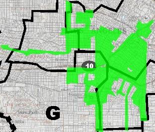
4 LAUSD Local District K Neighborhood/Jurisdiction/Place City of LA Community Plan Areas: -Harbor Gateway -Port of Los Angeles -San Pedro -Wilmington-Harbor City City of Carson City of Gardena City of Lomita City of Long Beach City of Rancho Palos Verdes City of Torrance County of Los Angeles Land Use Types Open Space and Recreation Designated Land Area Note: Jurisdictions, Neighborhoods, and Places may be listed more than once if they are within multiple local districts. Sources: ZIMAS, 2003 / SCAG 2003a. 50% 10% 10% 6% 3% The predominant land use in nearly every LAUSD local district is residential housing. There are also significant commercial, industrial, transportation, and open space uses throughout the Program area. Table (Land Use Type by Local District) provides an overview of the predominant land use types within each local district. Figure (Land Use Types within the LAUSD Boundaries) illustrates the land use types occurring district-wide (SCAG, 2003a). Figures , , and provide a more detailed description of land uses by acreage within each local district of the Valley, Central, and South areas, respectively. Figure shows the percentage of each land use type occurring within the district. (Note: Figures are at the end of Section 3.10.) In addition, the Community Redevelopment Agency (CRA) of the City of Los Angeles has established redevelopment project areas throughout the City to eliminate blight and revitalize depressed regions (CRA, 2003a). All the LAUSD local districts contain some CRA redevelopment project areas within their boundaries. However, redevelopment areas are largely concentrated in the eastern half of the Central study area. Figure illustrates all CRA redevelopment project areas within the boundaries of the LAUSD. Valley Area The predominant land use throughout the Valley is residential housing, with interspersed areas of open space and recreation, industry, transportation, and commercial uses. Educational institutions and public facilities are also present. Figure illustrates the land use types and patterns occurring within the Valley area. While housing occurs throughout the Valley, open space and recreational uses are concentrated in the eastern half of Local District B (San Gabriel Mountains), the northwest portion of Local District A (Santa Susana Mountains), and Local Districts C and B (the Sepulveda and Hansen Dam Recreation Areas, respectively). In addition, smaller parks and recreational uses are scattered throughout the Valley. and LAUSD New School Construction Program Land Use Planning
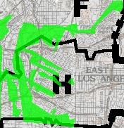
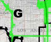
5 transportation uses lie along the railroad right-of-way at the border of Local Districts A and C, between Interstates 5 and 405. These uses extend along the northern border of Local District C with the southeastern border of Local District A. In the Valley, CRA redevelopment project areas occur primarily in the Laurel Canyon portion of the Hollywood Freeway (State Route 170 Local District B), the North Hollywood area (Local District B), and the western San Fernando Valley neighborhoods of Canoga Park, Reseda, and Winnetka (Local Districts A and C). Central Area The Central area of the LAUSD, which contains much of downtown Los Angeles, is denser and more urbanized than the Valley (see Figure ). As in the Valley, the predominant land use in the Central area is residential housing. The western half of the area is predominantly low-density housing with large tracts of open space in the Santa Monica Mountains, while the eastern half contains urban residential areas mixed with industrial and commercial uses. Local District D, representing the western half of the Central area, consists mainly of single- and multi-family housing, commercial uses along the major east-west corridors (such as Wilshire, Olympic, and Pico Boulevards), and open space and recreation uses. These open space and recreation uses include the Santa Monica Mountains National Recreation Area, Topanga State Park, Will Rogers State Historic Park, and the beaches along the Pacific Ocean. Local District D also includes the Los Angeles International Airport and related transportation and industrial uses. Local District E is mainly residential, with significant open space and recreation uses in the area of Griffith Park. Local District F includes much of downtown Los Angeles, and contains commercial and service uses, light and heavy industry, and public facilities in greater concentrations than most other areas of the LAUSD. In addition to housing, the central portion of Local District H contains a substantial amount of industrial land. CRA redevelopment project areas in the Central study area occur mainly in the eastern portion of the study area in downtown Los Angeles. Much of downtown Los Angeles is within or near a CRA redevelopment project area. A large area of redevelopment is located in and around Hollywood, consisting of the Hollywood Redevelopment and the East Hollywood/Beverly-Normandie Earthquake Disaster Assistance Projects. South Area The South area is more industrialized than the Valley or Central areas (see Figure ). areas are concentrated near downtown Los Angeles (in the northern portion of Local District J), along the Interstate 110 (I-110) and Interstate 710 (I-710) corridors (Local District K), and in the Harbor region (Local District K). The Harbor area contains concentrated transportation uses in addition to serving as the terminus for the I-110 and I-710 transportation LAUSD New School Construction Program Land Use Planning
6 and industrial corridors. The I-110 and I-710 corridors cross many of the cities comprising the LAUSD s southeastern region. In addition, the South area contains considerable commercial uses dispersed along major arterial roads throughout the area. The South area has two major regions containing CRA redevelopment project areas: downtown Los Angeles (south of I-10) and the Port of Los Angeles. CRA project areas in downtown Los Angeles concentrate in the northern portion of Local Districts G and I and spread southward along major roads. In the Port of Los Angeles, CRA redevelopment projects areas occur along the western edge of the Los Angeles Harbor Applicable Regulations, Plans, and Standards Because this is a first-tier assessment of a program that will cover some 704 square miles, this Program EIR does not attempt to identify every land use plan and policy that is potentially applicable. Specific project locations have not been identified, so the applicability of plans and policies cannot be precisely determined. Moreover, applicable land use plans and policies within the LAUSD could be revised during the course of the Program. California Department of Education School Site Selection and Approval Guide Education Code and the CCR Title 5, through outline the CDE s authority for approving proposed school sites and constructing school buildings. CDE must approve each site in order for that site to receive State acquisition funds under the School Facilities Program administered by the State Allocation Board (CDE, 2003). According to the CDE School Site Selection and Approval Guide, some of the many factors that affect school site selection include health and safety, location, size, and cost. The School Facilities Planning Division (SFPD) has developed screening and ranking procedures applied during the site selection process. The criteria used during the LAUSD site selection are listed in detail in the Project Description in Section (Site Selection). California Coastal Act The California Coastal Act constitutes the California Coastal Management Program for the purposes of the Federal Coastal Zone Management Act (California Coastal Act of 1976, PRC et seq.). The Act established the California Coastal Commission (CCC), identified a designated California Coastal Zone, and established the CCC s responsibility to include the preparation and on-going oversight of a Coastal Plan for the protection and management of the Coastal Zone. Each local jurisdictional authority (city or county) with lands within the coastal zone is required to develop, and comply with, a coastal management plan. The Coastal Act requires that any person or public agency proposing development within the Coastal Zone obtain a Coastal Development Permit (CDP) from either the Commission, or the city or county having the jurisdictional authority to issue a CDP. New school construction in LAUSD New School Construction Program Land Use Planning
7 portions of the Central and South LAUSD areas could require a CDP. Any construction within the Coastal Zone must conform to the requirements of the California Coastal Act generally, and Chapter 3, Section 6 (Development) specifically (CCC, 2003a). On or near the shoreline, coastal-dependent developments have priority over those uses not dependent on a coastal location (PRC 30255; CCC, 2003a). To comply with the Coastal Zone Management Act, localities develop Local Coastal Plans (LCPs). Table lists LCPs potentially applicable to the LAUSD area. Table Local Coastal Plans within the LAUSD Region Community Date Certified El Segundo 2/4/1982 Long Beach 5/22/1981 Marina del Rey/Ballona 5/10/1995 Pacific Palisades In progress Playa Vista 5/8/1991 Rancho Palos Verdes 4/27/1983 Santa Monica 11/17/1992 Torrance 6/18/1981 Venice 6/12/2001 Source: CCC, 2003b. Communities potentially within the Coastal Zone and in the LAUSD boundaries include El Segundo, Long Beach, Marina del Rey/Ballona, Pacific Palisades, Playa Vista, Rancho Palos Verdes, Santa Monica, Torrance, and Venice. During the site-review process, if the possibility exists that the proposed school site could lie within the Coastal Zone, LAUSD would consult with the applicable local agency to identify local coastal plan or Coastal Act requirements. Southern California Association of Governments Regional Comprehensive Plan and Guide The SCAG is the federally mandated Metropolitan Planning Organization (MPO) for Los Angeles, Orange, San Bernardino, Riverside, Ventura, and Imperial Counties. SCAG s Regional Comprehensive Plan and Guide (RCPG) is a 20-year strategic plan for local and regional development. The RCPG focuses on transportation, housing, growth management, air quality issues, and the local economy (SCAG, 1996). SCAG does not infringe on the land use planning prerogatives of local government. However, SCAG encourages and promotes the coordination and integration of local general plans, subregional plans, and regional plans. State law and State General Plan Guidelines direct cities and counties to refer their proposals for general plan adoptions and substantial amendments to area-wide planning agencies, such as SCAG, for review and comment. The RCPG supports and encourages local government, the subregional agencies, and other affected parties to work together with SCAG to foster a high degree of consistency among plans in order to achieve harmonious planning relationships at all geographic levels (SCAG, 1996). The RCPG consists of three sections: LAUSD New School Construction Program Land Use Planning
8 Core Chapters (Growth Management, Regional Mobility, Air Quality, Water Quality, and Hazardous Waste Management). The Core chapters correspond directly to the federal and State requirements and may also contain non-binding advisory materials and guidance; Ancillary Chapters (Economy, Housing, Human Resources and Services, Public Finance, Open Space and Conservation, Water Resources, Energy, and Integrated Waste Management). The Ancillary chapters may reflect other regional plans but are strictly advisory and establish no new mandates or policies for the region; and Bridge Chapters (Introduction, Strategy, and Implementation). The Bridge chapters show the links between the requirements in the Core chapters and the guidance in the Ancillary chapters for other areas of concern. In summary, the RCPG is a compilation of planning documents for the southern California region. Some of these plans are required by federal or State law; some are prepared by operating agencies that produce them in the course of meeting their obligations; and some respond to the direction of SCAG s Regional Council. SCAG information is useful in policy consistency analysis for regional projects in that it provides a consistent review and evaluation of planning documents and demographic data across multiple jurisdictional boundaries. In a letter dated May 21, 2003, SCAG determined that the Program is not regionally significant within the meaning of the SCAG Intergovernmental Review Criteria and CEQA Guidelines ( 15206) (SCAG, 2003a). LAUSD Regulations for Civic Center Use As mentioned in the Program Description in Section (School Operations), California Education Code (b), the Civic Center Act, permits public use of school facilities. Table outlines organizations and activities that qualify and do not qualify for Civic Center permits. School facilities available for Civic Center use include gyms, playing fields, stadiums, auditoriums, multi-purpose rooms, cafeterias, and classrooms. Facilities are available within designated time frames outside school hours. Organizations wishing to use a school location for a Civic Center use must go through an application/permit process with the LAUSD. A variety of rules, regulations, and restrictions governing the use of school buildings for Civic Center purposes appear in detail on the permit and the application. Table Civic Center Organizations and Uses Qualify for Civic Center Permits Do Not Qualify for Civic Center Permits PTAs For-profit organizations Girl/Boy Scout Troops Swimming pools Senior citizens organizations Private school activities Youth groups Parking lots Recreational activities of clubs and associations concerned Religious services with education, recreation, arts, politics, economics, charity LAUSD New School Construction Program Land Use Planning
9 Qualify for Civic Center Permits Meetings/discussions open to the general public concerned with education, politics, economics, arts, charities, culture, community moral interests Jazzercize Aerobics Jujitsu Ballroom dances sponsored by Youth Services and PTAs or specifically authorized by the Superintendent Good news clubs Source: LAUSD, 1999 (Civic Center Procedure Manual) Do Not Qualify for Civic Center Permits Political campaign headquarters Cultural classes Invitation only and exclusive meetings Tennis courts Roller blading Gymnastics Karate Child care and enrichment programs Wrestling Hammer throwing and discus Non-authorized ballroom dances Picnics Weight lifting CRA Memorandum of Understanding The LAUSD, the City of Los Angeles, and the CRA entered into a MOU to Maximize the Public Benefit from the Construction of New Schools (CRA, 2003b). The MOU is designed to: Maximize the benefit to neighborhoods and their surrounding communities Resolve potential land-use conflicts prior to choosing particular sites and/or project strategies, where and when possible Minimize the duplication of expenditures, including expenditures for planning and community outreach Minimize the number of situations where the actions of any party conflict with or negate the actions of any other party, where and when possible. With this MOU, the LAUSD, City of Los Angeles, and CRA agreed to share information through document and data exchange. The LAUSD agreed to include existing schools and school sites under development in its real estate database and to provide CRA access to reports on the current demographic need locations as well as preferred sites for proposed new schools. The LAUSD also provides information about the Program and describes the status of each new school (i.e., site selected, site control, demolition completed, grading completed, and off-site public infrastructure improvements completed). The LAUSD, City of Los Angeles, and CRA also agreed to exchange information as early as possible and to hold meetings in each of the three study areas (Valley, Central, South) on a regular basis. These meetings serve as a forum to discuss all proposed school development/ expansion activities, to determine whether or not joint use programs may be incorporated into such proposals, and to attempt to arrive at consensus on new school siting and general design (CRA, 2003b). LAUSD New School Construction Program Land Use Planning
10 Local Plans and Policies A General Plan is a basic planning document and acts as a blueprint for development. Every city and county within California is required by State law to adopt a General Plan with seven mandatory elements: land use, circulation, housing, conservation, open space, noise, and safety. Depending on a community s specific needs, General Plans may also contain special topics, such as local coastal plans, waste management, hazardous waste, seismic hazards, floodplain management, or airport land use. City or county zoning codes set forth detailed requirements that implement the General Plan policies at the level of the individual parcel of land. The zoning code presents development standards for different land uses, and identifies which uses are allowed in the various zoning districts of a jurisdiction. California law requires the city or county zoning codes to be consistent with the jurisdiction s General Plan. Table lists potentially applicable local plans and policies governing the cities and places within the LAUSD. Under a general plan and/or zoning ordinance, schools in a particular area will be (1) permitted by right, (2) not permitted, or (3) "conditionally permitted." If schools are permitted by right in a certain area, then a school district need take no action to comply with the general plan or zoning ordinance. Even where schools are not permitted or are conditionally permitted under local land use law, school districts ultimately have the authority to render general plan and zoning requirements inapplicable (Government Code 53094, 65402). Under State law, a school district must submit to the local planning agency the location, purpose, and extent of each proposed school use (Government Code 65402[c]). The Planning Agency may either approve the location, purpose, and extent of a proposed school use as being in conformity with the General Plan, or disapprove the location, purpose, or extent of the school use as being not in conformity with the General Plan. If the Planning Agency disapproves the location, purpose, or extent of the school use as being not in conformity with the General Plan, the school district may nonetheless overrule the disapproval (Government Code [c]). If schools are not permitted or conditionally permitted in a particular zone, a school district s governing body may nonetheless render the general plan or zoning ordinance inapplicable by a two-thirds vote (Government Code 53094; 82 Op. Atty. Gen. 135 [1999]). This vote may be taken at any point in the process. Thus, under State law, the fact that a proposed LAUSD school project is inconsistent with a general plan or zoning ordinance will not prevent LAUSD from proceeding with that project. LAUSD New School Construction Program Land Use Planning
11 LAUSD Local District A B C Table Applicable Planning Documents Planning Document Document Date Website Link Valley Area City of Los Angeles General Plan 5/2/ Framework Element of L.A. General Plan 8/8/ Canoga Park-Winnetka-Woodland Hills- West Hills Community Plan 8/17/ Chatsworth-Porter Ranch Community Plan 7/14/ Granada Hills-Knollwood Community Plan 7/10/ Mission Hills-Panorama City-North Hills Community Plan 6/9/ Northridge Community Plan 2/24/ Los Angeles County General Plan Los Angeles County - Scenic Highway Element General Plan 10/11/ cations City of Los Angeles General Plan 5/2/ Framework Element of L.A. General Plan 8/8/ Arleta-Pacoima Community Plan 11/6/ North Hollywood-Valley Village Community Plan 5/14/ Sherman Oaks-Studio City-Toluca Lake- Cahuenga Pass Community Plan 5/13/ Sun Valley-La Tuna Canyon Community Plan 8/13/ Sunland-Tujunga-Lake View Terrace- Shadow Hills-East La Tuna Canyon Community Plan 11/18/ Sylmar Community Plan 8/6/ San Fernando General Plan 1987 p?entitytype=city&entityid=1449 Los Angeles County General Plan Los Angeles County - Scenic Highway Element General Plan 10/11/ cations City of Los Angeles General Plan 5/2/ Framework Element of L.A. General Plan 8/8/ Canoga Park-Winnetka-Woodland Hills- West Hills Community Plan 8/17/ Encino-Tarzana Community Plan 12/16/ North Hollywood-Valley Village Community Plan 5/14/ Northridge Community Plan 2/24/ Reseda-West Van Nuys Community Plan 11/17/ Sherman Oaks-Studio City-Toluca Lake- Cahuenga Pass Community Plan 5/13/ Van Nuys-North Sherman Oaks Community Plan 9/9/ Los Angeles County General Plan Los Angeles County - Scenic Highway Element General Plan 10/11/ cations LAUSD New School Construction Program Land Use Planning
12 LAUSD Local District D E F Planning Document Document Date Website Link Central Area City of Los Angeles General Plan 5/2/ Framework Element of L.A. General Plan 8/8/ Los Angeles International Airport Community Plan 1/12/ Bel Air-Beverly Crest Community Plan 11/6/ Brentwood-Pacific Palisades Community Plan 6/17/ Venice Community Plan 9/29/ West Adams-Baldwin Hills-Leimert Community Plan 5/6/ m West Los Angeles Community Plan 7/27/ Westchester-Playa Del Rey Community Plan 6/13/ Westwood Community Plan 7/27/ m Wilshire Community Plan 9/19/ Beverly Hills General Plan In process p?entitytype=city&entityid=1092 El Segundo General Plan Santa Monica General Plan Santa Monica Local Coastal Plan 11/17/ Santa Monica Master Environmental Assessment 4/ West Hollywood General Plan In process p?entitytype=city&entityid=1560 Los Angeles County General Plan Los Angeles County - Scenic Highway 10/11/ Element General Plan cations Los Angeles County - Marina del Rey Land Use Plan 1996 City of Los Angeles General Plan 5/2/ cations Framework Element of L.A. General Plan 8/8/ Hollywood Community Plan 12/13/ m Northeast Los Angeles Community Plan 6/15/ West Adams-Baldwin Hills-Leimert Community Plan 5/6/ m Wilshire Community Plan 9/19/ West Hollywood General Plan In process p?entitytype=city&entityid=1560 Los Angeles County General Plan Los Angeles County - Scenic Highway Element General Plan 10/11/ cations City of Los Angeles General Plan 5/2/ Framework Element of L.A. General Plan 8/8/ Central City Community Plan 5/2/ Central City North Community Plan 12/15/ Northeast Los Angeles Community Plan 6/15/ Westlake Community Plan 9/16/ Los Angeles County General Plan LAUSD New School Construction Program Land Use Planning
13 LAUSD Local District H G I J Planning Document Document Date Website Link Los Angeles County - Scenic Highway 10/11/ Element General Plan cations City of Los Angeles General Plan 5/2/ Framework Element of L.A. General Plan 8/8/ Boyle Heights Community Plan 11/10/ Central City North Community Plan 12/15/ Southeast Los Angeles Community Plan 3/22/ Commerce General Plan Montebello General Plan 1973 p?entitytype=city&entityid=1339 Monterey Park General Plan Los Angeles County General Plan Los Angeles County - Scenic Highway Element General Plan 10/11/ cations South Area City of Los Angeles General Plan 5/2/ Framework Element of L.A. General Plan 8/8/ South Los Angeles Community Plan 3/22/ West Adams-Baldwin Hills-Leimert Community Plan 5/6/ Hawthorne General Plan 1989 p?entitytype=city&entityid=1229 Hawthorne Boulevard Specific Plan 1/ Inglewood Consolidated Plan dated_plan/default.asp Garland Village Specific Plan Lynwood General Plan 1991 p?entitytype=city&entityid=1308 Los Angeles County General Plan Los Angeles County - Scenic Highway Element General Plan 10/11/ ations City of Los Angeles General Plan 5/2/ Framework Element of L.A. General Plan 8/8/ Southeast Los Angeles Community Plan 3/22/ Los Angeles County General Plan Los Angeles County - Scenic Highway Element General Plan 10/11/ cations Bell General Plan 1996 p?entitytype=city&entityid=1085 Bell Gardens General Plan 1995 p?entitytype=city&entityid=1086 Commerce General Plan Cudahy General Plan 1992 p?entityid=1157&entitytype=city Downey General Plan 1992 p?entitytype=city&entityid=1175 Downey Landing Specific Plan 2/ Downey Landing EIR In process Downey Landing Firestone Specific Plan 3/ Huntington Park General Plan 1992 p?entitytype=city&entityid=1244 LAUSD New School Construction Program Land Use Planning
14 LAUSD Local District K Planning Document Document Date Website Link Lynwood General Plan 1991 p?entitytype=city&entityid=1308 Maywood General Plan 1989 p?entitytype=city&entityid=1321 South Gate General Plan 1986 p?entitytype=city&entityid=1508 South Gate Business and Park Specific Plan 1986 Plan for the former General Motors facility; please see for more information Vernon General Plan 1989 p?entitytype=city&entityid=1548 Los Angeles County General Plan Los Angeles County - Scenic Highway Element General Plan 10/11/ cations City of Los Angeles General Plan 5/2/ Framework Element of L.A. General Plan 8/8/ Harbor Gateway Community Plan 12/6/ Port of Los Angeles Community Plan 3/22/ San Pedro Community Plan 3/17/ Wilmington-Harbor City Community Plan 7/14/ Carson General Plan In process n/eir.htm Gardena General Plan 1993 p?entitytype=city&entityid=1213 Lomita General Plan 1998 p?entitytype=city&entityid=1296 Long Beach Strategic Plan Rancho Palos Verdes General Plan 6/26/ _EIR/index.htm Rancho Palos Verdes Local Coastal Plan Torrance General Plan 1992 p?entitytype=city&entityid=1529 Los Angeles County General Plan Los Angeles County - Scenic Highway 10/11/ Element General Plan cations For reference purposes, Table identifies planning and guidance documents that are potentially applicable to school projects built under the Program, absent any decisions by the LAUSD s Board of Education to render documents inapplicable. LAUSD would consult this table when performing future, site-specific CEQA review of particular projects Environmental Impacts and Mitigation Measures Thresholds of Significance School construction under the Program would have a significant land use impact if it would: Physically divide established communities Develop a school project that is substantially incompatible with existing or proposed surrounding land uses, due to the size, intensity, density or type of surrounding land uses, and/or the size, intensity, or density of the school project LAUSD New School Construction Program Land Use Planning
15 Create inconsistencies with applicable land use plans adopted for the purpose of avoiding or mitigating an environmental effect, where such inconsistencies evidence underlying significant physical impacts, or Create inconsistencies with adopted regional plans or policies related to growth, where such inconsistencies evidence underlying significant physical impacts Environmental Impact Analysis Impact LU-1: Potential to physically divide an established community. Impact Determination Less than Significant. One of the Program s purposes is to develop neighborhood schools such that children in existing residential areas can attend schools near their homes. Thus, schools would be located in or near residential neighborhoods. When particular sites are proposed, the LAUSD would consider whether and to what extent each proposed school project would divide any established community. Impacts are unlikely in most cases however, because school projects, unlike highways, transmission lines and other aboveground infrastructure, are generally not long enough to provide any significant physical disruption of established communities. Moreover, schools would be attended by members of the community and would therefore serve as important places of community interaction. Neighborhood schools are generally integral parts of their surrounding communities, and therefore do not create or constitute physical divisions. No significant impacts have been identified at this first-tier stage of review. Mitigation Measures. No mitigation is required. Impact LU-2: Develop a school project that is substantially incompatible with existing or proposed surrounding uses, due to the size, intensity, density or type of surrounding land uses, and/or the size, intensity, or density of the school project. Impact Determination Less than Significant. A proposed school project could be incompatible with the surrounding land uses in one of two ways. First, in some cases surrounding land uses could impose unacceptable noise, odor, traffic, health, safety, and/or aesthetic impacts on a school. Second, depending on particular circumstances, it is possible that a school project could impose unacceptable noise, traffic, and/or aesthetic impacts on surrounding land uses. LAUSD will consider the compatibility of each proposed school project with the surrounding land uses when specific sites are proposed. As explained in Section 2.3.3, in compliance with CDE site selection standards, LAUSD will consider whether the existing or proposed zoning of surrounding properties will pose a potential health or safety risk to students or staff (5 CCR 14010[m]). For the most part, land use compatibility impacts will be evaluated in individual CEQA documents within the primary impact categories, such as traffic, noise, parking, LAUSD New School Construction Program Land Use Planning
16 hazards, or aesthetics. The first-tier analysis of these impact categories is set forth elsewhere in this document (Sections 3.1, 3.3, 3.8, and 3.13). Schools are generally compatible with the residential uses and many commercial uses found in the Program area. Schools are intended to serve the local community and would provide an important public resource within the community. No significant impacts have been identified at this first-tier stage of review. Additional review will be conducted during the second-tier stage of review when the LAUSD proposes specific sites for new school construction projects. Mitigation Measures. No mitigation is required. Impact LU-3: Potential inconsistencies with applicable land use plans adopted for the purpose of avoiding or mitigating an environmental effect, where such inconsistencies evidence underlying significant physical impacts. Impact Determination - Less than Significant. In itself, an inconsistency with a plan, policy, or regulation does not constitute a significant impact on the environment. CEQA is concerned with physical changes in the environment. An inconsistency between a project and a plan is a legal determination rather than a physical impact. 1 Where a plan is adopted for the purpose of avoiding or mitigating a physical impact on the environment, however, an inconsistency may be evidence that the project may result in a significant effect on the environment. 2 Thus, the Program will have a significant land use impact when (1) school construction is inconsistent with a land use plan adopted for the purpose of environmental protection, and (2) this inconsistency is evidence of an underlying significant physical impact. The agencies listed in Section (Applicable Regulations, Plans, and Standards) regulate land use, often for the purpose of avoiding or mitigating an environmental effect. The SCAG promotes coordination of local and regional plans and policies to ensure policy consistency and coordinated regional growth. The SCAG has determined that the Program is not regionally significant per SCAG Intergovernmental Review Criteria and CEQA Guidelines (SCAG, 2003b). Therefore, the Program is consistent with applicable SCAG policies. It is unknown whether and to what extent school projects constructed under the Program will conflict with applicable land use plans, because specific sites have not yet been selected. If the LAUSD identifies inconsistencies between proposed school construction projects and applicable land use plans during site-specific reviews, it would consider whether those inconsistencies evidence significant physical impacts that individual projects will create. If the 1 Practice Under the California Environmental Quality Act, Continuing Education of the Bar, Stephen L. Kostka, Michael H. Zischke, Chapter 12, Section 12.36, p (December, 2003). LAUSD New School Construction Program Land Use Planning
17 proposed site is within the Coastal Zone, the LAUSD would coordinate with the applicable local agency to identify local coastal plan or Coastal Act requirements. For the most part, physical impacts will be evaluated in individual CEQA documents within the primary impact categories, such as traffic, noise, parking, hazards, and aesthetics. The first-tier analysis of these impact categories is set forth elsewhere in this document (Sections 3.1, 3.3, 3.8, and 3.13). No significant impacts have been identified at this first-tier stage of CEQA review. Additional review would be conducted during the second-tier stage of review when the LAUSD proposes specific sites for new school construction projects. Mitigation Measures. No mitigation is required. Impact LU-4: Potential inconsistencies with adopted regional growth plans or policies. Impact Determination Less than Significant. The Program would create inconsistencies with adopted regional plans or policies related to growth if it encouraged construction and development contrary to or exceeding regional growth projections and plans. This issue is analyzed in the population and housing section of this document (Section 3.14), which concludes that the Program would not encourage growth. In addition, the SCAG, which reviews the consistency of local plans, projects, and programs with regional plans (see also Section above) (SCAG, 1996), determined that the Program was not regionally significant per SCAG Intergovernmental Review Criteria and CEQA Guidelines (SCAG, 2003b). As a growth-accommodating measure, the Program would not induce growth to create inconsistencies with adopted regional plans or policies, but would rather accommodate the population growth included in regional growth projections. The Program is consistent with regional growth projections and is not inconsistent with any official regional plans or policies related to growth. Therefore, impacts to adopted regional plans or policies related to growth would be less than significant. No significant adverse impacts have been identified during this first-tier stage of CEQA review. Given that the Program accommodates projected growth, and does not induce future growth, no significant impacts with regard to growth policies are expected to occur during the second-tier CEQA review of specific school sites. Mitigation Measures. No mitigation is required. 2 Id. LAUSD New School Construction Program Land Use Planning

18 Open Space/Recreation LAUSD New School Construction Figure Land Use Types within LAUSD Boundaries G Local LAUSD Boundary Districts Within LAUSD Boundary N 0 5 Scale in Miles 10 Aspen Environmental Group LAUSD New School Construction Program Draft Program EIR Source: Adapted from SCAG, 2003a Land Use Planning March 2004

19 A B Open Space/Recreation LAUSD Boundary 101 C G Local Districts Within LAUSD Boundary 0 5 Scale in Miles LAUSD New School Construction Source: Adapted from SCAG, 2003a. 101 N Figure Land Use Types within Valley Area Aspen Environmental Group LAUSD New School Construction Program Draft Program EIR Land Use Planning March 2004

20 E 101 D F H Open Space/Recreation LAUSD Boundary LAUSD New School Construction G Local Districts Within LAUSD Boundary N Figure Land Use Types within Central Area Scale in Miles Source: Adapted from SCAG, 2003a. Aspen Environmental Group LAUSD New School Construction Program Draft Program EIR Land Use Planning March 2004

21 G I J K Open Space/Recreation PACIFIC OCEAN G LAUSD Boundary Local Districts Within LAUSD Boundary N LAUSD New School Construction Figure Land Use Types within South Area Scale in Miles Source: Adapted from SCAG, 2003a. Aspen Environmental Group LAUSD New School Construction Program Draft Program EIR Land Use Planning March 2004
22 3% 10% 10% 6% 68% Commercial LAUSD New School Construction Figure Land Use Percentages within LAUSD Boundaries Aspen Environmental Group LAUSD New School Construction Program Draft Program EIR Educational Open Space Land Use Planning March 2004


23 B A C E 101 D F 405 H 10 G PACIFIC OCEAN J I LAUSD Boundary G N 0 Local Districts Within LAUSD Boundary 710 CRA Redevelopement Area Scale in Miles 110 Source: Adapted from lausd/new/announce/supintendent_search/ 11districts.html and CRA, 2003a. K LAUSD New School Construction Figure CRA Redevelopement Areas within LAUSD Boundaries Aspen Environmental Group LAUSD New School Construction Program Draft Program EIR Land Use Planning March 2004
5.10 LAND USE AND PLANNING
 5.10 This section of the program EIR evaluates the potential for implementation of the SUP to impact land uses in the District. This section discusses plans and policies from several jurisdictional agencies
3.0 PROJECT DESCRIPTION
 3.0 PROJECT DESCRIPTION 3.1 OVERVIEW OF DRAFT PROGRAM ENVIRONMENTAL IMPACT REPORT This Draft Environmental Impact Report (DEIR) evaluates the potential environmental impacts associated with the adoption
Adam R. Lid Addendum to Proposed Amendments List for Mobility Plan 2035
 shjss Date: Submitted incommits Council Fite No: ^ item No.' L Deputy Adam R. Lid Addendum to Proposed Amendments List for Mobility Plan 2035 CF15-0719 August 4, 2015 L City Hall 200 N. Spring Street,
5.15 PUBLIC SERVICES Fire Protection and Emergency Services. 5. Environmental Analysis REGULATORY FRAMEWORK.
 5.15 This section of the program EIR evaluates the potential for implementation of the SUP to create a significant impact related to public services in the District, including: fire protection and emergency,
NOTICE OF PREPARATION ENVIRONMENTAL IMPACT REPORT AND PUBLIC SCOPING MEETING
 City of Alhambra October 10, 2017 Development Services Department 111 South First Street Alhambra, CA 91801 NOTICE OF PREPARATION ENVIRONMENTAL IMPACT REPORT AND PUBLIC SCOPING MEETING CASE NO.: Residential
According to the 2000 census, the population of Westchester-Playa del Rey was 51,255. The CPA contains approximately 5,516 acres.
 4.1 LAND USE EXISTING CONDITIONS The Westchester-Playa del Rey Community Plan Area (CPA) is located in the western portion of Los Angeles, generally bounded by Ballona Creek, and the unincorporated Marina
2. INTRODUCTION 2.1 AUTHORITY 2.2 PURPOSE AND INTENT 2.3 SITE LOCATION
 2. INTRODUCTION 2.1 AUTHORITY The City of Gardena initiated and prepared the Artesia Corridor Specific Plan pursuant to the provisions of California Government Code, Title 7, Division 1, Chapter 3, Article
Venice Pumping Plant Dual Force Main Project Draft EIR
 City of Los Angeles 5.9 LAND USE PLANS 5.9.1 Environmental Setting Venice Pumping Plant Dual Force Main Project Draft EIR The Project lies within the bounds of Los Angeles County and the City of Los Angeles.
4. ENVIRONMENTAL IMPACT ANALYSIS 7. LAND USE AND PLANNING
 4. ENVIRONMENTAL IMPACT ANALYSIS 7. LAND USE AND PLANNING 4.7.1 INTRODUCTION The following analysis discusses the consistency of the Proposed Project with the corresponding land use and zoning designations
March 30, Keyes Van Nuys Honda Dealership Keyes Motor, Inc.
 March 30, 08 ENVIRONMENTAL CASE NO.: ENV-07-77-EIR PROJECT NAME: PROJECT APPLICANT: Keyes Van Nuys Honda Dealership Keyes Motor, Inc. PROJECT ADDRESS: 600, 6007, 605, 6053, and 6059 N. Van Nuys Boulevard;
City of Los Angeles C ALIFORNIA
 DEPARTMENT OF CITY PLANNING - CITY PLANNING COMMISSION DAVID H. J. AMBROZ PRESIDENT RENEE DAKE WILSON VICE-PRESIDENT ROBERT L. AHN CAROLINE CHOE RICHARD KATZ JOHN W. MACK DANA M. PERLMAN MARTA SEGURA -
INTRODUCTION. 1.1 What is a General Plan? 1.2 Requirements for a General Plan. 1.3 Introduction to Monterey County
 1.1 What is a General Plan? INTRODUCTION California state law requires each city and county to adopt a comprehensive, long-term general plan for the physical development of the county or city, and any
4.8 LAND USE AND PLANNING
 4.8 LAND USE AND PLANNING 4.8.1 INTRODUCTION This section describes existing and planned land uses at the Hayward campus and analyzes the impact of implementation of the proposed Master Plan on land uses
CALIFORNIA ERIC GARCETTI MAYOR NOTICE OF PREPARATION. Responsible Agencies, Trustee Agencies, Stakeholders, and Interested Parties
 BOARD OF PUBLIC WORKS MEMBERS KEVIN JAMES PRESIDENT MONICA RODRIGUEZ VICE PRESIDENT HEATHER MARIE REPENNING PRESIDENT PRO TEMPORE MICHAEL R. DAVIS COMMISSIONER JOEL F. JACINTO COMMISSIONER FERNANDO CAMPOS
3.0 PROJECT DESCRIPTION
 3.0 PROJECT DESCRIPTION This chapter provides a detailed description of the proposed West Adams-Baldwin Hills-Leimert New Community Plan (West Adams New Community Plan or proposed project). The project
3.10 LAND USE SETTING PROJECT SITE EXISTING LAND USE DESIGNATIONS AND ZONING. General Plan Land Use Designations.
 This section of the Draft EIR addresses the existing land uses on and adjacent to the project site and discusses the potential impacts of the proposed project on existing land uses. Key issues addressed
City of Los Angeles C ALIFORNIA
 DEPARTMENT OF CITY PLANNING - CITY PLANNING COMMISSION DAVID H. J. AMBROZ PRESIDENT RENEE DAKE WILSON VICE-PRESIDENT ROBERT L. AHN CAROLINE CHOE RICHARD KATZ JOHN W. MACK SAMANTHA MILLMAN VERONICA PADILLA-CAMPOS
City of Los Angeles CALIFORNIA
 DEPARTMENT OF CITY PLANNING COMMISSION OFFICE (213) 978-1300 CITY PLANNING COMMISSION SAMANTHA MILLMAN PRESIDENT VAHID KHORSAND VICE-PRESIDENT DAVID H. J. AMBROZ CAROLINE CHOE KAREN MACK MARC MITCHELL
IV. ENVIRONMENTAL IMPACT ANALYSIS H. LAND USE AND PLANNING
 IV. ENVIRONMENTAL IMPACT ANALYSIS H. LAND USE AND PLANNING ENVIRONMENTAL SETTING The Project Site is located in Los Angeles County, within the Hollywood Community Plan area of the City of Los Angeles.
December 18, January 14, 2019, 5:00 P.M. 7:00 P.M. See below for additional information.
 December 8, 208 ENVIRONMENTAL CASE NO.: ENV-208-6667-EIR PROJECT NAME: Reese Davidson Community Project PROJECT APPLICANT: Venice Community Housing Corp./ Hollywood Community Housing Corp. PROJECT ADDRESS:
Field Survey Results Master Report August 2016
 Field Survey Results Master Report August 2016 Department of City Planning Office of Historic Resources ACKNOWLEDGEMENTS SurveyLA is made possible through a multi-year grant agreement between the City
COASTAL CONSERVANCY. Staff Recommendation March 25, 2004 LOS ANGELES GREEN VISION PLAN. File No.: Project Manager: Marc Beyeler
 COASTAL CONSERVANCY Staff Recommendation March 25, 2004 File No.: 04-014 Project Manager: Marc Beyeler RECOMMENDED ACTION: Authorization to disburse up to $50,000 to the University of Southern California
3.10 Land Use and Planning
 3.10 This section describes the regulatory and environmental setting for land use and planning in the program and individual project areas. It also describes impacts on land use and planning that could
Section Regulatory Framework/Methodology. Land Use and Development
 Section 4.2 Land Use and Development This section summarizes the existing land uses and developments in the project area, and the potential impacts of the proposed alternatives on these resources. Information
March 29, Angels Landing Project Angels Landing Partners, LLC
 March 29, 2019 ENVIRONMENTAL CASE NO.: ENV-2018-3273-EIR PROJECT NAME: PROJECT APPLICANT: Angels Landing Project Angels Landing Partners, LLC PROJECT ADDRESS: 361 S. Hill Street (332-358 S. Olive Street,
LOS ANGELES AIRPORT/EL SEGUNDO DUNES Specific Plan
 LOS ANGELES AIRPORT/EL SEGUNDO DUNES Specific Plan Ordinance No. 167,940 Effective June 28, 1992 TABLE OF CONTENTS MAP Section 1. Section 2. Section 3. Section 4. Section 5. Section 6. Specific Plan Area
3.0 PROJECT DESCRIPTION
 3.0 PROJECT DESCRIPTION 3.1 BACKGROUND Under California law (Government Code Section 65300 et seq.), every city and county is required to have a general plan. The general plan is to be comprehensive and
4.1 LAND USE AND PLANNING EXISTING CONDITIONS REGULATORY BACKGROUND LAND USES IN THE PLAN AREA SURROUNDING LAND USES
 4.1 LAND USE AND PLANNING This section includes a description of the existing land use plans that apply to the Plan area and a description of existing land uses in the vicinity. It also includes an analysis
5.9 LAND USE Existing Conditions Historic Land Use Trends Existing Land Use Distribution
 5.9 LAND USE This section describes the existing land use pattern and land use planning/regulatory framework in the City of Fontana. It also evaluates potential long-term land use impacts such as physically
LOS ANGELES CITY PLANNING DEPARTMENT STAFF REPORT
 LOS ANGELES CITY PLANNING DEPARTMENT STAFF REPORT LOS ANGELES CITY PLANNING COMMISSION CASE NO: CPC 2006-9374 CRA CEQA: Exempt DATE: December 21, 2006 Location: Valley Plaza and Laurel Plaza TIME: after
A. WHAT IS A GENERAL PLAN?
 I. Introduction A. WHAT IS A GENERAL PLAN? A general plan is the planning guideline for the future of a city. It contains goals and policies which regulate urban development, the protection of the natural
RECOMMENDATION REPORT
 DEPARTMENT OF CITY PLANNING RECOMMENDATION REPORT City Planning Commission Case No.: CPC-2012-1165-GPA-ZC Date: August 9, 2012 Time: After 8:30 AM Place: City Hall, Room 350 Public Hearing: Required CEQA
IV. ENVIRONMENTAL IMPACT ANALYSIS I. LAND USE AND PLANNING
 IV. ENVIRONMENTAL IMPACT ANALYSIS I. LAND USE AND PLANNING ENVIRONMENTAL SETTING The Project Site is located on an irregularly shaped 58 gross square acre property currently occupied by the Verdugo Hills
1 INTRODUCTION. A. Purpose of this General Plan
 1 How will Chino become a healthier place to live, work, and play? The City has established community health as a focus of this General Plan. Health touches all aspects of a community, from where residents
IMPLEMENTATION STRATEGIES. In This Chapter. Goals & Strategies 182 Project List 183 Future Land Use 186 CHAPTER 11 IMPLEMENTATION STRATEGIES
 In This Chapter Goals & Strategies 182 Project List 183 Future Land Use 186 11 IMPLEMENTATION STRATEGIES NORTH AUGUSTA, SC 2017 COMPREHENSIVE PLAN 179 Individual commitment to a group effort that is what
Authority of the General Plan
 Authority of the General Plan This La Habra Heights General Plan will serve as the blueprint for future planning and development in the City. This General Plan describes the City s vision for the future
Chapter 5: Recreation
 Chapter 5: Recreation Introduction and Setting Recreational opportunities within Nevada County are varied, ranging from public parks with intensively used active recreational facilities, to vast tracts
HAZARD MITIGATION GOALS AND OBJECTIVES
 SEWRPC Community Assistance Planning Report No. 282, 2nd Edition CITY OF MILWAUKEE ALL HAZARDS MITIGATION PLAN UPDATE Chapter IV HAZARD MITIGATION GOALS AND OBJECTIVES [NOTE: Throughout this plan update
TABLE OF CONTENTS. Tables Table UC Davis Park and Open Space Resources
 TABLE OF CONTENTS 4.13 Recreation... 4.13-1 4.13.1 Environmental Setting... 4.13-1 4.13.2 Impacts and Mitigation Measures... 4.13-4 4.13.3 References... 4.13-8 Tables Table 4.13-1 UC Davis Park and Open
IV. ENVIRONMENTAL IMPACT ANALYSIS I. LAND USE PLANNING
 IV. ENVIRONMENTAL IMPACT ANALYSIS I. LAND USE PLANNING ENVIRONMENTAL SETTING Existing Onsite Land Uses The 3.8-acre project site is located at 2055 Avenue of the Stars in the West Los Angeles community
Planning & Zoning Commission Staff Report
 Planning & Zoning Commission Staff Report Meeting Date: May 26, 2015 Drafted by: Katherine Harrison-Rogers CASE # Z2886 PROJECT NAME: APPLICANT/ REPRESENTATIVE: Shawna Runyan PROPERTY OWNER: 1840 (previously
LOS ANGELES COUNTY METROPOLITAN TRANSPORTATION AUTHORITY (LACMTA)
") CE OF PREPARAT LOS ANGELES COUNTY METROPOLITAN TRANSPORTATION AUTHORITY (LACMTA) NOTICE OF PREPARATION OF AN ENVIRONMENTAL IMPACT STATEMENT (E1S)lENVIRONMENTAL IMPACT REPORT (EIR) TO: AGENCIES, ORGANIZATIONS
CE OF PREPARAT LOS ANGELES COUNTY METROPOLITAN TRANSPORTATION AUTHORITY (LACMTA) NOTICE OF PREPARATION OF AN ENVIRONMENTAL IMPACT STATEMENT (E1S)lENVIRONMENTAL IMPACT REPORT (EIR) TO: AGENCIES, ORGANIZATIONS
RESEDA - WEST VAN NUYS COMMUNITY PLAN UPDATE WORKSHOP
 Welcome Agenda 6:00 P.M. to 8:00 P.M. Welcome Community Plan Update Overview Presentation Table Discussions: Preserving Residential Neighborhoods Commercial Corridors Mobility Parks and the Public Realm
Table of Contents G.1.a Water Resources - Surface Water - Drainage
 Table of Contents G.1.a Water Resources - Surface Water - Drainage 1. INTRODUCTION... 1335 2. ENVIRONMENTAL SETTING... 1335 a. Regional Hydrology... 1335 b. Local Hydrology... 1337 c. On-site Hydrology...
G. RECREATION AND OPEN SPACE ELEMENT. The following summarizes the Recreation and Open Space Element:
 G. RECREATION AND OPEN SPACE ELEMENT The purpose of the Element is to provide the framework and direction for a comprehensive system of public and private sites for recreation, including, but not limited
GENERAL PLAN AND ENVIRONMENTAL IMPACT REPORT
 City of Menifee HEARING DRAFT GENERAL PLAN AND ENVIRONMENTAL IMPACT REPORT City Council November 2013 PURPOSE OF MEETING Overview of GP Process Overview of required and optional GP elements Receive direction
IV.B. VISUAL RESOURCES
 IV.B. VISUAL RESOURCES ENVIRONMENTAL SETTING Existing Visual Character Project Site The project site is located at 17331-17333 Tramonto Drive in the Pacific Palisades community of the City of Los Angeles
SECTION 4.8 LAND USE DRAFT ENVIRONMENTAL IMPACT REPORT DEEP VALLEY DRIVE AND INDIAN PEAK ROAD MIXED-USE RESIDENTIAL PROJECT
 LSA ASSOCIATES, INC. J UNE 2012 SECTION 4.8 LAND USE 4.8 LAND USE Introduction Comprising 10.4 acres (ac), the proposed project site is located in the City of Rolling Hills Estates (City) between Deep
4.8 Land Use and Planning Environmental Setting Impacts and Mitigation Measures References...4.
 TABLE OF CONTENTS 4.8 Land Use and Planning...4.8-1 4.8.1 Environmental Setting...4.8-1 4.8.2 Impacts and Mitigation Measures...4.8-5 4.8.3 References...4.8-11 FIGURES Figure 4.8-1 Figure 4.8-2 Figure
III. GENERAL DESCRIPTION OF ENVIRONMENTAL SETTING
 III. GENERAL DESCRIPTION OF ENVIRONMENTAL SETTING Section 15125 of the California Environmental Quality Act (CEQA) Guidelines requires that an EIR include a description of the existing environment. This
SAN RAFAEL GENERAL PLAN 2040 INTRODUCTION AND OVERVIEW
 SAN RAFAEL GENERAL PLAN 2040 INTRODUCTION AND OVERVIEW Steering Committee Presentation February 14, 2018 Purpose of General Plan Guide land use and development decisions Coordinate transportation, infrastructure,
A. OVERVIEW OF ENVIRONMENTAL SETTING
 IV. A. OVERVIEW OF The proposed site is comprised of three parcels totaling approximately 4.24 acres, situated southwesterly of the intersection of Weyburn and Tiverton Avenues. Parcel A is 2.72 acres
RESOLUTION NO: WHEREAS, the subject property has a Public, Semi-Public (PS) zoning designation and a General Plan designation of Institutional; and
 zoning designation and a General Plan designation of Institutional; and") RESOLUTION NO: A RESOLUTION OF THE CITY COUNCIL OF THE CITY OF PASADENA APPROVING A 14-YEAR, EIGHT-PHASE MASTER PLAN AMENDMENT FOR HUNTINGTON MEMORIAL HOSPITAL LOCATED AT 100 WEST CALIFORNIA BOULEVARD
RESOLUTION NO: A RESOLUTION OF THE CITY COUNCIL OF THE CITY OF PASADENA APPROVING A 14-YEAR, EIGHT-PHASE MASTER PLAN AMENDMENT FOR HUNTINGTON MEMORIAL HOSPITAL LOCATED AT 100 WEST CALIFORNIA BOULEVARD
No comments related to land use and planning issues were received in response to the Notice of Preparation.
 4.8 LAND USE AND PLANNING This section analyzes the impacts relative to land use and planning that would occur as a result of implementation of the proposed Facilities Master Plan (proposed project). This
APPENDIX D: BACKGROUND AND VISION
 APPENDIX D: BACKGROUND AND VISION BACKGROUND A. Specific Plan Location Jordan Downs is located at 9800 Grape Street in Los Angeles, California, 90002. The Jordan Downs Urban Village Specific Plan area
Chapter 10 IMPLEMENTATION RECOMMENDATIONS
 Chapter 10 IMPLEMENTATION RECOMMENDATIONS The recommended land use plan presented in the previous chapter provides a design for the attainment of the urban and rural development and open space preservation
ADOPTION OF THE REVISED OPEN SPACE AND CONSERVATION ELEMENT OF THE GENERAL PLAN
 TO: FROM: SUBJECT: Honorable Mayor and City Council Planning Department ADOPTION OF THE REVISED OPEN SPACE AND CONSERVATION ELEMENT OF THE GENERAL PLAN RECOMMENDATION: It is recommended that the City Council:
GENERAL LAND USE POLICIES
 GENERAL LAND USE POLICIES The County will: GOALS AND OBJECTIVES 7.1 Fiscal Distribute the designation of land uses to balance the costs of providing public services and facilities with generating public
San Pedro COMMUNITY PLAN. Los Angeles Department of City Planning. Draft August, 2012
 San Pedro COMMUNITY PLAN Draft August, 2012 Los Angeles Department of City Planning san pedro LOS ANGELES DEPARTMENT OF CITY PLANNING THIS PAGE IS INTENTIONALLY LEFT BLANK Acknowledgements Mayor Antonio
III. ENVIRONMENTAL SETTING
 III. ENVIRONMENTAL SETTING A. OVERVIEW OF ENVIRONMENTAL SETTING Regional Setting The project site is located in Los Angeles County in the northeastern San Fernando Valley, approximately 18 miles north
ENVIRONMENTAL SETTING
 II. ENVIRONMENTAL SETTING EXISTING CONDITIONS The 208.87-acre Project site is located in the western portion of the City (refer to Figures II-1 and II-2). The Project site comprises Assessor s Parcel Number
II. ENVIRONMENTAL IMPACT ANALYSIS A. LAND USE
 II. ENVIRONMENTAL IMPACT ANALYSIS A. LAND USE 1.0 INTRODUCTION This section addresses the type and patterns of land use activity associated with the Proposed Project with regard to the existing uses in
MEMORANDUM AGENDA ITEM #6c
 South Florida Regional Planning Council MEMORANDUM AGENDA ITEM #6c DATE: FEBRUARY 1, 2010 TO: FROM: SUBJECT: COUNCIL MEMBERS STAFF CITY OF PARKLAND PROPOSED COMPREHENSIVE PLAN AMENDMENT (ALTERNATIVE REVIEW)
IV. ENVIRONMENTAL IMPACT ANALYSIS H. LAND USE PLANNING
 IV. ENVIRONMENTAL IMPACT ANALYSIS H. LAND USE PLANNING PREVIOUS ENVIRONMENTAL ANALYSIS Under the Hollywood Redevelopment Plan Amendment, the CRA and the City Council re-established the CRA s ability to
Planning Commission Report
 Planning Commission Report To: From: Subject: Planning Commission Meeting: January 6, 2016 Agenda Item: 8-B Planning Commission David Martin, Planning & Community Development Director Introduction to the
The impacts examined herein take into account two attributes of aesthetic values:
 IV. ENVIRONMENTAL IMPACT ANALYSIS This section addresses the potential impacts to views and aesthetics as a result of the proposed Project at the Project Site and the development scenarios analyzed for
Phasing Plan Adopted for SurveyLA s Citywide Rollout
 City of Los Angeles, Department of City Planning Office of Historic Resources APRIL 2009 VOLUME 3, ISSUE 2 Phasing Plan Adopted for SurveyLA s Citywide Rollout With the pilot surveys now well underway
SECTION 2.0 INTRODUCTION
 SECTION 2.0 INTRODUCTION 2.1 PURPOSE AND SCOPE OF THE EIR Environmental Impact Reports (EIR) are informational documents which wil inform public agency decision-makers and the public generally of the significant
3.0 Cumulative Scenario and Methodology. 3.0 Cumulative Scenario and Methodology
 3.0 Cumulative Scenario and Methodology Under the CEQA Guidelines, a cumulative impact consists of an impact which is created as a result of the combination of the project evaluated in the environmental
Nob Hill Pipeline Improvements Project EIR
 Section 3.1 Aesthetics This section addresses the visual aspects that may affect the views experienced by the public, including the potential to impact the existing character of each area that comprises
Staff Report and Recommendation
 Community Planning and Development Planning Services 201 W. Colfax Ave., Dept. 205 Denver, CO 80202 p: 720.865.2915 f: 720.865.3052 www.denvergov.org/cpd TO: City Council Neighborhoods and Planning Committee
WESTSIDE SUBWAY EXTENSION PROJECT. Addendum to the Visual and Aesthetic Impacts Technical Report
 PROJECT to the Visual and Aesthetic Impacts Technical Report August 2011 Visual and Aesthetic Impacts Technical Report SUMMARY On October 28, 2010, the Metro Board selected the Westwood/VA Hospital Extension
SOUTH SANTA CLARA COUNTY FIRE PROTECTION DISTRICT INTRODUCTION
 ANNEX 2. SOUTH SANTA CLARA COUNTY FIRE PROTECTION DISTRICT INTRODUCTION The South Santa Clara Fire Protection District (SSCFPD) encompasses approximately 320 square miles of unincorporated areas in the
Plan Overview. Manhattan Area 2035 Reflections and Progress. Chapter 1: Introduction. Background
 Plan Overview The Manhattan Urban Area Comprehensive Plan (the Comprehensive Plan) is a joint planning initiative of the City of Manhattan, Pottawatomie County, and Riley County. The 2014 Comprehensive
A. LAND USE 1. LAND USE PLANS/ZONES
 IV. ENVIRONMENTAL IMPACT ANALYSIS A. LAND USE 1. LAND USE PLANS/ZONES This Section describes the consistency of the Project with adopted planning and zoning regulations applicable to the Project Site and
Section 3 INVENTORY OF RECREATION LAND AND FACILITIES
 Photo of Juan Bautista de Anza Park Section 3 INVENTORY OF RECREATION LAND AND FACILITIES Summary of Findings Park Definitions Summary of Recreation Facilities Other Recreation Facilities Nearby Recreation
CITY OF TARPON SPRINGS DCA#11-1AR
 Agenda Item #3.H.2 05/09/11 TAMPA BAY REGIONAL PLANNING COUNCIL LOCAL GOVERNMENT COMPREHENSIVE PLAN ADOPTED AMENDMENT REPORT CITY OF TARPON SPRINGS DCA#11-1AR 1 ADOPTED WITH THE FOLLOWING CHANGES: Ordinance
IV. ENVIRONMENTAL IMPACT ANALYSIS
 IV. ENVIRONMENTAL IMPACT ANALYSIS IV. ENVIRONMENTAL IMPACT ANALYSIS A. LAND USE AND PLANNING 1. INTRODUCTION This section addresses the impacts of the proposed Project in relationship to applicable land
5.10 LAND USE/PLANNING
 5.10 LAND USE/PLANNING 5.10.1 INTRODUCTION This section describes existing land use conditions within the East Gateway Project Area, along with applicable local, county, and regional plans and policies
Irvington to Kino 138 kv Transmission Line Project April 2018
 EXHIBIT H: EXISTING PLANS To the extent applicant is able to determine, state the existing plans of the state, local government and private entities for other developments at or in the vicinity of the
CHAPTER 12 IMPLEMENTATION
 CHAPTER 12 IMPLEMENTATION The 2010 Town of Denton Comprehensive Plan is intended to capture a vision of the future of Denton. As such, it provides a basis for a wide variety of public and private actions
CHAPTER 7: Transportation, Mobility and Circulation
 AGLE AREA COMMUNITY Plan CHAPTER 7 CHAPTER 7: Transportation, Mobility and Circulation Transportation, Mobility and Circulation The purpose of the Transportation, Mobility and Circulation Chapter is to
Table of Contents TABLE OF CONTENTS SECTION TITLE PAGE
 TABLE OF CONTENTS SECTION TITLE PAGE 1 INTRODUCTION AND OVERVIEW 1-1 1.1 Purpose and Need 1-1 1.2 Goals and Objectives 1-3 1.3 Overview of the Planning Process 1-5 1.4 Federal and State Requirements and
EXHIBIT A CITY OF FORT WALTON BEACH, FLORIDA COASTAL MANAGEMENT & CONSERVATION
 EXHIBIT A CITY OF FORT WALTON BEACH, FLORIDA INTRODUCTION The Coastal Management and the Conservation Elements required by Chapter 9J-5.012 and 5.013, F.A.C., respectively, have been combined into one
CITY OFLOS ANGELES CALIFORNIA
 BOARD OF PUBLIC WORKS MEMBERS KEVIN JAMES PRESIDENT HEATHER MARIE REPENNING VICE PRESIDENT MICHAEL R. DAVIS PRESIDENT PRO TEMPORE JOEL F. JACINTO COMMISSIONER VACANT COMMISSIONER FERNANDO CAMPOS EXECUTIVE
DISCUSSION TOPIC: ST JOHNS RIVER & ITS TRIBUTARIES (BPII) 2030 COMPREHENSIVE PLAN POLICES AND REGULATORY FRAMEWORK
 2030 COMPREHENSIVE PLAN POLICES AND REGULATORY FRAMEWORK") DISCUSSION TOPIC: ST JOHNS RIVER & ITS TRIBUTARIES (BPII) 2030 COMPREHENSIVE PLAN POLICES AND REGULATORY FRAMEWORK St. John s River & Its Tributaries Issue Summary: The St. Johns River is an important
DISCUSSION TOPIC: ST JOHNS RIVER & ITS TRIBUTARIES (BPII) 2030 COMPREHENSIVE PLAN POLICES AND REGULATORY FRAMEWORK St. John s River & Its Tributaries Issue Summary: The St. Johns River is an important
3. VISION AND GOALS. Vision Statement. Goals, Objectives and Policies
 Vision Statement Queen Creek s interconnected network of parks, trails, open spaces and recreation opportunities provide safe and diverse activities and programs that sustain its unique, small town, equestrian
Community Plan TABLE OF CONTENTS ACTIVITY LOG
 Community Plan TABLE OF CONTENTS ACTIVITY LOG COMMUNITY MAPS COMMUNITY PLAN I. Introduction II. Function of the Community Plan III. Land Use Policies and Programs IV. Coordination Opportunities for Public
City of Los Angeles CALIFORNIA
 DEPARTMENT OF CITY PLANNING - CITY PLANNING COMMISSION DAVID H. J. AMBROZ PRESIDENT RENEE DAKE WILSON VICE-PRESIDENT ROBERT L. AHN CAROLINE CHOE RICHARD KATZ JOHN W. MACK SAMANTHA MILLMAN VERONICA PADILLA-CAMPOS
Warren County/Bowling Green Focus 2030 Comprehensive Plan VOLUME 1 INDEX
 Appendix 5: Index VOLUME 1 INDEX A Aesthetics ES-6, FLU-15, FLU-17, FLU-24, NCR-7 Agricultural Base FLU-18, FLU-20 Agricultural Centers, Rural FLU-11 Agricultural District NCR-17-NCR-18 Agricultural Economy
1.0 INTRODUCTION 1.1 TH 14 WEST STUDY AREA Project Description Functional Classification Purpose of the Project
 1.0 INTRODUCTION 1.1 TH 14 WEST STUDY AREA 1.1.1 Project Description The Trunk Highway (TH) 14 West Corridor is a two-lane roadway approximately 22 miles in length. Located in Nicollet County, the corridor
CHAPTER 10 AESTHETICS
 CHAPTER 10 AESTHETICS CHAPTER 10 AESTHETICS This section identifies and evaluates key visual resources in the project area to determine the degree of visual impact that would be attributable to the project.
TABLE OF CONTENTS PAGE
 1989 BROWARD COUNTY LAND USE PLAN Original adoption March 1, 1989 Text amendments adopted as of March 10, 2015, are incorporated herein. BROWARD COUNTY BOARD OF COUNTY COMMISSIONERS BROWARD COUNTY PLANNING
DRAFT ENVIRONMENTAL IMPACT REPORT NORTH HOLLYWOOD-VALLEY VILLAGE COMMUNITY PLAN AREA
 Environmental Review City Hall 200 N. Spring Street, Room 750 Los Angeles, CA 90012 DRAFT ENVIRONMENTAL IMPACT REPORT NORTH HOLLYWOOD-VALLEY VILLAGE COMMUNITY PLAN AREA The Plaza at The Glen Mixed Use
3.0 Project Description
 3.0 Project Description 3.0 PROJECT DESCRIPTION 3.1 PROJECT LOCATION AND SETTING PROJECT LOCATION The proposed Downtown Lancaster Specific Plan Project (project) is located in the City of Lancaster, California.
4.1 AESTHETICS AND VISUAL QUALITY
 SCOPE AND METHODOLOGY 4.1 AESTHETICS AND VISUAL QUALITY This section evaluates the potential impacts to aesthetics and visual quality. Aesthetics refers to visual resources and the quality of what can
This chapter describes the purpose of the Plan, introduces how the Plan is organized and provides contextual background for the Plan.
 Chapter 1: INTRODUCTION Purpose of a Comprehensive Plan The 2040 Comprehensive Plan establishes Medina s vision as a community and sets goals and objectives which guide future decisions and policies. The
CITY OF ANN ARBOR MASTER PLAN. Land Use Element
 CTY OF ANN ARBOR MASTER PLAN Land Use Element June 15, 2009 Prepared by the Ann Arbor City Planning and Development Services Unit and the City of Ann Arbor Planning Commission City Master Plan: Land Use
POCKET COMMUNITY PLAN
 POCKET COMMUNITY PLAN Part Three : COMMUNITY PLAN AREAS AND SPECIAL STUDY AREAS CONTENTS Community Location... 3-P-3 Community Vision... 3-P-4 Community Profile... 3-P-4 Community Issues... 3-P-6 Land
TRANSPORTATION ELEMENT GOALS, OBJECTIVES, AND POLICIES
 TRANSPORTATION ELEMENT GOALS, OBJECTIVES, AND POLICIES GOAL 2 The City shall provide a safe, convenient, effective, and energy efficient multimodal transportation system which is coordinated with the Future