One River Environmental Assessment Stage 2 PIC. Welcome!
|
|
|
- Aubrey Garrison
- 5 years ago
- Views:
Transcription


1 One River Environmental Assessment Stage 2 PIC Welcome!
2 One River Environmental Assessment Welcome to the One River Environmental Assessment Public Information Centre No. 2 Please explore each presentation area to learn about the study process and alternatives for deciding the future of the Thames River in the City of London! We look forward to your questions and hearing your ideas!
3 The Environmental Assessment Process The environmental assessment (EA) process ensures that governments and public bodies consider potential environmental effects before an infrastructure project begins. Key eatures of a Master Plan EA Include: System-wide approach to environmental planning. Consideration of potential environmental and social/cultural impacts and mitigation. Public consultation. Integration with other planning initiatives.
4 One River EA Process Stage 1 Master Plan EA Data Compilation and Consultation Comprehensive List of Opportunities and Constraints for Alternatives for Springbank Dam Consultation and Agreement on Initial Three Alternative Approach Alternative 1: Do Nothing Alternative 2: ree lowing River Alternative 3: Reinstate the Dam Consultation Common Evaluation Criteria Developed and Defined Consultation and Evaluation Evaluation Based on Technical, Environmental, Social/Cultural and Economic Criteria Preferred Alternative for Dam: ree lowing River (Decommission the Dam) Stage 2 Master Plan EA Additional Data Gathering and Compilation Confirm Comprehensive List of Opportunities and Constraints We Are Here Class EA: River Management Alternatives Schedule B EA: Dam Decommissioning Alternatives Schedule B EA: orks of the Thames Alternatives Consultation A B C A B C A B C Consultation Evaluation Criteria Developed and Defined for Each Component Consultation and Evaluation Evaluation Based on Technical, Environmental, Social/Cultural and Economic Criteria for Each Component Preferred Alternative(s) for River Management Preferred Alternative for Dam Decommissioning Preferred Alternative for orks of the Thames Potential Next Steps ollowing the Completion of One River EA Implementation OR Schedule B EAs as required Implementation through to Design & Construction Implementation through to Design & Construction
5 Problem/Opportunity Statement and eedback The river that flows through London s downtown has many names: Deshkan Ziibiing (known to the Anishnaabeg and Lenape of the Great Lakes); Kahwyˆhatati (ONYOTA:KA); and, The Thames (John Graves Simcoe). This river is both our inheritance and our living legacy. It is our collective responsibility to maintain and enhance this shared natural, cultural recreational and aesthetic resource. The One River Master Plan Environmental Assessment will consider the area historically influenced by the Springbank Dam and will provide a plan that coordinates critical infrastructure projects in ways that improve the overall health of the river, identifies and creates an understanding of potential impacts these projects may have on downstream communities, species at risk and/or endangered species and where possible avoids them and respects the vision of Back to the River s The Ribbon of the Thames concept plan. This study, in the context of many other ongoing initiatives, will preserve for future generations this valuable resource and allow people of all abilities to enjoy and access this designated Canadian Heritage River.

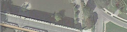
6 Current Conditions of the Springbank Dam and the Thames River With the dam not in operation, the river is changing, resulting in a greater diversity of habitat and species in the study area. Many of the floodplain areas along the river upstream of the dam have seen new growth of a mix of native and non-native plant species. The stretch of the river within the study area is home to 17 different Species at Risk (SAR). The Springbank Dam is not operating because of damage to the dam gates. The area of the river that was once a reservoir now flows freely. Access to the river for recreation has been reduced. The depth of water in the river now varies with rainfall and snowmelt.
7 Potential Species at Risk (SAR) and Species of Concern Additional SAR are present in the study area such as plants, birds and mammals and insects. The table below lists the species that are most likely to use the river for various aquatic functions. Status is given to species by both the federal and provincial governments. Common Name ederal Species At Risk Act Status Provincial Endangered Species Act Status Turtles Eastern Spiny Softshell END END Northern Map Turtle SC SC Snapping Turtle SC SC Snakes Eastern Milksnake SC NAR Queensnake END END Eastern Hog-nosed THR THR Snake ish Silver Shiner THR THR Black Redhorse THR THR Northern Brook Lamprey SC SC Pugnose Minnow THR THR Spotted Sucker SC SC Mussels Wavy-rayed Lampmussel SC THR Salamander Mussel END END Rainbow Mussel SC THR Rayed Bean END END Round Pigtoe END END Mapleleaf Mussel SC THR END - Endangered: Species facing imminent extirpation or extinction. THR - Threatened: Species which are likely to become endangered if nothing is done to reverse the factors leading to their extirpation or extinction. SC - Special Concern: A wildlife species that may become a threatened or an endangered species because of a combination of biological characteristics and identified threats. NAR - Not at Risk: A wildlife species that has been evaluated and found to be not at risk of extinction given the current circumstances.
8 Thames River Vision Thames Valley Corridor Plan The Thames Valley Corridor is considered London s most important natural, cultural, recreational, and aesthetic resource. Promote and enhance the orks of the Thames River and the Thames Valley Corridor as an important natural, cultural, recreational, and aesthetic resource within our city. The London Plan Recognize and build upon the important linkages between economy and environment. Protect and enhance our Thames Valley corridor and its ecosystem. Back to the River Back to the River was an initiative to revitalize the Thames River through an international design competition. The winning design Ribbon of the Thames was submitted by Civitas, a US landscape architecture firm, and Stantec, a local consultant.
9 Alternatives that were Considered for the Springbank Dam in Stage 1 Alternative 1: Do Nothing The dam will be maintained in its current condition, with no upgrades or repairs. Alternative 2: ree lowing River Remove all or part of the dam so that it can no longer provide a water retention function. May include Alternatives for repurposing, such as using structure for viewing platform or walkway. Alternative 3: Reinstate the Dam Repair or reconstruct dam so that it can provide a water retention function. Should operate at a similar capacity as it did previously. May include alternatives for repurposing, such as using structure for viewing platform or walkway.
10 Outcome of Stage 1 Stage 1 of the One River EA focused on making a decision on the future of the Springbank Dam. It was complete in January 2018 with the selection of ree lowing River Alternative for the Springbank Dam. The preferred alternative was selected through a rigorous evaluation of each of the alternatives on the basis of their net social/cultural, environmental, technical and economic impacts.

11 Purpose of Stage 2 The Purpose of Stage 2 is to develop and evaluate alternative river management strategies. Stage 2 will consist of 3 components: River Management Plan Dam Decommissioning ork of the Thames The preferred Alternative for each component will be chosen based on Environmental, Social & Cultural, Technical, and Cost criteria.
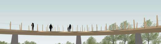
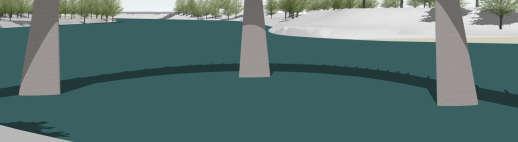
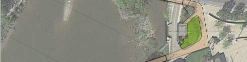
12 Stage 2 River Management Plan Alternatives Recreational Bridge Construction Becher Bridge Dyke Projects Concepts for the North Thames Scour Pool Concepts for Riverview Evergreen and Coves Dyke Linear Infrastructure Renewal Projects Replace Labatt Sanitary Siphon Increased Water Depth Natural Enhancement eatures Construction of weir or Riffle pools Thames Valley Corridor Plan Recommendations Develop Natural Heritage, Stewardship and Protection Projects Assess and identify canoe and kayak launch locations Make recommendations with respect to existing lookout locations


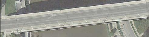
13 Stage 2 River Management Plan Alternatives Map
14 Stage 2 Springbank Dam Decommissioning Alternatives Alternative 1: Do Nothing The dam will be maintained in its current condition, with no upgrades or repairs. Alternative 2: Partial Dam Removal Remove and/or salvage components of the dam such as hydraulics, electronics and gates. Stabilize the dam structure and surrounding works for safety, and perform erosion repair. May include Alternatives for repurposing, such as using structure for viewing platform or walkway. Alternative 3: ull Dam Removal ully remove dam components and structure including gates, piers and surrounding erosion control works. ully restore impacted river bank areas.


15 Stage 2 Springbank Dam Decommissioning Alternatives Alternative 1: Do Nothing Alternative 2: Partial Dam Removal Alternative 3: ull Dam Removal


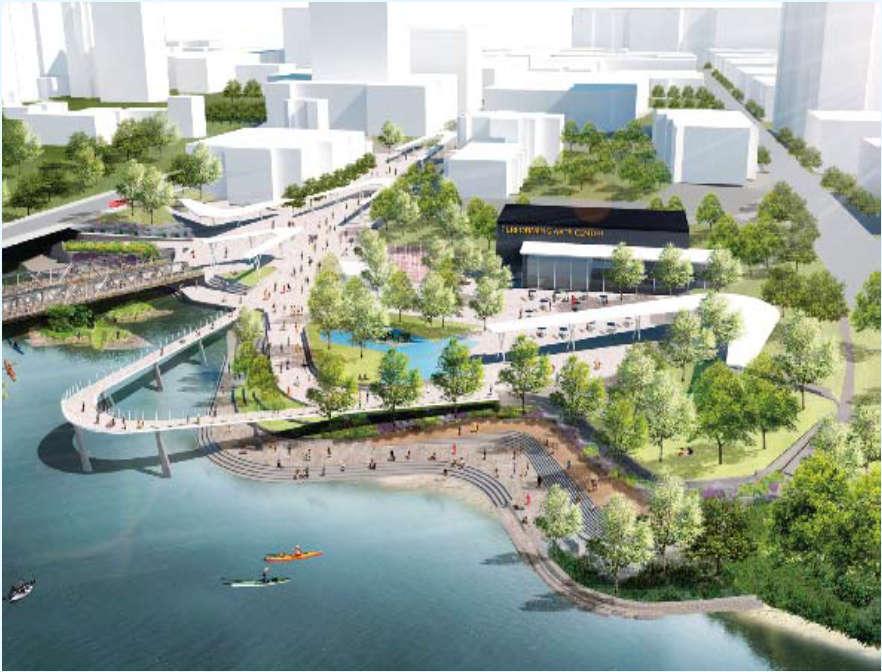
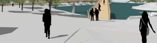
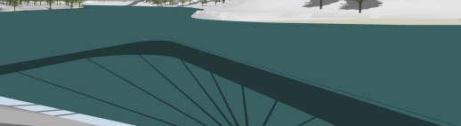
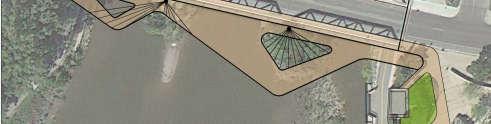
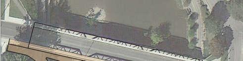
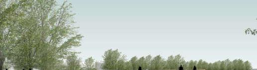
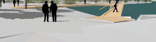
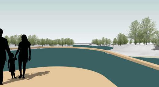
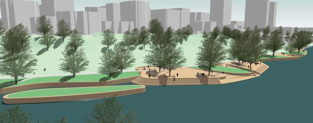
16 orks of the Thames Design Alternatives


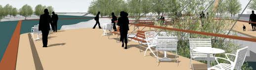
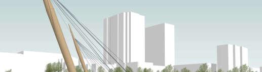
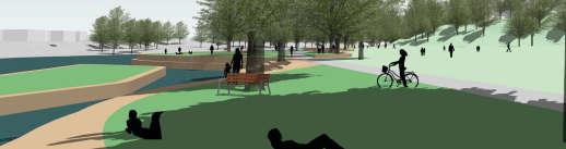
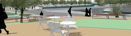
17 Design Principles 1. Destination: Provide a celebrated public realm connecting Londoners to the Thames from downtown and surrounding neighborhoods across the river. The Ribbon Overlook establishes a signature iconic element with striking views of the Thames and downtown. 2. Accessibility: Make park amenities accessible for everyone. This can be accomplished by constructing terraces with a sloping sidewalk that provides wheelchair access from Ivey Park to the performance terrace. 3. Durability: Quality materials and crafted details will be utilized to create a place that will endure many public events throughout the seasons. The orks must be able to withstand heavy pedestrian use on a daily basis. The design must also be resilient year-round and endure episodic flooding. 6. Utilize Existing Amenities: Protect existing splash pad and historic One Dundas. Provide connection to TVP and protect existing mature trees where possible. 7. Design as a Catalyst: The orks is the prime location for future investment for London. Phase one improvements shall be designed with the flexibility to accommodate a range of development and programming opportunities in future phases. 8. easible: The final design must be realistic in terms of constructability and ability to obtain permits and approvals. 4. Restore Nature: Improve habitats for species-at-risk that may be present and provide ecological enhancements to encourage habitat biodiversity. 5. Cultural Heritage: Provide a setting for irst Nations to be respected and celebrated.


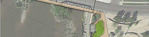
18 aram t rs and Constra nts Th orks us um London arr s ark rbank A rotect ex st ng sewer outfall B C rotect ex st ng sewer e rotect ex st ng water ma n I Remove barr ers and enhance connect v ty between museum, Dundas, Kens ngton Br dge, and the orks H J L m t m rovements to bottom of ex st ng r verbank Ma nta n ex st ng T al gnment A D rotect ex st ng s lash ad H A B C E D E rotect ex st ng One Dundas Ident fy s ec men trees and rotect when oss ble G Remove nvas ve vegat on and o en u v ews I I H J B A G G H L m t m rovements to bottom of ex st ng r verbank I G


19 bbon O rlook lt rnat 1 (Or g nal D s gn Com t t on


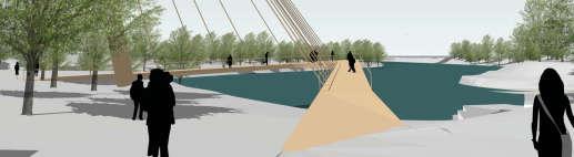
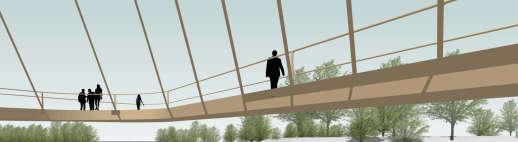
20 bbon O rlook lt rnat 2


21 bbon O rlook lt rnat 3


22 bbon O rlook lt rnat


23 T rrac s Urban lt rnat A U er Terrace B C D Am h theater seat ng erformance Terrace Lower Terrace E Access ble slo ng s dewalk G rst Nat ons Treaty S gn ng Monument lay area A G D C B E


24 T rrac s g tat d lt rnat A U er Terrace B C D Am h theater seat ng erformance Terrace Lower Terrace E Access ble slo ng s dewalk G rst Nat ons Treaty S gn ng Monument lay area A G D C B E


25 arr s ark Urban Edg lt rnat A B rogrammable Hab tat sland la a B C Seat ng terrace C A A C C A C


26 arr s ark g tat d Edg lt rnat A Lawn ods B C Hab tat sland Seat ng terrace B C A A B C B C


27 us um London Dundas Conn ct on A Remove wall and add ste s B Relocate crosswalk C D Re al gn dr ve Terraces ark entry E Museum events la a E D C B A
28 Relative Cost of Design Alternatives for Dam Decommissioning and orks of the Thames Dam Decommissioning Alternative 1: Do Nothing Alternative 2: Partial Dam Removal ($1M-$5M)* Alternative 3: ull Dam Removal ($10M-$20M)* *Costs are initial estimates only. More detailed costs will be estimated as concepts are further developed. orks of the Thames: How will this work be funded? The Ribbon of the Thames conceptual plan was endorse by City Council in January 2016 but the related projects are not currently included in the City of London s multi-year budget. In order to proceed, any orks of the Thames projects work would need to be approved by Council and included in future multi-year budget. The City will work with the London Community foundation in an effort to canvas for prospective provide donors.
29 Stage 2 Consultation and Engagement Notice of Stage 2 A formal notice to announce Stage 2 of the One River EA process and the Public Information Center was published in The Londoner on May 3 and May 10. Surveys Information is being collected via survey about London residents ideas and wishes for the future of the river. Webpage A project webpage was created on the getinvolved.london.ca website. The webpage is the central online resource for project information. Stakeholder Meetings The project team will continue to meet with local stakeholders including community associations and recreational groups to better understand their vision for the river moving forward. Media Local news media coverage raised awareness of the One River Master Plan EA in Stage 1 and this will continue into Stage 2. Public Information Centre This event is being held this evening to offer information to the public and give the public an opportunity to provide feedback on their opinions of the three Stage 2 components. irst Nations Engagement The project team has facilitated engagement with irst Nations on study process and objectives for the three components of Stage 2.
30 Stage 2 Evaluation Criteria The preferred Alternatives for the Springbank Dam Decommissioning, the Back to the River design and the River Management Strategy will be selected based on the following sets of Environmental, Social and Cultural, and Economic and Technical criteria. Natural Environment Category & Criterion Description Measure/Indicator Water Quality The potential of the option to maintain or improve water quality. Potential change in water quality compared to the existing conditions for total suspended solids (TSS) and total phosphorous (TP). Geomorphology The potential of the option to result in a stable river system (i.e. stable streambanks and stream bottom conditions) to optimize sediment transport to support a healthy aquatic environment. Potential change in the extent and risk of streambank erosion and stream bottom scour compared to the existing conditions. Species at Risk The potential of the option to protect and enhance the habitat of sensitive species and species at risk (both aquatic and terrestrial). Potential change in the extent and quality of significant habitats for sensitive species at risk compared to the existing conditions. Terrestrial Habitat The potential for the option to maintain or enhance terrestrial and riparian habitat for both plants and animals. Potential change in the terrestrial habitat function and production capacity compared to existing conditions. Aquatic Habitat The potential for the option to maintain or enhance habitat for aquatic dependent species. Potential change in the aquatic habitat function and production capacity compared to existing conditions. Groundwater and Surface Water Interactions The potential of the option to protect or improve groundwater and surface water interactions in order to maintain or improve water quality and quantity. Potential changes in groundwater and surface water interactions compared to existing conditions.
31 Social/Cultural Evaluation Criteria Category & Criterion Description Measure/Indicator Archeological/Cultural Heritage The potential of the option to protect archeological and cultural/heritage resources. Potential of the construction and related changes to the river regime to impact archeological and cultural heritage resources. Public Health & Safety Boating Recreation The potential of the option to minimize risk or liability to community health and safety. The potential of the option to provide or enhance boating recreational activities. Potential change in risk or liability to community health and safety from existing conditions. Potential change in boating (canoeing, kayaking, etc.) recreational activities and areas from existing conditions. ishing Recreation The potential of the option to provide or enhance fishing recreational activities. Potential change in fishing recreational activities and areas from existing conditions. Land Based Recreation Shoreline Accessibility The potential of the option to provide or enhance land based recreational activities such as walking, biking and bird watching. The potential of the option to enhance public accessibility to the river. Potential change in land based recreational activities and areas from existing conditions. Potential change in sites and areas for shoreline access from existing conditions. Aesthetics The potential of the option to maintain or enhance the visual character of the river corridor. Potential change in the visual character of the river corridor from existing conditions. irst Nations Interest The potential of the option to address irst Nations and Métis interests. Ability to address irst Nations and Métis interests. Urban Revitalization Integration with "The London Plan" The potential of the option to encourage investing in London's downtown as the heart of the City to support urban regeneration and revitalization, as well as provide a signature attraction. The potential of the option to facilitate and integrate with planned and proposed land use change in downtown London, the potential to support linkages to parks and open space system, the potential to enhance or impact existing or proposed pedestrian and cycling linkages, and the potential change in vistas. Potential to encourage investing in London's downtown. Potential to improve the experience and accessibility of the public to enjoy a wide range of recreational activities associated with The orks.
32 Technical and Economic Evaluation Criteria Category & Criterion Description Measure/Indicator lood Hazard The ability of the option to mitigate flood hazards. Potential change in risk of flood and erosion damage to public infrastructure and private property. Carbon ootprint The ability of the option to minimize carbon footprint. Potential change in carbon footprint from existing conditions, including the change in energy requirements during construction and operations. Constructability The ease of the option to be constructed and implemented on a technical basis. Ease of constructing the option, considering land requirements for works and staging areas, construction equipment, and timeframe for construction. Approvability The ease of the option to obtain required permits and approvals from regulating agencies (e.g. UTRCA, MNR, MOECC, DO). Ease of obtaining approvals and permits, including timeframe for receiving approval. Operations & Maintenance The ease of the option to be operated and maintained. Degree of change in operations and maintenance requirements from existing conditions. Compatibility with existing and planned infrastructure projects The compatibility of the option with existing and planned public infrastructure projects. Ability of an option to be integrated with or complement existing and planned infrastructure projects. Capital Cost Relative capital costs. Capital costs of an option relative to other options.
33 Agency Considerations The project team has consulted with relevant regulatory agencies including: Conservation Authorities (UTRCA, LTVCA), isheries and Oceans Canada (DO), Ministry of Natural Resources and orestry (MNR), Ministry of Environment and Climate Change (MOECC) throughout the project on potential impacts permitting requirements. The focus of the Stage 2 discussions will be on the environmental impacts of the River Management Strategy, including the Back to the River Alternatives and the Springbank Dam decommissioning Alternatives to enable the agencies to provide guidance to the project team on the evaluation of Alternatives.

34 Next Steps urther environmental field studies will be completed through spring and summer 2018 to provide information on potential impacts and to support the evaluation criteria. A second PIC in fall 2018 will present the refined alternatives and the preferred alternatives to receive further comment and feedback. The One River EA final report will be taken to City Council for approval in late Components of the River Management Strategy that require further EA work will put forward, while those addressed as Schedule B EA alternatives can move to next stages of design and construction.
35 Give us your opinion on the uture of the Thames River! eedback on the three EA components of the EA is an important part of the decision making process. Your opinion is welcome and appreciated! Please fill out the survey provided. We have copies here or you can fill out online at:
One River Environmental Assessment. Welcome!
 One River Environmental Assessment Welcome! One River Environmental Assessment Welcome to the One River Environmental Assessment Public Information Centre. Please explore each presentation area to learn
ONE RIVER MASTER PLAN ENVIRONMENTAL ASSESSMENT
 ONE RIVER MASTER PLAN ENVIRONMENTAL ASSESSMENT TERMS OF REFERENCE 1. ONE RIVER PROJECT OVERVIEW At its meeting on May 17, 2016, Council considered a staff report regarding the One River Master Plan Environmental
Vaughan Metropolitan Centre (VMC) Black Creek Renewal CLASS ENVIRONMENTAL ASSESSMENT
 Black Creek Renewal CLASS ENVIRONMENTAL ASSESSMENT") PUBLIC INFORMATION CENTRE Vaughan Metropolitan Centre (VMC) Black Creek Renewal Wednesday, May 10, 2017 6:00 p.m. to 8:00 p.m. Add photo Project Management, Environmental Assessment, Stormwater Management
PUBLIC INFORMATION CENTRE Vaughan Metropolitan Centre (VMC) Black Creek Renewal Wednesday, May 10, 2017 6:00 p.m. to 8:00 p.m. Add photo Project Management, Environmental Assessment, Stormwater Management
10.0 Open Space and Public Realm
 10.0 Open Space and Public Realm 10.0 Open Space and Public Realm The Public Open Space System is comprised of: outdoor spaces available for public use that are either publicly owned (e.g., parks and
Scarborough Waterfront Project
 Scarborough Waterfront Project Public Information Centre #1 Environmental Assessment Terms of Reference September 10, 2014 Agenda Open House Presentation 7:00 to 7:30 pm Presentation 7:30 to 8:15 pm History
West London Dyke, April 1947 Flood. Forks of the Thames, July 2000 Flood. Source: UTRCA
 This Public Information Centre is the 1 st of 2. Its purpose is to inform the public and to receive input with regards to the West London Dyke Master Repair Plan. The following panels describe the history,
Slope Stability Management Framework
 Slope Stability Management Framework For the assessment, evaluation, prioritization and mitigation of slope stability concerns. 2013/06/19 The Slope Stability Management Framework provides guidance to
Call for Artists for: Design and Construction of Environmental Art Activation Story Mill Community Park, Bozeman, MT
 Call for Artists for: Design and Construction of Environmental Art Activation Story Mill Community Park, Bozeman, MT Seeking artists to design, fabricate and install art elements in the nature sanctuary
Don Narrows Workshop DRAFT MEETING REPORT Saturday, May 24, 2008 South Regent Park Recreation Centre
 Don Narrows Workshop DRAFT MEETING REPORT Saturday, May 24, 2008 South Regent Park Recreation Centre Introduction to the Workshop & this Report On Saturday, May 24, 2008 Toronto and Region Conservation
Cherry Beach Shoreline Protection Infrastructure Conceptual Design and Class EA
 Welcome Cherry Beach Shoreline Protection Infrastructure Conceptual Design and Class EA May 3, 2012 Study Area Cherry Beach neighbourhood is located in lower Stoney Creek on Lake Ontario, east of Millen
2011 ASLA Design Awards. Westside Creeks Restoration Plan Merit Award AECOM, Fort Collins. Planning & Urban Design
 2011 ASLA Design Awards Westside Creeks Restoration Plan Merit Award AECOM, Fort Collins Planning & Urban Design Project Fact Sheet Category of Entry: Rotating Specialty Award: 2011 2011 ASLA Colorado
The purpose of tonight s PIC is to:
 The purpose of tonight s PIC is to: Provide an overview of the work completed to date and a summary of the Class EA process being followed; Provide a summary of public input received so far, including
Mississauga Waterfront. Parks Strategy - Draft
 Potential configuration for river s edge seating. Boating on Credit River: A regatta Boating on Credit River: Active enjoyment 5.2 Port Credit Memorial Park West Priority Park 5.2.1 Site Opportunities
Rapid Transit Implementation Working Group September 14, 2017
 Rapid Transit Implementation Working Group September 14, 2017 BACKGROUND Council approved the Rapid Transit Master Plan and Updated Business Case on July 25, 2017. Approval of the RTMP confirmed the BRT
City of Iowa City Department of Neighborhood and Development Services Department of Parks and Recreation Department of Public Works City Manager s
 RFP Pre-submittal meeting December 18, 2015 City of Iowa City Department of Neighborhood and Development Services Department of Parks and Recreation Department of Public Works City Manager s Office Background
Rapid Transit Implementation Working Group
 Rapid Transit Implementation Working Group October 12, 2017 1 Agenda 1. Consultation Update 2. Technical Work Update 3. LTC Rapid Transit Integration 4. Next Steps 2 Consultation Update 3 Consultation
Arkansas River Corridor
 Planning for Access Welcome to the Access Project. This project is a recreational planning effort in response to an interest by regional communities along the Arkansas River corridor. The project plan
ADOPTED CAPITAL IMPROVEMENT PROGRAM BUDGET ARROYO PROJECTS
 ADOPTED CAPITAL IMPROVEMENT PROGRAM BUDGET ARROYO PROJECTS HAHAMONGNA FY 212-216 Capital Improvement Program Priority Description Total Estimated Costs Appropriated Through FY 211 Adopted FY 212 FY 213
Please read the entire document
 projects impacting the waterfront revitalization area. The waterfront revitalization area of the town will have to subareas to the west and east of the village. Page 6 of 6 Wayfinding master plan create
DISCUSSION TOPIC: ST JOHNS RIVER & ITS TRIBUTARIES (BPII) 2030 COMPREHENSIVE PLAN POLICES AND REGULATORY FRAMEWORK
 2030 COMPREHENSIVE PLAN POLICES AND REGULATORY FRAMEWORK") DISCUSSION TOPIC: ST JOHNS RIVER & ITS TRIBUTARIES (BPII) 2030 COMPREHENSIVE PLAN POLICES AND REGULATORY FRAMEWORK St. John s River & Its Tributaries Issue Summary: The St. Johns River is an important
DISCUSSION TOPIC: ST JOHNS RIVER & ITS TRIBUTARIES (BPII) 2030 COMPREHENSIVE PLAN POLICES AND REGULATORY FRAMEWORK St. John s River & Its Tributaries Issue Summary: The St. Johns River is an important
An Ambitious Plan: Transforming the blighted South Platte River and surrounding environment into Denver s greatest natural resource.
 CONNECTING THE PEOPLE TO THEIR RIVER SOUTH PLATTE RIVER VISION IMPLEMENTATION PROGRAM: GRANT-FRONTIER PARK TO OVERLAND POND PARK REACH The South Platte River Vision Implementation Program (River Vision)
Edgeley Pond + Park Public Meeting
 Edgeley Pond + Park Public Meeting February 21, 2017 Purpose of the meeting This Public Meeting is an opportunity for you to review the project background, process and provide input. City of Vaughan staff
UNIVERSITY TOWN NEIGHBOURHOODS 5.2 ECO-CORRIDOR MELBOURNE CAMPUS MASTER PLAN 2014
 5.2 ECO-CORRIDOR 37 ECO-CORRIDOR EXISTING CONDITIONS & VISION NEIGHBOURHOOD VISION Investment in the Eco-corridor Neighbourhood will signify the University s commitment to supporting local ecology and
ARROYO PROJECTS ADOPTED CAPITAL IMPROVEMENT PROGRAM BUDGET
 A RROYO P ROJECTS ADOPTED CAPITAL IMPROVEMENT PROGRAM BUDGET FISCAL YEARS 214-218 HAHAMONGNA Priority Description 1 Hahamongna Watershed Park - Implement Master Plan 211,6 211,6 (77565) 2 Hahamongna -
edmonton.ca/ribbonofgreen #ribbonofgreen
 WHAT IS THE RIBBON OF GREEN? The Ribbon of Green is Edmonton s entire river valley and ravine system. The Ribbon of Green (2018) Project will provide strategic guidance for the southwest and northeast
Case Study Presentation of the Downtown Brampton Flood Protection Class EA
 Case Study Presentation of the Downtown Brampton Flood Protection Class EA Presented by: Kenneth M. Dion, Project Director Port Lands Integration, Waterfront Toronto (formerly Senior Manager, TRCA) At:
Shift Rapid Transit Public Participation Meeting May 3, 2017
 Shift Rapid Transit Public Participation Meeting May 3, 2017 Shift Rapid Transit Initiative Largest infrastructure project in the city s history. Rapid Transit initiative will transform London s public
ARISE: The Rock Renaissance Area Redevelopment & Implementation Strategy
 2014 Professional Awards 1 ARISE: The Rock Renaissance Area Redevelopment & Implementation Strategy Janesville, WI Completed December 2014 Analysis & Planning Purpose of Project 2 The purpose of the Rock
A Joined-up Regional Landscape: A Roadmap to connect the parts
 Breaking the Barriers: Engineering Solutions to Ecological Problems A Joined-up Regional Landscape: A Roadmap to connect the parts Associate Professor Darryl Low Choy Urban Research Program Outline Nature
Central Lake Ontario Conservation Conservation Lands Master Plan
 Conservation Lands Master Plan Top 13 Frequently Asked Questions 1. What are conservation lands? Where are these conservation lands located in the Central Lake Ontario Conservation watershed? Conservation
April 11, 2016 Park Board Chair and Commissioners General Manager Vancouver Board of Parks and Recreation New Brighton Salt Marsh - Preferred Concept
 TO: FROM: SUBJECT: April 11, 2016 Park Board Chair and Commissioners General Manager Vancouver Board of Parks and Recreation New Brighton Salt Marsh - Preferred Concept RECOMMENDATION A. THAT the Vancouver
PEOPLE, WATER, AND WILDLIFE: BLUE PRINCIPLES FOR RIVER DESIGN
 PEOPLE, WATER, AND WILDLIFE: BLUE PRINCIPLES FOR RIVER DESIGN Category One: People Protecting and Enhancing the Quality of Life Role of the Chicago River People and the River For many, the connection between
Wetland Design Manual. A1: Vision, core outcomes and aspirational outcomes
 Wetland Design Manual A1: Vision, core outcomes and aspirational outcomes Table of contents Introduction 5 Vision 6 Core outcomes 7 Effective pollutant removal and flow management... 7 Community safety...
SAN RAFAEL GENERAL PLAN 2040 INTRODUCTION AND OVERVIEW
 SAN RAFAEL GENERAL PLAN 2040 INTRODUCTION AND OVERVIEW Steering Committee Presentation February 14, 2018 Purpose of General Plan Guide land use and development decisions Coordinate transportation, infrastructure,
Visioning Statement and Guiding Principles
 Visioning Statement and Guiding Principles Planning for the Future The General Plan The General Plan represents Woodland's shared vision of the future and defines a path to lead the community toward its
Better Cycling. The City will update the cycling master plan (London ON Bikes) based on the approved BRT network.
 based on the approved BRT network.") Better Cycling Dedicated bike facilities will be constructed along BRT corridors where space is available. Nearby bike routes will also be upgraded to ensure a complete network is available for cyclists.
Better Cycling Dedicated bike facilities will be constructed along BRT corridors where space is available. Nearby bike routes will also be upgraded to ensure a complete network is available for cyclists.
INTRODUCING THE BALTIMORE CITY GREEN NETWORK VISION PLAN
 INTRODUCING THE BALTIMORE CITY GREEN NETWORK VISION PLAN GOALS OF THE GREEN NETWORK PLAN Protect and enhance the unique ecological resources of our city Support economic growth and sustainable redevelopment
1 Introduction. Chapter. In this chapter:
 Chapter 1 Introduction In this chapter: 1.1 A Snapshot of the Region 1.2 Towards a Sustainable Region 1.3 The Provincial Context 1.4 Purpose and Organization The Regional Municipality of York Official
The Recreational Heart of Cannington - MacLeod & Claire Hardy Parks
 The Site Claire Hardy Park and MacLeod Park are both located within the community of Cannington on opposing shorelines of the Beaver River and are accessible to each other by a footbridge spanning the
Blackfriars Bridge Municipal Class Environmental Assessment. Public Information Centre #1 November 19 th, 2014
 Blackfriars Bridge Municipal Class Environmental Assessment Public Information Centre #1 November 19 th, 2014 Why are you here tonight? To determine the future requirements of the river crossing at Blackfriars
Ashbridges Bay Erosion and Sediment Control Project
 Ashbridges Bay Erosion and Sediment Control Project Project Brief Overview Toronto and Region Conservation Authority, in partnership with the City of Toronto, intends to carry out remedial erosion control
Public Open House. Overview of the Downtown Plan Official Plan Amendment April 23, 2018
 Public Open House Overview of the Downtown Plan Official Plan Amendment April 23, 2018 1 A 25-Year Plan for Downtown To ensure growth contributes positively to Toronto s Downtown as a great place to live,
Preliminary Plan Framework: Vision and Goals
 Preliminary Plan Framework: Vision and Goals Draft: May 2015 Introduction Since the Town of Milliken s comprehensive plan was last updated in 2010, the community was heavily impacted by the 2013 flood,
WELCOME! 8 8:30 6: TH STREET IMPROVEMENTS. Open House. Presentation & Q&A
 WELCOME! 168 TH STREET IMPROVEMENTS 6:30 Open House 7 8 Presentation & Q&A 8 8:30 Open House WELCOME Todd Pfitzer City of Omaha Engineer Bob Stubbe City of Omaha Public Works Director Jon Meyer Project
GEOMETRIC IMPROVEMENTS AND WATERMAIN LOOPING MUNICIPAL CLASS ENVIRONMENTAL ASSESSMENT
 GEOMETRIC IMPROVEMENTS AND WATERMAIN LOOPING MUNICIPAL CLASS ENVIRONMENTAL ASSESSMENT Veterans Way (previously Powerline Road) and Klondike Park Road Wasaga Beach Welcome Please sign in Take a comment
Taché Promenade Tuesday, October 17, 2017
 Welcome to the Public Information Session for the City of Winnipeg s Taché Promenade Tuesday, October 17, 2017 We want to hear from you. Please participate today by: Viewing the recommended design and
University of Saskatchewan CAMPUS MASTER PLAN. Senate Meeting Preliminary Presentation. April 21, 2018 DIALOG ECS DA WATT
 University of Saskatchewan CAMPUS MASTER PLAN Senate Meeting Preliminary Presentation April 21, 2018 DIALOG ECS DA WATT project process presentation agenda Stakeholder Engagement Project Control phase1
APPENDIX L3. Table of Contents. SWP EA Information Sheets
 E N V I R O N M E N T A L A S S E S S M E N T APPENDIX L3 SWP EA Information Sheets Table of Contents EA Info Sheet 1... L3-1 EA Info Sheet 2... L3-3 EA Info Sheet 3... L3-5 EA Info Sheet 4... L3-7 SCARBOROUGH
Arlington, Virginia is a worldclass
 EXECUTIVE S U M M A RY Arlington maintains a rich variety of stable neighborhoods, quality schools and enlightened land use policies, and received the Environmental Protection Agency s highest award for
APPENDIX K WINDSOR OFFICIAL PLAN
 CEAA ENVIRONMENTAL ENVIRONMENTAL IMPACT ASSESSMENT AMBASSADOR BRIDGE ENHANCEMENT PROJECT Replacement Span and Plaza Expansion APPENDIX K WINDSOR OFFICIAL PLAN Avalon Consulting Professionals of Ontario,
Urban runoff in my neighborhood (Capitol Hill) is heavy with trash and other debris.
 is heavy with trash and other debris.") South Platte River Meeting Comments & s #1 I am a huge fan of river areas and would love the Platte and surrounding waterways to improve to allow habitat for wildlife and recreation opportunities for citizens.
South Platte River Meeting Comments & s #1 I am a huge fan of river areas and would love the Platte and surrounding waterways to improve to allow habitat for wildlife and recreation opportunities for citizens.
WARM SPRINGS PARK MASTER PLAN
 TABLE OF CONTENTS page 1.0 Introduction and Overview 1 2.0 Information Gathering 2 3.0 Conceptual Alternative Development 8 4.0 Master Plan Development 14 5.0 Construction Cost Estimates 19 LIST OF FIGURES
Improving Communities Through the Arroyo Seco Sustainability Campaign and Watershed Assessment
 Improving Communities Through the Arroyo Seco Sustainability Campaign and Watershed Assessment Arroyo Seco Headwaters in the San Gabriel Mountains Major tributary to the Los Angeles River 44 square mile
Town of Peru Comprehensive Plan Executive Summary
 Town of Peru Comprehensive Plan Executive Communities that plan grow by choice, not by chance. A plan makes growth thoughtful, understandable, and predictable. A plan shows that a community is managing
Presentation to Parks and Open Space Advisory. Committee September 22, 2016
 Flood Planning & Preliminary Design Services for South St. Vrain Creek Restoration at Hall Ranch Presentation to Parks and Open Space Advisory Prepared for: Boulder County, Colorado Committee September
{Best Practices. Summary of Tools, Strategies and Best Practices from 11 Michigan Case Study Communities
 Case Studies Michigan Coastal Community Working Waterfronts { Summary of Tools, Strategies and from 11 Michigan Case Study Communities Table of Contents Zoning...2 Community and Stakeholder Collaboration
WILLIAM STREET STORM SEWER OUTFALL. PUBLIC INFORMATION CENTRE March 23, 2017
 WILLIAM STREET STORM SEWER OUTFALL Municipal Class Environmental Assessment PUBLIC INFORMATION CENTRE March 23, 2017 ACCESSIBILITY Under the Accessibility Standards 2015 for Customer Service Regulation
TOWN COUNCIL / PLANNING COMMISSION
 Workshop #3 TOWN COUNCIL / PLANNING COMMISSION January 20, 2011 Consultant Team In Attendance Tonight BMS Design Group Nevada City and San Francisco Michael Smiley, AICP, ASLA Partner-in-Charge Nancy L.
St. Clair Avenue West Area Transportation Master Plan
 1 (Between Keele Street and Old Weston Road) Public Information Centre 1 December 2, 2015 2 Welcome Welcome to the first Public Information Centre for the St. Clair Avenue West Area. The panels will present
Animating the Rideau Canal December 2013
 Executive Summary Animating the Rideau Canal December 2013 Why study the Rideau Canal? The Rideau Canal has been an important part of Ottawa throughout its history, and has shaped and been shaped by the
An Introduction to the Far North Land Use Strategy
 An Introduction to the Far North Land Use Strategy December, 2013 Ministry of Natural Resources Table of Contents PREFACE... 3 About the Far North... 3 Evolution of Land Use Planning in the Far North...
Your town s subdivision or land use ordinance standards should reference the following street standards, for example:
 Your town s subdivision or land use ordinance standards should reference the following street standards, for example: Streets shall be designed to move traffic safely and in a way that minimizes environmental
Building Great Neighbourhoods. Strathcona
 Building Great Neighbourhoods Strathcona March 21, 2018 Becky Redford Project Manager, Planning & Design Building Great Neighbourhoods Integrated Infrastructure Services Welcome and Purpose To provide
Reconnecting to a Forgotten River St. Cloud MN. Aaron Hanson Design Design Thesis LA 572, Thesis, Spring 2012
 Reconnecting to a Forgotten River St. Cloud MN Aaron Hanson Design Design Thesis LA 572, Thesis, Spring 2012 site context 2.5 Miles Sartell St. Cloud to Fargo 170 Miles (2 hrs 45 mins) Hwy 10 infrastructure
2011 ASLA Design Awards. Coyote Gulch Honor Award and Land Stewardship Designation Valerian LLC. Environmental Restoration and Reclamation
 2011 ASLA Design Awards Honor Award and Land Stewardship Designation Valerian LLC Environmental Restoration and Reclamation Project Name: Category : Project Location: 5 2011 Environmental Restoration and
Christchurch City Council Civic Offices 53 Hereford Street Christchurch. Submission on: The Draft Annual Plan 2014/15
 City Council Civic Offices 53 Hereford Street Submission on: The Draft Annual Plan 2014/15 Response by: Avon-Ōtākaro Network 9 Stable Way Belfast The Avon-Ōtākaro Network [AvON], is a network of individuals
Baby Point Wastewater Pumping Station Forcemain Class Environmental Assessment Study
 Baby Point Wastewater Pumping Station Forcemain Class Environmental Assessment Study Public Drop-in Event 1 Thursday, October 12, 2017 6:00 p.m. to 8:00 p.m. Humbercrest United Church Welcome Welcome to
Commissioners Road West Realignment Environmental Assessment
 City of London Commissioners Road West Realignment Environmental Assessment Public Information Centre No. 2 November 29, 2017 Welcome to the Public Information Centre This 2 nd Public Information Centre
Gibsons Foreshore & Seawalk Improvements
 Gibsons Foreshore & Seawalk Improvements Open House (5:00-7:00 pm) Town of Gibsons October 6, 2016 Town of Gibsons Foreshore & Seawalk Improvements 1 Session 3: Open House (Charrette Participants, Designers,
Public Information Meeting
 Lavon Lake Master Plan Revision Public Information Meeting March 10, 2015 Presented By Michael Kinard Lake Manager U.S. Army Corps of Engineers Fort Worth District US Army Corps of Engineers Purpose of
3-2 Environmental Systems
 3-2 Environmental Systems 3.0 ENVIRONMENTAL SYSTEMS CONTENTS 3.1 GREENWAY SYSTEM 3.1.1 General Policies 3.1.2 Natural Heritage Network 3.1.3 Natural Heritage Network Enhancement Lands 3.1.4 Rouge Watershed
Once Upon a Gravel Pit: Reconnecting Floodplain through Aggregate Extraction
 Once Upon a Gravel Pit: Reconnecting Floodplain through Aggregate Extraction 5 th International Conference on Natural Channel Systems September 26, 2016 1 The Story of Snyder s Flats Historical influences
CITY OF LONDON COVES ESA CONSERVATION MASTER PLAN COMMUNITY WORKSHOP #1
 CITY OF LONDON COVES ESA CONSERVATION MASTER PLAN COMMUNITY WORKSHOP #1 January 28 th 2014 Welcome! Purpose Reintroduce the Coves Conservation Master Plan (CMP) process; Provide an overview of Phase 1
At the Heart of the Great Lakes
 Walpole Island Heritage Centre May 2010 At the Heart of the Great Lakes Bkejwanong: Where the Waters Divide Bkejwanong s Ecosystems OVERVIEW Walpole Island supports a rich mosaic of natural areas including
GLEN ROAD PEDESTRIAN BRIDGE ENVIRONMENTAL ASSESSMENT STUDY PUBLIC INFORMATION CENTRE #2 OCTOBER 24, 2017
 GLEN ROAD PEDESTRIAN BRIDGE ENVIRONMENTAL ASSESSMENT STUDY PUBLIC INFORMATION CENTRE #2 OCTOBER 24, 2017 Glen Road Pedestrian Bridge Class Environmental Assessment 1 WELCOME! Welcome to the second Public
UTSC SECONDARY PLAN COMMUNITY OPEN HOUSE
 WELCOME TO THE UTSC SECONDARY PLAN COMMUNITY OPEN HOUSE 1 Welcome to the first Community Open House for the UTSC Secondary Plan. Hosted by the University of Toronto Scarborough (UTSC), the following panels
Big Picture Protected Areas Strategy Collaborating to Protect and Conserve Nature in Ontario s Carolinian Zone
 Big Picture Protected Areas Strategy Collaborating to Protect and Conserve Nature in Ontario s Carolinian Zone Jarmo Jalava Protected Areas Consultant Carolinian Canada Coalition National Workshop October
John M. Fleming Managing Director, Planning and City Planner. Old East Village Dundas Street Corridor Secondary Plan Draft Terms of Reference
 Report to Planning and Environment Committee To: From: Subject: Chair and Members Planning & Environment Committee John M. Fleming Managing Director, Planning and City Planner Old East Village Dundas Street
Blue/Green Infrastructure Study Accomack County, VA
 Blue/Green Infrastructure Study Accomack County, VA Draft Asset Maps March 8-9, 2010 Green Infrastructure Center, Inc. 2 Overview What is Green and Blue Infrastructure Project Timeline & Tasks Literature
This page intentionally blank.
 This page intentionally blank. Parks, Recreation, and Open Space Chapter Relationship to Vision Vision Parks, Recreation and Open Space Chapter Concepts County Government. County government that is accountable
Goleta Community Plan Update
 Goleta Community Plan Update Ecology, Biology, and Habitats GVPAC Meeting Agenda [Wednesday, December 17, 2008, 6:00PM] Pledge of Allegiance and Roll Call Public Comment Period Administrative December
Planning for Staten. Habitat Restoration and Green Infrastructure. Island s North Shore
 Habitat Restoration and Green Infrastructure Planning for Staten Island s North Shore Community Board 1 March 1, 2018 NYC Parks Forestry, Horticulture, and Natural Resources Funded by the NYS Department
A Vision For Miami s Twenty-first Century Parks And Public Spaces
 1 A Vision For Miami s Twenty-first Century Parks And Public Spaces Parks and Public Spaces in Miami 21 An urban renaissance is remaking the City of Miami as new residents, new visitors, and new investment
CHAPTER 8 ISSUES, CONCERNS, CONSTRAINTS AND OPPORTUNITIES
 CHAPTER 8 ISSUES, CONCERNS, CONSTRAINTS AND OPPORTUNITIES Introduction This River Conservation Plan was developed during a time of tremendous activity and effort in planning the transformation of the Delaware
Queensborough Eastern Neighbourhood Node. Community Open House
 Queensborough Eastern Community Open House The Vision The Queensborough Eastern will become the heart of eastern Queensborough. Through a sensitive mix of viable commercial and residential areas, the neighbourhood
Whitemarsh Comprehensive Plan Update: Housing & Land Use. Public Workshop #3: September 20, 2018
 Whitemarsh Comprehensive Plan Update: Housing & Land Use Public Workshop #3: September 20, 2018 Agenda Welcome Process Recap What We ve Heard The Plan Framework Review of Recommended Actions Land Use Housing
Toronto Complete Streets Guidelines
 Toronto Complete Streets Guidelines 108 110 7.1 Green Infrastructure Design Principles 112 7.2 Context-Sensitive Green Streets 114 7.3 Key Green Street Elements Green infrastructure refers to natural and
Lake O the Pines Master Plan Revision Public Information Meeting April 25 & 27, 2017
 Lake O the Pines Master Plan Revision Public Information Meeting April 25 & 27, 2017 Presented By Matthew Like, Lake Manager U.S. Army Corps of Engineers Fort Worth District US Army Corps of Engineers
City of Plattsburgh DRI: Downtown Streetscapes & Riverfront Access. Downtown Streetscape and Riverfront Access Design
 City of Plattsburgh DRI: Downtown Streetscapes & Riverfront Access Welcome Thank you for coming this evening. Agenda PART I - Project Context The Downtown Revitalization Program Our DRI Projects Other
A Vision for Walnut Creek
 A Vision for Walnut Creek Photo: City of Clive Walnut Creek Booklet 8 of 8 Greater Des Moines Water Trails and Greenways 1 Table of Contents Booklet 1: Water Trails Strategies and Policies Booklet 2: Beaver
Unique. Livable. Connected. Sustainable. Anticipate and Manage Change. Variety of Housing Choices. Enhanced Arterial Corridors
 Neighborhood Vision The Old Town Neighborhoods are Unique, Livable, Connected, and Sustainable. As mature, established neighborhoods, many of the ideas and opportunities expressed by stakeholders in support
implementation r expression in landscape
 6 ubc okanagan implementation campus plan r expression in landscape 68 6 implementation campus plan sections The Campus Plan supports the academic mission, values and commitments of the University by providing
Parks, Trails, and Open space Element
 Parks, Trails, and Open space Element Parks, Trails, and Open Space element Parks, Recreation, and Open Space are important components of the quality of life desired by the residents of Elk Grove. This
Parks, Trails, and Open Space Element
 P arks, Recreation, and Open Space are important components of the quality of life desired by the residents of Elk Grove. This Element of the General Plan addresses the City s goals, policies, and actions
E x E C U T I v E S U M M A R y / P L A N N I N G C O N T E x T 14 //
 14 // executive summary / planning context COMMUNITY GREENING PLAN PLANNING CONTEXT Capital Region Water has entered into a partial consent decree with the United States Department of Justice to address
Yarra Strategic Plan community engagement summary
 Yarra Strategic Plan community engagement summary Between May and August 2018 Melbourne Water undertook community engagement to build the content of the draft Yarra Strategic Plan. This engagement included
Lewisville Lake Master Plan Revision Public Information Meeting May 2 & 4, 2017
 Lewisville Lake Master Plan Revision Public Information Meeting May 2 & 4, 2017 Presented By Rob Jordan Lake Manager U.S. Army Corps of Engineers Fort Worth District US Army Corps of Engineers Purpose
Lake and Stream Restoration Project
 Pre-project Fact Sheet May 2012 Toledo Botanical Garden (TBG) is a 60 acre public garden visited by more than 120,000 people annually. It is located in Toledo, Ohio in the Ottawa River watershed within
Design Specifications & Requirements Manual
 11 PARKS & OPEN SPACES 11.1 DEFINITIONS... 1 11.1.1 Neighbourhood Parks... 1 11.1.2 District Parks... 1 11.1.3. Sport Parks... 1 11.1.4 Urban Parks... 1 11.1.5 Civic Spaces... 1 11.1.6 Open Space System...
Canyon Lake Master Plan Revision Public Information Meeting March 18, 2016
 Canyon Lake Master Plan Revision Public Information Meeting March 18, 2016 Marcus Schimank Canyon Lake Manager Capital Regional Office U.S. Army Corps of Engineers Fort Worth District US Army Corps of