Composing Agent and Landscape Models
|
|
|
- Percival Berry
- 5 years ago
- Views:
Transcription


1 Composing Agent and Landscape Models an Example from the Mediterranean Hessam Sarjoughian: School of Computing & Informatics C. Michael Barton: School of Human Evolution & Social Change Center for Social Dynamics & Complexity
 Creating a modeling laboratory for studying socioecological consequences of landuse")
2 Mediterranean Landscape Dynamics Project Supported by NSF ERE Biocomplexity in the Environment program (BCS ) Creating a modeling laboratory for studying socioecological consequences of landuse decisions


3 A Laboratory of the Past Transdisciplinary international research Developing a modeling laboratory for studying the long-term recursive dynamics of human landuse and landscape change Test hypotheses about social dynamics Evaluate social and ecological consequences of human decisions and action


4 A Laboratory of the Past Develop dynamic computer simulation models based on anthropological insights about social and ecological process past and present biophysical landscape processes Treat models as hypotheses and test against archaeological and paleoecological records Models must pass through known points of record that are scattered in both time and space.

5 Modeling Laboratory Agent-based simulation of human landuse: beginning of farming to beginning of urbanism Surface process models of ancient landscape and climate in GIS framework Dynamically compose disparate models so that change in one can affect state variables that serve as input to another


6 Modeling Terrain modeling: multi-yr. steps Laboratory Climate model Vegetation modeling: multi-yr. steps Potential landscape model 3 interlinked modeling environments Potential landscape model Reference landscape chronosequence Agropastoral socioecology model Paleobotanical data Veg. edaphic parameters Modern DEM Geological data Archeological data Agent Modeling Climate model Paleovegetation Paleoterrains (DEM s) Prehistoric settlement & landuse Settlement & landuse modeling Reference landscape chronoseq. Vegetation modeling: multi-yr. steps Terrain modeling: multi-yr. steps Initial state Initial state & validation at various stages Agropastoral socioecology model

7 Surface Process Dynamics USPED (Unit Stream Power Erosion/ Deposition) model for landscape change Iterated to simulate cumulative change Model parameters Landuse Topography Landcover Climate Soils

8 Surface Process Model
 ED = d(e p! q sx )/dx + d(e p!")
 for a given surface process across the cell E p (potential erodability) is modified a")
9 Surface Process Model Modeling environment built in GRASS Geographic Resource Analysis Support System Raster (cellular) landscape Implemented in bash scripts USPED (implemented in GRASS) ED = d(e p! q sx )/dx + d(e p! q sy )/dy ED is net erosion or deposition of sediment in any landscape cell q sx and q sy are the sediment transport capacity coefficients in x and y directions (a function of slope, aspect, and flow accumulation) for a given surface process across the cell E p (potential erodability) is modified a RUSLE value that includes rainfall intensity, land cover, and soil characteristics for that cell
10 Landuse Dynamics in GRASS Dynamic stochastic modeling Agropastoral catchments Iteratively grown outward from settlement Specify catchment size desired (e.g., ha/person in settlement) Anisotropic cost surface for walking across terrain Can limit by slope
11 Landuse Dynamics in GRASS Shifting agropastoralism (simple model) Specify catchment 3x size needed Randomly seed 30% as cultivated (or grazed) Iterate each year Simple revegetation/succession Allow formerly cultivated (or grazed) patches to return to scrub (after 1 yr) and woodland (after 2 year) when not cultivated (or grazed) Landuse and its history alters landcover.

 coupled")
12 Landuse Dynamics & ABM Multiagent simulation (DEVSJAVA) coupled with GIS (GRASS)

 cultivated")

13 Landuse Dynamics & ABM Multiagent simulation (DEVSJAVA) coupled with GIS (GRASS) cultivated wild fallow land use soil quality good poor land owners


14 Landuse Dynamics & ABM Household is basic unit Acquire land Potential productivity Distance from village Labor investment needed (e.g., clear land or simply cultivate Manage land Clearing land Cultivating crops Fallowing Harvest resources Land management activity Soil productivity Allow for stochasticity (e.g., land allocation, crop productivity, demography
")

15 Topography Terra ASTER DEMs (created from forward and backward band 3) Re-interpolated to 15m resolution for surface process modeling Study areas defined as watersheds
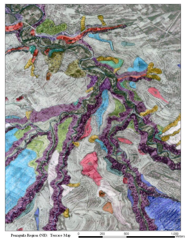


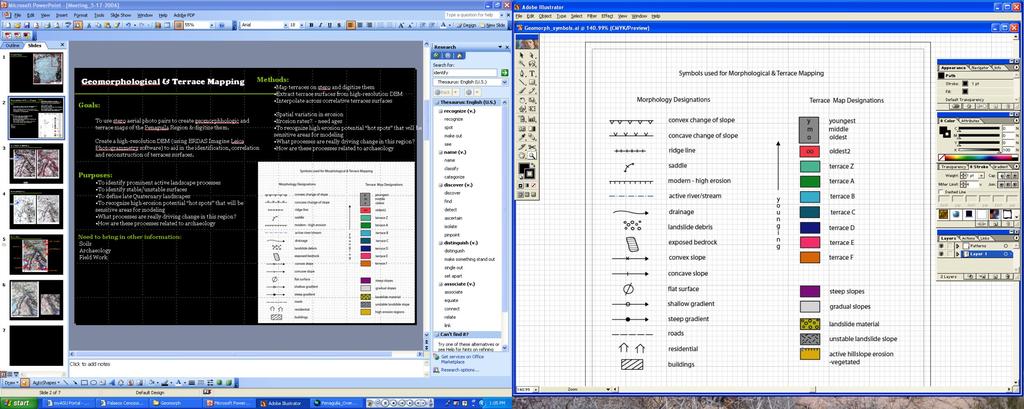


16 Topography Highresolution DEM created from stereo aerial photos Landform and geomorphic mapping Ground truthing in field residential flat to rolling surfaces active landslide active erosion hollow active drainage steep slopes terraces
 equivalent aged surface remnants using spline")
17 Topography Paleolandscape reconstruction ID paleosurface remnants Connect (or remove) equivalent aged surface remnants using spline interpolation

 NDVI regression to scale vegetation")
18 Landcover Simple models of Mediterranean paleovegetation used now Community models based on climate and topography (near future) Patch models incorporating successional dynamics (next phase) NDVI regression to scale vegetation to C-Factor

19 Rainfall Intensity Weather station data retrodicted for 14ky at 200yr intervals to produce sequences for annual and monthly precipitation annual and monthly mean temperature annual and monthly days>40 & days <0 annual and monthly storm frequency


20 Rainfall Intensity Monthly and annual climate sequence models interpolated to create paleoprecipitation surfaces using multiple regression. Temperature uses topograpy, latitude and logitude Precipitation more complicated. Also uses distance from sea and orographic features between station and sea. Regression can predict weather station values with r >> 0.9 Regression coefficients applied in GRASS map calculator to create climate surfaces with 90m resolution. Some smoothing required for precipitation. Transformation to R-Factor surface Annual Precipitation 8000 BP 7000 BP 6000 BP

21 Soil Simple constant currently Calculate K-Factor from sand:silt:clay ratios Dynamically model changing soil thickness and erodability Use surface geology and topography to remantle paleosurfaces with Holocene soils.
22 Landuse Models site-tethered grazing extensive forest grazing Intensive horiculture (red culivated)

23 Landuse Models site-tethered grazing extensive forest grazing Shifting cultivation (red cultivated, brown fallowed, green forest)

24 Landscape Consequences site-tethered grazing extensive forest grazing Intensive horticulture and grazing after 10 years


25 Landscape Consequences site-tethered grazing extensive forest grazing Shifting cultivation and grazing after 10 years


26 Questions for a Socioecological Dynamics Laboratory What are the effects of different landuse strategies on biodiversity at different temporal and spatial scales Are socioecological dynamics characterized by gradual change or thresholds? What are the effects of increasing planning depth of landuse decisions in a changing environment? What landuse strategies sustain human populations over the longest time frames?

27 Looking Ahead Mediterranean Landscape Dynamics project is an experiment in a new kind of interdisciplinary archaeology Developing new ways of studying the rich data of the long human past Is the past a key to our future?


28 Interdisciplinary Collaboration ASU: School of Human Evolution and Social Change, Center for Social Dynamics & Complexity, School of Earth and Space Exploration, School of Computing and Informatics, Geographical Sciences, School of Sustainability Partners: Universitat de València, Universidad de Murcia, University of Jordan, North Carolina State University, University of Wisconsin, Hendrix College, Geoarchaeological Research Associates, GRASS GIS Development Team
Modeling Long-term Socioecology the Mediterranean Landscape Dynamics Project. Michael Barton & Hessam Sarjoughian
 Modeling Long-term Socioecology the Mediterranean Landscape Dynamics Project Michael Barton & Hessam Sarjoughian Project Overview Develop a modeling laboratory for the long-term recursive dynamics of agropastoral
Landuse and Landscape Socioecology in the Mediterranean Basin
 Landuse and Landscape Socioecology in the Mediterranean Basin A Natural Laboratory for the Study of the Long-Term Interaction of Human and Natural Systems
New Tools for Land Management: A Quick Introduction to Ecological Site Descriptions
 New Tools for Land : A Quick Introduction to Ecological Site Descriptions Land management agencies have the job of managing natural resources for multiple uses in a sustainable manner. A sound understanding
Methods to Simulate the Impact of BMPs
 LA221 Project Ortega Watershed Demonstration Area, Quito Ecuador Ricardo da Cruz e Sousa Master of Landscape Architecture & Environmental Planning University of California, Berkeley December 2011 Ortega
Level 1: GIS-based Desktop Assessments. Meghan Burns, Landscape Ecologist
 Level 1: GIS-based Desktop Assessments Meghan Burns, Landscape Ecologist EPA three-tier framework WETLAND AND RIPARIAN MAPPING LEVEL 1 LANDSCAPE ASSESSMENT WETLAND LANDSCAPE PROFILES LEVEL 2 RAPID ASSESSMENT
Chapter Six: Tree Removal and Erosion Control
 Chapter Six: Tree Removal and Erosion Control Through the combination of canopy and roots, trees help protect and stabilize the land. Their removal requires proper planning and adherence to land-based
A model for optimizing forest road drain spacing
 18 th World IMACS / MODSIM Congress, Cairns, Australia 13-17 July 2009 http://mssanz.org.au/modsim09 A model for optimizing forest road drain spacing Thompson, C.J. 1, S. Barry 1 and I. Takken 1 1 The
Vegetating Disturbed Road & Stream Banks. By Mike Fournier NRCS Resource Conservationist
 Vegetating Disturbed Road & Stream Banks By Mike Fournier NRCS Resource Conservationist Clearly Identify The Problem Project Objectives Clearly Define Objectives Before Work Starts Determine Whether Project
26 Attachment 2. Township of New Britain APPENDIX B STORMWATER MANAGEMENT DESIGN CRITERIA
 (26, APPENDIX B) 26 Attachment 2 Township of New Britain APPENDIX B STORMWATER MANAGEMENT DESIGN CRITERIA TABLE B-1 DESIGN STORM RAINFALL AMOUNT Source: Field Manual of Pennsylvania Department of Transportation
Soil resources in upper Basho Valley.
 Soil resources in upper Basho Valley. Åge A. Nyborg, 2007 Norwegian Forest and Landscape Institute. Soil management challenges in Upper Basho Valley Low nutrient content, low organic matter content, deficient
SOIL EROSION COMBATING IS ESSENTIAL IN ORDER TO CONSERVE OUR VALUABLE SOIL RESOURCES
 SOIL EROSION COMBATING IS ESSENTIAL IN ORDER TO CONSERVE OUR VALUABLE SOIL RESOURCES A. Introduction - Land is also a precious resource. Land is needed for agriculture and occupation. Land is under pressure
Chapter 4 - Preparation of Stormwater Site Plans
 Chapter 4 - Preparation of Stormwater Site Plans The Stormwater Site Plan is the comprehensive report containing all of the technical information and analysis necessary for the City to evaluate a proposed
A Process-based Method to Simulate Terraces in SWAT
 西北农林科技大学 Northwest A&F University A Process-based Method to Simulate Terraces in SWAT Hui Shao, Claire Baffaut, Jiang Gao, Keqin Wang and Hujun Shang July 17-19, 2013 Terrace Distribution in China Terraces
New forms of territorial governance for the promotion of landscape policies in the field of water resources management at water
 New forms of territorial governance for the promotion of landscape policies in the field of water resources management at water territories i EU Community Initiative Interreg III B ArchiMed KEPEMEP-MedRegio
Guiding Landowners in Stream Restoration. The Science, Practice & Art of Restoring Native Ecosystems 2015
 Guiding Landowners in Stream Restoration The Science, Practice & Art of Restoring Native Ecosystems 2015 January 24, 2015 Guiding Landowners in Stream Restoration January 24, 2015 Agenda 1Watershed Planning
Landscape Architecture (L A)
") Iowa State University 2013-2014 1 Landscape Architecture (L A) Courses primarily for undergraduates: L A 201. Studio: Landscape Interpretation and Representation. (1-15) Cr. 6. F. Prereq: Enrollment in
Iowa State University 2013-2014 1 Landscape Architecture (L A) Courses primarily for undergraduates: L A 201. Studio: Landscape Interpretation and Representation. (1-15) Cr. 6. F. Prereq: Enrollment in
4/23/2018. Soil John Wiley & Sons, Inc. All rights reserved. Lecture 14
 Lecture 14 Soil Lecture 14 1. The Soil System 2. Soil Properties and Major Soil Types 3. Environmental Problems Related to Soil 4. Soil Conservation and Regeneration 1 The Soil System Soil Uppermost layer
Shelbyville, KY Stormwater Best Management Practices. Section 2 EROSION PREVENTION AND SEDIMENT CONTROL PLAN
 Section 2 EROSION PREVENTION AND SEDIMENT CONTROL PLAN 2.1 Requirements The City of Shelbyville, KY will require an Erosion Prevention and Sediment Control (EPSC) Plan for most types of development construction.
Subject Name: RESERVOIR AND FARM POND DESIGN (2+1) CONTENTS
 CONTENTS") Subject Name: RESERVOIR AND FARM POND DESIGN (2+1) CONTENTS (Name of Course Developer: Prof. B. C. Sahoo and Prof. S. N. Panda, AgFE Department, IIT Kharagpur, Kharagpur 721 302) Module 1: Fundamentals
Subject Name: RESERVOIR AND FARM POND DESIGN (2+1) CONTENTS (Name of Course Developer: Prof. B. C. Sahoo and Prof. S. N. Panda, AgFE Department, IIT Kharagpur, Kharagpur 721 302) Module 1: Fundamentals
The issue of Protection of class I and class II soils in the One Plan
 The issue of Protection of class I and class II soils in the One Plan Alan Palmer Soil and Earth Sciences Massey University Palmerston North 1 What is the problem? Horizons appears to have backed away
The Concept, Components and Methods of Rainwater Harvesting
 2 nd Arab Water Forum Living With Water Scarcity Cairo, November 20-23, 2011 Dieter Prinz The Concept, Components and Methods of Rainwater Harvesting Cairo, 21 Nov. 2011 Prof. Dr. Dieter Prinz, Karlsruhe,
Utilization of greenbelt zone around the dam Study case: Logung Dam, Kudus Regency, Central Java
 IOP Conference Series: Earth and Environmental Science PAPER OPEN ACCESS Utilization of greenbelt zone around the dam Study case: Logung Dam, Kudus Regency, Central Java To cite this article: N Noegroho
INDIAN SCHOOL MUSCAT MIDDLE SECTION DEPARTMENT OF SOCIAL SCIENCE LAND,SOIL,WATER,NATURAL VEGETATION AND WILDLIFE RESOURCES
 INDIAN SCHOOL MUSCAT MIDDLE SECTION DEPARTMENT OF SOCIAL SCIENCE LAND,SOIL,WATER,NATURAL VEGETATION AND WILDLIFE RESOURCES NAME: CLASS VIII SEC: ROLL NO: DATE: /06/2017 I. FILL IN THE BLANKS : 1. The uneven
This definition is from the Soil Science Glossary (Soil Science Society of America).
.") What is Soil? This definition is from the Soil Science Glossary (Soil Science Society of America). soil - (i) The unconsolidated mineral or organic material on the immediate surface of the earth that serves
What is Soil? This definition is from the Soil Science Glossary (Soil Science Society of America). soil - (i) The unconsolidated mineral or organic material on the immediate surface of the earth that serves
Predicting Design Storm Runoff for the Six Mile Creek Watershed: Effects of the Potential Sprawl-Is-Us, Inc. Development
 Predicting Design Storm Runoff for the Six Mile Creek Watershed: Effects of the Potential Sprawl-Is-Us, Inc. Development Ross Guida Faulkner Consulting Engineers, Inc. December 19, 2008 1 Table of Contents
MANUAL OF DESIGN, INSTALLATION, AND MAINTENANCE REQUIREMENTS FOR STORMWATER MANAGEMENT PLANS
 MANUAL OF DESIGN, INSTALLATION, AND MAINTENANCE REQUIREMENTS FOR STORMWATER MANAGEMENT PLANS May 2007 SECTION 1 Responsibility of Applicant TABLE OF CONTENTS A. Stormwater Management Plan Required Information
RECOMMENDED COURSE SEQUENCE
 RECOMMENDED COURSE SEQUENCE 3-Year Program First Professional Degree First Year LA 501 Studio I 3 LA 504 Studio III 3 LA 503 Studio II 3 LA 506 Studio IV 3 LA 592A & 696L Plants in the Landscape & Lab
2016 Iowa FFA Soils Evaluation CDE Exam
 2016 Iowa FFA Soils Evaluation CDE Exam 1. Which of the following is true regarding soil horizons? a. A horizon is darker in color and has more organic matter b. B horizon is darker in color and has more
10/23/18. Science informed regional planning: opportunities for better outcomes. Seeking Better Outcomes for Our Regions
 SEGRA 2018: Beyond the Boom: opportunities for growth and vitality Acknowledge the Traditional Owners of the country where we are meeting today Science informed regional planning: opportunities for better
CHAPTER 4. SPECIAL CONDITION EROSION CONTROL MEASURES
 CHAPTER 4. SPECIAL CONDITION EROSION CONTROL MEASURES 4.1 INFILTRATION BASIN AND TRENCH Figure 4.1. Infiltration basin and trench (Source: Department of Civil, Construction, and Environmental Engineering,
Integrated Visual Design Procedures and Standards
 FOREST STEWARDSHIP FOREST INVESTMENT ACCOUNT Integrated Visual Design Procedures and Standards Revised April 10, 2008 TABLE OF CONTENTS 1.0 Introduction... 1 2.0 Minimum Content... 1 3.0 Defining the
Digital soil mapping from legacy data and hyperspectral imagery in CapBon (Tunisia) First results and perspectives.
 First results and perspectives.") Digital soil mapping from legacy data and hyperspectral imagery in CapBon (Tunisia) First results and perspectives. Philippe Lagacherie 1, Cécile Gomez 2, Sinan Bacha 4, Rossano Ciampalini 2, Hedi Hamrouni
Digital soil mapping from legacy data and hyperspectral imagery in CapBon (Tunisia) First results and perspectives. Philippe Lagacherie 1, Cécile Gomez 2, Sinan Bacha 4, Rossano Ciampalini 2, Hedi Hamrouni
Key Elements of Successful Conservation Planning. John Paskus October 17, 2013 Pierce Cedar Creek Institute Michigan Natural Features Inventory
 Key Elements of Successful Conservation Planning John Paskus October 17, 2013 Pierce Cedar Creek Institute Michigan Natural Features Inventory What is Conservation Planning? Pressey et al (2008): The process
Nature without barriers
 Nature without barriers Natura2000 sites as Green Infrastructure in the Austrian-Hungarian transborder region Fertö-Hansag-Neusiedlersee Thomas Wrbka Michael Kuttner Univ. Vienna - Department of Biodiversity
INTERLINKING URBAN DEVELOPMENT AND URBAN DRAINAGE? AN ACTION MANUAL
 INTERLINKING URBAN DEVELOPMENT AND URBAN DRAINAGE? AN ACTION MANUAL Lisa Deister Institute of Landscape Planning and Ecology, University of Stuttgart Malte Henrichs Institute for Water Resources Environment,
Mosaic of patches Agents of patch formation: Environmental constraints (Abiotic) Biotic processes Disturbances (natural and human induced)
 Biotic processes Disturbances (natural and human induced)") Landscape: Mosaic of patches Agents of patch formation: Environmental constraints (Abiotic) Biotic processes Disturbances (natural and human induced) Concepts for Quantification of a Landscape Landscape
Landscape: Mosaic of patches Agents of patch formation: Environmental constraints (Abiotic) Biotic processes Disturbances (natural and human induced) Concepts for Quantification of a Landscape Landscape
3. What are the five master horizons? Give distinguishing features of each. 5. List three means by which plant roots come into contact with nutrients.
 Study Questions Exam 1 1. What are the four general components of soil? 2. Define regolith and solum. 3. What are the five master horizons? Give distinguishing features of each. 4. What is meant by an
Landscape Guidelines. Landscape type: Valley Pasture Character areas: Frome Valley Pasture Stour Valley Pasture. Landscape change
 Landscape type: Valley Pasture Character areas: Frome Valley Pasture Stour Valley Pasture The valley pasture landscape type is found along the lower reaches of the Stour and Frome, formed from alluvial
Automated Fire and Flood Hazard Protection System
 De la Riva, J., Pérez-Cabello, F. & Chuvieco, E. (Eds) 2005 Proceedings of the 5 th International Workshop on Remote Sensing and GIS Applications to Forest Fire Management: Fire Effects Assessment: 167-172
GREEN NETWORK APPLICATIONS IN ESTONIA
 GREEN NETWORK APPLICATIONS IN ESTONIA Kalev Sepp, Tuuli Veersalu, Martk Külvik Estonian University of Life Sciences 1 WHY? BACKGROUND - POLITICAL By adopting the Pan-European Biological and Landscape Diversity
Rangeland Interagency Ecological. Dennis W. Thompson National Range and Grazing Lands Ecologist USDA Natural Resources Conservation Service
 Rangeland Interagency Ecological Site Manual Dennis W. Thompson p National Range and Grazing Lands Ecologist USDA Natural Resources Conservation Service Rangeland Interagency Ecological Site Manual (RIESM)
Tool 7 Biophysical reading of the territory
 Tool 7 Biophysical reading of the territory Tool 7 Biophysical reading of the territory Tool 7 Biophysical reading of the territory II. Diagnosis The value of landscape Emilio Ramiro Geographer and landscape
Sharing experiences in landscape Approaches. Yogyakarta, December 2009) Cora van Oosten,
 Cora van Oosten,") Sharing experiences in landscape Approaches Yogyakarta, December 2009) Cora van Oosten, Cora.vanoosten@wur.nl What is a landscape? Imagine a landscape... Reading landscapes Reading landscapes Reading landscapes
Sharing experiences in landscape Approaches Yogyakarta, December 2009) Cora van Oosten, Cora.vanoosten@wur.nl What is a landscape? Imagine a landscape... Reading landscapes Reading landscapes Reading landscapes
In 1983, the town evacuated and purchased by government for $36 million
 1 2 3 4 5 6 7 8 9 Introduction to Environmental Geology, 5e Chapter 17 Soil and Environment Weathering: summary in haiku form Rocks brought to surface decompose to sediment and that's weathering. Case
SOIL TEST HANDBOOK FOR GEORGIA
 SOIL TEST HANDBOOK FOR GEORGIA Georgia Cooperative Extension College of Agricultural & Environmental Sciences The University of Georgia Athens, Georgia 30602-9105 EDITORS: David E. Kissel Director, Agricultural
Rolling Wooded Pasture Lulworth Wooded Pasture Rempstone Wooded Pasture
 Landscape type: Character areas: Rolling Wooded Pasture Lulworth Wooded Pasture Rempstone Wooded Pasture The rolling wooded pasture landscape type is found around the margins of the Dorset Heaths. Although
In the tall grass prairie, grasses can be up to 2 meters tall! This is tall grass prairie at a state park in Iowa.
 This presentation is designed to give you a feel for what tall, mixed and short grass prairie environments on North America look like. I hope that these pictures will help you understand more deeply when
Overview of Chapter 14
 14 Soil Resources Overview of Chapter 14 The Soil System Soil Properties and Major Soil Types Environmental Problems Related to Soil Soil Conservation and Regeneration Soil Uppermost layer of earth s crust
Land Development Characteristics (Module 6)
") Land Development Characteristics (Module 6) Robert Pitt and Celina Bochis Department of Civil, Construction and Environmental Engineering The University of Alabama Tuscaloosa, AL 35487 Example of 1 m monochromatic
Land Development Characteristics (Module 6) Robert Pitt and Celina Bochis Department of Civil, Construction and Environmental Engineering The University of Alabama Tuscaloosa, AL 35487 Example of 1 m monochromatic
Schoolyard Report Card~ -By the Student Action Team of the Chesapeake Bay Foundation
 Schoolyard Report Card~ -By the Student Action Team of the Chesapeake Bay Foundation How is your schoolyard doing? Is it helping the Chesapeake Bay or is it contributing to the Bay s current condition?
Alluvium Bedrock Chemical Weathering Climate Glacial Till Loess Native Vegetation
 1 Alluvium Bedrock Chemical Weathering Climate Glacial Till Loess Native Vegetation Organic Matter Outwash Parent Material Physical Weathering Prairie Soils Timber Soils Topography 2 There are five primary
Non-Metallic Mining Reclamation Checklist
 Eau Claire County DEPARTMENT OF PLANNING AND DEVELOPMENT Eau Claire County Courthouse, Rm. 1510 721 Oxford Avenue Eau Claire, Wisconsin 54703-5481 (715) 839-4741 f Housing & Community Development 839-6240
SITE ASSESSMENT FORM
 Appendix 2 SITE ASSESSMENT FORM 1. Site information Settlement: Colwall Main Village Site name: SITE 1 Part of vacated Colwall school site and adjacent area Site address: Walwyn Road Site area (hectares):
IOWA FFA STATE SOILS CDE SATURDAY, OCTOBER 13, 2007 AMES, IOWA
 IOWA FFA STATE SOILS CDE SATURDAY, OCTOBER 13, 2007 AMES, IOWA 1. Moderately sloping has what percent slope: a. 9-14% b. 2-5% c. 5-9% d. over 14% 2. Which of the following horizons is the loose underlying
4.6. Low Impact and Retentive Grading
 4.6. Low Impact and Retentive Grading Low Impact Grading techniques focus on utilizing existing topography during Site layout to minimize cost. Proposing structures, roads, and other impervious surfaces
ENVISIONING THE POSSIBILITIES OF A DIGITAL CITY: A CASE STUDY OF RAIN GARDENS AS FLOOD CONTROL IN AUSTIN, TEXAS CE 394K FALL 2011 PROF.
 ENVISIONING THE POSSIBILITIES OF A DIGITAL CITY: A CASE STUDY OF RAIN GARDENS AS FLOOD CONTROL IN AUSTIN, TEXAS BY KIERSTEN TYSSELAND DUBE CE 394K FALL 2011 PROF. MAIDMENT INTRODUCTION With the advent
The Nature of Soil Soil Conservation Sustainable Ag.
 Chapter 6 & 7 The Nature of Soil Soil Conservation Sustainable Ag. Climate Soil Forming Factors Parent material Organisms Topography Time Value of Soil Soil is under appreciated Condition of soil affects
The soil and water conservation effects and key issues by conservation tillage in Loess Plateau. HAO Mingde
 The soil and water conservation effects and key issues by conservation tillage in Loess Plateau HAO Mingde Institute of soil and water conservation, CAS & MWR; Institute of soil and water conservation,
Iowa FFA Soil Career Development Event 2008
 Iowa FFA Soil Career Development Event 2008 1. In Iowa, corn suitability ratings for soil mapping units specifies a. natural weather conditions b. surface and subsurface drainage installed where needed
THE LANDSCAPE ECOLOGICAL ASSESSMENT MODEL AND ITS APPLICATIONS
 The 5 th International Conference of the International Forum on Urbanism (IFoU) 2011 National University of Singapore, Department of Architecture Global Visions: Risks and Opportunities for the Urban Planet
 Provided by the author(s) and University College Dublin Library in accordance with publisher policies. Please cite the published version when available. Title Encroachment upon protected areas within the
City of Norfolk Coastal Flood Mitigation Program. March 13, 2013
 City of Norfolk Coastal Flood Mitigation Program March 13, 2013 Topics Brief overview of Norfolk s Coastal Flood Program Data-driven analysis and decision making City-wide vulnerability, project concepts,
2018 Iowa FFA Soil Judging CDE Exam 1. Landscape positions characterizes the location of the soil on the landscape and identifies potential risks.
 2018 Iowa FFA Soil Judging CDE Exam 1. Landscape positions characterizes the location of the soil on the landscape and identifies potential risks. Which landscape position is considered the floodplain
Erosion and the value of topsoil: The long view. Peter Scharf University of Missouri
 Erosion and the value of topsoil: The long view Peter Scharf University of Missouri We re a soybean state not much protection for the soil Missouri: one of the most erosive areas in the U.S. > 5 tons/acre/yr
North Branch of Cypress Creek Ecological Restoration: A Comprehensive Approach to Stream Restoration
 North Branch of Cypress Creek Ecological Restoration: A Comprehensive Approach to Stream Restoration Rocky Powell Clear Creeks Consulting, LLC Keith D. Tate, P.E. BayLand Consultants & Designers, Inc.
50-year Water & Wetland Vision for England WORKSHOP DETAILS
 50-year Water & Wetland Vision for England Workshop 3: Wetland vision maps; your feedback on draft maps, methodology and ways forward 7 th December 2006 WORKSHOP DETAILS Theme 1: Methodology and prioritisation
** Ecological Sites tied to soil data accessible through Web Soil Survey
 Ecological Site: A distinctive kind of land with specific physical characteristics that differs from other kinds of land in its ability to produce a distinctive kind and amount of vegetation, and in its
Topography & Site Planning
 Topography & Site Planning The gradient of paths, the use of areas, the placement of buildings, the flow of utilities, visual form = In itself topography sometimes determines design. Influences of topography
Presentation to Parks and Open Space Advisory. Committee September 22, 2016
 Flood Planning & Preliminary Design Services for South St. Vrain Creek Restoration at Hall Ranch Presentation to Parks and Open Space Advisory Prepared for: Boulder County, Colorado Committee September
2 PLANNING AREA DESCRIPTION
 2 PLANNING AREA DESCRIPTION 2.1 LOCATION Hecker Pass is located within the City of Gilroy near the western city limit. Figure 2-1 illustrates the regional location of the Hecker Pass Area. Figure 2-1:
Runoff Modelling for Simulating Inundation in Urban Area as a Result of Spatial Development Change
 2012, TextRoad Publication ISSN: 2090-4215 Journal of Applied Environmental and Biological Sciences www.textroad.com Runoff Modelling for Simulating Inundation in Urban Area as a Result of Spatial Development
2017 Iowa FFA Soil Judging CDE Exam
 2017 Iowa FFA Soil Judging CDE Exam 1. Landscape positions vary in soil composition and makeup. What landscape position would be characterized by having strata and lenses of different textures in the profile:
THE OBJECTIVES OF ROUTINE ROAD CUTS AND FILLS
 Chapter 11 Slope Stabiliza bilization and Stability of Cuts and Fills THE OBJECTIVES OF ROUTINE ROAD CUTS AND FILLS are 1) to create space for the road template and driving surface; 2) to balance material
Soil Classification: Outline
 Soil Classification: Outline Introduction Soil moisture regimes Soil temperature regimes The Soil Taxonomy Diagnostic horizons soil orders Why Classify? Organize knowledge in an attempt to find order in
Fire Effects on Soil. Factsheet 2 of 6 in the Fire Effects on Rangeland Factsheet Series PHYSICAL AND CHEMICAL PROPERTIES
 1 of 5 9/11/2009 1:58 PM Factsheet 2 of 6 in the Fire Effects on Rangeland Factsheet Series Fire Effects on Soil This factsheet will focus on how fire affects soils. All fires, regardless of whether they
Bowling Green, Kentucky Stormwater Best Management Practices (BMPs) Erosion Prevention Practices (EPPs) Activity: Nets and Mats (N and M)
 Erosion Prevention Practices (EPPs) Activity: Nets and Mats (N and M)") Bowling Green, Kentucky Stormwater Best Management Practices (BMPs) Erosion Prevention Practices (EPPs) Activity: Nets and Mats (N and M) EPP-11 PLANNING CONSIDERATIONS: Design Life: 1 yr Acreage Needed:
Bowling Green, Kentucky Stormwater Best Management Practices (BMPs) Erosion Prevention Practices (EPPs) Activity: Nets and Mats (N and M) EPP-11 PLANNING CONSIDERATIONS: Design Life: 1 yr Acreage Needed:
Citywide Integrated Stormwater Management Plan (ISMP) DRAFT ACTION PLAN REVIEW Public Consultation November 16 th, 2016
 DRAFT ACTION PLAN REVIEW Public Consultation November 16 th, 2016") Citywide Integrated Stormwater Management Plan (ISMP) DRAFT ACTION PLAN REVIEW Public Consultation November 16 th, 2016 1 Agenda DRAFT ACTION PLAN REVIEW Public Consultation Time 6:00 6:05 6:05 6:20 6:20
Citywide Integrated Stormwater Management Plan (ISMP) DRAFT ACTION PLAN REVIEW Public Consultation November 16 th, 2016 1 Agenda DRAFT ACTION PLAN REVIEW Public Consultation Time 6:00 6:05 6:05 6:20 6:20
Soil is formed by various processes and originates from parent material.
 Soils and sediments usually contain organic matter from decayed vegetation. A majority of the organic matter is humic substances. o Humic substances are naturally formed from the decomposition of vegetation.
Low Gradient Velocity Control Short Term Steep Gradient [1] Channel Lining Medium-Long Term Outlet Control Soil Treatment Permanent
![Low Gradient Velocity Control Short Term Steep Gradient [1] Channel Lining Medium-Long Term Outlet Control Soil Treatment Permanent](/thumbs/77/74849271.jpg "Low Gradient Velocity Control Short Term Steep Gradient [1] Channel Lining Medium-Long Term Outlet Control Soil Treatment Permanent") Grass Linings DRAINAGE CONTROL TECHNIQUE Low Gradient Velocity Control Short Term Steep Gradient [1] Channel Lining Medium-Long Term Outlet Control Soil Treatment Permanent [1] May be used on short, steep
Grass Linings DRAINAGE CONTROL TECHNIQUE Low Gradient Velocity Control Short Term Steep Gradient [1] Channel Lining Medium-Long Term Outlet Control Soil Treatment Permanent [1] May be used on short, steep
AGRICULTURAL LAND CLASSIFICATION AND SOIL PHYSICAL CHARACTERISTICS LAND NEAR SHIRE HILL FARM SAFFRON WALDEN ESSEX
 AGRICULTURAL LAND CLASSIFICATION AND SOIL PHYSICAL CHARACTERISTICS LAND NEAR SHIRE HILL FARM SAFFRON WALDEN ESSEX AGRICULTURAL LAND CLASSIFICATION (ALC) AND SOIL PHYSICAL CHARACTERISTICS LAND NEAR SHIRE
LANDSCAPE GUIDELINES. Countryside & Coastal Countryside Environments. Landscape, Natural Character & Amenity Values Guide
 Landscape, Natural Character & Amenity Values Guide Copyright WDC 2009 Version A2 18May09 Environmental Services Group Publication Countryside & Coastal Countryside Environments START HERE Quality Land
CHECKLIST BMPs for FIELD NURSERIES REGULATIONS, SITE SELECTION, WATER MANAGEMENT
 CHECKLIST BMPs for FIELD NURSERIES REGULATIONS, SITE SELECTION, WATER MANAGEMENT Regulations For information on the Wetlands Protection Act or the Water Management Act, contact the Massachusetts Department
BRISBANE BAYLANDS INFRASTRUCTURE PLAN FEBRUARY 2011 APPENDIX O DRAFT
 BRISBANE BAYLANDS INFRASTRUCTURE PLAN FEBRUARY 2011 APPENDIX O DRAFT PRELIMINARY STORM DRAIN CALCULATIONS ASSOCIATED WITH BRISBANE BAYLANDS REDEVELOPMENT BRISBANE, CALIFORNIA Prepared by BKF Engineers
Running head: LAND USE CHANGE IN EDMONTON Land Use Change in Edmonton Chelsey-Ann Cu GEOB 479 L2A
 Running head: LAND USE CHANGE IN EDMONTON 1966-1976 1 Land Use Change in Edmonton 1966-1976 Chelsey-Ann Cu 32482135 GEOB 479 L2A University of British Columbia Dr. Brian Klinkenberg 26 January 2018 LAND
URBAN SMS Soil Management Strategy
 URBAN SMS Soil Management Strategy Baseline scenario analysis Modeling future urban sprawl in pilot cities A. Łopatka, G. Siebielec, A. Żurek, M.Głuszynska, H. van Delden & T. Stuczynski December, 2010
PERMANENT SEEDING. Overview of Sedimentation and Erosion Control Practices. Practice no. 6.11
 Overview of Sedimentation and Erosion Control Practices Practice no. 6.11 PERMANENT SEEDING Permanent vegetation controls erosion by physically protecting a bare soil surface from raindrop impact, flowing
STREAM BANK STABILIZATION THORPS MORTIMER RECREATION AREA Grandfather Ranger District SITE LOCATION & DRAINAGE AREA
 STREAM BANK STABILIZATION THORPS CREEK @ MORTIMER RECREATION AREA SITE LOCATION & DRAINAGE AREA SITE LOCATION Drainage Area = 1.14 sq. miles STREAM BANK STABILIZATION THORPS CREEK @ MORTIMER RECREATION
319 Grant: Baker Creek & Centenary Creek Restoration Initiative
 319 Grant: Baker Creek & Centenary Creek Restoration Initiative Objectives: Overview of Watershed Characteristics: Discussion of Project Tasks: Discussion of Watershed Management Plan: Presented by: Erich
WQ-23 MOUNTAINOUS AND STEEP SLOPE SITES
 Greenville County Technical Specification for: WQ-23 MOUNTAINOUS AND STEEP SLOPE SITES 1.0 Mountainous and Steep Slope Sites 1.1 Description The geographic locations of portions of Greenville County are
GIS Training of Undergraduates: Campus Stormwater Mapping. Joanne Logan, University of Tennessee. Gordie Bennett, University of Tennessee
 GIS Training of Undergraduates: Campus Stormwater Mapping Joanne Logan, University of Tennessee Gordie Bennett, University of Tennessee Seth Benge, University of Tennessee Tim Prather, University of Tennessee
Three Rivers Park District Administration Center Rain Garden
 Three Rivers Park District Administration Center Rain Garden Introduction There are significant changes to the hydrologic regime and nutrient loading following urban and industrial development. The post-development
There are different types of weathering weathering and weathering. Both types work together to change Earth s surface.
 Weathering effects Classifying Sediment The surface processes that break down rock are called. Weathering breaks rock into smaller and smaller pieces. Tiny moss plants, earthworms, wind, rain, and even
Figure 1. Bioswale along roadside. Photo courtesy of CalTrans. Figure 2. Diagram of typical bioswale (adapted from UDFCD 1999)
") Design Manual: Biological Filtration Canal (Bioswale) Dayna Yocum, Bren School of Environmental Science and Management, University of California, Santa Barbara Figure 1. Bioswale along roadside. Photo
Design Manual: Biological Filtration Canal (Bioswale) Dayna Yocum, Bren School of Environmental Science and Management, University of California, Santa Barbara Figure 1. Bioswale along roadside. Photo
GAEC synthesis from CwRS 2010 survey
 1 GAEC synthesis from Cw 2010 survey Vincenzo ANGILERI MarS Unit, IPSC, JRC Ispra Aim of the presentation 2 New GAEC framework applicable since 2010 (except buffer strips) Are minimum requirements for
SUPPORTING DOCUMENT STORMWATER POLLUTION PREVENTION PLAN (SWPPP) NARRATIVE
 NARRATIVE") SUPPORTING DOCUMENT STORMWATER POLLUTION PREVENTION PLAN (SWPPP) NARRATIVE Please complete this narrative form and submit with your SWPPP drawings. Refer to Kitsap County Stormwater Design Manual Vol.
SUPPORTING DOCUMENT STORMWATER POLLUTION PREVENTION PLAN (SWPPP) NARRATIVE Please complete this narrative form and submit with your SWPPP drawings. Refer to Kitsap County Stormwater Design Manual Vol.
Lecture: Landscape Ecology
 Borderland: Border Landscapes Across Europe 2013 Lecture: Landscape Ecology Dr Iwona Markuszewska Department of Landscape Ecology iwmark@amu.edu.pl Presentation schedule: Landscape ecology as a scientific
Section 3b: Objectives and Policies Rural Environment Updated 19 November 2010
 Page 1 of Section 3b 3b RURAL ENVIRONMENT 3b.1 Introduction The Rural Environment comprises all the land outside of the Residential, Town Centre and Industrial Environments. Most land within the District
Department of Landscape Design and Ecosystem Management (LDEM)
") 118 Department of Landscape Design and Ecosystem Management (LDEM) Department of Landscape Design and Ecosystem Management (LDEM) Chairperson: Talhouk, Salma N. rofessors: Associate rofessor: Visiting
118 Department of Landscape Design and Ecosystem Management (LDEM) Department of Landscape Design and Ecosystem Management (LDEM) Chairperson: Talhouk, Salma N. rofessors: Associate rofessor: Visiting
Vu Kim Chi Nguyen Thi Thuy Hang
 Vu Kim Chi Nguyen Thi Thuy Hang Tokyo, Dec 7, 2015 Introduction Data and methods Results and discussions Conclusion The city of Quy Nhon Urban planning in Quy Nhon Climate change and sea level rise Natural
Policy for management and protection of the coast
 Policy for management and protection of the coast Policy for management and protection of the coast Mona Ohlsson Samhällsbyggnadsförvaltningen Ystads kommun, 2008 3 THE MUNICIPALITY GUIDELINES REGARDING