|
|
|
- Aleesha Nelson
- 5 years ago
- Views:
Transcription

1

2
3
4
5

6


7

8


9

10
11
12
13
14

15
16
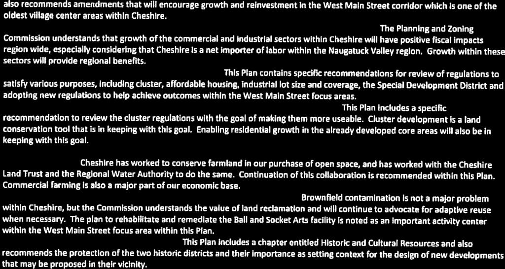
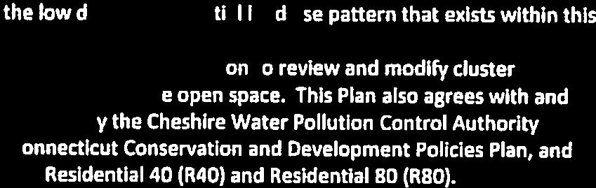
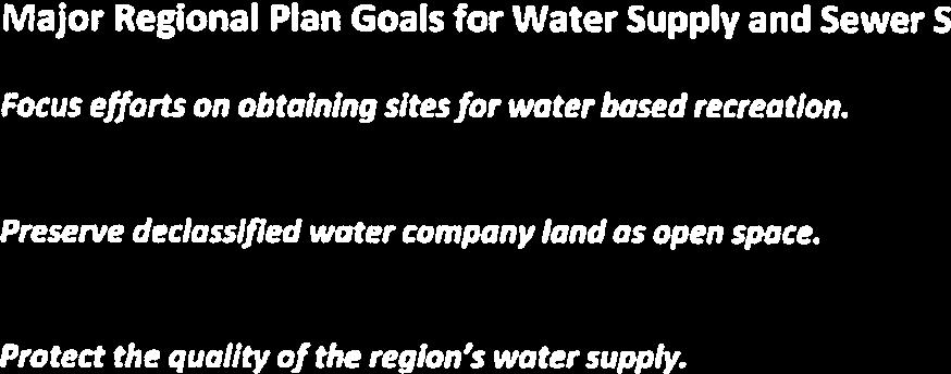
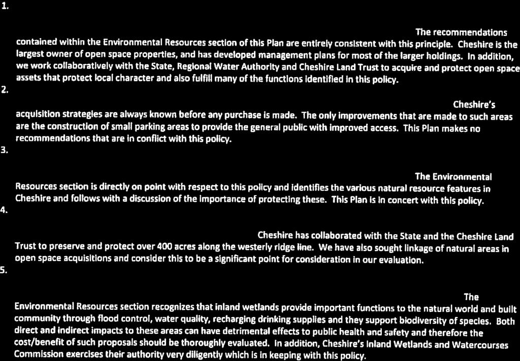
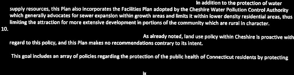
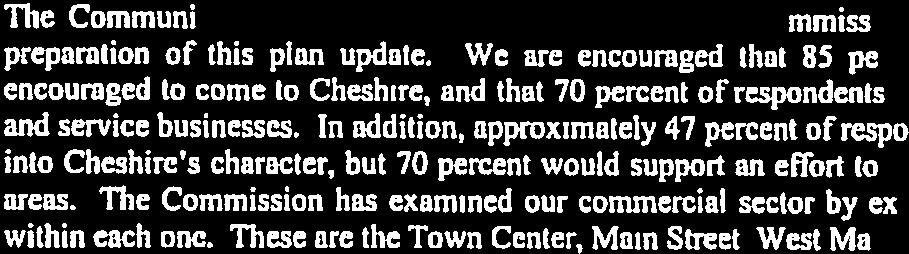
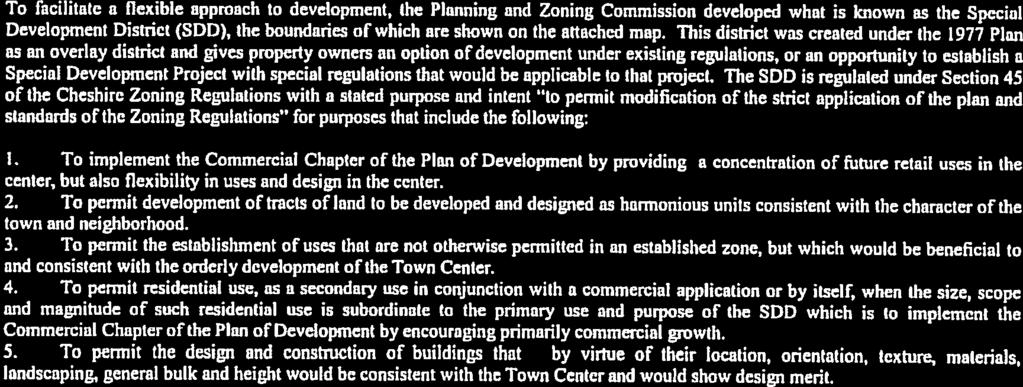
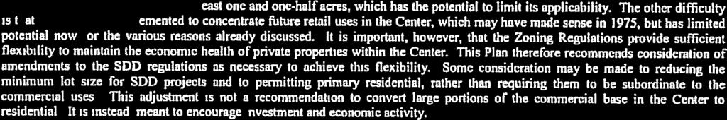
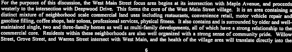
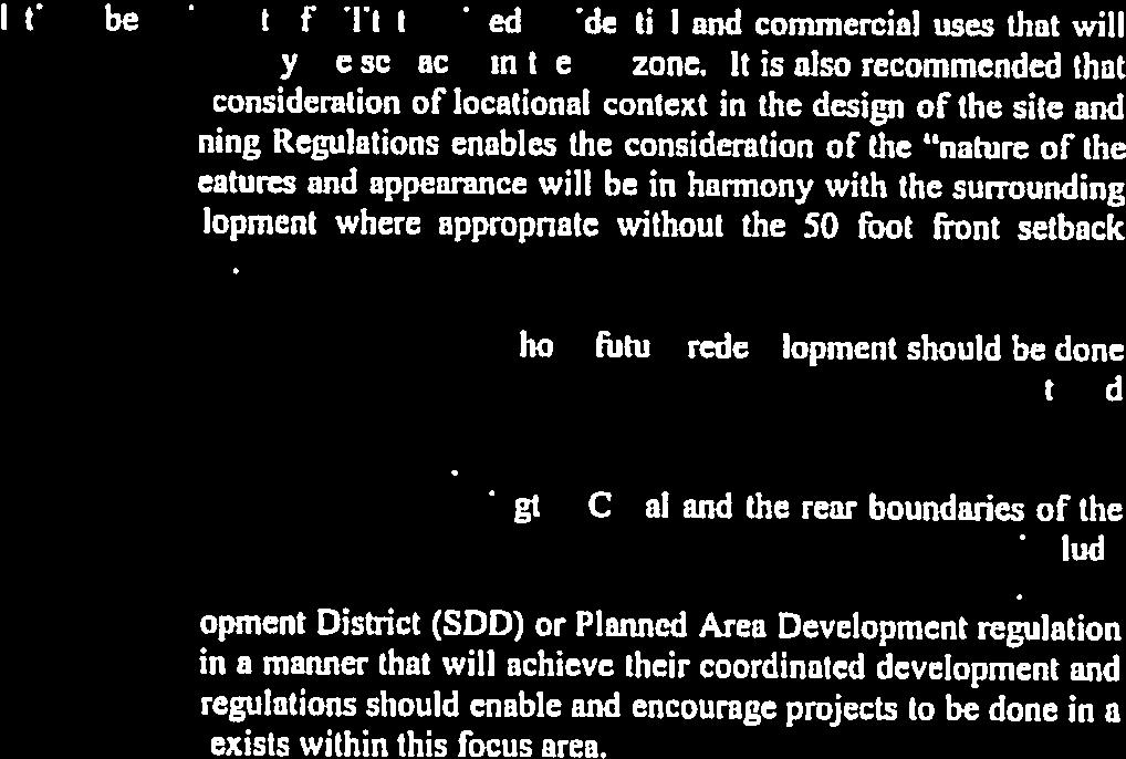
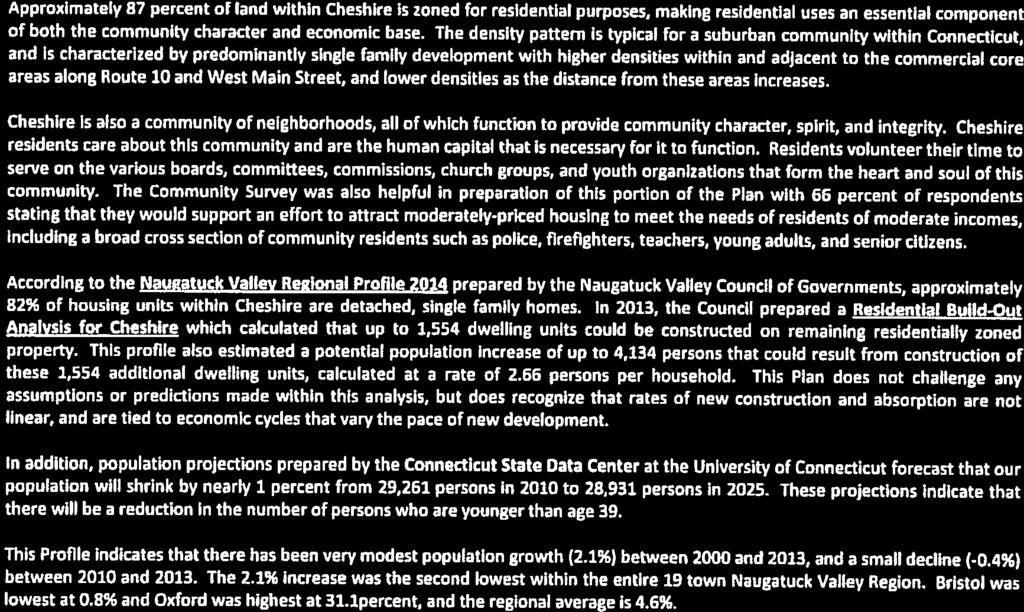
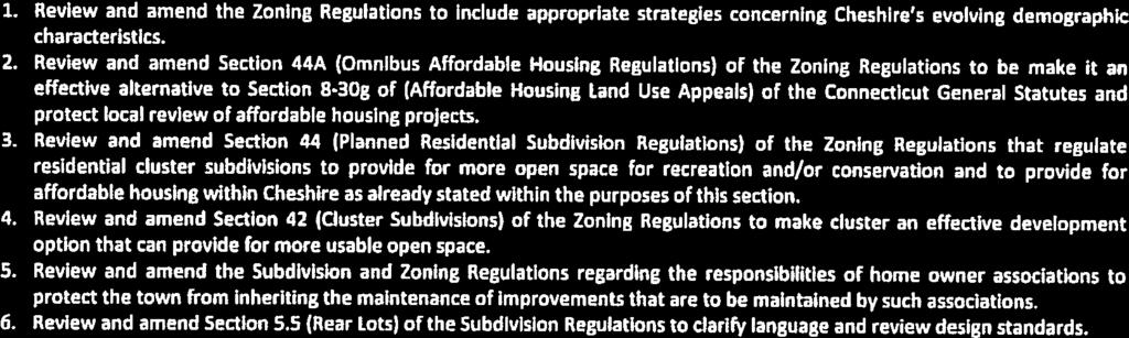
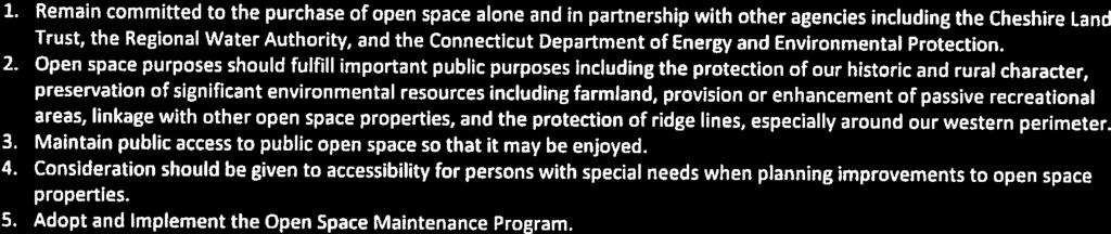
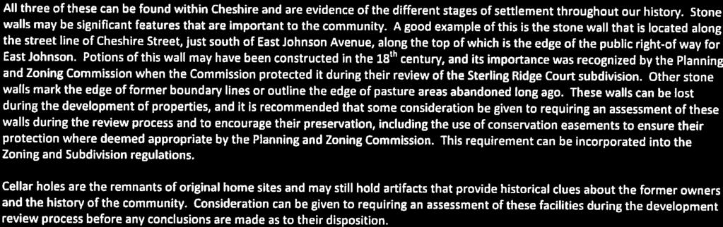
17 Town Center Focus Area HINMAN ST W MAIN ST Main Street Focus Area Zone Boundaries!( 68!( 70 MAIN ST Maplecroft Plaza C-2 HIGHLAND AVE!( 10 R-20A Cheshire Hillside Village Parcel Boundaries State Routes Streets Cornwall Avenue -Town Center Historic District Parking and Driveways Streams POND WETLAND Vegetation SPRING ST R-20A St. Peter's Church Location Map CORNWALL AVE R-20 Congregational Church R-20A Board of Education Temple Beth David R-20A Town Hall C-1 Cheshire Academy Watch Factory Old Town Crossing WALNUT ST WALLINGFORD R-40!( 68 Watch Factory Housing RD ACADEMY RD ") 70 ") 10 ") 70 ") 68 ") 68 ") 42 Cheshire Feet LANYON DR C-2 R-20 I For planning purposes only. Delineations may not be exact. 1a NAUGATUCK VALLEY COUNCIL of GOVERNMENTS
18
19

20
21
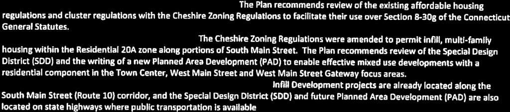
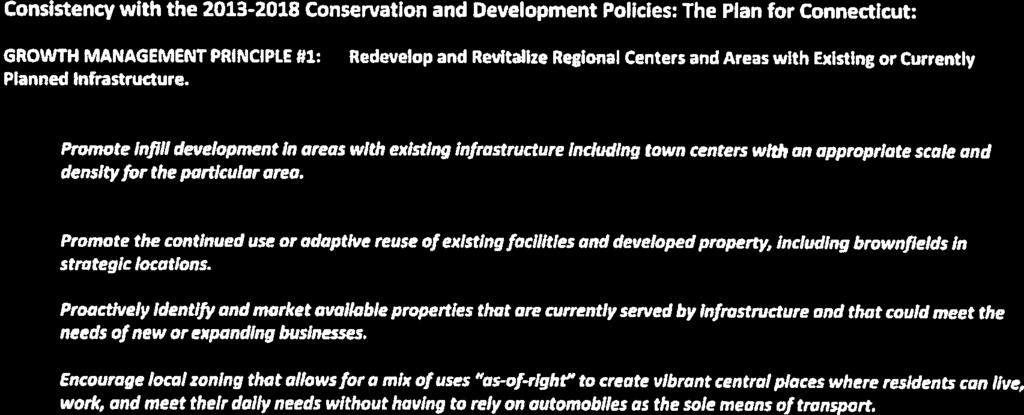
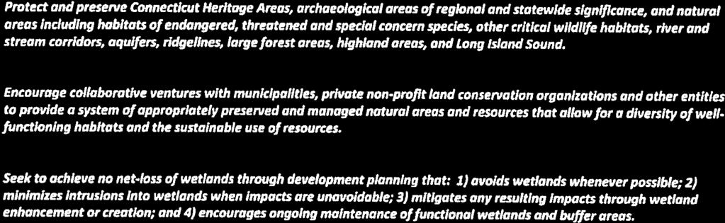
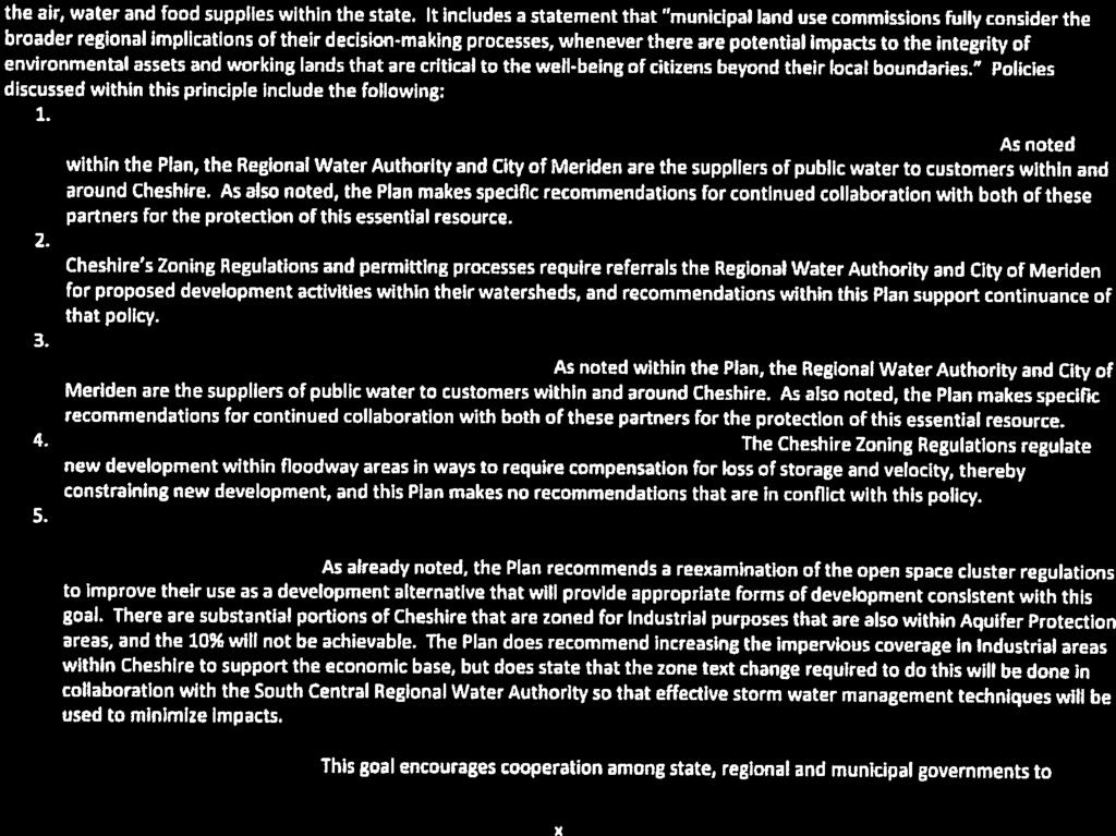
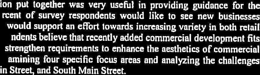
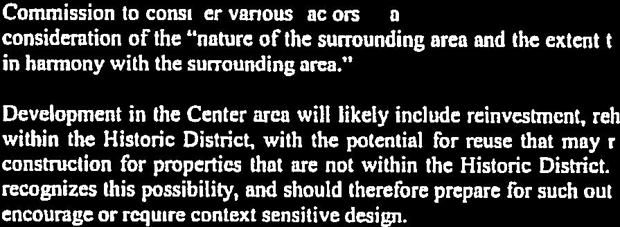
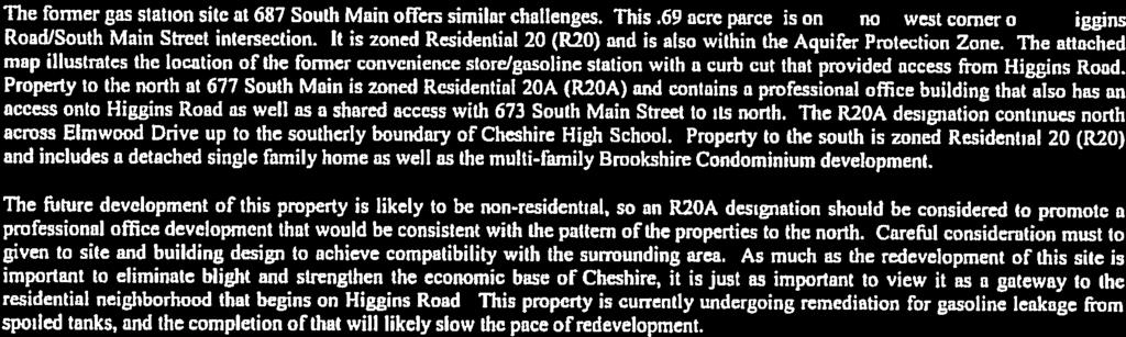
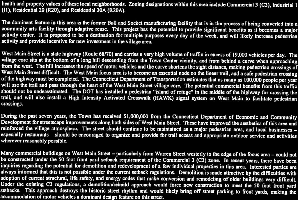
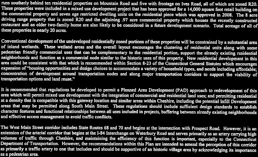
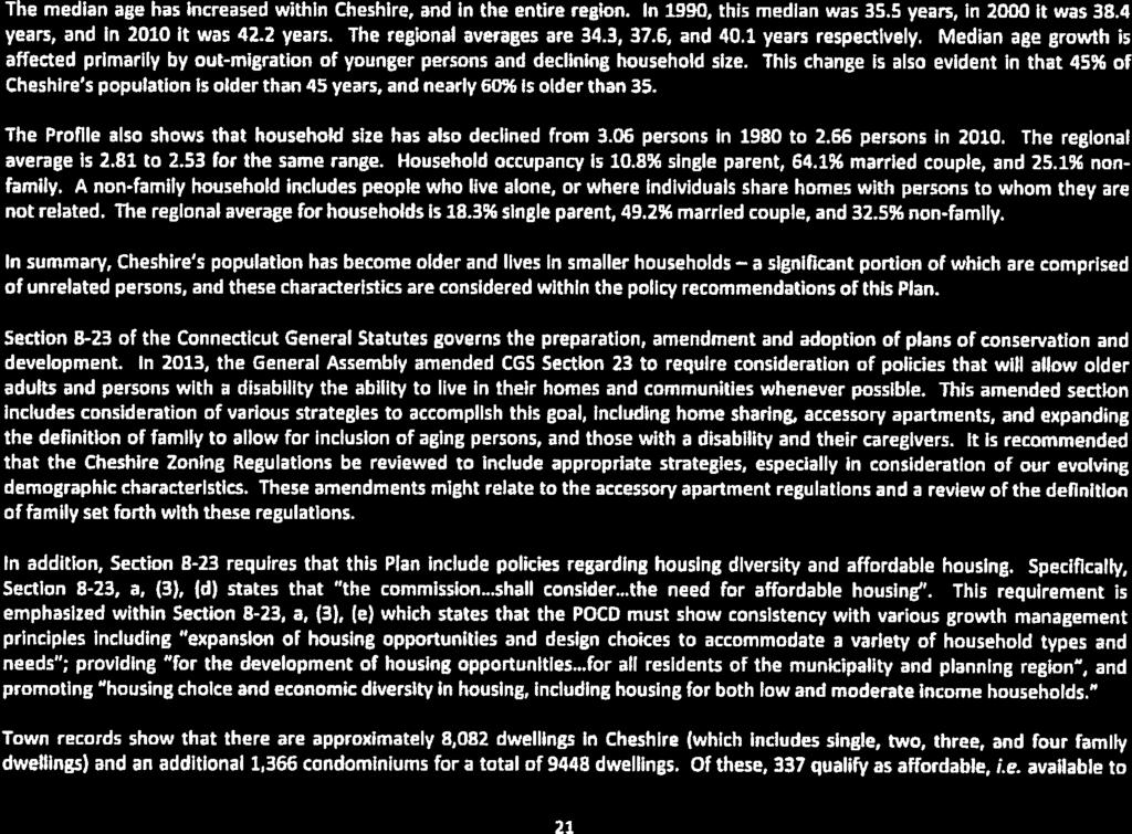
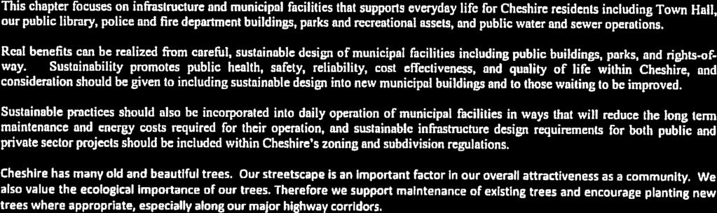
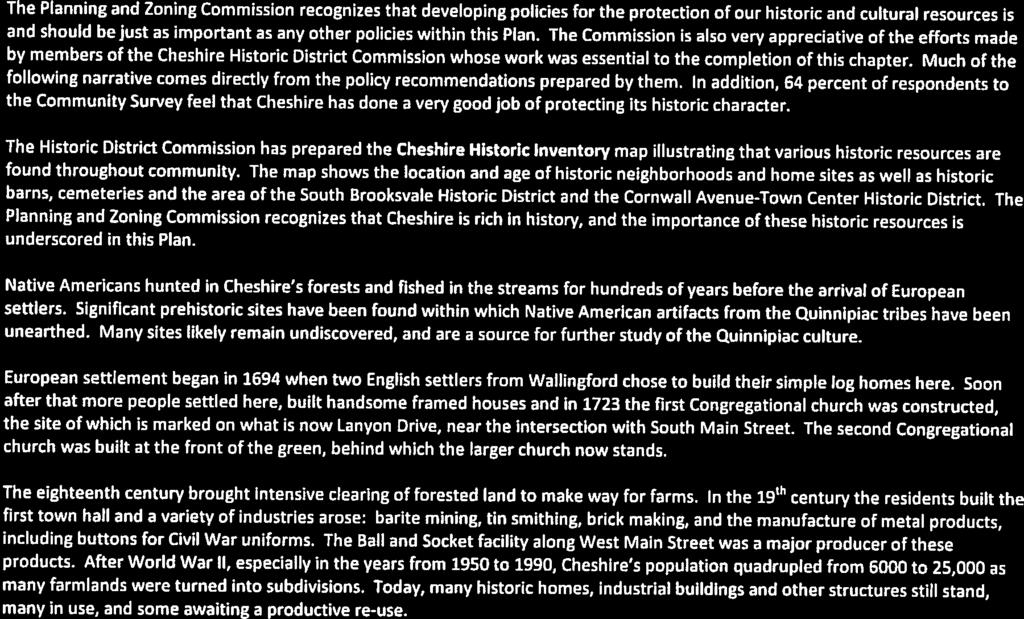
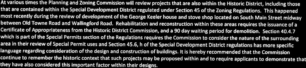
22 Main Street Focus Area MUELLER AVE Main Street Focus Area HINMAN ST Zone Boundaries Historic Buildings!( 68!( 70 W MAIN ST ST GEORGE AVE Hardware Store R-20A C-2 Fire Department Senior Center Building Structures Parcel Boundaries State Routes Streets Parking and Driveways Streams POND WETLAND Vegetation Feet CHERRY ST St. Bridget's School & Church SPRING R-20 ST C-3 QUELL CT Post Office C-2 Pharmacy MAIN MAIN MAIN ST ST ST HORTON AVE R-20A Library HIGHLAND AVE!( 10 S MAIN ST HIGHLAND AVE Location Map I ") 70 ") 10 ") 42 ") 70 ") 68 ") 68 Cheshire For planning purposes only. Delineations may not be exact. 5a NAUGATUCK VALLEY COUNCIL of GOVERNMENTS
23
24
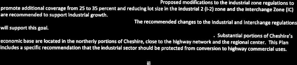
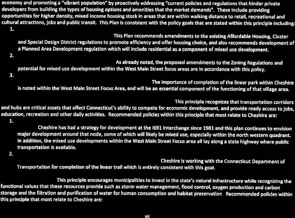
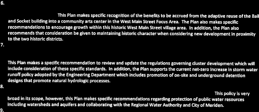
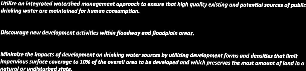
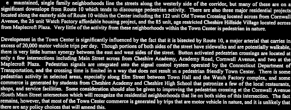
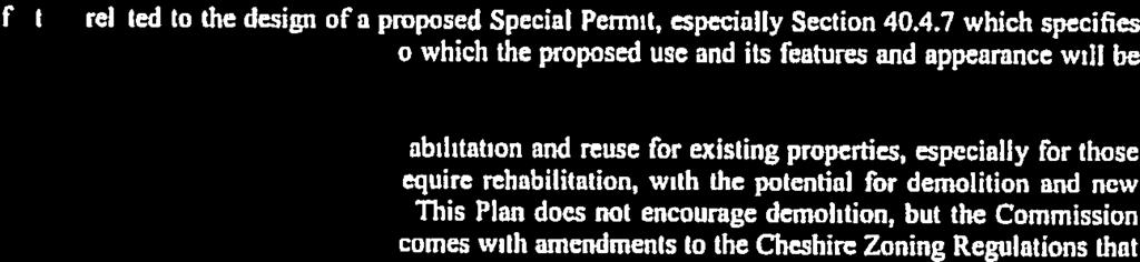
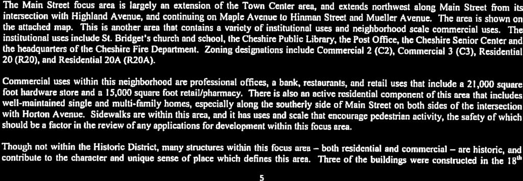
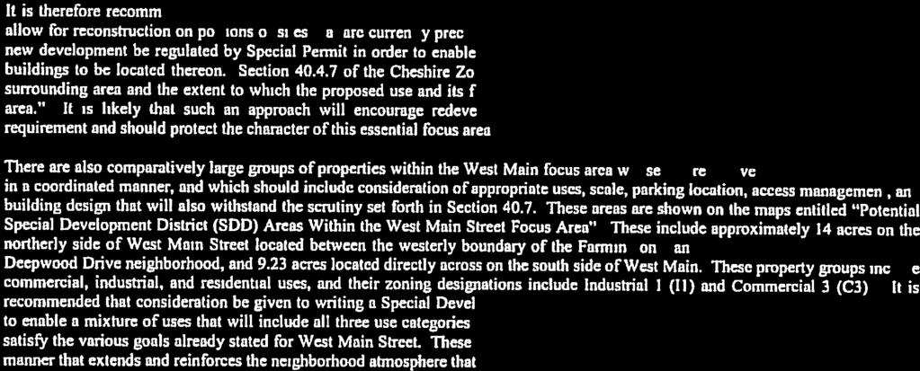
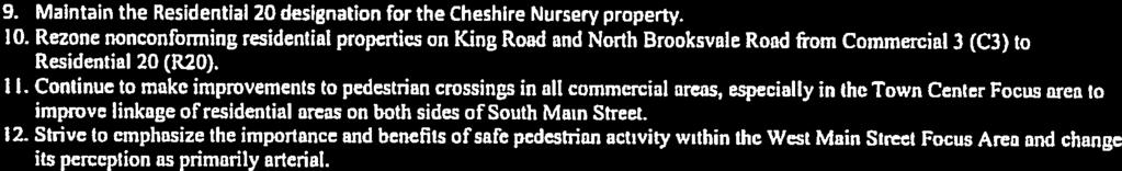
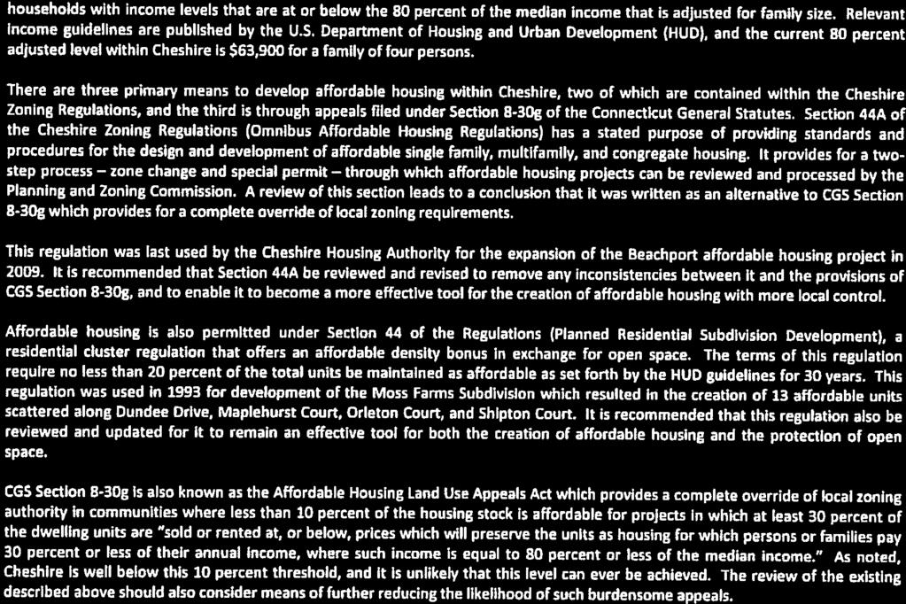
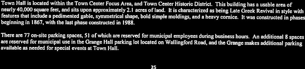
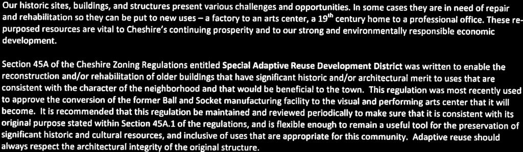
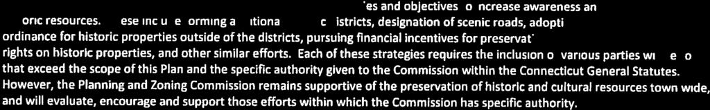
25 West Main Street Focus Area West Main Street Focus Area Potential Special Development District (SDD) Areas R-20 DEEPWOOD DR C-3 I-1 R-20 Future Farmington Canal Trail R-20A Zone Boundaries State Routes Building Structures Parcel Boundaries Streets Parking and Driveways Future Farmington Canal Trail Streams POND WETLAND Vegetation I-1 C-3 Feet I-1 Former Ball and Socket Manufacturing Co. WILLOW ST C-3 WARREN ST R-20A R-20 W MAIN ST R-20 AHD R-20 WILLIAMS RD R-20A WAVERLY ST!( 70!( 68 CHERRY ST R-20A C-3 MAPLE AVE MAIN ST Location Map I ") 70 ") 10 ") 42 ") 70 ") 68 ") 68 Cheshire For planning purposes only. Delineations may not be exact. 7a NAUGATUCK VALLEY COUNCIL of GOVERNMENTS
26

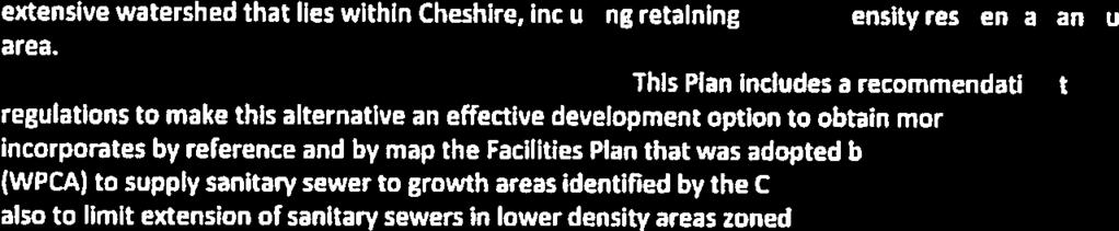
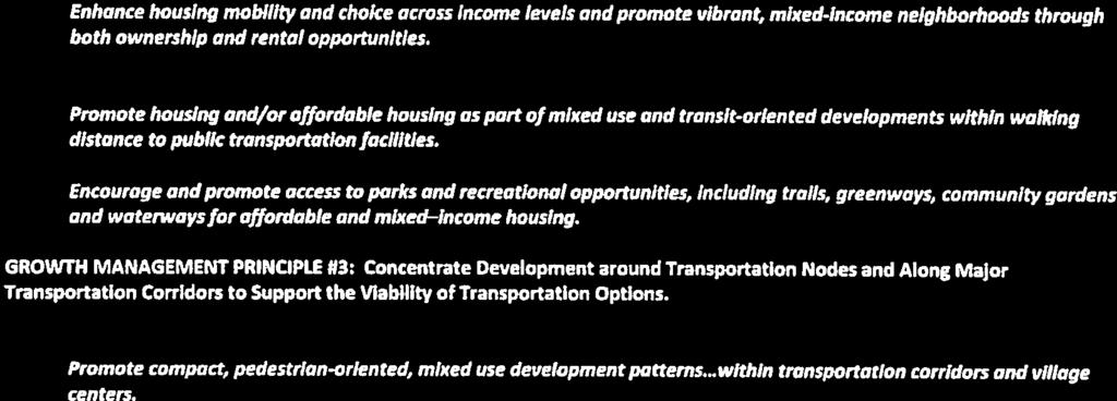
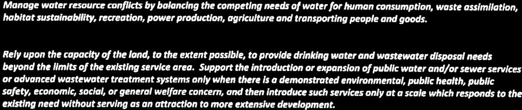
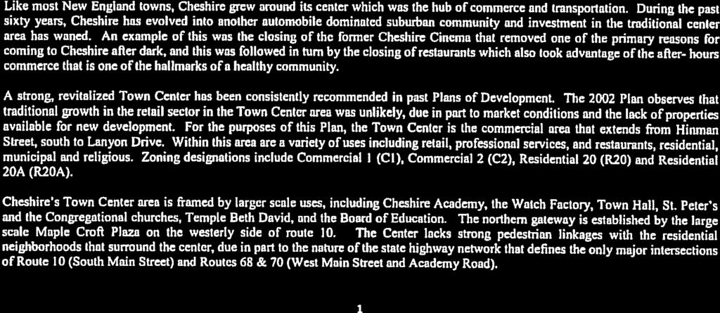
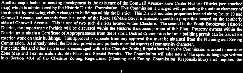
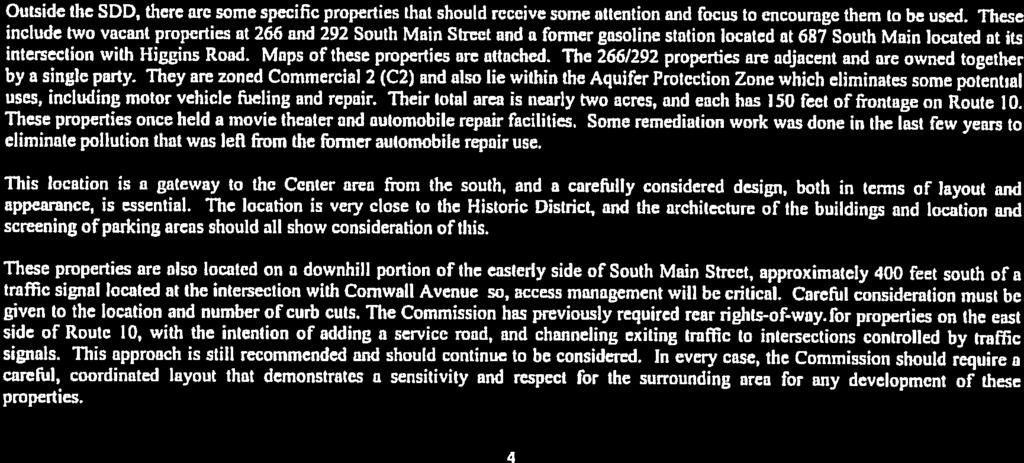
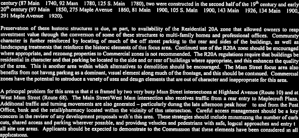
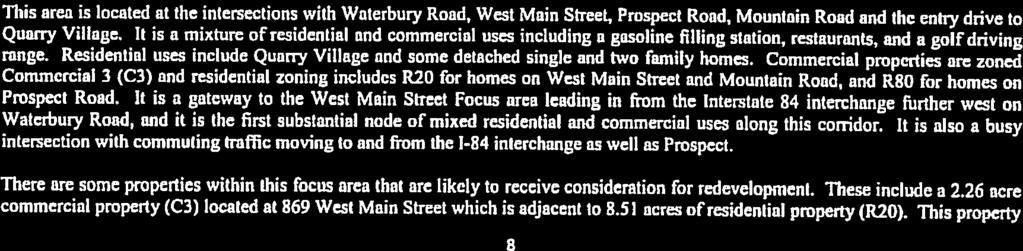
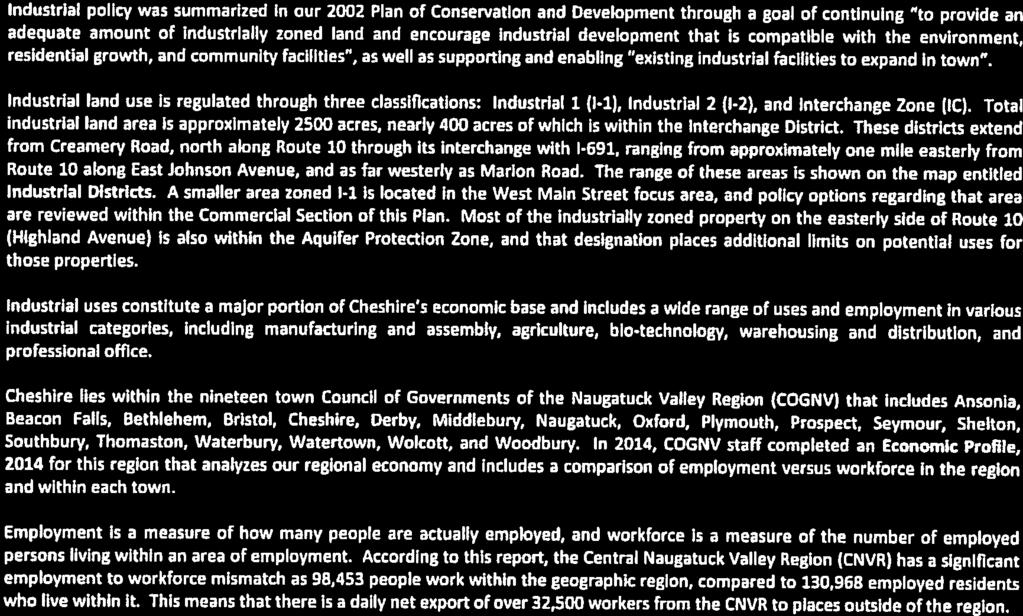
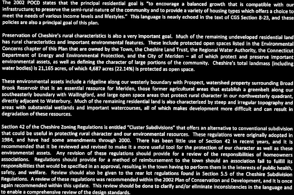
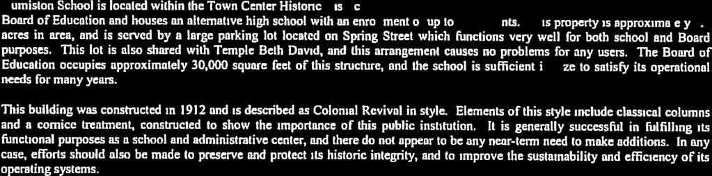
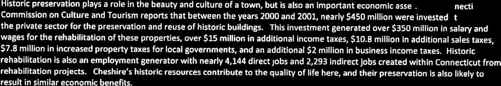
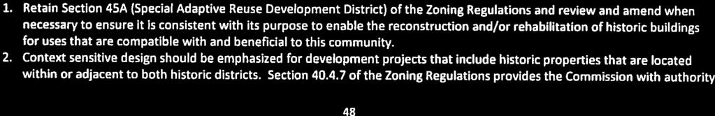
27 West Main Street Gateway Focus Area!( 70 R-80 Quarry Village R-20 R-20 WATERBURY ROAD PROSPECT ROAD C-3 MOUNTAIN ROAD 869 West Main St WEST MAIN STREET West Main Street Gateway Focus Area Zone Boundaries State Routes Building Structures Parcel Boundaries Streets Parking and Driveways Streams POND WETLAND Vegetation Location Map!( 68 R-80 R-20!( 68!( ") 10 ") 70 ") 70 ") 68 ") 68 ") 42 Cheshire Feet a I For planning purposes only. Delineations may not be exact. NAUGATUCK VALLEY COUNCIL of GOVERNMENTS
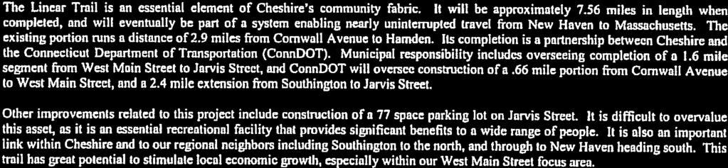
28

29


30
31
32 South Main Street Focus Area ARPRD Stonegate R-20A 802 S Main South Main Street Focus Area Zone Boundaries!( S Main (Bovano Industries) JINNY HILL RD Parcel Boundaries Building Structures State Routes Streets R-20A!( 10 Parking and Driveways POND WETLAND MANSION RD Vegetation Streams N BROOKSVALE RD C-3 Location Map S MAIN ST POUND RIDGE RD BRENTWOOD DR R-20 KING RD RABIDEAU CIR C-2 R-20A SCCRWA ") 10 ") 70 Cheshire ") 70 ") 68 ") 68 BATES DR Cheshire Nursery R-40 ") 42 BATES DR SOUTHWICK CT Feet ,000 I For planning purposes only. Delineations may not be exact. 12a NAUGATUCK VALLEY COUNCIL of GOVERNMENTS
33

34
35

36
37
38
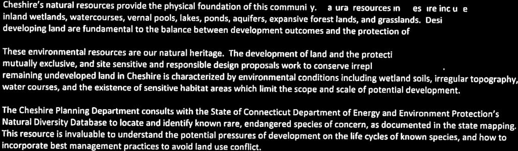
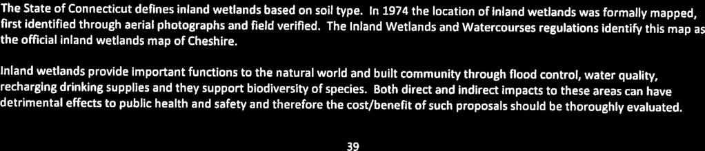
39


 42 CREAMERY RD Feet 0 500 1,000 2,000 JARVIS ST I For planning purposes only.")
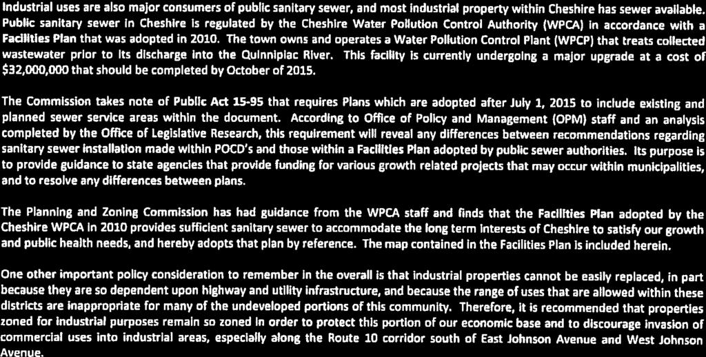
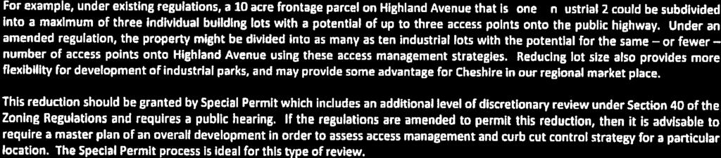
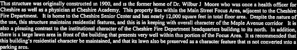
40 Industrial Districts MARION RD SOUTHINGTON BLOOMINGDALE DR KNOTTER DR EXIT 2 I 691 W W JOHNSON AVE I-2 DICKERMAN RD DICKERMAN RD REINHARD RD SCHOOLHOUSE RD!( 10 I DIANA CT MAC CAUSLAND CT SOUTHINGTON Cheshire Town Boundary Zone Boundaries Interstate Parcel Boundaries State Routes Streets Building Structures Parking and Driveways Streams POND WETLAND Vegetation Location Map PECK LN I-1 INDUSTRIAL AVE HIGHLAND AVE BLACKS RD ") 10 ") 70 Cheshire ") 68 ") 68 ") 70 SANDBANK RD REALTY DR ") 42 CREAMERY RD Feet ,000 2,000 JARVIS ST I For planning purposes only. Delineations may not be exact. 19a NAUGATUCK VALLEY COUNCIL of GOVERNMENTS


 42 For planning purposes only.")
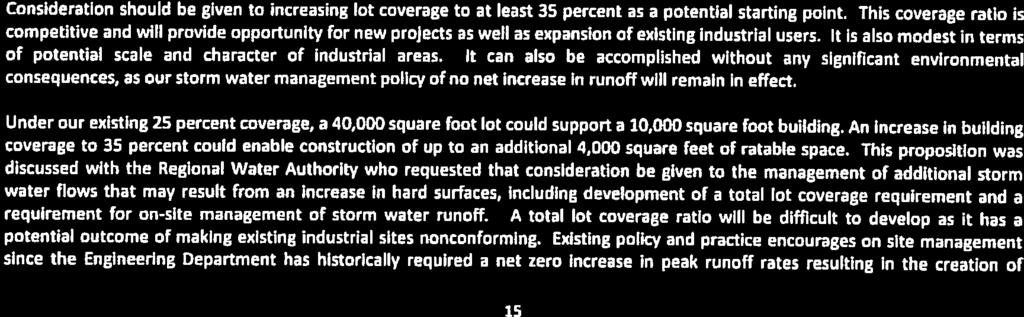
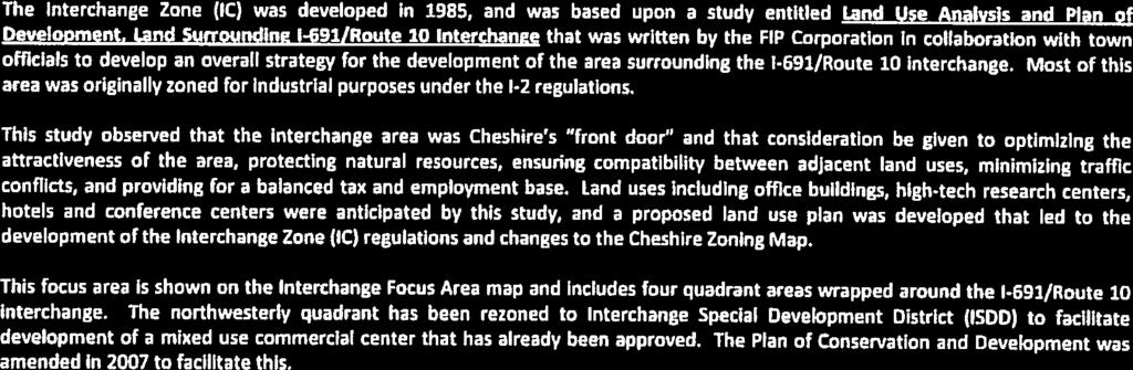
41 Interchange Focus Area Interstate Cheshire Town Boundary Zone Boundaries Parcel Boundaries SOUTHINGTON State Routes Streets Building Structures Parking and Driveways Streams POND Commuter Parking I-C WETLAND Vegetation CNV_CT911_roads selection ISDD Location Map W JOHNSON AVE I-C!( I-C ") 10 ") 70 Cheshire ") 68 ") 68 ") 70 Feet ,000 REINHARD RD HIGHLAND AVE E JOHNSON AVE DIANA CT I ") 42 For planning purposes only. Delineations may not be exact. 19b NAUGATUCK VALLEY COUNCIL of GOVERNMENTS
42
43
44
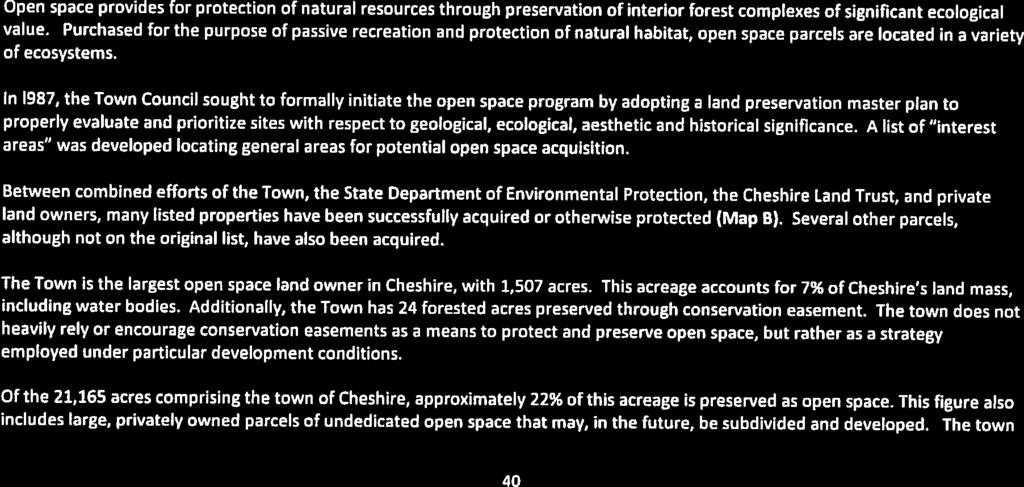
45
46

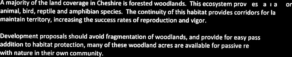
47
48


49

50
51
52

53
54

55

56
57
58

59

60
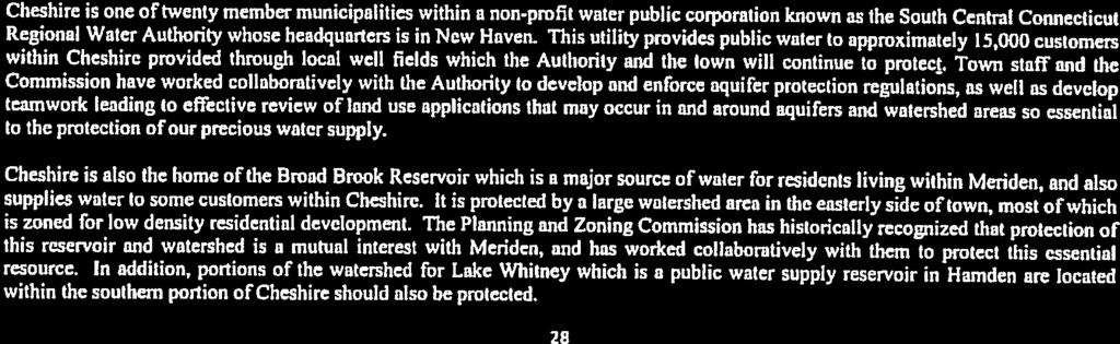
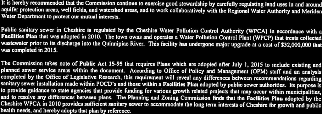
61 Functional Classification of Roads Southington Wolcott 691 Waterbury 84 Meriden Water Æÿ 70 Urbanized Area Functional Classification Principal Arterial - Interstate Principal Arterial - Other Prospect Æÿ 68 Æÿ 10 Æÿ 70 Minor Arterial Collector Minor Collector Æÿ 68 Æÿ 68 Broad Brook Reservoir Local Roads Æÿ 42 Wallingford Bethany Hamden 37b Miles I For planning purposes only. Delineations may not be exact. NAUGATUCK VALLEY COUNCIL of GOVERNMENTS


62

63

64


65
66
67
68
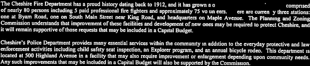
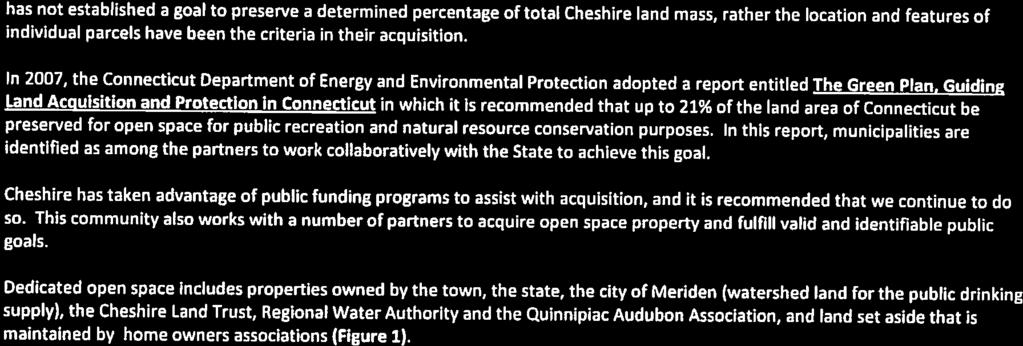
69 Existing Open Space Southington Æÿ322 Wolcott 691 Interstate Dime Savings State Route 84 Waterbury Mixville Hills Mixville Park Prospect Casertano Æÿ 70 Æÿ 68 Ten Mile Lowlands Æÿ 10 Cheshire Park Ives Farm Quinnipiac Recreation Area Broad Brook Reservoir Meriden Local Roads Stream Intermittent Water Water South Central Regional Water Authority Quinnipiac Valley Audubon Town State of CT Private Open Space Land Trust Meriden Water Company Puchalski Property Bartlem Park Roaring Brook Æÿ 42 Boulder Knoll Wallingford Bethany Naugatuck State Forest DeDominicis Hamden Miles I For planning purposes only. Delineations may not be exact. 44a NAUGATUCK VALLEY COUNCIL of GOVERNMENTS
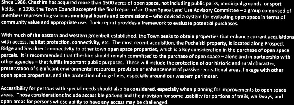
70 Watershed/Watercourses Wolcott Judd Brook Southington 691 Æÿ322 Interstate State Route Waterbury 84 Æÿ 70 Cuff Brook Ten m ile River Honeypot Brook Quinnipiac River Meriden Local Roads Water Drainage Ditch Intermittent Water Water SUBREGIONAL BASIN Beaver Pond Brook Mountain Brook Broad Brook Mad River Prospect Wi Æÿ 68 llow Brook Æÿ 10 Mill River Æÿ 68 Æÿ 70 Æÿ 68 Broad Brook Broad Brook Reservoir Mill River Quinnipiac River Tenmile River Willow Brook Roaring Brook Æÿ 42 Wallingford San fordbrook Bethany Brooksvale Stream Hamden 44b Miles I For planning purposes only. Delineations may not be exact. NAUGATUCK VALLEY COUNCIL of GOVERNMENTS
71
72
73


74
75
76
77


78
79

80

81
82

83
84


85
86
87
Cheshire Fire Department Monthly Report July 2015
 Cheshire Fire Department Monthly Report The month of July was busy for the Cheshire Fire Department. We responded to 56 calls for service which resulted in approximately $4,500 dollar loss. Despite the
2040 Long Range Transportation Plan
 2040 Long Range Transportation Plan Adopted: April 15, 2013 APPENDIX D HIGHWAY NEEDS PLAN PROJECTS FREDERICKSBURG Existing and Committed Projects Fall Hill Avenue/Mary Washington Blvd. (Fredericksburg)
City of Meriden Harbor Brook Flood Control Project Overview
 City of Meriden Harbor Brook Flood Control Project Overview Updated August 2013 OVERVIEW The center of Meriden, including the HUB site is the low point of the town which is ringed by basalt ridges. Running
GOCO Grants Awarded to Projects in Arapahoe County through June 2015
 Grant Type Open Space Fiscal Year Applicant Project Title Grant Amount 2015 City of Aurora Acres Protected Triple Creek Greenway Corridor Phase 3 $2,050,000.00 0 Planning 2015 Arapahoe County High Line
BALL CAMP PIKE Phase II From Middlebrook Pike to Andes Road NEW CONSTRUCTION Spring 2007
 COUNTY LOCAL PROJECTS BALL CAMP PIKE Phase II From Middlebrook Pike to Andes Road NEW ION Spring 00 DRY GAP PIKE From Dante Road to Beaver Creek WIDENING Summer 00 DUTCHTOWN ROAD From Pellissippi Parkway
BEACON FALLS PLAN OF CONSERVATION AND DEVELOPMENT
 BEACON FALLS PLAN OF CONSERVATION AND DEVELOPMENT DRAFT Submitted To Beacon Falls Land Planning and Zoning Commission April 11, 2013 P.O. Box 117, Cheshire, CT 06410 TEL 203.271.2458 www.turnermillergroup.com
Weston Conservation Commission
 Weston Conservation Commission Commission Roles and Responsibilities Laws that protect Wetlands What residents can do to protect wetlands and open space 1 Conservation Commission Made up of 7 volunteer
2.0 Hi s t o r y & Existing Co n d i t i o n s
 2.0 Hi s t o r y & Existing Co n d i t i o n s 2.1 Plan Area History The Lincoln East Specific Plan (Specific Plan) area is a significant part of the history of Sutter County. A 48,000 acre land grant
Panel Discussion: Developing Economically Sustainable Communities
 Panel Discussion: Developing Economically Sustainable Communities Evolving Trends and Issues Mark Nielsen Director of Planning NVCOG Boston Springfield Connecticut Hartford Providence Danbury Stamford
6: 2417 Fourth Line, Sixteen Hollow, Lion Valley Park
 1. Description of Property 6: 2417 Fourth Line, Sixteen Hollow, Lion Valley Park Municipal Address 2417 Fourth Line ame (if applicable) Sixteen Hollow, Lion Valley Park Legal Description CO 1 SDS PT LOTS
TOWN OF SPRINGFIELD, NEW HAMPSHIRE
 TOWN OF SPRINGFIELD, NEW HAMPSHIRE NATURAL RESOURCES INVENTORY EXECUTIVE SUMMARY March 2008 Prepared by: Watershed to Wildlife, Inc. Natural Resource Consultants 42 Mill Street, Suite 3 Littleton, NH 03561
CITY OF BOYNTON BEACH SE 1 ST STREET COMPLETE STREETS IMPROVEMENTS
 CITY OF BOYNTON BEACH SE 1 ST STREET COMPLETE STREETS IMPROVEMENTS N Project Location -Town Square -Villages at Ocean SE 1st St, between E Woolbright Rd and SE 2nd Ave Project Location -Boynton One -Publix
CHAPTER 2 SUMMARY 1. PROJECT SUMMARY DATA
 CHAPTER 2 SUMMARY This is an Initial Study format used to determine, pursuant to CEQA Guidelines Section 15177, whether a project 1) is within the scope of a Master EIR (MEIR), 2) may result in additional
Resilience Research, Policy, and Planning in Connec3cut
 Resilience Research, Policy, and Planning in Connec3cut Dr. Rebecca A. French Director of Community Engagement Connec2cut Ins2tute for Resilience and Climate Adapta2on Rebecca.French@uconn.edu Rising Tides:
Regional Planning Commission
 SOUTH CENTRAL CONNECTICUT Regional Planning Commission RPC Representatives Bethany: Michael Calhoun Branford: Charles Andres To: From: Subject: Regional Planning Commission Eugene Livshits, Regional Planner
Edmond Plan IV Update 2016, Descriptions and Recommendations for future Land Use for the Far Northeast Neighborhoods.
 TO: FROM: Edmond Planning Commission Robert L. Schiermeyer, City Planner DATE: October 2016 RE: Edmond Plan IV Update 2016, Descriptions and Recommendations for future Land Use for the Far Northeast Neighborhoods.
FOR SALE: LAND Military Road Cottage Grove, MN ACRES READY FOR DEVELOPMENT! 2 PARCELS FACTS & FEATURES
 FOR SALE: LAND FACTS & FEATURES List Price: $825,000 - Will Review All Offers Residential or Mixed-Use Development Possible Potentially Up to 34 Acres Available Total Acreage - 2 Parcels: 10.72 Acres Price
For Date: 03/12/ Sunday
 MARION POLICE DEPARTMENT Page: 1 For Date: 03/12/2017 - Sunday all Number Time Call Reason Action Priority 17-1976 0012 General Service Services rendered 3 17-1977 0823 EMS - Medical Removed to hospital
Conservation Development
 Acknowledgements RIDEM: Scott Millar Anthony Lachowicz-Planning and Zoning Consultant Director of Planning 1 : a creative land use technique that allows a community to guide growth to the most appropriate
Information for File #MVP MVM
 Information for File #MVP-2004-02804-MVM Applicant: St. Michael MF, LLC Corps Contact: Marissa Merriman Address: 180 Fifth Street East, Suite 700, St. Paul, Minnesota 55101-1678 E-Mail: Marissa.V.Merriman@usace.army.mil
St. Croix County Shoreland Overlay Zoning Districts. Public Hearing Community Development Committee December 19, 2013
 St. Croix County Shoreland Overlay Zoning Districts Public Hearing Community Development Committee December 19, 2013 Timeline CDC Review October 17 Public Information Meeting October 29 (6:00-8:00 pm)
A G E N D A Council Update Training Room September 26, :45 p.m.
 CITY OF THORNTON CITY MANAGER S OFFICE A G E N D A Council Update Training Room September 26, 2017 5:45 p.m. A. Boards and Committees Reports (Estimated 20 Minutes) 1. Rangeview Library District Meeting
TOWN OF EAST GRANBY INCORPORATED 1858
 TOWN OF EAST GRANBY INCORPORATED 1858 PLANNING and ENGINEERING PO BOX 1858 9 CENTER ST EAST GRANBY, CONNECTICUT 06026 1-860-653-3444 FAX 1-860-653-4017 PLANNING & ZONING REVIEW REPORT Date: Re: PZC 14-08
Town Center. Block 5 Existing multifamily residential units are expected to remain.
 Area Guidelines Germantown s districts should be developed as distinct communities with unique features that are supported through the guidelines. The guidelines not only help distinguish these districts
Moon Brook FRP BMP Summary Sheet. Ownership of Land where BMP is Located
 Outlet Retrofit Hitzel Terrace The town owned parcel along Hitzel Terrace is a natural wetland area which currently provides some level of stormwater detention and peak-flow attenuation. The proposed project
-MENDOCINO COUNTY PLANNING AND BUILDING SERVICES- DIVISION II OF TITLE 20--COASTAL ZONING CODE
 CHAPTER 20.504 VISUAL RESOURCE AND SPECIAL TREATMENT AREAS Sec. 20.504.005 Applicability. Sec. 20.504.010 Purpose. Sec. 20.504.015 Highly Scenic Areas. Sec. 20.504.020 Special Communities and Neighborhoods.
Chapter V-Transportation
 Town of Vernon 2026 Smart Growth Plan Chapter V-Transportation DEVELOPMENT OBJECTIVES Transportation System Objective - To provide an integrated transportation system which, through its location, capacity,
NAPA COUNTY LAND USE PLAN
 NAPA COUNTY LAND USE PLAN 2008-2030 * LEGEND URBANIZED OR NON-AGRICULTURAL Cities Urban Residential Rural Residential Industrial Public-Institutional Study Area OPEN SPACE * * Agriculture, Watershed &
Major Subdivision Sketch Plan Checklist
 This checklist provides specific requirements that are apart of the Sketch process. The entire process is described by the Huntersville Subdivision Review Process which details all the submittal and resubmittal
COLLIER BOULEVARD (CR 951) CORRIDOR
 CORRIDOR") Project(s) Goals Improve Traffic Circulation, Capacity & Safety Focus on Safety During Design & Construction Address Public Concerns Design an Aesthetically Pleasing Project Limit Environmental Impacts
Project(s) Goals Improve Traffic Circulation, Capacity & Safety Focus on Safety During Design & Construction Address Public Concerns Design an Aesthetically Pleasing Project Limit Environmental Impacts
Trail Feasibility and Planning Project for Northern Dutchess County, New York
 for Northern Dutchess County, New York Funded in Part by Grants from the Hudson River Valley Greenway, Land Trust Alliance Conservation Partnership Program and the Thomas Thompson Trust 1 STEERING COMMITTEE
WORK SESSION STAFF REPORT Work Session Item No. 2. Michael Grochala, Community Development Director
 WORK SESSION STAFF REPORT Work Session Item No. 2 WS Item 2 Date: March, 2018 To: From: Re: City Council Michael Grochala, Community Development Director 200 Comprehensive Plan Mixed Use Districts Background
REQUEST FOR EXPRESSION OF INTEREST
 REQUEST FOR EXPRESSION OF INTEREST 1. NEDC / Request for Expression of Interest CONTENTS 3 Request for Expression of Interest 5 How to Respond to the Request for Expression of Interest 6 Transportation
ILLUSTRATIVE MASTER PLAN
 3 ILLUSTRATIVE MASTER PLAN Illustrative Master Plan 17 Illustrative Master Plan The Illustrative Master Plan depicted on the foldout sheets reflects the final master plan for the Manchester Road corridor,
North Oakville East Parks Facilities Distribution Plan. November, 2009
 North Oakville East November, 2009 POLICY CONTEXT 1) Purpose a) The purpose of this document is to be a guide for the location, configuration, design and development of the parks system for the North Oakville
AWH REPORT OF THE PLANNING AND DEVELOPMENT DEPARTMENT FOR APPLICATION FOR REZONING ORDINANCE TO PLANNED UNIT DEVELOPMENT
 AWH REPORT OF THE PLANNING AND DEVELOPMENT DEPARTMENT FOR APPLICATION FOR REZONING ORDINANCE TO PLANNED UNIT DEVELOPMENT MAY 8, 2014 The Planning and Development Department hereby forwards to the Planning
SECTION 9 PUBLIC FORUM DRAFT 5/31/2017 SEVEN YEAR ACTION PLAN
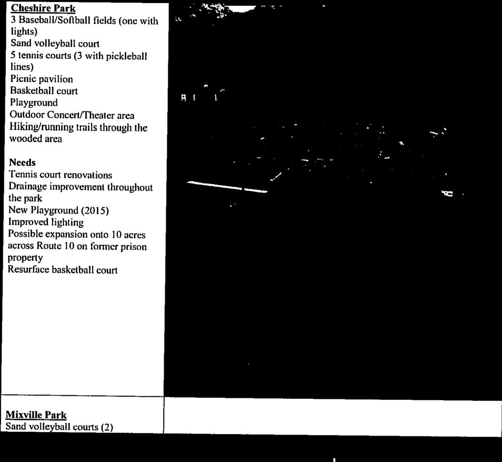
 SECTION 9 SEVEN YEAR ACTION PLAN The Seven-Year Action Plan addresses the objectives of the Open Space and Recreation Plan and identifies actions to meet these objectives. While the Open Space and Recreation
2.4 COMMERCIAL POLICIES
 2.4 COMMERCIAL POLICIES The major goal of the commercial sector is to create a distinct and viable commercial district that will provide a variety of commercial services to meet the needs of both the local
Central and East Neighbourhoods - Hermitage Outline Plan
 Central and East Neighbourhoods - Hermitage Outline Plan Office Consolidation September 2013 Prepared by: Planning and Policy Services Branch Planning and Development Department City of Edmonton The Central
6-GATEWAYS, WAYFINDING & PUBLIC SIGNS
 6-GATEWAYS, Wayfinding & ublic Signs 6-GATEWAYS, WAYFINDING & UBLIC SIGNS Downtown Georgetown has a strong base of local users as well as seasonal tourists and visitors. Many first-time visitors, and those
Conceptual Review Agenda
 Conceptual Review Agenda March 9, 2009 9:30 10:00 10:30 11:00 11:30 Project: Little Gadgets Daycare Center Church expansion to include café and events center Location: 363 Jefferson (Iasis Church) Applicant:
1. Parks & Recreation Neighborhood Parks Community Parks Special Use Sites 2. Open Space 3. Trails
 Appendix A: Park Classifications The intent of parks and recreation classifications is to aid in making acquisition and design decisions for park sites, facilities and the organization of recreation space
BYLAW NO. 3549/2015. Being a Bylaw of The City of Red Deer to provide a uniform levy of off-site costs in respect of previously undeveloped land.
 BYLAW NO. 3549/2015 Being a Bylaw of The City of Red Deer to provide a uniform levy of off-site costs in respect of previously undeveloped land. 1 WHEREAS pursuant to provisions of Section 648 of the Municipal
Watertown City Council
 City of Watertown Watertown City Council April 14 th, 2015 Agenda Item: City Comment on Sun Share CUP Application Request for Action: Motion to Approve City Comments regarding CUP Application Department:
Planning Districts INTRODUCTION
 INTRODUCTION To facilitate detailed examination of development prospects for all areas of the community, Delano has been divided into 14 planning districts. The location of these planning districts is
Stafford VDOT Cooperative Activities
 Stafford VDOT Cooperative Activities February 21, 2012 General Areas of Cooperation Financial Road Safety & RTMP Design County Projects VDOT Projects Street Acceptance Rural Addition/Rural Paving Maintenance
TRUCKEE. Fire and EMS Combined List by Incident Number. Alarm Date Between {01/01/2018} And {01/31/2018}
 Alarm Between {01/01/2018} And {01/31/2018} 18-0000002-0 FIRE 01/01/2018 Hwy 267 & Northstar DR 3214 EMS call, UTL 18-0000005-0 FIRE 01/01/2018 10000 Spring ST 3212 EMS call, cancelled en 18-0000025-0
Pequotsepos Brook Preserve
 AVALONIA LAND CONSERVANCY, Inc. P.O. Box 49, Old Mystic, CT 06372 Pequotsepos Brook Preserve Property Management Plan Maritime Drive Mystic, New London County, Connecticut Stonington Town Committee is
Stakeholders Advisory Working Groups (SAWGs) Smart Growth and TOD Land Use (#11) SAWG Meeting
 Smart Growth and TOD Land Use (#11) SAWG Meeting") Presentation - Part II Tappan Zee Bridge/I-287 Corridor Project July 21, 2010 Slide 1. David Kooris (Regional Plan Association) welcomed members of the Land Use Stakeholders Advisory Working Groups (SAWGs)
Presentation - Part II Tappan Zee Bridge/I-287 Corridor Project July 21, 2010 Slide 1. David Kooris (Regional Plan Association) welcomed members of the Land Use Stakeholders Advisory Working Groups (SAWGs)
The urban parks in Charlottesville include Jackson Park, Lee Park, and McGuffey Park.
 Park Classifications Charlottesville s parks can be grouped into 4 different classifications: urban parks, neighborhood parks, community parks, and regional parks. Figure 1 on page 5 inventories the facilities
See Yellow Highlighted for Major Closures
 Projects Report Week of May 21-27, 2018 Street/Intersection From To CURRENT PROJECTS Ashcroft Ln. Cobblestone Row North Dead End 5/14/18 6/15/18 Ave. A Maple Eagle 3/19/18 6/30/18 Bonnie Brae St. Roselawn
Mendota Heights 2040 Comprehensive Plan Draft Vers
 4 Parks and Trails The City of Mendota Heights boasts a variety of recreational and open space opportunities. Few cities can claim access to regional trails, riverside and lakeside parks, scenic bluffs
NORTH BETHANY ELEMENTARY SCHOOL SITE ASSESSMENT
 NORTH BETHANY ELEMENTARY SCHOOL SITE ASSESSMENT Prepared for: Prepared by: October 10, 2014 Page 2 Introduction and Purpose This report provides an assessment of two potential sites for a new elementary
Const. ROADS - Description
 Road Projects make up the bulk of the capital expenditures for the township. For the term of this CIP, road projects total $9,843,000 or 72.0% of the total capital expenditures for all capital projects
4-Town Comprehensive Plan DRAFT 7/30/07
 4-Town Comprehensive Plan DRAFT 7/30/07 Acknowledgements ning Committee Town of Harrisburg Norman Roof Randy Nicol Town of Martinsburg Terry Thisse Paul Kelly Town of Montague Jan Bagdanowicz Wendy Perry
Warren County/Bowling Green Focus 2030 Comprehensive Plan VOLUME 1 INDEX
 Appendix 5: Index VOLUME 1 INDEX A Aesthetics ES-6, FLU-15, FLU-17, FLU-24, NCR-7 Agricultural Base FLU-18, FLU-20 Agricultural Centers, Rural FLU-11 Agricultural District NCR-17-NCR-18 Agricultural Economy
CHAPTER 7: Transportation, Mobility and Circulation
 AGLE AREA COMMUNITY Plan CHAPTER 7 CHAPTER 7: Transportation, Mobility and Circulation Transportation, Mobility and Circulation The purpose of the Transportation, Mobility and Circulation Chapter is to
SPG 1. * the northern and western sections which are open fields used for pasture and grazing;
 SPG 1 1.0 INTRODUCTION This development brief is based on the allocation of the Priors Hall site for employment and countryside recreational purposes in the Corby Borough Local Plan. The brief is intended
Southern Maine Retail Forecast. Presented by Peter Harrington
 Southern Maine Retail Forecast Presented by Peter Harrington 1 Greater Portland Vacancy Rates 12.00% 10.80% 10.00% 8.00% 6.00% 5.61% 6.93% 8.34% 6.17% 5.92% 4.00% 2.00% 2.94% 2.62% 4.29% 3.68% 3.60% 3.44%
Construction Projects Report. Week of June 25 - July 01, Proposed Date of Completion Brief Description of Construction Department Letters
 Projects Report Week of June 25 - July 01, 2018 Street/Intersection From To CURRENT PROJECTS Ashcroft Ln. Cobblestone Row North Dead End of 5/14/18 8/9/18 Ave. A Maple Eagle 3/19/18 6/30/18 Bonnie Brae
Project Goal. RRRC Living Towns Planning Workshp. Town of Halifax Revitalization Project. Dynamic Planning & Management Duo: July 12, 2006
 Project Goal Town of Halifax Revitalization Project RRRC Living Towns Planning Workshp July 12, 2006 Town of Halifax Halifax County *** Revitalization Project Goal*** To create Economic Opportunity and
TOWN OF BURLINGTON Conservation Commission
 TOWN OF BURLINGTON Conservation Commission MINUTES OF Approved May 26, 2016 Members Present: Members Absent: Also Present: Chair L. Cohen, K. Melanson, I. Deb, A. McNamara Vice-Chair W. Boivin, J. Lynch,
CHAPTER 12 OPEN SPACE AND WORKING LANDSCAPES
 CHAPTER 12 OPEN SPACE AND WORKING LANDSCAPES Maintaining open space and scenic, working landscapes are among Williston s most important goals for the future. The vision statement presented in Chapter 2
LANDSCAPE ARCHITECTURE - NEW JERSEY
 LANDSCAPE ARCHITECTURE - NEW JERSEY MD ANDERSON CANCER CENTER AT COOPER ROOFTOP GARDEN Camden NJ Cooper University Hospital Landscape Architecture Langan provided comprehensive planning design and construction
Conservatory Green, Stapleton s 8th great neighborhood.
 Conservatory Green, Stapleton s 8th great neighborhood. Rocky Mountain Arsenal National Wildlife Refuge Quebec St. Forward. LOOKING Dick s Sporting Goods Park School Stapleton s success over the years
2018 Eco-Friendly Garden Tour Maps & Directions
 2018 Eco-Friendly Garden Tour Maps & Directions On the Day Tour hours are 10 a.m. to 4 p.m. Bring an electronic or paper ticket with you to gain access to the gardens. Look for the Eco-Friendly Garden
Waukee. City of. The Key to Good Living
 Waukee City of The Key to Good Living City of Waukee FY15 - FY20 CIP Project Summary FY2015 FY2018 Parks Windfield Park Improvements Parks Centennial Park Amphitheater Parks Grant Park Improvements Parks
12600 S Existing Conditions
 STUDY AREA BOUNDARY Study Area Boundary Study Area Context The District Riverton Meadows Vista Station Mountain View Village Market Center 2 Mile Radius 12600 S Existing Conditions 12600 S is a river of
K+P TRAIL EXTENSION FEASIBILITY STUDY PRELIMINARY SITE ANALYSIS PLAN PREPARED FOR THE CITY OF KINGSTON NOT FOR CONSTRUCTION
 YY/MM/DD V:\2015\1415605-000 - Kingston K+P Trail Extension Feasibility\Drawings\K+P - Sheet Layout.dwg TITLEBLOCK: 790mm x 534mm OTTAWA LA 2014 PRELIMINARY SITE ANALYSIS PLAN PREPARED FOR THE NOT FOR
Planning Academy MARCH 8, 2015
 Planning Academy MARCH 8, 2015 Overview of Growth Management in Albemarle County Comprehensive Plans, Planning Initiatives Major Milestones Key Policies History Comprehensive Plan should precede Zoning
Alternatives Development Three conceptual alternatives were developed for the Race Road/Jessup Village Planning Study and are described below:
 Race Road/Jessup Village Planning Study (H550601) Project Newsletter Spring 2015 Project Description The Study Team, consisting of staff from Anne Arundel County (Department of Public Works and Department
13. PRELIMINARY PLAT NO MILLS FARM - Vicinity of the southeast corner of 159 th Street and Quivira Road
 13. corner of 159 th Street and Quivira Road 1. APPLICANT: HNTB Corporation is the applicant for this request. 2. REQUESTED ACTION: The applicant is requesting approval of a preliminary plat for a 383-lot
WATERFORD Plan of Preservation, Conservation and Development Supplement Part 1 - Policy Element
 WATERFORD 2012 Plan of Preservation, Conservation and Development 2015 Supplement Part 1 - Policy Element Effective June 11, 2015 2015 Plan Update GOAL To respond to the evolving land use needs and continually
TABLE OF CONTENTS INTRODUCTION PLAN CONCEPT... 3
 TABLE OF CONTENTS BY-LAW NO. Z-1 INTRODUCTION... 1 1.0 PLAN CONCEPT... 3 1.1 Mission... 3 1.2 A Future Vision for Fredericton... 3 1.3 Growth Strategy Goals... 5 National Context... 5 Provincial Context...
THREE-YEAR CAPITAL IMPROVEMENT PLAN FY
 THREE-YEAR CAPITAL IMPROVEMENT PLAN FY2016 2018 Annual CIP Development Process Public Works & Engineering Divisions Prepare List of Capital Needs and Recommended Deferred Maintenance Public Works & Engineering
Overview and Update of the Rutgers-New Brunswick Physical Master Plan. January 2015
 Overview and Update of the Rutgers-New Brunswick Physical Master Plan January 2015 Failure To Plan, is Planning For Failure Winston Churchill 2 Good Planning; The Key to Success 3 The university physical
Brice Prairie Master Plan
 Brice Prairie Master Plan Town of Onalaska Community Meeting #1 Sand Lake Elementary School January 28, 2006 9 am 11 am Agenda Background What is a Master Plan? Brice Prairie Capacity Reports Starter Ideas
DRAFT Concept Alternatives
 O c t o b e r 2016 DRAFT Concept Alternatives W a l n u t G e n e r a l P l a n U p d a t e a n d W e s t Va l l e y S p e c i f i c P l a n Contents WHAT IS THE GENERAL PLAN..........................................
CONTRA COSTA COUNTY GENERAL PLAN APPROVED AMENDMENTS, YR TO YR. 2014
 8/1/2000 9/26/2000 GP#99-0001 2000/336 2000/456 wide Project Name: Comprehensive Urban Limit Line (ULL) Review of Supervisors initiated comprehensive review of ULL moved 16,000 acres outside the ULL. 3/13/2001
See Yellow Highlighted for Major Closures
 Projects Report Week of May 07-13, 2018 Street/Intersection From To CURRENT PROJECTS of Ave. A Maple Eagle 3/19/18 6/30/18 Barbara St. Audra Beverly 5/7/18 5/21/18 Bonnie Brae St. Roselawn West of UPPRR
Mix of Uses Guide for Transit-Oriented Development MIX OF USES
 MIX OF USES Creating a Destination Magnet A diversity of uses such as retail, housing, offices, civic and entertainment within the TOD creates a destination magnet for transit users and TOD neighbors.
Construction Projects Report. Week of July 23-29, 2018
 Projects Report Week of July 23-29, 2018 For general inquiries and questions, please contact the Project Management Office at (940) 349-7227 Street/Intersection From To CURRENT PROJECTS of Amarillo St.
THE ASHLAND OVERVIEW. FXCollaborative SPAN Architecture WSP USA ICOR Associates Site/Civil Geotechnical Environmental Surveying/Geospatial
 LEADER DRAFT THE ASHLAND Brooklyn NY Gotham FXCollaborative SPAN Architecture Partner: WSP USA ICOR Associates Site/Civil Geotechnical Environmental Surveying/Geospatial The Ashland is a 52-story 586-unit
The Village at Hospital Hill
 The Village at Hospital Hill Design Intention: Create a compact, mixed-use neighborhood which creates a genuine village, consistent with what was originally intended for the redevelopment of Hospital Hill.
Innovative Land Use Techniques
 Innovative Land Use Techniques A Handbook for Sustainable Development Eric Williams, Assistant Administrator, NHDES Carolyn Russell, Principal Planner, NHDES Cliff Sinnott, Executive Director, RPC Jill
Essex County Tax Foreclosure Real Estate Auction. Essex County Tax Foreclosure Real Estate Auction
 Auction catalog Description Auction: Wednesday, August 30 at AM. Registration at 9AM Location: Best Western Plus, Ticonderoga Inn & Suites, 260 Burgoyne Rd, Ticonderoga, NY 2883 Bidder Seminar/Early Registration:
Mariposa Lakes. Planned Community. Project Overview. Stockton, CA
 Planned Community Stockton, CA Project Overview March 2007 Summary of Proposed Community is a master-planned community proposed for development on approximately 3,810 acres in southeast Stockton. In 2004,
Chapter 1 - General Design Guidelines CHAPTER 1 GENERAL DESIGN GUIDELINES
 CHAPTER 1 GENERAL DESIGN GUIDELINES 1.0 INTRODUCTION This Publication has been developed to provide current, uniform procedures and guidelines for the application and design of safe, convenient, efficient
FY 2018 TRANSPORTATION CAPITAL PROGRAM New Jersey Department of Transportation Projects
 Schooleys Mountain Bridge Rehabilitation Project ID Numbers: N1707 / 173470 Schooleys Mountain Road Bridge was built in 1920 and widened in 1937. The project is a replacement of the bridge structure and
Page 2. Introduction and Overview Page 3. Path Page 4. Edge Page 5. District Page 6. Landmark. Burlington Image of the Town
 Page 2. Introduction and Overview Page 3. Path Page 4. Edge Page 5. District Page 6. Landmark Burlington Introduction Overview 2 The is an inventory of Burlington s key physical typologies. The process
OVERMOUNTAIN VICTORY TRAIL BURKE CALDELL CORRIDOR FEASIBLITY STUDY REQUEST FOR QUALIFICATIONS CALDWELL COUNTY PATHWAYS
 OVERMOUNTAIN VICTORY TRAIL BURKE CALDELL CORRIDOR FEASIBLITY STUDY REQUEST FOR QUALIFICATIONS CALDWELL COUNTY PATHWAYS Caldwell County Pathways along with our co-partners City of Lenoir, Town of Gamewell,
SECTION 1-COMMUNITY PLANNING CONTEXT
 Location The Village of Shorewood is located in Troy Township in Will County, Illinois. The Village is situated just north of Interstate 80 and just west of Interstate 55. The Village is experiencing strong
A. INTRODUCTION B. EXISTING CONDITIONS
 Chapter 2, Section A: Land Use, Zoning, and Public Policy A. INTRODUCTION The project site runs along Peck Slip in the Borough of Manhattan, and is bordered by Water Street to the west and South Street
Proposed Walkability Ordinance for City of Knoxville (6/16/17)
") Proposed Walkability Ordinance for City of Knoxville (6/16/17) New or revised text is highlighted Section 1: Purpose The purpose of this ordinance is to set requirements for walkability and pedestrian
Proposed Walkability Ordinance for City of Knoxville (6/16/17) New or revised text is highlighted Section 1: Purpose The purpose of this ordinance is to set requirements for walkability and pedestrian
Proposed Comprehensive Plan Strategies DRAFT for discussion June 28, 2017
 Proposed Comprehensive Plan Strategies DRAFT for discussion June 28, 2017 Land Use Rural Areas Refine the Farm and Forest area (FF) Update FF boundaries to account for existing lots less than five acres
Comprehensive Plan & Station Area Zoning
 Village of Tarrytown Comprehensive Plan & Station Area Zoning Public Workshop November 5, 2017 Warner Library WXY architecture + urban design Pace University - Land Use Law Center George M. Janes & Associates
Otsego County Tax Foreclosure Real Estate Auction. Otsego County Tax Foreclosure Real Estate Auction
 Auction catalog Description Auction: Wednesday, August 5, 0AM. Registration at 8AM Location: Holiday Inn (Changing to Quality Inn) Oneonta, 5206 State Highway 23, Oneonta, NY 3820 Bidder Seminar/Early
Biodiversity Conservation
 Biodiversity Conservation and Site Plan Review Biodiversity conservation principles Threats to biodiversity Location of development Reviewing site plans Lunch Reviewing site plans (continued) LEED and
Micco Park Village Development
 FOR SALE Call For Pricing Micco Park Village Development Proposed Project Property Details Micco Park Village Development PRICE Call For Pricing A monumental development opportunity of a lifetime! The
Johnson County I-69. Corridor Plan DRAFT DRAFT
 Johnson County I-69 Corridor Plan July 2018 JOHNSON COUNTY CORRIDOR PLAN This page intentionally left blank TABLE OF CONTENTS Chapter 1: Executive Summary... Chapter 2: Introduction... Chapter 3: Existing