FOR SALE: LAND Military Road Cottage Grove, MN ACRES READY FOR DEVELOPMENT! 2 PARCELS FACTS & FEATURES
|
|
|
- Cameron Walker
- 5 years ago
- Views:
Transcription
1 FOR SALE: LAND FACTS & FEATURES List Price: $825,000 - Will Review All Offers Residential or Mixed-Use Development Possible Potentially Up to 34 Acres Available Total Acreage - 2 Parcels: Acres Price Per Square Foot: $1.77/SF (76,959/Acre) Many Development Options Possible City is very open to Development Concepts MARK HULSEY Managing Broker Mobile Office mark@resultscommercial.com HAYDEN HULSEY Commercial Broker Mobile Office hayden@resultscommercial.com
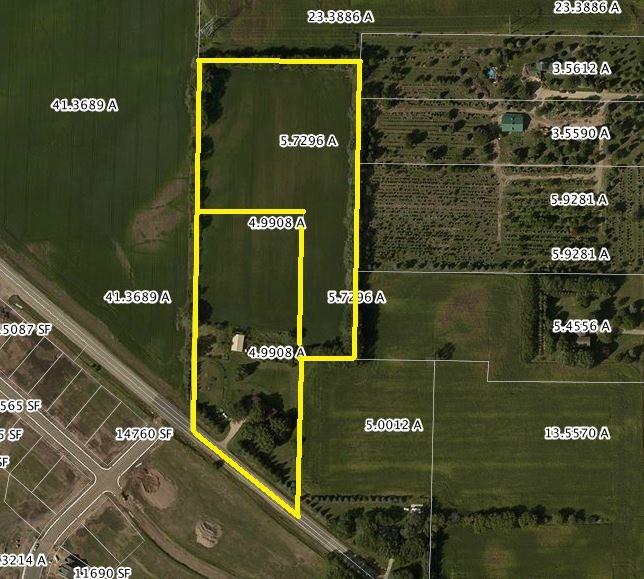
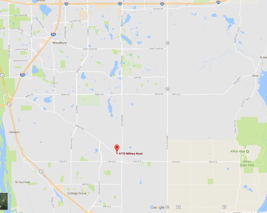
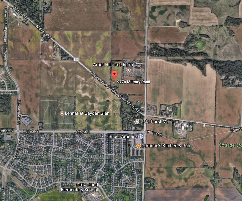
2 PROPERTY INFORMATION LIST PRICE: $825,000 PROPERTY TYPE: Development Land - Residential land or Mixed Use Development may be possible. City of Cottage Grove is very open to development concepts. Bring your ideas! TOTAL ACREAGE 2 PARCELS: Acres PID #: : 5.72 Acres PID #: : 4.99 Acres TOTAL LOT SIZE 2 PARCELS: 466,980 SF PID #: : 217,399 SF PID #: : 249,581 SF PRICE PER SQUARE FOOT: $1.77/SF PRICE PER ACRE: $76,959/ACRE 2 PID NUMBERS: COUNTY: Washington 2017 PROPERTY TAXES FOR BOTH PARCELS: $5,794 Neighboring Parcel: For sale by us Military with 5 acres. See page 3 in this packet for more info. CURRENT ZONING: AG-1 Agricultural Preservation District. This will change when developed. There is currently a residential home on the site that will be demolished with development. This house has a well and septic currently. Water and sewer are now available. TRAFFIC: 2,050 VPD on Military Road UTILITIES: All are accessible. See map in packet showing utility locations. LOCATION: Just off Woodbury Dr/Keats/Hwy 19 and Military Road REPORTS AVAILABLE: 1. ALTA Survey: Available 2. GeoTechnical Report: None 3. Wetland Delineation: Available (Confirmed there are no wetlands on site) 4. Tree Count Survey: Available PROPERTY INFORMATION: Acres available and prime for a Residential or Mixed-Use Development possibly. City envisions Medium to High Density. City Planners are very open to development concepts. Bring your ideas! Medium to High Density. Neighboring parcel at 9880 Military Rd (5 Acres) also for sale by us. Up to 34 Acres may be available with 2 neighboring parcels. Current home on site that was previously rented out, but will be demolished for development. In Spring 2018 the Upper Ravine Parkway Plan construction will begin. This will change Military road and will eventually create a new Future Community Park to the immediate north of the site (see pg 7 in packet and accompanying PDF documents). This project includes bike and walking paths for the local neighborhoods via disconnecting a portion of Military Road. Access to the site will come from the North- see plans in packet. Utilities are all very accessible see plans in packet. Sellers are motivated & will review all offers.

")
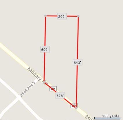
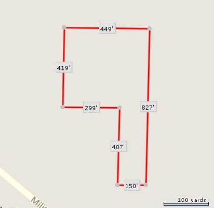
3 REALIST: Tax Parcel Outlines Parcel 1) Parcel: Parcel 2)

4 Other Current For Sale Options - Contiguous Space Neighboring Parcel: 9880 Military Road, Cottage Grove 9880 Parcel: 5 Acres. Total Land Available with 9770 & 9880 Military Rd: Acres Property Website: Marketing Packet: Cottage-Grove_MARKETING-PACKET.pdf?67b1f7 Corner Parcel shown on above map is also available for sale. Contact us for more details. Total land available: ~34 Acres

5 FOR SALE: LAND
6


7 Upper Ravine Park Plan (PDF available)


8 FOR SALE: LAND Project Layout - Jamaica Avenue to Keats Avenue (PDF available)
")
9 Utilities - Military Road (PDF available)
10 Survey - Military Road (Full ALTA Survey available as PDF)
11


12 ZONING: COTTAGE GROVE Current: AG-1 Agricultural Preservation District. Zoning will Change for Development AG-1 Agricultural Preservation District This District is established for those areas where it is necessary and desirable because of the high quality of the soils, availability of water and/or highly productive agricultural capability to preserve, promote, maintain and enhance the use of the land for longterm agricultural purposes, and to protect such land form encroachment by the premature conversion to nonagricultural uses. This District represents areas where services required for urban development will not be available within at least ten (10) years. ZONING: COTTAGE GROVE Future: Medium-High Density Residential

13 TRAFFIC COUNT: 2,050 VPD on Military Road
14
15


, Historic William W.")
16 City of Cottage Grove The city is linked by U.S. Highways 10 and 61 and has a comfortable commute to both downtowns and the I-494 Strip in Bloomington. Once a rural township known for the state's first creameries and wheat production, the area was served by rail lines, river shipping, and grist mills. 3M has been operating a production in facility Cottage Grove since The city has more land adjacent to the Mississippi River than any other city in Minnesota. The city is also bordered by Woodbury on the north, Hastings on the south, St. Paul Park on the west and Denmark Township on the east. The city is approximately half an hour at posted speeds from the Minneapolis-St. Paul International Airport. It is about 15 minutes from the Wisconsin border. The city has a business park with over 25 businesses located on the southwest part of town. Cottage Grove's annual Strawberry Fest draws thousands of residents together to celebrate. This event is held at Kingston Park usually in the second week of June. A parade occurs the Saturday of the festival, in which many organizations or businesses can have a float, throw out candy, and advertise their organization. Historic places include Historic Cedarhurst Mansion, Schilling Archeological District, Atkinson Cemetery, Cottage Grove Town Hall, Old People's Home of the Northwest Cemetery, Grey Cloud Lime Kiln, Historic John P. Furber House, Historic Dr. Arthur H. Steen House, Historic First Congregational Church (Accacia Lodge No. 51), Historic William W. Furber House, Cottage Grove Cemetery, Historic Harry Roberts House, Lamar Avenue Larch Trees, and Hope Glen Farm. Cottage Grove has an 18-hole disc golf course located at Oak Wood Park. The course contains a variety of different length holes and also has women's tees, so it is perfect for people of all skill and age types.
17 OFFERED EXCLUSIVELY BY MARK HULSEY Managing Broker mobile office HAYDEN HULSEY Commercial Broker mobile office No warranty or representation, express or implied, is made as to the accuracy of the information contained herein, and same is submitted subject to errors omissions, change of price, rental or other conditions, withdrawal without notice, and to any specific listing conditions, imposed by RE/MAX Results - Commercial Group.
Micco Park Village Development
 FOR SALE Call For Pricing Micco Park Village Development Proposed Project Property Details Micco Park Village Development PRICE Call For Pricing A monumental development opportunity of a lifetime! The
BUILDER LOTS FOR SALE
 BUILDER LOTS FOR SALE NORTHERN CULPEPER - 135 ACRES RESIDENTIAL DEVELOPMENT 1256 Old Bridge Road, Amissville, VA 20106 SALE PRICE: $995,000 LOT SIZE: 135+ Acres APN #: Tax Map 2 Parcel 23 ZONING: R-1 ACCESS:
GIBRALTAR INVESTMENT PROPERTY SOLUTIONS
 GIBRALTAR INVESTMENT PROPERTY SOLUTIONS Restaurant/Retail Space 270 Eastlake Ave le For more information please contact: Laura Miller (206) 35.3573 MOBILE laura@gibraltarusa.com Gibraltar LLC 206.367.6087
Retail-Office Space For Lease
 Retail-Office Space For Lease 200-204 North Fifth Street, Mebane, NC Pedro J. Carreño Infinito Real Estate Group, L.L.C. pc@infinitoresources.com P.O. Box 2366 Chapel Hill, NC 27515 Tel: 516-967-5294 Infinitorealestate.com
$1,000 Signing Bonus For Leases Executed by the End of 2016
 CLASS A OFFICE SPACE $1,000 Signing Bonus For Leases Executed by the End of 2016 Property Highlights Lease Rate Range Suite # 200 $15.00/SF FSEJ 4,469 SF Sublease with negotiable term Lot Size 1.104 Acres
498 E. Bellevue Avenue Reading, PA 19601
 Hwy Commercial Building For more information: Tammy K. Mitgang 610 370 8514 tmitgang@ John Buccinno 610 370 8508 jbuccinno@ 498 E. Bellevue Avenue Reading, PA 19601 Property Features 5,607 SF Two-story
PRELIMINARY REPORT. HIGHWAY 18 CORRIDOR NEIGHBORHOOD PLAN VILLAGE OF DOUSMAN November, 2014
 PRELIMINARY REPORT HIGHWAY 18 CORRIDOR NEIGHBORHOOD PLAN VILLAGE OF DOUSMAN November, 2014 This preliminary report presents the initial recommendations for land use within the Highway 18 corridor along
COMMISSION ACTION FORM
 ITEM #: 6 DATE: 10-18-17 COMMISSION ACTION FORM REQUEST: Public Hearing on Proposed Amendments to the Ames Urban Fringe Future Land Map and Land Use Policy Plan for the North Growth Gap Area BACKGROUND
FOR SALE Bannister /- Acres Residential/Multifamily Urban Infill
 FOR SALE Bannister -- 32.0 +/- Acres Residential/Multifamily Urban Infill Anticipate 15,000 new employees! Adjacent to huge Bannister Urban Redevelopment area, near Cerner Innovation Campus, Oxford on
LAND PARK COMMUNITY PLAN
 LAND PARK Community Plan Part Three : COMMUNITY PLAN AREAS AND SPECIAL STUDY AREAS SACRAMENTO 2030 GENERAL PLAN Contents Community Location...3-LP-3 Community Vision...3-LP-4 Community Profile...3-LP-4
Major Subdivision Sketch Plan Checklist
 This checklist provides specific requirements that are apart of the Sketch process. The entire process is described by the Huntersville Subdivision Review Process which details all the submittal and resubmittal
Planning Districts INTRODUCTION
 INTRODUCTION To facilitate detailed examination of development prospects for all areas of the community, Delano has been divided into 14 planning districts. The location of these planning districts is
TEN MILE & FRANKLIN LAND 39± ACRES 2954 WEST FRANKLIN ROAD MERIDIAN, ID
 PROPERTY INMATION HIGHLIGHTS Property Type: Land»» Access points: Three commercial access points on Ten Mile Land Size: 38.99 Acres Parcel: S1211336065 Zoning: RUT: Rural Urban Transition Future Zoning:
Grand Rounds History
 Grand Rounds History 1883 Plan for Minneapolis Park System prepared by Landscape Architect Horace W. S. Cleveland. The system of connecting parks and parkways was first called the Grand Rounds by William
Blue Line LRT Extension
 v e Noble Pkwy Noble Pkwy Xerxes Ave N Shingle Creek Penn Ave N Penn Ave N Fremont Ave N Lyndale Ave N S Washington Ave University Ave NE Blue Line LRT Extension LIGHT RAIL PLATFORM AND STATION DESIGN
2.0 Hi s t o r y & Existing Co n d i t i o n s
 2.0 Hi s t o r y & Existing Co n d i t i o n s 2.1 Plan Area History The Lincoln East Specific Plan (Specific Plan) area is a significant part of the history of Sutter County. A 48,000 acre land grant
FOR SALE OR LEASE ±12,600 SQ. FT. AUTO/TRUCK SERVICE FACILITY
 FOR SALE OR LEASE ±12,600 SQ. FT. AUTO/TRUCK SERVICE FACILITY FOR ADDITIONAL INFORMATION, CONTACT 2 TAYLOR AVENUE CITY OF POUGHKEEPSIE, NY James Martin Senior Vice President Exclusive Broker BUILDING:
Gold Line Bus Rapid Transit Transit Oriented Development (BRTOD) Helmo Station Area Plan
 Helmo Station Area Plan") Appendix F Gold Line Bus Rapid Transit Transit Oriented Development (BRTOD) Helmo Station Area Plan Introduction and Purpose of the Plan The Gold Line Bus Rapid Transit facility is an eleven-mile dedicated
Appendix F Gold Line Bus Rapid Transit Transit Oriented Development (BRTOD) Helmo Station Area Plan Introduction and Purpose of the Plan The Gold Line Bus Rapid Transit facility is an eleven-mile dedicated
SUNSET CORRIDOR LAND. The property is now available and ready for corporate utilization, development or investment.
 SUNSET CORRIDOR LAND The property is now available and ready for corporate utilization, development or investment. This 275-acre site is now available and ready to develop. Just off US 26, this west Sunset
Church Property List Price: $625,000
 List Price: $625,000 Falls Park Christian Center 1404 & 1515 N. North Drive, & 1301 N. 1st Avenue Sioux Falls, SD, 57104 Property Features Building Size: 3,810 sq. ft. Lot Size: 2.77 acres (120,225 sq.
NOTICE OF PREPARATION
 NOTICE OF PREPARATION DATE: January 6, 2016 TO: LEAD AGENCY: Responsible Agencies, Organizations, and Interested Parties Contact: Tyler Barrington, Principal Planner Planning Department Community Development
THE PLANNING AREA 2.1 PLANNING AREA LOCATION
 2. The Planning Area Brisbane Baylands Specific Plan 21 2 THE PLANNING AREA 2.1 PLANNING AREA LOCATION The Baylands is located approximately midway between San Francisco s central business district and
Town of Bethlehem Development Planning Committee (DPC) Agenda Thursday, December, :00 AM Bethlehem Town Hall, Room 101
 Agenda Thursday, December, :00 AM Bethlehem Town Hall, Room 101") David VanLuven Town Supervisor Robert Leslie, AICP Director of Planning TOWN OF BETHLEHEM Albany County - New York ECONOMIC DEVELOPMENT AND PLANNING 445 DELAWARE AVENUE DELMAR, NEW YORK 12054 (518) 439-4955
David VanLuven Town Supervisor Robert Leslie, AICP Director of Planning TOWN OF BETHLEHEM Albany County - New York ECONOMIC DEVELOPMENT AND PLANNING 445 DELAWARE AVENUE DELMAR, NEW YORK 12054 (518) 439-4955
Mitchell Ranch South MPUD Application for Master Planned Unit Development Approval Project Narrative. Introduction
 Mitchell Ranch South MPUD Application for Master Planned Unit Development Approval Project Narrative Introduction Mitchell Ranch South is a proposed single family (detached) residential development on
DEVELOPMENT FRAMEWORK POST 2030 LAND USE PLAN INTRODUCTION
 INTRODUCTION Oak Grove s Comprehensive Plan identifies a future Metropolitan Urban Service Area (MUSA). The Metropolitan Council does not anticipate extending utilities to this area prior to 2030. The
This chapter describes the purpose of the Plan, introduces how the Plan is organized and provides contextual background for the Plan.
 Chapter 1: INTRODUCTION Purpose of a Comprehensive Plan The 2040 Comprehensive Plan establishes Medina s vision as a community and sets goals and objectives which guide future decisions and policies. The
Northwest commuter rail station US 36 BRT. Westminster Station
 Northwest commuter rail station Westminster Station US 36 BRT Westminster Center US 36 & Church Ranch Broomfield Flatiron/96 th St. US 36 & McCaslin Table Mesa Boulder Junction 13-month effort that will
LOS ANGELES CITY PLANNING DEPARTMENT STAFF REPORT
 LOS ANGELES CITY PLANNING DEPARTMENT STAFF REPORT LOS ANGELES CITY PLANNING COMMISSION CASE NO: CPC 2006-9374 CRA CEQA: Exempt DATE: December 21, 2006 Location: Valley Plaza and Laurel Plaza TIME: after
June 14, 2017 for the June 20, 2017 Parks and Trails Commission Meeting
 105 South Fifth Avenue Suite 513 Minneapolis, MN 55401 Tel: 612-252-9070 Fax: 612-252-9077 www.landform.net TO: FROM: DATE: Corcoran Parks and Trails Commission Kendra Lindahl, Landform June 14, 2017 for
DavisParkEast DAVIS PARK EAST, RESEARCH TRIANGLE PARK. FOR SALE > LAND Master Planned Community Multifamily Residential Commercial
 DAVIS PARK EAST, RESEARCH TRIANGLE PARK P FOR SALE > LAND Master Planned Community Multifamily Residential Commercial DavisParkEast Premier Urban Mixed-Use Development Opportunity North View Minutes to
Examples of Asset Based Approaches to Development. Economic and Community Development Suffield, CT
 Examples of Asset Based Approaches to Development Presented by: Patrick McMahon, Director of Economic and Community Development Suffield, CT Neighborhood Commercial Development Wilson, CT Issues Elevated
One of the components of the sustainable, traditional neighborhood is the neighborhood center.
 One of the components of the sustainable, traditional neighborhood is the neighborhood center. The neighborhood center defines a community s identity and is the place for events, leisure activities, public
Planning Commission Staff Report Project Plan Approval Hearing Date: June 14, 2017
 Planning Commission Staff Report Project Plan Approval Hearing Date: June 14, 2017 ITEM 3 Peter Matson requests Project Plan Approval for an 80-acre mixed-use plan that includes 220 residential units and
Procedures IV. V. Rural Road Design Option
 i IV. Procedures A. All applicants required to prepare a Conservation Design Subdivision shall provide the Planning Board with a conceptual conventional subdivision design as well as a proposed layout
CITY OF EAU CLAIRE, WISCONSIN REQUEST FOR PROPOSALS
 CITY OF EAU CLAIRE, WISCONSIN REQUEST FOR PROPOSALS Commercial Development Opportunity 617 South Barstow Street Parcel 02-0071 The City of Eau Claire is seeking proposals for the commercial development
Town of Liberty, NY COMPREHENSIVE PLAN & ZONING UPDATES
 Town of Liberty, NY S Public Informational Meeting October 4, 2016 High School Auditorium Welcome Thank you for coming tonight. Agenda Part I Overview of Proposed Changes What is Being Prepared Anticipated
Riverview Road Fort Washington, MD. 163 Waterfront Street, Suite #450 National Harbor, MD (301)
") Riverview Road Fort Washington, MD 163 Waterfront Street, Suite #450 National Harbor, MD 20745 (301) 750-7040 www.fleurdelisllc.com 1 Prepared by Monique Anderson Walker Principal +1 301-750-7040 Monique@FleurDeLisLLC.com
Riverview Road Fort Washington, MD 163 Waterfront Street, Suite #450 National Harbor, MD 20745 (301) 750-7040 www.fleurdelisllc.com 1 Prepared by Monique Anderson Walker Principal +1 301-750-7040 Monique@FleurDeLisLLC.com
APPENDIX 4 NEWBURY TOWNSHIP TOWN CENTER MASTER PLAN
 APPENDIX 4 NEWBURY TOWNSHIP TOWN CENTER MASTER PLAN Prepared by the Urban Design Center of Northeast Ohio September, 2008 Newbury Township Land Use Plan A4-1 INDEX Page No. 1 Newbury Township Town Center
Developer s Program. The Station at East 54
 Developer s Program The Station at East 54 Existing Conditions The Station at East 54 is proposed for a 1.12 acre site at the northeast corner of Hamilton Road and Prestwick Road, tucked between the East
Sam Furr and McCord Road Huntersville, North Carolina
 108± Acres of Sam Furr and McCord Road Huntersville, North Carolina NorthCross Shopping Center Land for Sale 108 Acres located in northeast Huntersville wth extensive frontage along both Sam Furr Road
CHAPTER 4 FUTURE LAND USE AND URBAN SERVICES DISTRICTS
 CHAPTER 4 FUTURE LAND USE AND URBAN SERVICES DISTRICTS Introduction This chapter discusses how Benzie County should grow and change in the future. A community can grow and change in many different ways.
CARY BALLET CONSERVATORY NW CARY PARKWAY CARY, NC TradeMark Properties
 CARY BALLET CONSERVATORY 3791 NW CARY PARKWAY CARY, NC 27513 3971 NW Cary Parkway was designed and constructed for the use as a world-class premier ballet studio in 1999. The 1.89-acre site was specifically
COMMISSION ACTION FORM
 ITEM #: 6 DATE: 09-06-17 COMMISSION ACTION FORM REQUEST: Introduction and Initial Review of Proposed Amendments to the Ames Urban Fringe Future Land Map for the North Growth Gap Area BACKGROUND INFORMATION:
Rezoning Petition Pre-Hearing Staff Analysis July 16, 2018
 Rezoning Petition 2018-044 Pre-Hearing Staff Analysis July 16, 2018 REQUEST Current Zoning: R-3 (single family residential) Proposed Zoning: UR-2(CD) (urban residential, conditional) LOCATION Approximately
Appendix E. Development Concepts
 Appendix E The following analyses examine alternative land use concepts by listing the different advantages and disadvantages of each. The alternatives are graphically presented on the Development Concept
DEVELOPMENT FRAMEWORK 2030 LAND USE PLAN INTRODUCTION
 INTRODUCTION The Oak Grove Land Use Plan anticipates two stages of community development. The first stage of development (28-23) promotes very low density rural growth patterns characterized by large lots,
PROJECT BACKGROUND. Preliminary Design Scope and Tasks
 PROJECT BACKGROUND Preliminary Design Scope and Tasks The purpose of this Study is the development of preliminary designs for intersection improvements for Trunk Highway (TH) 36 at the intersections of
DavisParkEast DAVIS PARK EAST, RESEARCH TRIANGLE PARK. FOR SALE > LAND Master Planned Community Multifamily Residential Commercial
 DAVIS PARK EAST, RESEARCH TRIANGLE PARK P FOR SALE > LAND Master Planned Community Multifamily Residential Commercial Davis Drive DavisParkEast Premier Urban Mixed-Use Development Opportunity North View
EXHIBIT 5-1 VILLAGE OF WILD ROSE FUNCTIONAL CLASS AND AVERAGE DAILY TRAFFIC VOLUMES 2000 & 2003 DATA
 3400 3600 EXHIBIT 5-1 FUNCTIONAL CLASS AND AVERAGE DAILY TRAFFIC VOLUMES 2000 & 2003 DATA Rural Minor Arterial Rural Major Collector Rural Minor Collector Rural Local 2000 Traffic Count 2003 Traffic Count
Municipal Plan*Assessment
 Municipal Plan*Assessment This tool was developed to assist in reviewing municipal master plans and in determining if these plans are consistent with smart growth principles, neighboring municipal plans,
Windsor Locks Transit-Oriented Development Planning Grant Request. Project Background
 Windsor Locks Transit-Oriented Development Planning Grant Request Project Background Downtown Windsor Locks runs along Main Street in the vicinity of the intersection of Routes 159 and 140. The current
Main Street, Boise, Idaho 83702
 906-90 Main Street, Boise, Idaho 870 FIRST, SECOND & THIRD FLOOR SPACES Property Highlights Listing Features st Fl Retail/Office Estimated NNN Office - Ste 00 Office - Ste 0 Office - Ste Office - Ste 5
LAND USE PLAN. Introduction
 LAND USE PLAN Introduction The City of Lake Elmo is a unique gem within the metropolitan region given its overall rural character, significant natural resources and abundance of agricultural lands. The
1.0 INTRODUCTION 1.1 TH 14 WEST STUDY AREA Project Description Functional Classification Purpose of the Project
 1.0 INTRODUCTION 1.1 TH 14 WEST STUDY AREA 1.1.1 Project Description The Trunk Highway (TH) 14 West Corridor is a two-lane roadway approximately 22 miles in length. Located in Nicollet County, the corridor
Peppertree Business Park
 12.55 Net Acres Corporate/Institution Development Site PEPPERTREE BUSINESS PARK IS A UNIQUELY BEAUTIFUL MASTER PLANNED DEVELOPMENT SITE NESTLED AT THE FOOT OF THE SIMI HILLS WITH MEIER CREEK STREAMBED
PARHAM & QUIOCCASIN ROADS HENRICO (RICHMOND), VA
, VA") PARHAM & QUIOCCASIN ROADS HENRICO (RICHMOND), VA THE FUTURE OF REGENCY: Endless Possibilities MALL INFORMATION Location Market Description Anchors Zoning B-3 1.5 miles south of I-64 at exit 181 in Richmond,
PARHAM & QUIOCCASIN ROADS HENRICO (RICHMOND), VA THE FUTURE OF REGENCY: Endless Possibilities MALL INFORMATION Location Market Description Anchors Zoning B-3 1.5 miles south of I-64 at exit 181 in Richmond,
ALBEMARLE COUNTY CODE CHAPTER 18 ZONING SECTION 20A NEIGHBORHOOD MODEL - NMD
 CHAPTER 18 ZONING SECTION 20A NEIGHBORHOOD MODEL - NMD Sections: 20A.1 PURPOSE AND INTENT 20A.2 STATUS AS A PLANNED DEVELOPMENT DISTRICT 20A.5 CODES OF DEVELOPMENT 20A.6 PERMITTED USES 20A.7 RESIDENTIAL
COLVER ROAD INDUSTRIAL CONCEPT PLAN
 COLVER ROAD INDUSTRIAL CONCEPT PLAN A CONCEPTUAL LAND USE AND TRANSPORTATION PLAN FOR TA-4 AN URBAN RESERVE AREA OF THE CITY TALENT City of Talent Adopted by City Council Resolution No., June, 2015 PART
495/MetroWest Development Compact Plan Citizen Planner Training Collaborative Conference. March 17, 2012
 495/MetroWest Development Compact Plan Citizen Planner Training Collaborative Conference March 17, 2012 Project Process Local and Regional Priority Areas Growth Scenarios Transportation Investment Categories
Senator Sieben SF Representative Schoen HF Presentation Guide
 Senator Sieben SF 1179 Representative Schoen HF 1374 Presentation Guide Appearance Transportation and Public Safety, Room 15 of the Capitol. 3-5:30 PM on Wednesday, March 13 Speakers Honorable Senator
CHAPTER 4 - LAND USE CLASSIFICATIONS
 CHAPTER 4 - LAND USE CLASSIFICATIONS Four new land use classification categories are established in the Gualala Town Plan: Gualala Village Mixed Use; Gualala Highway Mixed Use; Gualala Planned Development
S o u t h C e n t r a l O u t l i n e P l a n. Leduc Business Park. North Leduc Industrial Area Structure Plan C it y of Led u c.
 Leduc Business Park North Leduc Industrial Area Structure Plan C it y of Led u c Prepared for Farm Air Properties Inc. January, 2007 Table of Contents Page Number 1.0 Purpose of Plan and Definition of
WORK SESSION STAFF REPORT Work Session Item No. 2. Michael Grochala, Community Development Director
 WORK SESSION STAFF REPORT Work Session Item No. 2 WS Item 2 Date: March, 2018 To: From: Re: City Council Michael Grochala, Community Development Director 200 Comprehensive Plan Mixed Use Districts Background
General Location Annex, Rezone & Preliminary Plat Lansdowne Addition, Unit Three
 NEWFOUNDLAND I-5 Agricultural District Subject Site SUNDANCE ANDERSON Single Family Residential CHRISTY PUD Agricultural District Highway Business General Location Annex, Rezone & Preliminary Plat Lansdowne
Sanford/Lee County Technical Review Committee (TRC) DEADLINES & MEETING DATES
 DEADLINES & MEETING DATES") Sanford/Lee County Technical Review Committee (TRC) DEADLINES & MEETING DATES The following 2019 information is based on the information available to staff at the time of creation. Dates & time may change
Sanford/Lee County Technical Review Committee (TRC) DEADLINES & MEETING DATES The following 2019 information is based on the information available to staff at the time of creation. Dates & time may change
Rezoning Petition Post-Hearing Staff Analysis July 31, 2018
 Rezoning Petition 2018-044 Post-Hearing Staff Analysis July 31, 2018 REQUEST Current Zoning: R-3 (single family residential) Proposed Zoning: UR-2(CD) (urban residential, conditional) LOCATION Approximately
Embrace Green Urban Space:
 1 Embrace Green Urban Space: Parks/Green Space as Vital to Urban Livability Jenna Fletcher The Trust for Public Land LUAC November 15, 2012 2 The Trust for Public Land conserves land for people to enjoy
Corridor Background. Defining the Corridor Study Area. Lake Street. 38th Street. 46th Street
 1 Corridor Background Defining the Corridor Study Area Minnehaha Avenue (CSAH 48) and Hiawatha Avenue (MN 55) are parallel diagonal roadways, approximately three blocks apart, that provide two direct arterial
CHAPTER 7: VISION AND ACTION STATEMENTS. Noble 2025 Vision Statement
 CHAPTER 7: VISION AND ACTION STATEMENTS This chapter presents the vision, policy and action statements that transform the comprehensive planning study, an analysis of Noble s past, future trends and community
The Maryland-National Capital Park and Planning Commission Prince George's County Planning Department Development Review Division
 The Maryland-National Capital Park and Planning Commission Prince George's County Planning Department Development Review Division 301-952-3530 Note: Staff reports can be accessed at www.mncppc.org/pgco/planning/plan.htm.
2030 Comprehensive Plan VISION STATEMENT
 RESOURCE DOCUMENT for Steering Committee Meeting #2 July 12, 2017 2030 Comprehensive Plan VISION STATEMENT Steering Committee from 2008 Established the Lauderdale s Vision as: Creating a livable, lovable
109 Wood Creek Drive. Kim Gore, Broker
 109 Wood Creek Drive Features: 3 Bedrooms, 2.5 Baths 2.952 Sq. Ft. Custom built home, located in Golf Course Community. Alderwood trim & cabinetry Wrought iron embellished front door Beautifully laid out
Wildflowers grow in the new community park on Oakwood Road
 Wildflowers grow in the new community park on Oakwood Road PLANNING AREA - NEW PARKS An important element in the plan for the City of Delafield is to look ahead for future park needs. The City has the
LAND USE MODEL UPDATE. Planning and Land Use Advisory Committee Meeting #2 September 4, 2014
 1 LAND USE MODEL UPDATE Planning and Land Use Advisory Committee Meeting #2 September 4, 2014 2 Presentation Outline Introduction and Recap Model Process Study Design Place Types Suitability Factors 3
Lindsey Self Storage Group
 EXCLUSIVE OFFERING from Lindsey Self Storage Group Glade Self Storage 4106 US-29, Greensboro, NC 27405 Co-Founded by Alan and John Lindsey, Lindsey Self Storage Group s only focus is self-storage brokerage.
CITY OF NORCROSS LILLIAN WEBB PARK REDEVELOPMENT AREAS
 7/2/2016 CITY OF NORCROSS LILLIAN WEBB PARK REDEVELOPMENT AREAS 2016 Potential Development Around Lillian Webb Park The Lillian Webb Park Development Project is located north of Buford Highway; east of
Tri-County Transportation & Land Use Study. Steering Committee Meeting May 14, 2009
 Tri-County Transportation & Land Use Study Steering Committee Meeting May 14, 2009 Agenda Recap of Study Goals and Objectives Update on CV Land Use Model: Business as Usual (BAU) Growth Scenario Pros vs
REQUEST FOR COUNCIL ACTION 6A AGENDA ITEM ORIGINATING DEPT. AGENDA ITEM CITY ADMINISTRATOR APPROVAL
 DATE REQUEST FOR COUNCIL ACTION 6A AGENDA ITEM ORIGINATING DEPT. AGENDA ITEM CITY ADMINISTRATOR APPROVAL Community Development Territorial Greens PUD Concept Plan Development Stage Plan Subdivision (Preliminary
DESCRIPTION AS FURNISHED: THE WEST 3/4 OF THE WEST 1/2 OF THE NORTHWEST 1/4 OF SECTION 7, TOWNSHIP 25 SOUTH, RANGE 21 EAST, PASCO COUNTY, FLORIDA.
 PROJECT VICINITY MAP VILLAGES OF PASADENA HILLS VILLAGE C PARCEL "C-" MPUD Zoning Plan Owner: 66 Beachland Blvd. Suite 3 Vero Beach, FL 32963 PHONE: (772) 4-24 FAX: (772) 4-369 Attn: CRAIG LINTON Legal
The Legacy Project Former Hardee s Headquarters N. Church Street Rocky Mount, NC. Offered for Lease or Sale
 Offered for Lease or Sale The Legacy Project Former Hardee s Headquarters 1405-1625 N. Church Street Rocky Mount, NC For more information, contact: Steve Stroud, SIOR NAI Carolantic Realty, Inc. Robin
Property Description History Regional Orientation Local Context Existing Assets Analysis Of Developable Areas...
 Appendix: Site Background and Analysis Property Description.... 48 History.... 48 Regional Orientation... 49 Local Context... 52 Existing Assets... 53 Analysis Of Developable Areas... 64 Aggregate Resources....
Maryland Historical Trust Inventory No. PG: 85B-007 Maryland Inventory of Historic Properties Form
 Maryland Historical Trust Inventory No. PG: 85B-007 Maryland Inventory of 1. Name of Property (indicate preferred name) historic other 2. Location street and number Cedarville State Forest Road, Cedarville
August 2016 COTTAGE GROVE STATION AREA PLANNING REPORT
 August 2016 COTTAGE GROVE STATION AREA PLANNING REPORT Introduction The Red Rock Corridor is a proposed 30 mile transitway that runs along Highway 61 and Interstate 94 between Hastings and Union Depot
Planned Development (PD) B0, C0 Deed Reference: Valley Township and West Caln Township
 B0, C0 Deed Reference: Valley Township and West Caln Township") For Sale 717.293.4477 Industrial Land for Sale Industrial/Commercial Realtors Phase II Industrial Land Highlands Corporate Center Highlands Boulevard Lots #36, #37, #38, #39 Coatesville, PA 19320 Available
For Sale 717.293.4477 Industrial Land for Sale Industrial/Commercial Realtors Phase II Industrial Land Highlands Corporate Center Highlands Boulevard Lots #36, #37, #38, #39 Coatesville, PA 19320 Available
PART 1: PROJECT SUMMARY. The application is Attachment A. The site plan is Attachment B.
 Belleterre Subdivision Sketch Plan Town Board 8.7.17 Belleterre Subdivision Sketch Plan PART 1: PROJECT SUMMARY Applicant: Bowman Development Project Size: +/- 20.85 acres Parcel Number: 01115104 and 01115121
PLANNED UNIT DEVELOPMENT & SUBDIVISION STAFF REPORT Date: May 18, 2017
 & PUD-0000102-2017 PLANNED UNIT DEVELOPMENT & SUBDIVISION STAFF REPORT Date: May 18, 2017 NAME SUBDIVISION NAME Dauphin Creek Estates Subdivision Dauphin Creek Estates Subdivision LOCATION CITY COUNCIL
PLANNED UNIT DEVELOPMENT Date: April 5, 2018
 PLANNED UNIT DEVELOPMENT Date: April 5, 2018 DEVELOPMENT NAME SUBDIVISION NAME LOCATION Robert Myers Robert Myers 2955 and 2989 Dauphin Street (Southeast corner of Dauphin Street and Sage Avenue) CITY
Denmark Township 2030 Comprehensive Plan and Mississippi River Critical Area Plan
 Denmark Township and Mississippi River Critical Area Plan Adoption date: April 6, 2009 Updated Adoption date: October 3, 2011 Denmark Township, Minnesota TKDA Project No. 13964.000 Acknowledgements Thanks
Sewanee Village + Request for Builder/Developer Proposals
 Sewanee Village + Request for Builder/Developer Proposals Contact: Frank X. Gladu Special Assistant to the Vice Chancellor University of the South 735 University Ave Version 3 Sewanee TN 37383 Released:
Elm Fork Land Use. Trinity River Corridor Project Committee May 13, 2013
 Elm Fork Land Use Trinity River Corridor Project Committee May 13, 2013 Purpose Discuss Trinity River planned Land Use and Appropriate Compatible Uses, particularly with respect to the Elm Fork Area 2
Edmond Plan IV Update 2016, Descriptions and Recommendations for future Land Use for the Far Northeast Neighborhoods.
 TO: FROM: Edmond Planning Commission Robert L. Schiermeyer, City Planner DATE: October 2016 RE: Edmond Plan IV Update 2016, Descriptions and Recommendations for future Land Use for the Far Northeast Neighborhoods.
Secrest Short Cut and Monroe Expressway Small Area Plan AUGUST 29, 2018
 Secrest Short Cut and Monroe Expressway Small Area Plan AUGUST 29, 2018 Background and Process Monroe Expressway will be open by the end of 2018 Union County and Indian Trail identified a need to revisit
Albert Lea. Redevelopment Plan. 701 Xenia Avenue South, Suite 300 Minneapolis, MN Tel: (763) Fax: (763) wsbeng.
 Fax: (763) wsbeng.") Albert Lea Redevelopment Plan 701 Xenia Avenue South, Suite 300 Minneapolis, MN 55416 Tel: (763) 541-4800 Fax: (763) 541-1700 wsbeng.com Albert Lea Redevelopment Plan Table of Contents Composite Districts...
Albert Lea Redevelopment Plan 701 Xenia Avenue South, Suite 300 Minneapolis, MN 55416 Tel: (763) 541-4800 Fax: (763) 541-1700 wsbeng.com Albert Lea Redevelopment Plan Table of Contents Composite Districts...
REQUEST FOR PROPOSAL
 REQUEST FOR PROPOSAL The City of Poughkeepsie seeks qualified not for profit organizations interested in leasing property located at 36 North Clover Street in the City of Poughkeepsie for the purpose of
EXPANDED ENVIRONMENTAL ASSESSMENT FORM PART III Bear Mountain Triangle Rezoning
 EXPANDED ENVIRONMENTAL ASSESSMENT FORM PART III Bear Mountain Triangle Rezoning Town of Yorktown, NY Introduction The Environmental Assessment Form (EAF) examines the environmental implications of the
10 Year Family Dollar NNN Lease - Rare Urban location
 505-4 0 1-0 1 3 5 O w n e r / B r o k e r 505-6 1 0-1 6 5 5 O w n e r / B r o k e r 10 Year Family Dollar NNN Lease - Rare Urban location A c t u a l P r o p e r t y P h o t o Sale Price: $2,000,000 NOI:
CITY OF ZEELAND PLANNING COMMISSION
 APPLICATION FOR SITE PLAN REVIEW AND SPECIAL LAND USE Date City Official App. Filing Fee Rec'd ($350) NOTE TO APPLICANT: Please submit this application for Site Plan Review along with twenty (20) copies
Asbury Chapel Subdivision Sketch Plan
 Asbury Chapel Subdivision Sketch Plan PART 1: PROJECT SUMMARY Applicant: NVR Inc. Project Size: +/- 76.13 acres Parcel Numbers: 02101112,02116101,02116112, 02116113 Current Zoning: Transitional Residential
THE ASHLAND OVERVIEW. FXCollaborative SPAN Architecture WSP USA ICOR Associates Site/Civil Geotechnical Environmental Surveying/Geospatial
 LEADER DRAFT THE ASHLAND Brooklyn NY Gotham FXCollaborative SPAN Architecture Partner: WSP USA ICOR Associates Site/Civil Geotechnical Environmental Surveying/Geospatial The Ashland is a 52-story 586-unit
Master Environmental Servicing Plan & Secondary Plan
 1 East Side Lands Stage 2 Master Environmental Servicing Plan & Secondary Plan Public Consultation Centre #4 March 20, 2018 Welcome! Today s Agenda Please sign in at the registration table. 6:00 pm 6:30