Wildflowers grow in the new community park on Oakwood Road
|
|
|
- Darcy Collins
- 5 years ago
- Views:
Transcription

1 Wildflowers grow in the new community park on Oakwood Road PLANNING AREA - NEW PARKS An important element in the plan for the City of Delafield is to look ahead for future park needs. The City has the opportunity to develop an existing 39 acre parcel, located on the Northwest corner of Oakwood Road and Highway 83, referred to as Oakwood Community Park; an 8 acre parcel and a 4 acre parcel adjacent to St. Joan of Arc, in the Northwest Quadrant, referred to as the Knoff-Binkowski parcel; and a proposed 9 acre parcel along the Bark River Conservancy Corridor, located northwest of Wee Know Preschool on the west side of Highway 83, referred to as the proposed Northeast Quadrant parcel. Park and Recreation 5 year plan Page 48
, the Bark River, and the downtown. The land is also adjacent to SJNMA, and a large city parking lot that is used as festival and event space for the city.")
, and proposed location of the park (outlined in blue) are below.")
2 Liberty Park has the potential to be a center piece for civic activity LIBERTY PARK EXPAND THE EVENT SPACE ALONG THE BARK RIVER The City owns land adjacent to the Veterans Memorial Riverwalk (VMR), the Bark River, and the downtown. The land is also adjacent to SJNMA, and a large city parking lot that is used as festival and event space for the city. While not replacing the event space, this park will complement it. The proposed name of this park is Liberty Park. A map of the parking lot (circled in red), and proposed location of the park (outlined in blue) are below. The boundaries of the lot are noted in the aerial photo below with boundaries show in red. Park and Recreation 5 year plan Page 49


3 The park has a natural connection to the Veterans Memorial River Walk (VMR), St. John s Northwestern military Academy, and the bridge that connects the parcel to the municipal parking lot. The goals for the park are: Honoring Veterans Destination for the VMR Expands space for city events Simple outdoor stage for concerts and presentations Complements proposed SJNMA fine arts center. Path around park with benches Open space Performing arts space Park and Recreation 5 year plan Page 50


4 CURRENT CONDITION Overhead view of the parcel of land to be designated as Liberty Park. The property is owned by the City of Delafield. It is adjacent to St. Johns Northwestern Military Academy to the North and West of the property. The proposed park is bordered by the Bark River to the south. The Veterans Memorial River Walk follows the course of the river on the south side of the park adjacent to the river. The area of the park was once a fish hatchery pond. It is located in a flood plain. Park and Recreation 5 year plan Page 51


5 PHOTOS OF THE PROPOSED PARK IN ITS PRESENT STATE. View of the park facing southeast from a small hill on the property. View of the park from the west side of the park looking east. View of River from the bridge Main space of park Park and Recreation 5 year plan Page 52
 would be extended to circle the park (orange line). The majority of the park would be planted with grass.")
6 THE CONCEPTUAL DESIGN While design work will need to be completed for the site, an example concept for the park is illustrated below. The VMR path (blue line) would be extended to circle the park (orange line). The majority of the park would be planted with grass. A simple stage that has electrical service would be at the south end of the park (light blue rectangle). A Veterans memorial would be on the West side of the park on the top of the small hill (dark blue polygon). A restroom would be located near parking. The park would be lighted for safety and evening use. Benches, doggy stations, and information signs would be located throughout the park. The pipe over the river would be buried or removed as part of the project. Note: the yellow line is the boundary of the parcel. Park and Recreation 5 year plan Page 53

7 Park and Recreation 5 year plan Page 54


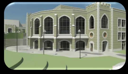
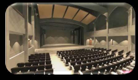
8 ST JOHNS NORTHWESTERN MILITARY ACADEMY FINE ARTS CENTER Directly to the North of the park is a proposed Academic / Fine arts Building. Below are renderings provided by SJNMA which are conceptual. Park and Recreation 5 year plan Page 55
9 REQUIREMENTS AND CONSIDERATIONS TERRAIN AND SURROUNDING AREA Factors and goals for the terrain are: Bark river clean up should be part of the project plan. o Trees have fallen into the river o Pipe crossing the river should be buried or removed o Brush and invasive trees should be removed along the river to create a view of the river from the park Development in the early phases should take place on the East end of the park o St. John s has an arts center proposed near the North West corner of the park, and this will likely lead to changes in the topography when realized. Paths material should be natural, likely crushed limestone Lighting should be installed o Will require electric cabling to be run through the park o Outlets should be available with lighting to facilitate events that will occur in the park Flower beds o Type of flowers should be low maintenance, and are open to further design Benches and bike racks o Should be planned Most of the area of the park should be grass Park and Recreation 5 year plan Page 56


10 STAGE A performance stage will be incorporated in the design, and located at the south end of the park facing north. Electrical power to the stage area should be sufficient to support sound and light systems of significant amperage, and should be three phase electrical service This stage would not replace the need for single use rental stages for large civic events Examples of stages in parks: Park and Recreation 5 year plan Page 57
11 LIBERTY MEMORIAL The memorial will take some time to plan and execute. It is suggested that a panel be set up to decide on the appropriate memorial. This feature would likely be funded by donations. This may be the last element added to the park so that its construction can be coordinated with the SJNMA fine arts building. Funding raising should start immediately. BUDGET 2015 BUDGET Budget Line item and Account Approved Budget Source Planning/Engineering $4,000 General Fund/Bond (100%) Benches, Bike Racks & Signs $7,000 General Fund/Bond (100%) 2016 BUDGET - PROPOSED Budget Line item Budget Source Bury Water Feeder Pipe $65,000 General Fund/Bond (100%) Fountain $40,000 General Fund/Bond (100%) 2017 BUDGET - PROPOSED Budget Line item Budget Source Stage $330,000 Grants (40%), General Fund/Bond (40%), Donations (20%) Veteran s Memorial Grants (30%), General Fund/Bond (20%), Donations (50%) Income from Renting the Stage Revenue Park and Recreation 5 year plan Page 58


12 NW QUADRANT PARCELS The Northwest corner of the City of Delafield should have a community park to serve the recreational needs of the residents at some point in the future. A neighborhood park will be needed to serve the area, and it should be able to be used for both active and passive recreation. The 8 acre neighborhood park parcel adjacent to St. Joan of Arc School will provide a great space to meet these needs. The land is also to be used in conjunction with a smaller 4 acre parcel just to the north. This property is referred to jointly as the Knoff-Binkowski parcel. There are currently no plans for formal development of either parcel. They are both beautiful, natural areas with a variety of wooded and open spaces. The current plan is for the 8 acre parcel to serve as a hub for biking and hiking trails, which will eventually complete a circle around Nagawicka Lake. The smaller 4 acre Knoff parcel will serve as an access easement to the west and allow the City of Delafield to connect recreational trails to points west through Oconomowoc. Both of these parcels provide valuable open spaces and will at some point be ready for development. Future needs will include an interior road to the park and a parking lot, a shelter at the trailhead, and trail development and improvements. Additional phases may include playing fields and play structures. The Park and Rec committee recommended that these amenities, when they are constructed, be provided and maintained by the developer of the adjacent residential area, and be consistent with city standards. Together these parcels give the City of Delafield the ability to connect and expand both existing and future hiking and biking trails. This will be an asset to all of the residents, as Delafield joins surrounding communities who are working together to establish a master plan to connect existing parks and recreational areas throughout the state via a comprehensive trail system. Park and Recreation 5 year plan Page 59

13 NE QUADRANT FUTURE PARCEL The City of Delafield has identified a parcel of land approximately 10 acres located just west of Highway 83 and NW of the Wee Know Preschool. It is located along the Bark River Corridor, and would provide green space and passive park use for residents. This parcel has the potential to add access to the Bark River and connect to the bike path that will eventually circle Nagawicka Lake when it is complete. Park and Recreation 5 year plan Page 60
The following principles guide the development of goals and strategies to protect and promote these amenities:
 OPEN SPACE/PARKS/TRAILS/RECREATION GOALS/STRATEGIES Cherry Hills Village is a living environment that offers low density development, open areas, public scenic vistas, public trails and public parks. This
Chapter 6. Overall Vision RECOMMENDATIONS. More Trail and Trail. Connections. Equal Access to Park. Facilities and Programs. Water Access.
 Overall Vision More Trail and Trail Connections Equal Access to Park Facilities and Programs Water Access Environment Variety Chapter 6 RECOMMENDATIONS Chapter 6 The following recommendations for park,
1. Parks & Recreation Neighborhood Parks Community Parks Special Use Sites 2. Open Space 3. Trails
 Appendix A: Park Classifications The intent of parks and recreation classifications is to aid in making acquisition and design decisions for park sites, facilities and the organization of recreation space
Mendota-Lebanon Hills Greenway Master Plan Executive Summary. August draft for more information visit
 Mendota-Lebanon Hills Greenway Master Plan Executive Summary August 2013 draft for more information visit www.hkgi.com/projects/dakota INTRODUCTION The Mendota-Lebanon Hills Greenway Master Plan portrays
PARTF Scoring System for Grants
 PARTF Scoring System for Grants The members of the N.C. Parks and Recreation Authority use the PARTF scoring system as one of several tools to select grant recipients. Please provide all of the information
PARK & RECREATION. Project Summaries
 PARK & RECREATION Project Summaries 45 BEAVER ISLAND TRAIL EXTENSION - PHASE VIII - 60TH ST S TO CITY LIMITS Project Number: PK.19.01 Construction Year: 2019 quality services to area residents who utilize
4.1.A NORTHWEST QUADRANT MASTER PLAN
 4.1.A NORTHWEST QUADRANT MASTER PLAN (Ordinance 0-16-27, dated October 17, 2016) Goal: Transform the Northwest Quadrant into the cultural centerpiece of Deerfield. Objectives: 1. Maintain the cluster of
Office of Greenways & Trails Providing Statewide Leadership and Coordination. Southeast Greenways and Trails Summit October 1-3, 2017
 Office of Greenways & Trails Providing Statewide Leadership and Coordination Southeast Greenways and Trails Summit October 1-3, 2017 1 Office of Greenways and Trails The Office of Greenways and Trails
DISCUSSION TOPIC: ST JOHNS RIVER & ITS TRIBUTARIES (BPII) 2030 COMPREHENSIVE PLAN POLICES AND REGULATORY FRAMEWORK
 2030 COMPREHENSIVE PLAN POLICES AND REGULATORY FRAMEWORK") DISCUSSION TOPIC: ST JOHNS RIVER & ITS TRIBUTARIES (BPII) 2030 COMPREHENSIVE PLAN POLICES AND REGULATORY FRAMEWORK St. John s River & Its Tributaries Issue Summary: The St. Johns River is an important
DISCUSSION TOPIC: ST JOHNS RIVER & ITS TRIBUTARIES (BPII) 2030 COMPREHENSIVE PLAN POLICES AND REGULATORY FRAMEWORK St. John s River & Its Tributaries Issue Summary: The St. Johns River is an important
Mendota Heights 2040 Comprehensive Plan Draft Vers
 4 Parks and Trails The City of Mendota Heights boasts a variety of recreational and open space opportunities. Few cities can claim access to regional trails, riverside and lakeside parks, scenic bluffs
Yadkin River Greenway Feasibility Study Fact Sheet Village of Clemmons, Town of Lewisville, Town of Bermuda Run
 Fact Sheet Village of Clemmons, Town of Lewisville, Town of Bermuda Run Project Background The Yadkin River Greenway Feasibility Study is a joint project with the Village of Clemmons, the Town of Bermuda
Grand Rounds History
 Grand Rounds History 1883 Plan for Minneapolis Park System prepared by Landscape Architect Horace W. S. Cleveland. The system of connecting parks and parkways was first called the Grand Rounds by William
BURTON STATION STRATEGIC GROWTH AREA PLAN UPDATE PUBLIC MEETING 3/26/18
 BURTON STATION STRATEGIC GROWTH AREA PLAN UPDATE PUBLIC MEETING 3/26/18 1 WHERE WE ARE? 2 PRIMARY OBJECTIVES OF THE PLAN UPDATE 1. Update the land use designation for Burton Station Village to reflect
Goal A- Create a preeminent, professionally based, fi scally sound Department of Parks and Recreation.
 City parks, trails, open spaces, urban forests, and greenways make neighborhoods more attractive places to live, strengthen community pride, offer natural environmental protection, and improve physical
Memo Preliminary. City of Miamisburg Parks Site Reconnaissance
 Memo Preliminary To: From: Ms. Rebecca Benna Woolpert, Inc. Date: Subject: City of Miamisburg Parks Site Reconnaissance The consultant team toured the existing Miamisburg Parks to assess current levels
Mariposa Lakes. Planned Community. Project Overview. Stockton, CA
 Planned Community Stockton, CA Project Overview March 2007 Summary of Proposed Community is a master-planned community proposed for development on approximately 3,810 acres in southeast Stockton. In 2004,
RECREATION, OPEN SPACE AND GREENWAYS ELEMENT GOALS, OBJECTIVES, AND POLICIES
 RECREATION, OPEN SPACE AND GREENWAYS ELEMENT GOALS, OBJECTIVES, AND POLICIES GOAL R-1: DEVELOP A RECREATION, OPEN SPACE AND GREENWAYS SYSTEM AS AN INTEGRAL COMPONENT OF AN OVERALL, COUNTY-WIDE ECONOMIC
CARMODY PARK MASTER PLAN
 the site Smith Reservoir Cottonwood Lake Kendrick Lake Carmody Rec Center Carmody Middle School Pool Court Play Carmody Pond Sanderson Ditch Sports Fields Foothills Ice Arena Open Field why a master plan?
Description of Preferred Alternative
 Chapter 2 Description of Preferred Alternative 2.1 Introduction This chapter of the programmatic Sammamish Town Center Sub-area Plan Final EIS provides a more detailed description of the Preferred Alternative
City of Nogales General Plan
 Open Space, Parks, Recreation and Trails City of Nogales General Plan Residents of Nogales place a high priority in the development of a comprehensive system of open space, parks, recreation and trails
3. VISION AND GOALS. Vision Statement. Goals, Objectives and Policies
 Vision Statement Queen Creek s interconnected network of parks, trails, open spaces and recreation opportunities provide safe and diverse activities and programs that sustain its unique, small town, equestrian
RIDGES TO RIVERS OPEN SPACE NETWORI< OF THE MID-COLUMBIA DRAFT ACTION PLAN
 RIDGES TO RIVERS OPEN SPACE NETWORI< OF THE MID-COLUMBIA DRAFT ACTION PLAN Ridges to Rivers Open Space Network of the Mid-Columbia Region Draft Action Plan (8/6/08) The goals of the propose
TEMPLE MEDICAL & EDUCATION DISTRICT
 City of Temple, Texas TEMPLE MEDICAL & EDUCATION DISTRICT 1 Description. The City of Temple joined in partnership with key public and private entities to jointly promote education and medical activities
CHAPTER 7: VISION AND ACTION STATEMENTS. Noble 2025 Vision Statement
 CHAPTER 7: VISION AND ACTION STATEMENTS This chapter presents the vision, policy and action statements that transform the comprehensive planning study, an analysis of Noble s past, future trends and community
Developer s Program. The Station at East 54
 Developer s Program The Station at East 54 Existing Conditions The Station at East 54 is proposed for a 1.12 acre site at the northeast corner of Hamilton Road and Prestwick Road, tucked between the East
Blue Line LRT Extension
 v e Noble Pkwy Noble Pkwy Xerxes Ave N Shingle Creek Penn Ave N Penn Ave N Fremont Ave N Lyndale Ave N S Washington Ave University Ave NE Blue Line LRT Extension LIGHT RAIL PLATFORM AND STATION DESIGN
Planning Districts INTRODUCTION
 INTRODUCTION To facilitate detailed examination of development prospects for all areas of the community, Delano has been divided into 14 planning districts. The location of these planning districts is
Draft Master Plan for Franklin Park
 Draft Master Plan for Franklin Park Metro Parks Tacoma with SiteWorkshop November 2009 I. overview & background Process & History Master Plan Process The Master Plan is based on a community involvement
DRAFT. Waterfronts and Open Spaces. 10 The Riverfront Open Space System
 CHAPTER 4 Waterfronts and Open Spaces 10 The Riverfront Open Space System 12 Planned, proposed and envisioned riverfront recommendations. Figure 4.3.23 The riverfront will become a major new public amenity
Mississippi Skyway Preliminary Engineering Report
 EXECUTIVE SUMMARY Mississippi Skyway Preliminary Engineering Report CITY OF RAMSEY, MINNESOTA DECEMBER 2014 City of RAMSEY EXECUTIVE SUMMARY Project Need and Intent The Mississippi Skyway pedestrian bridge
DRAFT ROOSEVELT ROAD. District Recommendations. Figure 5.23 The Roosevelt Road Corridor
 CHAPTER 5 Figure 5.23 The Road Corridor Road will develop as a mixed-use corridor, emphasizing regional retail, west of the river and mixed-use development east of the river. KEY RECOMMENDATIONS 1. High
Memorial Park Workshop Notes March 20, :30 10:30am
 Memorial Park Workshop Notes March 20, 2012 7:30 10:30am Black Team Veronica, Jeff, Shelly, Pat, Darcey, Gordy, Jeff Strengths River Size/Space Central Location History River Riffles in River View from/going
A Vision for Walnut Creek
 A Vision for Walnut Creek Photo: City of Clive Walnut Creek Booklet 8 of 8 Greater Des Moines Water Trails and Greenways 1 Table of Contents Booklet 1: Water Trails Strategies and Policies Booklet 2: Beaver
PORT ST. JOE WATERFRONT PARTNERSHIP WATERFRONT STRATEGIC PLAN. Land Design Innovations, Inc.
 Land Design Innovations, Inc. i TABLE OF CONTENTS A. INTRODUCTION..1 B. MASTER PLAN..2 1. Baywalk.. 2 2. St. Joseph s Landings.4 3. Trail Connectors and Improved Pedestrian Crosswalks.5 4. Regional Stormwater
LAND USE PLAN 7. Housing
 21 LAND USE PLAN While the land uses that have historically dominated the Corridor itself have been industrial/commercial, the Master Plan proposes a shift to mixed-use redevelopment, complimented by a
South East Sports Complex Phase I
 South East Sports Complex Phase I City of Spokane Design Review Board August 29, 2018 (Revised) Objectives 1. Early discussion and collaboration. 2. Provide framework / catalyst for future improvements
Chapter 3. Community Vision and Goals
 Chapter 3. Community Vision and Goals 3.1 Public Involvement Charlevoix s master plan was prepared in a way that maximized public participation. Dating back to 2004, the Planning Commission and staff held
Parks, and Recreation & Cultural Arts Master Plan Update
 Parks, and Recreation & Cultural Arts Master Plan Update Community Profile Public Input Summary: Staff Interviews conducted April 14 and 15, 2014 Citizens Workshop - conducted April 15 th and 24 th, May
Corridor Vision. 1Pursue Minnehaha-Hiawatha Community Works Project. Mission of Hennepin County Community Works Program
 1Pursue Minnehaha-Hiawatha Community Works Project Minnehaha-Hiawatha Community Works is a project within the Hennepin Community Works (HCW) program. The mission of the HCW program is to enhance how the
Bourne Downtown Site Planning
 Prepared for: The Town of Bourne, MA In Cooperation with: Bourne Financial Development Corporation Prepared by:, Inc. June 24, 2009 Table of Contents Introduction and Summary... 1 Site Existing Conditions...
Missing Link Study Grand Rounds Parkway Planning and Design Introduction
 Missing Link Study Grand Rounds Parkway Planning and Design Introduction June 19, 2007 Minneapolis Park and Recreation Board HNTB Hoisington Koegler Group Inc. Hess Roise 1 The Missing Link Study The Minneapolis
Planning & Zoning Commission Planning & Development Department February 17, 2014
 Request Applicant Owner Zoning Location Attachments Subdivision of 2.79 acres of currently vacant property to create 27 town home lots and 6 restricted reserves for the use of HOA Parks. John English;
City of Yorba Linda Memorandum
 City of Yorba Linda Memorandum Date: June 15, 2011 Date: To: From: Honorable Chairman and Members of the Parks and Recreation Commission Mike Kudron, Acting Director of Parks and Recreation SUBJECT: BACKGROUND
RIVERFRONT REDEVELOPMENT PLAN
 RIVERFRONT REDEVELOPMENT PLAN PROJECT BACKGROUND DEVELOPMENT OPPORTUNITIES This project strives to connect St. Francisville s downtown Historic District to the Mississippi River through river tourism,
Rosemount Greenway Master Plan Executive Summary. draft. Spring for more information visit
 Rosemount Greenway Master Plan Executive Summary Spring 2012 draft for more information visit www.hkgi.com/projects/dakota INTRODUCTION The Rosemount Greenway Master Plan portrays a vision to establish
Chapter 5: Natural Resources and Environment
 NATURAL RESOURCES AND ENVIRONMENT 5-1 5 Chapter 5: Natural Resources and Environment BACKGROUND AND INTENT Urban expansion represents the greatest risk for the future degradation of existing natural areas,
UPPER BRODHEAD CREEK PARADISE CREEK GREENWAY PLAN
 UPPER BRODHEAD CREEK PARADISE CREEK GREENWAY PLAN The Upper Brodhead & Paradise Creeks Greenway Cooperating Municipalities Mount Pocono Borough Paradise Township Barrett Township Price Township Funding
Draft Stillwater 2030 Comprehensive Plan- Goals and Policies
 Draft Stillwater 2030 Comprehensive Plan- Goals and Policies Instructions- Review each goal and policy and discuss with group any changes, deletions for additions to the list using your groups pen. Keep
RECREATION AND OPEN SPACE ELEMENT GOALS, OBJECTIVES, AND POLICIES
 RECREATION AND OPEN SPACE ELEMENT GOALS, OBJECTIVES, AND POLICIES Goal 7 To provide park facilities, recreation programs, and open space resources that are safe, adequate, and accessible to all City residents,
Southeast Quadrant Plan
 Southeast Quadrant Plan Southeast Quadrant Distinctive Features Land Use The Southeast Quadrant includes all the area within the planning area that is east of Interstate 5 and south of State Route 44.
Provide and maintain sufficient public parks, recreation facilities, and open space to meet the recreational needs of County residents and visitors.
 (ROS) Goal Provide and maintain sufficient public parks, recreation facilities, and open space to meet the recreational needs of County residents and visitors. OBJECTIVE ROS.01 The County shall acquire,
ARISE: The Rock Renaissance Area Redevelopment & Implementation Strategy
 2014 Professional Awards 1 ARISE: The Rock Renaissance Area Redevelopment & Implementation Strategy Janesville, WI Completed December 2014 Analysis & Planning Purpose of Project 2 The purpose of the Rock
M E M O R A N D U M January 6, 2017
 Item #4 M E M O R A N D U M January 6, 2017 To: 2035 Corridor Planning Committee From: Kenneth Baker, Sr. Director of Planning and Development Services Subject: Item #4 Overview Fidelis Purpose: Review
Please read the entire document
 projects impacting the waterfront revitalization area. The waterfront revitalization area of the town will have to subareas to the west and east of the village. Page 6 of 6 Wayfinding master plan create
Stakeholders Advisory Working Groups (SAWGs) Smart Growth and TOD Land Use (#11) SAWG Meeting
 Smart Growth and TOD Land Use (#11) SAWG Meeting") Presentation - Part II Tappan Zee Bridge/I-287 Corridor Project July 21, 2010 Slide 1. David Kooris (Regional Plan Association) welcomed members of the Land Use Stakeholders Advisory Working Groups (SAWGs)
Presentation - Part II Tappan Zee Bridge/I-287 Corridor Project July 21, 2010 Slide 1. David Kooris (Regional Plan Association) welcomed members of the Land Use Stakeholders Advisory Working Groups (SAWGs)
... the real city lives on... Character Area 5: LOWER WASHINGTON
 ... the real city lives on... Character Area 5: LOWER WASHINGTON 89 Boundaries This area is bordered by the extension of Fair Way to the north, the Napa River to the south, Gerard Street/Fire Station parking
This page intentionally blank.
 This page intentionally blank. Parks, Recreation, and Open Space Chapter Relationship to Vision Vision Parks, Recreation and Open Space Chapter Concepts County Government. County government that is accountable
ESTABLISH AN EFFICIENT TOWN CENTER
 ESTABLISH AN EFFICIENT TOWN CENTER 4 Overview Lisbon residents are proud of the history of Newent and at the same time recognize its current importance as a centralized location for a variety of municipal
Riverwalk Dreams compiled by Thomas P. Healy November 16, 2017
 Riverwalk Dreams compiled by Thomas P. Healy November 16, 2017 1986 Ripple Village Plan: A neighborhood plan developed by the City of Indianapolis Department of Metropolitan Development s Division of Planning
Outline Plan in Belvedere (Ward 9) at Street SE, LOC (OP)
 at Street SE, LOC (OP)") 2018 October 04 Page 1 of 12 EXECUTIVE SUMMARY This outline plan application was submitted by B&A Planning Group on 2016 July 15, on behalf of Tristar Communities Inc. for 50.14 hectares (123.89 acres)
2018 October 04 Page 1 of 12 EXECUTIVE SUMMARY This outline plan application was submitted by B&A Planning Group on 2016 July 15, on behalf of Tristar Communities Inc. for 50.14 hectares (123.89 acres)
Trail Feasibility and Planning Project for Northern Dutchess County, New York
 for Northern Dutchess County, New York Funded in Part by Grants from the Hudson River Valley Greenway, Land Trust Alliance Conservation Partnership Program and the Thomas Thompson Trust 1 STEERING COMMITTEE
April 21, 2007 CCRP Workshop Summary
 April 21, 2007 CCRP Workshop Summary Group 1 1. Reuse around BART with a lot of housing and jobs 2. Greenway around creek 3. Transit and auto connection all through the site from Kirker Pass to Port Chicago
Economic Redevelopment of Underutilized Parcels. May 16, 2012 Northland Arboretum Brainerd, Minnesota
 Economic Redevelopment of Underutilized Parcels May 16, 2012 Northland Arboretum Brainerd, Minnesota Matt Glaesman City of St. Cloud Community Development Director 1. A Tradition of Change 2. Why Now?
Elm Fork Land Use. Trinity River Corridor Project Committee May 13, 2013
 Elm Fork Land Use Trinity River Corridor Project Committee May 13, 2013 Purpose Discuss Trinity River planned Land Use and Appropriate Compatible Uses, particularly with respect to the Elm Fork Area 2
Gold Line Bus Rapid Transit Transit Oriented Development (BRTOD) Helmo Station Area Plan
 Helmo Station Area Plan") Appendix F Gold Line Bus Rapid Transit Transit Oriented Development (BRTOD) Helmo Station Area Plan Introduction and Purpose of the Plan The Gold Line Bus Rapid Transit facility is an eleven-mile dedicated
Appendix F Gold Line Bus Rapid Transit Transit Oriented Development (BRTOD) Helmo Station Area Plan Introduction and Purpose of the Plan The Gold Line Bus Rapid Transit facility is an eleven-mile dedicated
Las Colonias Park Master Plan
 2013 Las Colonias Park Master Plan City of Grand Junction June 2013 Introduction Las Colonias Park, a 101 acre parcel on the edge of the Colorado River south of downtown, was deeded to the City of Grand
Buffalo, Iowa. Facilitators: Scott Freres, The Lakota Group Daniel Grove, The Lakota Group
 Buffalo, Iowa Facilitators: Scott Freres, The Lakota Group Daniel Grove, The Lakota Group Student Presenters: Myles Alexander, University of Illinois Jessica Morton, Western Illinois University Buffalo
{Best Practices. Summary of Tools, Strategies and Best Practices from 11 Michigan Case Study Communities
 Case Studies Michigan Coastal Community Working Waterfronts { Summary of Tools, Strategies and from 11 Michigan Case Study Communities Table of Contents Zoning...2 Community and Stakeholder Collaboration
Chapter 9 Community Facilities & Services Plan. Introduction. Cooperative Efforts. Monitoring of Needs
 Chapter 9 Community Facilities & Services Plan Introduction The location of key community facilities such as water, sewer, schools, parks, and roads is important to the provision of the necessary services
APPENDIX D2: PARKS AND TRAILS
 APPENDIX D2: PARKS AND TRAILS Cultivate Hopkins Comprehensive Plan 8/15/18 DRAFT Cultivate Hopkins Appendix D2 1 Existing Conditions Local Parks and Trails Figure D2.1 shows the existing park and trail
METROPOLITAN COUNCIL 390 North Robert Street, St. Paul, MN Phone (651) ; TDD (651)
 ; TDD (651)") DATE: October 24, 2012 METROPOLITAN COUNCIL 390 North Robert Street, St. Paul, MN 55101 Phone (651) 602-1000; TDD (651) 291-0904 TO: Metropolitan Parks and Open Space Commission FROM: Tori Dupre, Senior
DATE: October 24, 2012 METROPOLITAN COUNCIL 390 North Robert Street, St. Paul, MN 55101 Phone (651) 602-1000; TDD (651) 291-0904 TO: Metropolitan Parks and Open Space Commission FROM: Tori Dupre, Senior
KENT PLANNING COMMISSION and SUSTAINABILITY COMMISSION SPECIAL JOINT MEETING MAY 28, 2013
 KENT PLANNING COMMISSION and SUSTAINABILITY COMMISSION SPECIAL JOINT MEETING MAY 28, 2013 PLANNING COMMISSON: ABSENT: Anthony Catalano John Gargan Greg Balbierz Peter Paino Melissa Long SUSTAINABILITY
Grantsburg Community Design Team (CDT)
") Grantsburg Community Design Team (CDT) Summary Report Overview On April 10-13, 2014, a team of (19) volunteer planners, design professionals, and community development educators volunteered their time
Grantsburg Community Design Team (CDT) Summary Report Overview On April 10-13, 2014, a team of (19) volunteer planners, design professionals, and community development educators volunteered their time
7.0 OPEN SPACE 7.1 OPEN SPACE DEDICATION CHAPTER 7: OPEN SPACE
 7.0 OPEN SPACE The intent of these requirements is to allow for the usage of centrally located unencumbered land as neighborhood open spaces and not to permit the use of leftover or otherwise unusable
SELMON GREENWAY FEASIBILITY STUDY. For: Hillsborough County Metropolitan Planning Organization By: Renaissance Planning
 SELMON GREENWAY FEASIBILITY STUDY For: Hillsborough County Metropolitan Planning Organization By: Renaissance Planning SELMON GREENWAY FEASIBILITY STUDY VISION Multimodal connection between Bayshore Blvd
TABLE 5-3. EXISTING AND PROPOSED YAKIMA GREENWAY FACILITIES
 TABLE 5-3. Selah Recreation Area (Proposed) Greenway Pathway: Multi-use, recreational pathway Gravel Pit Ponds: Boating, canoeing, fishing, swimming Selah Boat Landing: To serve as northernmost river access
Lake Arlington Master Plan. Presented by Randle Harwood, Planning and Development Director October 27, 2015
 Lake Arlington Master Plan Presented by Randle Harwood, Planning and Development Director October 27, 2015 1 Land Use Strategy 4 Land Use Strategy Typical Residential Development New residential development
Neighborhood Districts
 NEIGHBORHOOD DISTRICTS SEVEN MAIN DISTRICTS Neighborhood Districts While the Development Plan provides a broad-scale overview of the neighborhood, this section focuses on uses and relationships at the
OVERMOUNTAIN VICTORY TRAIL BURKE CALDELL CORRIDOR FEASIBLITY STUDY REQUEST FOR QUALIFICATIONS CALDWELL COUNTY PATHWAYS
 OVERMOUNTAIN VICTORY TRAIL BURKE CALDELL CORRIDOR FEASIBLITY STUDY REQUEST FOR QUALIFICATIONS CALDWELL COUNTY PATHWAYS Caldwell County Pathways along with our co-partners City of Lenoir, Town of Gamewell,
Cultural Arts Review of Town of Chapel Hill and UNC Planning Documents
 Cultural Arts Review of Town of Chapel Hill and UNC ning Documents Primary s Chapel Hill 2020 Comprehensive Level of relevance to Stage Year Produced Target Time Geographic Range Responsible Agent High
CHUGIAK-EAGLE RIVER SITE-SPECIFIC LAND USE PLAN
 CHUGIAK-EAGLE RIVER SITE-SPECIFIC LAND USE PLAN JUNE 2010 Final Prepared for The Heritage Land Bank, Municipality of Anchorage by Agnew: :Beck Consulting www.agnewbeck.com 907.222.5424 Chugiak-Eagle River
S A C R A M E N T O C O U N T Y JACKSON HIGHWAY & GRANT LINE EAST VISIONING STUDY
 JACKSON HIGHWAY & GRANT LINE EAST S A C R A M E N T O C O U N T Y P L A N N I N G D E P A R T M E N T SUMMARY AND WORKBOOK November 19, 2008 History of the Visioning Study Sacramento County has two growth
DATE: October 25, Park, Recreation and Open Space Advisory Committee (PROSAC) Jordan Harrison, Planner III, RPD Planning Division
 Jordan Harrison, Planner III, RPD Planning Division") DATE: October 25, 2016 TO: FROM: RE: Park, Recreation and Open Space Advisory Committee (PROSAC) Jordan Harrison, Planner III, RPD Planning Division Possible Action on Potential Acquisition at Potrero
DATE: October 25, 2016 TO: FROM: RE: Park, Recreation and Open Space Advisory Committee (PROSAC) Jordan Harrison, Planner III, RPD Planning Division Possible Action on Potential Acquisition at Potrero
Conservation Development
 Acknowledgements RIDEM: Scott Millar Anthony Lachowicz-Planning and Zoning Consultant Director of Planning 1 : a creative land use technique that allows a community to guide growth to the most appropriate
Village of Fair Haven Goals & Objectives
 Village of Fair Haven Goals & Objectives 1 Natural Environmental Quality & Aesthetics Embrace policies and programs that preserve and enhance the Village s natural resources, environment, water quality,
BeltLine Corridor Environmental Study
 BeltLine Corridor Environmental Study Joint TAC and SAC Meeting December 8, 2008 What We Will Discuss Today Outreach and Agency Coordination Scoping Results Existing Conditions Historical and Archeological
Applicant Name Phone / Fax / Address City State Zip Code . Property Owner Phone / Fax / Address City State Zip Code
 Master Development Plan Application Community Development Department City of Redmond 411 SW 9 th Street Redmond, Oregon 97756 541-923-7721 541-548-0706 FAX Master Development Plan Fee $38,862.52 File Number
The City shall enhance and improve the accessibility of parks and recreational facilities while protecting their quality. by:
 GOALS, OBJECTIVES AND POLICIES GOAL 1: To provide open space and recreation as an essential element needed for the betterment of the City s character and quality of urban life. The City shall plan for
Outdoor Recreation Facilities Inventory
 Outdoor Recreation Facilities Inventory Allouez Neighborhood Parks: East Lawn Park (4.90 acres) is located in the northeastern corner of Allouez near Boyd Street. This site contains: Baseball diamond with
ITA and Vicinity Master Plan Update
 1 ITA and Vicinity Master Plan Update PHASE 3 SEPTEMBER 27, 2017 Three Phase Process 2 Phase 1 - Understanding October 13th Public Meeting Phase 2A - Exploring Ideas November 17th Public Meeting Phase
Lake Marion-South Creek Greenway
 LAKE MARION-SOUTH CREEK GREENWAY MASTER PLAN 2013 Lake Marion-South Creek Greenway MASTER PLAN Executive Summary MAY 2013 DRAFT FOR MORE INFORMATION VISIT WWW.HKGI.COM/PROJECTS/DAKOTA INTRODUCTION The
Micco Park Village Development
 FOR SALE Call For Pricing Micco Park Village Development Proposed Project Property Details Micco Park Village Development PRICE Call For Pricing A monumental development opportunity of a lifetime! The
Community Conservation Workshop. Saranac River Basin Communities
 Community Conservation Workshop Saranac River Basin Communities 2 Community Conservation Program Welcome! We have designed a Community Conservation Program that listens to the needs of community members.
PARKS AND RECREATION
 PARKS AND RECREATION WHAT YOU WILL FIND IN THIS CHAPTER: Background information on the development of the Park, Recreation, and System Plan (PRSP). General overview of Ellensburg s parks and recreation
Town of Lyons Parks Flood Recovery Planning Process. Photograph courtesy of Ed Bruder
 Town of Lyons Parks Flood Recovery Planning Process Photograph courtesy of Ed Bruder Lyons Parks and Recreation Flood Recovery Update 1. Meadow Park Phase II - Project PW20B1 Estimated Completion: Summer
SPRINGHILL LAKE TRANSIT VILLAGE
 Greenbelt Metro Area Sector Plan - Subarea Design Policies and Guidelines - Springhill Lake Transit Village 113 SPRINGHILL LAKE TRANSIT VILLAGE Residential Neighborhood and Village Center CONCEPT Springhill
Glenborough at Easton Land Use Master Plan
 Vision Statement Sunrise Blvd. Hazel Ave. Prairie City Rd. Gencorp Property Lincoln Regional Airport 1.0 VISION STATEMENT The identifies City of the principles, goals, policies, and standards Lincoln that
City of Mahtomedi Park System Plan Public Hearing Draft: September 13, 2006
 Chapter 6: IMPLEMENTATION INTRODUCTION Earlier chapters of this Plan analyzed existing conditions, identified park and recreation needs, and proposed park, trail, and open space recommendations. This chapter
alum creek park public workshop January 16, 2014
 alum creek park public workshop January 16, 2014 brief History Schneider Park Early 2000 s - Clean Ohio Fund - Acquisition & Invasive Species Removal SWBMP - Capital University agrees to assist with land
SARANAC LAKE VISION CONCEPTS
 DRAFT SARANAC LAKE VISION CONCEPTS A GENUINE PLACE TO LIVE, WORK, SHOP AND EXPERIENCE CULTURE IN THE HEART OF THE ADIRONDACKS PHOTO COURTESY OF SARANAC LAKE SARANAC LAKE, NEW YORK DECEMBER 2007 SARANAC