Lidlington. Green Infrastructure Plan Lidlington Parish Council
|
|
|
- Zoe Jacobs
- 5 years ago
- Views:
Transcription


1 Lidlington Green Infrastructure Plan 20 Lidlington Parish Council
2 Parish Green Infrastructure Plan Lidlington Introduction Lidlington s Green Infrastructure (GI) Plan is part of a programme of 9 parish and town GI plans across the area funded by Central Bedfordshire Council and facilitated by Bedfordshire Rural Communities Charity, the Greensand Trust and the Marston Vale Trust. The partnership of environmental charities was asked by Central Bedfordshire Council to assist in the production of GI plans as between them they have a strong track-record of work with local communities and landowners, to conserve and enhance landscapes, wildlife and history in Bedfordshire. Partners believe that best results are achieved by empowering local communities, giving them a say in issues that affect them. Together they have accrued many years experience of community development, support and facilitating community consultation; as well as planning and delivering green infrastructure projects in Bedfordshire. What the plan shows The community green infrastructure plan shows information about the existing environment, and identifies aspiration and proposals from community members to enhance the local green infrastructure. These aspirations and proposals include priorities to maintain existing assets, enhance or restore existing assets, and create new green infrastructure. The information is shown on a map, which identifies both existing green infrastructure, and aspirations for improving the green infrastructure network. The plan as a whole is based on a robust approach to making and implementing a high quality green infrastructure network for the existing and future residents of Lidlington. It should be acknowledged that not all of the aspirations identified will be delivered, because there are many other influencing factors, such as the views of landowners, existing planning permissions and allocations, potential future land use allocations and the cost of enhancements. The value of the plan lies in the fact that it has been produced by local residents for their own community. How the plan fits with other green infrastructure plans The plan can be used for individual towns or parishes, to show the local communities views on their local environment, and how they would like to see it enhanced. However, the plan has been produced as part of a programme of parish and town green infrastructure plans across Central Bedfordshire. In addition, there are other green infrastructure plans at different scales, namely a county level green infrastructure plan covering Bedfordshire and Luton and district level plans Mid Bedfordshire and Luton and Southern Bedfordshire. How the community green infrastructure plans fit with the strategic and district green infrastructure plans The community green infrastructure plans complement, but do not necessarily completely reflect the strategic and district green infrastructure plans. All GI planning is derived from the same GISbased information, albeit at different scales. The important difference is that district and strategic GI plan aspirations are drawn from a process of integrating multiple aspirations from different professional stakeholders, while community GI plans reflect purely the aspirations of the relevant community. Much of the time the local aspirations fit within the broader, more strategic aspirations of other GI plans, but occasionally they will not often because the local community are not aware of broader strategic aspirations. This is neither a problem nor a flaw, but does point to the importance of dialogue between the strategic and local levels.
3 How the plan fits with other community green infrastructure plans The spatial scope of the plans broadly covers the administrative area of one town or parish council. However, the way that the local environment is used is not bounded by these administrative delineations, and in some cases, important aspirations and assets have been identified by communities outside their own administrative boundary. These aspirations may or may not be shared by communities from the adjacent town or parish. In parishes without a community GI plan, assets or aspirations may have been identified by an adjacent parish. These cannot be considered comprehensive, and have not necessarily been endorsed or agreed. Neither can a lack of assets or aspirations identified through an adjoining plan be implied to suggest that there are no important assets or aspirations to improve the local area. How the plan can be used By the community The plan identifies what is important to the community, and what they would like to see improved to enhance the green infrastructure network. The plan can be used to support funding bids, to help communities make important improvements to their local environment. They can also provide a snapshot of the local environment. By the Local Planning Authority The plan is not a tool to prevent development, but it can inform planning decisions. The plan identifies what the community values in the local environment, and how it can be improved. This information can be used in pre-application discussions with developers, and to help evaluate submitted planning applications. The plan can also identify where financial benefits from development could be directed. By developers The plan identifies what is important in the local environment, and aspirations that the community has to improve the environment. Developers can use this information to identify important assets and aspirations for improvement, and consider how these could be integrated with, and delivered through, development proposals. Endorsement by Lidlington Parish Council: Lidlington Parish Council is happy to endorse this Green Infrastructure Plan, which has been produced by current residents of Lidlington, for this and future generations. In endorsing this Plan, the Parish Council confirms its support for the concept of GI Planning and the methodology used to produce the Plan. In addition, the Parish Council will seek to be an active partner in the delivery of this Plan, leading and assisting the implementation of those actions which fall into the remit and plans of the Council. The Parish Council will regularly review the Plan, reporting to the community activity undertaken and planned, both by the Council and others, towards implementing the Plan Endorsement by Central Bedfordshire Council: Central Bedfordshire Council recognises the need to provide a framework for green infrastructure provision in Central Bedfordshire to meet the needs of existing and new residents and help create sustainable communities. In 2008, Mid Beds 2
4 District Council produced a district-wide GI plan which has informed the Local Development Framework (LDF) Core Strategy and other Local Development Documents. The production of this parish-level GI Plan for Lidlington adds detail and complements the Mid Beds District GI Plan and the Strategic GI Plan for Bedfordshire and Luton, produced in All levels of GI Plan, including this Lidlington GI Plan, will be used by the Authority in considering development proposals and assisting with the creation of green infrastructure assets. Support from the Marston Vale Trust: Marston Vale Trust will support the community of Lidlington in implementing this Plan where appropriate and feasible, providing for example, advice and support in securing funding. Definition of Green Infrastructure Green Infrastructure is the network of green spaces, access routes, wildlife habitats, landscapes and historic features which provide: a healthy and diverse environment attractive places to live and visit a good quality of life a sustainable future Green infrastructure assets include: Accessible Greenspace Country parks Green corridors Urban parks and gardens Habitats for wildlife including nature reserves, Sites of Special Scientific Interest and County Wildlife Sites. Historic parks and gardens and historic landscapes Scheduled Ancient Monuments Waterways and water bodies including flooded quarries Public rights of way and cycleways Allotments Children s play space Formal sports facilities Cemeteries It is important to plan the green infrastructure network in the same way as other networks and facilities, to safeguard and enhance the environment and meet the needs of a wide range of people, both now and in the future. Green infrastructure also provides social and economic benefits, including: Places that can be used as a focus for community activity and events Opportunities to keep fit and healthy Helps support the local economy, including village shops, pubs and B&Bs Links between town and country helping people in rural areas access facilities Helps reduce the use of cars 3
5 Aim of this Plan To identify the key existing natural, historic, cultural and landscape assets, accessible greenspace and rights of way and to plan new features that will provide a connected network of green infrastructure for the benefit of present and future generations. Objectives To create a comprehensive document that will assist the local community to: Protect and where possible enhance the landscape, biodiversity and the historic environment Improve access and links for people and wildlife Provide a multi functional green infrastructure network Provide a source of information and guidance for planners, landowners and developers in formulating land use plans Promote community involvement Identify projects and produce an action plan to implement projects. Methodology & Community Involvement A methodology for the production of Parish Green Infrastructure Plans was developed in 2007 and 2008 by the PGIP Working Group and endorsed by the Beds & Luton Green Infrastructure Consortium. This standard methodology was adopted by Central Bedfordshire Council to produce their 20 commissioned GI Plans. In common with all twenty of the GI Plans, two community workshops were arranged, to which local stakeholders and the wider community were invited. At the first workshop (29 July), a map pack summarising all of the information currently known about the parish s GI assets was presented; consultees were asked to use this information to identify aspirations for enhancing and adding to the existing local GI. A second workshop was arranged for 9 August. This was abandoned as so few people turned up. An alternative drop-in session was organised on 5 September. At this second workshop, the aspirations described at the first meeting were reviewed, added to and prioritised. Thirty-one individual consultees took part in at least one of the above activities. See Appendix 2 for details of participation. The consultation activities in Lidlington were undertaken between July and September 200. A draft of this plan was endorsed in-principle by Lidlington Parish Council in January 20. Green Infrastructure Themes Green Infrastructure is composed of 5 themes; landscape, history, biodiversity, access and open space. These themes are presented separately to enable the different elements of GI to be considered both individually in detail and as part of the integrated GI network. The Living Networks pack of maps for Lidlington identifies the existing GI assets for each of the above themes. These can be can be viewed at Appendix. 4
6 Planning Policy Guidance (PPG7)study : In 2008 Ashley Godfrey Associates carried out an assessment of the open space, sport and recreational needs of the former Mid Bedfordshire District following guidelines set out by the Government in Planning Policy and Guidance Note 7 (PPG7). This study looked at where existing open spaces are located and where deficiencies exist. It will help inform future decisions on the location, size and type of open spaces provided. Within the open space category, the following types are relevant to this study in terms of needs and deficiencies: Country Parks typically comprise a large area of land providing a mix of habitats and settings. Less formal than an urban park, but typically including facilities such as car parking, visitor centre, toilets, cafe, interpretation and signage; Natural & Semi-Natural Greenspaces areas of woodland, heathland, meadows, marsh, ponds & lakes, chalk grassland managed for their nature conservation value and benefits; Amenity Greenspace landscaped areas with no designated specific use, providing visual amenity or separating buildings or land uses; Informal Recreation Space areas providing opportunities for people to engage in activities such as walking, cycling, horse riding, dog walking, enjoying nature and informal play. Lidlington Lidlington is located within an area considered to have adequate Country Park provision, which is not surprising given the existence of the Millennium Country Park on the edge of nearby Marston Moretaine. The area is however considered to be deficient in terms of Natural and Semi-Natural Greenspace and Amenity Greenspace. In terms of Informal Recreation Space, Lidlington is considered to have a sufficient amount, including one of the minimum useful size of 2.4ha or more. However, location and accessibility of such sites should always be taken into account. The Mid Bedfordshire Green Infrastructure Plan The Mid Bedfordshire GI Plan identifies a network for protecting and enhancing GI across the whole of the former Mid Beds District. This Network is broken down into a series of areas, each with an Action List of potential projects to help deliver the Network. Below are the most relevant sections from the Network Area Descriptions and Project List of the GI Plan. Forest of Marston Vale Project List M.. Creating the Forest of Marston Vale. This is the primary, overarching green infrastructure initiative for this part of the District, seeking to deliver the agreed vision of 30% woodland cover across this landscape by 203. This requires the creation of some 0 square miles of woodland within this part of the District. New woodlands will range from small farm woodlands on private land, delivering just landscape and biodiversity benefits, through to large-scale multi-purpose community woodland projects delivering the full suite of GI functions and benefits to a high standard. The Forest of Marston Vale is specifically supported by the East of England Plan (RSS4) which identifies it as an asset of particular regional significance for the retention, provision and enhancement of green infrastructure (Policy ENV), and is further supported in the Milton Keynes & South Midlands Sub-Regional Strategy. M.2. Bedford & Milton Keynes (B&MK) Waterway. This is a major green infrastructure project that seeks to complete a missing link in the national waterway network between the Great Ouse at Bedford and the Grand Union Canal at Milton Keynes. The majority of the proposed route runs through the Forest of Marston Vale and the Waterway project has the potential to help deliver the Government s environmentally-led regeneration objectives for this area, as well as closing the gap 5
7 in the waterways to complete a link identified by British Waterways as of national strategic importance (Waterways 2025, British Waterways June 2004). The project is also specifically supported by the East of England Plan (RSS4), identified as being of particular regional significance (Policy ENV), and it is noted as a strategic waterway capable of providing strategic bridleway, cycle and footpath links in the Bedfordshire & Luton Strategic Green Infrastructure Plan (2007). The project is currently being progressed in stages as funds become available. The stage between the M near Milton Keynes and Stewartby Lake lies within Mid Bedfordshire, and offers a major opportunity to deliver a significant green infrastructure project in this part of the District which delivers not only a section of the B&MK Waterway but also contributes to the objectives of the Forest of Marston Vale both regional GI priorities. Local authorities are working with the Department for Communities & Local Government (CLG), the B&MK Waterways Trust, landowners and the Marston Vale Trust to secure a broad multi-functional green corridor along the proposed route. This corridor, a potential linear park, will vary in width and nature but will provide a range of major access, landscape and biodiversity benefits through the heart of the Marston Vale whilst also providing for the future construction of the B&MK Waterway. 2a) Milton Keynes to Brogborough Lake a potential landmark engineering attraction will define this section of the Waterway as it climbs over Brogborough Hill, through areas suitable for habitat creation/linkage as part of the Waterway corridor development. 2b) Brogborough Lake to Stewartby Lake proposals to link these lakes include major wetland and woodland habitat creation and access improvements. M.3. Clay Ridge Woodland Linkage Corridor. A landscape-scale woodland linkage project to reverse the isolation of a set of key remaining ancient woodlands along the slopes of the Clay Ridge, using the creation of new woodland and grassland, hedgerow corridors, new public greenspace and including enhanced management of the existing ancient woodlands. Together with a similar proposal along the Greensand Ridge Scarp (see project G3), this woodland linkage concept along the once-wooded slopes of the Marston Vale is a key habitat creation proposal in the Forest Plan. With the restoration of Brogborough Landfill site, linking a number of surrounding sites, there will be a significant block of woodland, grassland and ponds of strategic importance in terms of landscape, biodiversity and public access. 3a) Holcot Wood to Salford Wood proposed woodland linkage of increased importance within the context of the eastward spread of Milton Keynes and the need for strong structural woodland planting and landscaping on the rising ground. 3b) Brogborough Landfill major restoration scheme that includes woodland, ponds and neutral grassland habitat creation and a bridleway scheme within and around the site. 3c) Reynolds Wood new multi-user route to Holcot Wood and linking to NCN Route 5, plus associated improved management. 3d) Rectory Wood linking Cranfield to Marston Thrift, a major new 70 hectare native species community woodland. 3e) Marston Thrift infrastructure improvements that will assist access, conservation of rare species, interpretation and the de-coniferisation of this SSSI woodland. 3f) Marston Thrift to Wootton Wood improved habitat linkages, using woodland creation, grassland and hedgerow corridors, along clay ridge from Marston Thrift to Wootton Wood. M.4. Millennium Country Park New wetlands habitats are being provided with improved management of herb rich grassland. Enhanced visitor facilities and access improvements. 6
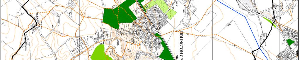
8 4a) Wetlands Nature Reserve access, habitat and visitor infrastructure improvements to create exemplary safe and welcoming nature reserve for all. 4b) Access hub development creation, upgrading and promotion of radial network of access routes from the Millennium Country Park into the wider Marston Vale, linking to other GI assets and communities. 4c) Expansion/Links: Rookery Pit North proposed nature reserve extension to the existing Park with wetlands, surrounding grasslands including great crested newt habitats, and new access links. 4d) Expansion/Links: Berry Wood proposed linkage to nearby under-utilised Berry Wood site (in Bedford Borough) as part of B-MK Waterway GI corridor development and enhancement. The Mid Beds GI Plan will be reviewed in late 20. This Parish GI Plan, along with the range of others commissioned at the same time across the former Mid and South Beds areas over the last few years, will be used to inform any future revision. Lidlington s Green Infrastructure Plan results GI Plan Map The map that follows illustrates the aspirations identified by the community of Lidlington for the future provision and enhancement of their Green Infrastructure. 'Proposed Allocation Sites' identify where future development (housing and/or employment) is considered appropriate. Where such sites overlap with identified GI aspirations, consideration should be given to: whether the aspiration/s can be delivered as part of a potential built development, or whether an alternative location for the aspiration(s) can be found. Such developments may contribute, either financially or through direct works, to the implementation of GI aspirations. The table in the map is shown below for clarity, with each numbered aspiration relating to a point on the map. 7

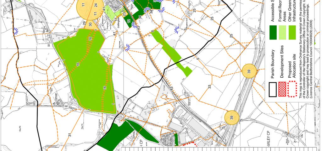

9 8
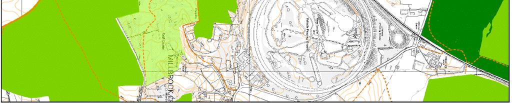
10 Table (i) Green Infrastructure Plan Aspirations Ref Aspirations Identified at Lidlington Workshop Access for horse riders, cyclists and walkers around Brogborough Lake. Car park also required. Missing cycle & bridleway adjacent to railway. Gates at each end stop access for buggies etc. Footpath to Marston - Pavement to follow road. Access for horse riders, cyclists and walkers from Lidlington to Millennium Country Park. Footpaths. Upgrade footpath to bridleway. Improve drainage. Path from bridleway to join footpaths without having to walk along road. Safe route to BOAT. Make graveyard green space. Views to Bedford and east. Views obscured by Leylandii. Remove trees. Enhance historical site - need Time Team! Sports Field. Bridleway round test track known as 'The Bumps'. St Margarets - Preserve building. Visible from many points in village. Needs listing. Triangular junction of Lombard St/Church St - continue as planned green space. Footpaths not accessible due to lake. Very narrow footpath. Safe bridleway. Village pond. Link Greensand Ridge footpath to BOAT. Roadside planting. Planting at railway station Dog walking/exercise enclosure/extra allotment Thrupp End mounds Bridleway link from Feoffee Lane to Boughton End Lane. Rights of way information at station, eg: paths, wildlife, ecology. Route around Lidlington Pit. Lidlington Pit - promised to village as part of Shanks planning 994. Cycle path. Link bridleway to footpath. Public space overlooking lake Cycle route to Holcote Wood route 5 Link Greensand Ridge walk with byway/bridleway to Steppingley. Link bridleway. Link bridleway - remove gate if necessary for access. Footpath/cyclepath/bridleway to Millennium Country Park. Bridleway to Millennium Park (as promised). Keep views open at Top Farm, refrain from intensive planting. Suggest orchard/hardwood planting - see Woodland Trust. Improve area near old Scout Hut. Pond area dried up. New bridges over bypass are not accessible safely by horses - cattle grid appearance Plant hedgerow between cemetery and footpath. Hazel/hawthorn etc. Footpaths not accessible. View over village now obscured by one tree that has grown too large. Bridleway link required from Brogborough Middle Farm to Bye Road. Bridge required across A507 to carry bridleway connection. 9
11 Priorities During the second workshop, the original aspiration list was made available to attendees who were asked to indicate which of the aspirations put forward they considered to be priority. In addition new aspiration were added to the list and these were included in the prioritisation process. The following aspirations were identified as the priorities at the community workshops. Table (ii) Priority aspirations, listed in order; highest priority first ref Priority Access for horse riders, cyclists and walkers around Brogborough Lake. Car park also required Priority 2 4 Access for horse riders, cyclists and walkers from Lidlington to Millennium Country Park Priority 3 4 St. Margarets preserve building. Visible from many points in the village. Needs listing Priority 4 27/28 Route around Lidlington Pit/Lidlington Pit promised to village as part of Shanks planning in 994 0
12 Action Plan Table (iii) Organisations to lead and support the implementation of aspirations with possible timescales (as where currently identified) Green Infrastructure Proposal Possible lead partner Other possible partners Access for horse riders, cyclists and walkers around Brogborough Lake. Car park also required Missing cycleway and bridleway adjacent to railway. Gates at each end stop access for buggies etc. Footpath to Marston - pavement to follow road Access for horse riders, cyclists and walkers from Lidlington to Millennium Country Park Footpaths need connections Upgrade footpath to bridleway Improve drainage Path from bridleway to join footpaths without having to walk along road. Safe route to BOAT (Byway Open to All Traffic) Make graveyard green space. Views to Bedford and east. Views obscured by Leylandii. Remove trees. Enhance historical site - need Time Team! Sports Field Bridleway round test track known as 'The Bumps' St Margarets - Preserve building. Visible from many points in village. Needs listing Triangular junction of Lombard St/Church St - continue as planned green space Footpaths not accessible due to lake Very narrow footpath Safe bridleway Village pond Link Greensand Ridge footpath to BOAT Roadside planting MVT Community priority MVT Community priority Planting at railway station Dog walking/exercise enclosure/extra allotment Thrupp End mounds Bridleway link from Feoffee Lane to Boughton End Lane Rights of way information at station, eg: paths, wildlife, ecology 28 Route around Lidlington Pit Lidlington Pit - promised to village as part of Shanks planning 994 Additional comments CBC Diocese LPC/WT CBC CBC Diocese LPC/CBC Community priority LPC LPC CBC CBC CBC MVT Network Rail/MVT LPC CBC Community priority Community priority 27 Timesca le CBC
13 LPC CBC MVT Cycle path. Link bridleway to footpath. Public space overlooking lake Cycle route to Holcote Wood Route 5 Link Greensand Ridge walk with byway/bridleway to Steppingley. Link bridleway. Link bridleway - remove gate if necessary for access. Footpath/cyclepath/bridleway to Millennium Country Park. Bridleway to Millennium Park (as promised). Keep views open at Top Farm, refrain from intensive planting. Suggest orchard/hardwood planting - see Woodland Trust. Improve area near old Scout Hut. Pond area dried up. New bridges over bypass are not accessible safely by horses - cattle grid appearance Plant hedgerow between cemetery and footpath. Hazel/hawthorn etc. Footpaths not accessible. View over village now obscured by one tree that has grown too large Bridleway link required from Brogborough Middle Farm to Bye Road Bridge required across A507 to carry bridleway connection Lidlington Parish Council Central Bedfordshire Council Marston Vale Trust LPC MVT MVT MVT MVT MVT LPC LPC MVT CBC RoWC Rights of Way (CBC) WT Wildlife Trust Note Involvement of the landowner/occupier is assumed in all cases 2
14 Appendix Living Network Parish Map Pack: Background information on GI themes used at consultation workshops to inform discussion and aspiration identification ) Context Map This map shows the parish boundary and how the parish relates to neighbouring communities. 2) Landscape Map The landscape map shows the position of contours within your parish. It also has the areas at risk from a % chance flood from a river marked. Contours and flood zones can be useful when creating green infrastructure corridors. The small 3D map shows how the topography of Lidlington relates to the rest of Bedfordshire. 3) Biodiversity Map This map shows the location of designated sites, important habitats and opportunities to enhance wildlife in Lidlingon. Within the parish there are 5 County Wildlife Sites (CWS), Brogborough Lake, Boughton End Grasslands, Millbrook Warren, Heydon Hill and Lidlington Pit. CWSs are sites that have been recognized as important for wildlife when assessed against a set of criteria. The selection guidelines consider aspects of the site such as size, diversity, rarity, fragility, typicalness and recorded history. Recognition as a CWS does not confer protection on the site, or right of access, however for any significant change of land use the planning authorities will expect the wildlife interest to be taken into account alongside other normal planning considerations. Local conservation organisations may comment on planning applications that could affect a CWS. The species rich permanent grasslands within the parish are important for many animals and plants. Green infrastructure planning can help to link or buffer existing wildlife sites, providing them with increased protection from harmful activities and making their wildlife populations more sustainable. The Biodiversity Network suggests where this could be most beneficial. If you would like further information or advice about the wildlife in your parish, please contact either Central Bedfordshire Council Ecologist, Liz Anderson (Tel: or elizabeth.anderson@centralbedfordshire.gov.uk) or The Wildlife Trust (Tel: or bedfordshire@wildlifebcnp.org). The Bedfordshire and Luton Biodiversity Recording and Monitoring Centre (BRMC) has a wealth of records about the species seen in your parish and is beginning to compile habitat data. If you would like to access this resource please contact them (Tel: or brmc@bedsbionet.org.uk). 4) Historic Environment Map A variety of historic sites are shown on this map. Integrating these sites into green infrastructure plans can help to preserve parish history. The numbers next to most of the site boundaries represent locations in the Historic Environment Record (HER), which is kept at Borough Hall in Bedford. The table below gives a brief summary of each numbered site; more details are available from the HER, along with historic maps of your parish. Due to the scale of this map only Listed Buildings are shown, however, there are many other historically important buildings recorded. For advice or further information about historic areas in your parish please contact the Historic Environment Information Officer at Central Bedfordshire Council (Tel: or stephen.coleman@centralbedfordshire.gov.uk). 3
15 HER Feature number 3 MOAT & DESERTED MEDIEVAL VILLAGE Thrup End 55 MOAT Lower End Farm 56 MOAT 485 ROMAN ROAD, viatores no DEER PARK Brogborough 785 'LIDLINGTON'(EARLY ANGLOSAXON PLACENAME) 594 ROMAN OCCUPATION, Office Cottages 2949 SAND PIT HER Feature number 667 MARSTON VALLEY BRICKWORKS & CLAY PIT 783 MOAT 8325 GREEN LANE 8400 HULCOT WOOD 8763 DEER PARK Beckerings Park 9024 ALL SAINTS' PARISH CHURCHYARD 9595 COMBES PARK also known as LIDLINGTON PARK 594 BEDFORD-BLETCHLEY RAILWAY 3073 LIDLINGTON WOOD 366 HEYDON HILL Ancient Woodland 3336 FISHPONDS 3337 LIANCES FIELD 3339 CONEY HILL 442 OLD TURNPIKE 4698 CROPMARK & QUARRY, S of Woburn Road 4699 CIRCULAR CROPMARK 597 BARNS AT VALE FARMHOUSE 6459 MILBROOK PROVING GROUND 6509 MEDIEVAL SETTLEMENT, Lower End 6899 BOUGHTON END MEDIEVAL SETTLEMENT 2950 SAND PIT 2979 CLAY PIT WINDMILL RIDGE & FURROW RIDGE & FURROW MOAT Vale Farm MOAT Escheat 5080 ROADWAY Boughton End 530 PARISH BOUNDARY EARTHWORK 6667 CLAY PIT 6668 CLAY PIT 6669 CLAY PIT 5) Access, Open Space and Recreation Map This map shows the positions of open spaces (e.g. golf courses, recreation grounds or school playing fields) within your parish. Not all of them are accessible to the public. Rights of Way are key to providing access to open spaces within green infrastructure plans. When creating networks, access barriers (such as busy roads) would need to be considered. 4


16 5

17 6
18 7


19 8


20 9
21 Appendix 2 - Numbers, age and gender of attendees - combined results (2 events) Age and gender Under Total Male Male (%)* 0% 3% 8% 6% 3% 3% Female Female (%)* 0% 5% 8% 8% 24% 3% 22 Total 38 * % of total attendance Length of time resident in Lidlington Don't -5 yr live here <yr 6-0 yr -25yr >25 yr Total Male Male (%)* % 0% 3% 3% 3% % Female Female (%)* % 3% 3% 3% 6% 8% Total * % of total attendance Notes Mid Beds District Council Open Space, Sports and Recreation Needs Assessment Technical Report, Sept 2008 Prepared by: Ashley Godfrey Associates. In association with Phil Back Associates and a2b Spatial Intelligence 20
Mapping produced by the Bedfordshire and Luton Biodiversity Recording and Monitoring Centre
 Mapping produced by the Bedfordshire and Luton Biodiversity Recording and Monitoring Centre Chalton Parish Green Infrastructure Plan Methodology In April 2007 Chalton Parish Council were approached with
Shillington. Green Infrastructure Plan. October Shillington Parish Council
 Shillington Green Infrastructure Plan October 2010 Shillington Parish Council SHILLINGTON S GREEN INFRASTRUCTURE PLAN Introduction: Shillington s Green Infrastructure (GI) Plan is part of a programme of
Billington Parish Green Infrastructure Plan
 Billington Billington Parish Green Infrastructure Plan Methodology Following a presentation to the Annual Parish Meeting, The Greensand Trust was invited to attend the next Parish Council Meeting. The
Neighbourhood Planning Local Green Spaces
 Neighbourhood Planning Local Green Spaces Introduction... 2 1. Why green space is important... 4 2. Neighbourhood plans and green space... 6 3. Evidence... 8 Statutory designations... 9 Green space audit...
BEDFORD BOROUGH COUNCIL PLAN IMPLEMENTATION MONITORING REPORT
 BEDFORD BOROUGH COUNCIL PLAN IMPLEMENTATION MONITORING REPORT 2017-18 Summary 1 Progress on local development documents 1 Local development documents adopted in the monitoring period 1st April 2017 31st
CENTRAL BEDFORDSHIRE COMMITTED TO WORKING TOGETHER WITH LOCAL COMMUNITIES
 WELCOME Thank you for coming to our consultation event to find out more about our emerging proposals for Hayfield Park, a residential development jointly promoted by the Hayfield Consortium: Martin Grant
Elderberry Walk. Developer HAB Housing
 Case studies Elderberry Walk Developer HAB Housing Development of 161 new homes on the former Dunmail Primary School site, focused around a central green street, with retained trees, new multifunctional
3. Neighbourhood Plans and Strategic Environmental Assessment
 1. Introduction This report sets out a draft Screening Determination for the Preston Parish Council s Neighbourhood Plan and has been prepared by rth Hertfordshire District Council. The purpose of the
Wildlife and Planning Guidance: Neighbourhood Plans
 Wildlife and Planning Guidance: Neighbourhood Plans This Leaflet is one of a series of 4 Wildlife and Planning Guidance Leaflets and is intended to provide useful information to assist you to campaign
Statement of Community Involvement LAND OFF SOUTHDOWN ROAD HORNDEAN, HAMPSHIRE
 LAND OFF SOUTHDOWN ROAD HORNDEAN, HAMPSHIRE CONTENTS Page 1. Introduction 3 2. Pre-application Discussions 4 3. The Consultation Process 5 4. Consultation Feedback 7 5. Responses to Consultation Feedback
8.0 Design and Form of Development 43/
 42/ 8.0 Design and Form of Development 43/ Rothwells Farm, Golborne/ Development Statement Figure 7. Site Constraints Key 44/ Site Boundary 360 Bus Route/Stops Existing Trees Underground Water Pipe Sensitive
Public Consultation. Land at Monks Farm, North Grove. Welcome
 Welcome Welcome to our public exhibition for development on Land at Monks Farm, orth Grove. Gallagher Estates and Gleeson Strategic Land are preparing an outline planning application for new homes, open
WELCOME. North East Haverhill. The Planning Process
 WELCOME North East The site to the North East of, known as Great Wilsey Park, is identified by St Edmundsbury Borough Council in its Core Strategy as capable of delivering a Sustainable Urban Extension.
Newcourt Masterplan. November Exeter Local Development Framework
 Newcourt Masterplan November 2010 Exeter Local Development Framework Background The Exeter Core Strategy Proposed Submission sets out the vision, objectives and strategy for the development of Exeter up
Settlement Boundaries Methodology North Northumberland Coast Neighbourhood Plan (August 2016)
") Introduction This background paper sets out a methodology for the definition of settlement boundaries in the North Northumberland Coast Neighbourhood Plan. The neighbourhood plan is planning positively
Introduction This background paper sets out a methodology for the definition of settlement boundaries in the North Northumberland Coast Neighbourhood Plan. The neighbourhood plan is planning positively
Green Infrastructure planning must be evidence led, thus the importance of this stage in collating your information and responses.
 Green Infrastructure Consultation Proforma Recipients: Andy Maginnis (Countryside Services) regarding access, recreation and tourism Ed Dursley (Transport) regarding access and movement Steve Bloomfield
The proposals presented in September drew a large number of comments and feedback and have been grouped together as follows:
 Appendix A Stakeholder presentation + powerpoint slides Planning Context and Emerging Proposals presentation Nick Tyrrell, Alder King, Planning Consultants Alder King began by setting the site context
SPG 1. * the northern and western sections which are open fields used for pasture and grazing;
 SPG 1 1.0 INTRODUCTION This development brief is based on the allocation of the Priors Hall site for employment and countryside recreational purposes in the Corby Borough Local Plan. The brief is intended
INTRODUCTION NORTH HEYBRIDGE GARDEN SUBURB
 INTRODUCTION This event is being hosted by the promoters of the proposed North Heybridge Garden Suburb who are working with Maldon District Council and other key stakeholders on the preparation of a comprehensive
Neighbourhood Planning Guidance Local Green Spaces
 Neighbourhood Planning Guidance Local Green Spaces Introduction This guidance note has been produced for communities preparing neighbourhood plans in North Dorset to help them to identify, assess and designate
LONGDEN VILLAGE DEVELOPMENT STATEMENT
 LONGDEN VILLAGE DEVELOPMENT STATEMENT 2017-2027 1 Longden Development Statement 2017-2027 15/01/18 1. Background 1.1 Longden Village Longden village is a very rural and traditional community first mentioned
OKEFORD FITZPAINE NEIGHBOURHOOD PLAN
 OKEFORD FITZPAINE NEIGHBOURHOOD PLAN Dear Parishioner, The Neighbourhood Plan Project Team have prepared this leaflet to summarise the full Neighbourhood Plan document. It provides a summary of the Vision,
Biodiversity The number and variety of organisms found within a specified area an important measure of the health and vitality of an area s ecology
 ANNEX B - GLOSSARY Agri-environmental Schemes Agri-environmental Schemes operate at multiple levels; from encouraging traditional farming practices and protecting landscapes to specifying management regimes
ALLERTHORPE NEIGHBOURHOOD PLAN
 Allerthorpe s Neighbourhood Plan sets out a vision for the Parish for the next 15 years (2018 2033) that builds on and reflects the opinions and views of parish residents. VISION In 2033 Allerthorpe will
Kibworth Harcourt. Introduction. Introduction
 Introduction Introduction Welcome to this public exhibition on the proposals for the delivery of new homes on land at The Kibworths. The purpose of today s exhibition is to give you the opportunity to
The Fairfield Partnership Vision for North-East Elsenham
 The Fairfield Partnership Vision for North-East Elsenham August 2009 Frequently Asked Questions Who is The Fairfield Partnership? The Fairfield Partnership is a joint venture between Marchfield Developments
Site Assessment Technical Document Appendix A: Glossary
 Central Bedfordshire Council www.centralbedfordshire.gov.uk Site Assessment Technical Document Appendix A: Glossary July 2017 1.1.11-1 - ii Appendix A: Glossary Term Agricultural Land Classification AONB
BREEDON NORTHERN LIMITED
 Non Technical Summary CONTENTS 1 INTRODUCTION... 1 2 SITE DESCRIPTION... 1 3 DESCRIPTION OF THE DEVELOPMENT... 6 4 NEED FOR THE DEVELOPMENT... 8 5 KEY ISSUES CONSIDERED IN THE ENVIRONMENTAL IMPACT ASSESSMENT...
Welcome to our Public Consultation
 About our development This exhibition gives you the chance to view and comment on our emerging plans for a proposed residential development located on land to the West of Alwyn Road, Rugby. Welcome to
DUNSFOLD NEIGHBOURHOOD PLAN Site Selection Policies
 DUNSFOLD NEIGHBOURHOOD PLAN Site Selection Policies The criteria for assessing sites for future housing and business development in Dunsfold are set out below. (Development criteria, covering what it is
Schedule of Planning Applications Committee Date: 23 May Reference: 06/17/0726/F Parish: Hemsby Officer: Mr J Beck Expiry Date:
 Schedule of Planning Applications Committee Date: 23 May 2018 Reference: 06/17/0726/F Parish: Hemsby Officer: Mr J Beck Expiry Date: 22-05-2018 Applicant: Proposal: Site: Mr Gillett Change of use to the
ENVIRONMENTAL AND LANDSCAPE MAPPING
 APPENDIX IV : Environmental and Landscape Mapping ENVIRONMENTAL AND LANDSCAPE MAPPING Calveley Neighbourhood Plan November 2016 ENVIRONMENTAL AND LANDSCAPE MAPPING Calveley Neighbourhood Plan Calveley
Welford-on-Avon Neighbourhood Plan Consultation Event Sunday, 6 April Your name Your address
 Welford-on-Avon Neighbourhood Plan Consultation Event Sunday, 6 April 2014 Your name Your email address Please either: - complete this feedback form and put it in the box before leaving the Memorial Hall
Welcome to our public exhibition
 About our development Welcome to our public exhibition This exhibition gives you the chance to view and comment on our proposals for a new residential development of 165 high-quality homes, along with
Reserved Matters application for a site that straddles the boundary between CBC and BBC
 BBC APPLICATION 15/02682/MAR NUMBER CBC APPLICATION CB/15/04294/RM NUMBER LOCATION Wixams Land at former storage depot, Bedford Road, Wilstead Bedfordshire PROPOSAL Reserved Matters Application for Strategic
To secure a Green Belt around Cambridge whose boundaries are clearly defined and which will endure for the plan period and beyond.
 4. GREEN BELT OBJECTIVES GB/a GB/b GB/c GB/d To secure a Green Belt around Cambridge whose boundaries are clearly defined and which will endure for the plan period and beyond. To maintain the purposes
ROCHFORD LOCAL DEVELOPMENT FRAMEWORK: Sustainability Appraisal/ Strategic Environmental Assessment. Rochford Core Strategy Preferred Options Document
 ROCHFORD LOCAL DEVELOPMENT FRAMEWORK: Sustainability Appraisal/ Strategic Environmental Assessment Non Technical Summary Rochford Core Strategy Preferred Options Document October 2008 SUSTAINABILITY APPRAISAL
Shenley Neighbourhood Development Plan Pre-Submission Plan, Regulation 14 Consultation
 Amanda Leboff, Clerk Shenley Parish Council Shenley Neighbourhood Plan c/o Shenley Parish Council The Hub London Road Shenley Herts WD7 9BS Sent by email to: clerk@shenleyvillage.org Hertfordshire County
WHITELEY TOWN COUNCIL NORTH WHITELEY DEVELOPMENT SEPTEMBER 2014
 WHITELEY TOWN COUNCIL NORTH WHITELEY DEVELOPMENT SEPTEMBER 2014 Dear Resident This Special Edition of the Whiteley Voice which has been prepared in conjunction with the North Whiteley Consortium is to
The Town and Country Planning (Environmental Impact Assessment) (Wales) Regulations 2016, Regulation 13 Scoping Opinion
 (Wales) Regulations 2016, Regulation 13 Scoping Opinion") Mr Graham Clark Berrys Newchurch Farm Kinnersley Hereford HR3 6QQ BY EMAIL The Town and Country Planning (Environmental Impact Assessment) (Wales) Regulations 2016, Regulation 13 Scoping Opinion SC/2017/0001
Mr Graham Clark Berrys Newchurch Farm Kinnersley Hereford HR3 6QQ BY EMAIL The Town and Country Planning (Environmental Impact Assessment) (Wales) Regulations 2016, Regulation 13 Scoping Opinion SC/2017/0001
Local Development Scheme
 Local Development Scheme 2012 2016 The Local Development Scheme (LDS) is a project plan that outlines how and when the Authority will update its planning policies and other associated documents. It ensures
Slough International Freight Exchange Proposals, Colnbrook+
 Welcome Welcome to this exhibition, which is being held in connection with our proposals for a new freight exchange facility on land to the north of the A4. Please take this opportunity to look at the
Scottish Natural Heritage. Better places for people and nature
 Scottish Natural Heritage Better places for people and nature Contents Summary... 3 SNH approach... 5 Place-making in policy and practice... 6 Developing the contribution of the natural heritage to place-making...
Welcome to our exhibition
 Welcome to our exhibition The Homes & Communities Agency (HCA) welcomes you to this public exhibition explaining our proposals for the redevelopment of the former Lea Castle Hospital site. About the Homes
Brockholes Wetland and Woodland Nature Reserve, Preston Lancashire
 Newlands Brockholes Wetland and Woodland Nature Reserve, Preston Lancashire Nature s Gateway to Lancashire NEWLANDS Brockholes: site profile Brockholes Wetland and Woodland Nature Reserve project area
Welcome to our exhibition
 Welcome to our exhibition housing development A46 Wildmoor Alcester Road Canal Quarter A422 Town Centre housing development Warwickshire-based IM Properties, one of the UK s largest privately owned property
Weaver Valley Green Infrastructure data
 Weaver Valley Green Infrastructure data Introduction Introduction Green infrastructure is a 150m 1 asset that we propose can be better used to provide competitive advantage and underpin sustainable growth
The Gwennap Parish Vision Statement
 QUICK GUIDE What is a Neighbourhood Development Plan? Ultimately it is a document used by developers or anyone wishing to submit a planning application that describes the vision, strategy, plans, regeneration,
WELCOME. Land North of STEVENAGE. We would like to thank you for attending our public exhibition today.
 WELCOME We would like to thank you for attending our public exhibition today. The purpose of this event is to share our proposals and hear your thoughts on our ideas. Members of the project team are on
Copyright Nigel Deeley and licensed for reuse under this Creative Commons Licence
 1 Copyright Nigel Deeley and licensed for reuse under this Creative Commons Licence Prepared by the Neighbourhood Plan Steering Group on behalf of Garway Parish Council with assistance from 2 Table of
Chapter 2: OUTLINE PLANNING APPLICATION PROPOSALS. A New Garden Neighbourhood Matford Barton 17
 Chapter 2: OUTLINE PLANNING APPLICATION PROPOSALS A New Garden Neighbourhood Matford Barton 17 2.1. SUMMARY AND STATUS OF THE PROPOSALS 2.1.1. The parameter plans and associated wording in this chapter
Policy and Resources Committee 10 th October Green Infrastructure Supplementary Planning Document (SPD) Summary. Title
 Summary. Title") Policy and Resources Committee 10 th October 2017 Title Report of Wards Status Urgent Key Enclosures Officer Contact Details Green Infrastructure Supplementary Planning Document (SPD) Deputy Chief Executive
Policy and Resources Committee 10 th October 2017 Title Report of Wards Status Urgent Key Enclosures Officer Contact Details Green Infrastructure Supplementary Planning Document (SPD) Deputy Chief Executive
10.0 Open Space and Public Realm
 10.0 Open Space and Public Realm 10.0 Open Space and Public Realm The Public Open Space System is comprised of: outdoor spaces available for public use that are either publicly owned (e.g., parks and
Welcome. Proposals for land at Smug Oak Lane BRICKET WOOD
 Proposals for land at Smug Oak Lane BRICKET WOOD Previous Linden Homes and Wates Developments scheme Welcome Welcome to Linden Homes and Wates Developments public exhibition. Working together as joint
Environmental and Landscape Mapping
 Environmental and Landscape Mapping In support of the Calveley Neighbourhood Plan November 2016 Project Name and Number: Calveley Neighbourhood Plan 16-025 Document Name and Revision: Environmental and
PROPOSED RESIDENTIAL DEVELOPMENT LAND AT GREEN LANE, YARM
 PROPOSED RESIDENTIAL DEVELOPMENT LAND AT GREEN LANE, YARM PUBLIC CONSULTATION YOUR VIEW MATTERS TO US LOCATION PLAN Thank you for taking the time to read this information leaflet regarding a proposed residential
East Harptree Landscape & Character Assessment
 East Harptree Landscape & Character Assessment Produced by East Harptree Parish Council in consultation with local residents September 2014 Contents The Parish of East Harptree: Objective Introduction
LITTLE FRANCE PARK, EDINBURGH
 LITTLE FRANCE PARK, EDINBURGH INTEGRATING ACTIVE TRAVEL ROUTES WITHIN A MASTERPLAN FROM THE OUTSET Location: Implemented: Edinburgh, Scotland 2016 - ongoing CASE STUDY The Little France Park cycling and
Development of land adjacent to Braggs Farm Lane and Rumbush Lane, Dickens Heath. Welcome. Today s exhibition. The proposal site
 Welcome Welcome to this event to discuss the development of land adjacent to Braggs Farm Lane. is currently in the preliminary stages of designing proposals to sensitively develop this site with high-quality
NORTH WEST LEEDS COUNTRY PARK AND GREEN GATEWAYS PROJECT. Country Parks Officer Douglas Louis
 NORTH WEST LEEDS COUNTRY PARK AND GREEN GATEWAYS PROJECT Country Parks Officer Douglas Louis Vision To Preserve, Improve and Promote Green Spaces and their Connectivity for People & Wildlife in North West
LOGGERHEADS NEIGHBOURHOOD PLAN LOCAL GREEN SPACE DESIGNATION OCTOBER 2016
 DRAFT LOGGERHEADS NEIGHBOURHOOD PLAN LOCAL GREEN SPACE DESIGNATION OCTOBER 2016 1. Introduction For many local communities, green infrastructure in and around their neighbourhood is an important issue,
Taking forward the All London Green Grid
 Taking forward the All London Green Grid Foreword Earlier this year, the Mayor published the All London Green Grid Supplementary Planning Guidance to the London Plan which set the vision, and framework,
Landscape and Heritage A Park landscape that embraces the physical, cultural and social heritage of the area
 80 Park Development Framework Our Aim for Landscape and Heritage A Park landscape that embraces the physical, cultural and social heritage of the area Why do we think it is important? The landscapes of
Neighbourhood Plan Representation
 Date: 10 th November 2017 Neighbourhood Plan Representation Land to the east of Callow Hill Road, Alvechurch Introduction This representation has been prepared by RPS Planning and Development on behalf
Plumpton Neighbourhood Plan Site Assessment Report
 Plumpton Neighbourhood Plan Site Assessment Report May 2016 1 Contents 1. Introduction 3 2. Methodology 4 2.1 Identification of Potential Sites 4 2.2 Assessment Process 5 2.3 Assessment Criteria 6 2.4
Land at Rampton Road. Cottenham
 Land at Rampton Road Cottenham Introduction TEP is preparing an outline planning application for 54 dwellings on 6.9 hectares of land adjacent to Rampton Road, Cottenham on behalf of the owners Cambridgeshire
Droitwich Spa 6. Reasoned Justification
 87 Droitwich Spa 6 Reasoned Justification 6.1 Droitwich Spa is identified in the settlement hierarchy (Policy SWDP1) as a main town being the largest settlement in Wychavon District with an estimated population
Response to the London Bridge Area Vision and Site Allocations within the New Southwark Plan
 1 Melior Place London SE1 3SZ 020 7407 4701 teamlondonbridge.co.uk info@teamlondonbridge.co.uk 28 April 2017 Response to the London Bridge Area Vision and Site Allocations within the New Southwark Plan
University Park, Worcester Non Technical Summary December 2011
 University Park, Worcester Non Technical Summary December 2011 Introduction UW Wrenbridge LLP, a Joint Venture Company of the University of Worcester and Wrenbridge Land Ltd (the Applicants ) intend to
Ebbsfleet Development Corporation
 Title of Paper Planning and Housing Delivery Report September 2018 Presented by Sub-Committee Mark Pullin, Chief Planning Officer Planning Committee Purpose of Paper and Executive Summary This paper provides
Frequently Asked Questions
 1. Where is Aylesbury Woodlands? Frequently Asked Questions Aylesbury Woodlands lies to the east of Aylesbury. It is bounded to the south by the A41. To the north is the Aylesbury Arm of the Grand Union
Basic Conditions Statement
 POTTON NEIGHBOURHOOD DEVELOPMENT PLAN Basic Conditions Statement Date: 19/10/2018 Version: 1 Status: draft Table of Contents 1 INTRODUCTION... 3 1.1 POTTON NEIGHBOURHOOD PLAN DESIGNATED AREA... 3 1.2 PREPARATION
DONCASTER METROPOLITAN BOROUGH COUNCIL. PLANNING COMMITTEE - 15th October Expiry Date:
 DONCASTER METROPOLITAN BOROUGH COUNCIL PLANNING COMMITTEE - 15th October 2013 Application 3 Application Number: 13/01158/FUL Application Expiry Date: 31st July 2013 Application Type: Full Application Proposal
ABOUT CALA HOMES CALA HOMES
 WELCOME Welcome to this public consultation event for our proposed development on land to the east of Salisbury Road, in Hungerford. Thank you for taking the time to come along today. Homes and Wates Developments
Richard Lemon Spatial Project Manager. Biodiversity and Green Infrastructure
 Richard Lemon Spatial Project Manager Biodiversity and Green Infrastructure A key concept: Multifunctionality Combining different functions on the same piece of land multi-functional green space, new
March General enquiries: Web site:
 REDEVELOPMENT OF WILSON HOSPITAL FOR MITCHAM LOCAL CARE CENTRE Community Planning & Design Brief for Merton Clinical Commissioning Group and London Borough of Merton March 2016 1. Mitcham Cricket Green
Wallingford Neighbourhood Plan
 Wallingford Neighbourhood Plan Introduction What is neighbourhood planning? Neighbourhood planning was introduced by the Localism Act 2011 to give local people more influence over how development comes
The journey so far. The new masterplan for Dargavel Village
 The journey so far Our vision for Dargavel Village began over ten years ago when the original masterplan for transforming the former Royal Ordnance Factory site into a thriving community was established.
SOUTH EAST LINCOLNSHIRE LOCAL PLAN: HOUSING PAPER DONINGTON (JUNE 2016)
") SOUTH EAST LINCOLNSHIRE LOCAL PLAN: HOUSING PAPER DONINGTON (JUNE 2016) 1 DONINGTON S PLACE IN THE SPATIAL STRATEGY 1.1 Policy 2 of the South East Lincolnshire Local Plan 2011-2036 Draft for Public Consultation
SOUTH EAST LINCOLNSHIRE LOCAL PLAN: HOUSING PAPER DONINGTON (JUNE 2016) 1 DONINGTON S PLACE IN THE SPATIAL STRATEGY 1.1 Policy 2 of the South East Lincolnshire Local Plan 2011-2036 Draft for Public Consultation
WELCOME. Olney Road, Lavendon INTRODUCTION. The Site. The Application. The Need for Housing. A Sustainable Location LAVENDON TURVEY OLNEY ROAD
 0 WELCOME INTRODUCTION Gladman Developments Ltd have successfully invested in communities throughout the UK over the past 0 years, developing high quality and sustainable residential, commercial and industrial
South Worcestershire Development Plan. South Worcestershire Design Guide Supplementary Planning Document
 South Worcestershire Development Plan South Worcestershire Design Guide Supplementary Planning Document Statement of Consultation: Early Engagement Scoping Paper February 2017 1. Introduction 1.1 This
LEEDS SITE ALLOCATIONS PLAN MATTER 3 GREEN BELT KCS DEVELOPMENT AUGUST 2017
 LEEDS SITE ALLOCATIONS PLAN MATTER 3 GREEN BELT KCS DEVELOPMENT AUGUST 2017 Smith Limited Suite 9C Joseph s Well Hanover Walk Leeds LS3 1AB T: 0113 2431919 F: 0113 2422198 E: planning@peacockandsmith.co.uk
Making the case for Sustainable Transport Project Potential
 Making the case for Sustainable Transport Project Potential The Structural Investment Fund (SIF) Strategy for Greater Lincolnshire identifies the barriers to growth identified by having poor transport
Planning and Sustainability Statement
 Land adjacent to Manor Farm, Catterick Village Pallett Hill Sand and Gravel Co Ltd Proposed 10 new dwellings, (6 No market dwellings and 4 No affordable dwellings) with access, associated car parking and
Stantonbury Neighbourhood Plan
 Stantonbury Neighbourhood Plan 2018-2031 Basic Conditions Statement October 2018 Intentionally blank 1.0 Basic Conditions Statement Introduction 1.1 This statement has been prepared by Stantonbury Parish
Key Decision Listed on Forward Plan Within Policy Policy Document. Contact Officer: Ian Haynes, Chief Spatial Planner ( )
") ITEM 12 CABINET 24 JUNE 2008 Key Decision Listed on Forward Plan Within Policy Policy Document Yes Yes No. GOVERNMENT CONSULTATION PAPER ON ECO-TOWNS Contact Officer: Ian Haynes, Chief Spatial Planner
ITEM 12 CABINET 24 JUNE 2008 Key Decision Listed on Forward Plan Within Policy Policy Document Yes Yes No. GOVERNMENT CONSULTATION PAPER ON ECO-TOWNS Contact Officer: Ian Haynes, Chief Spatial Planner
19 th October FAO Paul Lewis Planning Policy Branch Planning Division Welsh Assembly Government Cathays Park Cardiff CF10 3 NQ
 19 th October 2009 FAO Paul Lewis Planning Policy Branch Planning Division Welsh Assembly Government Cathays Park Cardiff CF10 3 NQ Dear Sir / Madam Technical Advice Note 6 Planning for Sustainable Rural
ENVIRONMENTAL INVENTORY
 Hungarton Neighbourhood Plan ENVIRONMENTAL INVENTORY Sites scoring 25/36 or more (70%) are judged to be the most important environmental and community sites and are proposed as Local Green Space. Other
WELCOME GYPSY LANE. Wider Site Location plan. Proposals for the development of LAND OFF FOXLYDIATE LANE WEBHEATH. Proposals for the development of
 WELCOME The developers are preparing an outline planning application for a residential led development and need the community s views in order to develop the proposals further WHAT IS PROPOSED? A high
About 10% of the Borough's population lives in the seven rural parishes. Population figures from the 1991 census are given below:-
 8. THE DISTRICT VILLAGES 8.1 Population About 10% of the Borough's population lives in the seven rural parishes. Population figures from the 1991 census are given below:- Village No. of Persons Cottingham
UTT/16/1466/DFO GREAT DUNMOW MAJOR
 UTT/16/1466/DFO GREAT DUNMOW MAJOR PROPOSAL: LOCATION: APPLICANT: AGENT: Reserved matters approval for the accesses to the site and principal roads within the site including spine road following outline
Welcome. Land adjacent Sandy Lane WALTHAM CHASE THE PROPOSED SITE
 Land adjacent Sandy Lane WALTHAM CHASE Existing Linden Homes developments Welcome Welcome to Linden Homes Southern s ( Linden ) public exhibition about its proposals for a range of high-quality homes for
Watford Local Plan Part 2 Publication Stage Environmental Report. Appendix 3: Consultation Comments
 Watford Local Plan Part 2 Publication Stage Environmental Report Appendix 3: Consultation Comments August 2016 Appendix 3 - Responses to Consultation of the Local Plan Part 2 As required by the SEA Directive,
MORETON, BOBBINGWORTH AND THE LAVERS OPEN SPACE AUDIT JULY Chapter 1 Introduction Page 2. Chapter 2 Allotments Page 3
 MORETON, BOBBINGWORTH AND THE LAVERS OPEN SPACE AUDIT JULY 2009 CONTENTS Chapter 1 Introduction Page 2 Chapter 2 Allotments Page 3 Chapter 3 Cemeteries And Graveyards Page 5 Chapter 4 Formal Playing Pitches
If you require support to complete this form please contact Jim Holford who will arrange suitable support to meet your needs
 If you require support to complete this form please contact Jim Holford who will arrange suitable support to meet your needs Jim Holford 1 Hillside Farm Chacewater TR4 8LU 07584135801 jimholford@gmail.com
Linden Homes Proposals for land off Ringwood Road, Verwood
 Welcome Welcome to Linden Homes first public exhibition displaying proposals for new homes on land off Ringwood Road in Verwood. Award-winning house builder Linden Homes, part of the Galliford Try Group,
Welcome to our public exhibition
 About Our Scheme Welcome to our public exhibition This exhibition gives you the chance to view and comment upon our emerging proposals for a new residential development of 68 new homes on the site of the
Habitat Regulations Assessment (HRA) Screening Determination. May 2017
 Screening Determination. May 2017") Cholsey Parish Council Cholsey Neighbourhood Plan Habitat Regulations Assessment (HRA) Screening Determination May 2017 Cholsey Neighbourhood Plan Page! 1 of! 10 SASR - HRA v1.1 Page Left Intentionally
Cholsey Parish Council Cholsey Neighbourhood Plan Habitat Regulations Assessment (HRA) Screening Determination May 2017 Cholsey Neighbourhood Plan Page! 1 of! 10 SASR - HRA v1.1 Page Left Intentionally
SOUTH CAMBRIDGESHIRE DISTRICT COUNCIL. Planning and New Communities Director
 SOUTH CAMBRIDGESHIRE DISTRICT COUNCIL REPORT TO: Planning Committee 9 January 2013 AUTHOR/S: Planning and New Communities Director S/2270/12/FL FEN DRAYTON 850m long flood defence embankment ranging in
Wildlife and Planning Guidance: Local Plans
 Wildlife and Planning Guidance: Local Plans This Leaflet is one of a series of 4 Wildlife and Planning Guidance Leaflets and is intended to provide useful information to assist you to campaign effectively