Shillington. Green Infrastructure Plan. October Shillington Parish Council
|
|
|
- Diane Shields
- 5 years ago
- Views:
Transcription


1 Shillington Green Infrastructure Plan October 2010 Shillington Parish Council
2 SHILLINGTON S GREEN INFRASTRUCTURE PLAN Introduction: Shillington s Green Infrastructure (GI) Plan is part of a programme of 19 parish and town GI plans across the area funded by Central Bedfordshire Council and facilitated by Bedfordshire Rural Communities Charity, the Greensand Trust and the Marston Vale Trust. was asked by Central Bedfordshire Council to assist in the production of the GI plans as it is a charity that works with local communities and landowners to conserve and enhance the landscape, wildlife and history in this area. At the heart of s work is the belief that the best results are achieved by empowering local communities, giving them a say in issues that affect them. has over 50 years experience of community development support and facilitating community consultation; and has nearly 20 years experience of planning and delivering green infrastructure projects in east Bedfordshire. What the plan shows The community green infrastructure plan shows information about the existing environment, and identifies aspiration and proposals from community members to enhance the local green infrastructure. These aspirations and proposals include priorities to maintain existing assets, enhance or restore existing assets, and create new green infrastructure. The information is shown on a map, which identifies both existing green infrastructure, and aspirations for improving the green infrastructure network. The plan as a whole is based on a robust approach to making and implementing a high quality green infrastructure network for the existing and future residents of Shillington. It should be acknowledged that not all of the aspirations identified will be delivered, because there are many other influencing factors, such as the views of landowners, existing planning permissions and allocations, potential future land use allocations and the cost of enhancements. The value of the plan lies in the fact that it has been produced by local residents for their own community. How the plan fits with other green infrastructure plans The plan can be used for individual towns or parishes, to show the local communities views on their local environment, and how they would like to see it enhanced. However, the plan has been produced as part of a programme of parish and town green infrastructure plans across Central Bedfordshire. In addition, there are other green infrastructure plans at different scales, namely a county level green infrastructure plan covering Bedfordshire and Luton and district level plans Mid Bedfordshire and Luton and Southern Bedfordshire. How the community green infrastructure plans fit with the strategic and district green infrastructure plans The community green infrastructure plans complement, but do not necessarily completely reflect the strategic and district green infrastructure plans. All GI planning is derived from the same GISbased information, albeit at different scales. The important difference is that district and strategic GI plan aspirations are drawn from a process of integrating multiple aspirations from different professional stakeholders, while community GI plans reflect purely the aspirations of the relevant community. Much of the time the local aspirations fit within the broader, more strategic aspirations of other GI plans, but occasionally they will not often because the local community are not aware of broader strategic aspirations. This is neither a problem nor a flaw, but does point to the importance of dialogue between the strategic and local levels. How the plan fits with other community green infrastructure plans The spatial scope of the plans broadly covers the administrative area of one town or parish council. However, the way that the local environment is used is not bounded by these administrative delineations, and in some cases, important aspirations and assets have been identified by communities outside their own administrative boundary. These aspirations may or may not be shared by communities from the adjacent town or parish. In parishes without a community GI plan, assets or aspirations may have been identified by an adjacent parish. These cannot be considered comprehensive, and have not necessarily been endorsed or agreed. 1
3 Neither can a lack of assets or aspirations identified through an adjoining plan be implied to suggest that there are no important assets or aspirations to improve the local area. How the plan can be used By the community The plan identifies what is important to the community, and what they would like to see improved to enhance the green infrastructure network. The plan can be used to support funding bids, to help communities make important improvements to their local environment. They can also provide a snapshot of the local environment. By the Local Planning Authority The plan is not a tool to prevent development, but it can inform planning decisions. The plan identifies what the community values in the local environment, and how it can be improved. This information can be used in pre-application discussions with developers, and to help evaluate submitted planning applications. The plan can also identify where financial benefits from development could be directed. By developers The plan identifies what is important in the local environment, and aspirations that the community has to improve the environment. Developers can use this information to identify important assets and aspirations for improvement, and consider how these could be integrated with, and delivered through, development proposals. Endorsement by Shillington Parish Council: Shillington Parish Council endorses the Green Infrastructure Plan and supports its recommendations. The Parish Council will seek opportunities to implement them and will review the plan annually. Endorsement by Central Bedfordshire Council: Central Bedfordshire Council recognises the need to provide a framework for green infrastructure provision in the District to meet the needs of existing and new residents and help create sustainable communities. In 2008, Mid Beds District Council produced a district-wide GI plan which has informed the Local Development Framework (LDF) Core Strategy and other Local Development Documents. The production of this parish-level GI Plan for Shillington gives added detail and together with the views of local people adds value to, and compliments, the Mid Beds District GI Plan and the Strategic GI Plan for Bedfordshire and Luton which was produced in All levels of GI Plan, including this Shillington GI Plan, will be used by the Authority in considering development proposals and assisting with the creation of green infrastructure assets. Support from : will support the community of Shillington in implementing this Plan where appropriate and feasible, providing advice, support in securing funding and leading practical works. 2
4 Definition of Green Infrastructure Green Infrastructure is the network of green spaces, access routes, wildlife habitats, landscapes and historic features which provide: a healthy and diverse environment attractive places to live and visit a good quality of life a sustainable future Green infrastructure assets include: Accessible Greenspace Country parks Green corridors Urban parks and gardens Habitats for wildlife including nature reserves, Sites of Special Scientific Interest and County Wildlife Sites. Historic parks and gardens and historic landscapes Scheduled Ancient Monuments Waterways and water bodies, including flooded quarries Public rights of way and cycleways Allotments Children s play space Formal sports facilities Cemeteries It is important to plan the green infrastructure network in the same way that we plan other networks and facilities, so that we can safeguard and enhance the environment and meet the needs of a wide range of people, both now and in the future. Green infrastructure also provides social and economic benefits, including: Places that can be used as a focus for community activity and events Opportunities to keep fit and healthy Helps support the local economy, including village shops, pubs and B&Bs Links between town and country helping people in rural areas access facilities Helps reduce the use of cars Aim of this Plan: To identify the key existing natural, historic, cultural and landscape assets, accessible greenspace and rights of way and to plan new features that will provide a connected network of green infrastructure for the benefit of present and future generations. Objectives To create a comprehensive document that will assist the local community to: Protect and where possible enhance the landscape, biodiversity and the historic environment Improve access and links for people and wildlife Provide a multi functional green infrastructure network Provide a source of information and guidance for planners, landowners and developers in formulating land use plans Promote community involvement Identify projects and produce an action plan to implement projects. Methodology & Community Involvement A methodology for the production of Parish Green Infrastructure Plans was developed in 2007 and 2008 by the PGIP Working Group and endorsed by the Beds & Luton Green Infrastructure Consortium. This standard methodology was adopted by Central Bedfordshire Council to produce their 20 commissioned GI Plans. 3
5 Common to all 20 of the GI Plans were two community workshops, to which local stakeholders and the wider community were invited. At the first workshop, a map pack summarising all of the information currently known about the parish s GI assets was presented; and consultees were asked to use this information to identify aspirations for enhancing and adding to the existing local GI. At the second workshop, these aspirations were reviewed, added to and prioritised. The following figures refer to those 34 consultees who attended the workshops: 65% were male; 35% were female (with more males in the upper age brackets). 12% were under 45 years old; 26% were aged between 45 and 59; and 62% were 60 and over. 26% had been residents of Shillington for less than 10 years; 24% had been residents for between 11 and 25 years; and 50% had lived in the parish for more than 25 years. The consultation activities in Shillington were undertaken in January February Green Infrastructure Themes: Green Infrastructure is composed of 5 themes; landscape, history, biodiversity, access and open space. These themes are presented separately to enable the different elements of GI to be considered both individually in detail and as part of the integrated GI network. The Living Networks pack of maps identify the existing GI assets for each of the above themes. The Living Network maps for Shillington can be viewed in Appendix 1. PPG17 study: In 2008 Ashley Godfrey Associates carried out an assessment of the open space, sport and recreational needs of the former Mid Bedfordshire district, following guidelines set out by the Government in Planning Policy and Guidance Note 17 (PPG17). This study looked at where existing open spaces are located and where deficiencies exist. It will help inform future decisions on the location, size and type of open spaces provided. Within the open space category, the following types are relevant to this study in terms of needs and deficiencies: Country Parks typically comprise a large area of land providing a mix of habitats and settings. Less formal than an urban park, but typically including facilities such as car parking, visitor centre, toilets, cafe, interpretation and signage; Natural & Semi-Natural Greenspaces areas of woodland, heathland, meadows, marsh, ponds & lakes, chalk grassland managed for their nature conservation value and benefits; Amenity Greenspace landscaped areas with no designated specific use, providing visual amenity or separating buildings or land uses; Informal Recreation Space areas providing opportunities for people to engage in activities such as walking, cycling, horse riding, dog walking, enjoying nature and informal play. Shillington is located in an area deficient in Country Park, Natural and Semi-Natural Greenspace and Amenity Greenspace provision. In terms of Informal Recreation Space, Shillington has a deficiency of over three hectares. The study recommended provision of at least one new Informal Recreation Space for Shillington. In addition, the study also looked at provision of allotments and community gardens, and found that in the eastern-sub area, within which Shillington is located, there is a significant deficiency of these spaces. 4
6 The Mid Bedfordshire GI Plan: The Mid Bedfordshire GI Plan identifies a network for protecting and enhancing GI across the whole of the former Mid Beds District. This Network is broken down into a series of areas, each with an Action List of potential projects to help deliver the Network. Shillington is in the Ivel Valley area of the Green Infrastructure Network identified in the Mid Beds GI Plan. The Mid Beds GI Plan will be reviewed in late This Parish GI Plan, along with the range of others commissioned at the same time across the former Mid and South Beds areas over the last few years, will be used to inform any future revision. 5

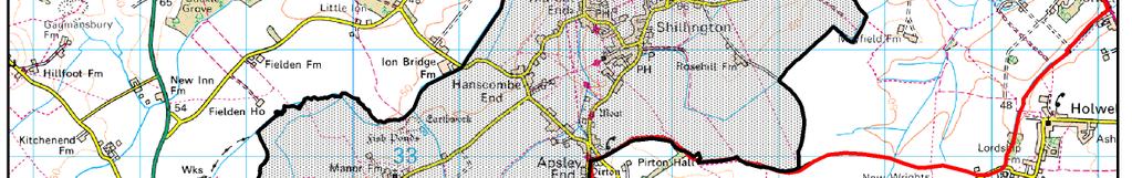
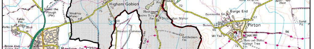
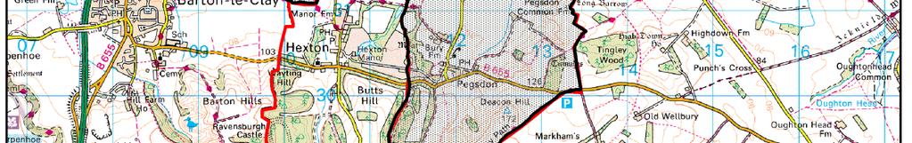
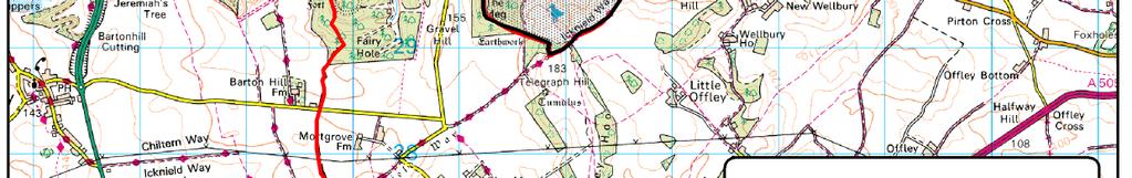
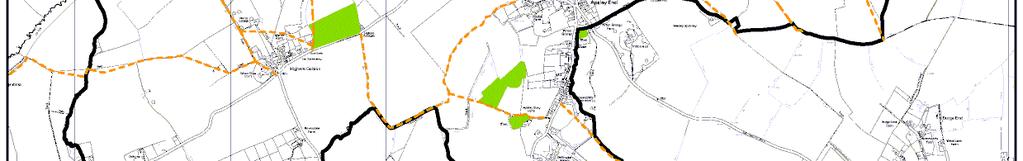
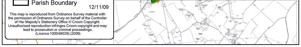
7 GI Plan Map The following map illustrates the aspirations identified by the community of Stotfold for the future provision and enhancement of their Green Infrastructure. 6
8 In the map above, 'Proposed Allocation Sites' identify where future development (housing and/ or employment) is considered appropriate. Where such sites overlap with identified GI aspirations, consideration should be give to a) whether the aspiration(s) can be delivered as part a potential built development, or b) whether an alternative location for the aspiration(s) can be found. Such developments may contribute, either financially or through direct works, to the implementation of GI aspirations. The table in the above map is shown below for clarity, with each numbered aspiration relating to a point on the map. GI Plan Aspirations ref Aspirational GI Enhancements 1 Upgrade public footpath, north of the village, and extend east (outside Parish) to provide surfaced cycleway to Meppershall. Upgrade public footpath, north of the village, and extend east (outside Parish) to provide bridleway to Meppershall. Upgrade public footpath, near Pegsdon / Knocking Hoe and extend (outside Parish) to provide surfaced cycleway to Pirton (Herts). Upgrade two ends of public footpath to bridleway near Pegsdon / Knocking Hoe, and create new bridleway to link them. Upgrade bridleway, south-east of village, to surfaced cycleway, and extend (outside Parish) towards Pirton (Herts). Upgrade public footpath, south-east of village, to surfaced cycleway, and extend (outside Parish) towards Pirton (Herts). Create new surfaced cycleway, south-east of village, to link Aspirations 3 and 4. Create new surfaced cycleway, south-east of village, to provide a shortcut route between Aspirations 3 and 4. Upgrade newly adopted public footpath, in village, to bridleway / cycleway. Create pavement / path, along Upton End Road, to complete a safe circular route, and extend to parish boundary. Upgrade footpath to bridleway (between Shillington Road and Meppershall Road). Create new bridleway (in Gravenhurst). Upgrade public footpath, off Shillington Road, to bridleway to create link to Stondon, Holwell and Pirton. Upgrade public footpath (far west of Parish) to bridleway to link to Higham Gobion. Create bridleway, north of Hexton (mainly outside Parish). Upgrades at both ends of bridleway presently public footpaths and create new section of bridleway to link to Hexton (mainly outside Parish Hexton and Barton). Upgrade public footpath to bridleway (near Shillington Manor). Upgrade footpath to bridleway and create new bridleway link to Pegsdon and Pegsdon Hills (east of Shillington Manor). Create new right of way linking present access routes east of Apsley End (outside Parish). Create new bridleway- across Hexton Common. Upgrade bridleway to cycleway (Knocking Hoe). Create new right of way linking present access routes (Knocking Hoe). Upgrade public footpath to bridleway / cycleway towards Pirton (outside Parish). Create new bridleway, south-east of village. Create new path / pavement alongside road between Hanscombe End and Higham Gobion. Create new public footpath link to Higham Gobion. Create new linking public footpath along Shillington Road. Create new riverside footpath to link several existing footpaths following Parish s western boundary. Create new public footpath to link several existing footpaths (by Hexton Common). Preserve (and maintain) rough grassland habitat, off Upton End Road. Create new open access sites (including Horn s Pasture) to maintain the green 1a 2 2a
9 A B C D E F centre of the village. (Afternote: the northernmost site is already owned by the parish council and is open access land). Create new woodland, south-east of village. Enhance existing grassland (quality & condition). Note: archaeological feature Enhance existing pond (quality & condition), at southern end of village. Enhance existing pond (quality & condition), at southern end of village. Plant up gaps in hedgerow both sides of road, between Hanscombe Road and Higham Gobion. Plant up gaps in hedgerow north side of Shillington Road. Create new picnic area off the Hitchin Road at Pegsdon. Improve road-side verge for horse / cycle riding along the Hitchin Road (B655) both inside and outside the parish boundary. Create public footpath along Shillington Road, south of Apsley End linking with Aspiration 17. Create public footpath to create circuit with other routes / aspirations - north-east of Apsley End. Surface paths to, and across, playing field for families and disabled people. Create public footpath alongside Meppershall Road Create public footpath alongside Apsley End Road, near Shillington Manor, linking to present rights of way. Improve surface of right of way from Hanscombe End Road to Shillington Church. Create new public footpath alongside Higham Road, to extend route noted in Aspirations 23 and 24. Create new public footpath alongside Hanscombe End Road linking with other rights of way. Preserve long views to Barton, Sharpenhoe Clappers and the Chilterns - Higham Gobion. Preserve views to Shillington and the Chilterns (Pegsdon) Higham Gobion. Preserve 3600 views of Beds and Herts Deacon Hill Preserve views to Pegsdon and the Chilterns - Knocking Hoe. Preserve views to the Chilterns south of Shillington Manor. Preserve panoramic views of parish and beyond (5 miles plus) northern end of Parish. Preserve views to Chicksands, Gravenhurst and Pirton northern end of Parish. Preserve near 3600 views from church of Parish and beyond. Preserve views to church, Pirton and Chibley. G H J NOTES: Orange arrows on the map show indicative route directions only. Aspirations that are mainly or wholly outside the Parish may not be given the same importance as those within the Parish. 8
10 Priorities: At each of the consultation events, participants were asked to indicate which of the aspirations put forward they considered to be priorities. A summary of the initial priorities was presented to the final workshop, whose attendees then participated in a more formal prioritising exercise. The following aspirations were identified as the priorities, with the most popular aspirations listed first: ref 8 A-J Priority aspirations, listed in order of highest priority first Priority 1 Create pavement / path, along Upton End Road, to complete a safe circular route, and extend to parish boundary. Priority 2 Preserve views in and around the parish. 29 Priority 3 Create new open access sites(including Horn s Pasture) to maintain the green centre of the village but see note below. 37 Priority 3 Improve road-side verge for horse / cycle riding along the Hitchin Road (B655) both inside and outside the parish boundary Priority 3 Upgrade newly adopted public footpath, in village to bridleway / cycleway. Priority 3 Upgrade public footpath, near Pegsdon / Knocking-Hoe and extend (outside parish) to provide surfaced cycleway to Pirton (Herts). Priority 3 Upgrade bridleway, south-east of village, to surfaced cycleway, and extend (outside parish) towards Pirton (Herts). Note: But also in Least favoured list, Priority 4 (below). Some respondents noted that the creation of a pavement / path along Upton End Road to the top of Bury Road (see Aspiration 8) is a priority, though the extension north towards Gravenhurst is not priority, (though acceptable). Some respondents agreed (see Aspiration 29) that maintaining the open green centre of the village is a top priority, but we do not agree that the areas concerned need to be open access to achieve this. A number of respondents noted their disagreement for the need for upgrading the bridleway to a surfaced cycleway (see Aspiration 3). Three further aspirations were given low priority by respondents: Create new picnic area off the Hitchin Road at Pegsdon (Aspiration 36) Create public footpath alongside Meppershall Road Upgrades at both ends of bridleway presently public footpaths and create new section of bridleway to link to Hexton (mainly outside parish Hexton and Barton). 9
11 Action Plan The table below outlines, where currently identified, organisations to lead and support the implementation of aspirations and indicates possible timescales. 1 1a 2 2a Green Infrastructure Proposals Possible lead partner Other possible partners Upgrade public footpath, north of the village, and extend east (outside Parish) to provide surfaced cycleway to Meppershall. Upgrade public footpath, north of the village, and extend east (outside Parish) to provide bridleway to Meppershall. Upgrade public footpath, near Pegsdon / Knocking Hoe and extend (outside Parish) to provide surfaced cycleway to Pirton (Herts). Upgrade two ends of public footpath to bridleway near Pegsdon / Knocking Hoe, and create new bridleway to link them. Upgrade bridleway, south-east of village, to surfaced cycleway, and extend (outside Parish) towards Pirton (Herts). Upgrade public footpath, south-east of village, to surfaced cycleway, and extend (outside Parish) towards Pirton (Herts). Create new surfaced cycleway, southeast of village, to link Aspirations 3 and 4. Create new surfaced cycleway, southeast of village, to provide a shortcut route between Aspirations 3 and 4. Upgrade newly adopted public footpath, in village, to bridleway / cycleway. Create pavement / path, along Upton End Road, to complete a safe circular route, and extend to parish boundary. Upgrade footpath to bridleway (between Shillington Road and Meppershall Road). Create new bridleway (in Gravenhurst). Upgrade public footpath, off Shillington Road, to bridleway to create link to Stondon, Holwell and Pirton. Upgrade public footpath (far west of Parish) to bridleway to link to Higham Gobion. Create bridleway, north of Hexton (mainly outside Parish). Upgrades at both ends of bridleway presently public footpaths and create new section of bridleway to link to Hexton (mainly outside Parish Hexton and Barton). Upgrade public footpath to bridleway (near Shillington Manor). Upgrade footpath to bridleway and create new bridleway link to Pegsdon and Pegsdon Hills (east of Shillington Manor). Create new right of way linking present Community priority CBC-Hw Community priority 10 Timescale Additional comments Community priority Community priority
12 access routes east of Apsley End (outside Parish). Create new bridleway- across Hexton Common. Upgrade bridleway to cycleway (Knocking Hoe). Create new right of way linking present access routes (Knocking Hoe). Upgrade public footpath to bridleway / cycleway towards Pirton (outside Parish). Create new bridleway, south-east of village. Create new path / pavement alongside road between Hanscombe End and Higham Gobion. Create new public footpath link to Higham Gobion. 25 Create new linking public footpath along Shillington Road. 26 Create new riverside footpath to link several existing footpaths following Parish s western boundary. Create new public footpath to link several existing footpaths (by Hexton Common). Preserve (and maintain) rough grassland habitat, off Upton End Road. CBC / CBC-Hw Create new open access sites (including Horn s Pasture) to maintain the green centre of the village. (Afternote: the northernmost site is already owned by the parish council and is open access land). Create new woodland, south-east of village. CBC / CBC / Enhance existing grassland (quality & condition). Note: archaeological feature Enhance existing pond (quality & condition), at southern end of village. Enhance existing pond (quality & condition), at southern end of village. Plant up gaps in hedgerow both sides of road, between Hanscombe Road and Higham Gobion. Plant up gaps in hedgerow north side of Shillington Road. Create new picnic area off the Hitchin Road at Pegsdon. CBC / CBC Improve road-side verge for horse / cycle riding along the Hitchin Road (B655) both inside and outside the parish boundary. Create public footpath along Shillington Road, south of Apsley End linking with Aspiration 17. Create public footpath to create circuit with other routes / aspirations -northeast of Apsley End. Surface paths to, and across, playing field for families and disabled people. CBC-Hw CBC-Hw Community priority Community priority
13 A-J Create public footpath alongside Meppershall Road Create public footpath alongside Apsley End Road, near Shillington Manor, linking to present rights of way. Improve surface of right of way from Hanscombe End Road to Shillington Church. Create new public footpath alongside Higham Road, to extend route noted in Aspirations 23 and 24. Create new public footpath alongside Hanscombe End Road linking with other rights of way. Preserve views in and around the parish. CBC CBC-Hw CBC / CBC-Hw CBC-Hw Community priority Beds Rural Community Charity Central Bedfordshire Council Highways (CBC) Rights of Way (CBC) Shillington Group Shillington Parish Council 12
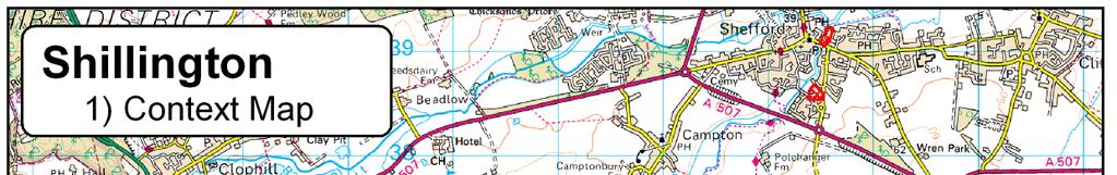
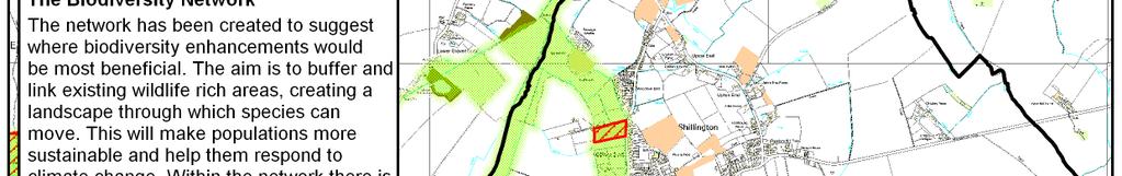
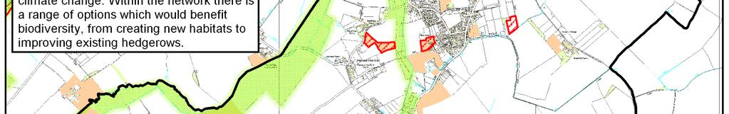
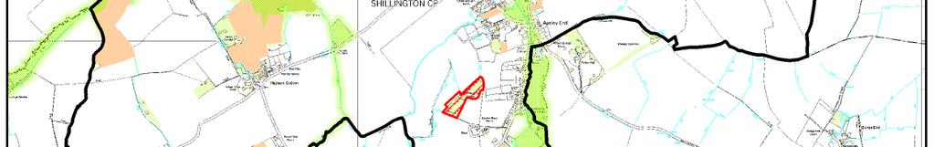
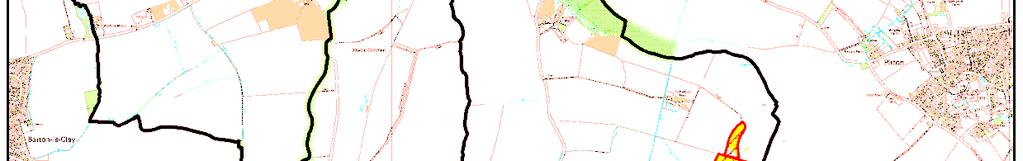
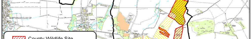
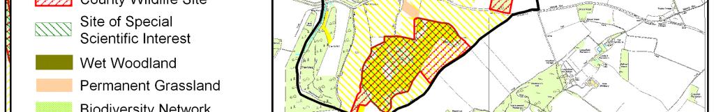
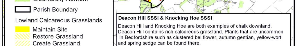
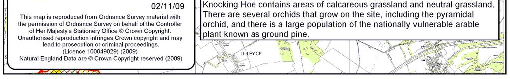
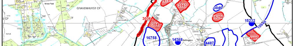
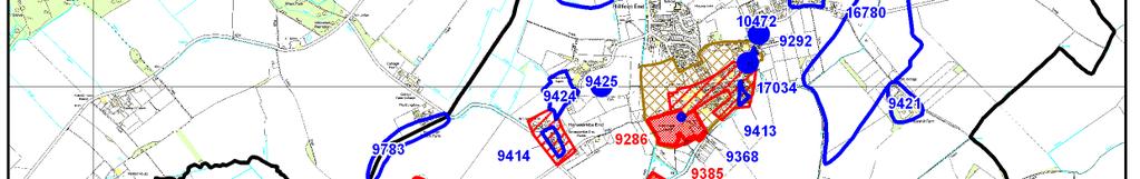
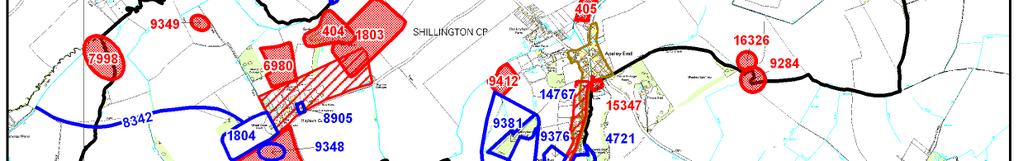
14 Appendix 1 Living Network Parish Map Pack: Background information on GI themes used at consultation workshops to inform discussion and aspiration identification. 1) Context Map This map shows the parish boundary and how the parish relates to neighbouring communities. 2) Landscape Map The landscape map shows the position of contours within your parish. It also has the areas at risk from a 1% chance flood from a river marked. Contours and flood zones can be useful when creating green infrastructure corridors. The small 3D map shows how the topography of Shillington relates to the rest of Bedfordshire. 3) Biodiversity Map This map shows the location of designated sites, important habitats and opportunities to enhance wildlife in Shillington. County Wildlife Sites (CWS) are sites that have been recognized as important for wildlife when assessed against a set of criteria. Designation as a CWS does not confer protection on the site, or right of access, however for any significant change of land use the planning authorities will expect the wildlife interest to be taken into account alongside other normal planning considerations. Local conservation organisations may comment on planning applications that could affect a CWS. There are also other sites within the parish which are important for wildlife. Green infrastructure planning can help to link or buffer existing wildlife sites, providing them with increased protection from harmful activities and making their wildlife populations more sustainable. The Biodiversity Network suggests where this could be most beneficial. If you would like further information or advice about the wildlife in your parish, please contact either Central Bedfordshire Council Ecologist, Liz Anderson (Tel: or elizabeth.anderson@centralbedfordshire.gov.uk) or The Wildlife Trust (Tel: or bedfordshire@wildlifebcnp.org). The Bedfordshire and Luton Biodiversity Recording and Monitoring Centre (BRMC) has a wealth of records about the species seen in your parish and is beginning to compile habitat data. If you would like to access this resources please contact them (Tel: or brmc@bedsbionet.org.uk). 4) Historic Environment Map A variety of historic sites are shown on this map. Integrating these sites into green infrastructure plans can help to preserve parish history. The numbers next to most of the site boundaries represent locations in the Historic Environment Record (HER), which is kept at Priory House, Chicksands. The table below gives a brief summary of each numbered site; more details are available from the HER, along with historic maps of your parish. Due to the scale of this map only Listed Buildings are shown, however, there are many other historically important buildings recorded. For advice or further information about historic areas in your parish please contact the Historic Environment Information Officer at Central Bedfordshire Council (Tel: or stephen.coleman@centralbedfordshire.gov.uk). 13
15 HER Number Feature Icknield Way HER Number 9298 Feature Roman Coins 'Church Panel' moated site Medieval Fishery at 'The Camp' Moat Moat Bowl Barrow, Tingley Field Plantation Round Barrow, Knocking Knoll, Shillington Watermill Strip Lynchets Lynchets Lynchets, Knocking Hoe Soil Marks Bronze Age Collared Urn Cropmarks Cropmarks Cropmarks, N of Pegsdon Common Farm Iron Age Boundary Earthwork Earthworks, Shillington Bury Farm Strip Lynchets Roman Settlement, N of Kittledean Farm Old Chalk Pit Old Chalk Pit Old Gravel Pit, Pegsdon Flints Iron Age Occupation Iron Age Pottery 9363 Old Chalk Pit Old Gravel Pit Moat, Apsley Bury Old Chalk Pit Old Chalk Pit Old Gravel Pit, Pegsdon Apsley Bury Wood Clay Pits Fishponds, Parsonage Farm The Water Meadow' Circular Cropmark Chalk Pits, Deacon Hill 9412 Strip Lynchets Strip Lynchets, Pegsdon Barn Linear Earthwork Burial Lynchets & Chalk Pit, E of Kettledean Farm Old Chalk Pit, SE of Kettledean Farm Old Gravel Pits, NE of Upton End Shillington Manor House, Aspley End Windmill Moat, Pegsdon Belt Quarry Cropmarks, N of Apsley Bury Wood May Green, Church End Hanscombe End Green Rosehill Farm Lynchet 9424 Ridge & Furrow Earthworks, Upton End Gates at Entrance, Manor House, Apsley End Road Entrance Gates, Pegsdon Lodge Ridge & Furrow Medieval Occupation, Handscombe End Roman & Medieval Coins 9447 Earthworks, at Aspley Bury Sangerel Mill Roman Road Road, Chibley-St Thomas' Chapel Roman Occupation, Han Furlong Cropmarks Circular Cropmark Socketed Axe Roman Villa, NE of Upton End, Shillington
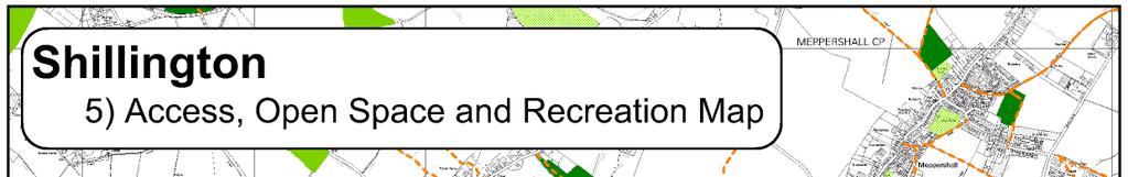
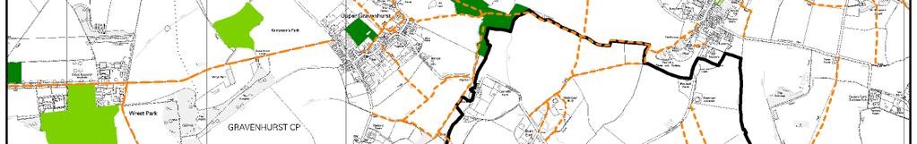
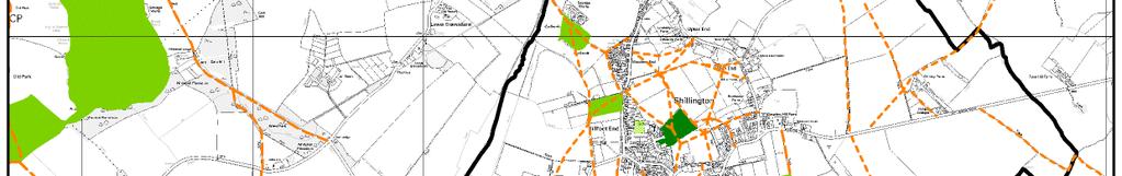
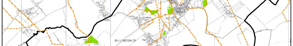
16 HER Number Feature Landscaped Grounds, Shillington Manor House, Aspley Bury Landscaped Grounds, part of Hexton Manor Pegsdon Iron Age Pottery HER Number Cropmarks, NE of Pegsdon Iron Age Occupation, NE of Shillington Bury Roman Brooch, Knocking Hoe Iron Age & Roman Occupation, E of Apsley End, Shillington Medieval Occupation, W of Pegsdon Common Farm, Shillington Iron Age Pottery, NE of Pegsdon Common Farm, Shillington Cropmarks, Medieval settlement, E of Westhey Manor Cropmarks, E of Shillington Mill Hanscombe Ley Wood, N of Hanscombe End Ring Ditch, W of Pegsdon Common Farm, Shillington Coprolite Workings, Stondon Road War Memorial Cropmarks, S of Higham Gobion Lime Kiln Slot Long Park Gravel Pit Close & Field Gallows Corner The Park, Parsonage Farm Windpump, Pegsdon Common Farm Roman Occupation on Noon Hill Pound on Shillington Green between Church and Upton End Small Chalk Quarry Medieval Pond, N of Pirton Grange, Shillington Road from New Inn to Higham St Margaret's Parish Churchyard Turnpike Road, Pegsdon 9291 Feature ) Access, Open Space and Recreation Map This map shows the positions of open spaces (e.g. golf courses, recreation grounds or school playing fields) within your parish. Not all of them are accessible to the public. Rights of Way are key to providing access to open spaces within green infrastructure plans. When creating networks access barriers, such as busy roads, would need to be considered. 15

17
18 17

19 18


20 19
21 20
Billington Parish Green Infrastructure Plan
 Billington Billington Parish Green Infrastructure Plan Methodology Following a presentation to the Annual Parish Meeting, The Greensand Trust was invited to attend the next Parish Council Meeting. The
Mapping produced by the Bedfordshire and Luton Biodiversity Recording and Monitoring Centre
 Mapping produced by the Bedfordshire and Luton Biodiversity Recording and Monitoring Centre Chalton Parish Green Infrastructure Plan Methodology In April 2007 Chalton Parish Council were approached with
Lidlington. Green Infrastructure Plan Lidlington Parish Council
 Lidlington Green Infrastructure Plan 20 Lidlington Parish Council Parish Green Infrastructure Plan Lidlington Introduction Lidlington s Green Infrastructure (GI) Plan is part of a programme of 9 parish
Neighbourhood Planning Local Green Spaces
 Neighbourhood Planning Local Green Spaces Introduction... 2 1. Why green space is important... 4 2. Neighbourhood plans and green space... 6 3. Evidence... 8 Statutory designations... 9 Green space audit...
Statement of Community Involvement LAND OFF SOUTHDOWN ROAD HORNDEAN, HAMPSHIRE
 LAND OFF SOUTHDOWN ROAD HORNDEAN, HAMPSHIRE CONTENTS Page 1. Introduction 3 2. Pre-application Discussions 4 3. The Consultation Process 5 4. Consultation Feedback 7 5. Responses to Consultation Feedback
Settlement Boundaries Methodology North Northumberland Coast Neighbourhood Plan (August 2016)
") Introduction This background paper sets out a methodology for the definition of settlement boundaries in the North Northumberland Coast Neighbourhood Plan. The neighbourhood plan is planning positively
Introduction This background paper sets out a methodology for the definition of settlement boundaries in the North Northumberland Coast Neighbourhood Plan. The neighbourhood plan is planning positively
3. Neighbourhood Plans and Strategic Environmental Assessment
 1. Introduction This report sets out a draft Screening Determination for the Preston Parish Council s Neighbourhood Plan and has been prepared by rth Hertfordshire District Council. The purpose of the
Reserved Matters application for a site that straddles the boundary between CBC and BBC
 BBC APPLICATION 15/02682/MAR NUMBER CBC APPLICATION CB/15/04294/RM NUMBER LOCATION Wixams Land at former storage depot, Bedford Road, Wilstead Bedfordshire PROPOSAL Reserved Matters Application for Strategic
WELCOME. North East Haverhill. The Planning Process
 WELCOME North East The site to the North East of, known as Great Wilsey Park, is identified by St Edmundsbury Borough Council in its Core Strategy as capable of delivering a Sustainable Urban Extension.
Planning and Sustainability Statement
 Land adjacent to Manor Farm, Catterick Village Pallett Hill Sand and Gravel Co Ltd Proposed 10 new dwellings, (6 No market dwellings and 4 No affordable dwellings) with access, associated car parking and
SPG 1. * the northern and western sections which are open fields used for pasture and grazing;
 SPG 1 1.0 INTRODUCTION This development brief is based on the allocation of the Priors Hall site for employment and countryside recreational purposes in the Corby Borough Local Plan. The brief is intended
To secure a Green Belt around Cambridge whose boundaries are clearly defined and which will endure for the plan period and beyond.
 4. GREEN BELT OBJECTIVES GB/a GB/b GB/c GB/d To secure a Green Belt around Cambridge whose boundaries are clearly defined and which will endure for the plan period and beyond. To maintain the purposes
BEDFORD BOROUGH COUNCIL PLAN IMPLEMENTATION MONITORING REPORT
 BEDFORD BOROUGH COUNCIL PLAN IMPLEMENTATION MONITORING REPORT 2017-18 Summary 1 Progress on local development documents 1 Local development documents adopted in the monitoring period 1st April 2017 31st
Site Assessment Technical Document Appendix A: Glossary
 Central Bedfordshire Council www.centralbedfordshire.gov.uk Site Assessment Technical Document Appendix A: Glossary July 2017 1.1.11-1 - ii Appendix A: Glossary Term Agricultural Land Classification AONB
Wildlife and Planning Guidance: Neighbourhood Plans
 Wildlife and Planning Guidance: Neighbourhood Plans This Leaflet is one of a series of 4 Wildlife and Planning Guidance Leaflets and is intended to provide useful information to assist you to campaign
Chalk, Cherries and Chairs Central Chilterns Landscape Partnership Scheme LANDSCAPE PARTNERSHIP DEVELOPMENT OFFICER JOB INFORMATION PACK
 Chalk, Cherries and Chairs Central Chilterns Landscape Partnership Scheme LANDSCAPE PARTNERSHIP DEVELOPMENT OFFICER JOB INFORMATION PACK How to apply Please complete our application form, together with
OKEFORD FITZPAINE NEIGHBOURHOOD PLAN
 OKEFORD FITZPAINE NEIGHBOURHOOD PLAN Dear Parishioner, The Neighbourhood Plan Project Team have prepared this leaflet to summarise the full Neighbourhood Plan document. It provides a summary of the Vision,
Neighbourhood Planning Guidance Local Green Spaces
 Neighbourhood Planning Guidance Local Green Spaces Introduction This guidance note has been produced for communities preparing neighbourhood plans in North Dorset to help them to identify, assess and designate
CENTRAL BEDFORDSHIRE COMMITTED TO WORKING TOGETHER WITH LOCAL COMMUNITIES
 WELCOME Thank you for coming to our consultation event to find out more about our emerging proposals for Hayfield Park, a residential development jointly promoted by the Hayfield Consortium: Martin Grant
Great Easton Neighbourhood Plan Statement of Basic Conditions
 Great Easton Neighbourhood Plan 2017-2031 Statement of Basic Conditions OCTOBER 2016 GREAT EASTON PARISH COUNCIL Contents 1.0 Introduction....Page 2 2.0 Summary of Submission Documents and Supporting Evidence..
Shenley Neighbourhood Development Plan Pre-Submission Plan, Regulation 14 Consultation
 Amanda Leboff, Clerk Shenley Parish Council Shenley Neighbourhood Plan c/o Shenley Parish Council The Hub London Road Shenley Herts WD7 9BS Sent by email to: clerk@shenleyvillage.org Hertfordshire County
UTT/16/1466/DFO GREAT DUNMOW MAJOR
 UTT/16/1466/DFO GREAT DUNMOW MAJOR PROPOSAL: LOCATION: APPLICANT: AGENT: Reserved matters approval for the accesses to the site and principal roads within the site including spine road following outline
Public Consultation. Land at Monks Farm, North Grove. Welcome
 Welcome Welcome to our public exhibition for development on Land at Monks Farm, orth Grove. Gallagher Estates and Gleeson Strategic Land are preparing an outline planning application for new homes, open
Welcome to our Public Consultation
 About our development This exhibition gives you the chance to view and comment on our emerging plans for a proposed residential development located on land to the West of Alwyn Road, Rugby. Welcome to
SOUTH CAMBRIDGESHIRE DISTRICT COUNCIL. Planning and New Communities Director
 SOUTH CAMBRIDGESHIRE DISTRICT COUNCIL REPORT TO: Planning Committee 9 January 2013 AUTHOR/S: Planning and New Communities Director S/2270/12/FL FEN DRAYTON 850m long flood defence embankment ranging in
LONGDEN VILLAGE DEVELOPMENT STATEMENT
 LONGDEN VILLAGE DEVELOPMENT STATEMENT 2017-2027 1 Longden Development Statement 2017-2027 15/01/18 1. Background 1.1 Longden Village Longden village is a very rural and traditional community first mentioned
Longhorsley Neighbourhood Plan
 Site Assessment 1. The availability of the site 1.1 Is the land owner willing for their site to be made available for development? 1.2 If yes, do you have any written evidence to back this up? Planning
Kibworth Harcourt. Introduction. Introduction
 Introduction Introduction Welcome to this public exhibition on the proposals for the delivery of new homes on land at The Kibworths. The purpose of today s exhibition is to give you the opportunity to
WHITELEY TOWN COUNCIL NORTH WHITELEY DEVELOPMENT SEPTEMBER 2014
 WHITELEY TOWN COUNCIL NORTH WHITELEY DEVELOPMENT SEPTEMBER 2014 Dear Resident This Special Edition of the Whiteley Voice which has been prepared in conjunction with the North Whiteley Consortium is to
Chapter 2: OUTLINE PLANNING APPLICATION PROPOSALS. A New Garden Neighbourhood Matford Barton 17
 Chapter 2: OUTLINE PLANNING APPLICATION PROPOSALS A New Garden Neighbourhood Matford Barton 17 2.1. SUMMARY AND STATUS OF THE PROPOSALS 2.1.1. The parameter plans and associated wording in this chapter
Everton s Neighbourhood Plan. Site Allocation - Assessment Criteria
 Everton s Neighbourhood Plan Site llocation - ssessment Criteria Introduction 1.1 This report assesses all the sites identified through the emerging Neighbourhood Plan for Everton and their potential for
INTRODUCTION NORTH HEYBRIDGE GARDEN SUBURB
 INTRODUCTION This event is being hosted by the promoters of the proposed North Heybridge Garden Suburb who are working with Maldon District Council and other key stakeholders on the preparation of a comprehensive
Local Development Scheme
 Local Development Scheme 2012 2016 The Local Development Scheme (LDS) is a project plan that outlines how and when the Authority will update its planning policies and other associated documents. It ensures
DUNSFOLD NEIGHBOURHOOD PLAN Site Selection Policies
 DUNSFOLD NEIGHBOURHOOD PLAN Site Selection Policies The criteria for assessing sites for future housing and business development in Dunsfold are set out below. (Development criteria, covering what it is
Appendix 2: List of superseded policies
 Appendix 2: List of superseded policies The table below sets out the policies that are to be superseded by this Local Plan. These policies will no longer be part of the development plan for Central Bedfordshire
Environment Agency Flood Risk Map for the Village of Bridge
 Environment Agency Flood Risk Map for the Village of Bridge December 2016 21 Objective F. Conserving and Enhancing the Natural Environment The National Planning Policy Framework states that the planning
WELCOME. Land North of STEVENAGE. We would like to thank you for attending our public exhibition today.
 WELCOME We would like to thank you for attending our public exhibition today. The purpose of this event is to share our proposals and hear your thoughts on our ideas. Members of the project team are on
Elderberry Walk. Developer HAB Housing
 Case studies Elderberry Walk Developer HAB Housing Development of 161 new homes on the former Dunmail Primary School site, focused around a central green street, with retained trees, new multifunctional
Wallingford Neighbourhood Plan
 Wallingford Neighbourhood Plan Introduction What is neighbourhood planning? Neighbourhood planning was introduced by the Localism Act 2011 to give local people more influence over how development comes
INTRODUCTION. Land West of Main Road, Stanton Harcourt THE SITE. Why is the Site Suitable for Development?
 0 INTRODUCTION THE SITE Application Boundary Gladman Developments Ltd has successfully invested in communities throughout the UK over the past 0 years, developing high quality and sustainable residential,
Stanwick Neighbourhood Plan
 Stanwick Neighbourhood Plan Heritage Audit Stanwick Neighbourhood Plan Steering Group August 2015 Purpose of the Heritage Audit It is a core planning principle within National Planning Policy Framework
The analysis of key visual characteristics and attributes that contribute to variations in the
 15.0 CHIGWELL/CHIGWELL ROW 15.1 Overview 15.1.1 Chigwell and Chigwell Row settlements are situated in the south of Epping Forest District, to the south of Abridge and southwest of Stapleford Abbotts. Both
March General enquiries: Web site:
 REDEVELOPMENT OF WILSON HOSPITAL FOR MITCHAM LOCAL CARE CENTRE Community Planning & Design Brief for Merton Clinical Commissioning Group and London Borough of Merton March 2016 1. Mitcham Cricket Green
WELCOME GYPSY LANE. Wider Site Location plan. Proposals for the development of LAND OFF FOXLYDIATE LANE WEBHEATH. Proposals for the development of
 WELCOME The developers are preparing an outline planning application for a residential led development and need the community s views in order to develop the proposals further WHAT IS PROPOSED? A high
Biodiversity The number and variety of organisms found within a specified area an important measure of the health and vitality of an area s ecology
 ANNEX B - GLOSSARY Agri-environmental Schemes Agri-environmental Schemes operate at multiple levels; from encouraging traditional farming practices and protecting landscapes to specifying management regimes
Public Consultation 23 January Peel Hall, Warrington Board 1. A message from Satnam... Site history...
 Board 1 A message from Satnam... Thank you for attending today s public consultation about proposals to develop a new residential neighbourhood at. The display boards show why the development is needed
BREEDON NORTHERN LIMITED
 Non Technical Summary CONTENTS 1 INTRODUCTION... 1 2 SITE DESCRIPTION... 1 3 DESCRIPTION OF THE DEVELOPMENT... 6 4 NEED FOR THE DEVELOPMENT... 8 5 KEY ISSUES CONSIDERED IN THE ENVIRONMENTAL IMPACT ASSESSMENT...
Joint Core Strategy Rushden Sustainable Urban Extension
 Date Page 1 of 18 Report Originator Title Planning Manager Joint Core Strategy Rushden Sustainable Urban Extension 1. PURPOSE OF REPORT 1.1 To consider representations received on the emerging Joint Core
Site ref: AS06 Site Name or Address: Murreys Court, Agates Lane
 Site ref: AS06 Site Name or Address: Murreys Court, Agates Lane Proposed Land Use: Total Site Area (Ha): Housing 1.85 Ha Description: It is understood that the owner has no plans to dispose of the site
Welcome to our public exhibition
 About our development Welcome to our public exhibition This exhibition gives you the chance to view and comment on our proposals for a new residential development of 165 high-quality homes, along with
Plumpton Neighbourhood Plan Site Assessment Report
 Plumpton Neighbourhood Plan Site Assessment Report May 2016 1 Contents 1. Introduction 3 2. Methodology 4 2.1 Identification of Potential Sites 4 2.2 Assessment Process 5 2.3 Assessment Criteria 6 2.4
Taking forward the All London Green Grid
 Taking forward the All London Green Grid Foreword Earlier this year, the Mayor published the All London Green Grid Supplementary Planning Guidance to the London Plan which set the vision, and framework,
Copyright Nigel Deeley and licensed for reuse under this Creative Commons Licence
 1 Copyright Nigel Deeley and licensed for reuse under this Creative Commons Licence Prepared by the Neighbourhood Plan Steering Group on behalf of Garway Parish Council with assistance from 2 Table of
Toddington Central Bedfordshire Stage 3 Green Belt Study December 2017
 Toddington Central Bedfordshire Stage 3 Green Belt Study December 2017 Site: ALP086 - Middle Lakes, Toddington Site size (ha): 2.83 Site: ALP086 - Middle Lakes, Toddington Site size (ha): 2.83 Site description
Sustainability Statement. Whitby Business Park Area Action Plan
 Sustainability Statement Whitby Business Park Area Action Plan November 2014 Contents Page 1. Introduction 1 2. Scoping 3 3. Sustainability Appraisal of Options 6 4. Assessment of Draft Area Action Plan
Welcome to our exhibition
 Welcome to our exhibition The Homes & Communities Agency (HCA) welcomes you to this public exhibition explaining our proposals for the redevelopment of the former Lea Castle Hospital site. About the Homes
SOUTH CAMBRIDGESHIRE DISTRICT COUNCIL. Planning and New Communities Director
 SOUTH CAMBRIDGESHIRE DISTRICT COUNCIL REPORT TO: Planning Committee 5 June 2013 AUTHOR/S: Planning and New Communities Director S/0747/13/FL HISTON Construction of Car Park at Histon Baptist Church, Station
DONCASTER METROPOLITAN BOROUGH COUNCIL. PLANNING COMMITTEE - 15th October Expiry Date:
 DONCASTER METROPOLITAN BOROUGH COUNCIL PLANNING COMMITTEE - 15th October 2013 Application 3 Application Number: 13/01158/FUL Application Expiry Date: 31st July 2013 Application Type: Full Application Proposal
Scottish Natural Heritage. Better places for people and nature
 Scottish Natural Heritage Better places for people and nature Contents Summary... 3 SNH approach... 5 Place-making in policy and practice... 6 Developing the contribution of the natural heritage to place-making...
Green Infrastructure planning must be evidence led, thus the importance of this stage in collating your information and responses.
 Green Infrastructure Consultation Proforma Recipients: Andy Maginnis (Countryside Services) regarding access, recreation and tourism Ed Dursley (Transport) regarding access and movement Steve Bloomfield
Land at Rampton Road. Cottenham
 Land at Rampton Road Cottenham Introduction TEP is preparing an outline planning application for 54 dwellings on 6.9 hectares of land adjacent to Rampton Road, Cottenham on behalf of the owners Cambridgeshire
ROCHFORD LOCAL DEVELOPMENT FRAMEWORK: Sustainability Appraisal/ Strategic Environmental Assessment. Rochford Core Strategy Preferred Options Document
 ROCHFORD LOCAL DEVELOPMENT FRAMEWORK: Sustainability Appraisal/ Strategic Environmental Assessment Non Technical Summary Rochford Core Strategy Preferred Options Document October 2008 SUSTAINABILITY APPRAISAL
ENVIRONMENTAL INVENTORY
 Hungarton Neighbourhood Plan ENVIRONMENTAL INVENTORY Sites scoring 25/36 or more (70%) are judged to be the most important environmental and community sites and are proposed as Local Green Space. Other
Landscape and Heritage A Park landscape that embraces the physical, cultural and social heritage of the area
 80 Park Development Framework Our Aim for Landscape and Heritage A Park landscape that embraces the physical, cultural and social heritage of the area Why do we think it is important? The landscapes of
Ebbsfleet Development Corporation
 Title of Paper Planning and Housing Delivery Report September 2018 Presented by Sub-Committee Mark Pullin, Chief Planning Officer Planning Committee Purpose of Paper and Executive Summary This paper provides
Oxford Green Belt Study. Summary of Final Report Prepared by LUC October 2015
 Oxford Green Belt Study Summary of Final Report Prepared by LUC October 2015 Project Title: Oxford Green Belt Study Client: Oxfordshire County Council Version Date Version Details Prepared by Checked by
BOA s and planning. Vanessa Evans Planning and Policy Officer Kent Wildlife Trust
 BOA s and planning Vanessa Evans Planning and Policy Officer Kent Wildlife Trust Planning mechanisms through which BOA s can be used include: 1. forward planning policy through new or emerging Local Plans
Neighbourhood Planning Site Assessment Pro-forma and Guide Version 2
 Neighbourhood Planning Site Assessment Pro-forma and Guide Version 2 September 2014 Site HNP 006 Land East of Stanbridge Road and North of Lower Road 1. Background information Site location and use Site
About 10% of the Borough's population lives in the seven rural parishes. Population figures from the 1991 census are given below:-
 8. THE DISTRICT VILLAGES 8.1 Population About 10% of the Borough's population lives in the seven rural parishes. Population figures from the 1991 census are given below:- Village No. of Persons Cottingham
Welcome to our public exhibition
 About Our Scheme Welcome to our public exhibition This exhibition gives you the chance to view and comment upon our emerging proposals for a new residential development of 68 new homes on the site of the
ABOUT CALA HOMES CALA HOMES
 WELCOME Welcome to this public consultation event for our proposed development on land to the east of Salisbury Road, in Hungerford. Thank you for taking the time to come along today. Homes and Wates Developments
LITTLE FRANCE PARK, EDINBURGH
 LITTLE FRANCE PARK, EDINBURGH INTEGRATING ACTIVE TRAVEL ROUTES WITHIN A MASTERPLAN FROM THE OUTSET Location: Implemented: Edinburgh, Scotland 2016 - ongoing CASE STUDY The Little France Park cycling and
Historic England Advice Report 26 August 2016
 Case Name: Kingsland Castle Case Number: 1435892 Background Historic England has been asked to review the scheduling for Kingsland Castle. The land on which the monument lies is understood to be for sale.
NORTH WEST LEEDS COUNTRY PARK AND GREEN GATEWAYS PROJECT. Country Parks Officer Douglas Louis
 NORTH WEST LEEDS COUNTRY PARK AND GREEN GATEWAYS PROJECT Country Parks Officer Douglas Louis Vision To Preserve, Improve and Promote Green Spaces and their Connectivity for People & Wildlife in North West
2014/0590 Reg Date 26/06/2014 Chobham
 2014/0590 Reg Date 26/06/2014 Chobham LOCATION: PROPOSAL: TYPE: APPLICANT: OFFICER: ASCOT PARK POLO CLUB, WESTCROFT PARK FARM, WINDLESHAM ROAD, CHOBHAM, WOKING, GU24 8SN Erection of a two storey detached
The Town and Country Planning (Environmental Impact Assessment) (Wales) Regulations 2016, Regulation 13 Scoping Opinion
 (Wales) Regulations 2016, Regulation 13 Scoping Opinion") Mr Graham Clark Berrys Newchurch Farm Kinnersley Hereford HR3 6QQ BY EMAIL The Town and Country Planning (Environmental Impact Assessment) (Wales) Regulations 2016, Regulation 13 Scoping Opinion SC/2017/0001
Mr Graham Clark Berrys Newchurch Farm Kinnersley Hereford HR3 6QQ BY EMAIL The Town and Country Planning (Environmental Impact Assessment) (Wales) Regulations 2016, Regulation 13 Scoping Opinion SC/2017/0001
Brockholes Wetland and Woodland Nature Reserve, Preston Lancashire
 Newlands Brockholes Wetland and Woodland Nature Reserve, Preston Lancashire Nature s Gateway to Lancashire NEWLANDS Brockholes: site profile Brockholes Wetland and Woodland Nature Reserve project area
Basic Conditions Statement
 POTTON NEIGHBOURHOOD DEVELOPMENT PLAN Basic Conditions Statement Date: 19/10/2018 Version: 1 Status: draft Table of Contents 1 INTRODUCTION... 3 1.1 POTTON NEIGHBOURHOOD PLAN DESIGNATED AREA... 3 1.2 PREPARATION
WELCOME TO THE NEW WILTON PARK
 WELCOME TO THE NEW WILTON PARK VISION HISTORY OF WILTON PARK TOWARDS A PLANNING APPLICATION Our objective is to create a truly outstanding environment at Wilton Park. At the heart of our proposals is a
The Gwennap Parish Vision Statement
 QUICK GUIDE What is a Neighbourhood Development Plan? Ultimately it is a document used by developers or anyone wishing to submit a planning application that describes the vision, strategy, plans, regeneration,
Arlesey Cross Masterplan Document
 Arlesey Cross Masterplan Document Adopted as Technical Guidance by Central Bedfordshire Council March 2014 The Arlesey Cross Masterplan has been prepared by Hankinson Duckett Associates and Woods Hardwick
Welford-on-Avon Neighbourhood Plan Consultation Event Sunday, 6 April Your name Your address
 Welford-on-Avon Neighbourhood Plan Consultation Event Sunday, 6 April 2014 Your name Your email address Please either: - complete this feedback form and put it in the box before leaving the Memorial Hall
Neighbourhood Plan Representation
 Date: 10 th November 2017 Neighbourhood Plan Representation Land to the east of Callow Hill Road, Alvechurch Introduction This representation has been prepared by RPS Planning and Development on behalf
Watford Local Plan Part 2 Publication Stage Environmental Report. Appendix 3: Consultation Comments
 Watford Local Plan Part 2 Publication Stage Environmental Report Appendix 3: Consultation Comments August 2016 Appendix 3 - Responses to Consultation of the Local Plan Part 2 As required by the SEA Directive,
South Worcestershire Development Plan. South Worcestershire Design Guide Supplementary Planning Document
 South Worcestershire Development Plan South Worcestershire Design Guide Supplementary Planning Document Statement of Consultation: Early Engagement Scoping Paper February 2017 1. Introduction 1.1 This
Schedule of Planning Applications Committee Date: 23 May Reference: 06/17/0726/F Parish: Hemsby Officer: Mr J Beck Expiry Date:
 Schedule of Planning Applications Committee Date: 23 May 2018 Reference: 06/17/0726/F Parish: Hemsby Officer: Mr J Beck Expiry Date: 22-05-2018 Applicant: Proposal: Site: Mr Gillett Change of use to the
9 Pershore. Introduction. Pershore Abbey
 118 Introduction 9.1 The historic town of Pershore lies on the River Avon and has a population of 7,000 (2009 Mid-Term Population Estimates). The main areas of the town are centred on the Abbey, the bustling
Slough International Freight Exchange Proposals, Colnbrook+
 Welcome Welcome to this exhibition, which is being held in connection with our proposals for a new freight exchange facility on land to the north of the A4. Please take this opportunity to look at the
By to: 30 March Thank you for the opportunity to respond to this important consultation.
 70 Cowcross Street London EC1M 6EJ Tel: 0207 253 0300 Fax: 0207 490 3001 office@cprelondon.org.uk www.cprelondon.org.uk Environment, Housing & Regeneration London Borough of Sutton 24 Denmark Road Carshalton
Introduction. Grounds of Objection
 Planning application ref. number 18/04496/APP Planning application to Aylesbury Vale District Council for the erection of 17 dwellings and associated works to the South of Hogshaw Road Granborough. Granborough
PLACE WORKSHOP REPORT. A+DS SNH sustainable placemaking programme
 PLACE briefing WORKSHOP REPORT A+DS SNH sustainable placemaking programme INTRODUCTION This report summarises the outcome of a Scottish Natural Heritage workshop on placemaking which was held on Wednesday
WELCOME. Olney Road, Lavendon INTRODUCTION. The Site. The Application. The Need for Housing. A Sustainable Location LAVENDON TURVEY OLNEY ROAD
 0 WELCOME INTRODUCTION Gladman Developments Ltd have successfully invested in communities throughout the UK over the past 0 years, developing high quality and sustainable residential, commercial and industrial
Copyright Nigel Deeley and licensed for reuse under this Creative Commons Licence
 1 Copyright Nigel Deeley and licensed for reuse under this Creative Commons Licence Prepared by the Neighbourhood Plan Steering Group on behalf of Garway Parish Council with assistance from 2 Table of
INTRODUCTION. Land south of Bishopswood Lane, Tadley
 0 INTRODUCTION THE SITE Introduction Gladman Developments Ltd. has successfully invested in communities throughout the UK over the past 0 years, developing high quality and sustainable residential, commercial
Newcourt Masterplan. November Exeter Local Development Framework
 Newcourt Masterplan November 2010 Exeter Local Development Framework Background The Exeter Core Strategy Proposed Submission sets out the vision, objectives and strategy for the development of Exeter up
ENVIRONMENTAL AND LANDSCAPE MAPPING
 APPENDIX IV : Environmental and Landscape Mapping ENVIRONMENTAL AND LANDSCAPE MAPPING Calveley Neighbourhood Plan November 2016 ENVIRONMENTAL AND LANDSCAPE MAPPING Calveley Neighbourhood Plan Calveley
Weaver Valley Green Infrastructure data
 Weaver Valley Green Infrastructure data Introduction Introduction Green infrastructure is a 150m 1 asset that we propose can be better used to provide competitive advantage and underpin sustainable growth
STATEMENT OF OBJECTION TO THE PROPOSED DEVELOPMENT OF LAND AT CHURCH CLIFF DRIVE FILEY
 STATEMENT OF OBJECTION TO THE PROPOSED DEVELOPMENT OF LAND AT CHURCH CLIFF DRIVE FILEY You will be aware that Scarborough borough council have adopted a new local plan that includes land at Church Cliff
ALLERTHORPE NEIGHBOURHOOD PLAN
 Allerthorpe s Neighbourhood Plan sets out a vision for the Parish for the next 15 years (2018 2033) that builds on and reflects the opinions and views of parish residents. VISION In 2033 Allerthorpe will
Planning and Regulatory Committee 20 May Applicant Local Councillor Purpose of Report
 Planning and Regulatory Committee 20 May 2014 7. APPLICATION FOR PLANNING PERMISSION FOR THE CARRYING-OUT OF DEVELOPMENT PURSUANT TO PLANNING PERMISSION REFERENCE NUMBER 603451 DATED 28 FEBRUARY 2007 WITHOUT