NOTICE OF MEETING. The City of Lake Elmo Planning Commission will conduct a meeting on Monday, October 26, 2015 at 7:00 p.m.
|
|
|
- Lawrence Powell
- 5 years ago
- Views:
Transcription
1 3800 Laverne Avenue North Lake Elmo, MN (651) NOTICE OF MEETING The City of Lake Elmo Planning Commission will conduct a meeting on Monday, October 26, 2015 at 7:00 p.m. 1. Pledge of Allegiance 2. Approve Agenda AGENDA 3. Approve Minutes a. October 12, Public Hearings a. PRELIMINARY AND FINAL PLANNED UNIT DEVELOPMENT (PUD) HOME 2 SUITES. The Planning Commission is being asked to consider an application for a preliminary and final Planned Unit Development (PUD) development plan for a proposed 90-unit, four story hotel to be located within the Eagle Point Business Park at 8585 Eagle Point Circle North (Lot 1, Block 1 of HOA 2 nd Addition). The PID of the subject property is b. OPEN SPACE CONCEPT PLAN LEGENDS OF LAKE ELMO. The Planning commission is being asked to consider an application for an open space development concept plan on three unaddressed parcels totaling 110 acres to the north of 50 th Street North and to the South of the Sanctuary development. This concept plan has been revised from a previous submission and now includes 44 residential lots. The PID s of the subject property are: ; ; Business Items a. None 6. Updates a. City Council Updates October 20, 2015 Meeting i. Hammes Plat Extension Tabled. b. Staff Updates i. Upcoming Meetings: 7. Adjourn November 9, 2015 November 23, 2015 c. Commission Concerns

2 City of Lake Elmo Planning Commission Meeting Minutes of October 12, 2015 Chairman Dodson called to order the meeting of the Lake Elmo Planning Commission at 7:00 p.m. COMMISSIONERS PRESENT: Dodson, Dorschner, Fields, Haggard, Larson, Williams, Griffin and Kreimer COMMISSIONERS ABSENT: None STAFF PRESENT: Community Development Director Klatt and Interim Administrator Schroeder Approve Agenda: The agenda was accepted as presented. Approve Minutes: September 28, 2015 M/S/P: Williams/Dorschner, move to approve minutes as presented, Vote: 7-0, motion carried unanimously. Zoning Ordinance Use Classification Review Klatt started the discussion by stating that the City Council wanted to review the Cemetery use, and it was a good time to take a comprehensive look at all uses. Staff is recommending that the Planning Commission look at the Cemetery use and that it not be an allowed or conditional use in AG or RR. Staff is recommending that the Cemetery use only be allowed as a conditional use in the Public Facility zone. Klatt stated that he hoped the Commission had time to review the chart and will bring forward items for discussion. Klatt explained the differences between allowed, conditional and interim uses. Kreimer asked about the discretion of approving CUP s. Klatt stated that it is somewhat difficult to deny those uses. There was a general discussion of CUP s. Williams asked why Public Facility and mixed use along I94 were not in the chart. Klatt responded that mixed use along I94 is handled via a PUD overlay and the Public Facility has not been revised yet and is in a different table. Lake Elmo Planning Commission Minutes;
3 2 Haggard would like to see the changes from 2013 taken back out until such time as the public has a chance to weigh back in. Klatt stated that it would be difficult to notice people as it potentially affects every property in the City. Williams asked if it might be a good idea to deal with the cemetery issue and then possibly schedule a workshop. M/S/P: Dorschner/Griffin: move to recommend that a public hearing be scheduled to eliminate the cemetery use in AG and RR zones. Vote: 7-0, motion carried unanimously. Williams is against the motion as presented. He thinks that the definition can be changed and cemeteries could be allowed in a limited way. Fields agreed and asked if it could be changed to be conditional. Klatt stated that if it is made conditional, it is subject to Council approval. M/S/P: Williams/Dodson: move to make a friendly amendment to change the definition of cemetery to read Land used or intended to be used for the burial of the dead and dedicated for cemetery purposes, including columbariums, and mausoleums not over 8 feet in height. He would also like the use category to be revised to conditional in AG and RR. Vote: 7-0, motion carried unanimously, after amendment. Yvette Oldendorff, 5418 Lake Elmo Ave, There is no public demand for a local cemetery. They circulated a petition and 147 people signed who feel that a cemetery is a poor use of property. Also, on another note, should there be any of these commercial uses such as commercial Kennels and commercial stables in a residential district? Saxe Roberts, there is no demand for cemeteries. Cremations are on the rise. There is 60% more land for cemeteries than is needed. They are already allowed in the public facility zone. Dodson withdrew his second to Williams friendly amendment. Haggard decided to second the friendly amendment. Williams stated that there is already a provision in the code to allow it in public facility, so he doesn t feel it needs to be in AG & RR. M/S/P: Williams/Dodson: motion to amend his amendment to just change the definition of cemetery and leave the original motion to remove the use from AG and RR would stand. Vote: 7-0, motion carried unanimously. M/S/P: Dorschner/Dodson: motion to amend the amendment to strike not to exceed 8 feet in height. Vote: 7-0, motion carried unanimously. Lake Elmo Planning Commission Minutes;
4 3 The complete action taken, including amendments, was to recommend that a public hearing be scheduled to remove cemetery as an allowed use from AG & RR and to change the definition to: Land used or intended to be used for the burial of the dead and dedicated for cemetery purposes, including columbariums, and mausoleums. The Commission continued discussion regarding the use chart. Dodson asked about the manufactured home park use in MDR. The Commission had some discussion regarding this. There was some discussion regarding secondary dwellings and if those are located in the most reasonable zones. M/S/P: Dorschner/Williams: move to make secondary dwelling an allowed use in RT, AG, RR, RS, RE, LDR, MDR, HDR & VMX, Vote: 6-1, motion carried with Haggard voting no. Reason given was that she is not clear on the definition and the discussion of attached vs detached was not fully finalized. Schroeder stated that with this being the last meeting with Klatt and that the Commission might want to consider a deeper discussion once the new staff is on board. M/S/P: Dorschner/Fields: motion to table this discussion until such time as new staff is available. Vote: 4-3, motion failed. Fields asked if there were any other areas that might be of urgency. Larson feels that the public assembly and religious institutions should be dealt with. M/S/P: Dodson/Haggard: motion to remove public assembly as a use from the Business Park Zoning. Vote: 7-0, motion carried unanimously Williams and Haggard would like to go through and highlight areas that others are concerned with so that they can all be thinking about them. Williams would like to look at agricultural sales, garden center and Building supply sales. He thinks commercial vehicle repair should be allowed somewhere. Wondering why adult establishment is allowed in Business Park. Williams thinks the drive through item should be looked at further. Motor Freight and Warehousing seems similar to commercial vehicle repair. Research and testing is only allowed in Business Park and he feels it should be allowed in other business. OP-alt was removed from the comp plan and should also be removed from the zoning code. Klatt stated that we currently don t have an industrial zone for more intense uses, and that might be something we might want to look at as we re-do the comp plan. Williams thought we might want to consider an industrial park. Lake Elmo Planning Commission Minutes;
5 4 Haggard would like to look at group home as a use. Klatt stated that this is something regulated by state law and it has to be allowed anywhere we allow single family homes. Klatt stated that we may also need to add that use to the other residential zones as well. Haggard is concerned about any commercial type uses in the AG & RR zones. She is not sure why a golf course would be allowed in LDR. Kreimer would like to look at funeral homes in MDR. He is not sure they belong there. Would like to discuss the greenhouses non-retail in RR and what it is we are allowing with solar equipment which is permitted across the board. Williams brought up changes for the definitions section. The Commission discussed those possible changes. Comprehensive Plan Update Discussion Klatt started his discussion with a map south of 10 th street showing the current land use map of what went into the comprehensive plan. This map has changed a little bit as the alignment of 5 th street has changed. 5 th street was going to be the dividing line between low density and more intense densities. It has been discussed to possibly eliminate the high density housing and possibly add a business park in that spot. It was also discussed to possibly change some of the medium density to either low density or expanding the commercial. Klatt presented an analysis of what these changes would be in regards to numbers. This would make the City very close to what the Met Council is looking for. Klatt is looking for feedback from the Met Council and also from the general public as this will impact property owners. Klatt stated that he is focusing on I94 because of the moratorium. The Bus Rapid Transit line will also have an impact. There are certain standards for what needs to develop around the transit stations. Klatt discussed what the opportunities are for development in the rural areas. It is limited by the amount of land that is available. The Commission should start thinking about what they want that area to look like, what types of developments we want to allow and what size of lots should be allowed to subdivide. Kreimer pointed out that this does not take into consideration what might happen with Tartan Park. If it was developed into residential units, that would be a significant amount. Council Updates September 15, 2015 Meeting 1. Kleis Minor Subdivision Passed with an additional condition that the assessments will need to be paid in full. Lake Elmo Planning Commission Minutes;
6 5 Staff Updates 2. Halcyon Cemetery Denied. Schroeder gave an update regarding staffing. There has been a new building inspector hired and a new truck will be purchased or leased. The City Planner and Community Development jobs will be filled and there will be one admin position upgraded and another admin position will be hired. Tartan Park has been sold, but the purchaser has not been made public knowledge yet. They will bring that back once it is known. 1. Upcoming Meetings a. October 26, 2015 b. November 9, 2015 Commission Concerns Williams stated that the Planning Commission members received a letter from the Bradley family asking to be removed from the moratorium restrictions. This property is actually in phase III. Schroeder stated that they would actually have to come forward and petition the City to be removed from the moratorium restrictions, so no action has been taken. Dorschner thanked Kyle for his service and is concerned that we will not have a City Planner or Community Development Director. Klatt stated that as part of the transition Ben Gozola will be working on projects and the City has asked him to be at the City as much as he can. Dodson also thanked Kyle for his service and professionalism with the Planning Commission. Klatt stated that he has enjoyed working with the present and past Planning Commissions and appreciates all the hard work that people put into the volunteer position. Meeting adjourned at 10:30 pm Respectfully submitted, Joan Ziertman Planning Program Assistant Lake Elmo Planning Commission Minutes;
7 City of Lake Elmo Planning Commission Agenda Item Executive Summary Title of Item: Preliminary and Final Planed Unit Developmetn (PUD) Home 2 Suites. A proposed hotel to be located in the Eagle Point Business Park. Meeting Date: Staff Reporting: Ben Gozola, City Planner Summary: The City received an application for the development of a new hotel within the Eagle Point Business Park, but the plan sets were incomplete at the time of submittal. Staff deemed the application complete, but noticed for a public hearing in the hopes that all missing information would be received, could be reviewed, and the applicants could be kept on an accelerated timeframe. As it is, the applicants are still working to update plans, and staff has since determined they will also need a conditional use permit for this project. Accordingly, no action is needed at this time, and all items will be re-noticed for a public hearing in the future. Guidance: No action necessary at this time. The public hearing can be opened and closed if members of the public are in attendance to speak. ATTACHMENTS: 1. None ORDER OF BUSINESS: - Report by Staff... Consulting Planner - Open the Public Hearing (if public is present)... Chair - Close the Public Hearing... Chair
8 City of Lake Elmo Planning Commission Agenda Item Executive Summary Title of Item: OP Development / Concept Plan Review: Application from Landucci Homes requesting approval of an OP development concept plan that would create forty-four (44) lots on gross buildable acres. The development is currently be called Legends of Lake Elmo. Meeting Date: Staff Reporting: Ben Gozola, City Planner Summary: An OP Concept Plan allows a developer to gain initial feedback on a development proposal prior to investing significant dollars towards the idea. This revised proposal for the Legends of Lake Elmo is a traditional OP development. Areas of concern that the Commission should focus on include the number of proposed OP deviations (4), buffering related to seven lots, septic design, the need for a road to the west, and whether the layout is appropriate given the location of farmlands, woods, and surrounding home sites. Guidance: The review criteria for concept plans is very broad and subjective, so approval or denial at this stage is less about compliance with specific standards, and more about determining whether the proposal is best for this property, best for the surrounding properties, and best for the City as a whole. The commission is asked to consider all facts outlined in the report, and make a recommendation of approval or denial for Council consideration. Things to consider for an approval recommendation are listed on page 24 Things to consider for a denial recommendation are listed on pages 24 & 25.
9 ATTACHMENTS: 1. Area Map 2. Staff Report 3. Engineering Memo 4. Fire Chief Memo 5. Neighbor Feedback 6. Applicant s Submittals ORDER OF BUSINESS: - Introduction... Consulting Planner - Report by Staff... Consulting Planner - Questions from the Commission...Chair & Commission Members - Questions to the Applicant...Chair & Commission Members - Open the Public Hearing... Chair - Close the Public Hearing... Chair - Discussion by the Commission...Chair & Commission Members - Action by the Commission... Chair & Commission
10 City of Lake Elmo Planning Department OP Development / Concept Plan Review To: Planning Commission From: Ben Gozola, City Planner Meeting Date: October 26, 2015 Applicants: Landucci Homes Location: North of 50 th Street North & South of the Sanctuary Development Introductory Information Request: The applicants are seeking approval of an OP development concept plan that would create forty-four (44) lots on gross buildable acres. The development is currently be called Legends of Lake Elmo. Site Data: Existing Zoning RR (Rural Residential) Land Use Guidance RAD (Rural Area Development) Existing Parcel sizes acres, 20.0 acres, and acres (110 gross acres) Property Identification Numbers (PIDs): , , and Various Calcs (in acres): TOTAL PROPERTY AREA BUILDABLE ACREAGE LAND USED FOR LOTS OPEN SPACE PARK AREA PERCENT OF OPEN SPACE %% RIGHT OF WAY WETLAND AREA WOODED AREAS STEEP SLOPE AREAS TOTAL PROPOSED LOTS...44 GROSS DENSITY UNITS/ACRE NET DENSITY UNITS/ACRE
11 OP Concept Plan Review: Legends of Lake Elmo (October Submittal) Planning Commission Report; Page 2 Review Site Character: Applicant Comments: Legends of Lake Elmo is proposed as an open space development, located in the northeastern portion of the City, Section 1, Township 29N, Range 21W. The project property consists of acres, bordered on the south by 50th Street, Tamarack Farm Estates and Carriage to the east, St. Croix Sanctuary to the north and large agricultural properties to the west. The site is best characterized as rolling open farm fields surrounded by existing mature oak stands, pines and wetlands, by far one of the nicest natural beauty parcels in Lake Elmo. Fortunately the availability of farm fields and natural terrain allow the proposed design to preserve every wetland and nearly all of the mature trees. The Open Space Ordinance appears to have been written with this parcel in mind. Staff Comments: The rolling hills, open farm fields and scattered woodlands on these three (3) parcels are a prime example of Lake Elmo s rural landscape. OP STANDARDS REVIEW: Land Area: According to code, applications for a residential OP development shall meet the following criteria unless modified by a 4/5 vote of the City Council: A. The minimum land area for the proposed OP development shall be 40 acres; Staff comment: The development is proposed on 110 gross acres. Criteria met. B. The ratio of parcel length to width shall not exceed 3:1 Staff comment: The width to depth of the three parcels which make up this proposed development is roughly 1:1. Criteria met. C. The total number of dwelling units permitted shall be according to the development density criteria contained in the Comprehensive Plan (0.45 dwelling units per buildable acre when planned as part of an Open Space Preservation development); AND D. The total number of dwelling units within an OP development shall not exceed the density limitations contained in the Comprehensive Plan for OP Districts. Criteria C and D are identical, so they were reviewed together. Applicant comment: The density of the project, based on the underlying zoning is 18/40 for an open space development. Subtracting out the steep slopes and wetlands the net acreage for the development is acres, which nets 41 units. The City has requested a wider right of way and concrete curb and gutter. We in turn are also want to offer a larger trail network and additional landscaping than
12 OP Concept Plan Review: Legends of Lake Elmo (October Submittal) Planning Commission Report; Page 3 (cont.) what ordinance requires. In order to accomplish these items we respectfully request an additional 3 lots be included in our total lot count, with a requested total of 44 units. The average lot size as proposed is 0.78 acres, 56% larger than the required 0.50 acre minimum. The typical lot width as demonstrated on the concept plan is 140- ft in width. The smallest proposed lot is 0.60 acres, with the largest at 1.10 acres. As found [on the table on page one of the report], the overall gross density is proposed at 0.40 units/acre, with net density at 0.49 units/acre. Staff comment: The provided documentation identifies net buildable acres after protected wetlands and sloped areas are taken out of consideration. As 44 units are proposed, the resulting density is 0.49 units per net acre. The applicant is requesting a modification to this requirement based on the arguments above. This criteria will require a 4/5 vote of the City Council in order to be met. E. Total preserved open space within the proposed development shall be at least 50% of the total Buildable Land Area as defined by Chapter 150 of the City Code; Staff comment: Based on buildable acres, this development is required to set aside a minimum of acres of open space to meet the requirements of OP development. The applicant is proposing acres of open space (a 43.59% increase over the minimum requirement). Criteria met. F. Dwelling units are to be grouped so that at least 50% of the Buildable Land Area of the proposed development remains in preserved open space. Staff comment: The proposed open spaces are all interconnected and coordinated throughout the proposed development. Suggestions for improvement are listed under the review of open space below. Criteria met. Open Space: Applicant Comments on Open Space: The open space as proposed is predominately preserving wetland and subsequently the large areas of mature oak forest on the property. The largest open space area is Outlot A, acres of hardwood forest and high valued wetlands. Trails are proposed to make the beautiful natural areas accessible to the subdivision and with the connectivity of trails, the natural areas will be open to the surrounding subdivisions to enjoy as well. A very logical and necessary connection of the trail system is completed with this subdivision trail layout, which is a north south connection to the 50th Street Trail. Families from St. Croix Sanctuary, Carriage Station, Tamarack Estates, Tana Ridge, Fields of St. Croix and others will be able to complete large bicycle, running or walking loops with this design and gain better access to the proposed park area with vehicles.
13 OP Concept Plan Review: Legends of Lake Elmo (October Submittal) Planning Commission Report; Page 4 (cont.) By code, open space created as part of an OP development must meet the following criteria unless modified by a 4/5 vote of the City Council: A. Open space created as part of an OP development must be protected by a conservation easement; Staff comment: The applicants have not indicated whether they have identified an agency to oversee the required conservation easement for the proposed open space. As part of the Concept plan review, they will be directed to have this requirement addressed prior to proceeding to Preliminary Plat if allowed to do so. B. Not less than 60% of the preserved open space shall be in contiguous parcels of not less than ten (10) acres; Staff comment: Outlots A (30.50 acres), B (17.93 acres) and C (16.30 acres) all are contiguous and exceed ten (10) acres in size. While this criteria is met, that s not to say there are not areas worthy of debate for potential change. Staff would encourage the applicant, Planning Commission and Council to consider whether the following areas can/should be reconfigured: i. There are still seven lots with buildable areas that will not meet the required buffer zones from surrounding properties (buffers are specifically analyzed on page 10). Reconfiguration of the lots and open space areas could minimize or eliminate these encroachments and eliminate the need for a variation. ii. The former park area with the potential winter skating rink has been eliminated. As there seemed to be some support for that improvement, its elimination may warrant discussion. iii. Outlot C and its interplay with the dedicated park in Sanctuary can still be given consideration as part of this development review. This is especially important given the following problems with the existing City Park: The existing park is dismally located and acts far more as an extended backyard for eight private residential lots than as a gathering/play place for the public. Despite being public, the land and its equipment is largely hidden from the public: it cannot be seen from any nearby road, and there is no sign on Lily Avenue North to indicate a park is present. Access to the Park is difficult (especially for the handicapped) given the topography leading to the park, and the fact that the asphalt path becomes a gravel mess before turning into grass prior to actually reaching the groomed park land.
14 OP Concept Plan Review: Legends of Lake Elmo (October Submittal) Planning Commission Report; Page 5 (cont.) Ignoring the Park s major shortcomings in terms of location and accessibility, the topography throughout the park parcel (from north to south) makes it largely unusable for active uses except in the area where playground equipment has been added. While topography, woods and wetlands are great feature within a private park or in preserved open space, it is not ideal land for an active public park (which this land is assigned to be). In staff s opinion, the only way overcome the existing poor design characteristics of Sanctuary Park is to make the land both visible and easily accessible via adjacent development. Unfortunately, topography between proposed Outlot C and the existing Sanctuary Park is such that addressing either visibility or accessibility is nearly impossible. The only apparent reason to expand the Sanctuary Park with land in the Legends development would be to create a public sledding hill. If the City has no interest in that type of facility, the City should be focusing on parkland elsewhere (and the configuration of Outlot C except potentially around Lot 18 becomes less of a concern). C. Preserved open space is to be maintained for the purposes for which it was set aside; Staff comment: Per the applicant s narrative, the proposed open space will be passively managed as maintenance areas for wetlands and woods. Criteria met. D. Where applicable, a homeowner s association shall be established to permanently maintain all residual open space and recreational facilities; Staff comment: The applicant is anticipated to create an HOA to handle at least trail maintenance (cleaning and plowing), maintenance of development landscaping, and maintenance of the entrance monument(s). Criteria met. E. Preserved open space shall be contiguous with preserved open space or public parks on adjacent parcels. Staff comment: The proposed open space is contiguous with open space or parkland on adjacent property. Criteria met. Lot Design: According to code, lots are to be designed to achieve the following objectives (listed in the order of priority): A. On the most suitable soils for sub-surface septic disposal. Staff comment: The applicants have not yet provided adequate information to allow staff to determine whether this is the case. Please see engineering comments on wastewater on page 17 of this report.
15 OP Concept Plan Review: Legends of Lake Elmo (October Submittal) Planning Commission Report; Page 6 (cont.) B. On the least fertile soils for agricultural uses and in a manner which maximizes the usable area remaining for such agricultural use. Staff comment: Please see the soils data and maps on the following pages. Soil Symbol Map Unit Name Acres HIGH QUALITY FARMLAND % of total acres Farmland Rating 153B Santiago silt loam, 2 to 6 percent slopes % All areas are prime farmland 49B Antigo silt loam, 2 to 6 percent slopes % All areas are prime farmland 264 Freeon silt loam, 1 to 4 percent slopes % All areas are prime farmland 49 Antigo silt loam, 0 to 2 percent slopes % All areas are prime farmland 120 Brill silt loam % All areas are prime farmland 266 Freer silt loam % Prime farmland if drained 468 Otter silt loam % Prime farmland if drained 48.3 acres 44% MODERATE QUALITY FARMLAND 342C Kingsley sandy loam, 6 to 12 percent slopes % Farmland of statewide importance 49C Antigo silt loam, 6 to 12 percent slopes % Farmland of statewide importance 155B Chetek sandy loam, 0 to 6 percent slopes % Farmland of statewide importance 153C Santiago silt loam, 6 to 15 percent slopes % Farmland of statewide importance 12.8 acres 12% LOW QUALITY FARMLAND 155C Chetek sandy loam, 6 to 12 percent slopes % Not prime farmland 896C Mahtomedi-Kingsley complex, 3 to 12 percent slopes % Not prime farmland W Water % Not prime farmland 456 Barronett silt loam % Not prime farmland 453C DeMontreville loamy fine sand, 6 to 12 percent slopes % Not prime farmland 541 Rifle muck % Not prime farmland 896D 155D 454B Mahtomedi-Kingsley complex, 12 to 25 percent slopes Chetek sandy loam, 12 to 25 percent slopes Mahtomedi loamy sand, 0 to 6 percent slopes % Not prime farmland % Not prime farmland % Not prime farmland 48.8 acres 44% TOTALS: % Washington County Soil Survey data from the USDA Soil Survey Website (

16 OP Concept Plan Review: Legends of Lake Elmo (October Submittal) Planning Commission Report; Page 7 Soils Map High Quality Farmlands = GREENS Moderate Quality farmland = BLUES Low Quality Farmlands = RED

17 OP Concept Plan Review: Legends of Lake Elmo (October Submittal) Planning Commission Report; Page 8 Soils vs. Lot Layout Comparison
18 OP Concept Plan Review: Legends of Lake Elmo (October Submittal) Planning Commission Report; Page 9 (cont.) C. Within any woodland contained in the parcel or along the far edges of open fields adjacent to any woodland. Staff comment: The proposed lots are largely outside of woodlands within the open field areas. D. In locations least likely to block scenic vistas as viewed from Hwy 36. Staff comment: The property is not visible from Hwy 36. E. Away from woodlands in open fields. Staff comment: Lots are largely located per this standard. Without adequate information on where proposed septic sites are to be located or where the best soils are, staff cannot state one way or another whether the proposed lot configuration follows this priority order. What we can say is that many of the lots in the NE quadrant of the development are largely located on higher quality soils, and most are compliant with the last priority of being within open fields. Ultimately staff would recommend that a 4/5 vote of Council is needed to authorize the proposed layout. Structures: The applicant is planning to construct homes at a slightly higher price point than the ones found in the Sanctuary development to the north. Buffer Zones: Applicant Comments on Home Setbacks and Buffering: We have listened to the concerns of the neighboring properties and the feedback from the members of the Planning Commission and have adapted the plan to conform more closely with the feedback received. The layout is still very confined to the existing natural features, which decreases the setbacks to below that of the ordinance, but also allows drives the developments uniqueness. The required buffer zones from the properties to the north, south, and west are currently not met by the proposed development plan. Per code, one-hundred (100) foot buffers are required from the adjacent OP developments (St. Croix Sanctuary, Tamarack Farm Estates, The Fields of St. Croix, and Tana Ridge), and two-hundred (200) foot buffers are required from Carriage Station to the east, and the Bergman, Hecker, & Vanderhoff properties to the west. Buffers are defined as an area between the property line of adjacent parcels, and any future building or driving surface in the proposed development. Based on this revised plan, Lots 4, 7, 13, 17, 18, 39, and 40 have buildable area within the required setback from adjacent lands (7 of the 44 proposed lots). As part of this concept plan proposal, the applicant is seeking a 4/5 vote of Council to reduce the surrounding buffers in a manner that accommodates the lots as proposed.
19 OP Concept Plan Review: Legends of Lake Elmo (October Submittal) Planning Commission Report; Page 10 Boulevard Landscaping: Applicant Comments on Landscaping: With the homes being positioned in the open farm fields, the addition of trees in the boulevards and around ponding areas will be necessary to enhance the development. The concept plan demonstrates the initial conceptual design for tree plantings, providing buffering and beautification of the site. As stated, as part of the request for the additional lots, we propose at 25% increase over the required landscaping requirement. Per code, boulevard landscaping is required along all streets. Such landscaping shall consist of at least one tree per every 30 feet, or be placed in dusters at the same ratio. Landscaping over the entirety of the site must consist of at least ten (10) trees per proposed building site, and such trees shall not be smaller than 1.5 caliper inches when measured at 54 inches above grade level. As part of a future preliminary plan submission, the applicant will be required to provide a landscape plan for the entire site that meets the above requirements. Lot Configuration: Section (B)(2)(h) sets minimum lot sizes based on whether lots will be serviced by individual septic systems or a communal facility. As the applicant proposes to utilize individual septic systems for each home, the minimums lot size would be 1.0 acre which is ONLY met by one (1) of the forty-four (44) proposed lots. The following is a listing of all proposed lot sizes: LOT Acres LOT Acres LOT Acres Staff Comments: The average lot size proposed by the applicant is around 0.78 acres, with a high of 1.1 acres and a low of 0.6 acres. A 4/5 vote of Council is required to approve the 43 deviations (can be done all at once if Council finds this lot configuration to be the best layout for this land and the surrounding properties).
20 OP Concept Plan Review: Legends of Lake Elmo (October Submittal) Planning Commission Report; Page 11 (cont.) NOTE: On Thursday, October 22, 2015, the applicants contacted City Hall to clarify that a form of communal septic systems are being proposed, and that such information will be provided to the City. Such information was not able to be reviewed or considered prior to completion of this report. Staff will update the Commission at the meeting as to whether the new information eliminates the need for a lot size variation vote. Pathways: The proposed development includes a comprehensive trail system to serve this and surrounding development. The overall length of paths proposed by the concept plan is approximately 6,101 feet (1.16 miles). Trails are proposed to be eight (8) foot wide bituminous paths. Staff Comments: A critical pedestrian connection needed by the City is the construction of a bituminous trail on the north side of 50th Street connecting the two sides of Outlot B and extending to the westerly limits of the Plat. This connection must be shown on any future preliminary application. Other than that, the requirements for pathways appear to be met by the proposed plans. Criteria met. Proposed Density: The maximum dwelling density within an OP development shall be 18 units per 40 gross acres of buildable land (or 0.45 units per acre). With acres of buildable land available, a maximum of 40 units is allowed by code. o * 0.45 = = 40 units As proposed, this development would result in 44 units on acres of buildable land which equates to a density of 0.49 units per acre (a 10% increase over allowed). A 4/5 vote of Council will be needed to find compliance with the OP density standard. To support their argument for a density increase, the applicants provided the following narrative: Applicant Comments: The City has requested a wider right of way and concrete curb and gutter. We in turn are also want to offer a larger trail network and additional landscaping than what ordinance requires. In order to accomplish these items we respectfully request an additional 3 lots be included in our total lot count, with a requested total of 44 units. The decision to authorize the proposed density increase via a 4/5 vote should be made solely on the City s feeling as to whether the proposed development is best for this lot, the surrounding parcels, and the City as a whole.
21 OP Concept Plan Review: Legends of Lake Elmo (October Submittal) Planning Commission Report; Page 12 IN GENERAL Adjacent parcel dev.: The surrounding parcels to the west can develop at some point in the future, so it is important to consider how the current proposal will integrate with those future developments. As you can see in the graphic below, there are potentially three nearby future entry points on to either Lake Elmo Avenue or 50 th Street North. At least one right-ofway in this development should dead-end on the western property line for eventually continuation to one or more of these points. Dedication of such a right of way should be required with any preliminary submittal. The circle road in Tamarack Farm Estates (to the southeast of the proposed development) does include an undeveloped right-of-way which ends on this property. Utilization of this undeveloped right-of-way is not recommended as it would unnecessarily disturb wetlands, and would do nothing positive for area transportation. Lot Access: All lots have direct access to a public road. Driveways should be located so as to preserve existing trees in as much as possible. Addresses for the individual homes should be posted at each driveway entrance.
22 OP Concept Plan Review: Legends of Lake Elmo (October Submittal) Planning Commission Report; Page 13 Future parcel development: The proposed subdivision would fully divide the property as an OP development. Easements: All standard drainage and utility easements will need to be shown on the future preliminary plan document(s). All easements intended for public utilities shall be a minimum of 15 feet on each side of the utility and shall be shown on the future plans. All easements will be as wide as necessary to address access and/or maintenance objectives. OP Deviation Summary: The Legends of Lake Elmo is proposed to vary from the standard OP development requirements in the following manner: 1) Density/Number of Homes The proposal would result in a density of 0.49 units/buildable acre (an increase from 40 to 44 homes). 2) Lot Size The total number of dwelling units permitted shall be according to the development density criteria contained in the Comprehensive Plan (0.45 dwelling units per buildable acre when planned as part of an Open Space Preservation development); AND, the total number of dwelling units within an OP development shall not exceed the density limitations contained in the Comprehensive Plan for OP Districts. OP developments that propose to utilize individual septic systems for each lot require a minimum lot size of 1.0 acres. Forty-three (43) of the forty-four (44) proposed lots do not meet the minimum lot size requirement. As proposed, the average lot size is approximately 0.78 acres, with a high of 1.1 acres and a low of 0.6 acres. Should Council wish to approve the proposed lot sizes, staff would recommend only one 4/5 vote to authorize all proposed lots. NOTE: applicants have indicated they will be providing additional information that may eliminate this variation. 3) Lot Design/Configuration The proposal includes lots within areas classified as prime farmland. On the priority list of things to accomplish with lot design, placing homes on the least fertile soils for agricultural uses and in a manner which maximizes the usable area remaining for such agricultural use is the 2 nd highest priority, and many of these lots (especially in the NE corner) are located on prime farmland.
23 OP Concept Plan Review: Legends of Lake Elmo (October Submittal) Planning Commission Report; Page 14 (cont). 4) Buffers Lots 4, 7, 13, 17, 18, 39 and 40 will all include buildable area within the required buffer. Council s 4/5 vote on this item would authorize staff to work with the applicant at preliminary plat to identify unique setbacks for each of the identified lots to ensure buffers are maintained in as much as possible. Resident Concerns: Staff received a number of comments from residents leading up to the Planning Commission meeting in September (minutes from that meeting are attached). INFRASTRUCTURE: In General: All public improvements constructed to support the development must be designed and constructed in accordance with the City Engineering Design Standards Manual available on the City website. Streets and Transportation: Applicant Comments on Streets and Trails: The street design for the local roads are proposed as 24-ft in width, with bituminous curb and gutter. Right of way is proposed as 60-ft in width to allow for adequate room for small utilities, water main and sewer. The road width and right of way width are slightly larger than what is required, due to the feedback from City Staff. The trail is proposed to meet the current standard width and is located along the proposed roadway as well as through the natural area of Outlot A, which will make a nice walking loop for the residents and provide connection, north to south from St. Croix Sanctuary to 50 th Street as previously described. Staff Comments: Staff will be very adamant about preserving the roadway connection between this development and Sanctuary to the north for a number of reasons: 1. There are currently 59 (eventually 62) homes in Sanctuary that rely on a single access point for ingress/egress to their home sites. The status quo should NOT be supported by the City as a minimum of two ingress/egress points are necessary (three are preferred) for the number of homes in Sanctuary. Ostensibly the reason the City felt comfortable approving a single access point was the knowledge that roads within the development would eventually provide two (2) additional access points.
24 OP Concept Plan Review: Legends of Lake Elmo (October Submittal) Planning Commission Report; Page 15 (cont.) 2. One access point is a major safety problem that must be rectified. Reconstruction of Hwy 36 or Manning Avenue has the potential to severely limit (or eliminate at times) access to this neighborhood. During those times, not only will residents have problems accessing their properties, but so too will emergency vehicles. The fire chief strongly supports multiple entry points for this reason. 3. Linden Avenue is not a dead end. It is clearly a right-of-way that temporarily terminates at the development s boundary, and there could be no mistaking the intent that it would eventually be a through-road. 4. Enforcing the continuation of through-roads between developments that are completed years apart is difficult for all communities, and all existing neighborhoods request that such roads be terminated. Importantly, the City has a responsibility to represent not only the current residents in this neighborhood, but also the future residents as well. The access issue must be addressed. 5. Sanctuary was designed to have three access points: Manning Avenue North, 58 th Street North, and Linden Avenue North. Allowing Linden Avenue to be closed at this time will all but REQUIRE that 58 th Street North continue to the west in the future. Such a decision has the potential to instigate a resentment within this neighborhood (those near the 58 th termination against those near the Linden Avenue termination). Engineering Comments: The Plat must dedicate sufficient RƒW along 50th Street North to ensure 40 feet of RƒW north of the existing centerline of the road (a total of 80 foot RƒW for collector roadway). Additional RƒW may be required along Phase 1 Lots 1 2, and Outlots A, B, and I. Right and left turn lanes must be incorporated along 50th Street per the City design standards to maintain safety along the roadway. Right and left turn lanes shall be constructed at the developer s expense. The City s Transportation Plan identifies 50th Street N. as a major east west collector roadway and Municipal State Aid route. Traffic concerns and complaints have increased along 50th Street over the past few years and will continue to increase as traffic volumes grow. There are two ways that the City can help manage and mitigate these growing traffic issues: Improve access management along the corridor when opportunities arise. Improve pedestrian facilities along the corridor, at a minimum, completing the bituminous trail along the north boulevard from Old TH 5 (CSAH 14) to Lake Elmo Avenue.
25 OP Concept Plan Review: Legends of Lake Elmo (October Submittal) Planning Commission Report; Page 16 (cont.) Access Management: The development access point along 50th Street meets the City s Transportation Plan access spacing guidelines for Collector Roadways (every 660 ft. to residential streets and commercial driveways) unless the adjacent westerly property becomes commercial use. The proposed access is 875 feet from Linden Trail to the east. Condition met. The proposed access is 700 feet from Lily Avenue to the west. Condition met. The proposed access is 420 feet from the adjacent farm driveway (Hecker property) to the west. Condition not met if this becomes a commercial use property. From a brief field review the proposed access to 50th Street N. appears to provide adequate sight distances for safe ingress and egress. The development access road connection to 50th Street is properly located to balance the various conflict points, however the following access management recommendations should be required to improve safety and access management along the road corridor: A shared driveway should be constructed to serve the Phase 1 Lots 1 and 2 along 50th Street N. The existing farm (Hecker parcel) should be required to connect to the new roadway internal to the development to eliminate the driveway access to 50th Street N, especially if this property becomes a commercial use. Pedestrian facilities: A bituminous trail must be incorporated along the north boulevard of 50th Street N. to improve pedestrian safety and work toward future trail connectivity. Segments of a bituminous trail currently exist along 50th Street N. alternating from the north to south side of the road. As traffic continues to increase on 50th Street N. it is critical for the City to create a continuous bituminous trail along the north side of 50th Street, from Old TH5 to Lake Elmo Avenue. A residential street connection is required as shown to Linden Avenue in the Sanctuary subdivision. A residential street stub with temporary cul de sac must be provided to the westerly plat limits between Phase 1 Lots 17 and 18. The residential street stub was shown in previous Concept Plans. All streets must be designed to meet the City s Engineering Design Standards including RƒW width, street width and cul de sac radii. Surmountable concrete curb and gutter shall be installed in single family residential areas with future driveways and B618 curb installed along entrance roadways. The application indicates 24 foot wide streets meeting the standards for parking along one side.
26 OP Concept Plan Review: Legends of Lake Elmo (October Submittal) Planning Commission Report; Page 17 (cont.) Street intersections must approximate 90 degrees and maintain 50 feet of tangent with maximum slopes of 2.5%. Residential maximum longitudinal grade is 8% with no sidewalks, 6% where there are sidewalks. Parkway or divided roadways must be a minimum of 18 feet wide from back or curb to back of curb. The development street plan indicates five segments with divided one way streets. The specific geometry of each divided street area will require detailed review in the preliminary plat phase. Ten (10) foot utility easements are required on either side of all right of ways. Water System(s): Municipal water service is readily available in two locations. The applicant is responsible to extend municipal water into the development to serve the proposed properties. Two connection points to the existing City system will be required: 1) A connection to the existing 16 inch watermain at Linden Avenue in the Sanctuary subdivision. 2) A connection to the existing 12 inch watermain at 50th Street N. A watermain lateral stub will be required to the westerly plat limits between Phase 1 Lots 17 and 18. No trunk watermain oversizing is anticipated for this development. Sanitary System(s): The proposed development is located outside of the City designated Municipal Urban Service Area (MUSA) for sanitary sewer service. The developer is proposing private individual on site septic systems for each Lot. Individual on site septic systems are permitted by Washington County and must contain both a primary and secondary site for each Lot. The Concept Plan as submitted does not meet the City s Open Space Ordinance as follows: The Open Space Ordinance requires a minimum of 1 acre lots when the Lots are served by individual septic systems. Only 1 of the 44 Lots is 1 acre or greater. Per the ordinance, single family or multiple family lots under 1 acre must be constructed with an individual septic tank and a communal drainfield. The Concept Narrative indicates that the individual septic systems will be located primarily on Outlots. The Open Space Ordinance allows for Communal drainfields to be partially or completely located in an area designated as preserved open space provided certain conditions are met. The ordinance does not provide for this allowance for individual septic systems.
27 OP Concept Plan Review: Legends of Lake Elmo (October Submittal) Planning Commission Report; Page 18 (cont.) The Open Space ordinance requires Lot design to be configured, as its highest priority, to utilize the most suitable soils for sub surface septic disposal. The Concept Plans, as submitted to not provide soil survey and evaluation information and do not show the proposed primary and secondary septic system locations. The Concept Plan must be revised to be consistent with the Open Space Ordinance. Lot layouts must be revised to meet the 1 acre ordinance requirement and the primary and secondary septic system sites must be shown for each lot. Septic system sites must be placed where soil investigations demonstrate suitable soils and demonstrate that sufficient land is available to support both a primary and secondary septic system site for each proposed Lot. Staff has concerns with the proposal to locate individual septic systems on Outlots. If the City desires to consider this proposal than a detailed wastewater management plan should be provided that describes, in detail, how the primary and secondary on site septic system areas located in the open space will be specifically designated to each lot and how these areas will be protected from disturbance and compaction of soils into perpetuity. Easements will be needed to facilitate this management system and the easements should be shown. The plans must clearly show that no individual septic system area will be located within the floodplain. Storm water /Grading: Applicant Comments: The natural rolling nature of this site makes it easy to design storm ponding and infiltration systems or the site. The final storm design will appear natural in location and will provide a treatment train of ponding, swales and infiltration areas to clean and lesson the impacts to the existing natural wetland features of the site. The site plan is subject to a storm water management plan meeting State, VBWD and City rules and regulations. No proposed storm water management plan was provided as part of the Concept Plans. Storm water facilities proposed as part of the site plan to meet State and VBWD permitting requirements must be constructed in accordance with the City Engineering Design Standards Manual available on the City website. The general drainage system should mimic the natural topography of the site in order to ensure a drainage system that provides positive storm water drainage across the development. Overland emergency overflows or outlets will be required as part of the site plan. Storm water pond facilities should be combined together to the greatest extent possible to ensure adequate hydrology for efficient facility treatment operations.
28 OP Concept Plan Review: Legends of Lake Elmo (October Submittal) Planning Commission Report; Page 19 (cont.) The ultimate discharge rate and location will be an important consideration to avoid negative impacts to downstream properties. The storm water management plan will need to address changes to the downstream drainage system to the extent alterations are proposed. To the extent adjacent properties are impacted, written permission from those properties must be submitted as part of the development applications. Per City requirements, all storm water facilities, infiltration basins, wetlands and wetland buffers must be placed in Outlots deeded to the City for maintenance purposes. The Stormwater Facility Outlots must fully incorporate the 100 year HWL, 10 foot maintenance bench and all maintenance access roads. It is unclear from the concept plan if the proposed ponding and infiltration is on Outlots that will be dedicated to the City. It is also unclear from the concept plan if all weltands and required wetland buffers are located on Outlots. Future plan submittals must address this information and requirements. The plans must include the 100 year HWL for all adjacent wetlands and water bodies and must demonstrate that the 100 year HWL does not encroach onto any proposed Lot. The plans must also demonstrate that the minimum floor elevations for each Lot are in compliance with the VBWD rules providing a minimum 2 foot separation from any adjacent 100 year HWL. The storm sewer system shall be designed to maintain the City standard minimum pipe cover of 3 feet. Drain tile is required as part of the City standard street section at all localized low points in the street. Drain tile considerations may impact the storm sewer design and depth requirements at low points. Per City requirements all storm sewer pipe easements must be a minimum 30 feet in width. Development Phasing: Applicant Comments: The phasing of the project is anticipated to begin with the south 17 lots, and move logically to the north as market conditions allow. A phasing map is shown on Page 2 of 4 of the drawing set. South to north phasing as proposed will ensure that construction traffic does not utilize the future Linden Avenue connection for ingress/egress. A prohibition against construction traffic on Linden Avenue would need to be imposed during Phase 3. The Phasing plan indicates that the project will begin in the south with access from 50th Street N. with the final Phase making connection with the Sanctuary development. Additional phasing plan information is needed to demonstrate that stormwater management requirements remain in compliance with VBWD with each phase of the project. 50th Street N. turn lanes must be constructed as part of phase 1.
29 OP Concept Plan Review: Legends of Lake Elmo (October Submittal) Planning Commission Report; Page 20 Utilities: Applicant Comments: The home sites are proposed to be served with City water and private septic systems located on and off of the proposed lot areas. The majority of the septic areas will be located on the out lots, where the best soils from the site are found, adequately sized to accommodate a primary and backup system. These type of systems will only require County approval. The proposed water main system will help to create a looped water system, connecting the 50th Street System to the St. Croix Sanctuary s system, which will help to improve water quality in the water main line and better flow for fire flow protection to this and area developments. The connection points are shown on Page 1 of 4 of the drawing set. All public utilities and facilities such as gas, electrical, sewer, and water supply systems to be located in the flood plain district shall be flood-proofed in accordance with the building code or elevated to above the regulatory flood protection elevation. Telephone, electric, and/or gas service lines are to be placed underground in accordance with the provisions of all applicable City ordinances. Parking Facilities: Staff did not identify any parking issues for the proposed lots. On-site and on-street parking opportunities should meet all needs within the development. Required Signage: New street signs will be required at all intersections at the developer s expense. Entrance Monument: Designs and locations for entrance monuments off of 50 th Street North and south of Sanctuary should be identified as part of any future preliminary plan submittal. Fire Hydrants: The applicant will be required to work with the City Engineer and Public Works to identify the proper locations for future fire hydrants. Streetlights: No streetlights are required as part of this development. Monuments: In accordance with Section Subd. 6; reference monuments shall be placed in the subdivision as required by state law. ENVIRONMENTAL & OTHER NEIGHBORHOOD IMPACTS: Environmental Impacts: Staff does not foresee the need for an in-depth environmental analysis based on the current proposal (i.e. EAW, EIS, AUAR, etc.)
30 OP Concept Plan Review: Legends of Lake Elmo (October Submittal) Planning Commission Report; Page 21 Wetlands: The Valley Branch Watershed District (VBWD) is the Local Government Unit (LGU) responsible for administering the Wetland Conservation Act (WCA). The developer will need to follow all of the rules and regulations spelled out in the WCA, and acquire the needed permit from the VBWD. Review and comment by the Valley Branch Watershed District (VBWD) will be needed with any future preliminary plat/plan application. The applicant is encouraged to meet with the VBWD prior to any future submittal. Shoreland District: While there are three public waters inventory wetlands in the area, there are no waterbodies protected by the City s shoreland overlay district within or near the development site. Erosion Control: The future grading plan should indicate proposed erosion control methodologies to be utilized during the development process. Silt fencing should be shown at the construction limits for the proposed houses or driveways with the future building permit application. Traffic: The proposed project will not significantly increase traffic volumes in the area to justify a traffic study. Flood Plain & Steep Slopes: According to the February 3, 2010 FEMA Flood Insurance Rate Map, the floodplain around the wetland complexes near/within the development are undetermined (Zone A). The significant topography around the wetlands suggest that all proposed housing sites will be outside of floodplains. Docks: The project does not include any lakeshore or deeded access to lakes. Other Permits: All necessary permits must be provided to the City. (VBWD, MPCA, NPDES, MDH) CHARGES, FEES, & RESPONSIBILITIES: In General: As always, the applicant is responsible for all fees related to the review of this application (including but not limited to planning, legal, engineering, wetland, environmental consultants, or other such experts as required by this application).
31 OP Concept Plan Review: Legends of Lake Elmo (October Submittal) Planning Commission Report; Page 22 Park Dedication: Section of City Code requires all subdivisions of land to dedicate a reasonable portion of land to the City for public use as parks, trails, or open space. The percentage for an OP development on RR zoned property is 7% acres * 7% required dedication = 7.7 acres of land The concept plan is currently not proposing dedication of any land for parks, but is proposing 6,101 feet (1.16 miles) of trails for public use. The applicants have verbally indicated they would like to dedicate parkland, but would prefer direction on the appropriate location for such. Should this development move forward, the City will determine the fair market value of the land by hiring a licensed appraiser (at the developer s expense) prior to final plat approval. The required cash-in-lieu of land payment shall be the fair market value of the acreage not provided in land dedication less the cost of trail construction. Sewer Charges: Not applicable. Water Charges: Water service charges will consist of a $3,000 Water Availability Charge (WAC) per REC unit plus $1,000 Water Connection Charge per REC unit. The number of REC units will be as determined for SAC charges Conclusion The Planning Commission is asked to examine the proposed Concept Plan and provide a recommendation of approval or denial for City Council consideration. Keep in mind that an approval at this point simply allows the applicant to proceed to the preliminary plan stage, and does NOT carry with it any assurances of future success or approvals. Denial at this point will require the applicant to reassess the approach and return with a revised concept plan. Commission Options: The Planning Commission has the following options: A) RECOMMEND APPROVAL of the requested Concept Plan and (some or all of the) deviations from OP development standards based on the applicant's submission, the contents of this report, public testimony and other evidence available to the Council. B) RECOMMEND DENIAL of the requested Concept Plan and deviations from OP development standards based on the applicant's submission, the contents of this report, public testimony and other evidence available to the Commission.
32 OP Concept Plan Review: Legends of Lake Elmo (October Submittal) Planning Commission Report; Page 23 (cont.) C) TABLE the request for further study. Approval of Deviations: The following deviations from standard OP development must be approved by a 4/5 vote of City Council as a component of any motion for approval: 1) Density/Number of Homes The proposal would result in a density of 0.49 units/buildable acre (an increase from 40 to 44 homes). 2) Lot Size OP developments that propose to utilize individual septic systems for each lot require a minimum lot size of 1.0 acres. The applicants have indicated that they will provide information on the night of the Planning Commission meeting to show this deviation is unnecessary. 3) Lot Design/Configuration The proposal includes lots within areas classified as prime farmland. 4) Buffers Lots 4, 7, 13, 17, 18, 39 and 40 will all include buildable area within the required buffer. The Commission is asked to provide separate recommendations on each of the proposed deviations for Council consideration. Review Criteria: Per code, the Planning Commission is to make a recommendation on this concept plan which includes findings on the following: A) The concept plan is consistent with the goals, objectives, and policies of the Comprehensive Plan. B) The concept plan is consistent with the purpose of open space preservation development (i.e. to maintain the rural character of Lake Elmo by preserving agricultural land, woodlands, corridors, and other significant natural features while allowing residential development consistent with the goals and objectives of the City s Comprehensive Plan; and that protected open space will enhance and preserve the natural character of the community and create distinct neighborhoods). C) The concept plan complies with the development standards required of OP developments.
33 OP Concept Plan Review: Legends of Lake Elmo (October Submittal) Planning Commission Report; Page 24 Staff Guidance: The review criteria for concept plans is very broad and subjective, so approval or denial at this stage is less about compliance with code, and more about determining whether the proposal is best for this property, best for the surrounding properties, and best for the City as a whole. As such, staff is focusing our guidance on recommended conditions should the Planning Commission and Council chose to approve the proposal. Should the Planning Commission determine that a recommendation of APPROVAL is appropriate, staff would recommend the following conditions and/or guidance be directed at the applicant: 1) As part of any future preliminary plan application, the applicant shall: (a) Articulate the details of the conservation easement that will be necessary to protect the open space within the OP development; (b) Work with staff to establish special setbacks for all lots that could potentially allow construction within required buffer areas; (c) Provide a dedicated right-of-way and construct a road dead-ending on the western property line; (d) Provide parkland as may have been directed by the City Council during concept plan review; (e) Provide for the needed east/west trail along 50 th Street North; (f) Provide detailed information on how the proposed public open space will be managed and maintained into the future; (g) Provide details of an HOA and outline its responsibilities for the maintenance of open space and recreational facilities. (h) Address all requirements of the City Engineer as listed in this report and the Engineer s memo on any future preliminary plan submittal. (i) Address other issues as may have been identified either in the staff report or at the public meetings to review the concept plan. Should the Planning Commission determine that a recommendation of DENIAL is appropriate, staff would recommend the following as potential findings to support your conclusion: 1) The concept plan is not consistent with the purpose of open space preservation development given the following: (a) The requested density is too high and not in-line with code expectations for this type of development;
34 OP Concept Plan Review: Legends of Lake Elmo (October Submittal) Planning Commission Report; Page 25 (cont.) (b) The plan does not strive to protect areas classified as prime farmland; (c) The proposal does not include adequate buffers from surrounding OP or future OP developments. 2) The concept plan was found to not enhance and preserve the natural character of the community. 3) The concept plan was not approved given the level of deviations sought to OP development standards.

35 SANCTUARY CARRIAGE STATION TAMARACK FARM ESTATES TANA RIDGE THE FIELDS OF ST CROIX Legends of Lake Elmo Location within the City of Lake Elmo SITE IDENTIFICATION MAP
36 MEMORANDUM Date: October 22, 2015 FOCUS ENGINEERING, inc. Cara Geheren, P.E Jack Griffin, P.E Ryan Stempski, P.E Chad Isakson, P.E To: From: Kyle Klatt, Planning Director Ben Gozola, Senior Planner, Sambatek Jack Griffin, P.E., City Engineer Re: Legends of Lake Elmo OP Concept Plan Review We received a revised Concept Plan submittal on for the above referenced development proposal consisting of the following exhibits/documentation prepared by Erickson Civil: Concept Plans dated October 12, 2015, Sheets 1 4. Concept Narrative dated October 12, We have the following engineering review comments: All public improvements constructed to support the development must be designed and constructed in accordance with the City Engineering Design Standards Manual available on the City website. STREETS AND TRANSPORTATION The Plat must dedicate sufficient R/W along 50 th Street North to ensure 40 feet of R/W north of the existing centerline of the road (a total of 80 foot R/W for collector roadway). Additional R/W may be required along Phase 1 Lots 1 2, and Outlots A, B, and I. Right and left turn lanes must be incorporated along 50th Street per the City design standards to maintain safety along the roadway. Right and left turn lanes shall be constructed at the developer s expense. The City s Transportation Plan identifies 50 th Street N. as a major east west collector roadway and Municipal State Aid route. Traffic concerns and complaints have increased along 50 th Street over the past few years and will continue to increase as traffic volumes grow. There are two ways that the City can help manage and mitigate these growing traffic issues: Improve access management along the corridor when opportunities arise. Improve pedestrian facilities along the corridor, at a minimum, completing the bituminous trail along the north boulevard from Old TH 5 (CSAH 14) to Lake Elmo Avenue. Access Management: The development access point along 50th Street meets the City s Transportation Plan access spacing guidelines for Collector Roadways (every 660 ft. to residential streets and commercial driveways) unless the adjacent westerly property becomes commercial use. The proposed access is 875 feet from Linden Trail to the east. Condition met. The proposed access is 700 feet from Lily Avenue to the west. Condition met. The proposed access is 420 feet from the adjacent farm driveway (Hecker property) to the west. Condition not met if this becomes a commercial use property. From a brief field review the proposed access to 50 th Street N. appears to provide adequate sight distances for safe ingress and egress. PAGE 1 of 3
37 The development access road connection to 50 th Street is properly located to balance the various conflict points, however the following access management recommendations should be required to improve safety and access management along the road corridor: A shared driveway should be constructed to serve the Phase 1 Lots 1 and 2 along 50 th Street N. The existing farm (Hecker parcel) should be required to connect to the new roadway internal to the development to eliminate the driveway access to 50 th Street N, especially if this property becomes a commercial use. Pedestrian facilities: A bituminous trail must be incorporated along the north boulevard of 50 th Street N. to improve pedestrian safety and work toward future trail connectivity. Segments of a bituminous trail currently exist along 50 th Street N. alternating from the north to south side of the road. As traffic continues to increase on 50 th Street N. it is critical for the City to create a continuous bituminous trail along the north side of 50 th Street, from Old TH5 to Lake Elmo Avenue. A residential street connection is required as shown to Linden Avenue in the Sanctuary subdivision. A residential street stub with temporary cul de sac must be provided to the westerly plat limits between Phase 1 Lots 17 and 18. The residential street stub was shown in previous Concept Plans. All streets must be designed to meet the City s Engineering Design Standards including R/W width, street width and cul de sac radii. Surmountable concrete curb and gutter shall be installed in single family residential areas with future driveways and B618 curb installed along entrance roadways. The application indicates 24 foot wide streets meeting the standards for parking along one side. Street intersections must approximate 90 degrees and maintain 50 feet of tangent with maximum slopes of 2.5%. Residential maximum longitudinal grade is 8% with no sidewalks, 6% where there are sidewalks. Parkway or divided roadways must be a minimum of 18 feet wide from back or curb to back of curb. The development street plan indicates five segments with divided one way streets. The specific geometry of each divided street area will require detailed review in the preliminary plat phase. Ten (10) foot utility easements are required on either side of all right of ways. MUNICIPAL WATER SUPPLY Municipal water service is readily available in two locations. The applicant is responsible to extend municipal water into the development to serve the proposed properties. Two connection points to the existing City system will be required: 1) A connection to the existing 16 inch watermain at Linden Avenue in the Sanctuary subdivision. 2) A connection to the existing 12 inch watermain at 50 th Street N. A watermain lateral stub will be required to the westerly plat limits between Phase 1 Lots 17 and 18. No trunk watermain oversizing is anticipated for this development. MUNICIPAL SANITARY SEWER / WATEWATER MANAGEMENT The proposed development is located outside of the City designated Municipal Urban Service Area (MUSA) for sanitary sewer service. The developer is proposing private individual on site septic systems for each Lot. Individual on site septic systems are permitted by Washington County and must contain both a primary and secondary site for each Lot. The Concept Plan as submitted does not meet the City s Open Space Ordinance as follows: The Open Space Ordinance requires a minimum of 1 acre lots when the Lots are served by individual septic systems. Only 1 of the 44 Lots is 1 acre or greater. Per the ordinance, single family or multiplefamily lots under 1 acre must be constructed with an individual septic tank and a communal drainfield. The Concept Narrative indicates that the individual septic systems will be located primarily on Outlots. The Open Space Ordinance allows for Communal drainfields to be partially or completely located in an area designated as preserved open space provided certain conditions are met. The ordinance does not provide for this allowance for individual septic systems. The Open Space ordinance requires Lot design to be configured, as its highest priority, to utilize the most suitable soils for sub surface septic disposal. The Concept Plans, as submitted to not provide soil PAGE 2 of 3
38 survey and evaluation information and do not show the proposed primary and secondary septic system locations. The Concept Plan must be revised to be consistent with the Open Space Ordinance. Lot layouts must be revised to meet the 1 acre ordinance requirement and the primary and secondary septic system sites must be shown for each lot. Septic system sites must be placed where soil investigations demonstrate suitable soils and demonstrate that sufficient land is available to support both a primary and secondary septic system site for each proposed Lot. Staff has concerns with the proposal to locate individual septic systems on Outlots. If the City desires to consider this proposal than a detailed wastewater management plan should be provided that describes, in detail, how the primary and secondary on site septic system areas located in the open space will be specifically designated to each lot and how these areas will be protected from disturbance and compaction of soils into perpetuity. Easements will be needed to facilitate this management system and the easements should be shown. The plans must clearly show that no individual septic system area will be located within the floodplain. STORMWATER MANAGEMENT The site plan is subject to a storm water management plan meeting State, VBWD and City rules and regulations. No proposed storm water management plan was provided as part of the Concept Plans. Storm water facilities proposed as part of the site plan to meet State and VBWD permitting requirements must be constructed in accordance with the City Engineering Design Standards Manual available on the City website. The general drainage system should mimic the natural topography of the site in order to ensure a drainage system that provides positive storm water drainage across the development. Overland emergency overflows or outlets will be required as part of the site plan. Storm water pond facilities should be combined together to the greatest extent possible to ensure adequate hydrology for efficient facility treatment operations. The ultimate discharge rate and location will be an important consideration to avoid negative impacts to downstream properties. The storm water management plan will need to address changes to the downstream drainage system to the extent alterations are proposed. To the extent adjacent properties are impacted, written permission from those properties must be submitted as part of the development applications. Per City requirements, all storm water facilities, infiltration basins, wetlands and wetland buffers must be placed in Outlots deeded to the City for maintenance purposes. The Stormwater Facility Outlots must fully incorporate the 100 year HWL, 10 foot maintenance bench and all maintenance access roads. It is unclear from the concept plan if the proposed ponding and infiltration is on Outlots that will be dedicated to the City. It is also unclear from the concept plan if all weltands and required wetland buffers are located on Outlots. Future plan submittals must address this information and requirements. The plans must include the 100 year HWL for all adjacent wetlands and water bodies and must demonstrate that the 100 year HWL does not encroach onto any proposed Lot. The plans must also demonstrate that the minimum floor elevations for each Lot are in compliance with the VBWD rules providing a minimum 2 foot separation from any adjacent 100 year HWL. The storm sewer system shall be designed to maintain the City standard minimum pipe cover of 3 feet. Drain tile is required as part of the City standard street section at all localized low points in the street. Drain tile considerations may impact the storm sewer design and depth requirements at low points. Per City requirements all storm sewer pipe easements must be a minimum 30 feet in width. ADDITIONAL CONSIDERATIONS The Phasing plan indicates that the project will begin in the south with access from 50 th Street N. with the final Phase making connection with the Sanctuary development. Additional phasing plan information is needed to demonstrate that stormwater management requirements remain in compliance with VBWD with each phase of the project. 50 th Street N. turn lanes must be constructed as part of phase 1. PAGE 3 of 3
39
40 City of Lake Elmo Planning Commission Meeting Minutes of September 14, 2015 Chairman Dodson called to order the meeting of the Lake Elmo Planning Commission at 7:00 p.m. COMMISSIONERS PRESENT: Dodson, Dorschner, Fields, Haggard, and Kreimer COMMISSIONERS ABSENT: Larson, Williams and Griffin STAFF PRESENT: Community Development Director Klatt, Contract Planner Gozola and Interim Administrator Schroeder Approve Agenda: The agenda was accepted as amended. Approve Minutes: August 24, 2015 M/S/P: Dorschner/Haggard, move to approve minutes as amended, Vote: 5-0, motion carried unanimously. Business Item: Minor Subdivision Kleis Family Farm Klatt began his presentation regarding the Kleis Family minor subdivision. This application is to create two new ten acre parcels, leaving approximately 34 acres with the original farmstead at th Street Lane. Staff is recommending approval with 4 conditions. 1)Parkland dedication of $3600 per buildable lot ($7200) 2) future driveways for the lots be approved by the City Engineer 3) if required, applicant must obtain VBWD approval 4) minimum low floor elevation for lots must be depicted on surveys for building permits. Tim Freeman, surveyor for project discussed the septic and watershed district issues. He stated that these would not pose a problem in the future. M/S/P: Dorschner/Kreimer, Move to recommend approval of the Kleis Farmstead Minor Subdivision with draft findings and 4 conditions of approval, Vote: 5-0 motion carried unanimously. Presentation: Gateway Corridor Lake Elmo Planning Commission Minutes;
41 2 Lyssa Leitner, Washington County, presented information regarding the metro Gold Line which is the eastern finger of the metro transit. The 1 st question a company will ask is regarding the availability of transit. They have chosen to go with rapid transit which will have buses only lanes with 13 stations on the line. This is the safest, most efficient type of transit. This will operate from 5 am until midnight. This will not replace the express buses, but will operate in addition to them. Dodson asked about the 8-15% return on investment. This return is made up of about 6 factors including, less wear and tear on roads, fuel, vehicles, etc. Dodson also asked about the perception that a train is better than bus. It was stated that the cost of the rapid transit is about half the cost. It will look similar to light rail with the lanes, but without the rails. Dodson asked if there was anything in the works for Highway 36. Lyssa stated that it is in the works for the planning stages for They are waiting to see what happens when the bridge opens. Dodson also asked about the risk factors. Llyssa stated that there are risk analysis being undertaken by MnDOT & Met Council. There is a cost risk analysis as well. Will, East Metro Strong, which has been in existence for about a year and a half. East Metro Strong is made up of a board of 3 counties, 4 Cities, 3 businesses and one nonprofit. The goal of the partnership is in support of catalytic transit investment. This will make the eastern metro competitive and draws good economic development and supports the quality of life. They work in support of the many stakeholders and provide technical assistance. Kreimer asked what the financial implications are to the City. Lyssa stated that there would be zero cost to the Cities budget to build and operate. Dodson asked what the deliverables from the study would be. Will stated that the report will state what types of land uses the corridor can support which will translate to what Lake Elmo can support as well, possibly using a balanced score card. The market study would take 3 months from when they start. The Commission was supportive of contributing to the study as long as we get something back from it. Will stated that it is really targeted to Lake Elmo needs. Fields is concerned that we are looking at the Lake Elmo long term goals. This market study is looking out to M/S/P: Dodson/Fields, move to recommend to the City Council that we move forward with the market study for the BRT, Vote: 5-0, motion carried unanimously. Public Hearing: Legends of Lake Elmo Concept Plan Lake Elmo Planning Commission Minutes;
42 3 Gozola began his presentation regarding an application for an open space development concept plan on three unaddressed parcels totaling 110 acres to the North of 50 th Street and to the South of the Sanctuary development. The concept plan includes 51 residential lots. Gozola discussed some of the challenges with the site plan presented. These included the lack of buffers, the access spacing for the 3 lots to the south that front 50 th Street, the difficulty with the park and the overall density. The Developer is asking for 3 main deviations that would require a 4/5 Council approval. Those are 1) the density from 40 units to 51 units 2) the lack of buffer setbacks 3) lot design. As far as the development, a very important part would be connections to the east and to Linden Avenue. This would provide not only secondary access to Legends, but also to Sanctuary. The access spacing on 50 th street also needs to be looked at to limit access to 50 th Street. There were infrastructure issues talked about as well as phasing options. Fields asked about the buffers. Gozola confirmed that they are not meeting the buffers. Haggard asked about the 20% bonus. Gozola confirmed that the bonus only applies to PUD s, which this is not. Todd Erickson, project engineer for Legends, answered some of the Commissioners questions. He stated that they are requesting the additional lots in exchange for an extensive trail system which connects the other developments and winds throughout the development. There was a discussion about the different types of sewer systems. Public Hearing opened at 9:40 pm Amy Vanderhoff, th Street, she supports a housing development, however, would like to see them follow the codes. She is very concerned about the 3 lots to the south that would have a shared driveway. Klatt stated that a shared driveway would need to be evaluated and approved with this project. Sue Hicks, concerned with the construction access, which seems to have been addressed and also with the lack of buffering. Austin Anderson, President of Sanctuary HOA, he is concerned with the lack of buffer zones. He would like to see the park in the outlot F area which has been talked about in the past. Michelle Chickett, 5711 Linden, concerned with the lack of a buffer. Concerned that this development will use Sanctuary as a cut through to 36. She would like to see only the 40 homes allowed by code and would not like to see any other deviations from code. Concerned that the developer will not be held to development agreement as has happened in the past. Lake Elmo Planning Commission Minutes;
43 4 Klatt stated that we have much more stringent development contracts in place which have more strict rules for the release of development securities. This will protect the development. Pam Chickett, 5711 Linden Ave, she is concerned with the streets in Sanctuary. The quality is already poor and adding additional traffic will continue to degrade them. Their neighborhood should not be a cut through to Hwy 36. She also is concerned with the park. She feels that the park in Sanctuary was intended to be a neighborhood park and not a park that people came from other neighborhoods to use. Tricia Giese, 5805 Linden Ave N, there are numerous children on Linden Ave and is concerned with people using Linden to access 36. She is wondering if the access to 36 could be changed to have a right and left hand turn lane as having Linden go through will add a lot of traffic at rush hour time. Ben Backberg, 5693 Linden Ave N, has an issue with where the park was moved. He has a problem with the deviation on the number of lots. Would like to see the development staged to start along 50 th street. Suzanne Meyers, th Street, would like to see the road and cul-de-sac by her home moved and would like to see buffers. Joe Weber, th Street, there is no buffer from the road to his lot. There is an expectation that there would not be a road that close to their property. He was told by developer when he purchased his home that Linden Trail was never intended to be a through street. Klatt stated that the connection is shown in the 2005 Comprehensive Plan. Mayor Mike Pearson, 2805 Lisbon Ave, was wondering which council members the developer had talked to about moving the park. Carolyn Carey, 5701 Linden Ave, was told by developers that the road would not extend outside development. Would not expect to access Legends by road, but by trail only. She would like to see all of the infrastructure completed before homes are allowed to be built. Lisa Pilla, th Street, asked Klatt about how the code applies to buffers. Klatt stated that there is a 100 foot buffer for roads and structures from OP to OP. She would request that the reduction be denied. She would request extensive landscaping. Correspondence was received from the Hecker s with updated statements regarding additional homes and the buffering. Lake Elmo Planning Commission Minutes;
44 5 Correspondence was also received from Greg & Amy Sainsbury that was similar to comments already stated. Public Hearing closed at 10:30 pm Klatt stated that a number of years ago, the City went through and re-evaluated buffer setbacks. Most of the projects ended up having exceptions to the buffers. Sanctuary is one of the developments that had an exception to buffer setbacks. Dorschner asked which council members the developer talked to about the park. Landucci stated that he did not speak to all of the Council members, but did have discussions. He does not like Community Septic Systems. He does not think it is good to rely on the HOA to manage them. He feels setbacks are an issue & phasing should start at 50 th Street. He feels number of units should meet the code and the trails might not be manageable. Haggard is concerned that Sanctuary Park is a public Park and might not be accessible. She likes where the Legends Park is on current plan as it will be accessible. Is concerned about the upkeep of trails and would like Park Commission input on them. Not a fan of the increased density and the buffering is a concern. Fields is impressed with the overall quality of the development, but feels it was done in a way to maximize the return to the developer. Is not in favor of the current design and is not in favor of deviating from the City standards. Kreimer likes a lot of things about the development, but sees no reason to go above the City standard for density as this is not a PUD. Wants the buffers adhered to and would like to ensure the construction traffic comes in off of 50 th Street. Landucci stated that without the wetlands, 51 units would be allowed on 110 acres. 40 lots is not enough for this large of a piece of property and the wetlands are not considered in the calculation for open space. Dodson stated that is not a good argument as it is part of the code. Dodson asked about the MPCA comments regarding the septic system. Gozola stated that the MPCA would review and have to give approval if this moves forward. Klatt discussed community vs. individual septic systems. Dodson feels that there are too many homes to meet the spirit of the OP ordinance. He is concerned with the 3 lots to the south with the proposed shared driveway. He wants the park Commission to check in on this development. He wants to see the phasing changed to start with 50 th and feels that eventually, Linden needs to go through. Lake Elmo Planning Commission Minutes;
45 6 Haggard stated that this concept plan is close to being what they want and this development will be a highly desirable neighborhood for Lake Elmo. She just has a problem with the deviations. M/S/P: Dorschner/Fields, move to recommend denial of the Concept plan based on the discussions regarding density being too high, lack of buffer zones being met, and phasing in reverse order, Vote: 5-0, motion carried unanimously. Council Updates September 1, 2015 Meeting 1. Village Park Preserve Final Plat Extension Passed. 2. Zoning Text Amendment Commercial Wedding Ceremony Venue Ordinance Passed. 3. Inwood 2 nd Addition Final Plat Passed. 4. Savona 3 rd Addition Final Plat Tabled. 5. NE Metro 916 Intermediate School District Final Plat and Preliminary and Final PUD Plans Passed. Staff Updates 1. Upcoming Meetings a. September 28, 2015 b. October 12, 2015 Commission Concerns The Commission is concerned about a number of factors regarding the community septic systems. They would like to discuss in the future if the City should move away from allowing OP and possibly going to 2 ½ acre lots. Klatt stated that this discussion should be had as a broader planning issue when looking at the comprehensive plan. Haggard would like feedback from the Park Commission regarding trails, particularly from a maintenance and standard standpoint. She would also like information regarding when the Parks Commission looks at a development plan. They go to Planning Commission first as they are the Land Use body. Dodson asked when the Legends Concept plan would go to Council. It will go to Council probably on October 6th or 7 th. They discussed the differences between tabling and denying an application. Meeting adjourned at 11:15 pm Respectfully submitted, Lake Elmo Planning Commission Minutes;
46 7 Joan Ziertman Planning Program Assistant Lake Elmo Planning Commission Minutes;
47
48
49
50
51
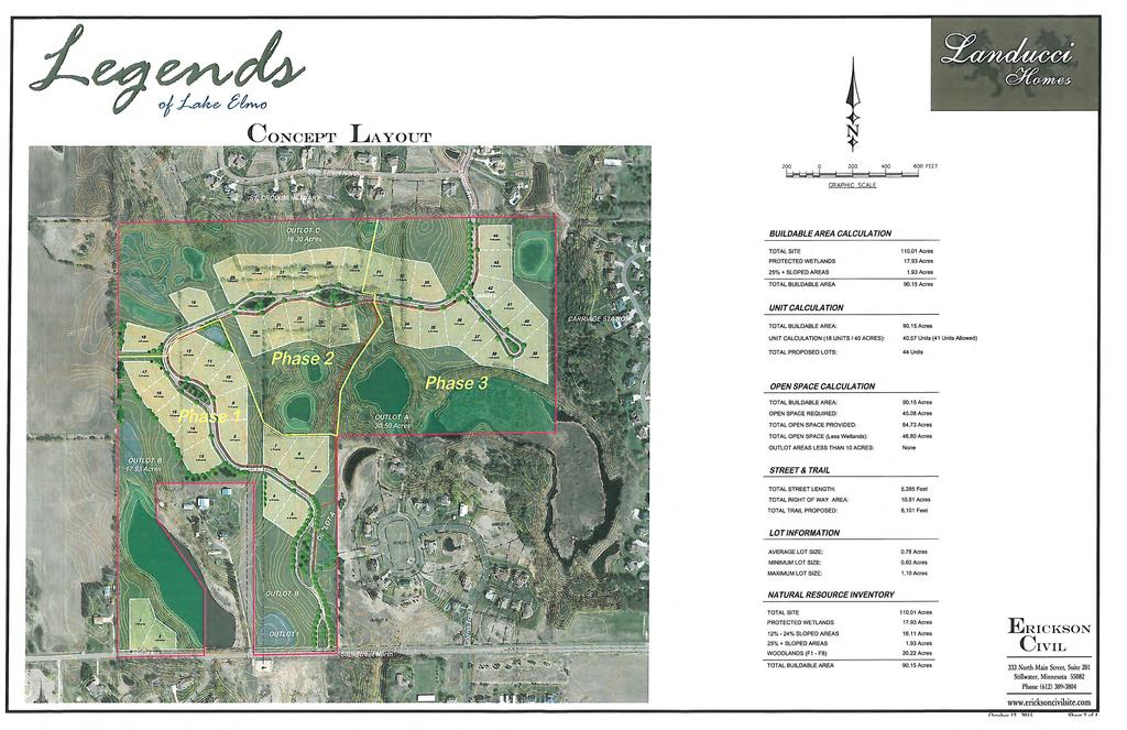
52
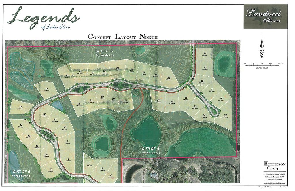
53
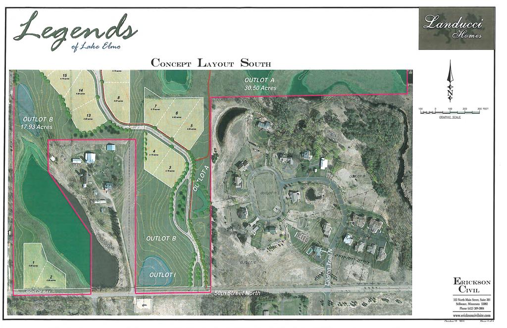
54
City of Lake Elmo Planning Commission Meeting Minutes of August 10, 2015
 City of Lake Elmo Planning Commission Meeting Minutes of August 10, 2015 Chairman Dodson called to order the meeting of the Lake Elmo Planning Commission at 7:00 p.m. COMMISSIONERS PRESENT: Dodson, Dorschner,
Major Subdivision Sketch Plan Checklist
 This checklist provides specific requirements that are apart of the Sketch process. The entire process is described by the Huntersville Subdivision Review Process which details all the submittal and resubmittal
Asbury Chapel Subdivision Sketch Plan
 Asbury Chapel Subdivision Sketch Plan PART 1: PROJECT SUMMARY Applicant: NVR Inc. Project Size: +/- 76.13 acres Parcel Numbers: 02101112,02116101,02116112, 02116113 Current Zoning: Transitional Residential
REQUEST FOR COUNCIL ACTION 6A AGENDA ITEM ORIGINATING DEPT. AGENDA ITEM CITY ADMINISTRATOR APPROVAL
 DATE REQUEST FOR COUNCIL ACTION 6A AGENDA ITEM ORIGINATING DEPT. AGENDA ITEM CITY ADMINISTRATOR APPROVAL Community Development Territorial Greens PUD Concept Plan Development Stage Plan Subdivision (Preliminary
CHAPTER 22 Rural Open Space Community Developments
 CHAPTER 22 Rural Open Space Community Developments Section 22.1 Description and Purpose The intent of this Chapter is to offer property owners an alternative to traditional zoning requirements for rural
Watertown City Council
 City of Watertown Watertown City Council April 14 th, 2015 Agenda Item: City Comment on Sun Share CUP Application Request for Action: Motion to Approve City Comments regarding CUP Application Department:
Exhibit A. 8:9 Scuffletown Rural Conservation District
 Exhibit A 8:9 Scuffletown Rural Conservation District 8:9.1 Intent and Purpose The Scuffletown Rural Conservation (SRC) District is intended to provide for residential development that supports the development
PLANNED UNIT DEVELOPMENT Date: April 5, 2018
 PLANNED UNIT DEVELOPMENT Date: April 5, 2018 DEVELOPMENT NAME SUBDIVISION NAME LOCATION Robert Myers Robert Myers 2955 and 2989 Dauphin Street (Southeast corner of Dauphin Street and Sage Avenue) CITY
RESIDENTIAL PLANNED UNIT DEVELOPMENT / SUBDIVISION AND REZONING CONCEPT AND DEVELOPMENT STAGE PLAN SUBMITTAL NARRATIVE
 RESIDENTIAL PLANNED UNIT DEVELOPMENT / SUBDIVISION AND REZONING CONCEPT AND DEVELOPMENT STAGE PLAN SUBMITTAL NARRATIVE DEVELOPMENT TEAM DONEGAL SOUTH Maple Grove, Minnesota March 27, 2017 Applicant/Developer/Builder:
E. RURAL COMMERCIAL/INDUSTRIAL PARK MODEL
 E. RURAL COMMERCIAL/INDUSTRIAL PARK MODEL 1. PURPOSE The purpose of the Rural Commerce/Industrial Park Model is to provide parameters within which a grouping of business buildings with parking, loading
EXHIBIT B PROJECT NARRATIVE POULSBO MEADOWS
 EXHIBIT B PROJECT NARRATIVE POULSBO MEADOWS Name of Project: Poulsbo Meadows; A Planned Residential Development (PRD)/Plat Applicants Name: PBH Group LLC/Byron Harris PO Box 1010 Silverdale, WA 98038 Description
9 th Street Sub Area Plan
 9 th Street Sub Area Plan In the 1990 s, when the Township prepared the last Master Plan, the 9 th Street corridor was studied as part of a larger 9 th Street Focus Area that included the West Main Street
ARTICLE 6: Special and Planned Development Districts
 ARTICLE 6: Special and Planned Development Districts 6-10 Traditional Neighborhood Development (TND) District 6-10.10 Purpose and Intent The Traditional Neighborhood Development (TND) District provides
PLANNED UNIT DEVELOPMENT & SUBDIVISION STAFF REPORT Date: May 18, 2017
 & PUD-0000102-2017 PLANNED UNIT DEVELOPMENT & SUBDIVISION STAFF REPORT Date: May 18, 2017 NAME SUBDIVISION NAME Dauphin Creek Estates Subdivision Dauphin Creek Estates Subdivision LOCATION CITY COUNCIL
CHUGIAK-EAGLE RIVER SITE-SPECIFIC LAND USE PLAN
 CHUGIAK-EAGLE RIVER SITE-SPECIFIC LAND USE PLAN JUNE 2010 Final Prepared for The Heritage Land Bank, Municipality of Anchorage by Agnew: :Beck Consulting www.agnewbeck.com 907.222.5424 Chugiak-Eagle River
PART 1: PROJECT SUMMARY. Proposed Land Use: 120 single-family lots. The application is Attachment A. The site plan is Attachment B.
 PART 1: PROJECT SUMMARY Applicant: JBH Development, LLC and Hopper Communities, INC Project Size: +/- 80.48 acres Parcel Number: 01513107, 01513108, 01513109, 01513113, 01513120, 01513121, 01513122, 01513124,
Town of Portola Valley General Plan. Nathhorst Triangle Area Plan
 Town of Portola Valley General Plan Amended December 10, 1997 Table of Contents Introduction... 1 Planning Area... 1 Objectives... 2 Principles... 2 Standards... 4 Description... 4 Community Commercial...
AWH REPORT OF THE PLANNING AND DEVELOPMENT DEPARTMENT FOR APPLICATION FOR REZONING ORDINANCE TO PLANNED UNIT DEVELOPMENT
 AWH REPORT OF THE PLANNING AND DEVELOPMENT DEPARTMENT FOR APPLICATION FOR REZONING ORDINANCE TO PLANNED UNIT DEVELOPMENT MAY 8, 2014 The Planning and Development Department hereby forwards to the Planning
Rural Land Use Designations Kittitas County December 6, 2007 Draft
 KITTITAS COUNTY COMMUNITY DEVELOPMENT SERVICES 411 N. Ruby St., Suite 2, Ellensburg, WA 98926 CDS@CO.KITTITAS.WA.US Office (509) 962-7506 Fax (509) 962-7682 Rural Land Use Designations Kittitas County
Gold Line Bus Rapid Transit Transit Oriented Development (BRTOD) Helmo Station Area Plan
 Helmo Station Area Plan") Appendix F Gold Line Bus Rapid Transit Transit Oriented Development (BRTOD) Helmo Station Area Plan Introduction and Purpose of the Plan The Gold Line Bus Rapid Transit facility is an eleven-mile dedicated
Appendix F Gold Line Bus Rapid Transit Transit Oriented Development (BRTOD) Helmo Station Area Plan Introduction and Purpose of the Plan The Gold Line Bus Rapid Transit facility is an eleven-mile dedicated
APPENDIX A 6 CONCEPTUAL PRELIMINARY PLAN GUIDE AND CHECKLIST FOR MAJOR SUBDIVISIONS CARRBORO DEVELOPMENT GUIDE APPENDIX A
 6 CONCEPTUAL PRELIMINARY PLAN GUIDE AND CHECKLIST FOR MAJOR SUBDIVISIONS Conceptual Preliminary Guide/Checklist for Major Subdivisions Page 1 FORM: REVIEW DATE: CONCEPTUAL PLAN REVIEW 2000 REVIEWED BY:
ARTICLE IV: DEVELOPMENT STANDARDS 404 MASTER PLANNING
 IV 13 404 MASTER PLANNING Master Planning through the Site Analysis (Master Planning Site Analysis) or Planned Development (Master Planning Planned Development) is provided to encourage development which
CONSENT CALENDAR CITY PLANNING COMMISSION AGENDA ITEM NO: A.1, A.2 STAFF: LARRY LARSEN
 Page 8 CONSENT CALENDAR CITY PLANNING COMMISSION AGENDA ITEM NO: A.1, A.2 STAFF: LARRY LARSEN FILE NO: CPC PUZ 14-00013 - QUASI-JUDICIAL FILE NO: CPC PUD 14-00014 QUASI-JUDICIAL PROJECT: APPLICANT: OWNER:
Environmental Protection Ordinances (Performance Zoning) Bedminster Township, Bucks County
 Bedminster Township, Bucks County") Environmental Protection Ordinances (Performance Zoning) Bedminster Township, Bucks County ARTICLE VI. PERFORMANCE STANDARDS Section 600 Compliance All uses, activities, subdivisions and/or land developments
Environmental Protection Ordinances (Performance Zoning) Bedminster Township, Bucks County ARTICLE VI. PERFORMANCE STANDARDS Section 600 Compliance All uses, activities, subdivisions and/or land developments
A BILL FOR AN ORDINANCE TO AMEND CHAPTER 9, KAUAI COUNTY CODE 1987, RELATING TO STREET REQUIRE:MENTS FOR SUBDIVISIONS
 ORDINANCE NO. BILL NO. { vy"yj1j A BILL FOR AN ORDINANCE TO AMEND CHAPTER 9, KAUAI COUNTY CODE 1987, RELATING TO STREET REQUIRE:MENTS FOR SUBDIVISIONS BE IT ORDAINED BY THE COUNCIL OF THE COUNTY OF KAUA'I,
THREE-STEP DESIGN PROCESS FOR OPEN SPACE SUBDIVISIONS
 00216106.DOC NMA/RRK 1/30/14 THREE-STEP DESIGN PROCESS FOR OPEN SPACE SUBDIVISIONS Open space subdivisions, sometimes called cluster developments, maintain a significant portion of a development site in
Mitchell Ranch South MPUD Application for Master Planned Unit Development Approval Project Narrative. Introduction
 Mitchell Ranch South MPUD Application for Master Planned Unit Development Approval Project Narrative Introduction Mitchell Ranch South is a proposed single family (detached) residential development on
ROAD CLOSURE AND LAND USE AMENDMENT SILVER SPRINGS (WARD 1) NORTHEAST OF NOSEHILL DRIVE NW AND SILVER SPRINGS ROAD NW BYLAWS 2C2018 AND 29D2018
 NORTHEAST OF NOSEHILL DRIVE NW AND SILVER SPRINGS ROAD NW BYLAWS 2C2018 AND 29D2018") Page 1 of 19 EXECUTIVE SUMMARY This application proposes redesignating two parcels in the community of Silver Springs from Special Purpose Future Urban Development (S-FUD) District and undesignated road
Page 1 of 19 EXECUTIVE SUMMARY This application proposes redesignating two parcels in the community of Silver Springs from Special Purpose Future Urban Development (S-FUD) District and undesignated road
Urban Planning and Land Use
 Urban Planning and Land Use 701 North 7 th Street, Room 423 Phone: (913) 573-5750 Kansas City, Kansas 66101 Fax: (913) 573-5796 Email: planninginfo@wycokck.org www.wycokck.org/planning To: From: City Planning
CITY OF DAYTON Meeting Date: PLANNING COMMISSION
 CITY OF DAYTON Meeting Date: 3-8-18 PLANNING COMMISSION Item: B ITEM: Application by North Diamond Investment, LLC. for Concept Plan Review - Cloquet Island Estates APPLICANTS/PRESENTERS: North Diamond
Chapter 3 Site Planning and Low Impact Development
 CHAPTER 3 Site Planning and Low Impact Development Chapter 3 Site Planning and Low Impact Development 3.0 Introduction The City of Charleston requires that major residential, large commercial (>1 acre),
City of Grande Prairie Development Services Department
 City of Grande Prairie Development Services Department ROYAL OAKS NORTH OUTLINE PLAN OP-07-03 NW 35-71-6 W6M May 7, 2007 Royal Oaks North Outline Plan TABLE OF CONTENTS 1.0 INTRODUCTION........ 3 1.1 Purpose
Baumgarten MPUD. Exhibit 3 Evaluation Criteria
 Pursuant to LDC subsections 10.02.13 B, 10.02.08 F and Chapter 3 G. of the Administrative Code, staff s analysis and recommendation to the Planning Commission, and the Planning Commission s recommendation
PRELIMINARY REPORT. HIGHWAY 18 CORRIDOR NEIGHBORHOOD PLAN VILLAGE OF DOUSMAN November, 2014
 PRELIMINARY REPORT HIGHWAY 18 CORRIDOR NEIGHBORHOOD PLAN VILLAGE OF DOUSMAN November, 2014 This preliminary report presents the initial recommendations for land use within the Highway 18 corridor along
14 October 10, 2012 Public Hearing APPLICANT: MPB, INC
 14 October 10, 2012 Public Hearing APPLICANT: MPB, INC PROPERTY OWNER: MUNDEN & ASSOCIATES, LP STAFF PLANNER: Karen Prochilo REQUEST: Conditional Change of Zoning (AG-1 & AG-2 to Conditional O-2) ADDRESS
CITY OF PORTSMOUTH PLANNING DEPARTMENT. MEMORANDUM To: From:
 CITY OF PORTSMOUTH PLANNING DEPARTMENT MEMORANDUM To: From: Subject: Date: Planning Board Juliet T.H. Walker, Planning Director Jillian Harris, Planner 1 Staff Recommendations for the August 23, 2018 Planning
Land Use Amendment in Southwood (Ward 11) at and Elbow Drive SW, LOC
 at and Elbow Drive SW, LOC") 2018 November 15 Page 1 of 10 EXECUTIVE SUMMARY This land use amendment application was submitted by Rick Balbi Architect on 2017 August 31 on behalf of Sable Developments Ltd, and with authorization from
2018 November 15 Page 1 of 10 EXECUTIVE SUMMARY This land use amendment application was submitted by Rick Balbi Architect on 2017 August 31 on behalf of Sable Developments Ltd, and with authorization from
City of Grande Prairie Development Services Department KENNEDY DEVELOPMENTS LTD. OUTLINE PLAN OP-09-01
 City of Grande Prairie Development Services Department KENNEDY DEVELOPMENTS LTD. OUTLINE PLAN OP-09-01 July 27, 2009 TABLE OF CONTENTS 1.0 Introduction... 1 1.1 Plan Area Location & Context... 1 1.2 Ownership
SUBDIVISION, PLANNED UNIT DEVELOPMENT, PLANNING APPROVAL, REZONING & SIDEWALK WAIVER STAFF REPORT Date: February 7, 2013
 SUBDIVISION, PLANNED UNIT DEVELOPMENT, PLANNING APPROVAL, REZONING & SIDEWALK WAIVER STAFF REPORT Date: February 7, 2013 APPLICANT NAME SUBDIVISION NAME DEVELOPMENT NAME LOCATION S. E. Cemeteries of AL
Community Development Rezoning Report REZ14-006
 Community Development Rezoning Report REZ14-006 Planning Commission Board of Supervisors March 4, 2014 March 26, 2014 Applicant M & N Real Estate, LLC Tax Map Id 125-(A)- L20E,125-(A)- L20E1, portion of
OP Council Resolution June 16, Planning and Development Services
 OP-08-01 Council Resolution June 16, 2008 Planning and Development Services Kingsgate Landing Outline Plan Table of Contents 1.0 Introduction 1 1.1 Purpose of Plan 1 1.2 Plan Area Location 1 1.3 Ownership
REQUEST FOR COUNCIL ACTION 6A AGENDA ITEM
 DATE REQUEST FOR COUNCIL ACTION 6A AGENDA ITEM ORIGINATING DEPT. AGENDA ITEM CITY ADMINISTRATOR APPROVAL Community Development PUD Concept & Development Stage Plan Preliminary Plat & Final Plat PREVIOUS
Sanford/Lee County Technical Review Committee (TRC) DEADLINES & MEETING DATES
 DEADLINES & MEETING DATES") Sanford/Lee County Technical Review Committee (TRC) DEADLINES & MEETING DATES The following 2019 information is based on the information available to staff at the time of creation. Dates & time may change
Sanford/Lee County Technical Review Committee (TRC) DEADLINES & MEETING DATES The following 2019 information is based on the information available to staff at the time of creation. Dates & time may change
Draft CHAPTER TWO THREE LAND USE PLAN
 CHAPTER TWO THREE LAND USE PLAN LAND USE PLAN The basic intent of the comprehensive planning process is to provide a well-founded and coordinated decision-making framework to guide both public and private
PLANNED UNIT DEVELOPMENT & SUBDIVISION STAFF REPORT Date: March 15, 2012
 PLANNED UNIT DEVELOPMENT & SUBDIVISION STAFF REPORT Date: March 15, 2012 DEVELOPMENT NAME SUBDIVISION NAME LOCATION OSR Subdivision OSR Subdivision 5559 Old Shell Road (South side of Old Shell Road, 570
NEW CASTLE COUNTY S ZONING DISTRICTS
 NEW CASTLE COUNTY S ZONING DISTRICTS This is general information about New Castle County s zoning districts. The information included is by no means exhaustive or complete. Before designing plans to develop
Application Number: SD Project Name: Walton Farms Preliminary Subdivision (acting as Master Plan)
") STAFF REPORT Town of Clayton Planning Department 111 E. Second Street, Clayton, NC 27520 P.O. Box 879, Clayton, NC 27528 Phone: 919-553-5002 Fax: 919-553-1720 Planning Board May 22, 2017 Application Number:
STAFF REPORT Town of Clayton Planning Department 111 E. Second Street, Clayton, NC 27520 P.O. Box 879, Clayton, NC 27528 Phone: 919-553-5002 Fax: 919-553-1720 Planning Board May 22, 2017 Application Number:
The Maryland-National Capital Park and Planning Commission Prince George's County Planning Department Development Review Division
 The Maryland-National Capital Park and Planning Commission Prince George's County Planning Department Development Review Division 301-952-3530 Note: Staff reports can be accessed at www.mncppc.org/pgco/planning/plan.htm.
CITY OF VACAVILLE PLANNING COMMISSION Agenda Item No. G.1 STAFF REPORT February 21, 2012 BRIGHTON LANDING SPECIFIC PLAN & DEVELOPMENT PROJECT
 CITY OF VACAVILLE PLANNING COMMISSION Agenda Item No. G.1 STAFF REPORT February 21, 2012 Staff Contact: Fred Buderi (707) 449-5307 TITLE: PURPOSE: BRIGHTON LANDING SPECIFIC PLAN & DEVELOPMENT PROJECT INFORMATIONAL
12 January 12, 2011 Public Hearing APPLICANT: TAILWIND DEVELOPMENT GROUP,LLC PROPERTY OWNER: CITY OF VIRGINIA BEACH
 12 January 12, 2011 Public Hearing APPLICANT: TAILWIND DEVELOPMENT GROUP,LLC PROPERTY OWNER: CITY OF VIRGINIA BEACH STAFF PLANNER: Faith Christie REQUEST: Conditional Change of Zoning (from PD-H1 Planned
IV. Development in the Rural Overlay District
 Intracoastal Waterway Route 17 Route 168 Great Dismal Swamp VIRGINIA NORTH CAROLINA IV. Development in the Rural Overlay District IV-1 Route 17 in Chesapeake s Rural Overlay District affords distant views
PLANNING COMMISSION Work Session Meeting Agenda
 PLANNING COMMISSION Work Session Meeting Agenda 5200 85TH AVENUE NORTH BROOKLYN PARK MN 55443 PHONE (763) 424-8000 FAX (763) 493-8391 Wednesday, September 27, 2017-7:00 P.M. Brooklyn Township Room If due
USA Addition of South & East Side Residential Parcels. USA Deletion of a Town of Christiana Parcel. Conversion from USA to Limited Service Area
 Village of Rockdale Village of Rockdale 148 Water Street Cambridge, WI 53523 Phone 608.423.1497 Fax 608.423.9694 Urban Service Area (USA) Amendment USA Addition of South & East Side Residential Parcels
Planning Commission Staff Report June 5, 2008
 Owner/Applicant Taylor Village Sacramento Investments Partners, LP c/o Kim Whitney 1792 Tribute Road #270 Sacramento, CA 95815 Staff Recommendation Planning Commission Staff Report Project: File: Request:
PRELIMINARY CONDITIONAL USE SUBMITTAL CHECKLIST REQUIREMENTS
 This checklist must accompany your submittal as the cover page. CONDITIONAL USE Application Submittal Checklist for PRELIMINARY AND FINAL APPROVAL Per Winter Park Land Development Code Sec. 58-90 PRELIMINARY
Approved: CITY OF ARDEN HILLS, MINNESOTA PLANNING COMMISSION WEDNESDAY, AUGUST 5, :30 P.M. - ARDEN HILLS CITY HALL
 Approved: CITY OF ARDEN HILLS, MINNESOTA PLANNING COMMISSION WEDNESDAY, AUGUST 5, 2015 6:30 P.M. - ARDEN HILLS CITY HALL PLANNING CASES A. Planning Case 15-016; Final Planned Unit Development Arden Plaza;
ROLL CALL Member Anthony, Member Avdoulos, Member Greco, Member Lynch, Member Maday, Chair Pehrson
 CALL TO ORDER The meeting was called to order at 7:00 PM. PLANNING COMMISSION ACTION SUMMARY CITY OF NOVI Regular Meeting July 11, 2018 7:00 PM Council Chambers Novi Civic Center 45175 W. Ten Mile (248)
DCA , Stormwater Quality and Facilities Ordinance June 23, 2009
 PROPOSED NEW SECTION 10.486 Stormwater Quality and Detention Facilities, Public Streets. A. Purpose. It is the City s policy to maintain the natural hydrology and preserve water quality by mitigating the
Planned Residential Neighborhoods Land Use Goals
 Planned Residential Neighborhoods Land Use Goals Issue: Guidelines that provide for diverse high quality residential areas that include a variety of housing styles and layouts are needed. Goal 1: Create
Town of Windham. Planning Department 8 School Road Windham, ME voice fax
 Town of Windham Planning Department 8 School Road Windham, ME 04062 voice 207.864-5960 fax 207.892.1916 MEMO DATE: TO: Staff Review Committee FROM: Amanda Lessard, Planner Cc: Ellen Rathbone, St. Germain
PART 1: PROJECT SUMMARY. The application is Attachment A. The site plan is Attachment B.
 Belleterre Subdivision Sketch Plan Town Board 8.7.17 Belleterre Subdivision Sketch Plan PART 1: PROJECT SUMMARY Applicant: Bowman Development Project Size: +/- 20.85 acres Parcel Number: 01115104 and 01115121
Section 9 NEIGHBORHOOD DESIGN
 Section 9 NEIGHBORHOOD DESIGN City of Lancaster Comprehensive Plan D u n k i n, S e f k o & A s s o c i a t e s, I n c. NEIGHBORHOOD DESIGN INTRODUCTION There are many ways in which a neighborhood can
PLANNED UNIT DEVELOPMENT PUD For The Proposed Antietam Subdivision Escambia County, Florida. Introduction
 PLANNED UNIT DEVELOPMENT PUD For The Proposed Antietam Subdivision Escambia County, Florida Introduction The project is located in Escambia County approximately 0.75 + miles north of the US Highway 90,
FORMER CANADIAN FORCES BASE (CFB) ROCKCLIFFE SECONDARY PLAN. Official Plan Amendment XX to the Official Plan for the City of Ottawa
 ROCKCLIFFE SECONDARY PLAN. Official Plan Amendment XX to the Official Plan for the City of Ottawa") FORMER CANADIAN FORCES BASE (CFB) ROCKCLIFFE SECONDARY PLAN Official Plan Amendment XX to the Official Plan for the City of Ottawa 1 INDEX THE STATEMENT OF COMPONENTS PART A THE PREAMBLE PAGE Purpose...
FORMER CANADIAN FORCES BASE (CFB) ROCKCLIFFE SECONDARY PLAN Official Plan Amendment XX to the Official Plan for the City of Ottawa 1 INDEX THE STATEMENT OF COMPONENTS PART A THE PREAMBLE PAGE Purpose...
ARTICLE 13 STREETS General
 ARTICLE 13 STREETS 13.1 General Streets shall be designed to suit their functions. Many streets have purposes other than vehicular traffic. As an alternative to current N.C. Department of Transportation
Checklists. Project Name: Location: File Number: Date of Submittal: Reviewer: Date: Applicant: Contact Name: Phone Number:
 Applicant: Contact Name: Phone Number: Email: Project Name: Location: File Number: Date of Submittal: Reviewer: Date: Concept Plan Requirements: I. General Project Information 1. Address or parcel number
COLVER ROAD INDUSTRIAL CONCEPT PLAN
 COLVER ROAD INDUSTRIAL CONCEPT PLAN A CONCEPTUAL LAND USE AND TRANSPORTATION PLAN FOR TA-4 AN URBAN RESERVE AREA OF THE CITY TALENT City of Talent Adopted by City Council Resolution No., June, 2015 PART
Transportation Systems and Utility Infrastructure
 77 Audience Local and regional units of government, Landowners and developers, Community and citizen organizations, and Transportation/utility planners and engineers. Overview Transportation systems and
Urban Planning and Land Use
 Urban Planning and Land Use 701 North 7 th Street, Room 423 Phone: (913) 573-5750 Kansas City, Kansas 66101 Fax: (913) 573-5796 Email: planninginfo@wycokck.org www.wycokck.org/planning To: From: Board
CITY OF ROHNERT PARK CITY COUNCIL AGENDA REPORT
 Mission Statement We Care for Our Residents by Working Together to Build a Better Community for Today and Tomorrow. CITY OF ROHNERT PARK CITY COUNCIL AGENDA REPORT ITEM NO. 5 Meeting Date: July 23, 2013
MINUTES OF THE TOWN COUNCIL MEETING SEPTEMBER 1, 2016
 MINUTES OF THE TOWN COUNCIL MEETING SEPTEMBER 1, 2016 Town Council Meeting 09/20/16 Item #1 The Town Council of the Town of Los Gatos conducted a Special Meeting on Thursday, September 1, 2016, at 6:00
CITY OF APPLE VALLEY PLANNING COMMISSION MINUTES SEPTEMBER 18, 2013
 PLANNING COMMISSION MINUTES SEPTEMBER 18, 2013 1. CALL TO ORDER The City of Apple Valley Planning Commission meeting was called to order by Chair Melander at 7:00 p.m. Members Present: Tom Melander, Ken
PLANNED UNIT DEVELOPMENT STAFF REPORT Date: June 2, 2016
 # 9 ZON2016-01032 PLANNED UNIT DEVELOPMENT STAFF REPORT Date: June 2, 2016 DEVELOPMENT NAME JJT Properties LLC LOCATION 1147 & 1151 East I-65 Service Road South and 1180 Sledge Drive (Southeast corner
COMMISSION ACTION FORM
 ITEM #: 6 DATE: 09-06-17 COMMISSION ACTION FORM REQUEST: Introduction and Initial Review of Proposed Amendments to the Ames Urban Fringe Future Land Map for the North Growth Gap Area BACKGROUND INFORMATION:
Outline Plan in Belvedere (Ward 9) at Street SE, LOC (OP)
 at Street SE, LOC (OP)") 2018 October 04 Page 1 of 12 EXECUTIVE SUMMARY This outline plan application was submitted by B&A Planning Group on 2016 July 15, on behalf of Tristar Communities Inc. for 50.14 hectares (123.89 acres)
2018 October 04 Page 1 of 12 EXECUTIVE SUMMARY This outline plan application was submitted by B&A Planning Group on 2016 July 15, on behalf of Tristar Communities Inc. for 50.14 hectares (123.89 acres)
Bostwick Road. Municipal Class Environmental Assessment. Public Information Centre #2 June 14, City of London
 Bostwick Road Municipal Class Environmental Assessment Public Information Centre #2 June 14, 2017 Welcome! Welcome to the 2 nd Public Information Centre for the. Representatives from the and the consulting
R E S O L U T I O N. Single-Family Residence/ Church. 2,488 sq. ft. 2,488 sq. ft. Area Parking Required: Church
 R E S O L U T I O N WHEREAS, the Prince George s County Planning Board is charged with the approval of Detailed Site Plans pursuant to Part 3, Division 9 of the Zoning Ordinance of the Prince George s
KASPER. City of Georgetown, Texas PUD Planned Unit Development. December 30, 2015 Revised January 27, 2016
 KASPER City of Georgetown, Texas PUD Planned Unit Development December 30, 2015 Revised January 27, 2016 Applicant: Sentinel Land Company, LLC 4910 Campus Drive Newport Beach, CA Prepared by: SEC Planning
4.500 Preston Road Overlay District
 Section 4.500 Preston Road Overlay District 2004 Zoning Ordinance 4.500 Preston Road Overlay District (ZC 98-29; Ordinance No. 98-9-12) 4.501 Purpose To provide appropriate design standards for the use
VILLAGE OF CLEMMONS PLANNING BOARD DRAFT STAFF REPORT
 VILLAGE OF CLEMMONS PLANNING BOARD DRAFT STAFF REPORT PETITION INFORMATION Docket # C-226 Staff Megan Ledbetter Petitioner(s) JBJH Properties, LLC Owner(s) JBJH Properties, LLC Subject Property 5892-49-1766
CITY OF ZEELAND PLANNING COMMISSION
 APPLICATION FOR SITE PLAN REVIEW AND SPECIAL LAND USE Date City Official App. Filing Fee Rec'd ($350) NOTE TO APPLICANT: Please submit this application for Site Plan Review along with twenty (20) copies
Chapter 5: Natural Resources and Environment
 NATURAL RESOURCES AND ENVIRONMENT 5-1 5 Chapter 5: Natural Resources and Environment BACKGROUND AND INTENT Urban expansion represents the greatest risk for the future degradation of existing natural areas,
Green Oak Charter Township. Planning Commission Regular Meeting Minutes August 4, 2016
 1 2 3 4 5 6 7 8 9 10 11 12 13 14 15 16 17 18 19 20 21 22 23 24 25 26 27 28 29 30 31 32 33 34 35 36 37 38 39 40 41 42 43 44 45 46 47 48 49 Planning Commission Regular Meeting Minutes August 4, 2016 The
CITY PLANNING COMMISSION AGENDA ITEM: C STAFF: ROBERT TEGLER FILE NO: CPC PUD QUASI-JUDICIAL
 CPC AGENDA June 8, 2006 Page 37 CITY PLANNING COMMISSION AGENDA ITEM: C STAFF: ROBERT TEGLER FILE NO: CPC PUD 05-294 - QUASI-JUDICIAL PROJECT: APPLICANT: OWNER: PARKWOOD AT WOLF RANCH NASS DESIGN ASSOCIATES
13. PRELIMINARY PLAT NO MILLS FARM - Vicinity of the southeast corner of 159 th Street and Quivira Road
 13. corner of 159 th Street and Quivira Road 1. APPLICANT: HNTB Corporation is the applicant for this request. 2. REQUESTED ACTION: The applicant is requesting approval of a preliminary plat for a 383-lot
2.0 AREA PLANS. Lakeside Business District. Lakeside Business District Land Use Categories:
 Lakeside Business District Lakeside Business District Land Use Categories: Campus Commercial Campus Commercial means a mixture of uses which includes corporate offices, office parks, hotels, commercial,
Table IX-1 LAND USES IN WASHINGTON COUNTY: 2006
 #128550 v1 - WASH CO CP TBL I-1 2006 LU NMA/RLR 12/21/07 Table I-1 LAND USES IN WASHINGTON COUNTY: 2006 Note: This table, and the accompanying map, is more general than the land use inventory conducted
Description of Preferred Alternative
 Chapter 2 Description of Preferred Alternative 2.1 Introduction This chapter of the programmatic Sammamish Town Center Sub-area Plan Final EIS provides a more detailed description of the Preferred Alternative
ARLINGTON COUNTY, VIRGINIA. County Board Agenda Item Meeting of February 23, 2019
 ARLINGTON COUNTY, VIRGINIA County Board Agenda Item Meeting of February 23, 2019 DATE: February 15, 2019 SUBJECT: Amendment to the Master Transportation Plan (MTP) Map to add a new section of North Kansas
PROJECT BACKGROUND. Preliminary Design Scope and Tasks
 PROJECT BACKGROUND Preliminary Design Scope and Tasks The purpose of this Study is the development of preliminary designs for intersection improvements for Trunk Highway (TH) 36 at the intersections of
CONCEPT PLAN APPLICATION
 CONCEPT PLAN APPLICATION TOWN OF CHAPEL HILL Planning Department 405 Martin Luther King Jr. Blvd phone (919) 968-2728 fa (919) 969-2014 www.townofchapelhill.org Parcel Identifier Number (PIN): 9880267455
Michael D, Harvey, Current Planning Supervisor. This project was originally approved in 2012 by the BOCC and is summarized as follows:
 PLANNING & INSPECTIONS DEPARTMENT Craig N. Benedict, AICP, Director Current Planning (919) 245-2575 (919) 644-3002 (FAX) www.orangecountync.gov 131 W. Margaret Lane Suite 201 P. O. Box 8181 Hillsborough,
City of Tacoma Planning and Development Services
 Agenda Item D-3 City of Tacoma Planning and Development Services To: Planning Commission From: Stephen Atkinson, Associate Planner, Planning Services Division Subject: Land Use Designations - Phase 2 Meeting
LAND USE AMENDMENT CORNERSTONE (WARD 3) 60 STREET NE AND COUNTRY HILLS BOULEVARD NE MAP 26NE BYLAW 22D2017
 60 STREET NE AND COUNTRY HILLS BOULEVARD NE MAP 26NE BYLAW 22D2017") Page 1 of 14 EXECUTIVE SUMMARY This Land Use Amendment application covers an area of 43.76 hectares ± (108.14 acres ±) located in northeast Calgary, bound by Country Hills Boulevard NE to the south and
Page 1 of 14 EXECUTIVE SUMMARY This Land Use Amendment application covers an area of 43.76 hectares ± (108.14 acres ±) located in northeast Calgary, bound by Country Hills Boulevard NE to the south and
Section 4 BUILDING THE MASTER PLAN
 The Master Plan 33 Section 4 BUILDING THE MASTER PLAN Figure 4:1. A collaborative effort characterized the two design workshops sponsored by DISC to create hypothetical Master Plans for the Towers Property
City of Redmond. Urban Holding Area Master Planning Requirements and Approval Process
 City of Redmond Urban Holding Area Master Planning Requirements and Approval Process June 21, 2006 City of Redmond: Urban Holding Area Master Planning Requirements and Approval Process Table of Contents
RFP REQUEST FOR PROPOSALS CITY OF PORTSMOUTH, NH. DESIGN ENGINEERING SERVICES North Mill Pond Trail and Greenway
 RFP 61-18 REQUEST FOR PROPOSALS CITY OF PORTSMOUTH, NH DESIGN ENGINEERING SERVICES North Mill Pond Trail and Greenway Sealed Requests for Proposals, plainly marked RFP 61-18 Design Engineering Services
LAND USE AMENDMENT DOWNTOWN COMMERCIAL CORE (WARD 7) MACLEOD TRAIL SE AND 5 AVENUE SE BYLAW 254D2017
 MACLEOD TRAIL SE AND 5 AVENUE SE BYLAW 254D2017") Page 1 of 10 EXECUTIVE SUMMARY This Land Use Amendment application seeks to redesignate a full downtown block (currently the YWCA site) from a Direct Control based on the CM-2 District (Land Use Bylaw
Page 1 of 10 EXECUTIVE SUMMARY This Land Use Amendment application seeks to redesignate a full downtown block (currently the YWCA site) from a Direct Control based on the CM-2 District (Land Use Bylaw
ARTICLE 17 SITE PLAN REVIEW
 ARTICLE 17 SITE PLAN REVIEW 17.01 INTENT AND PURPOSE The intent of this section is to provide for consultation and cooperation between the applicant and the township planning commission so that the applicant
Town of Washington Master Plan & Regulatory Audit: Interim Results
 Town of Washington Master Plan & Regulatory Audit: Interim Results May 20, 2008 Presented by: 30 Bank Street Lebanon, NH 03766 www.uvlsrpc.org Introduction & Purpose Compare the Master Plan to the regulations