heuston gateway: scope and context
|
|
|
- Nathan French
- 5 years ago
- Views:
Transcription

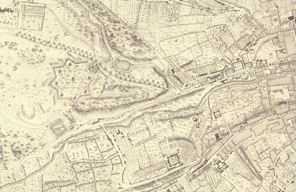
1 suburban rail DART (proposed by DTO) LUAS (under construction) 1000 metre radius QBC Heuston Gateway: public transport heuston gateway: scope and context 33

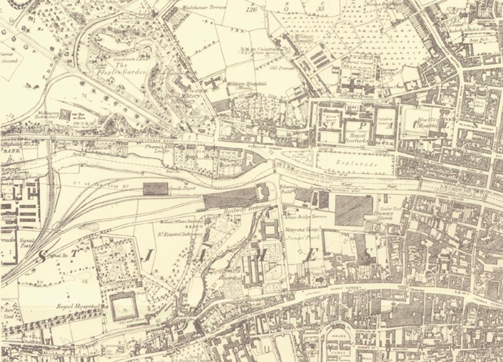
2 Heuston Gateway: private transport survey urbanprojects 34
3 2.1.4 image and perception Many of the individual buildings distributed throughout the area are memorable and recognisable, with imposing classical facades and elevated or set-back positions. These buildings provide the main memory of the site and are of national symbolic importance, conveying messages about the culture and state of the nation particularly the National Museum and the Irish Museum of Modern Art. The key focal point of the area is the station, which by its nature is a uniquely emotive building type, associated with holidays, domestic and career change, separations and reunions. The famous views into and around the station environs do not portray the actual physical experience of being in the public domain in the study area. Many of the landmarks provide points of reference that aid orientation through the city, such as the Wellington Monument, the Royal Hospital spire and the Guinness works. The industrial buildings on the Guinness lands also provide a powerful image of the city. There is an awareness of topography in the study area the the central space of the area is no longer defined by the buildings along the quays, but by the slopes of the river valley. Considering the Liffey runs straight through the study area it makes little impact on the experience of the site, mainly due to the confined and congested nature of the public domain and walls to the river. Memorial Gardens heuston gateway: scope and context 35 35

4 Heuston Gateway: orientation survey urbanprojects 36 36
5 2.1.5 landscape The study area is unusual for central Dublin in that it is dominated by a very distinct topography, with land rising significantly on either side of the river. Dublin is perceived as a generally flat city, with any undulation moderated or partially disguised by the dense urban fabric. The study area is an exception to this with the Park and Montpelier Hill to the north and James Street and the Royal Hospital Kilmainham to the south. The topography of the river valley is integral to the intensity of views and image of the area and should be a core consideration of any strategy for development in the area. Topography has a major effect on decisions relating to: views building height potential for linkages visual and physical light Four sections, measured photometrically, have been recorded as shown overleaf. The section lines are positioned to examine 4 key topographic configurations and conditions across the site illustrating the potential and differences within the area. a b c d Heuston - Phoenix park Heuston - IMMA North bank to Heuston Heuston to Montpelier Hill a b c d heuston gateway: scope and context 37
6 survey urbanprojects 38

.")
7 2.1.6 building height distribution elevated classical facades: The study "Managing Intensification and Change; A strategy for Dublin Building Height", discussed in a later section, highlights the Heuston Station lands and the Guinness lands as areas for potential building height and density. Existing height distribution is most concentrated in the area of the Guinness lands near James Street. The major cultural institutions are still relatively tall and imposing buildings, often using the topography to great effect - such as the Wellington Monument, Royal Hospital Kilmainham (IMMA), the Department of Defence Headquarters and the Collins Barracks (National Museum). a b c d e f g RHK/ IMMA Collins Barracks Department of Defence headquaters height precedents at Guinness Barley Flaking building view from Collins Barracks DEGW diagrams potential landmark locations for high buildings potential location for high density clusters f g a b c d e heuston gateway: scope and context 39
8 2.1.7 views: The image of Dublin is very much reliant on views the James Malton aquatints are an example. Many of the individual notable buildings in the study area are set up on views, either on an axis with perfect symmetry in the façade, or in a picturesque, romantic situation. There are no officially protected views in Dublin. The following images are suggestions of the important views for consideration in the study area. It will be necessary in the Development Framework Plan for the overall area to identify and prioritise a limited number of views and ensure they are not adversely affected by any future development. a b c d malton view from magazine fort monument to and from IMMA view of monument from quays view of Guinness from Chesterfield a b c d survey urbanprojects 40
9

10 2.2 CONSERVATION AND ARCHAEOLOGY Development Phases The study area lies to the west of the City Centre and has evolved through many historical periods. It is included within the zone of archaeological interest which protects the original settlement of the City. Its character is a compound of the various layers of development from earliest times to the present day and each period has contributed to its evolution. Several distinct stages in the development of the area may be identified:- Late Viking/Early Medieval - There is evidence on the western side of the Royal Hospital of the occupations of the Viking and early Christian period. 17th 18th Century - The laying out of the Barracks and Royal Hospital on the northern and southern sides of the Liffey and the laying out of the Phoenix Park. 18th Century The building of St Patrick s and Steevens Hospital. 19th Century The arrival of the railway and the construction of Kingsbridge Station, the laying out and consolidation of Guinness Brewery and the Royal Phoenix Ironworks. Guinness, St James Gate, century 20th Century The decline in the use of former Barracks and their adoption to other uses. The infill and re-development of areas of dereliction, particularly along Bow Lane and Conyngham Road. survey urbanprojects 42
11
12 2.2.2 Street Layout The street layout derives from the medieval pattern largely formed by roads along or connecting the Rivers Liffey and Cammock with significant crossing points at Bloody Bridge (Rory O Moore Bridge) on the Liffey and Bow Bridge on the Cammock. The layout of the streets of the Study Area are today much as they were at the beginning of the 19th century. The main interventions are: Significant Structures The area abounds in protected structures including Wellington Testimonial and Kilmainham Gaol which impinge visually on the area. In addition to these, the Study Area abounds in unlisted local artefacts and structures of significance which contribute to the character of the area and whose protection should be assured. The removal of Long Lane which linked Bow Bridge and Islandbridge Road to the east of the Royal Hospital to facilitate the railway and which was replaced by Military Road, (a private road up to then.) The removal of Cookes Lane and Lord Galways Walk to facilitate the expansion of Guinnesses. The removal of Flood Street and Liffey Street to create the Esplanade in front of the Royal Barracks. Several former street names such as Murdering Lane and Cutthroat Lane have been lost. survey urbanprojects 44
13
14 2.3 MOVEMENT AND ACCESS introduction: existing / proposed transportation infrastructure This section describes the existing transportation infrastructure in the study area in the context of the accessibility through the area as well as connectivity with surrounding Integrated Action Plan areas, the City Centre and the rest of the country in general. The role of the Heuston Station as a public transport node will also be set out along with proposed highways and public transport service improvements for the area. A considerable number of studies relating to planning, transportation, regeneration and economic development etc. have been undertaken over the past number of years for locations surrounding the study area. The transportation proposals arising from these studies will be described and their effects on the operation of the transportation network within the Heuston Area discussed. The area is also characterised by a high level of pedestrian movements relating to the public transport provision. However there is limited pedestrian connectivity to the surrounding areas and the existing pedestrian environment is far from ideal. This section of the report will identify the major generators of pedestrian movement along with the primary pedestrian desire lines through the area. The opportunity to provide improved routes in terms of safety and aesthetics will be discussed in this document. The existing parking policies, parking availability as well as the existing and predicted modal split within the study area will be set out. survey urbanprojects 46
15 2.3.2 existing infrastructure The main roads through the Heuston Gateway can summarised as follows: East/West Routes: Conyngham Road / Parkgate Street / Wolfe Tone Quay / Ellis Quay Ushers Island / Victoria Quay / St Johns Road West Thomas Street / James Street / Bow Lane North / South Routes: Blackhall Place Watling Street Military Road Steevens Lane Infirmary Road South Circular Road The main east/west routes of N4 St Johns Road, Conyngham Road, Parkgate Street and the North and South Quays dominate the existing highway network in the study area. These routes connect the western suburbs of Dublin such as Palmerstown, Lucan and beyond to the City Centre. Traffic levels on the east/west roads far exceed volumes on the remainder of the network within the study area, with the north/south routes generally being found to the periphery of the area. St Johns Road West and the Quays form part of the N4 National Primary Route which connects the city centre to the M50 at Clondalkin and beyond to such destinations as Sligo (N4), Westport (N5) and Galway (N6). The annual average daily traffic on the road (AADT) exceeds 40,000 vehicles (two-way) in the city centre. The average percentage of HGVs on this route is approximately 17% according to the NRA s National Roads and Traffic Flows 1997 document. It is likely that this percentage content will have increased as a result of the sharp growth in Ireland s economic performance over the intervening years. There are issues of concern in relation to the capacity of the network at a number of locations on the study area road network. The majority of routes in the study area, particularly the quays, are characterised by long delays and traffic congestion resulting in severe environmental degradation, significant impact in the trade activity on the various roads and streets, unsatisfactory conditions for pedestrian and cyclists, and unacceptable levels of noise and air pollution in the area. The traffic congestion on the northern quays also severely reduces the effectiveness of the Quality Bus Corridor. A number of minor north/south routes are found in the study area, with the South Circular Road and Blackhall Place, both of which define the western and eastern boundaries of the study area respectively, carrying the most significant volumes of traffic. Military Road connects Bow Lane and Kilmainham Lane to St John s Road immediately west of Heuston Station. Steevens Lane is to accommodate the the LUAS Light Rail Line A, from Tallaght to Abbey Street. Following discussions with Dublin City Council and the Light Rail Projects office, it has been established that this route will be closed to vehicular traffic in the long term with the exception of access traffic. heuston gateway: scope and context 47
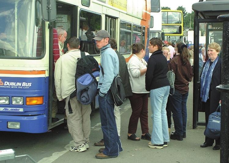
16 2.3.3 public transport infrastructure The most significant element of the public transport service in the study area is Heuston Station. This Railway station connects Dublin with all major destinations in the South and West of Ireland, as well as operating as the terminus for the Arrow Service to Kildare Town and all stops in between. This service has developed into an important commuter route for people working in Dublin City Centre with significant passenger volumes at peak hours. Heuston Station is served by Dublin Bus services to the city centre and key destinations. A number of dedicated shuttle bus services connect Heuston Station with such destinations as Connolly Station, Dublin Airport, IFSC, DART stations and the city centre. A number of routes serving the suburbs of Dublin also terminate or call at Heuston Station. The majority of public transport services in the area use the Quality Bus Corridors on either side of the quays, with a number of services also using the routes on Thomas Street. The study area is traversed by a number of other important routes connecting Dublin City Centre to outlying parts of the city. The Dublin Bus routes which serve Heuston Station are summarised below: 25X Lucan to Belfield 26 Wellington Quay to Cherry Orchard 46A Heuston to Belfield (infrequent service) 51 City Centre to Neilstown 51X Dunawley to Waterloo Road 66X Maynooth to Belfield 67X Celbridge to Belfield 69X Rathcoole to Aston Quay 747/8 Heuston Station to Airport 79 Aston Quay to Ballyfermot 90 Heuston Station to Connolly Station and City Centre survey urbanprojects 48
17
18 2.3.4 parking At present the majority of public parking in the study area is located on street, with a large commuter car park located at Heuston Station. Employment centres such as Guinness, Eircom etc. provide a level of private car parking for employees. Areas such as the Phoenix Park and locations to the North of the study area are sometimes used as informal park and ride locations, in order to avoid expensive parking charges in the Central Business District significant trip generators A number of significant trip generators are to be found within the Heuston Study area, with Heuston Station itself the largest. Large numbers of people use the station throughout the day, with very significant percentages arriving or departing by foot or by bus. One of the unique characteristics of the study area is the number of important tourist destinations and national institutions located throughout the area such as the National Museum at Collins Barracks, the Royal Hospital Kilmainham and the Guinness Storehouse. The vast majority of tourists access these destinations on foot or via tourist trail buses which operate frequently from the city centre, bringing tourists to key locations throughout Dublin. Other significant generators in or close to the study area include large employers such as Guinness UDV, Eircom, ERHA and St James Hospital, all of which contribute to the amount of traffic on the road network. survey urbanprojects 50

19 2.3.6 Dublin City Council s strategic cycle network plan Cycling is one of the key elements of the DTI Strategy Report. Despite the low levels of priority and road space allocated, cyclists account for approximately 5% of all peak hour travel to the City Centre. This report summarises a number of detailed studies undertaken by the Environmental Traffic Planning Division along with the public consultation exercise which has resulted in plans for a Strategic Cycle Network of approximately 160kms within the City Council area. ETP puts forward a number of arguments for the increased use of bicycles such as the benefits in terms of health and the effect on traffic should the percentage of persons cycling increase to over 10%. The proposed strategic cycle network is shown opposite. The DTI report also details mechanisms for finance and implementation of the network. Within the Heuston Gateway the key cycle routes proposed include St Johns Road, the north and south Quays, Conyngham Road, Thomas Street and Bow Lane. The main cycle routes including the Quays have been constructed. Work is on-going on other routes throughout the city. heuston gateway: scope and context 51

20 The main point of conflict for pedestrians is located at the junction of St Johns Road West, Heuston Station and Frank Sherwin Bridge. This junction is unsafe for pedestrians as can be observed by the number of accidents with the guardrails on the refuge islands in the centre of the junction. Heuston Station is the main pedestrian trip generator in the study area. Pedestrian surveys undertaken at the entrances to the train station between 07:30 and 09:30 showed some 2356 persons exiting the station of which 73% boarded a bus, the remainder walking to their destination. This figure gives an idea of the potential vehicular/pedestrian conflict. Similar to the Strategic Cycle Network detailed in the previous section, Dublin City Council has designed a Strategic Pedestrian Network in order to promote increased pedestrian activity within the City. The benefits of increased pedestrian movements are similar to those for cyclists in terms of health and reduction in private car use. The Corporation has devised a series of pedestrian routes, as shown opposite pedestrian strategy network survey urbanprojects 52
21
22 2.3.8 modal split In September 2000 the Dublin Transportation Office published its outline of an integrated transportation strategy for the Greater Dublin Area to the year A Platform For Change (please refer to section 3.2). As well as detailing the proposed improvements to both the highways and public transport networks, the report contains information relating to the existing modal split in the Dublin Area. The study team could not extract specific information relating mode split statistics for the study area alone, so it was assumed that the data contained within the DTO report could be used to represent the likely characteristics of the area. In 1997 the Mode Split statistics show that in the morning peak hour 73% of all trips were by car with the remaining 27% using public transport. However, with the full-integrated transport strategy in place, by the year 2016 it is expected that the total percentage of journeys made by public transport will be at least 63% (approximately 14% by bus and 49% by rail based transport). The remaining 37% will be by car. However it is important to bear in mind that it is predicted that the total demand for travel will almost double and so the amount of trips made using the private car will revert to 1997 volumes. The DTO state that the 63% using public transport in 2016 should increase to approximately 85% in city centre locations in close proximity to transportation nodes. It is clear that the Heuston Gateway are likely to be one of the areas to benefit most from the proposed improvements (which will be described in detail in the following section). It follows that a mode split in the region of 85% in favour of public transport would be attainable for the study area. survey urbanprojects 54
23 2.3.9 proposed transport infrastructure improvement As mentioned earlier a number of very significant strategic transportation links are currently under construction or due to commence construction over the next number of years: Dublin Port Tunnel; LUAS Line A; Demand Management (in (in parallel parallel with with effective parking management) in city in cen city centre; identification and construction of park and ride sites outside city centre; new DART Interconnector route route from from Heuston Station to Connolly Station; and, extended Quality Bus Corridor Network. In terms of Highway Improvements it is likely that the construction of the Dublin Port Tunnel will have the most significant effect on the operation of the study area road network. The purpose of this link is to provide direct access to Dublin Port from the M50/M1. This route has been designed with the specific intention of removing heavy vehicle traffic from the Quays. In the future, HGV traffic from outside Dublin will be encouraged to access the Port via the Tunnel thus removing a very significant amount of heavy traffic from the City Centre. Construction has also recently commenced on the new bridge over the River Liffey at Blackhall Place, which will provide an improved gyratory system on the quays. In addition the design of a number of environmental traffic cells for the inner city should commence in the near future. These cells will be discussed in detail later in this report. In relation to public transport services, there is little doubt that the LUAS light rail system, due to open in 2004, will be the most significant improvement in the transportation network in Dublin since the opening of the DART service in Heuston Station will act as an important terminus for Line A, which connects the City Centre to Clondalkin and Tallaght. It is expected that the line will have a dramatic effect in addressing the modal split of commuters in the Greater Dublin Area, reducing the percentage of trips made by private cars significantly. The proposed route through the study area includes Steevens Lane, Heuston Station, Sean Heuston Bridge and Benburb Street. When fully operational the service will operate at a frequency of 4 minutes, with each tram having a capacity of 238 persons. An additional shuttle service is to run between Heuston and Connolly Stations. In the long-term it is proposed that the LUAS will be supplemented by an expansion in the Quality Bus Corridor Network and improved service frequencies on Bus Routes. Another significant rail development proposed is the DART interconnector between Heuston Station and Connolly Station. This route, which is likely to run underground between the Stations, has not been designed. However a feasibility study has been prepared on behalf of CIE. No other details are available. At the time of writing. It is anticipated by the DTO that average trip journey times will be reduced by 39% for car trips and 37% for bus journey time, with existing rail journey times reducing by 53% in As a result of these proposals when implemented in parallel with the proposed Metro, and proposed road network, Dublin will become a more attractive focal point for business, leisure and retail activities, with benefits for residents. Road space will be efficiently reorganised for the movements of goods and people to the benefit of pedestrians and cyclists. The allocation of road space to buses and bicycles will improve the efficiency and reliability of bus services and make cycling safer and therefore more attractive. Environmental benefits will be significant, with total energy consumed being reduced by 41% and emissions reduced by 34%. This will obviously have major benefits in promoting increased pedestrian and cyclist movements. Stevens Lane will remain permanently closed to vehicular traffic due to the LUAS Line A, and so will provide a direct pedestrian route to and from Heuston Station. heuston gateway: scope and context 55

24 opportunities for further transportation network improvements In the course of this study the study team will endeavour to identify potential network improvements to further provide benefit for all road users and promote sustainable development in the Heuston Station area. These are likely to include identification of new roads to relieve congestion from the junction of St Johns Road West and Frank Sherwin Bridge, providing quicker access to and from the station, along with providing access routes to potential new developments. These routes will be designed in such a way as to maximise benefits to more sustainable modes such as public transport, walking and cycling. Any new proposals will have to be examined to ensure compatibility with the policies and objectives set out in the Environmental Traffic Cells study, the strategic cycle and pedestrian studies and various other traffic and transportation studies. survey urbanprojects 56

25 Heuston Gateway: land use map heuston gateway: scope and context 57
development framework plan
 3.2.1.1 Phoenix Park to Royal Hospital Kilmainham The Phoenix Park and Royal Hospital Kilmainham Park have been separated since the construction of the Heuston Station in the mid 1800s. Consequently both
heuston gateway: sections heuston gateway: regeneration strategy and development framework plan
 B B1 A B1 B C A heuston gateway: sections B B1 C 117 4.3.3 Zoning The station is the central hub of the area and this function must be preserved and developed. However large areas of the Heuston Station
heuston gateway: summary report
 Significant View: Royal Hospital Kilmainham to Phoenix Park. hoenix Park to Royal Hospital: view of Royal Hospital from Phoenix Park to Wellington Monument view of Royal Hospital rail bridge from Conyngham
3.1.1 Heuston Square. heuston gateway: regeneration strategy and development framework plan. Heuston Gateway: public domain: Heuston Square location
 3.1.1 Heuston Square The space to the front of the Headquarters Building of the Great Western Railway is considered to be in the centre of the Heuston Gateway. All destinations in the area radiate from
4.00 STAKEHOLDERS. urbanprojects
 4.00 STAKEHOLDERS 94 heuston gateway: regeneration strategy and development framework plan 95 The Heuston Gateway presents one of the greatest concentrations of brown field development sites located adjacent
stakeholders Zoning Conservation Connections
 4.7.1 Zoning The Phoenix Park site is identified as an important gateway site to the city. The site should be developed as a landmark public building with office or cultural use. The present zoning, Z9,
public spaces and associated development
 4.1 West Terrace (1) A new public space, the West Terrace, is proposed to the west of station, elevated over tracks. The West Terrace is part of a sequence of spaces running from IMMA to the Phoenix Park,
public spaces and associated development
 4.0 Public Spaces and Associated Development The Guinness lands are adjacent to 3 of the principal public spaces of the Development Framework Plan for the Heuston Gateway as described below. 4.1 Heuston
development framework
 dublin city council: heuston gateway regeneration strategy substudy document: guinness udv lands Guinness UDV Lands development framework Dublin City Council Steering Group: Sean Carey Ast. City manager
public spaces and accociated development
 4.0 Public Spaces and Associated Development The development must address appropriately the public spaces immediately adjoining it: the River Walkway and Parkgate Street. The development is also highly
DUBLIN DOCKLANDS MASTER PLAN AND RELATIONSHIP WITH OTHER PLANS
 .1 National Policy and Programmes.1.1 Sustainable Development A Strategy for Ireland, 1997.1.2 National Climate Change Strategy, 2007-2012.1. National Development Plan 2007-201.1.4 National Spatial Strategy,
survey 2.4 OWNERSHIP AND USE introduction:
 2.4 OWNERSHIP AND USE 2.4.1 introduction: The land use map for the study area is characterised by the industrial area of Guinness, the open space around the Royal Hospital, the transport area of the station,
development framework
 dublin city council: heuston gateway regeneration strategy substudy document: cie lands CIE Lands development framework Dublin City Council Steering Group: Sean Carey Ast. City manager Jim Barrett City
HEUSTON GATEWAY PART 2: REGENERATION STRATEGY AND DEVELOPMENT FRAMEWORK PLAN
 HEUSTON GATEWAY PART 2: REGENERATION STRATEGY AND DEVELOPMENT FRAMEWORK PLAN Urban Projects for Dublin City Council Contents: 1.0 INTRODUCTION 1.1 background 1.2 the aim of this document 1.3 structure
Newcourt Masterplan. November Exeter Local Development Framework
 Newcourt Masterplan November 2010 Exeter Local Development Framework Background The Exeter Core Strategy Proposed Submission sets out the vision, objectives and strategy for the development of Exeter up
elbridge Core Strategy
 C elbridge Core Strategy Celbridge is designated as a Moderate Growth Town in the RPGs. The County Development Plan reinforces this designation in its settlement strategy. Moderate Growth Towns within
PUBLIC REALM STUDY AREA
 WELCOME PUBLIC REALM STUDY AREA WHAT IS PUBLIC REALM? Welcome to the Ballina Town Public Realm public consultation event. Mayo Council is in the process of producing a Public Realm Strategy for Ballina
TRANSPORTATION INFRASTRUCTURAL FRAMEWORK
 TRANSPORTATION &.1.1.1.1.2.1.3.1.4.1..1.6.1.7.1.8.2.2.1.2.2.2.3.2.4.2..2.6.2.7 TRANSPORTATION Introduction Platform for Change Strategy 2000-2016 Movement Strategy Public Transport Roads, Traffic Management
LONDON BRIDGE STATION ENVIRONMENTAL STATEMENT NON-TECHNICAL SUMMARY
 LONDON BRIDGE STATION ENVIRONMENTAL STATEMENT NON-TECHNICAL SUMMARY June 2011 1 EXECUTIVE SUMMARY 2 INTRODUCTION CONTENTS Page 2.1 Introduction 4 2.2 The Site 4 3 THE DEVELOPMENT 3.1 What is it? 5 3.2
City of Farmington. Downtown Plan. Amendment to the 1998 Master Plan Adopted October 11, 2004
 City of Farmington Amendment to the 1998 Master Plan Adopted October 11, 2004 Introduction Planning Background 1 Scope and Components of the Plan Amendment 2 Concept Introduction 3 Plan Concepts 3 Conceptual
EVALUATION OF MASTER PLAN ALTERNATIVES
 7 The Environmental Report is required to identify, describe and evaluate reasonable alternatives, taking into account the objectives and geographical scope of the Master Plan 2008. Three plan alternatives
Tiane Ltd Submission on Draft National Planning Framework Ireland 2040
 Tiane Ltd Submission on Draft National Planning Framework Ireland 2040 Date: 31 st March 2017 Authors: Ken Swaby / Ben Waite Approved By: Christy O'Sullivan ILTP Project Code & Reference: GOLDENATH Distribution:
and also to consider how Luas Line A1 will contribute to good planning and sustainable development in the area it serves.
 .0 PLANNING AND POLICY CONTEXT.1 INTRODUCTION The purpose of this chapter is to provide some relevant background information in relation to planning and transport policy under the following headings: Background
CLOUGHJORDAN SETTLEMENT PLAN
 CLOUGHJORDAN SETTLEMENT PLAN 1.0 General Introduction and Development Context Location The market town of Cloughjordan lies close to the border with Offaly at the junction of the R490 and R491 Regional
North Somerset Council Local Development Framework
 North Somerset Council Local Development Framework Sites and Policies Development Plan Document Evidence Paper Re-opening Portishead Railway Line and Options for the Location of Portishead Railway Station
Strategic Environmental Assessment Screening Report. Dublin Port Masterplan Review 2017
 Strategic Environmental Assessment Screening Report Dublin Port Masterplan Review 2017 Table of Contents 1 Introduction... 1 2 Purpose of the Masterplan... 2 3 Task 1.1 Pre-Screening Check... 5 4 Task
Page 1 of 19 URBAN DESIGN FRAMEWORK FOR BOLTON STREET WATERFORD
 Page 1 of 19 URBAN DESIGN FRAMEWORK FOR BOLTON STREET WATERFORD 1.0 Introduction: The relocation of the City Council stores and depot from Bolton Street creates an exciting opportunity for development
Rotherhithe Rotherhithe Area Vision Map
 Area Vision Map CWAAP1 Improved pedestrian and cycle links to the wider area Improved link from town centre to River Thames and docks CWAAP2 Brunel Museum NSP79 CWAAP3 Proposed Thames Crossing Station
Port Credit Local Advisory Panel October 20 th Meeting
 Port Credit Local Advisory Panel October 20 th Meeting Focus Of This Evening s Meeting: 1. Hurontario Main Street Higher Order Transit Study 2. Port Credit Mobility Hub & GO Station Parking Structure Study
Kibworth Harcourt. Introduction. Introduction
 Introduction Introduction Welcome to this public exhibition on the proposals for the delivery of new homes on land at The Kibworths. The purpose of today s exhibition is to give you the opportunity to
Rathmolyon Written Statement
 Settlement Rathmolyon Position in Settlement Hierarchy Village - Local centre for services and local enterprise development Position in Retail Strategy Fourth tier retail centre Population (2011) Census
Chapter 24 Route Window SE5 Arsenal Way shaft. Transport for London
 Chapter 24 Route Window SE5 Arsenal Way shaft Transport ARSENAL WAY SHAFT 24 Route Window SE5 Arsenal Way shaft Introduction Transport 24.1 South of the River Thames (see Route Window SE4), the tunnel
2.0 Strategic Context 4
 2.0 Strategic Context 4 2.1 The Area Action Plan is a non-statutory plan, which forms a corporate policy document, expressing particular issues and areas of concern while also providing a vision for the
Kildare County Council. Proposed Development of 77 no. Residential Units at College Wood Manor, Ballingappa Road, Clane, Co. Kildare.
 Job No. : 16027 SHB2-CLA-CS- MOR Date: Feb 2018 Kildare County Council Proposed Development of 77 no. Residential Units at College Wood Manor, Ballingappa Road, Clane, Co. Kildare. Traffic and Transport
London Bridge London Bridge Area Vision Map
 Area Vision Map Borough Market Southwark Cathedral NSP54 Hay s Galleria Key: NSP Site Allocations Greenspace Low Line Thames Path Cycle Network Primary Shopping Areas Borough High Street Tube Station NSP51
PUBLIC REALM STRATEGY
 CONSULTATION DRAFT PUBLIC REALM STRATEGY Trenchard Street & Frogmore Street City Design Group Place Directorate Public Realm Strategy Trenchard Street & Frogmore Street Contents 1. Introduction 2. Understanding
BETTER PUBLIC TRANSPORT PROJECT WATERBEACH TO SCIENCE PARK AND EAST CAMBRIDGE CORRIDORS
 Report To: Greater Cambridge Partnership Joint Assembly 20 th September 2018 Lead Officer: Peter Blake GCP Director of Transport BETTER PUBLIC TRANSPORT PROJECT WATERBEACH TO SCIENCE PARK AND EAST CAMBRIDGE
Colchester Northern Gateway Master Plan Vision Review Draft. July 2016
 Colchester Northern Gateway Master Plan Vision Review Draft July 2016 Contents Introduction 4 Context 8 Purpose of the Report 8 Strategic Position 9 Overview of the Process 11 2012 Master Plan Vision 12
WELLINGTON HOSPITAL DESIGN GUIDE TABLE OF CONTENTS
 WELLINGTON HOSPITAL DESIGN GUIDE TABLE OF CONTENTS 1.0 Introduction Page 2 The Place of Wellington Hospital 2 The Future of the Hospital 2 2.0 The Intention of the Design Guide 3 3.0 Analysis 4 General
Volume 2: Assessment of Environmental Effects 438
 Volume 2: Assessment of Environmental Effects 438 28 Social Effects Overview The purpose of this Chapter is to provide a summary of the assessment of the social effects of the Project. The assessment has
Sustainability Statement. Whitby Business Park Area Action Plan
 Sustainability Statement Whitby Business Park Area Action Plan November 2014 Contents Page 1. Introduction 1 2. Scoping 3 3. Sustainability Appraisal of Options 6 4. Assessment of Draft Area Action Plan
3.3. Urban Structure Defining a New Hierarchy of Routes and Spaces >Images
 Section 3.0 I The Masterplan Framework 18 >Images Examples of high quality routes and spaces 3.3. Urban Structure The success of any masterplan lies in a clear definition of the future urban structure
13. London Bridge London Bridge Area Vision
 13. 13.1. Area Vision 13.1.1. is: A globally significant central London business district which is home to international business headquarters; Internationally renowned for its prominent riverfront location
AGINCOURT SECONDARY PLAN
 1 AGINCOURT SECONDARY PLAN 1. AGINCOURT SECONDARY PLAN The following policies and principles apply to the area herein referred to as Agincourt, as outlined on Map 1-1. 1. GENERAL POLICIES 1.1 This Secondary
DUBLIN CITY CENTRE DUBLIN AIRPORT PORTMARNOCK SANTRY BEAUMONT BLANCHARDSTOWN MAYNOOTH DRUMCONDRA CLONTARF PHOENIX PARK LUCAN JUNTION 7 CELBRIDGE R113
 VIBRANT RETAIL PARK M3 N2 DUBLIN AIRPORT M1 PORTMARNOCK SANTRY M1 BEAUMONT M4 MAYNOOTH BLANCHARDSTOWN N1 PORT TUNNEL DRUMCONDRA N4 LUCAN JUNTION 7 PHOENIX PARK CLONTARF CELBRIDGE R113 DUBLIN CITY CENTRE
9 Pershore. Introduction. Pershore Abbey
 118 Introduction 9.1 The historic town of Pershore lies on the River Avon and has a population of 7,000 (2009 Mid-Term Population Estimates). The main areas of the town are centred on the Abbey, the bustling
Clonard Written Statement
 Settlement Clonard Position in Settlement Hierarchy Village - Local centre for services and local enterprise development Position in Retail Strategy Fourth tier retail centre Population (2011) Census 339
Definitions. Average Daily Traffic Demand (ADT): The actual number or projected number of cars that pass a point in a 24-hour period.
: The actual number or projected number of cars that pass a point in a 24-hour period.") Definitions Access Management: A combination of physical techniques and transportation policies used to control the flow of traffic between roads and the surrounding lands. Alternative City Form Scenarios:
Definitions Access Management: A combination of physical techniques and transportation policies used to control the flow of traffic between roads and the surrounding lands. Alternative City Form Scenarios:
 Health Sciences City The available land area, although limited, combined with the unique partnership between the primary institutions and the supporting partnerships of the development interests within
Welcome. Walk Around. Talk to Us. Write Down Your Comments
 Welcome This is an information meeting introducing the applications for proposed redevelopment of the Yorkdale Shopping Centre site at 3401 Dufferin Street and 1 Yorkdale Road over the next 20+ years,
Making the case for Sustainable Transport Project Potential
 Making the case for Sustainable Transport Project Potential The Structural Investment Fund (SIF) Strategy for Greater Lincolnshire identifies the barriers to growth identified by having poor transport
20. Ballysadare Mini-Plan
 20. Ballysadare Mini-Plan 20. Ballysadare Mini-Plan Community facilities Ballysadare has a wide range of community facilities: a primary school, St Mary s College (secondary school), a health centre, playing
1.0 Circulation Element
 5/9/18 1.0 Circulation Element 1.1 Introduction As growth and development occur in Apache County, enhancements to its circulation system will be necessary. With time, more roads will be paved and air and
Table of Contents. Elm Avenue Improvement Plan City of Waco, Texas. Introduction 1. Existing Context 1 Figure 1 2.
 Table of Contents Introduction 1 Existing Context 1 Figure 1 2 Plan Guidelines 3 Future Urban Form 4 The West-End 4 Main Street 6 The East-End 7 Figure 2 9 Public Improvement Recommendations 7 General
3.0 Area-Wide Strategies 30
 3.0 Area-Wide Strategies 30 3.6 Tourism Strategy This section of the plan aims to develop and improve the tourism potential of the area. Strategic Context The City Plan outlines the potential of Cork to
STATEMENT OF OBJECTION TO THE PROPOSED DEVELOPMENT OF LAND AT CHURCH CLIFF DRIVE FILEY
 STATEMENT OF OBJECTION TO THE PROPOSED DEVELOPMENT OF LAND AT CHURCH CLIFF DRIVE FILEY You will be aware that Scarborough borough council have adopted a new local plan that includes land at Church Cliff
Longbridge Town Centre Phase 2 Planning Application
 Longbridge Town Centre Phase 2 Planning Application Non-Technical Summary of the Environmental Statement December 2013 Introduction A full application for Planning Permission has been submitted to Birmingham
Chapter 9 Route window W18 Slough station. Transport for London
 Chapter 9 Route window W18 Slough station Transport SLOUGH STATION 9 Route window W18 Slough station 9.6 Wexham Road bridge worksite north; and Wexham Road bridge worksite south. Uxbridge Road bridge
CHAPTER 7: Transportation, Mobility and Circulation
 AGLE AREA COMMUNITY Plan CHAPTER 7 CHAPTER 7: Transportation, Mobility and Circulation Transportation, Mobility and Circulation The purpose of the Transportation, Mobility and Circulation Chapter is to
SWLP 42: Worcester City Centre
 SWLP 42: Worcester City Centre A. The following sites are allocated for retail development (as shown on the Proposals Map): Policy Reference SWDP7/1 SWDP7/2 SWDP7/3 Sites allocated for retail development
THE GARDEN CITY PLAN. City of St. Catharines Official Plan. City of St. Catharines
 THE GARDEN CITY PLAN City of St. Catharines Official Plan City of St. Catharines August 2010 APPROVAL INFORMATION This Official Plan of the City of St. Catharines Planning Area, known as the Garden City
A. The sites in Table 16 below, as identified on the Policies Map, are allocated for retail-led development:
 SWDP 44: Worcester City Centre A. The sites in Table 16 below, as identified on the Policies Map, are allocated for retail-led development: Table 16: Sites Allocated for Retail-Led Development Policy Reference
PHASE III: Reserved Matters Submission
 Statement of Compliance with the outline approval for the proposed residential development of land at: BURGES LANE, WIVELISCOMBE PHASE III: Reserved Matters Submission Foreword Contents: This Statement
The West Vaughan Employment Area Secondary Plan Policies
 Part 2: The West Vaughan Employment Area Secondary Plan Policies 2.1 General Policies It is the policy of Council: 2.1.1. That the West Vaughan Employment Area (the WVEA), identified on Schedule 1, will
0 9 Areas of Change 59
 09 Areas of Change 59 09 Areas of Change This section explores seven areas of change within Solihull Town Centre which provide practical interventions in order to deliver the emerging concepts outlined
[PLANNING RATIONALE] For Site Plan Control and Lifting of Holding Zone By-Law 101 Champagne Avenue. May 23, 2014
![[PLANNING RATIONALE] For Site Plan Control and Lifting of Holding Zone By-Law 101 Champagne Avenue. May 23, 2014](/thumbs/75/71599615.jpg "[PLANNING RATIONALE] For Site Plan Control and Lifting of Holding Zone By-Law 101 Champagne Avenue. May 23, 2014") [PLANNING RATIONALE] For Site Plan Control and Lifting of Holding Zone By-Law 101 Champagne Avenue May 23, 2014 Contents 1.0 Introduction... 2 2.0 Site Context... 2 2.1 Adjacent Uses... 2 Figure 1: Site
[PLANNING RATIONALE] For Site Plan Control and Lifting of Holding Zone By-Law 101 Champagne Avenue May 23, 2014 Contents 1.0 Introduction... 2 2.0 Site Context... 2 2.1 Adjacent Uses... 2 Figure 1: Site
17. Coolaney-Rockfield Mini-Plan
 County Development Plan 2017-2023 Consolidated Draft + Adopted Amendments - August 2017 17. Coolaney-Rockfield Mini-Plan Village profile Coolaney is located approximately 23 km to the south-west of Sligo
Environmental Impact Statement
 Environmental Impact Statement of Development Proposals contained in the Planning Scheme for Docklands North Lotts August 2001 IRE 5.00 CONTENTS Non Technical Summary 1.0 INTRODUCTION 1 1.1 Background
Subdivision Design Criteria. Penihana North GUIDELINES TO THE RULES
 Created September 2013 Penihana North Subdivision Design Criteria GUIDELINES TO THE RULES This part of the Plan sets out the design criteria for subdivision in Penihana North. The criteria will be considered
University Park, Worcester Non Technical Summary December 2011
 University Park, Worcester Non Technical Summary December 2011 Introduction UW Wrenbridge LLP, a Joint Venture Company of the University of Worcester and Wrenbridge Land Ltd (the Applicants ) intend to
WELCOME and introduction
 1 WELCOME and introduction Mobility Hub Locations within Burlington STUDY OVERVIEW STUDY OBJECTIVES The City of Burlington is developing four Area Specific Plans, one for each of Burlington s Mobility
Response to the London Bridge Area Vision and Site Allocations within the New Southwark Plan
 1 Melior Place London SE1 3SZ 020 7407 4701 teamlondonbridge.co.uk info@teamlondonbridge.co.uk 28 April 2017 Response to the London Bridge Area Vision and Site Allocations within the New Southwark Plan
Memorial Business Park Site. Proposed Future Development. Design guidelines. August
 Memorial Business Park Site Proposed Future Development Design guidelines August 2014 www.designenvironment.co.nz 0064 3 358 3040 Contents 1.0 Background 1.1 Introduction 3 1.2 Objectives 4 2.0 Context
KANATA CENTRUM 255 KANATA AVENUE OFFICIAL PLAN AMENDMENT ZONING BY-LAW AMENDMENT
 KANATA CENTRUM 255 KANATA AVENUE OFFICIAL PLAN AMENDMENT ZONING BY-LAW AMENDMENT JUNE 2015 PREPARED BY: FOTENN Consultants Inc. 223 Mcleod Street Ottawa, ON K2P OZ8 (613) 730-5709 PREPARED FOR: Kanata
CHARLES PUTMAN CHARLES PUTMAN AND ASSOCIATES, INC
 MEMORANDUM CHARLES PUTMAN & ASSOCIATES, INC. LAND DEVELOPMENT CONSULTANTS PLANNING ZONING PERMITTING 4722 NW Boca Raton Boulevard, Suite C-106 Boca Raton, Florida 33431 Phone: 561/994-6411 FAX: 561/994-0447
3.2 EXISTING LAND USE. Landscape & Urban Design Framework
 3.2 EXISTING LAND USE Landscape & Urban Design Framework 26 3.2 EXISTING LAND OWNERSHIP 27 Poolbeg Awakens 3.3 PLOTS CONSIDERED WITHIN PLANNING BOUNDARY plots within Planning Scheme Boundary Landscape
28. Coolaney-Rockfield Mini-Plan
 28. Coolaney-Rockfield Mini-Plan 28. Coolaney-Rockfield Mini-Plan Community facilities Community facilities in Coolaney-Rockfield consist of a primary school, crèche, community centre, sports field and
The Area has been divided into specific development zones with different characteristics and ownership patterns. These are identified on Diagram 1.
 2CONTEXT 7 2.1 THE AREA The Grand Canal Dock Planning Scheme Area (Area) comprises the lands framing the inner and outer basins of the GCD. The land covers 29.2 hectares (72.1 acres) and the inner and
6.0 Development of Amenities,
 6.0 Development of Amenities, conservation of architectural heritage and other features This chapter outlines the Area's significant potential to provide for amenities of city wide and local importance
CORNUBIA RETAIL PARK- PLANNING REPORT REVERT 3
 CORNUBIA RETAIL PARK- PLANNING REPORT 19.04.2013 REVERT 3 1 FOR: BY: 28 DEVONSHIRE AVENUE GLENWOOD DURBAN 4001 P.O. BOX 17390 CONGELLA 4013 T +27 31 202 9550 F +27 31 202 9551 1st FLOOR THE MEDIA MILL
BRIDGE OF DON MASTERPLAN & PLANNING SUMMARY
 BRIDGE OF DON MASTERPLAN & PLANNING SUMMARY SITE LOCATION The site of the existing AECC lies in an area of predominately residential and business use in Bridge of Don and extends approximately 50 acres.
MODERN GRADE A OFFICE SPACE TO LET
 MODERN GRADE A OFFICE SPACE TO LET A signature office building in a pivotal location 2HSQ IS A MODERN OFFICE building offering 56,460 sq.ft of flexible, efficient floorplates and high quality specifications.
8.0 Design and Form of Development 43/
 42/ 8.0 Design and Form of Development 43/ Rothwells Farm, Golborne/ Development Statement Figure 7. Site Constraints Key 44/ Site Boundary 360 Bus Route/Stops Existing Trees Underground Water Pipe Sensitive
Elephant and Castle. Elephant and Castle Area Vision Map. Elephant and Castle. 216 New Southwark Plan Proposed Submission Version NSP42 NSP49 NSP44
 Area Vision Map Lamberth North Station Waterloo Road Southwark Station NSP49 NSP43 Blackfriars Rd St George s Road Borough Road NSP48 Great Suffolk Street NSP42 NSP44 NSP45 Borough Station Newington Gardens
Urban Design Manual PLANNING AROUND RAPID TRANSIT STATIONS (PARTS) Introduction. Station Study Areas
 Introduction. Station Study Areas") 111111 PLANNING AROUND RAPID TRANSIT STATIONS (PARTS) Introduction The ION rapid transit system will link Waterloo, Kitchener and Cambridge through a central transit corridor (CTC). There are a number
111111 PLANNING AROUND RAPID TRANSIT STATIONS (PARTS) Introduction The ION rapid transit system will link Waterloo, Kitchener and Cambridge through a central transit corridor (CTC). There are a number
The Proposed Auckland Unitary Plan (notified 30 September 2013)
") 3 Business zones Introduction There are 10 business zones in the Unitary Plan: City Centre Metropolitan Centre Town Centre Local Centre Neighbourhood Centre Mixed Use General Business Business Park Light
3 Business zones Introduction There are 10 business zones in the Unitary Plan: City Centre Metropolitan Centre Town Centre Local Centre Neighbourhood Centre Mixed Use General Business Business Park Light
5. Bankside and The Borough 5.1. Bankside and The Borough Area Vision
 5. 5.1. Area Vision 5.1.1. are: A globally significant central London business district which is home to international business headquarters; At the heart of the commercial and cultural life of the capital
Camberwell Camberwell Area Vision Map
 Area Vision Map NSP23 Burgess Park Edmund Street NSP29 NSP30 NSP31 New Road Benhill Road NSP27 NSP33 Green Brunswick Park NSP22 station NSP24 Peckham Road NSP26 St Giles Church Lucas Gardens NSP28 NSP25
APPENDIX K WINDSOR OFFICIAL PLAN
 CEAA ENVIRONMENTAL ENVIRONMENTAL IMPACT ASSESSMENT AMBASSADOR BRIDGE ENHANCEMENT PROJECT Replacement Span and Plaza Expansion APPENDIX K WINDSOR OFFICIAL PLAN Avalon Consulting Professionals of Ontario,
appendix and street interface guidelines
 appendix five: building and street interface guidelines appendix 5 building and street interface guidelines BOULEVARDS Boulevards are generally characterized by higher levels of traffic movement at higher
38 Queen s University Campus Master Plan Part 1
 38 Queen s University Campus Master Plan Part 1 46 The Campus at the City Scale Chapter 4 The Campus at the City Scale 39 Queen s is an urban University centrally located in Kingston. Decisions made by
Has there been interest in the site from other parties since St. Modwen owned it? No
 Wolverton Works Q&A from November Public Meeting January 2016 1. General Proposals Can you explain the phases and why they have been timed in the way they have? The discount foodstore will be delivered
PUBLIC OPEN HOUSE SEPTEMBER 8 TH, 2010 CITY OF LETHBRIDGE DEVELOPMENT SERVICES
 PUBLIC OPEN HOUSE SEPTEMBER 8 TH, 2010 CITY OF LETHBRIDGE DEVELOPMENT SERVICES INTRODUCTION Why is the City creating the West Lethbridge Employment Centre Area Structure Plan? West Lethbridge Urbanization
4 RESIDENTIAL ZONE. 4.1 Background
 4 RESIDENTIAL ZONE 4.1 Background The residential areas within the City are characterised by mainly lowrise dwellings sited on individual allotments. Past architectural styles, settlement patterns and
13 THORNHILL YONGE STREET STUDY IMPLEMENTATION CITY OF VAUGHAN OPA 669 AND TOWN OF MARKHAM OPA 154
 13 THORNHILL YONGE STREET STUDY IMPLEMENTATION CITY OF VAUGHAN OPA 669 AND TOWN OF MARKHAM OPA 154 The Planning and Economic Development Committee recommends the adoption of the recommendations contained
Chapter 2: OUTLINE PLANNING APPLICATION PROPOSALS. A New Garden Neighbourhood Matford Barton 17
 Chapter 2: OUTLINE PLANNING APPLICATION PROPOSALS A New Garden Neighbourhood Matford Barton 17 2.1. SUMMARY AND STATUS OF THE PROPOSALS 2.1.1. The parameter plans and associated wording in this chapter
PROPOSED REDEVELOPMENT OF THE GLEN ABBEY GOLF CLUB. STREETSCAPE DESIGN STUDY (excerpt from the Urban Design Brief) TOWN OF OAKVILLE.
 TOWN OF OAKVILLE.") PROPOSED REDEVELOPMENT OF THE GLEN ABBEY GOLF CLUB STREETSCAPE DESIGN STUDY (excerpt from the Urban Design Brief) TOWN OF OAKVILLE OCTOBER, 2016 for 2.4.2 STREETS Streets are the single largest component
PROPOSED REDEVELOPMENT OF THE GLEN ABBEY GOLF CLUB STREETSCAPE DESIGN STUDY (excerpt from the Urban Design Brief) TOWN OF OAKVILLE OCTOBER, 2016 for 2.4.2 STREETS Streets are the single largest component
Bus Rapid Transit Backgrounder. December 2016
 Bus Rapid Transit Backgrounder December 2016 Background The City of London is completing the second stage of Shift, its public transit planning exercise. Shift, focuses on rapid transit, along with vehicular
North Lotts and Grand Canal Dock
 Proposed Amendments North Lotts and Grand Canal Dock Planning Scheme 2014 February 2018 w ww Comhairle Cathrach Bhaile Atha Cliath Dublin City Council North Lotts and Grand Canal Dock SDZ Planning Scheme
CATARAQUI RIVER THIRD CROSSING EA Landscape Analysis Background Report. October 23, Corush Sunderland Wright Limited
 October 23, 2009 Corush Sunderland Wright Limited INTRODUCTION The City of Kingston has initiated an Environmental Assessment (EA) to assess the need for, and the feasibility of, implementing additional