development framework
|
|
|
- Rafe Stone
- 5 years ago
- Views:
Transcription
1 dublin city council: heuston gateway regeneration strategy substudy document: cie lands CIE Lands development framework
2 Dublin City Council Steering Group: Sean Carey Ast. City manager Jim Barrett City Architect Dick Gleeson Deputy Planning Officer Alan Taylor Economic Development Officer Mary Conway Senior Planner Consultant Team: Urban Projects: Derek Tynan Michael McGarry Gerry Cahill Philip Crowe Urban Design / Project Management Louise McGuinness Dirk Frey Michael Bassett Markus Lassan DTZ Sherry Fitzgerald: Peter Waller Fergal McCabe Fergal McCabe Rachel Brennan Faber Maunsell Cormac O Brien Joe Seymour Ian McNamara Michael Bassett Markus Lassan Philip Crowe Property Advisors Strategic Planning Transport and Infrastructure Graphics Photography Issued to Dublin City Council, May 2003 introduction

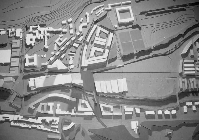
3 1.0 Introduction This document describes the Development Framework Plan for lands owned by CIE in the environs of Heuston Station. The Development Framework Plan is part of a wider study: Heuston Gateway Regeneration Strategy and Development Framework Plan. The proposal therefore is in line with the Development Framework Plan for the wider area, as described in Part 2: Regeneration Strategy and Development Framework Plan. 1 heuston gateway boundary CIE lands boundary sites Site Location The lands described in this document cover just under 18 hectares on 4 sites: Heuston Station (sites 2-4) and Conyngham Road Bus Depot (site 1). Please refer to Part 1 Scope and Context Report sections and for full description of lands. site area (sqm): Development Site area (sq.m): site site site total CIE lands location plan Gross floor area (sq.m): residential (10%) commercial (90%) total plot ratio: 2.5:1 site coverage: 24% Present zoning: Z6 / Z1 / Z9 Proposed zoning: Z6 / Z1 / Z9 / Z5 introduction

4 1.2 Site Description The Heuston area is a key focal point for the Dublin Region and Ireland as a whole, acting as a gateway and interface between the parks and city. The vision for the Heuston Gateway is to create a coherent and vibrant quarter of the city that captures the public imagination with high quality services, development, design and public spaces that consolidate and improve the existing strengths of the area. The Regeneration Strategy and Development Framework Plan are both dependent on the CIE lands for their realization. As the main transport hub and with its position in the centre of the area, the CIE lands are key to the regeneration and appropriate development of the area. CIE has extensive lands at the core of the study area: the Heuston Station Lands (sites 2-4) lie to the south of the river and the Conyngham Road Bus Depot (site 1) to the north. introduction
5 1.2.1 Heuston Station Lands (sites 2-4): The station building is of architectural distinction and importance and has recently been renovated. However the facilities for passengers and the efficiency of the station are poor. The station is isolated from the main city core by congested traffic routes and an hostile pedestrian and cycling environment. The layout of the platforms is restricted by the roof structure over the tracks and the critical width between the existing building and the bend in the river. The lands to the west of the station are inefficiently used with a large surface car park, access to the new platform 10, turning area for buses, storage and freight tracks for Guinness and other sidings. The valeting shed, new ESB sub station, new signalling building and new postal distribution building are located around the site. A number of other buildings housing records and staff facilities are positioned on the river or the wall to St John s Road. The capacity of the station has been recently increased with the addition of 3 new platforms, secondary concourse, installation of a digital signalling system and new bus stops. The site has an extensive river frontage from Sean Heuston Bridge to the railway bridge at the boundary with Clancy Barracks. The land is more or less flat and at a lower level than the north bank, Royal Hospital site and crossroads at South Circular Road. It is generally at a higher level than the Clancy Barracks site. The potentialities of the site are summarized to the right: To transform the entire area and redefine the image of the Heuston Gateway. Potential to define the gateway or interface between the Park and city, and therefore the limits of dense urban development in the city centre Extend city centre uses to the west. Proximity to Memorial Gardens, Clancy Barracks, Kilmainham Gaol and Royal Hospital, Eircom / OPW site at Military Road, Guinness lands, city centre, Collins Barracks and the Phoenix Park. Creation of a high quality efficient public transport facility Development of large areas of land not absolutely required by station uses, or development of over ground level secondary station uses. An increase in permeability across the site - the site currently blocks off adjacent areas. Extensive frontage and green environment along river. Creation of a mixed use development forming a high density focal hub at a major transport node. The area can accommodate a carefully located high building. Heuston Station Lands Heuston Station, Dublin introduction
6 1.2.2 CIE: Conyngham Road Bus Depot (site 1): This large site is currently accessed off Conyngham Road and is approximately 5 metres above the level of the Heuston Station Lands. The entrance is currently opposite the main city entrance gate to the Phoenix Park. The site is used by Dublin Bus as a depot for the central area. The site has elevated views to the south and extensive river frontage. Conyngham Road Bus Depot Potentialities of the site are summarized below: To provide a link from the northside across the river to the Heuston Station Lands The site has an elevated position with south facing views over to the Royal Hospital Kilmainham and north facing views into the Park across Conyngham Road. The site has close proximity to Heuston Station, Phoenix Park, the city centre and national institutions. There are excellent pedestrian and vehicular links to the city and parks. The development of the West Terrace extending from Conyngham Road across the river and tracks will allow controlled vehicular movement and access in to the northern station lands through the Bus Depot site. The external public space on the Bus Depot site should include provision for a function such as bus stops or holdings. Pedestrian access should be provided from this space down to the riverside walk on the north bank. The building to the east of the space should be 4 and 6 stories commercial or equivalent. The building on the west should be 5 stories residential. West of this site is within the significant view from the Royal Hospital Kilmainham to the Phoenix Park as described in section Conyngham Road Bus Depot introduction
7
 2. a proposed West Terrace.")
8 2.0 Development Framework Plan 2.1 It is proposed that the entire site of the Station and Bus Depot is developed to realise full potential. The development proposal is structured around 2 principal public and civic spaces: 1. the existing Heuston Square (to front of Headquarters building by the Liffey) 2. a proposed West Terrace. 1 The West Terrace is an elevated space to the west end of the station. The 2 spaces are linked by the station. The West Terrace forms part of a connection from the N4 on the south to the Conyngham Road on the north. A 2-way vehicular bridge and a separate pedestrian / cycle bridge should be constructed. High density commercial development is proposed onto the West Terrace, including one tall building. The remainder of the bus depot lands and station lands are proposed as residential and commercial development. CIE lands development plan location 2 overall development plan station forecourt / tall landmark building a. Canary Wharf Station, London [Sir Norman Foster & Associates] b. GSW Headquarters, Berlin [Sauerbruch Hutton] site 2: landmark buildings / commercial uses c. Nagaoka Auditorium, Niigata, Japan [Toyo Ito] d. Research Centre, Wageningen, Holland [Behnisch, Behnisch + Partner] housing relating to landscape: e. home and workplace building, Freiburg im Breisgau, Germany [Common + Gries] f. apartment building, Basel, Switzerland [Herzog and de Meuron] g. housing block, Dornbirn, Austria [Hermann Kaufmann] development using steep topography: h. Waverley Station, Edinburgh, Scotland a. b. c. d. e. f. g. h. l. development framework plan

9 CIE Lands Development Plan development framework plan
10 2.2 Conclusions The development of the CIE Lands is critical to the overall development of the Heuston Station Environs. The advantages to the CIE, the city and nation are summarised below: 1. The lands represent significant development potential for a mix of uses. 2. The current access is not adequate in light of future increased loading on station and introduction of LUAS 3. Without new infrastructure and a reorganisation of the adjoining spaces, the station will be unable to function efficiently and the lands development potential will not be realised. 4. New infrastructure on the lands is critical to the development of the wider area, and will greatly benefit adjoining stakeholders who will be required to contribute to the costs by levies. Neighbouring stakeholders will contribute significantly to costs via a system of levies. 5. The proposals will provide infrastructure and public space to allow the station to function efficiently development framework plan


11 3.0 Zoning The station is the central hub of the area and this function must be preserved and developed. However large areas of the Heuston Station lands are underused and should be integrated into the city fabric. The Conyngham Road Bus Depot should be relocated and the site developed along with the Heuston Station lands. The arc of the proposed pedestrian / cycle route effectively defines the gateway to the city and development adjacent to this line should have a high profile and high standard of architectural design. Sites to the west should generally be of lower density. The present zoning of the Heuston Station lands is Z6, to provide for the creation and protection of enterprise and facilitate opportunities for employment creation. The predominant proposed uses, offices and hotel, are permissible uses. Residential is open for consideration. An area of recreational amenity (Z9) is shown along the river. The bus depot site is presently zoned Z1. Office use is therefore not a permissable use although enterprise, light industry, retail and cultural uses are permitted. It is proposed that the zoning objectives are reviewed. Lands adjacent the arc of the proposed pedestrian and cycle route should be designated as Z5, to consolidate and facilitate the development of the central area, and to identify, reinforce, strengthen and protect its civic design character and dignity. This reflects the civic importance of these sites. Lands in the western section of the site and required for use by the station should remain Z6. Part of the lands to the west of the new road on Site 1 should become Z5, to provide for and improve mixed-services facilities. The areas of recreational amenity (Z9) should be retained and extended to include the public space of the West Terrace. Dublin Development Plan The station lands should be accessed by a new bridge over the river from the Conyngham Road site. The proposed pedestrian / cycle route links the Phoenix Park with the south city and Royal Hospital Kilmainham, defining the city centre elevation to the west. An additional pedestrian bridge from the Heuston Station Lands / Clancy Barracks, should be hung from the existing rail bridge. W E Dublin Development Plan, proposed rezoning zoning

12 4.0 Public Spaces and Associated Development The key public spaces for the Heuston Gateway are adjacent to the station, providing efficient transport connections and civic space. 1. West Terrace 2. Heuston Square 3. River Terrace 4. Heuston Station: South Facade 5. Conyngham Road Public Space public spaces public domain public spaces and associated development
development framework
 dublin city council: heuston gateway regeneration strategy substudy document: guinness udv lands Guinness UDV Lands development framework Dublin City Council Steering Group: Sean Carey Ast. City manager
HEUSTON GATEWAY PART 2: REGENERATION STRATEGY AND DEVELOPMENT FRAMEWORK PLAN
 HEUSTON GATEWAY PART 2: REGENERATION STRATEGY AND DEVELOPMENT FRAMEWORK PLAN Urban Projects for Dublin City Council Contents: 1.0 INTRODUCTION 1.1 background 1.2 the aim of this document 1.3 structure
heuston gateway: sections heuston gateway: regeneration strategy and development framework plan
 B B1 A B1 B C A heuston gateway: sections B B1 C 117 4.3.3 Zoning The station is the central hub of the area and this function must be preserved and developed. However large areas of the Heuston Station
heuston gateway: summary report
 Significant View: Royal Hospital Kilmainham to Phoenix Park. hoenix Park to Royal Hospital: view of Royal Hospital from Phoenix Park to Wellington Monument view of Royal Hospital rail bridge from Conyngham
4.00 STAKEHOLDERS. urbanprojects
 4.00 STAKEHOLDERS 94 heuston gateway: regeneration strategy and development framework plan 95 The Heuston Gateway presents one of the greatest concentrations of brown field development sites located adjacent
development framework plan
 3.2.1.1 Phoenix Park to Royal Hospital Kilmainham The Phoenix Park and Royal Hospital Kilmainham Park have been separated since the construction of the Heuston Station in the mid 1800s. Consequently both
3.1.1 Heuston Square. heuston gateway: regeneration strategy and development framework plan. Heuston Gateway: public domain: Heuston Square location
 3.1.1 Heuston Square The space to the front of the Headquarters Building of the Great Western Railway is considered to be in the centre of the Heuston Gateway. All destinations in the area radiate from
stakeholders Zoning Conservation Connections
 4.7.1 Zoning The Phoenix Park site is identified as an important gateway site to the city. The site should be developed as a landmark public building with office or cultural use. The present zoning, Z9,
public spaces and accociated development
 4.0 Public Spaces and Associated Development The development must address appropriately the public spaces immediately adjoining it: the River Walkway and Parkgate Street. The development is also highly
public spaces and associated development
 4.1 West Terrace (1) A new public space, the West Terrace, is proposed to the west of station, elevated over tracks. The West Terrace is part of a sequence of spaces running from IMMA to the Phoenix Park,
public spaces and associated development
 4.0 Public Spaces and Associated Development The Guinness lands are adjacent to 3 of the principal public spaces of the Development Framework Plan for the Heuston Gateway as described below. 4.1 Heuston
Page 1 of 19 URBAN DESIGN FRAMEWORK FOR BOLTON STREET WATERFORD
 Page 1 of 19 URBAN DESIGN FRAMEWORK FOR BOLTON STREET WATERFORD 1.0 Introduction: The relocation of the City Council stores and depot from Bolton Street creates an exciting opportunity for development
Colchester Northern Gateway Master Plan Vision Review Draft. July 2016
 Colchester Northern Gateway Master Plan Vision Review Draft July 2016 Contents Introduction 4 Context 8 Purpose of the Report 8 Strategic Position 9 Overview of the Process 11 2012 Master Plan Vision 12
GREENFORD HALL & ADJOINING LAND
 GREENFORD HALL & ADJOINING LAND CONTENTS 1. Introduction 1. Introduction 2. Urban Context 2.1 The Site and Surroundings 2.2 Urban Context Map 2.3 Access and Movement 3. Planning Context 3.1 Planning History
heuston gateway: scope and context
 suburban rail DART (proposed by DTO) LUAS (under construction) 1000 metre radius QBC Heuston Gateway: public transport heuston gateway: scope and context 33 Heuston Gateway: private transport survey urbanprojects
Site 2 Development Brief
 a South Marketgait Site 2 b Union Street c Site 2 Development Brief Thomson Avenue (Northern Boulevard) Dundee Riverside Drive Discovery Plaza South Union Street Station Earl Grey Place West Site 5 Site
6.0 Development of Amenities,
 6.0 Development of Amenities, conservation of architectural heritage and other features This chapter outlines the Area's significant potential to provide for amenities of city wide and local importance
Chapter 5 Urban Design and Public Realm
 5.1 Introduction Public realm is all areas of the urban fabric to which the public have access. It is where physical interaction takes place between people. It therefore, includes buildings and their design,
20. Ballysadare Mini-Plan
 20. Ballysadare Mini-Plan 20. Ballysadare Mini-Plan Community facilities Ballysadare has a wide range of community facilities: a primary school, St Mary s College (secondary school), a health centre, playing
Memorial Business Park Site. Proposed Future Development. Design guidelines. August
 Memorial Business Park Site Proposed Future Development Design guidelines August 2014 www.designenvironment.co.nz 0064 3 358 3040 Contents 1.0 Background 1.1 Introduction 3 1.2 Objectives 4 2.0 Context
DUBLIN DOCKLANDS MASTER PLAN AND RELATIONSHIP WITH OTHER PLANS
 .1 National Policy and Programmes.1.1 Sustainable Development A Strategy for Ireland, 1997.1.2 National Climate Change Strategy, 2007-2012.1. National Development Plan 2007-201.1.4 National Spatial Strategy,
survey 2.4 OWNERSHIP AND USE introduction:
 2.4 OWNERSHIP AND USE 2.4.1 introduction: The land use map for the study area is characterised by the industrial area of Guinness, the open space around the Royal Hospital, the transport area of the station,
Keystone Business Park Precinct Structure Plan North East Industrial Precinct. Part 2 Design Principles
 Keystone Business Park Precinct Structure Plan North East Industrial Precinct Part 2 Design Principles Context Issues Services Landform Issues Geotech and contamination Ecology Traffic and access Issues
Chapter 2: OUTLINE PLANNING APPLICATION PROPOSALS. A New Garden Neighbourhood Matford Barton 17
 Chapter 2: OUTLINE PLANNING APPLICATION PROPOSALS A New Garden Neighbourhood Matford Barton 17 2.1. SUMMARY AND STATUS OF THE PROPOSALS 2.1.1. The parameter plans and associated wording in this chapter
8.0 Design and Form of Development 43/
 42/ 8.0 Design and Form of Development 43/ Rothwells Farm, Golborne/ Development Statement Figure 7. Site Constraints Key 44/ Site Boundary 360 Bus Route/Stops Existing Trees Underground Water Pipe Sensitive
2.0 Strategic Context 4
 2.0 Strategic Context 4 2.1 The Area Action Plan is a non-statutory plan, which forms a corporate policy document, expressing particular issues and areas of concern while also providing a vision for the
Housing Land Initiative. Feasibility Study. Update
 Report to the Housing & Community Strategic Policy Committee Housing Land Initiative Feasibility Study Update September 2016 Oscar Traynor Road Site Site Description Dublin City Council owns a 17.014 ha
3.1 The hybrid planning application proposes the following description of development:
 CHAPTER 3: PROPOSED DEVELOPMENT 3.1 The hybrid planning application proposes the following description of development: Hybrid (part-outline/part-full) planning application for a single composite development
SUB AREA 3 CENTRAL STRATFORD AND SOUTHERN QUEEN ELIZABETH OLYMPIC PARK
 191 ADOPTED LOCAL PLAN: THE SUB AREAS SUB AREA 3 CENTRAL STRATFORD AND SOUTHERN QUEEN ELIZABETH OLYMPIC PARK SECTION 12 Vision VISION Central Stratford and Southern Queen Elizabeth Olympic Park will become
3.3. Urban Structure Defining a New Hierarchy of Routes and Spaces >Images
 Section 3.0 I The Masterplan Framework 18 >Images Examples of high quality routes and spaces 3.3. Urban Structure The success of any masterplan lies in a clear definition of the future urban structure
County Development Plan Consolidated Draft + Adopted Amendments August 2017 Volume 2, Chapter 22 Easky Mini-Plan
 22. Easky Mini-Plan Village profile Easky is a coastal settlement located approximately 40 km to the west of Sligo City, in a designated Rural Area In Need of Regeneration. The nearby coastline is designated
17. Coolaney-Rockfield Mini-Plan
 County Development Plan 2017-2023 Consolidated Draft + Adopted Amendments - August 2017 17. Coolaney-Rockfield Mini-Plan Village profile Coolaney is located approximately 23 km to the south-west of Sligo
Kidbrooke Village Forthcoming Planning Proposals Phases 3, 5 and 6
 July 2014 Kidbrooke Village Forthcoming Planning Proposals Phases 3, 5 and 6 Design Evolution and changes since our last consultation This document outlines how the feedback received from our last consultation
Environmental Impact Statement
 Environmental Impact Statement of Development Proposals contained in the Planning Scheme for Docklands North Lotts August 2001 IRE 5.00 CONTENTS Non Technical Summary 1.0 INTRODUCTION 1 1.1 Background
3.0 Area-Wide Strategies 30
 3.0 Area-Wide Strategies 30 3.6 Tourism Strategy This section of the plan aims to develop and improve the tourism potential of the area. Strategic Context The City Plan outlines the potential of Cork to
Woodbrook - Shanganagh
 Section 4: Key Sites Framework Strategy Woodbrook - Shanganagh Local Area Plan 2017-2023 4. Site Framework Strategies The Master Plans shall have regard to the thematic objectives under the LAP Development
28. Coolaney-Rockfield Mini-Plan
 28. Coolaney-Rockfield Mini-Plan 28. Coolaney-Rockfield Mini-Plan Community facilities Community facilities in Coolaney-Rockfield consist of a primary school, crèche, community centre, sports field and
ALTERNATIVE PROPOSAL FOR TRI LOCATED NATIONAL PAEDIATRIC HOSPITAL BY 2016 ON A 20.5 ACRE (8.3 HECTARE) SITE
 SITE") ALTERNATIVE PROPOSAL FOR TRI LOCATED NATIONAL PAEDIATRIC HOSPITAL BY 2016 ON A 20.5 ACRE (8.3 HECTARE) SITE EXECUTIVE SUMMARY This is a viable and achievable proposal to realise an iconic tri located National
ALTERNATIVE PROPOSAL FOR TRI LOCATED NATIONAL PAEDIATRIC HOSPITAL BY 2016 ON A 20.5 ACRE (8.3 HECTARE) SITE EXECUTIVE SUMMARY This is a viable and achievable proposal to realise an iconic tri located National
1.0 Purpose of a Secondary Plan for the Masonville Transit Village
 Report to Planning and Environment Committee To: Chair and Members Planning & Environment Committee From: John M. Fleming Managing Director, Planning and City Planner Subject: Masonville Transit Village
HS2 Interchange Station Design
 Working on behalf of HS2 Interchange Station Design October 2018 www.hs2.org.uk 1 Interchange Station, Solihull Introduction In February 2018, HS2 Ltd appointed Arup to take forward the design of Interchange
YONGE STEELES CORRIDOR SECONDARY PLAN. Young + Wright / IBI Group Architects Dillon Consulting Ltd. GHK International (Canada) Ltd.
 Ltd.") PART A: PREAMBLE 1.0 PURPOSE The purpose of this Secondary Plan is to provide a development framework for intensification of the Yonge/ Steeles corridor including the north side of Steeles Avenue West
PART A: PREAMBLE 1.0 PURPOSE The purpose of this Secondary Plan is to provide a development framework for intensification of the Yonge/ Steeles corridor including the north side of Steeles Avenue West
Derry Green Corporate Business Park
 Town of Milton Derry Green Corporate Business Park Urban Design Guidelines BMI/Pace - June 2010 Draft 3 Prepared by: Brook McIlroy Planning + Urban Design / Pace Architects Suite 300-51 Camden Street Toronto,
30. Riverstown Mini-Plan
 County Development Plan 2017-2023 Consolidated Draft + Adopted Amendments August 2017 Volume 2, Chapter 30 Riverstown Mini-Plan 30. Riverstown Mini-Plan Village profile Riverstown is located approximately
6 Site Framework Strategies
 6 Site Framework Strategies 6.1 Introduction Section 6 identifies a number of specific areas which are considered to be key sites within the Plan area and which may have potential for development / redevelopment.
Site 5 Development Brief
 Union Street Crichton Street South Crichton Street Thomson Avenue (Northern Boulevard) Site 5 South Union Street Earl Grey Place West Site 6 Riverside Esplanade (Southern Boulevard) South Crichton Street
35. Gorteen Mini-Plan
 35. Gorteen Mini-Plan 35. Gorteen Mini-Plan Community facilities Community facilities in Gorteen consist of a crèche, community centre, sports field, church, burial ground and health centre. The former
[PLANNING RATIONALE] For Site Plan Control and Lifting of Holding Zone By-Law 101 Champagne Avenue. May 23, 2014
![[PLANNING RATIONALE] For Site Plan Control and Lifting of Holding Zone By-Law 101 Champagne Avenue. May 23, 2014](/thumbs/75/71599615.jpg "[PLANNING RATIONALE] For Site Plan Control and Lifting of Holding Zone By-Law 101 Champagne Avenue. May 23, 2014") [PLANNING RATIONALE] For Site Plan Control and Lifting of Holding Zone By-Law 101 Champagne Avenue May 23, 2014 Contents 1.0 Introduction... 2 2.0 Site Context... 2 2.1 Adjacent Uses... 2 Figure 1: Site
[PLANNING RATIONALE] For Site Plan Control and Lifting of Holding Zone By-Law 101 Champagne Avenue May 23, 2014 Contents 1.0 Introduction... 2 2.0 Site Context... 2 2.1 Adjacent Uses... 2 Figure 1: Site
Horwood Map of London, Westminster & Southwark First edition
 Barratt London is developing plans in tandem with Southwark Council and TfL to transform the southern end of Blackfriars Road. The residential-led, mixed-use scheme will deliver new private and affordable
A. The sites in Table 16 below, as identified on the Policies Map, are allocated for retail-led development:
 SWDP 44: Worcester City Centre A. The sites in Table 16 below, as identified on the Policies Map, are allocated for retail-led development: Table 16: Sites Allocated for Retail-Led Development Policy Reference
The Proposed Auckland Unitary Plan (notified 30 September 2013)
") 3 Business zones Introduction There are 10 business zones in the Unitary Plan: City Centre Metropolitan Centre Town Centre Local Centre Neighbourhood Centre Mixed Use General Business Business Park Light
3 Business zones Introduction There are 10 business zones in the Unitary Plan: City Centre Metropolitan Centre Town Centre Local Centre Neighbourhood Centre Mixed Use General Business Business Park Light
AGINCOURT SECONDARY PLAN
 1 AGINCOURT SECONDARY PLAN 1. AGINCOURT SECONDARY PLAN The following policies and principles apply to the area herein referred to as Agincourt, as outlined on Map 1-1. 1. GENERAL POLICIES 1.1 This Secondary
3.5 Principle 5/Response
 5 Principle 5/Response Existing street network Proposed street network Pedestrian street hierarchy Existing streets Existing Regional Arterial 4 Existing Street Network Existing and proposed streets Indicative
FRUITVALE TRANSIT VILLAGE (Phase 2) Residential Project
 Residential Project") FRUITVALE TRANSIT VILLAGE (Phase 2) Residential Project DEVELOPER: SIGNATURE PROPERTIES ARCHITECT: HKIT ARCHITECTS April 23, 2010 TABLE OF CONTENTS 3 Vision 4 Description of Site 5 Guiding Concepts 6
FRUITVALE TRANSIT VILLAGE (Phase 2) Residential Project DEVELOPER: SIGNATURE PROPERTIES ARCHITECT: HKIT ARCHITECTS April 23, 2010 TABLE OF CONTENTS 3 Vision 4 Description of Site 5 Guiding Concepts 6
MOUNT AVENUE MASTERPLAN WORKING DRAFT NOVEMBER 2006
 MOUNT AVENUE MASTERPLAN WORKING DRAFT NOVEMBER 2006 1 1. OVERALL MASTERPLAN IDENTITY: Dun Dealgan motte and bailey The Dun Dealgan motte and bailey, a national monument, is located to the north east of
Complete Neighbourhood Guidelines Review Tool
 Complete Neighbourhood Guidelines Review Tool Prepared By: City of Regina Planning Department October 2014 Page 1 of 14 Community Development Review Checklist for Secondary Plans and Concept Plans The
Bank Street Secondary Plan
 1.1 Introduction The is a guide to the long term design and development of the portion of Bank Street between Riverside Drive and Ledbury Park, and provides direction on land use, built form, design, parking,
4.5 Key Development Sites Site Development Frameworks
 4.4.4 Plot Ratio Plot ratio is a tool to help control the bulk and mass of buildings. It expresses the amount of floorspace in relation (proportionally) to the site area, and is determined by the gross
01 the vision NEW LYNN IS WAITING FOR THE GREAT LEAP FORWARD
 [A] FRAMEWORK 01 the vision 02 the framework 03 urban design principles 04 c o n t e x t 05 issues a n d o p p o r t u n i t i e s 06 creating a t.o.d. 07 key recommendations 08 seven strategic areas of
Legal & General Launches Walbrook Square
 Press release 19 May 2006 Legal & General Launches Walbrook Square Legal &General has today submitted plans for a striking new office and retail development, to be known as Walbrook Square. The development
burlington mobility hubs study Downtown Burlington Mobility Hub
 burlington mobility hubs study Downtown Burlington Mobility Hub Draft Precinct Plan Workbook PIC #3, September 7, 2017 downtown mobility hub objectives City staff and their consultants are proposing an
Clairtrell Area Context Plan
 Clairtrell Area Context Plan March 2005 Urban Development Services City Planning Contents 1. Introduction... 4 2. Development Structure... 6 2.1 Streets... 7 2.1.1 Sheppard Avenue and Bayview Avenue...
Proctor Tweedbank Spatial & Matthews Framework Architects
 Proctor Tweedbank Spatial & Matthews Framework Architects 30.11.2017 Tweedbank Spatial Framework report compiled by: 2017 Proctor and Matthews Architects 7 Blue Lion Place 237 Long Lane London SE1 4PU
PUBLIC REALM STUDY AREA
 WELCOME PUBLIC REALM STUDY AREA WHAT IS PUBLIC REALM? Welcome to the Ballina Town Public Realm public consultation event. Mayo Council is in the process of producing a Public Realm Strategy for Ballina
APPENDIX 1: SITE ALLOCATIONS. GREAT WEST CORRIDOR Local Plan Review
 APPENDIX 1: SITE ALLOCATIONS GREAT WEST CORRIDOR Local Plan Review 1000 Great West Road Ward: Brentford Address: 1000 Great West Road Brentford TW8 9DW Source: Call for sites 2016 PTAL: 2 Site Area (ha):
Session 4 New Urban Regions and Major Urban Extensions. Tackling Western Sydney s Urban Growth
 Session 4 New Urban Regions and Major Urban Extensions Tackling Western Sydney s Urban Growth Stephanie Barker Rohan Dickson & Associates and consultant to NSW Growth Centres Commission Friday 8 February
REMARKABLES PARK ZONE
 .10 Remarkables Park Zone.10.1 Resources, Activities and Values The Remarkables Park Area comprises approximately 150 hectares of perimeter urban land in the vicinity of Frankton and occupies a strategic
WINCHESTER TOWN 3.1 LOCATION, CHARACTERISTICS & SETTING
 WINCHESTER TOWN 3.1 LOCATION, CHARACTERISTICS & SETTING 3.1.1 The area referred to by the City Council, as Winchester Town, consists of the Winchester Wards plus the adjoining built up areas of Badger
13. London Bridge London Bridge Area Vision
 13. 13.1. Area Vision 13.1.1. is: A globally significant central London business district which is home to international business headquarters; Internationally renowned for its prominent riverfront location
New Homes at Winton East
 View toward Winton East from Caerketton Hill Aerial photograph of South Edinburgh: Winton East Site Location Indicative proposal Welcome Thank you for coming to the Winton East public exhibition. We would
London Bridge London Bridge Area Vision Map
 Area Vision Map Borough Market Southwark Cathedral NSP54 Hay s Galleria Key: NSP Site Allocations Greenspace Low Line Thames Path Cycle Network Primary Shopping Areas Borough High Street Tube Station NSP51
URBAN DESIGN BRIEF NORTHVIEW FUNERAL HOME HIGHBURY AVE N, LONDON, ON
 URBAN DESIGN BRIEF NORTHVIEW FUNERAL HOME - 1490 HIGHBURY AVE N, LONDON, ON 1.1Purpose The intent of the following report is to identify an opportunity for redevelopment of two residential properties within
0 9 Areas of Change 59
 09 Areas of Change 59 09 Areas of Change This section explores seven areas of change within Solihull Town Centre which provide practical interventions in order to deliver the emerging concepts outlined
TOWN CENTRE (TC 1-4) URBAN FORM DEVELOPMENT FRAMEWORK Cherrywood Planning Scheme
 URBAN FORM DEVELOPMENT FRAMEWORK Cherrywood Planning Scheme") TOWN CENTRE (TC 1-4) URBAN FORM DEVELOPMENT FRAMEWORK Cherrywood Planning Scheme September 2017 B Cherrywood Town Centre Urban Form Development Framework September 2017 Contents 1 INTRODUCTION 3 1.1 Background
TOWN CENTRE (TC 1-4) URBAN FORM DEVELOPMENT FRAMEWORK Cherrywood Planning Scheme September 2017 B Cherrywood Town Centre Urban Form Development Framework September 2017 Contents 1 INTRODUCTION 3 1.1 Background
UNIVERSITY TOWN NEIGHBOURHOODS 5.5 HOUSING MELBOURNE CAMPUS MASTER PLAN 2014
 5.5 169 EXISTING CONDITIONS & VISION NEIGHBOURHOOD VISION The provision of on-campus housing into the future will continue to be an important element of the La Trobe University experience. A long-term
EXISTING COMPREHENSIVE PLAN
 EXISTING COMPREHENSIVE PLAN Town Center Land Use Element: V. LAND USE POLICIES Town Center Mercer Island's business district vision as described in "Your Mercer Island Citizen-Designed Downtown" was an
Anatomy of A Vibrant Downtown. Anatomy of a Vibrant Downtown
 Anatomy of A Vibrant Downtown The goal of MAIN ST. REVITALIZATION PLANNING is to provide a framework that will help transform your downtown into a VIBRANT DOWNTOWN a place where people love to LIVE, WORK,
Appendix 7 Precinct Analysis Carlton
 Appendix 7 Precinct Analysis Carlton (Andover Street) Rezone from R2 Low Density Residential to R3 Medium Density Residential Retain existing B1 Neighbourhood Centre zone Existing Zoning Map (R2 Low Density
REPORT BACK BROADSHEET 3 May 2016
 Paddington Place REPORT BACK BROADSHEET May 06 Architects and planners should work with the community first and then thinking about developers profits second. - Quote from participant at Paddington Place
BESSARION-LESLIE CONTEXT PLAN
 Development in the Bessarion-Leslie area will be consistent with the following urban design guidelines. They provide a framework for development in the area and are to be read in conjunction with the urban
ACKNOWLEDGEMENTS PROJECT TEAM
 ACKNOWLEDGEMENTS La Trobe University proudly acknowledges the Dja Dja Wurrung people, the traditional custodians of the land upon which the Bendigo Flora Hill campus is located. We recognise that Indigenous
Workshop 3. City of Burlington Waterfront Hotel Planning Study. September 14, The Planning Partnership
 Workshop 3 City of Burlington Waterfront Hotel Planning Study September 14, 2017 The Planning Partnership The Waterfront Hotel Planning Study 01 The Brant & Lakeshore Planning Study will establish a Strategic
Eastbourne Borough Council. Summary Proof of Evidence Of Barry John Cansfield BA (Hons), BTP, MRTPI on behalf of PRLP
, BTP, MRTPI on behalf of PRLP") Eastbourne Borough Council (Arndale Centre and surrounding Land at Terminus Road, Sutton Road and Ashford Road) (Compulsory Purchase Order 2015) Section 226 (1)(a) of the Town and Country Planning Act
Eastbourne Borough Council (Arndale Centre and surrounding Land at Terminus Road, Sutton Road and Ashford Road) (Compulsory Purchase Order 2015) Section 226 (1)(a) of the Town and Country Planning Act
Vision for East Cowes
 Vision for East Cowes A better East Cowes for now and the future The East Cowes Regeneration project is a major regeneration scheme on the Isle of Wight. It will create a vibrant community with a long-term
PUTTING THE HEART INTO BATTERSEA. A vision
 PUTTING THE HEART INTO BATTERSEA A vision INTRODUCTION This document is a vision for creating a Battersea that its community can be proud of and it is about putting Battersea on the map. It is being proposed
URBAN DESIGN BRIEF URBAN DESIGN BRIEF 721 FRANKLIN BLVD, CAMBRIDGE August 2018
 URBAN DESIGN BRIEF URBAN DESIGN BRIEF 721 FRANKLIN BLVD, CAMBRIDGE August 2018 DESIGN BRIEF CONTENTS PART A 1.0 INTRODUCTION 2.0 DESCRIPTION & ANALYSIS OF SITE CONTEXT 3.0 DESIGN CONSTRAINTS AND OPPORTUNITIES
97 Lea Bridge Road, Leyton, E10 7QL London Borough of Waltham Forest December 2015
 97 Lea Bridge Road, Leyton, E10 7QL London Borough of Waltham Forest December 2015 Public Realm and Landscape Proposals LEA BRIDGE ROAD, WALTHAMSTOW Public Realm & Landscape Proposals BDP(90)RPT001 December
13 THORNHILL YONGE STREET STUDY IMPLEMENTATION CITY OF VAUGHAN OPA 669 AND TOWN OF MARKHAM OPA 154
 13 THORNHILL YONGE STREET STUDY IMPLEMENTATION CITY OF VAUGHAN OPA 669 AND TOWN OF MARKHAM OPA 154 The Planning and Economic Development Committee recommends the adoption of the recommendations contained
Study of the Economic Value of Northern
 Study of the Economic Value of Northern Ireland s Historic Environment Summary Report on behalf of: Department of the Environment June 2012 eftec and RSM McClure Watters i May 2012 1 Introduction to the
and Richmond Street West - Official Plan Amendment Application - Preliminary Report
 STAFF REPORT ACTION REQUIRED 822-838 and 860-862 Richmond Street West - Official Plan Amendment Application - Preliminary Report Date: August 14, 2017 To: From: Wards: Reference Number: Toronto and East
Land at Fiddington Hill Nursery, Market Lavington
 Land at Fiddington Hill Nursery, Market Lavington Briefing Report for Market Lavington Parish Council Persimmon Homes (Wessex) April 2016 Background This brief report has been prepared following the Market
Land Use Amendment in Southwood (Ward 11) at and Elbow Drive SW, LOC
 at and Elbow Drive SW, LOC") 2018 November 15 Page 1 of 10 EXECUTIVE SUMMARY This land use amendment application was submitted by Rick Balbi Architect on 2017 August 31 on behalf of Sable Developments Ltd, and with authorization from
2018 November 15 Page 1 of 10 EXECUTIVE SUMMARY This land use amendment application was submitted by Rick Balbi Architect on 2017 August 31 on behalf of Sable Developments Ltd, and with authorization from
Phase I Redevelopment Plan. First Community Meeting
 Hoboken Terminal and Yard Phase I Redevelopment Plan First Community Meeting May 31, 2011 One Hudson Place Phase I Redevelopment Plan Redevelopment Plan First Community Meeting Agenda 1. Redevelopment
Hockessin Community Redevelopment Plan
 Hockessin Community Redevelopment Plan 3.1 Introduction The Community Redevelopment Plan for the Village of Hockessin is the result of the people s vision for a distinct village center that serves as the
1.3 TRANSIT VISION 2040 FROM VISION TO ACTION THEME 1: PUTTING TRANSIT AT THE CENTRE OF COMMUNITIES. Fully integrate transit with community planning
 TRANSIT VISION 2040 FROM VISION TO ACTION TRANSIT VISION 2040 defines a future in which public transit maximizes its contribution to quality of life with benefits that support a vibrant and equitable society,
MODERN GRADE A OFFICE SPACE TO LET
 MODERN GRADE A OFFICE SPACE TO LET A signature office building in a pivotal location 2HSQ IS A MODERN OFFICE building offering 56,460 sq.ft of flexible, efficient floorplates and high quality specifications.
Newcourt Masterplan. November Exeter Local Development Framework
 Newcourt Masterplan November 2010 Exeter Local Development Framework Background The Exeter Core Strategy Proposed Submission sets out the vision, objectives and strategy for the development of Exeter up
IF I CAN GET TO THE HEART OF DUBLIN I CAN GET TO THE HEART OF ALL THE CITIES OF THE WORLD. James Joyce
 IF I CAN GET TO THE HEART OF DUBLIN I CAN GET TO THE HEART OF ALL THE CITIES OF THE WORLD. James Joyce INTRODUCTION... 07 VISION... 09 THE STORY OF ST. JAMES S GATE... 11 THE FUTURE OF ST. JAMES S GATE...
URBAN DESIGN BRIEF. 2136&2148 Trafalgar Road. Town of Oakville
 URBAN DESIGN BRIEF 2136&2148 Trafalgar Road Town of Oakville Prepared By: METROPOLITAN CONSULTING INC For 2500674 Ontario Inc November 2016 TABLE OF CONTENTS Page No. 1.0 Introduction/Description of Subject
City of Farmington. Downtown Plan. Amendment to the 1998 Master Plan Adopted October 11, 2004
 City of Farmington Amendment to the 1998 Master Plan Adopted October 11, 2004 Introduction Planning Background 1 Scope and Components of the Plan Amendment 2 Concept Introduction 3 Plan Concepts 3 Conceptual
I615. Westgate Precinct
 I615. Westgate Precinct I615.1. Precinct Description The Westgate Precinct is located approximately 18km west of the Auckland city centre. There are seven Sub-precincts in the Westgate Precinct: Sub-precinct