Table of Contents SASD SEWER SYSTEM CAPACITY PLAN 2010 UPDATE EXECUTIVE SUMMARY
|
|
|
- Jasmine Cox
- 5 years ago
- Views:
Transcription

1
2
3 SASD SEWER SYSTEM CAPACITY PLAN 2010 UPDATE EXECUTIVE SUMMARY Table of Contents 1. Objectives and Scope Land Use Update...1 Study Area...1 Planning Updates...2 Land Use Map and Projections Assumptions and Criteria...4 Flow Parameters...4 Performance Criteria Hydraulic Modeling Relief Area Evaluation...6 System Capacity Evaluation & Results...6 Planning Period 1 Results...7 Planning Period 2 Results...7 Planning Period 3 Results...7 Relief Solution Development Expansion Area Evaluation...8 Delineation of Expansion Trunk Sheds...8 Development of Expansion Trunk Projects...8 Year 2020 Expansion Plan...9 Buildout Expansion Plan...9 Expansion Trunk Shed Plans SCP Capital Funding Projections Relief Area Capital Funding Projections Expansion Area Capital Funding Projections i
4 SASD SEWER SYSTEM CAPACITY PLAN 2010 UPDATE EXECUTIVE SUMMARY List of Figures Figure SCP Study Area Figure SCP s Anticipated Development Areas Figure SCP Consolidated Land use Map (Design ESD Density Map) Figure 2-4. New Developments by Year Figure 2-5. Percent Buildout by Year Figure 2-6. Redevelopment Areas under Buildout Conditions Figure Model Results (Relief Area Evaluation) Figure Model Results (Relief Area Evaluation) Figure 5-3. Buildout Model Results (Relief Area Evaluation) Figure 6-1. SASD Trunk Sheds in 2010 SCP Study Area Figure 6-2. Future Expansion Facilities by Year Figure 6-3. Future Expansion Facilities by Buildout Figure 6-4. Original Sheldon Interceptor Design vs. New Design in 2010 SCP Figure 6-5. Example of Year 2020 Expansion Plan Map Figure 6-6. Example of Year Buildout Expansion Plan Map Figure 6-7. Example of Sewer Shed Map Figure 7-1. Cost Estimate Sheet Example List of Tables Table SCP Planning Scenarios and Projected ESDs...2 Table SCP Land Use Categories and Design ESD Densities...3 Table SCP Flow Parameters...4 Table SCP s Performance Criteria (using SASD s 10-year Design Storm Condition)....5 Table 5-1. Summary of potential capacity deficient systems for each planning period....7 Table 6-1. Expansion Trunk Sheds Identified by the 2010 SCP Table 7-1. Funding Periods for SASD s Relief area (with respect to planning periods) Table 7-2. Funding Periods for SASD s Expansion area (with respect to development timing) Table SCP s Trunk System Capital Funding Projections Table 7-4. SASD Relief Area: Potentially Capacity Deficient Sewer Systems ii
5 SASD SEWER SYSTEM CAPACITY PLAN 2010 UPDATE EXECUTIVE SUMMARY 1. OBJECTIVES AND SCOPE The primary objective of the Sacramento Area Sewer District (SASD) 2010 Sewer System Capacity Plan (SCP) update was to develop a high-level planning and dynamic sewer capacity plan that addresses existing, midrange, and buildout sewer capacity needs. Existing capacity needs are based on SASD s current sewer system conditions. The mid-range capacity needs are based on plans to provide sewer service to SASD s service area within the next 10 years. The buildout capacity needs are based on providing sewer service to the entire SASD service area. One of the goals of the 2010 SCP was to provide updated capital costs and capacity-based funding projection information for SASD s service areas. According to SASD s Sewer Ordinance, the service area is divided into two geographical areas: the relief area and the expansion area. RELIEF AREA: The focus of the 2010 SCP was to identify potential capacity deficiencies and develop preliminary solutions to restore system performance. The preliminary solutions were mainly developed so that capital costs may be estimated for funding projections. EXPANSION AREA: The focus of the 2010 SCP was to update expansion alternatives from previous SASD planning documents (e.g., 2006 SCP and recently completed mid-range planning reports). The 2010 SCP provides updated conceptual plans for providing sewer service to undeveloped areas. DISCLAIMER For the expansion area, the future sewer flows were estimated based on: Flows from the initial phase of the development (as mentioned in sewer studies and other planning documents available). Assumptions of future growth within the next 10 years and through buildout. The flow capacities considered for each area of development are not guaranteed and were used only for planning purposes. SASD does not reserve capacity for any development until sewer impact fees are paid. Since the 2010 SCP is a high level planning document, the expansion trunk projects developed in this study may not be the final projects. Expansion project alternatives may be further evaluated and developed through SASD s mid-range planning efforts if necessary. 2. LAND USE UPDATE SASD does not have jurisdiction to make land use planning decisions within its service area. Instead, SASD relies on the land use plans created by jurisdictions within its boundaries. SASD used the jurisdictions latest land use plans and growth projections to estimate the sewer system s future capacities and to evaluate locations where population growth may require new collector and trunk facilities. Study Area Before developing future land use projections, the project team defined the boundaries of SASD s future service area, which represents the study area for the 2010 SCP. SASD s approved Sphere of Influence (SOI) is the service area officially designated for SASD s future planning. SASD s SOI corresponds to Sacramento County s Urban Services Boundary (USB) with the exception of the areas served by the Cities of Sacramento and Folsom and by the Rancho Murieta Community Services District. Page 1
6
7

8
9
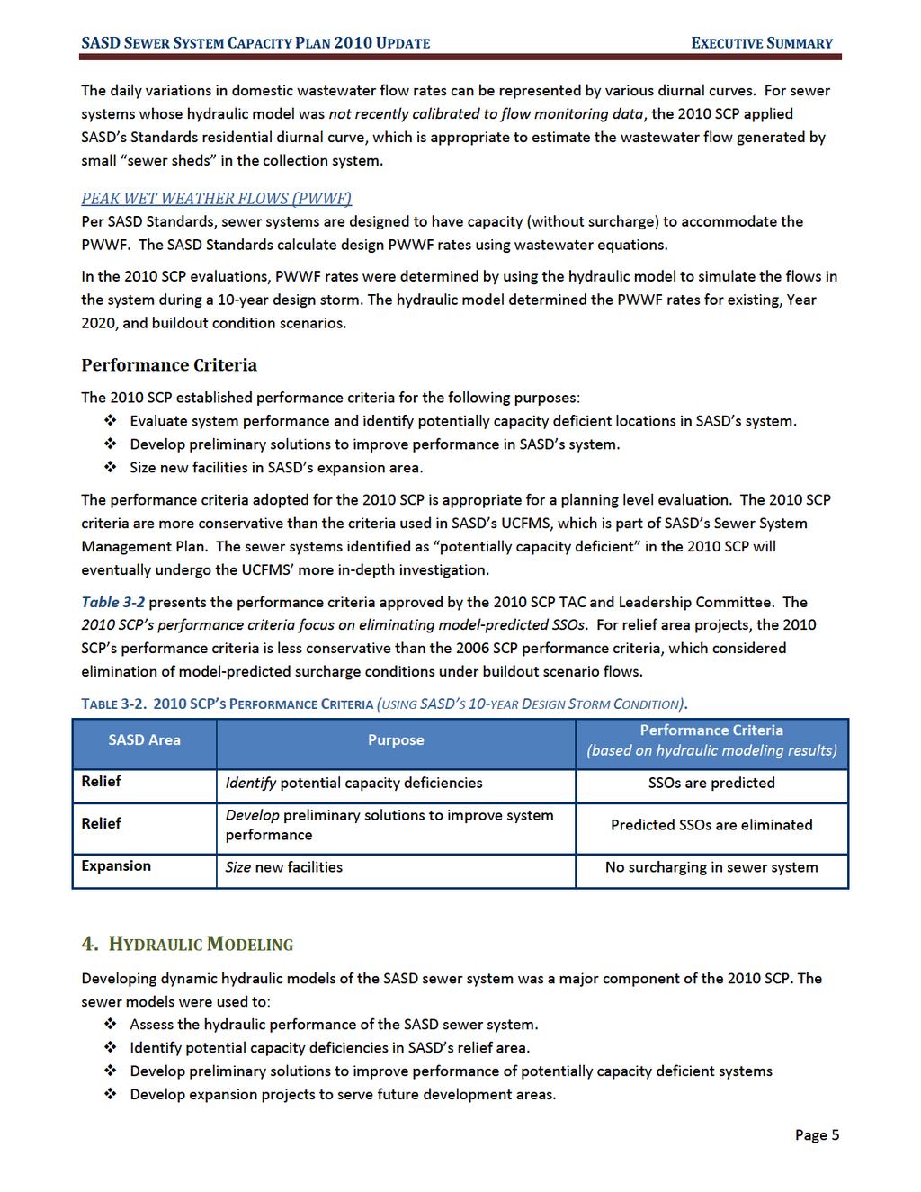
10 SASD SEWER SYSTEM CAPACITY PLAN 2010 UPDATE EXECUTIVE SUMMARY To achieve the goals of the 2010 SCP, the following sets of SASD hydraulic models were created: 2010 Model 2020 Model Buildout Model Solution/Buildout Models. The 2010 model simulated flows in the existing system. This model was constructed based on existing land use conditions and was used to assess the current hydraulic performance of the SASD sewer system. The 2020 model was built from the 2010 model and included the following: New developments anticipated by Year Expansion facilities needed to serve these new developments. Projects anticipated to be completed by the McClellan Business Park in the next few years including ARD- 6, ARD-7, and lift station 706. The buildout model reflects the service area s projected buildout land use conditions and includes both existing facilities and future expansion facilities. The buildout model was constructed based on two assumptions: Assumption 1: All of the flows from the Cripple Creek trunk, the C-line trunk, and the Upper Northwest Interceptor Section 9 will be diverted to the Van Maren Pump Station to relieve the Mission Trunk. Assumption 2: The Dry Creek Interceptor Relief will be constructed by buildout. Preliminary relief solutions were developed to improve system performance in potentially capacity deficient systems under the existing, near term, and buildout conditions. The preliminary relief solutions were then incorporated into the buildout model to create the final set of the SCP model - the solution/buildout model. The solution/buildout model simulated buildout flows in the ultimate SASD facilities. This model was also used to study the impacts of surcharged flows from the SRCSD interceptor system on the SASD system under buildout conditions. 5. RELIEF AREA EVALUATION In SASD s relief area, the goals of the 2010 SCP were to: Assess the hydraulic performance of the SASD system Identify potential capacity deficiencies Develop preliminary solutions for this SCP s capital funding projections (CFP). Unlike the previous SCPs, the 2010 SCP does not include detailed information on potential relief projects. Instead, the 2010 SCP primarily identifies potentially capacity deficient systems in the SASD relief area. The 2010 SCP also developed preliminary solutions to meet system performance criteria so that planning-level costs can be estimated for SASD s updated CFP. The systems flagged to be potentially capacity deficient will be further investigated through SASD s UCFMS. System Capacity Evaluation & Results Potentially capacity deficient systems were divided into three different planning periods: Planning Period 1: Model predicted overflows under existing conditions. Planning Period 2: Model predicted overflows under 2020 conditions (excluding Planning Period 1 systems). Planning Period 3: Model predicted overflows under buildout conditions (excluding Planning Periods 1 and 2 systems). Page 6

11
12 SASD SEWER SYSTEM CAPACITY PLAN 2010 UPDATE EXECUTIVE SUMMARY Relief Solution Development So that cost information is available for funding projections, SASD developed preliminary solutions to improve system performance after flagging potentially capacity deficient systems. The 2010 SCP considered preliminary solutions that return the system hydraulic performance to no predicted overflows under the 10-year design storm. Under buildout conditions, the 2010 SCP assumed that all necessary future trunks and interceptors (per SRCSD s ISS report) will be constructed. For the NEA-22 system flagged for Planning Period 3 in Table 5-1, the 2010 SCP proposes a Sunrise Relief Trunk as an alternative to the Sunrise Interceptor included in SRCSD s ISS evaluation. Using the SCP performance criteria, a relief trunk solution was sufficient to restore performance in the NEA trunk system. 6. EXPANSION AREA EVALUATION Development within SASD s service area is projected to expand significantly through buildout. Ultimately, at buildout, the 2010 SCP considered providing sewer service to the entire SCP study area. The SASD expansion area was divided into several expansion trunk sheds. A detailed trunk system expansion plan (called Expansion Trunk Shed Plan ) was developed for each expansion area trunk shed. Expansion Trunk Shed Plans are presented in the 2010 SCP report s Appendix A. Delineation of Expansion Trunk Sheds The SASD expansion area was divided into individual trunk sheds by sewer tracing. Each trunk shed was characterized by its downstream EXISTING interceptor connection. In the past, expansion trunk sheds were characterized by their downstream interceptor connections regardless if they were existing or future interceptors. Naming an expansion trunk shed by its downstream FUTURE interceptor can be a problem if the future interceptor plans change. Figure 6-1 shows all the trunk sheds within the 2010 SCP study area: SASD expansion area trunk sheds (labeled in red). SASD relief area trunk sheds (labeled in blue) Trunk sheds that did not belong to either the relief or expansion area (labeled in green): As of 2010 SASD Sewer Ordinance, the following areas were not definitively associated with either the SASD relief or expansion area: McClellan Business Park, Mather Business Park, SRWTP, RCCC, Courtland, and Walnut Grove In the near future, SASD anticipates determining if these sheds should be associated with a relief or expansion area. Development of Expansion Trunk Projects The 2010 SCP consolidated the latest planning information from different sources into the hydraulic model. Since the 2006 SCP, SRCSD and SASD have modified their plans to serve the expansion area, especially the eastern area of Sacramento County. The elimination of the future Laguna Creek, Mather, and Grant Line Interceptors (originally planned to serve the eastern expansion area) completely changed the sewer system design in the eastern area. Therefore, the 2010 SCP focused on updating the expansion alternatives from previous SASD planning documents. Information used to construct the base model (for expansion project development) include the Page 8
13 SASD SEWER SYSTEM CAPACITY PLAN 2010 UPDATE EXECUTIVE SUMMARY 2006 SCP, East Rancho Cordova and North Watt mid-range planning studies, SRCSD ISS, sewer studies, and other relevant planning documents. Year 2020 Expansion Plan Figure 6-2 shows the developments and future expansion facilities identified for the Year The 2020 expansion plans may be similar to the buildout plans for some areas such as LA Laguna Ridge, FE Folsom (Glenborough development), and NN Greenbriar, but may be different for other areas such as the BR East Rancho trunk shed (Cordova Hills, Arboretum, Sun Creek, and Rio Del Oro developments). The ultimate solution for the BR East Rancho trunk shed would require the construction of the future interceptors, which will not likely to be built when the developments start. Therefore, the 2020 plans for this area proposed multiple pumping station facilities that would pump their initial phase flows to the Chrysanthy pumping station on an interim basis. The Rio Del Oro s initial phase development would connect to the existing sewer in White Rock Road that discharges into SASD s existing S070 pump station. Buildout Expansion Plan Figure 6-3 shows all of the anticipated future expansion facilities and future interceptors in the buildout SCP model. The future expansion facilities are color-coded purple, and the future interceptors are color-coded orange. The future interceptor information was obtained from the SRCSD ISS model and the SRCSD East Rancho Mid Range Planning model; these models include the Aerojet-2, Douglas, White Rock, Florin, Rio Linda, and South Interceptor. The Dry Creek Interceptor Relief was also included in the 2010 SCP buildout model SCP BUILDOUT MODEL MODIFICATIONS (as compared to recent planning documents) The 2010 SCP buildout model identified a new interceptor (carrying a PWWF greater than 10 mgd) along Elder Creek Road that was not included in the SRCSD ISS model and report. The Elder Creek Interceptor is approximately 4100 ft long and connects directly to the Bradshaw Interceptor. The 2010 SCP also proposed replacing the Sheldon Interceptor system (included in the SRCSD ISS model and report) with three independent trunk sized pumping systems. The 2010 SCP alternative provides more flexibility to meet the development area s initial sewer needs. Figure 6-4 shows the new and the original design of the Sheldon Interceptor system. SASD and SRCSD are aware of the differences between the SRCSD ISS model and the 2010 SCP model. Both the new and original designs of the Sheldon Interceptor system are viable. Both options may be further considered and evaluated (e.g., cost impacts) in a mid-range planning report for this sewer shed. Expansion Trunk Shed Plans Presented in Figure 6-1 and Table 6-1 are the 29 expansion trunk sheds identified by the 2010 SCP. In eight of these sheds, all the trunks have already been constructed; therefore, their Expansion Trunk Shed Plans are not included in the 2010 SCP report. For the remaining 21 trunk sheds, the Expansion Trunk Shed Plans are included in the 2010 SCP report s Appendix A. Each Trunk Shed Plan includes the following: Summary description of the trunk shed, including description of the shed boundary and the proposed expansion trunk facilities. Table showing the pipe attribute data and model results for the proposed trunk sewers. Page 9

14
15
16
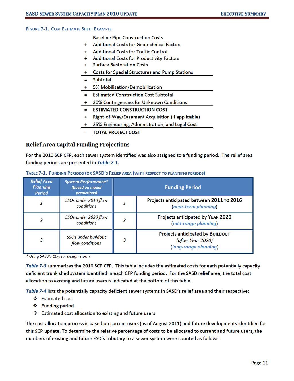
17 SASD SEWER SYSTEM CAPACITY PLAN 2010 UPDATE EXECUTIVE SUMMARY TABLE SCP S TRUNK SYSTEM CAPITAL FUNDING PROJECTIONS Page 13


18 SASD SEWER SYSTEM CAPACITY PLAN 2010 UPDATE EXECUTIVE SUMMARY TABLE 7-4. SASD RELIEF AREA: POTENTIALLY CAPACITY DEFICIENT SEWER SYSTEMS Page 14
2.0 PROJECT DESCRIPTION
 2.0 PROJECT DESCRIPTION 2.1 PROJECT LOCATION The proposed Arboretum project (hereafter referred to as the proposed project ) is located on 1,349 acres within the Grant Line North Planning Area of the City
4.0 INTRODUCTION TO THE ENVIRONMENTAL ANALYSIS AND ASSUMPTIONS USED
 The following is an introduction to the environmental analysis of project-specific and cumulative impacts and general assumptions used in the analysis. The reader is referred to the individual technical
COUNTY OF SACRAMENTO CALIFORNIA PLANNING COMMISSION REPORT
 COUNTY OF SACRAMENTO CALIFORNIA PLANNING COMMISSION REPORT TO: FROM: SUBJECT: COUNTY PLANNING COMMISSION DEPARTMENT OF COMMUNITY DEVELOPMENT GROWTH AREA PLANS UPDATE CONTACT: Cindy Storelli, Principal
Figure 1 Cypress Street Study Area Location Map
 July 20, 2016 TO: FROM: Jim Massarelli Director of Engineering Jeff Julkowski, PE Michael Burke, PE SUBJECT: Cypress Street Study Area Stormwater Analysis (CBBEL Project No. 16-0058) At the request of
Glenborough at Easton Land Use Master Plan
 Vision Statement Sunrise Blvd. Hazel Ave. Prairie City Rd. Gencorp Property Lincoln Regional Airport 1.0 VISION STATEMENT The identifies City of the principles, goals, policies, and standards Lincoln that
Village of Forest Park. July 27, Sewer Separation Evaluation
 Village of Forest Park July 27, 2015 Sewer Separation Evaluation Presentation Overview Study Background Historic Nature of Forest Park Drainage Scale of Flooding Problem Forest Park Sewer System Background
NEWBRIDGE SPECIFIC PLAN PROJECT DESCRIPTION SEPTEMBER 24, 2012
 PROJECT DESCRIPTION SEPTEMBER 24, 2012 Project Location The NewBridge Specific Plan project area consists of 1,095.3 acres south of Mather Airport between Kiefer Boulevard and Jackson Road, west of Sunrise
Easton. Smart Growth Through Innovation. Easton
 Hazel Ave. Sunrise Blvd. Prairie City Rd. Smart Growth Through Innovation offers a unique opportunity to meet the region s future need for jobs and housing. It embodies smart growth principles advocated
HEALTH SCIENCES BUILDING REDEVELOPMENT PROJECT
 INTRODUCTION In recent years, the University of Cincinnati (University) has demonstrated a commitment to identifying and implementing sustainable goals and objectives throughout University s Uptown Campuses.
Department of Community Development. Planning and Environmental Review Division Revised Notice of Preparation
 Department of Community Development Michael J. Penrose, Acting Director Divisions Building Permits & Inspection Code Enforcement County Engineering Economic Development & Marketing Planning & Environmental
South Bismarck Watershed Model Update and Stormwater Improvement Project
 Preliminary Engineering Report Bismarck Tribune South Bismarck Watershed Model Update and Stormwater Improvement Project City of Bismarck, ND January 2017 14.105.0046 1.0 Executive Summary The focus of
3.0 PROJECT DESCRIPTION
 3.0 PROJECT DESCRIPTION This section of the Draft Environmental Impact Report (Draft EIR) is the Project Description of the proposed General Plan. The purpose of the Project Description is to describe
Three Rivers Park District Administration Center Rain Garden
 Three Rivers Park District Administration Center Rain Garden Introduction There are significant changes to the hydrologic regime and nutrient loading following urban and industrial development. The post-development
C. WATER. 1. Surface Water Runoff. See Section C.3, Flood Hazard/Mudflow Hazard, page Ground Water
 C. WATER 1. Surface Water Runoff See Section C.3, Flood Hazard/Mudflow Hazard, page 67. 2. Ground Water Determined not significant by the October 1984 and January 1999 Initial Studies conducted by the
Heights, Elk Grove, Folsom, Galt, Rancho Cordova and Sacramento. For more information, see the Glossary.
 1 Introduction Purpose This Stormwater Quality Design Manual for the Sacramento and South Placer Regions (manual) outlines planning tools and requirements to reduce urban runoff pollution to the maximum
Land Use element LAND USE POLICY AREAS ESTATE AND RURAL RESIDENTIAL AREAS/RURAL SHELDON AREA OLD TOWN ELK GROVE
 Land Use element Land Use is often considered the heart of the General Plan. The statement of future land uses describes how the City believes it should develop in the future where housing, shopping, open
DISCUSSION ON VACAVILLE S2 INVESTORS PROPERTY IN URBAN RESERVE
 Agenda Item No. 9C April 25, 2017 TO: FROM: SUBJECT: Honorable Mayor and City Council Attention: Jeremy Craig, Interim City Manager Barton Brierley, AICP, Community Development Director (Staff Contact:
Table of Contents G.1.a Water Resources - Surface Water - Drainage
 Table of Contents G.1.a Water Resources - Surface Water - Drainage 1. INTRODUCTION... 1335 2. ENVIRONMENTAL SETTING... 1335 a. Regional Hydrology... 1335 b. Local Hydrology... 1337 c. On-site Hydrology...
October 7, City of Thornton 9500 Civic Center Drive Thornton, CO (303) RE: Maverik Thornton, CO - Drainage Report
 RE: Maverik Thornton, CO - Drainage Report") October 7, 2016 City of Thornton 9500 Civic Center Drive Thornton, CO 80229 (303) 538-7295 RE: Maverik Thornton, CO - Drainage Report As per your request, we are submitting to you the drainage report and
October 7, 2016 City of Thornton 9500 Civic Center Drive Thornton, CO 80229 (303) 538-7295 RE: Maverik Thornton, CO - Drainage Report As per your request, we are submitting to you the drainage report and
Request for Statement of Interest in Implementation of the Roosevelt Road Redevelopment Plan
 425 Hillside Avenue Request for Statement of Interest in Implementation of the Roosevelt Road Redevelopment Plan I. INTRODUCTION The is seeking the services of a qualified consulting firm to prepare plans
ACTION SUMMARY VINEYARD CPAC Smedberg Middle School Library 8239 Kingsbridge Drive Sacramento, CA 95829
 ACTION SUMMARY VINEYARD CPAC Smedberg Middle School Library 8239 Kingsbridge Drive Sacramento, CA 95829 TUESDAY August 7, 2018 7:00 PM MEMBERS: JOHN COSTA(CHAIR), BARTLEY BAER(VICE-CHAIR), SOPHIA TROTTER-GOETZE(SECRETARY),
13. PRELIMINARY PLAT NO MILLS FARM - Vicinity of the southeast corner of 159 th Street and Quivira Road
 13. corner of 159 th Street and Quivira Road 1. APPLICANT: HNTB Corporation is the applicant for this request. 2. REQUESTED ACTION: The applicant is requesting approval of a preliminary plat for a 383-lot
CORDOVA HILLS COMPLIANCE WITH THE SACRAMENTO COUNTY GROWTH MANAGEMENT STRATEGY CRITERIA NOVEMBER 2011
 CORDOVA HILLS COMPLIANCE WITH THE SACRAMENTO COUNTY GROWTH MANAGEMENT STRATEGY CRITERIA NOVEMBER 2011 I. ACCEPTANCE OF CORDOVA HILLS APPLICATION TO EXPAND THE UPA: The application for the processing of
4. UTILITIES ELEMENT.
 4. UTILITIES ELEMENT. The purpose of this element is to provide for necessary public facilities and services correlated to future land use projections and population demand. Utilities Sub-Elements (A)
COUNTY OF SACRAMENTO Inter-Departmental Correspondence
 COUNTY OF SACRAMENTO Inter-Departmental Correspondence For the Agenda of December 10, 2003 To: From: BOARD OF SUPERVISORS PLANNING AND COMMUNITY DEVELOPMENT DEPARTMENT Subject: WORKSHOP ON THE FLORIN-VINEYARD
1.0 VISION STATEMENT. December 6, PRINCIPLES
 Vision Statement Lincoln Regional Airport 1.0 VISION STATEMENT 1.1 City LOCATION of AND OVERVIEW The Easton Lincoln Place Land Use Master Plan identifies the principles, goals, policies, and standards
Natomas Joint Vision Open Space Plan
 Natomas Joint Vision Open Space Plan First Workshop series The City of Sacramento The County of Sacramento LAFCo ERA Economic Research Associates EIP Associates a Division of PBS & J Natomas Joint Vision
6 Growth Management Challenges and Opportunities
 6 Growth Management Challenges and Opportunities The Town has established a goal of attaining a 50% participation rate with respect to employment opportunities versus residential population. The Town s
Huntington Stormwater Utility
 Huntington Stormwater Utility Stormwater Management & Sediment and Erosion Control Requirements for Construction Sites Authorized by Huntington City Code Articles: 971, 970, 930, 935, 955, Revised April
DEPARTMENT OF COMMUNITY DEVELOPMENT Planning and Environmental Review Division DRAFT NOTICE OF PREPARATION
 Department of Community Development Lori A. Moss, Director Divisions Building Permits & Inspection Code Enforcement County Engineering Economic Development & Marketing Planning & Environmental Review [CLICK
East Corridor Final Environmental Impact Statement
 East Corridor Final Environmental Impact Statement Alternatives Considered Operating Plan The requirements for opening day operations versus year 2030 are based on ridership and operations. Opening day
7 PUBLIC SERVICES ELEMENT
 7 PUBLIC SERVICES ELEMENT 7.1 PURPOSE The (RDOSP) will provide public services necessary to meet the needs of the Plan Area residents, in accordance with the policies of the City of Rancho Cordova s General
Chapter 1. Introduction
 Chapter 1. Introduction Purpose This (manual) outlines planning tools and requirements to reduce urban runoff pollution to the maximum extent practicable (MEP) from new development and redevelopment projects.
Scope of Services. River Oaks Boulevard (SH 183) Corridor Master Plan
 Corridor Master Plan") Scope of Services River Oaks Boulevard (SH 183) Corridor Master Plan PROJECT AREA The project area consists of the River Oaks Boulevard (SH 183) corridor bounded by SH 199 at the northern end and the Trinity
Scope of Services River Oaks Boulevard (SH 183) Corridor Master Plan PROJECT AREA The project area consists of the River Oaks Boulevard (SH 183) corridor bounded by SH 199 at the northern end and the Trinity
Jackson Highway Master Plans
 Jackson Highway Master Plans West Jackson Highway Master Plan (PLNP2008-00240) Jackson Township Specific Plan (PLNP2011-00095) NewBridge Specific Plan (PLNP2010-00081) Mather South Community Master Plan
7700 College Town Drive, Suite Ninth Street, Suite 212 Sacramento, CA Sacramento, CA 95814
 ACKNOWLEDGEMENTS/PROJECT TEAM: Property Owners Representative: The Hodgson Company John Lambeth 7700 College Town Drive, Suite 220 1025 Ninth Street, Suite 212 Sacramento, CA 95826 Sacramento, CA 95814
Land Use Element. policy areas are discussed in this Element:
 Land Use Element Land Use is often considered the heart of the General Plan. The statement of future land uses describes how the City believes it should develop in the future where housing, shopping, open
Introduction T. This Background Report does not include goals, policies, or programs
 T his Background Report is an integral part of the Elk Grove General Plan. Its purpose is to provide the public, the City s decision-makers, and other agencies with a compendium of information about Elk
Bostwick Road. Municipal Class Environmental Assessment. Public Information Centre #2 June 14, City of London
 Bostwick Road Municipal Class Environmental Assessment Public Information Centre #2 June 14, 2017 Welcome! Welcome to the 2 nd Public Information Centre for the. Representatives from the and the consulting
USA Addition of South & East Side Residential Parcels. USA Deletion of a Town of Christiana Parcel. Conversion from USA to Limited Service Area
 Village of Rockdale Village of Rockdale 148 Water Street Cambridge, WI 53523 Phone 608.423.1497 Fax 608.423.9694 Urban Service Area (USA) Amendment USA Addition of South & East Side Residential Parcels
DEPARTMENT OF COMMUNITY DEVELOPMENT Planning and Environmental Review Division NOTICE OF PREPARATION
 Department of Community Development Lori A. Moss, Director Divisions Building Permits & Inspection Code Enforcement County Engineering Economic Development & Marketing Planning & Environmental Review SEPTEMBER
& 035; ; ;
 County of Sacramento Community Planning & Development Department 827 7 th Street, Room 230 Sacramento, CA 95814 (916) 874-6141 Planning Application Form This application form is required as part of any
City of Fort Wayne Six-Month Status Report Consent Decree Case # 2:07 cv 00445
 City of Fort Wayne Six-Month Status Report Consent Decree Case # 2:07 cv 00445 Report #19 (March 1, 2017 August 31, 2017) APPENDIX 1 Six-Month Status Report #19 (03/01/2017 08/31/2017) APPENDIX
MASTER PLAN. 201 Planning Concepts. Chapter 2
 Chapter 2 MASTER PLAN 201 Planning Concepts 202 Master Land Use Plan 203 Affordable Housing Program 204 Parks, Open Space, and Recreation Trails 205 Grading Concept 206 Circulation Plan 207 Landscape Concept
This Review Is Divided Into Two Phases:
 Semiahmoo Town Centre Review The purpose of this review: To review the Semiahmoo Town Centre Concept Plan, originally approved in 1993, to ensure that this centre will continue to serve the needs of South
Status Update of Turf Work Order. January 18, 2013 MIDS Workgroup Meeting
 Photo: http://en.wikipedia.org/wiki/file:seededfertilizedlawn.jpg Status Update of Turf Work Order January 18, 2013 MIDS Workgroup Meeting Categories of Turf Credits 1. Impervious Surface Disconnection-turf
PREPARED FOR: PLATTEVIEW ROAD CORRIDOR STUDY EXECUTIVE SUMMARY
 PREPARED FOR: PLATTEVIEW ROAD CORRIDOR STUDY EXECUTIVE SUMMARY SEPTEMBER 2016 Introduction The Platteview Road Corridor Study was led by the Metropolitan Area Planning Agency (MAPA) with assistance from
2.6 Pawtucket. Pawtucket Impervious Cover Map (61.4% Impervious)
") 2.6 Pawtucket Pawtucket Impervious Cover Map (61.4% Impervious) The City of Pawtucket is approximately 8.7 square miles and is heavily residential with some commercial and industrial land. Table 2.14 below
2.6 Pawtucket Pawtucket Impervious Cover Map (61.4% Impervious) The City of Pawtucket is approximately 8.7 square miles and is heavily residential with some commercial and industrial land. Table 2.14 below
CITY OF INVER GROVE HEIGHTS 8150 Barbara Avenue Inver Grove Heights, MN (651) Fax: (651)
 Fax: (651)") CITY OF INVER GROVE HEIGHTS 8150 Barbara Avenue Inver Grove Heights, MN 55077 (651) 450-2545 Fax: (651) 450-2502 www.invergroveheights.org SKETCH PLAN REVIEW APPLICATION FOR THE NORTHWEST AREA OVERLAY
CITY OF INVER GROVE HEIGHTS 8150 Barbara Avenue Inver Grove Heights, MN 55077 (651) 450-2545 Fax: (651) 450-2502 www.invergroveheights.org SKETCH PLAN REVIEW APPLICATION FOR THE NORTHWEST AREA OVERLAY
TO: Mayor & Council DATE: April 12, The Planning and Development Department and the Engineering Department recommend that Council:
 CORPORATE REPORT NO: R080 COUNCIL DATE: April 12, 2010 REGULAR COUNCIL TO: Mayor & Council DATE: April 12, 2010 FROM: SUBJECT: General Manager, Planning and Development General Manager, Engineering Neighbourhood
ARLINGTON COUNTY, VIRGINIA
 ARLINGTON COUNTY, VIRGINIA County Board Agenda Item Meeting of March 10, 2012 DATE: February 29, 2012 SUBJECT: SP #197 SITE PLAN AMENDMENT to add a new condition #25 to allow a new use for a Yoga and Pilates
Vaughan Metropolitan Centre (VMC) Black Creek Renewal CLASS ENVIRONMENTAL ASSESSMENT
 Black Creek Renewal CLASS ENVIRONMENTAL ASSESSMENT") PUBLIC INFORMATION CENTRE Vaughan Metropolitan Centre (VMC) Black Creek Renewal Wednesday, May 10, 2017 6:00 p.m. to 8:00 p.m. Add photo Project Management, Environmental Assessment, Stormwater Management
PUBLIC INFORMATION CENTRE Vaughan Metropolitan Centre (VMC) Black Creek Renewal Wednesday, May 10, 2017 6:00 p.m. to 8:00 p.m. Add photo Project Management, Environmental Assessment, Stormwater Management
Planning Districts INTRODUCTION
 INTRODUCTION To facilitate detailed examination of development prospects for all areas of the community, Delano has been divided into 14 planning districts. The location of these planning districts is
COUNTY OF SACRAMENTO CALIFORNIA
 COUNTY OF SACRAMENTO CALIFORNIA For the Agenda of: December 11, 2012 Timed: 10:15 a.m. To: From: Subject: Supervisorial District: Contact: Board of Supervisors Department of Community Development PLNP2010-00081
COUNTY OF SACRAMENTO CALIFORNIA. PLNP Jackson Township Specific Plan. Workshop And Initiation of Environmental Review Process
 COUNTY OF SACRAMENTO CALIFORNIA #102 For the Agenda of: June 18, 2013 Timed: 2:00 PM To: From: Subject: Supervisorial District(s): Board of Supervisors Department of Community Development PLNP2011-00095.
INFRASTRUCTURE EXISTING INFRASTRUCTURE A. Circulation B. Signals C. Drainage D. Utilities
 7.01. EXISTING INFRASTRUCTURE A. Circulation B. Signals C. Drainage D. Utilities 7.02. PROPOSED INFRASTRUCTURE A. Overall Concept B. Circulation C. Signals D. Drainage 7.03. INFRASTRUCTURE MAP A. Key Infrastructure
Glenborough at Easton Land Use Master Plan
 Implementation 114 9.0 IMPLEMENTATION 9.1 OVERVIEW This chapter summarizes the administrative procedures necessary to implement the proposed land use plan, infrastructure improvements, development standards,
ISO/TR TECHNICAL REPORT. Fire-safety engineering Technical information on methods for evaluating behaviour and movement of people
 TECHNICAL REPORT ISO/TR 16738 First edition 2009-08-01 Fire-safety engineering Technical information on methods for evaluating behaviour and movement of people Ingénierie de la sécurité incendie Informations
INTRODUCTION PLANNING HISTORY
 INTRODUCTION The Upper Rock Creek Master Plan Area lies in the east central part of Montgomery County. The Master Plan Area is adjacent to the City of Rockville to the south, the Olney Planning Area to
1 Parkcenter Drive NWC Howe Ave and University Ave Sacramento, CA
 RECENTLY REMODELED! For further information, contact: The Edwards Company 916.277.8120 301 University Ave, Suite 140 95825 Andrea Sessions andrea@theedwardsco.com Lic # 01434048 Steve Edwards steve@theedwardsco.com
Appendix A. Summary of Key Findings: US Hwy Corridor Study. Retail-Commercial Development Plan Page A-1
 Retail-Commercial Development Plan 2020 Appendix A Summary of Key Findings: US 24-40 Hwy Corridor Study Introduction The US 24-40 Corridor Study was initiated by state, regional, county and city officials
Existing Conditions and Environmental Consequences Floodplains
 3.9 Environmental Consequences 3.8 3.8.1 WHAT ARE FLOODPLAINS? are low-lying areas adjacent to rivers, streams, and other waterbodies that are susceptible to inundation (flooding) during rain events. These
CHAPTER 12 IMPLEMENTATION
 CHAPTER 12 IMPLEMENTATION The 2010 Town of Denton Comprehensive Plan is intended to capture a vision of the future of Denton. As such, it provides a basis for a wide variety of public and private actions
Public Information Centre # 2 Coronation Park Drainage Improvements Town of Oakville Municipal Class Environmental Assessment
 November 26, 2014 Public Information Centre # 2 Coronation Park Drainage Improvements Town of Oakville Municipal Class Environmental Assessment Study Area & Drainage System Legend Coronation Project Park
Section 2 Study Area
 Study Area Section 2 Study Area 2-1 Purpose This section describes the study area of the Update and discusses the existing and future land uses within the study area. 2-2 Location The study area, as shown
Draft Rhode Island Stormwater Design and Installation Standards Manual
 Draft Rhode Island Stormwater Design and Installation Standards Manual Summary The May 2009 Public Review Draft version of the RI Stormwater Design and Installation Standards Manual consists of approximately
Michael D, Harvey, Current Planning Supervisor. This project was originally approved in 2012 by the BOCC and is summarized as follows:
 PLANNING & INSPECTIONS DEPARTMENT Craig N. Benedict, AICP, Director Current Planning (919) 245-2575 (919) 644-3002 (FAX) www.orangecountync.gov 131 W. Margaret Lane Suite 201 P. O. Box 8181 Hillsborough,
A Growing Community Rural Settlement Areas
 Town of Huntsville Official Plan Review - POLICY BACKGROUND PAPER A Growing Community Rural Settlement Areas BACKGROUND: In addition to the fully municipally-serviced Urban Settlement Area and the Hidden
WEFTEC.06. ** City of Caldwell, Idaho
 COST-BENEFIT ANALYSIS OF URBAN STORMWATER RETROFITS AND STREAM DAYLIGHTING USING LOW IMPACT DEVELOPMENT TECHNOLOGIES Sherrill Doran*, Dennis Cannon** * CH2M HILL, 322 East Front Street, Suite 200 Boise,
Storm Water Improvements
 Storm Water Improvements The unusually heavy rain storms this past winter raised community awareness and interest in the City s storm water infrastructure system. Public Works was asked to study the system
Presentation Outline. Southwest Area Plan. Slide 1. Slide 2. Presentation to the Committee of the Whole. September 20, 2011
 Slide 1 Southwest Area Plan Presentation to the Committee of the Whole September 20, 2011 Slide 2 Presentation Outline City-Wide Growth Planning Link Official Plan Policies Current Situation and Projections
Analyzing of Reduction Process of Urban Open Spaces in Process of Cities Development with Emphasis on Crisis Management in Tehran Metropolis
 Journal of Sustainable Development; Vol. 5, No. 9; 2012 ISSN 1913-9063 E-ISSN 1913-9071 Published by Canadian Center of Science and Education Analyzing of Reduction Process of Urban Open Spaces in Process
NORTH BETHANY ELEMENTARY SCHOOL SITE ASSESSMENT
 NORTH BETHANY ELEMENTARY SCHOOL SITE ASSESSMENT Prepared for: Prepared by: October 10, 2014 Page 2 Introduction and Purpose This report provides an assessment of two potential sites for a new elementary
Section 4 BUILDING THE MASTER PLAN
 The Master Plan 33 Section 4 BUILDING THE MASTER PLAN Figure 4:1. A collaborative effort characterized the two design workshops sponsored by DISC to create hypothetical Master Plans for the Towers Property
Methods to Simulate the Impact of BMPs
 LA221 Project Ortega Watershed Demonstration Area, Quito Ecuador Ricardo da Cruz e Sousa Master of Landscape Architecture & Environmental Planning University of California, Berkeley December 2011 Ortega
BRISBANE BAYLANDS INFRASTRUCTURE PLAN FEBRUARY 2011 APPENDIX O DRAFT
 BRISBANE BAYLANDS INFRASTRUCTURE PLAN FEBRUARY 2011 APPENDIX O DRAFT PRELIMINARY STORM DRAIN CALCULATIONS ASSOCIATED WITH BRISBANE BAYLANDS REDEVELOPMENT BRISBANE, CALIFORNIA Prepared by BKF Engineers
SACRAMENTO ENVIRONMENTAL COMMISSION
 SACRAMENTO ENVIRONMENTAL COMMISSION Margie Namba Mark White Robert Bailey Dana Curran, Vice Chair George Buzz Link, Chair Dr. Anthony DeRiggi Eric Rivero- Montes Mark Barry Richard Hunn Dianne Kindermann
Water Master Plan. March Prepared by: Prepared for:
 Water Master Plan March 2016 Prepared by: Prepared for: WATER MASTER PLAN March 2016 Prepared for: Prepared by: WATER MASTER PLAN TABLE OF CONTENTS Page No. CHAPTER 1 INTRODUCTION... 1-1 Introduction...
Ottawa County Parks, Recreation & Open Space Plan. February, 2006
 2006 Ottawa County Parks, Recreation & Open Space Plan February, 2006 TABLE OF CONTENTS ACKNOWLEDGMENTS.................................................... v PLAN ADOPTION..........................................................vi
 Item # Meeting Date: February 27, 2014 AGENDA MEMORANDUM To: From: Planning Commission Sandy Vossler, Planner II, Development Services Department Date: February 26, 2014 Title: The Lanterns Planned Development
CITY OF HOLLY SPRINGS STORMWATER UTILITY FREQUENTLY ASKED QUESTIONS
 CITY OF HOLLY SPRINGS STORMWATER UTILITY FREQUENTLY ASKED QUESTIONS GENERAL What is a Stormwater Utility and why is it needed in Holly Springs? A Stormwater Utility is an entity responsible for the daily
Elk Grove Triangle Special Planning Area
 Elk Grove Triangle Special Planning Area Prepared by City of Elk Grove September 2018 Public Draft Revisions Clean Text (Not Showing Track Changes) This page intentionally left blank Table of Contents
Figure 5. Previously Identified Viable Corridors
 OVERVIEW The Central Florida Expressway Authority (CFX) is evaluating the potential to expand SR 408 from its current eastern terminus along SR 50 to SR 520 in northeastern Orange County, Fl. This new
THREE-YEAR CAPITAL IMPROVEMENT PLAN FY
 THREE-YEAR CAPITAL IMPROVEMENT PLAN FY2016 2018 Annual CIP Development Process Public Works & Engineering Divisions Prepare List of Capital Needs and Recommended Deferred Maintenance Public Works & Engineering
STORM WATER UTILITY FREQUENTLY ASKED QUESTIONS
 STORM WATER UTILITY FREQUENTLY ASKED QUESTIONS In 2007, the City Council adopted Ordinance No. 1155 establishing a storm water utility in the City. No fee structure was adopted at that time. The idea of
In November and December, SACOG staff conducted the following Blueprint Implementation land use activities:
 SACOG Board of Directors Item #18-1-16 Receive & File January 11, 2018 Blueprint Implementation Activities The purpose of this item is to regularly inform the Board of SACOG land use related activities
FY Capital Improvement Program Arroyo Projects
 FY 219-223 Capital Improvement Program FY 218 FY 219 FY 22 FY 221 FY 222 FY 223 1 2 3 4 5 6 7 8 9 1 Hahamongna - Implement Master Plan - Oak Grove Area Improvements (7756) Hahamongna - Implement Master
User s Guide for the BMP Sizing Tool. Revised December 2017
 User s Guide for the BMP Sizing Tool Revised December 2017 Table of Contents Section 1.0 Introduction... 1 Section 2.0 Intended Audience... 2 Section 3.0 Installing and Starting the Application... 2 Section
ROAD CLOSURE AND LAND USE AMENDMENT SILVER SPRINGS (WARD 1) NORTHEAST OF NOSEHILL DRIVE NW AND SILVER SPRINGS ROAD NW BYLAWS 2C2018 AND 29D2018
 NORTHEAST OF NOSEHILL DRIVE NW AND SILVER SPRINGS ROAD NW BYLAWS 2C2018 AND 29D2018") Page 1 of 19 EXECUTIVE SUMMARY This application proposes redesignating two parcels in the community of Silver Springs from Special Purpose Future Urban Development (S-FUD) District and undesignated road
Page 1 of 19 EXECUTIVE SUMMARY This application proposes redesignating two parcels in the community of Silver Springs from Special Purpose Future Urban Development (S-FUD) District and undesignated road
Planning Commission Staff Report June 5, 2008
 Owner/Applicant Taylor Village Sacramento Investments Partners, LP c/o Kim Whitney 1792 Tribute Road #270 Sacramento, CA 95815 Staff Recommendation Planning Commission Staff Report Project: File: Request:
continues in the watershed, additional flood control and water quality / natural system improvements may be required in the future.
 The Duck Pond Watershed is located in northern Hillsborough County in an area in which a number of land and water management issues are currently being addressed by citizen's action groups and state, regional
PCE PRELIMINARY DRAINAGE ANALYSIS REPORT FOR WESTWOOD MIXED USE NEIGHBORHOOD PROJECT 772 NORTH FOREST ROAD TOWN OF AMHERST, ERIE COUNTY, NEW YORK
 PCE PRELIMINARY DRAINAGE ANALYSIS REPORT FOR WESTWOOD MIXED USE NEIGHBORHOOD PROJECT 772 NORTH FOREST ROAD TOWN OF AMHERST, ERIE COUNTY, NEW YORK MAY 19, 2014 Prepared By: Timothy M. Lavocat, P.E., CFM
4.0 ENVIRONMENTAL SETTING, IMPACTS AND MITIGATION MEASURES
 4.0 ENVIRONMENTAL SETTING, IMPACTS AND MITIGATION MEASURES 4.1 LAND USE This section describes the existing land uses in the City of Rancho Cordova Redevelopment Project Area (Project Area), characterizes
CITY of RIDGEFIELD TYPE I DECISION SITE PLAN REVIEW (SPR 99-10) PDM MOLDING INC. PHASE II EXPANSION
 PDM MOLDING INC. PHASE II EXPANSION") Page 1 CITY of RIDGEFIELD TYPE I DECISION SITE PLAN REVIEW (SPR 99-10) PDM MOLDING INC. PHASE II EXPANSION TO: Mayor, and Members of the Ridgefield City Council and Planning Commission FROM: Eric Eisemann
Page 1 CITY of RIDGEFIELD TYPE I DECISION SITE PLAN REVIEW (SPR 99-10) PDM MOLDING INC. PHASE II EXPANSION TO: Mayor, and Members of the Ridgefield City Council and Planning Commission FROM: Eric Eisemann
STORMWATER REPORT FOR WALMART SUPERCENTER STORE # SIOUX FALLS, LINCOLN COUNTY, SOUTH DAKOTA BFA PROJECT NO
 STORMWATER REPORT FOR WALMART SUPERCENTER STORE # 2443-00 SIOUX FALLS, LINCOLN COUNTY, SOUTH DAKOTA BFA PROJECT NO. 3286 March 1, 2012 I hereby certify that this engineering document was prepared by me
C ity of Grande Prairie Development Services Department
 C ity of Grande Prairie Development Services Department FAIRWAY DEVELOPMENT OUTLINE PLAN OP 08 09 Approved April 6, 2009 Prepared by: Focus Corporation Table of Contents 1.0. Introduction 2 3 1.1. Plan
Flooding Hearing: Long and Short Term Strategies
 Services of the San Francisco Public Utilities Commission Flooding Hearing: Long and Short Term Strategies Presentation to San Francisco Board of Supervisors Public Safety and Neighborhood Services Subcommittee
CHECKLIST FOR PHASE II DRAINAGE REPORT
 I. COVER SHEET CHECKLIST FOR PHASE II DRAINAGE REPORT A. Name of Project B. Address C. Owner D. Developer E. Engineer F. Submittal date and revision dates as applicable II. GENERAL LOCATION AND DESCRIPTION
MODEL ACCESS MANAGEMENT PLAN MINNESOTA TRUNK HIGHWAY 7 COMPREHENSIVE PLAN AMENDMENT (HUTCHINSON SEGMENT)
") MODEL ACCESS MANAGEMENT PLAN MINNESOTA TRUNK HIGHWAY 7 (HUTCHINSON SEGMENT) COMPREHENSIVE PLAN AMENDMENT INTRODUCTION. The purpose of this plan is to provide consistent access management in the Trunk
MODEL ACCESS MANAGEMENT PLAN MINNESOTA TRUNK HIGHWAY 7 (HUTCHINSON SEGMENT) COMPREHENSIVE PLAN AMENDMENT INTRODUCTION. The purpose of this plan is to provide consistent access management in the Trunk
ATTACHMENT A 09/12/2011. Attachment A - 1. A. Preliminary Future Transit Station Sub-area
 ATTACHMENT A A. Preliminary Future Transit Station Sub-area The Centers, Corridors and Wedges Growth Framework describes Transit Station Areas, which are sub-areas within Growth Corridors, as areas surrounding