LEADERS IN URBAN TRANSPORT PLANNING. Ahmedabad Urban Development Authority
|
|
|
- Megan Tyler
- 6 years ago
- Views:
Transcription
1 LEADERS IN URBAN TRANSPORT PLANNING Ahmedabad Urban Development Authority


2 Regional Context Gandhinagar Twin City 4 Growth centers and Satellite Towns Sanand SIR, Changodar SIR Dholera SIR, SEZs 2
3 What motivated/helped us Used lessons learnt from other cities and cases for better decision making. Idea of integrated strategic planning and transport management Attempt to understands the complexities of urban transport problems and possible context-sensitive solutions. Recognized the need for integrated mobility planning

4 Learning from the historic Core City Walled City

5 Is it vibrant Commercial Hub?

6 Is it really Pedestrian friendly street?

7 Mixed uses Commercial on GF & Residential on upper floors

8 Is it well managed and easily accessible? Public Spaces Chowks & Plazas

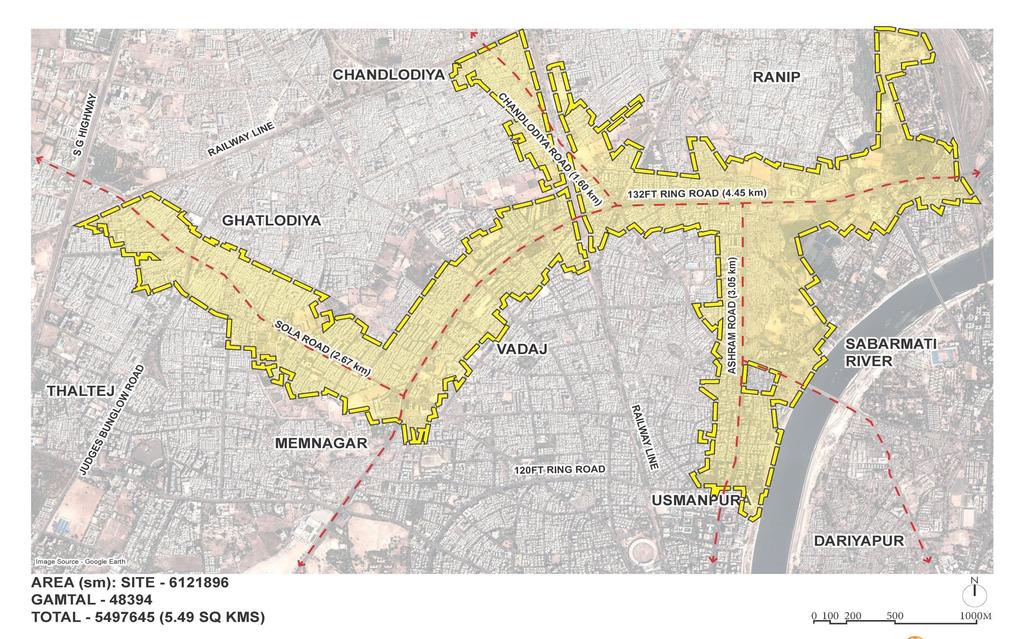
9 Sanctioned Development Plan 2021 (second revised) Published in 2013 Sanctioned in 2014 AUDA Area 1866sqkm 9
10 TOZ FSI 4 CBD FSI 5.4 TOZ FSI 4

11 To meet up the need for integrated mobility planning BRTS Length Kms Buffer Area Sq.Km MRTS Length Kms CBD Area 1.2sqkm
12 Managing Densification of Ahmedabad s Commercial Hub and Mixed-Use Corridors
13 Local Area Plan Planning or redefine the existing developed or undeveloped or developing area in terms of accessibility, walkability, and connectivity as well plan for future infrastructure, amenities and utilites requirements to sustain the future density and growth.
14 The challenge is to ensure that this transformation does not lead to stressed infrastructure or more congestion
15 The Ahmedabad Urban Development Authority and the Ahmedabad Municipal Corporation are developing a plan to meet this challenge
16 How?
17 Planning Initiations Bombay Town Planning Act,1915 (Provided for T.P. Schemes only) 11 TP Schemes 1 st TPS Jamalpur, 1920 Bombay Town planning act, 1954 (DP & T.P. Schemes for Municipal areas) 20 TP Schemes First DP AMC 1965, Revised DP AMC 1983 Gujarat Town Planning & Urban Development Act, 1976 Formation of Area / Urban Development Authority 134 TP Schemes AUDA First DP AUDA 1987, First Revised DP AUDA 2002 Second revision Sanctioned Development Plan Amendment in Gujarat Town Planning & Urban Development Act, Local Area Plan
18 Urban Planning Process 3 tier Planning Process First Tier Development Plan (Macro Level) - AUDA (AUDA+ AMC) Zoning Proposals Regulation for Development City level Transportation and infrastructure planning and implementation Second Tier Town Planning Schemes (Micro Level) - AUDA + AMC Land reconstitution Neighborhood level road network, social and physical infrastructure Financing of neighborhood level infrastructure Third Tier Local Area Plan (Micro Level) - AUDA + AMC
19 Keys to prepare and implement Local Area Plan

20 Transit Corridor Western side
21 Aspects to be considered for Transit Oriented Zone Higher density development Pedestrian friendly streets Green Network Efficient use of front margin Efficient use of ground Higher transit connectivity High intensity of infrastructure Well designed and well managed public parking (On-street & Off-street ) Destine to city tourist places, Economic Centre, Commercial hub and major transit route
22 1. Facilitating the Public Transport 2. Improving walkability by reducing block sizes 3. Expanding the public realm
23 UNDERSTANDING THE AREA

24 Local Area Plan TOZ Wadaj
25
26

27 TOZ Part 2 as per Zoning

28 TOZ Part 2 - TPS Map with Reservation

29 TOZ Part 2 Existing Survey

30 TOZ Part 2 Existing Survey

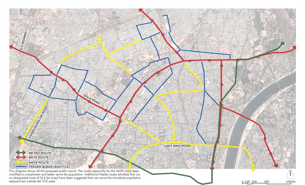
31 Land Use Analysis

32 Ownership Analysis

33 Analysis of Bridges & Infrastructure

34 Building Height Analysis

35 Build form 132 ft. Ring Road

36 Build form Juna Vadaj- Ramapir Tekra- Ashram Road
37 Facilitating the Public Transport

38 Public Transport Total Length: BRTS BRTS Stops & Ridership 4.5 Km.

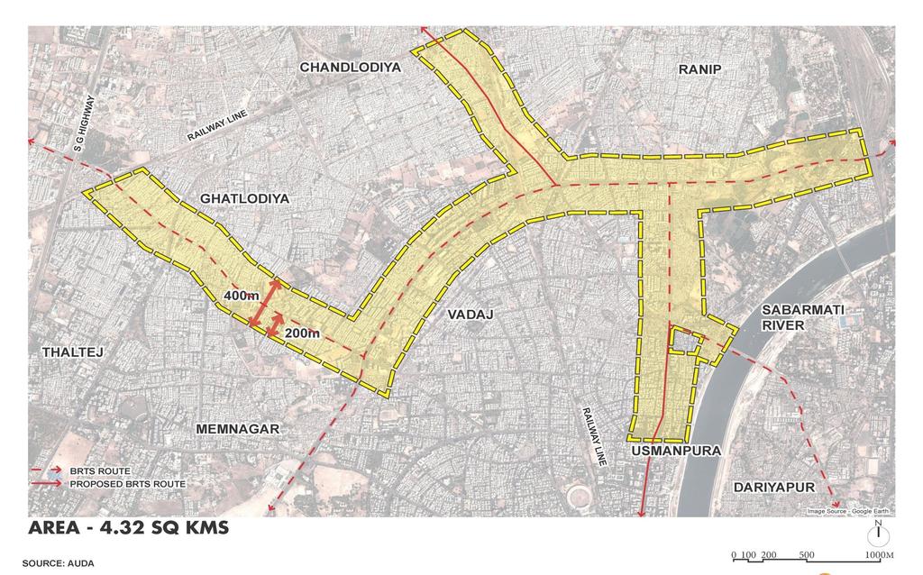
39 AMTS Route

40 MRTS 2.9 Km. Existing Network
41 New Connection

42 Existing BRTS Station BEFORE

43 Propose Plaza at BRTS Station AFTER

44 Propose Schematic View Near MRT Station
45 Improving walkability by reducing block sizes

46 Existing Street Network TOZ Wadaj TOTAL ROUTE 11.77KM TOTAL AREA 4.32 SQKM
47 Existing notified road 18km- Existing road length
48 New Proposed Road- ROW 1
49 New road - Flexible
50 Proposed Network Road Total Length: Total Length of Existing Road Total Length of Proposed Road Future ROW Length: Future ROW-Flexible Length: 24 Km Km. 5.2 Km. 3.9 Km. 1.3 Km.
: 89 Street")
51 No. of Block (Existing): 62 No. of Block (Proposed): 89 Street Hierarchy
52 Expanding the public realm
53 Public domain Public Domain 13.4 Ha.

54 Public domain Public Domain Road width between 12 to 18 mt 3.0 mt Road width > 18 mt 4.5 mt

55 Identifying Public Plaza & Social Infrastructure Plots No. of Plaza: 3 Total Area Under Plaza: 4000sqmt No. of Social Infrastructure Plots: 3 Total Area Under SI: 8390sqmt

56 Existing sections Road sections Proposed sections

57 Existing Junction

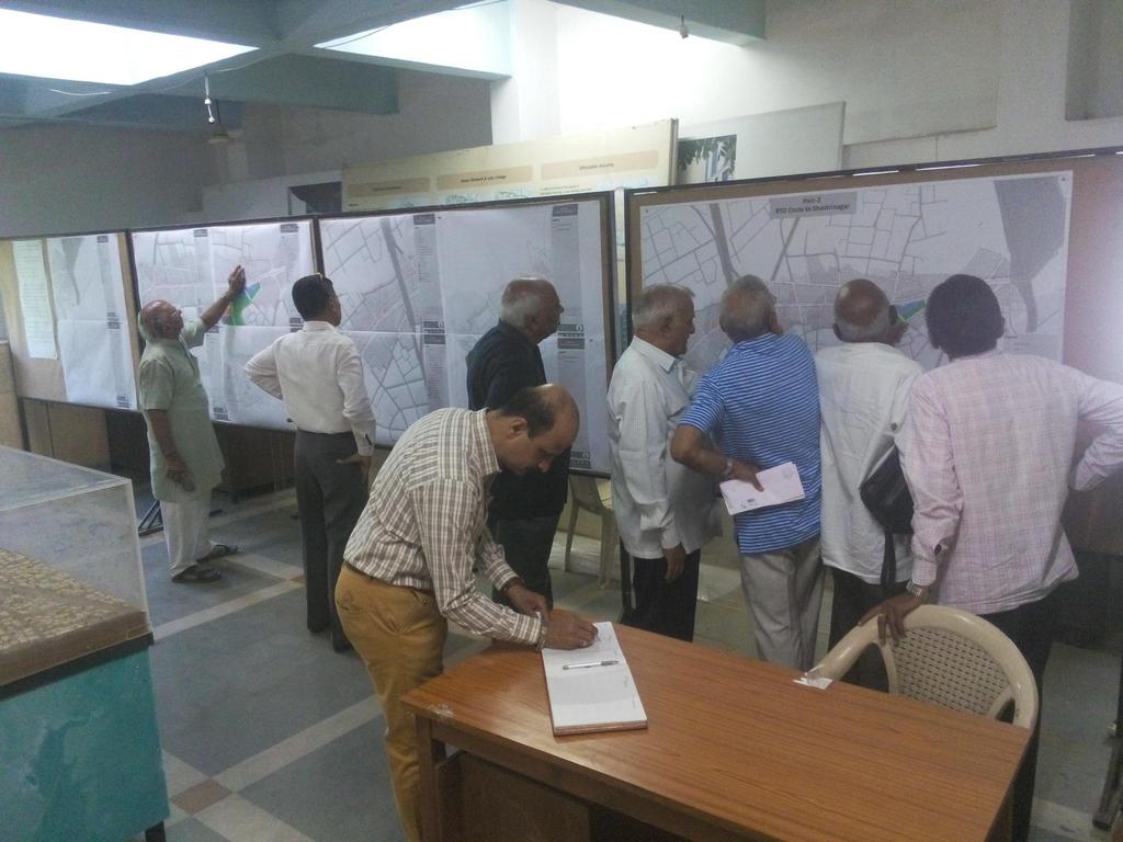
58 Junction Design

59 Alternative 2 -Junction Design

60 Proposal for Special area development - Wadaj

61 Proposal for Special area development - Wadaj


62 Appx sq mt area Land ownership AMC Slum Redevelopment is in process Tenders has been invited Total 800 No of Slum HH shall be shifted within the area Well Integrated Multimodal Hub BRT Proposed Hub GSRTC Prop. Metro 28658sqmt BRTS implemented Metro Under progress GSRTC- Station existing AMTS route existing

63 Proposed Hub
64 Estimated Cost TOZ Part 2
65 Component Estimated Cost (Rs. in cr) 1 Transportation Construction of Roads Street Light 2 Parking Management System 10 intelligent Traffic Management 6 IT Based Junction Design 2 station area development 5 feeder bus connectivity 10 Intermodal hub 125 wifi hotspots 1 surveillance cameras 1 Total Transportation Cost Physical infrastructure Water Supply 29 Sewerage 17 Storm water 14 Solid Waste Management 0 and Acquisition (Rs in lakh) 15 3 Garden and Lake development Garden and Lake development 3 4 Project cost Preparation of detailed plans and studies 3 Total Cost of PROJECTS 245 ADD : 5 % PHYSICAL CONTIGENCIES + WORK CHARGE 12 ADD:150% PRICE ESCALATION FOR 10 YEARS 368 ADD : 10% ADM CHARGES 25 ADD : 20% FOR DEVELOPMENT OF SUROUNDING AREA 49 Total Cost of TOZ (in Cr) 699
66 Owners meeting has been conducted Suggestion and Objections has been discussed and decision has been taken
67
68 Success depend upon three fold careful implementation 1. Proper planning 2. Proper Execution while giving permission 3. Taking possession and initiation of development
 and 3 in CBD area Any structure like ramp/security cabin shall not be permitted in Public Domain area Road RDP")
69 Appx. 121 permission has been given in TOZ area (FSI between 3.0 to 4.0) and 3 in CBD area Any structure like ramp/security cabin shall not be permitted in Public Domain area Road RDP area Public Domain - 6.0mt Ashram Road- Sakar 9

70 Margin area Public domain

71 As per TOZ/CBD GDCR Arcade Public domain
72 Thank You
Integrated Multi Modal Public Transit Hub
 Leaders Programme in Urban Transport Planning and Management Integrated Multi Modal Public Transit Hub at Central Business District- Ahmedabad Neela Munshi (Senior Town Planner) Deepa Dave (AM Urban Planner)
TRANSIT ORIENTED DEVELOPMENT
 TRANSIT ORIENTED DEVELOPMENT Dhaka September 13, 2018 Prof. H. M. Shivanand Swamy Centre of Excellence in Urban Transport Why TOD? Economic Increased Density in prime, Convenient Locations Environmental
SUSTAINABLE TRANSPORT & INTEGRATED LAND USE PLANNING
 SUSTAINABLE TRANSPORT & INTEGRATED LAND USE PLANNING UNESCAP Capacity Building Workshop, Colombo Integrated Land use and Urban Transport Planning : Principles and Practices 31st October 2017 ACTIVE TRANSPORTATION
TOD GUIDANCE DOCUMENT & CITY SPECIFIC PLANS
 National Dissemination Workshop Guidance Documents For Transit Oriented Development (TOD), Non-Motorised Transport (NMT) And Public Bicycle Sharing (PBS) TOD GUIDANCE DOCUMENT & CITY SPECIFIC PLANS IBI
ELMVALE ACRES SHOPPING CENTRE MASTER PLAN
 ELMVALE ACRES SHOPPING CENTRE MASTER PLAN Contents 1.0 INTRODUCTION... 2 2.0 LOCATION... 2 3.0 EXISTING CONTEXT... 2 4.0 VISION & GUIDING PRINCIPLES... 2 5.0 LAND USE AND BUILT FORM... 4 5.1 St. Laurent
MPD 2021 Review TOD Policy
 MPD 2021 Review TOD Policy CURRENT CITY PATTERN: Population Density evenly distributed all over city. Large Travel distances & pollution due to segregated land use and vehicular dependency. Rohtak Road
Subarea 4 Indian Creek. Vision The combination of park networks and transportation amenities make Subarea 4 the greenest hub in the Corridor.
 indian creek 180 extends south from 101st Street to I-435. The I-435 and Metcalf intersection is one of the primary intersections in the Kansas City Metro Area. The area includes several residential neighborhoods
CHAPTER 7: Transportation, Mobility and Circulation
 AGLE AREA COMMUNITY Plan CHAPTER 7 CHAPTER 7: Transportation, Mobility and Circulation Transportation, Mobility and Circulation The purpose of the Transportation, Mobility and Circulation Chapter is to
Ryoko Iizuka Finance, Economics and Urban Department
 THE WORLD BANK www.worldbank.org/eco2 Eco 2 Cities Guide Ryoko Iizuka Finance, Economics and Urban Department 09.12.2011 1 Challenge: How? The 350 page Eco 2 Book elaborates on the principles, methods
MONTGOMERY COUNTY METRO STATION AREA DESIGN CHARRETTE
 MONTGOMERY COUNTY METRO STATION AREA DESIGN CHARRETTE Shady Grove Metro Station Area Charrette Closing Presentation October 25-28, 2000 MONTGOMERY COUNTY, MD M-NCPPC Design Collective, Inc. Architects
Eglinton West LRT Update
 Eglinton West LRT Update Community Consultation Update May 16, 2016 Background Rapid transit along Eglinton Ave between Kennedy Station and Pearson Airport was included in the Metrolinx Regional Transportation
ARCHITECTURE AND PLANNING
 ARCHITECTURE AND PLANNING Subject Code: AR Course Structure Sections/Units Topics Section A Section B Section C Section D Section E Section F Section G Section H Architecture and Design Building Materials,
«Corridor» designs in town planning : Sustainable planning for large cities in developed countries
 CODATU XIII «Corridor» designs in town planning : Sustainable planning for large cities in developed countries Challenges of implementation in booming cities in emerging and developing countries Lyon Town
Northwest commuter rail station US 36 BRT. Westminster Station
 Northwest commuter rail station Westminster Station US 36 BRT Westminster Center US 36 & Church Ranch Broomfield Flatiron/96 th St. US 36 & McCaslin Table Mesa Boulder Junction 13-month effort that will
Plano Tomorrow Vision and Policies
 Plano Tomorrow Vision and Policies PLANO TOMORROW PILLARS The Built Environment The Social Environment The Natural Environment The Economic Environment Land Use and Urban Design Transportation Housing
This Review Is Divided Into Two Phases:
 Semiahmoo Town Centre Review The purpose of this review: To review the Semiahmoo Town Centre Concept Plan, originally approved in 1993, to ensure that this centre will continue to serve the needs of South
REVIEW AND EVALUATION OF REGIONAL LAND USE
 REVIEW AND EVALUATION OF REGIONAL LAND USE AND TRANSPORTATION SCENARIOS #220831 Environmental Justice Task Force October 7, 2014 VISION 2050 Process Development of Guiding Vision for Land Use and Transportation
1.4 TRANSIT VISION 2040 FROM VISION TO ACTION THEME 1: PUTTING TRANSIT AT THE CENTRE OF COMMUNITIES. Fully integrate transit with community design
 TRANSIT VISION 2040 FROM VISION TO ACTION TRANSIT VISION 2040 defines a future in which public transit maximizes its contribution to quality of life with benefits that support a vibrant and equitable society,
Sabarmati Riverfront Development Integrated Environmental Improvement and Urban Revitalization
 Sabarmati Riverfront Development Integrated Environmental Improvement and Urban Revitalization Ahmedabad and the Sabarmati Ahmedabad was established on Sabarmati in 1411 Painting: Amit Ambalal Ahmedabad
The Neighbourhood Unit
 DESIGN... Site Framework PROCESS IMPLEMENTATION 22 TOOL DESCRIPTION The neighbourhood unit is a holistic planning and design strategy that addresses the configuration of the major physical components of
Welcome to the Oakridge Centre Open House
 Welcome to the Oakridge Centre Open House Why is the City hosting this event? This open house is to inform you of a rezoning application submitted to the City of Vancouver to amend the existing CD-1 (Comprehensive
Complete Neighbourhood Guidelines Review Tool
 Complete Neighbourhood Guidelines Review Tool Prepared By: City of Regina Planning Department October 2014 Page 1 of 14 Community Development Review Checklist for Secondary Plans and Concept Plans The
Gold Line Bus Rapid Transit Transit Oriented Development (BRTOD) Helmo Station Area Plan
 Helmo Station Area Plan") Appendix F Gold Line Bus Rapid Transit Transit Oriented Development (BRTOD) Helmo Station Area Plan Introduction and Purpose of the Plan The Gold Line Bus Rapid Transit facility is an eleven-mile dedicated
Appendix F Gold Line Bus Rapid Transit Transit Oriented Development (BRTOD) Helmo Station Area Plan Introduction and Purpose of the Plan The Gold Line Bus Rapid Transit facility is an eleven-mile dedicated
Create Policy Options Draft Plan Plan Approval. Public Consultation Events. Phase 2
 Background Grandview-Woodland Community Plan In the spring of 2012, the City of Vancouver embarked on a comprehensive community planning program in the Grandview-Woodland neighbourhood. The process has
APPENDICES DESIGNING PUBLIC SPACES - ENERGIZED PUBLIC SPACES DESIGN GUIDELINES WORKING DRAFT DECEMBER 2018 A1
 APPENDICES DESIGNING PUBLIC SPACES - ENERGIZED PUBLIC SPACES DESIGN GUIDELINES WORKING DRAFT DECEMBER 2018 A1 App.1 Case Studies by Park Types The upcoming (in-progress) online library will house several
Broadway District Specific Plan. Community Workshop #2 February 23,2016
 Broadway District Specific Plan Community Workshop #2 February 23,2016 1 Agenda Introductions Project Progress Status Upcoming Milestones Emerging Framework Land Use Urban Design Circulation Infrastructure
Delhi May 6-7, Paper to be published in Urban Update during South Asian Cities Summit organized by AIILSG and UCLG, New
 1 FINANCING FOR SMART CITY MISSION 1 Chetan Vaidya Director SPA Delhi Background: The Government has launched number of urban missions including the one on Smart Cities. Mission will cover 100 cities over
Transit / Housing Oriented Redevelopment
 Broward County Urban Planning and Redevelopment Department Kick-Off Meeting October 24, 2007 Transit / Housing Oriented Redevelopment 1 Future Land Use 2 Broward County Charter Voters approved in 1974.
Railway Station Multimodal Hub Project, Bhubaneswar
 Railway Station Multimodal Hub Project, Bhubaneswar RAILWAY STATION MIXED USE TOWER CONVENTION/RETAIL PUBLIC PLAZA PRESENTATION OUTLINE PROJECT AREA PROJECT FEATURES SALIENT FEATURES of MoU PRESENT STATUS
ROBBINSDALE LRT STATION CDI DEVELOPMENT GUIDELINES
 August 2018 OVERVIEW The City of Robbinsdale has a prime-opportunity site in the middle of the 13 mile stretch of the Bottineau LRT corridor / Blue Line extension. Robbinsdale offers a prominent, vital,
Developer s Program. The Station at East 54
 Developer s Program The Station at East 54 Existing Conditions The Station at East 54 is proposed for a 1.12 acre site at the northeast corner of Hamilton Road and Prestwick Road, tucked between the East
TOD strategy in LAC Region
 HOW TRANSIT ORIENTED DEVELOPMENT -TOD -COULD TRANSFORM URBAN SPACE Vanessa Velasco, Urban Specialist. welascobernal@worldbank.org Source: Metro Sabana,2017 TOD strategy in LAC Region 1. TOD context 2.
PILLAR FOUR INTEGRATE LAND USE & TRANSPORTATION
 PILLAR FOUR INTEGRATE LAND USE & TRANSPORTATION 8 Scarborough Centre on the Move Transportation Master Plan 123 8 Transportation Pillar Four Integrate Land Use & The fourth pillar focuses on the relationship
Subregion 4 Central Avenue-Metro Blue Line Corridor Transit-Oriented Development (TOD) Implementation Project. Community Meeting April 27, 2011
 Implementation Project. Community Meeting April 27, 2011") Subregion 4 Central Avenue-Metro Blue Line Corridor Transit-Oriented Development (TOD) Implementation Project Community Meeting April 27, 2011 Overview Introduction to Subregion 4 TOD Implementation Program
Subregion 4 Central Avenue-Metro Blue Line Corridor Transit-Oriented Development (TOD) Implementation Project Community Meeting April 27, 2011 Overview Introduction to Subregion 4 TOD Implementation Program
Isabel Neighborhood Plan: Alternatives
 Isabel Neighborhood Plan: Alternatives Presented by: Lori Parks, Associate Planner February 2, 2015 Agenda 1. Background on BART to Livermore 2. Isabel Neighborhood Plan 3. Alternative Scenarios 4. General
D-O LRT Zoning Discussion. Chapel Hill Boards & Commissions October 16, 2017
 D-O LRT Zoning Discussion Chapel Hill Boards & Commissions October 16, 2017 Update on Overall D-O LRT Station Area Initiative Objectives Design and educate on principles of Good Transit-Oriented Development
Official Plan Review
 Official Plan Review Summary Report - The Built Environment August 2014 Part 1: Introduction Planning for a healthy, prosperous and sustainable community is an important goal for our municipality. From
Robbinsdale LRT Station. CDI Development Guidelines. August Overview
 Robbinsdale LRT Station August 2018 Overview The City of Robbinsdale may have the coolest opportunity site along the 13 mile stretch of the Bottineau LRT corridor / Blue Line extension. Located a block
Integrated Urban Development. April Reflections from the NZPI Study Tour of Portland, Seattle and Vancouver
 Integrated Urban Development April 2009 Reflections from the NZPI Study Tour of Portland, Seattle and Vancouver Integrated Urban Development Urban Growth Management Transportation Transit Orientated Mixed
DRAFT Land Use Chapter
 Stevens Creek Urban Village DRAFT 1 18 17 Land Use Chapter INTRODUCTION This Land Use Chapter describes how the Stevens Creek Urban Village will accommodate the growth that is planned for it in the Envision
City of Hermosa Beach Administrative Policy #
 City of Hermosa Beach Administrative Policy # SUBJECT: Living Streets Policy Date: Approved by: City Council Authority: Public Works Department & Community Development Department Mayor, PURPOSE The City
EXHIBIT A. Tax Increment Reinvestment Zone No. 1 (Town Center) First Amended Project Plan 1
 First Amended Project Plan 1") EXHIBIT A Tax Increment Reinvestment Zone No. 1 (Town Center) First Amended Project Plan 1 1 As amended by Resolution No. 2008-02-001(TR1R) of the Tax Increment Reinvestment Zone No.1, and approved to
EXHIBIT A Tax Increment Reinvestment Zone No. 1 (Town Center) First Amended Project Plan 1 1 As amended by Resolution No. 2008-02-001(TR1R) of the Tax Increment Reinvestment Zone No.1, and approved to
TOWN OF NEW CASTLE - Master Plan Update
 Our Presentation Today (1) Recap the Master Planning Process To Date (2) Present the Outline of the Master Planning Work Plan (3) Present the Calendar for the Master Plan (4) Outline the scope of a Downtown
PLAN ELEMENTS WORKSHOP. April 5, 2016
 PLAN ELEMENTS WORKSHOP April 5, 2016 needs more housing. But there is no one-size fits-all solution. Every neighborhood has its own character. In some places, density is not only appropriate it is badly
Land Use/Transport Integration. Land Use as an end Transport as a means
 Copenhagen s Finger Plan Land Use/Transport Integration Land Use as an end Transport as a means Smart Growth Land Use Transport Contrasting Models of Transit & Development Adaptive Cities: built forms
Employment and Commercial Review Analysis of Policy Directions
 Employment and Commercial Review Analysis of Policy Directions Appendix A The following analysis is town staff s response to the policy directions provided by the consultants who prepared the Employment
Social Screening and Impact Assessment for Sub Projects
 Social Screening and Impact Assessment for Sub Projects Code No: 7 A. Sub Project Description: Rehabilitation of McCallum Lock Gates and Construction of Bank Protection Wall with Linear Walk Around Beira
Presentation for Terms of Reference (TOR) before the Esteemed Members of SARTHAV INFRASTRUCTURE PVT. LTD.
 before the Esteemed Members of SARTHAV INFRASTRUCTURE PVT. LTD.") Presentation for Terms of Reference (TOR) before the Esteemed Members of STATE EXPERT APPRAISAL COMMITTEE 1, AHMEDABAD COMPLETED COMMERCIAL OFFICE/ CORPORATE PARK Locality Aambli Bopal Road District Ahmedabad
Presentation for Terms of Reference (TOR) before the Esteemed Members of STATE EXPERT APPRAISAL COMMITTEE 1, AHMEDABAD COMPLETED COMMERCIAL OFFICE/ CORPORATE PARK Locality Aambli Bopal Road District Ahmedabad
Unique. Livable. Connected. Sustainable. Anticipate and Manage Change. Variety of Housing Choices. Enhanced Arterial Corridors
 Neighborhood Vision The Old Town Neighborhoods are Unique, Livable, Connected, and Sustainable. As mature, established neighborhoods, many of the ideas and opportunities expressed by stakeholders in support
Urban Planning and Land Use
 Urban Planning and Land Use 701 North 7 th Street, Room 423 Phone: (913) 573-5750 Kansas City, Kansas 66101 Fax: (913) 573-5796 Email: planninginfo@wycokck.org www.wycokck.org/planning To: From: City Planning
PSRC REVIEW REPORT & CERTIFICATION RECOMMENDATION
 PSRC REVIEW REPORT & CERTIFICATION RECOMMENDATION KITSAP COUNTY COUNTYWIDE PLANNING POLICIES July 2, 2012 BACKGROUND A major emphasis of the Washington State Growth Management Act (GMA) is the need to
South Davis County COMMUNITY SPOTLIGHT
 South Davis County COMMUNITY SPOTLIGHT Davis/SLC Community Connector Bus Rapid Transit line connecting SLC & Davis County RTP Phase 1 Project Generate 3,100 average weekday riders Relieve congestion on
1.0 Purpose of a Secondary Plan for the Masonville Transit Village
 Report to Planning and Environment Committee To: Chair and Members Planning & Environment Committee From: John M. Fleming Managing Director, Planning and City Planner Subject: Masonville Transit Village
KANPUR 5 LAND USE Final Report: Kanpur City Development Plan Under JNNURM
 5 LAND USE The process of planned development for Kanpur city was started way back in 1943 when Kanpur Development Board has prepared the first development plan. With the change in socio-economic situation
Transportation. Strategies for Action
 Transportation A major priority for the Overlake Neighborhood is to develop a multimodal transportation system. To achieve this system, a balance has to be found among travel, circulation and access needs;
Implementation Guide Comprehensive Plan City of Allen
 Implementation Guide 2030 Comprehensive Plan City of Allen DRAFT 2015 Implementation Guide Allen 2030 Comprehensive Plan INTRODUCTION The Comprehensive Plan serves as a guide for the growth and development
3. Endorse the LRT vision in transforming Surrey into Connected-Complete-Livable communities, and more specifically, the official vision statement:
 CORPORATE REPORT NO: R038 COUNCIL DATE: February 20, 2017 REGULAR COUNCIL TO: Mayor & Council DATE: February 16, 2017 FROM: General Manager, Engineering FILE: 8740-01 SUBJECT: Surrey Light Rail Transit
Midtown Greenway Land Use and Development Plan Executive Summary
 Midtown Greenway Land Use and Development Plan Executive Summary Introduction The Midtown Greenway Land Use and Development Plan sets policy direction for land use and development in the Midtown Greenway
City of Fort Lauderdale UPTOWN URBAN VILLAGE. Public Workshop December 7, 2016
 Public Workshop December 7, 2016 Workshop Agenda Introductions Project Presentation o o o History Project Scope/Timeline Character of Study Area o o o o Land Use Public Realm/Pedestrian Mobility Multimodal
Corridor-Level Approaches to Creating Transit-Oriented Districts
 Corridor-Level Approaches to Creating Transit-Oriented Districts Dena Belzer Strategic Economics and Center for Transit-Oriented Development August 2011 5-year old partnership dedicated to improving practice
Riverfront Park. Proposed. Riverfront Market. Park. Gandhi Bridge. Nehru. Bridge
 Riverfront Park Proposed Development Proposed Park Proposed Heritage Plaza Riverfront Market Proposed Cultural Center Sardar Bridge Dr. Ambedkar Bridge Subhash Bridge Dadhichi Rushi Bridge Riverfront Park
Don Mills Crossing Study and Celestica Lands Development Application Community Meeting, Open House, and Breakout Discussions
 Consultation Summary Don Mills Crossing Study and Celestica Lands Development Application Community Meeting, Open House, and Breakout Discussions This report is not intended to provide a verbatim transcript
TABLE OF CONTENTS CHAPTER TITLE PAGE DECLARATION DEDICATION ACKNOWLEDGEMENTS ABSTRACT ABSTRAK
 vii TABLE OF CONTENTS CHAPTER TITLE PAGE DECLARATION DEDICATION ACKNOWLEDGEMENTS ABSTRACT ABSTRAK TABLE OF CONTENTS LIST OF FIGURES LIST OF TABLES LIST OF ACROYMS LIST OF APPENDIXES ii iii iv v vi vii
Urban Design Manual PLANNING AROUND RAPID TRANSIT STATIONS (PARTS) Introduction. Station Study Areas
 Introduction. Station Study Areas") 111111 PLANNING AROUND RAPID TRANSIT STATIONS (PARTS) Introduction The ION rapid transit system will link Waterloo, Kitchener and Cambridge through a central transit corridor (CTC). There are a number
111111 PLANNING AROUND RAPID TRANSIT STATIONS (PARTS) Introduction The ION rapid transit system will link Waterloo, Kitchener and Cambridge through a central transit corridor (CTC). There are a number
WELCOME and introduction
 1 WELCOME and introduction Mobility Hub Locations within Burlington STUDY OVERVIEW STUDY OBJECTIVES The City of Burlington is developing four Area Specific Plans, one for each of Burlington s Mobility
Agenda. Smart city introduction. National and global models. Thoothukudi overview & smart city approach
 Agenda 1 Smart city introduction 2 3 National and global models Thoothukudi overview & smart city approach Smart cities mission Smart cities mission: centrally sponsored scheme of Govt. of India o Envisages
Agenda. 7 Wright Crescent Urban Design Study. Public Meeting and Urban Design Workshop. 1 INTRODUCTION AND BACKGROUND (City of Kingston)
") Urban Design Study Public Meeting and Urban Design Workshop October 02, 2013 Agenda 1 INTRODUCTION AND BACKGROUND (City of Kingston) 2 URBAN DESIGN STUDY PRESENTATION (Antonio Gomez-Palacio, DIALOG) 3
Urban Design Study Public Meeting and Urban Design Workshop October 02, 2013 Agenda 1 INTRODUCTION AND BACKGROUND (City of Kingston) 2 URBAN DESIGN STUDY PRESENTATION (Antonio Gomez-Palacio, DIALOG) 3
Prof. H.M. Shivanand Swamy ExecuCve Director Centre of Excellence in Urban Transport, CEPT University. Landuse / Economic Impacts of BRT Ahmedabad
 Prof. H.M. Shivanand Swamy ExecuCve Director Centre of Excellence in Urban Transport, CEPT University Landuse / Economic Impacts of BRT Ahmedabad 29th September - 01st October 2014 SAVE THE DATES UNESCAP
Living in Albemarle County s Urban Places
 Living in Albemarle County s Urban Places ALBEMARLE COUNTY, VIRGINIA A Closer Look at Albemarle s Approach to Managing Growth and Creating Quality Urban Environments www.albemarle.org Page 2 Living in
Building out the Regional Growth Strategy in Surrey: a Strong Centre & a Connected Transit City
 Building out the Regional Growth Strategy in Surrey: a Strong Centre & a Connected Transit City Surrey in the Metro Vancouver Region Regional Growth Strategy identifies Surrey as a major provider of housing
MAIN STREET ECONOMIC DEVELOPMENT STRATEGY
 MAIN STREET ECONOMIC DEVELOPMENT STRATEGY A PATHWAY TO A BETTER POUGHKEEPSIE DRAFT Working Paper #2: Planning Strategies Submitted December 1 st, 2015 to the City of Poughkeepsie LAND USE LAW CENTER PACE
Annexure 1. STRATEGY for better Urban Form
 Annexure 1 STRATEGY for better Urban Form Demarcate the planning localities Mapping of the city should be carried out to identify the various localities. These localities can be mapped based on similarities
Making TOD Work in the Heart of Suburban Sprawl
 Making TOD Work in the Heart of Suburban Sprawl Rocky Mountain Land Use Institute March 6, 2009 Speakers Ben Herman, FAICP, Principal Clarion Associates Darcie White, AICP, Principal Clarion Associates
Executive Summary. NY 7 / NY 2 Corridor
 Executive Summary NY 7 / NY 2 Corridor Transportation and Land Use Study December 2005 Prepared for: Town of Colonie Capital District Transportation Committee Prepared by: Introduction: Land use decisions
burlington mobility hubs study Downtown Burlington Mobility Hub
 burlington mobility hubs study Downtown Burlington Mobility Hub Draft Precinct Plan Workbook PIC #3, September 7, 2017 downtown mobility hub objectives City staff and their consultants are proposing an
UAA School of Engineering Parking Garage Master Plan Amendment. 1. Purpose
 UAA School of Engineering Parking Garage Master Plan Amendment 1. Purpose Since the UAA campus master plan was drafted in 2003, adopted in 2004, and amended in 2009 a number of significant changes regarding
Description of Preferred Alternative
 Chapter 2 Description of Preferred Alternative 2.1 Introduction This chapter of the programmatic Sammamish Town Center Sub-area Plan Final EIS provides a more detailed description of the Preferred Alternative
TRANSIT NEIGHBORHOOD PLANS PROGRAM OVERVIEW
 TRANSIT NEIGHBORHOOD PLANS PROGRAM OVERVIEW OCTOBER 2017 Los Angeles Department of City Planning @LATNP and @Planning4LA Outline Introduction Policy Framework The Transit Neighborhood Plans Program Overview:
S A C R A M E N T O C O U N T Y JACKSON HIGHWAY & GRANT LINE EAST VISIONING STUDY
 JACKSON HIGHWAY & GRANT LINE EAST S A C R A M E N T O C O U N T Y P L A N N I N G D E P A R T M E N T SUMMARY AND WORKBOOK November 19, 2008 History of the Visioning Study Sacramento County has two growth
Silverdale Regional Center
 Silverdale Regional Center Vision for Silverdale Regional Center The Silverdale Regional Center Plan (Plan) will guide the evolution of the Silverdale Regional Center from a collection of strip malls and
RE-Imagining the Downtown Colorado Springs Master Plan
 RE-Imagining the Downtown Colorado Springs Master Plan 2016 APA Colorado State Conference October 25, 2016 Overview 8:00 Welcome, Introductions, and Overview 8:15 Downtown s Planning History 8:30 A Market
Making the case for Sustainable Transport Project Potential
 Making the case for Sustainable Transport Project Potential The Structural Investment Fund (SIF) Strategy for Greater Lincolnshire identifies the barriers to growth identified by having poor transport
Transport Demand Management (TDM) Policies and Measures for Sustainable Cities
 Policies and Measures for Sustainable Cities") 1 Intergovernmental 11 th Regional Environmentally Sustainable Transport (EST) Forum in Asia 2-5 October 2018, Ulaanbaatar, Mangolita Transport Demand Management (TDM) Policies and Measures for Sustainable
1 Intergovernmental 11 th Regional Environmentally Sustainable Transport (EST) Forum in Asia 2-5 October 2018, Ulaanbaatar, Mangolita Transport Demand Management (TDM) Policies and Measures for Sustainable
BRIDGES, FLYOVERS AND ELEVATED MRTS STRUCTURES
 2016 Edition BRIDGES, FLYOVERS AND ELEVATED MRTS STRUCTURES Trends, Outlook and Projections Research Report Data-set (Excel) Four Quarterly Updates India Infrastructure Research www.indiainfrastructure.com
Rezoning Frequently Asked Questions
 elcome The City of Vancouver has received an application to rezone 6929-6969 Cambie Street and 515 est 54th Avenue from RS-1 (Single Family) District to CD-1 (Comprehensive Development) District. The proposal
LEED-ND 101: Practical Strategies for Achieving Sustainability Goals. Travis Parker Lakewood Planning Director
 LEED-ND 101: Practical Strategies for Achieving Sustainability Goals Travis Parker Lakewood Planning Director Metro Vision Idea Exchange Oct 11, 2012 West Corridor Stations West Corridor Overview West
LAND USE AMENDMENT DOWNTOWN COMMERCIAL CORE (WARD 7) MACLEOD TRAIL SE AND 5 AVENUE SE BYLAW 254D2017
 MACLEOD TRAIL SE AND 5 AVENUE SE BYLAW 254D2017") Page 1 of 10 EXECUTIVE SUMMARY This Land Use Amendment application seeks to redesignate a full downtown block (currently the YWCA site) from a Direct Control based on the CM-2 District (Land Use Bylaw
Page 1 of 10 EXECUTIVE SUMMARY This Land Use Amendment application seeks to redesignate a full downtown block (currently the YWCA site) from a Direct Control based on the CM-2 District (Land Use Bylaw
Shift Rapid Transit Public Participation Meeting May 3, 2017
 Shift Rapid Transit Public Participation Meeting May 3, 2017 Shift Rapid Transit Initiative Largest infrastructure project in the city s history. Rapid Transit initiative will transform London s public
1.3 TRANSIT VISION 2040 FROM VISION TO ACTION THEME 1: PUTTING TRANSIT AT THE CENTRE OF COMMUNITIES. Fully integrate transit with community planning
 TRANSIT VISION 2040 FROM VISION TO ACTION TRANSIT VISION 2040 defines a future in which public transit maximizes its contribution to quality of life with benefits that support a vibrant and equitable society,
PRINCE GEORGE S PLAZA TRANSIT DISTRICT DEVELOPMENT PLAN AND TRANSIT DISTRICT OVERLAY ZONE UPDATE
 PRINCE GEORGE S PLAZA TRANSIT DISTRICT DEVELOPMENT PLAN AND TRANSIT DISTRICT OVERLAY ZONE UPDATE UNIVERSITY PARK TOWN LISTENING SESSION JUNE 12, 2014 Prince George s County Planning Department The Maryland-National
Rio/29 Future Land Use Alternatives. Rio/29 Small Area Plan Phase 1 December 12, 2016
 Rio/29 Future Land Use Alternatives Rio/29 Small Area Plan Phase 1 December 12, 2016 PRESENTATION OVERVIEW 1 BACKGROUND 2 COMMUNITY INPUT 3 DESIGN PRINCIPLES 4 5 ALTERNATIVES OPEN HOUSE 2 1 PROJECT BACKGROUND
Municipal Development Plan Update Urban Service Area and Hamlets
 ENCLOSURE 1 Municipal Development Plan Update Urban Service Area and Hamlets Priorities Committee January 24, 2017 MUNICIPAL DEVELOPMENT PLAN UPDATE SHAPING OUR FUTURE MDP Update - Agenda MDP Update Public
Northeast Ohio Areawide Coordinating Agency. Regional TOD Scorecard and Implementation Plan. July 28, 2016
 Northeast Ohio Areawide Coordinating Agency Regional TOD Scorecard and Implementation Plan July 28, 2016 Agenda Introduction and Overview Wrap-Up of Phase I Task 1: TOD Typology, Metrics, and Scorecard
Connecting Key Activity Centers with High Quality Bus Service
 Connecting Key Activity Centers with High Quality Bus Service Lessons Learned from the DC Circulator Transit Development Plan April 15, 2011 1 DC Circulator Transit Development Plan Ten-year plan for development
Community Design Guidelines. Port Wallace DRAFT
 Community Design Guidelines Port Wallace DRAFT Energy 1 2 3 Nature Movement Connections Built Form DRAFT Layout Energy 1 Nature Community Design Guidelines GREAT COMMUNITIES PROTECT, CELEBRATE, AND CONSERVE
Bethesda Downtown Plan
 Bethesda Downtown Plan Planning Board Update Connecticut Avenue Location Economic Sustainability Social Environmental Scope Coming Soon! Team Listening, Twitter Outreach We Are Here Engagement Challenge
Route 1 Corridor Study
 Route 1 Corridor Study Westbrook, Connecticut A Vision for the Connecticut Shoreline Public Informational Meeting July 28, 2015 Lower Connecticut River Valley Council of Governments Fitzgerald & Halliday,
Planning and designing for sustainable urban transportation systems - An overview. EFFECTIVE URBAN PLANNING - A Key to Ensure Sustainable Development
 Planning and designing for sustainable urban transportation systems - An overview EFFECTIVE URBAN PLANNING - A Key to Ensure Sustainable Development PART 1 CONTEXT 26/03/2013 CoE-UT CEPT University 2 Our
Rio/29 Small Area Plan. Design Plan & Implementation Framework Open House - January 25, 2018
 Rio/29 Small Area Plan Design Plan & Implementation Framework Open House - January 25, 2018 MEETING PURPOSE PRESENTATION 1. Orient to the updated design plans 2. Introduce implementing options 3. Explain
City of Villages Parking Strategies. William Anderson, FAICP City Planning & Community Investment San Diego Parking Symposium July 14, 2006
 City of Villages Parking Strategies William Anderson, FAICP City Planning & Community Investment San Diego Parking Symposium July 14, 2006 City of Villages Strategy A hierarchy of walkable, mixed use districts