Design & Access Statement. West Langarth Urban Development, Truro August 2014
|
|
|
- Sharon Lester
- 5 years ago
- Views:
Transcription

1 Design & Access Statement West Langarth Urban Development, Truro August 2014
2
3 Foreword RETAIL activity This Design and Access Statement explains the outline proposals for a new district centre to the west of the consented masterplan at Langarth. The proposal has a mix of uses including retail (food and comparison), residential (housing and apartments), food and beverage (restaurants), a variety of different public open spaces (including sports pitches), pedestrian routes and improved linkages to the wider development to the east. To ensure a sustainable development is delivered, it is crucial that a range of uses are provided for the site. It is also important that the proposals have a strong and appropriate relationship to the consented Langarth scheme. The proposals relate and integrate to Inox Group and Tetlow King s consented scheme and adhere and enhance the Design Code (Revision K 26th April 2013). The overall design concept closely links the application site to the consented masterplan in the creation of a dumbbell of development. Each end of the dumbbell acts as a district focus. One end of the dumbbell has the stadium and associated uses, the other end is the proposed district centre that forms this application. The new district centre will provide a much needed food store and further retail accommodation for the overall Langarth masterplan and wider community. The new district centre is connected to the established hub of the stadium area with a number of strong and animated vehicular and pedestrian routes. In addition, a variety of much needed public open spaces are provided. A390 STADIUM & LEISURE The public open spaces will have a variety of uses including sports pitches. These facilities will be used by the wider community and echo the sporting and leisure activities that occur within the stadium at the heart of the Langarth masterplan. The proposals have been designed to be sensitive to setting and balance the environmental, ecological, topographical and commercial requirements for the site. This scheme is considered as an enabling development to allow the realisation of the new stadium as part of the Langarth masterplan.

4
5 Contents Foreword 3 Document Structure 7 Team Highways and Access High Pressure Gas Main Integration with Langarth Masterplan DEVELOPMENT OVERVIEW & VISION Overview and Vision Cornwall Design Guide Development Principles ANALYSIS Truro The Site and its Surrounding Location The Site Truro s Location Flooding Movement Access into Truro Access around the Site Facilities Heritage Existing Architectural Character CONSTRAINTS & OPPORTUNITIES Constraints and Opportunities Landscape Features Gradients and Geology Visual Impact and Relationship to Landscape Ecology Acoustics DESIGN DEVELOPMENT & PREFERRED LAYOUT Use and Content Socio-Economic Assessment Sustainable Design Solution Design Development Preferred layout CHARACTER AREAS Character Area 1 - District Centre Character Area 2 - West Langarth Residential Character Area 3 - Community Playing Pitches Character Area 4 - Landscape Heights RELATIONSHIP TO CONSENTED MASTERPLAN FOR LANGARTH SUMMARY APPENDIX 140

6
7 Document Structure The purpose of this document is to describe the evolving design process and key design principles leading to a preferred scheme for the application site. This report contains a description of the proposed development and provides a number of illustrations of what the scheme could look like based on an indicative masterplan as part of the outline application. This document should be read in conjunction with all of the other application documentation. It is important to note that this report does not provide a fully developed architectural design for the site. The material is illustrative only and is intended to illustrative and provide sufficient information to support the outline application. Detailed information will be submitted in the future as part of a reserved matter application in line with the principles established in the outline application. The structure of this document is separated into different parts to help explain the proposals. The following sections are included: 1. Development Overview & Vision This section provides an overview of the site and the proposed development. 2. Analysis This section analyses the physical, social and economic policy context. Both the immediate surroundings and the wider context are considered. 3. Constraints and Opportunities This section evaluates the technical information from the site and the opportunities and constraints are identified. 4. Design Development & Preferred Layout This section explains how the layout has developed and the preferred layout agreed for the site. 5. Appearance This section looks at character areas, and illustrates what the scheme and associated buildings might look like. 6. Relationship to Masterplan for Langarth This section indicates not only how the application proposal knits in to the consented wider masterplan but also how the consented scheme is enhanced by the introduction of a new district centre. 7. Summary 8. Appendix
8
9 Team The team who have prepared this document includes the following: Inox Property Ltd Client Strategic Lead Henry Boot Developments Client Strategic Lead Landmark Chambers PCL Planning DPP Keep Thrive Legal Advice Planning, EIA Coordination and Project Management Retail Planning Masterplanning / 3d Modelling / Design & Access Residential / Energy and Sustainability Statement FPCR Aspect Tree Consultancy URS Peter Brett Associates CGL Landscape and Visual and Open Space / Ecology Arboriculture Air Quality / Noise Foul Sewerage and Utilities Assessment Ground Conditions CgMs Horizon Curtins Deborah Clark Associates Heritage and Archaeology Flood Risk and Drainage Transport and Access Public Relations / Consultation

10

11 1. Development Overview & X. Vision Title
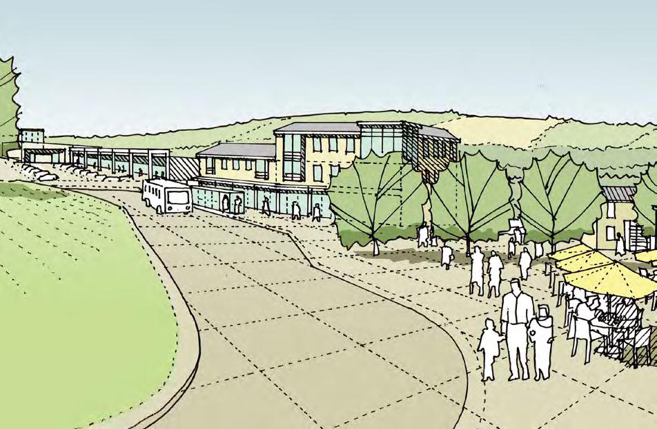
12 1. DEVELOPMENT OVERVIEW & VISION 1.1. Overview and Vision The vision for the application is to provide a vibrant mixture of uses that ensures the delivery and enhances the character of the consented Langarth masterplan including the new stadium. To achieve this vision the proposed development includes: A food store Comparison retail units Food and beverage outlets A day nursery Associated car parking and petrol filling station Housing and apartments Community/ sports building alongside provision for sports pitches A variety of public open spaces Improved connections and linkages Images: 1. Concept diagram showing the connection between the site and the Langarth masterplan. Opposite page: The location of the site within Truro and its connection to the Langarth masterplan Key Site Boundary Settlement Boundary Langarth Masterplan A Roads The scheme will be designed to encourage more sustainable lifestyle decisions including walking, cycling and the use of public transport. The strategy of providing a mix of uses for the entire masterplan will encourage a sustainable development that remains attractive to residents, visitors, businesses and the wider community. This range of uses will also ensure the continued viability, success and vibrancy of the new community. RETAIL Successful mixed-use development has a good level of synergy. It is more than the sum of its parts. By integrating retail accommodation and good quality public open space to the wider consented development at Langarth that includes the new stadium, a more comprehensive and sustainable overall masterplan will be achieved. Furthermore the extensive amount of housing at Langarth will benefit from a new district centre. The commercial and leisure content of the design will balance well with the other areas for the Langarth masterplan. This balance of uses has been established by working closely with commercial property developers who understand the property market and tenants demands. The mix of uses has also been tailored with wider urban design and landscape considerations including orientation, scale, topography and active frontages. Buildings will be laid out to reinforce the connectivity to the consented Langarth scheme and promote vibrancy and activity. Good urban design strategies will be adopted to ensure successful buildings and places are achieved. Activity A390 LEISURE & STADIUM 12

13 WEST LANGARTH LANGARTH THREEMILESTONE TRURO


14 1. DEVELOPMENT OVERVIEW & VISION Images: 1.1. Overview and Vision 1. The consented scheme for the stadium. Opposite page: Illustrative bird s eye view sketch of the proposal. The character of the scheme will change through the day and throughout the year. The buildings will be used in a variety of ways in different weather conditions as well as at night. This enabling application will ensure the realisation of the new stadium at the heart of the consented Langarth masterplan. This new stadium is a vital and intrinsic part of the overall masterplan. As the stadium is a key aspect of the masterplan, the connectivity, use and integration of further development must be carefully considered. This application has a variety of uses including the district centre and housing however one key aspect of the application is the public open space. The uses for the public open spaces and associated relationship to the stadium acts as a very strong connection between the consented masterplan and the application site. This public open space of this application echoes the uses in and around the stadium. There will be sport and leisure activities with the provision of sports facilities that can be used for the wider community. The connectivity of the new public open spaces to the stadium will be a key design driver that will promote more sustainable and active ways of life. The extension of the green routes that are provided in the consented Langarth masterplan will reinforce this connection. The following factors will be promoted to ensure a successful mixed use scheme is achieved. These include: A Distinctive Place: Creating an environment that has it s own sense of identity whilst retaining positive characteristics of the local environment. Making a place that people can understand and negotiate with ease. Permeability: Creating sustainable connections within the development and to the wider area. Sustainable Transport: Encouraging walking and cycling and making public transport widely available. Designed to reduce resource consumption and promote the use of environmentally friendly materials. Landscape Enhancement: Safeguarding and enhancing the existing landscape framework and mitigating the impact upon existing wildlife. Sustainable drainage designed to blend with the existing landscape features. The design proposals must embrace the vision for the development. Inox Group and Henry Boot Development s vision for the Langarth is: To create a high quality, well connected urban extension, which adopts a Green Infrastructure led approach and embraces sustainability at all levels, providing an exceptional place for people to live, work and play. The vision will be achieved by meeting the following aims: The creation of a sustainable environment for living with a mix of residential accommodation to reinforce a diverse and vibrant community. A sustainable development which responds to best practice and the criteria of the Code for Sustainable Homes and current Building Regulations to minimise energy use, sustainably manage water, responsibly source materials and manage waste and ecology. A place with a varied character that responds to the local vernacular and built context in a modern way to provide a distinctive sense of place. Use of the strong existing landscape framework including trees, Cornish Hedges and the stream corridor to form the basis for a Green Infrastructure led masterplan that shapes the morphology of the scheme and results in a scheme that responds to and integrates with the landscape context. A development which preserves and enhances biodiversity by retaining natural features on the site, reinforcing them by creating opportunities for new habitat areas. 1 14

15 PROPOSED PLAYING PITCHES PROPOSED DISTRICT CENTRE 1. DEVELOPMENT OVERVIEW & VISION STADIUM A390 15


.")
16 1. DEVELOPMENT OVERVIEW & VISION 1.2. Cornwall Design Guide 1.3. Development Principles Any new development on the site will be required to accord with the urban design objectives and advice set out in the new Cornwall Design Guide (adopted by the Council in Autumn 2012) and to encompass the attributes of sustainable communities including those relevant to crime prevention. This includes details in respect of layout, form and materials, street lighting, security and green energy measures. The general approach to design should contribute towards the creation of sustainable, safe, interesting, and attractive living environments with individual and distinctly recognisable places in accordance with Safer Places The Planning System and Crime Prevention (ODPM 2005). Its definition of Sustainable communities is those which succeed economically, socially and environmentally, and respect the needs of future generations. They must be well designed places where people feel safe and secure, where crime and disorder or the fear of crime does not undermine the quality of life or community cohesion. The development proposals will reflect current government guidance on creating high quality development and improving the design quality of the urban environment and in particular draw upon guidance within the following documents: National Planning Policy Framework (2012) By Design (2000) CABE Manual for Streets (2007) Manual for Streets 2 (2010) English Partnerships Car Parking - What Works Where (2006) Building for Life 12 (2012) The above documents set out objectives to create sustainable and welldesigned efficient development, planned to respond positively to its context and promote environmentally friendly activity patterns. To this end an opportunity exists to produce a unique proposal. The scheme must respect its setting and strive for quality in design of the built environment. Design of the public realm will be paramount, creating a sense of place that reinforces civic pride and promotes a community spirit. The principal points to be achieved in meeting these objectives are: 1. Identity: Creating an environment that has its own sense of identity whilst retaining positive characteristics of its local environment. 2. Legibility: Making a place that people can understand and negotiate with ease. 3. Permeability: Creating sustainable connections within the development and to the wider area. 4. Sustainable Transport: Encouraging walking and cycling and making public transport widely available to reduce social exclusion. 5. Energy Conservation: Settlement designed to reduce resource consumption and promote the use of environmentally friendly materials. 6. Landscape Enhancement: Safeguarding and enhancing the existing landscape framework and mitigating the impact upon existing wildlife. 7. Sustainable Drainage: Provision of SUDS features designed to blend in with the existing landscape features. 8. Green Infrastructure: Retention of landscape features and functions, retention and enhancement of ecological habitats, integration of access functions and SUDS. Applicants must demonstrate how the above principles have been addressed in the Reserved Matters Design Proposals. The sign of a good place to live by design Urban design in the planning system: towards better practice CORNWALL Cornwall Design Guide 12» 16


17 1. DEVELOPMENT OVERVIEW & VISION 17

18

19 2. Analysis X. Title


20 2. ANALYSIS 2.1. Truro History of the Area Truro began as a small settlement in the 12th century following the construction of a castle, within the grounds of which, the settlement originated (the castle is no longer evident). At the beginning of the14th century Truro was an important port with a flourishing fishing industry, it was also awarded stannary town status and was an important hub for tin and copper from local Cornish mines. Truro continued to prosper and by the 18th and 19th century, boosted by improved mining methods and higher prices for tin, the town soon became the place of choice for wealthy mine owners. Substantial, elegant townhouses were built, such as those along Lemon Street. Truro s importance increased further in the 19th century as an industrial centre and further major expansion came with the arrival of the railway in the 1860s with a direct line from London Paddington. In 1876 the cathedral was constructed and a year later Truro was granted city status. The start of the 20th century saw the decline of the mining industry; however Truro has remained prosperous and is recognized as being the civic and retail capital of the region, with a focus on public sector employment and tourism. 1 3 Images: 2 1. The centre of Truro 2. Truro Cathedral 3. Bird s eye view of Truro Opposite page: Location of Truro in relation to other cities in the UK 20

21 Birmingham 2. ANALYSIS Cardiff Bristol London Devon Southampton Exeter Cornwall Truro Plymouth 21

22 2. ANALYSIS 2.2. The Site and its Surrounding Key Site Boundary The site lies 6km to the west of the centre of Truro, 3km west of Royal Cornwall Hospital and Northwest of the Threemilestone area and Truro Park & Ride. The A390 runs west to east to the south of the site forming a major transport corridor into Truro. The approach to Truro along this corridor is characterised by some private properties, a number of smaller industrial and business units and a retail park closer to Threemilestone. Images: 1: Location of the site within Truro Opposite page: Location of the site in relation to the Langarth Masterplan Settlement Boundary Langarth Masterplan A Roads To the south east of the site on the other side of the A390 is the community of Threemilestone which largely consists of 20th century housing with a selection of amenities. This is the westernmost settlement in a string of towns/villages along the A390 including Gloweth and Highertown that connect to Truro. THREEMILESTONE Shortlanesend To the north of the site, the settlement pattern is more scattered and rural both in character and building style with a number of isolated farmhouses and hamlets. WEST LANGARTH LANGARTH TRURO In close proximity to the site, being surrounded on all sides except their north are the small clusters of buildings at Langarth and West Langarth of various rural building styles. Approximately 3km north west of the site is the village of Shortlanesend on the B3284, a settlement consisting of largely late 20th century housing. Further to the southeast lies the former mining villages of Carnon Downs and Playing Place now both expanded with later 20th century residential areas. To the south west of the site are Chacewater, St. Day and Carharrack, all of which have 19th century housing typical of such mining villages. Chacewater St. Day and Carharrack 1 Playing Place and Carnon Downs 22

23 2. ANALYSIS WEST LANGARTH LANGARTH THREEMILESTONE 23

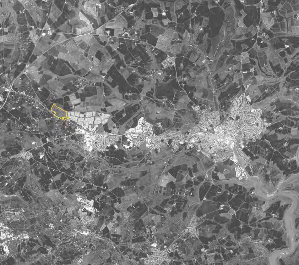
24 2. ANALYSIS 2.3. Location The majority of the site s perimeter and internal boundaries (with the exception of much of the northern boundary) consist of Cornish hedges. The vegetation on the Cornish hedges varies between sections, some having low scrub and grasses no more than 1m above the earth and stone construction while some have shrubs and broadleaved trees up to approximately 20m in height. A narrow, shallow stream runs beyond the northern boundary of the site, eastwards along the wooded valley bottom. Drainage ditches are found on the site running along the northern edges of the fields adjacent to the stream and along the northern part of the far eastern boundary. The application site is hectares. Images: 1: Location of the site in relation to the Langarth masterplan Opposite page: Bird s eye view of the site, with Truro in the background Key Site Boundary Settlement Boundary Langarth Masterplan WEST LANGARTH LANGARTH THREEMILESTONE 1 24

25 LANGARTH TRURO THREEMILESTONE A ANALYSIS 25


26 2. ANALYSIS 2.4. The Site Site Photographs 1. There is a consistent language along the A390 at the southern edge of the site. There are wide verges and clear visibility in both directions. The A390 runs parallel to the site and is generally straight and level in both directions away from the site. 2. The site falls away from the A390 as fields towards the north. There are some existing hedgerows at the edges of the site. The site is visible from the A The topography and changes in level across the site are indicated. 4. Existing vehicular access to the site. 5. View from the site towards the development at Royal Cornwall Hospital and consented Langarth site in foreground

27 2. ANALYSIS


28 2. ANALYSIS 2.5. Truro s Location Key Site Boundary Pattern of Development and Growth Truro is situated in a distinctive bowl landform, which forms a strong physical and visual boundary to the city s setting. The eastern, south western and north western fringes of the city have expanded up to this boundary, resulting in limited potential to expand the city further within its natural setting. Much of the surrounding landscape, beyond the natural city boundary, is of high quality with several areas being designated areas of great landscape importance, making the settling of the city particular sensitive to landscape change. Truro has grown and developed around the historic city centre in a nucleated fashion along the bowl valley slopes. With opportunities for in-filling being limited, the late 18th century saw a period of growth away from the centre, with Lemon Street forming an upwards linear expansion. Following the arrival of the railway, terrace houses followed the rail line up the hillsides above the central core. Late Victorian and Edwardian villas spread away from the medieval centre, following main routes, along ridge lines. As Truro has continued to grow, the historic pattern of development, away from the centre, has continued and a number of settlements have been incorporated, creating suburbs. These include Kenwyn and Moresk to the north, Trelander to the east, Newham to the south and Highertown, Treliske and Gloweth to the west. 1 2 Settlement Boundary Langarth Masterplan Landscape Features Water Courses Topography Contours 3 Images: 1. Truro Landscape Strategy, 2008: Diagram showing the hill and the bowl setting of Truro, which forms the structure of the city and limits its expansion. 2. Truro Landscape Strategy, 2008 : Diagram showing the structural edges provided by the edge of the bowl and the edge of the plateau. Structural paths provided by the river valleys. 3. Truro Landscape Strategy, 2008 : Placemaking: Integration of the landscape framework and the basic urban design and transport concepts to perpetuate legibility and local identity. Opposite page: Topography of Truro 28

29 2. ANALYSIS 29
30 2. ANALYSIS 2.6. Flooding The Langarth Stream, a tributary to the River Kenwyn and designated as a Secondary River, is located to the east of the site at a lower elevation. To the north of the site a tributary to the Langarth Stream runs generally in a west to east direction also at a lower elevation. The watercourse is designated as a tertiary river and six contributory sources are identified within a 500 m radius of the approximate site centre. It is likely that these sources are springs / issues associated with the geology of the area. Key Site Boundary Langarth Masterplan Flood Zone Watercourse A- Roads A review of the publically available Environment Agency Maps shows that the application site is within Flood Zone 1 and that no historic flood events have been identified or recorded within the vicinity of the proposed development site. Images: 1. Plan showing watercourses in Truro Opposite page: Flood zone plan The topography of the area is such that A390 forms the watershed of two catchments. The site is located adjacent to the watershed and therefore is unlikely to experience any major overland flow from adjacent land unless there is a failure of the drainage associated with the highway corridor. The published geological conditions for the development area indicate that the site is underlain by the Porthtowan Formation of the Gramscatho Group comprising mudstone and sandstone. Trial pits and soakage testing, undertaken within the adjacent Langarth site, indicates that the Porthowan Formation has weathered to a silty gravel and that the permeability of the weathered formation is suitable for infiltration systems. The proposed development will integrate Sustainable Drainage Systems into the green infrastructure to control and treat surface water runoff. The commercial development and highway infrastructure will drain via positive drainage to storage basins located at the northern aspect of the site where the outfall to the adjacent watercourse will be restricted to the 1 in 1 year Greenfield runoff rate for the undeveloped site. The residential areas will drain to private infiltration systems comprising permeable paving and traditional soakaways. All systems will be sized to accommodate the 1 in 100 year plus 30 % climate change rainfall event. 1 30

31 2. ANALYSIS 31

32 2. ANALYSIS 2.7. Movement The main spine road, the A390, provides access to Truro, and connects to the A30, linking Truro to Exeter to the North and Penzance to the South. The A390 acts as a spine road due to the landscape constraints discussed in the previous chapter. This spine road and the topographic constraints limits the expansion of Truro, allowing expansion to continue to the West along this spine road. The railway line runs through Truro with the Truro railway station being located in the centre of city. Truro lies on the Cornish Main Line between Penzance and Plymouth served by First Great Western and Cross County trains. Truro is also the start to the Maritime Line to Falmouth Docks. There is a park and ride park to the West of Truro, near the proposed site, and can be accessed from the Threemilestone roundabout. This western Park & Ride provides a major opportunity to promote sustainable travel into the city as this transport hub is already provided near the site. Key Site Boundary Settlement Boundary Langarth Masterplan Access A- Road B-Road Railway Station Railway Line Park and Ride Park The site is located 6-kilometres west of the centre of Truro and 3-kilometres west of the Royal Cornwall Hospital, on the northern side of the A390. The Strategic Road Network (SRN) is located some 2-kilometres to the west, via the A30-Chiverton Cross interchange. 1 Park and Ride Line 2 Images: 1. The A390 as a spine road 2. West Park and Ride map Opposite page: Major transport routes and locations in Truro 32

33 2. ANALYSIS WEST LANGARTH LANGARTH THREEMILESTONE TRURO 33
34 2. ANALYSIS 2.8. Access into Truro 800m walking distance = 10 minutes Key Site Boundary Due to the way Truro has expanded, the city centre, located furthest away from the A30, is accessed via the A390 from the West. To drive into the centre from the proposed site would take around 10 minutes. However, Truro is also well served by bus links as well as the park and ride which is located just under a mile from the proposed site. 400m walking distance = 5 minutes 800m walking distance = 10 minutes Settlement Boundary Langarth Masterplan There will be good connectivity between the proposed site and the Langarth site. Walking distances between the proposed district centre and the stadium will be just over 10 minutes. 400m walking distance = 5 minutes Roads A- Road Driving Time at Noon on a Weekday from site PARK & RIDE 1 Proposed bus stop hub Consented stadium Images: 1. Diagram showing walking distances between the proposed site and the Langarth masterplan Opposite page: Driving times from the site 34

35 2. ANALYSIS 35
Chapter 2: OUTLINE PLANNING APPLICATION PROPOSALS. A New Garden Neighbourhood Matford Barton 17
 Chapter 2: OUTLINE PLANNING APPLICATION PROPOSALS A New Garden Neighbourhood Matford Barton 17 2.1. SUMMARY AND STATUS OF THE PROPOSALS 2.1.1. The parameter plans and associated wording in this chapter
Newcourt Masterplan. November Exeter Local Development Framework
 Newcourt Masterplan November 2010 Exeter Local Development Framework Background The Exeter Core Strategy Proposed Submission sets out the vision, objectives and strategy for the development of Exeter up
8.0 Design and Form of Development 43/
 42/ 8.0 Design and Form of Development 43/ Rothwells Farm, Golborne/ Development Statement Figure 7. Site Constraints Key 44/ Site Boundary 360 Bus Route/Stops Existing Trees Underground Water Pipe Sensitive
WELCOME GYPSY LANE. Wider Site Location plan. Proposals for the development of LAND OFF FOXLYDIATE LANE WEBHEATH. Proposals for the development of
 WELCOME The developers are preparing an outline planning application for a residential led development and need the community s views in order to develop the proposals further WHAT IS PROPOSED? A high
Page 1 of 19 URBAN DESIGN FRAMEWORK FOR BOLTON STREET WATERFORD
 Page 1 of 19 URBAN DESIGN FRAMEWORK FOR BOLTON STREET WATERFORD 1.0 Introduction: The relocation of the City Council stores and depot from Bolton Street creates an exciting opportunity for development
Schedule of Planning Applications Committee Date: 23 May Reference: 06/17/0726/F Parish: Hemsby Officer: Mr J Beck Expiry Date:
 Schedule of Planning Applications Committee Date: 23 May 2018 Reference: 06/17/0726/F Parish: Hemsby Officer: Mr J Beck Expiry Date: 22-05-2018 Applicant: Proposal: Site: Mr Gillett Change of use to the
Colchester Northern Gateway Master Plan Vision Review Draft. July 2016
 Colchester Northern Gateway Master Plan Vision Review Draft July 2016 Contents Introduction 4 Context 8 Purpose of the Report 8 Strategic Position 9 Overview of the Process 11 2012 Master Plan Vision 12
Public Consultation. Land at Monks Farm, North Grove. Welcome
 Welcome Welcome to our public exhibition for development on Land at Monks Farm, orth Grove. Gallagher Estates and Gleeson Strategic Land are preparing an outline planning application for new homes, open
Rochford District Council Allocations Development Plan Document: Discussion and Consultation Document Sustainability Appraisal
 Option SWH1 Balanced Communities Option SWH1 1 To ensure the delivery of high quality sustainable communities where people want to live and work Will it ensure the phasing of infrastructure, including
Welcome to our public exhibition
 About our development Welcome to our public exhibition This exhibition gives you the chance to view and comment on our proposals for a new residential development of 165 high-quality homes, along with
Kibworth Harcourt. Introduction. Introduction
 Introduction Introduction Welcome to this public exhibition on the proposals for the delivery of new homes on land at The Kibworths. The purpose of today s exhibition is to give you the opportunity to
Statement of Community Involvement LAND OFF SOUTHDOWN ROAD HORNDEAN, HAMPSHIRE
 LAND OFF SOUTHDOWN ROAD HORNDEAN, HAMPSHIRE CONTENTS Page 1. Introduction 3 2. Pre-application Discussions 4 3. The Consultation Process 5 4. Consultation Feedback 7 5. Responses to Consultation Feedback
Welcome. Site/11/04. Site/11/03. Proposed Site. 11,400 new homes needed in east Cambs
 Welcome Welcome to our consultation on our proposals for new homes on land north east of Soham Road, Fordham. Members of the project team are available to answer any questions you have and listen to feedback.
A. The sites in Table 16 below, as identified on the Policies Map, are allocated for retail-led development:
 SWDP 44: Worcester City Centre A. The sites in Table 16 below, as identified on the Policies Map, are allocated for retail-led development: Table 16: Sites Allocated for Retail-Led Development Policy Reference
HARDWICK GREEN, King s Lynn. Welcome to our Exhibition. What are your views? Introduction to the site and proposals. About us
 HARDWICK GREE, King s Lynn Welcome to our Exhibition Welcome to our exhibition, which is being held to provide you with the opportunity to understand and comment upon our proposals for new residential
5. Bankside and The Borough 5.1. Bankside and The Borough Area Vision
 5. 5.1. Area Vision 5.1.1. are: A globally significant central London business district which is home to international business headquarters; At the heart of the commercial and cultural life of the capital
University Park, Worcester Non Technical Summary December 2011
 University Park, Worcester Non Technical Summary December 2011 Introduction UW Wrenbridge LLP, a Joint Venture Company of the University of Worcester and Wrenbridge Land Ltd (the Applicants ) intend to
Subdivision Design Criteria. Penihana North GUIDELINES TO THE RULES
 Created September 2013 Penihana North Subdivision Design Criteria GUIDELINES TO THE RULES This part of the Plan sets out the design criteria for subdivision in Penihana North. The criteria will be considered
COURTHOUSE CAMPUS BARNSLEY Executive Summary March 2010
 COURTHOUSE CAMPUS BARNSLEY Executive Summary March 2010 Estell Warren Cartwright Pickard Buro Happold King Sturge BWA Barnsley Metropolitan Borough Council introduction Courthouse Campus is the last major
Hampton Park North Littlehampton West Sussex
 North Littlehampton West Sussex SUMMARY Summary An opportunity to create a new community in West Sussex on the northern outskirts of Littlehampton with outstanding views across open countryside towards
3.1 The hybrid planning application proposes the following description of development:
 CHAPTER 3: PROPOSED DEVELOPMENT 3.1 The hybrid planning application proposes the following description of development: Hybrid (part-outline/part-full) planning application for a single composite development
WELCOME. Land North of STEVENAGE. We would like to thank you for attending our public exhibition today.
 WELCOME We would like to thank you for attending our public exhibition today. The purpose of this event is to share our proposals and hear your thoughts on our ideas. Members of the project team are on
INTRODUCTION. Land south of Bishopswood Lane, Tadley
 0 INTRODUCTION THE SITE Introduction Gladman Developments Ltd. has successfully invested in communities throughout the UK over the past 0 years, developing high quality and sustainable residential, commercial
Planning and Sustainability Statement
 Land adjacent to Manor Farm, Catterick Village Pallett Hill Sand and Gravel Co Ltd Proposed 10 new dwellings, (6 No market dwellings and 4 No affordable dwellings) with access, associated car parking and
2040 LUP is a part of the Comprehensive Plan and carries the same legal authority. Economic Challenges
 1.1. Guiding Anchorage s Growth Where will new residents settle over the next two decades? Where will people work, shop, and play? Will there be enough room to grow? How will Anchorage look? Will growth
LAND EAST OF HORNDEAN. 1. Welcome. Morrisons supermarket. Keydell Nurseries A3(M)
") 1. Welcome Bloor Homes welcomes you to today s Public Exhibition relating to development proposals for Land to the East of Horndean. Idsworth Close Rowlands Castle Road Roa d Dell Piece East J2 Pyle Farm
1. Welcome Bloor Homes welcomes you to today s Public Exhibition relating to development proposals for Land to the East of Horndean. Idsworth Close Rowlands Castle Road Roa d Dell Piece East J2 Pyle Farm
elbridge Core Strategy
 C elbridge Core Strategy Celbridge is designated as a Moderate Growth Town in the RPGs. The County Development Plan reinforces this designation in its settlement strategy. Moderate Growth Towns within
INTRODUCTION NORTH HEYBRIDGE GARDEN SUBURB
 INTRODUCTION This event is being hosted by the promoters of the proposed North Heybridge Garden Suburb who are working with Maldon District Council and other key stakeholders on the preparation of a comprehensive
Welcome to our Public Consultation
 About our development This exhibition gives you the chance to view and comment on our emerging plans for a proposed residential development located on land to the West of Alwyn Road, Rugby. Welcome to
The Fairfield Partnership Vision for North-East Elsenham
 The Fairfield Partnership Vision for North-East Elsenham August 2009 Frequently Asked Questions Who is The Fairfield Partnership? The Fairfield Partnership is a joint venture between Marchfield Developments
DESIGN AND ACCESS STATEMENT NEW TALYBONT HALLS, CARDIFF UNIVERSITY JULY 2018
 DESIGN AND ACCESS STATEMENT NEW TALYBONT HALLS, CARDIFF UNIVERSITY JULY 2018 1 FILE NTHCU-STL-XX-XX-RP-A-9075-RP013 PROJECT New Talybont Halls, Cardiff University CLIENT Cardiff University STRIDE TREGLOWN
South Whitehaven, Cumbria EIA
 South Whitehaven, Cumbria EIA Environmental Statement - Non Technical Summary June 2013 in association with 1. Introduction Story Homes is applying to Copeland Borough Council (CBC) for a new residential
Response to the London Bridge Area Vision and Site Allocations within the New Southwark Plan
 1 Melior Place London SE1 3SZ 020 7407 4701 teamlondonbridge.co.uk info@teamlondonbridge.co.uk 28 April 2017 Response to the London Bridge Area Vision and Site Allocations within the New Southwark Plan
WELCOME. Welcome and thank you for visiting today.
 WELCOME Welcome and thank you for visiting today. Bellway Homes Ltd (Yorkshire) are preparing a reserved matters planning application for a residential development of 293 homes at land North of Yew Tree
The journey so far. The new masterplan for Dargavel Village
 The journey so far Our vision for Dargavel Village began over ten years ago when the original masterplan for transforming the former Royal Ordnance Factory site into a thriving community was established.
WELCOME. North East Haverhill. The Planning Process
 WELCOME North East The site to the North East of, known as Great Wilsey Park, is identified by St Edmundsbury Borough Council in its Core Strategy as capable of delivering a Sustainable Urban Extension.
Welcome to our public exhibition
 About Our Scheme Welcome to our public exhibition This exhibition gives you the chance to view and comment upon our emerging proposals for a new residential development of 68 new homes on the site of the
DESIGN & ACCESS STATEMENT
 DESIGN & ACCESS STATEMENT January 2016 Contents Introduction section 1 Section 1 - Introduction Section 2 - Assessment Section 3 - Involvement Section 4 - Evaluation Section 5 - Design Section 6 - Layout
Neighbourhood Planning Local Green Spaces
 Neighbourhood Planning Local Green Spaces Introduction... 2 1. Why green space is important... 4 2. Neighbourhood plans and green space... 6 3. Evidence... 8 Statutory designations... 9 Green space audit...
Tāhuhu whakaruruhau ā-taone The sheltering ridge pole
 B2. Tāhuhu whakaruruhau ā-taone - Urban growth and form B2.1. Issues Tāhuhu whakaruruhau ā-taone The sheltering ridge pole Auckland s growing population increases demand for housing, employment, business,
Story Homes. Land at Thirsk Road, Kirklevington. An Introduction to Story Homes. Our Foundations. Commitment to Consultation.
 Story Homes An Introduction to Story Homes Founded by Fred Story in 1987, Story Homes has a long and successful reputation of building high quality and high specification homes. The family owned business
Memorial Business Park Site. Proposed Future Development. Design guidelines. August
 Memorial Business Park Site Proposed Future Development Design guidelines August 2014 www.designenvironment.co.nz 0064 3 358 3040 Contents 1.0 Background 1.1 Introduction 3 1.2 Objectives 4 2.0 Context
Land East of Cromwell Lane
 Land East of Cromwell Lane VISION DOCUMENT AUGUST 2016 The proposals for Land East of Cromwell Lane will be defined by existing landscape features, ensuring that the development offers a quality place
DESIGN & ACCESS STATEMENT
 DESIGN & ACCESS STATEMENT Land to the South East of the A495, Bronington Erection of 31 Dwellings (27 dwellings and 4 bungalows including 4 Affordable Dwellings), Realignment and Improvements to A495 (including
PDP DESIGN & ACCESS STATEMENT
 PDP The Planning & Design Partnership Planning.. Architecture.. Interiors.. Landscape The Chicory Barn Studio, The Old Brickyards, Moor Lane, Stamford Bridge York, The East Riding Of Yorkshire, YO41 1HU.
Application Guide. Should you have any questions on the Outline Application please contact:
 Application Guide Application Guide This guide describes the structure of the Outline Application, explains the different documents that have been submitted with it and identifies what will happen next.
Rotherhithe Rotherhithe Area Vision Map
 Area Vision Map CWAAP1 Improved pedestrian and cycle links to the wider area Improved link from town centre to River Thames and docks CWAAP2 Brunel Museum NSP79 CWAAP3 Proposed Thames Crossing Station
Truro & Threemilestone Draft Final Report November 2008
 65 V. Masterplan The city centre has been identified as the priority location for new development, which must reinforce its historic character, its retail, civic and cultural role. Particular focus is
Residential Development at Menehay Farm, Bickland Water Road, Falmouth Design and Access Statement
 Residential Development at Menehay Farm, Bickland Water Road, Falmouth Design and Access Statement Galliford Try STRIDE TREGLOWN JOB NO. PREPARED BY CHECKED BY DATE REVISION REVISION NO. 150220 Coral Ducroq
Design Guidance. Introduction, Approach and Design Principles. Mauritius. November Ministry of Housing and Lands. .. a
 sig evelo r D Mauritius s. Utilities.. Individu a s. er itects.to ls chpers.po e Public. T. h rban D Sc U e me Promot e h ners. A Design Guidance o.h Planne rs n w iticians r l useholde National Development
vision & process willowburn, tarves community engagement 04/18
 vision & process Historic Conservation area Scotia intend to create a high quality residential development based upon best practice urban design principles. This will include a contemporary reinterpretation
The Proposed Auckland Unitary Plan (notified 30 September 2013)
") 3 Business zones Introduction There are 10 business zones in the Unitary Plan: City Centre Metropolitan Centre Town Centre Local Centre Neighbourhood Centre Mixed Use General Business Business Park Light
3 Business zones Introduction There are 10 business zones in the Unitary Plan: City Centre Metropolitan Centre Town Centre Local Centre Neighbourhood Centre Mixed Use General Business Business Park Light
WELCOME TO THE NEW WILTON PARK
 WELCOME TO THE NEW WILTON PARK VISION HISTORY OF WILTON PARK TOWARDS A PLANNING APPLICATION Our objective is to create a truly outstanding environment at Wilton Park. At the heart of our proposals is a
Welcome - Halse Yard, Honiton
 Welcome - Welcome to this consultation regarding potential new Starter Homes on the Halse Farm Machinery site at West End, Honiton. The purpose of this exhibition is to provide the community with an early
PHASE III: Reserved Matters Submission
 Statement of Compliance with the outline approval for the proposed residential development of land at: BURGES LANE, WIVELISCOMBE PHASE III: Reserved Matters Submission Foreword Contents: This Statement
Land at Rampton Road. Cottenham
 Land at Rampton Road Cottenham Introduction TEP is preparing an outline planning application for 54 dwellings on 6.9 hectares of land adjacent to Rampton Road, Cottenham on behalf of the owners Cambridgeshire
WELCOME. Olney Road, Lavendon INTRODUCTION. The Site. The Application. The Need for Housing. A Sustainable Location LAVENDON TURVEY OLNEY ROAD
 0 WELCOME INTRODUCTION Gladman Developments Ltd have successfully invested in communities throughout the UK over the past 0 years, developing high quality and sustainable residential, commercial and industrial
The West Vaughan Employment Area Secondary Plan Policies
 Part 2: The West Vaughan Employment Area Secondary Plan Policies 2.1 General Policies It is the policy of Council: 2.1.1. That the West Vaughan Employment Area (the WVEA), identified on Schedule 1, will
Longbridge Town Centre Phase 2 Planning Application
 Longbridge Town Centre Phase 2 Planning Application Non-Technical Summary of the Environmental Statement December 2013 Introduction A full application for Planning Permission has been submitted to Birmingham
CENTRAL BEDFORDSHIRE COMMITTED TO WORKING TOGETHER WITH LOCAL COMMUNITIES
 WELCOME Thank you for coming to our consultation event to find out more about our emerging proposals for Hayfield Park, a residential development jointly promoted by the Hayfield Consortium: Martin Grant
Welcome to our exhibition
 Welcome to our exhibition housing development A46 Wildmoor Alcester Road Canal Quarter A422 Town Centre housing development Warwickshire-based IM Properties, one of the UK s largest privately owned property
QUEENSTOWN LAKES DISTRICT COUNCIL SUBDIVISION DESIGN GUIDELINES
 Attachment C: Draft QLDC Subdivision Design Guidelines QUEENSTOWN LAKES DISTRICT COUNCIL DESIGN GUIDELINES A DESIGN GUIDE FOR AND DEVELOPMENT IN THE URBAN ZONES QUEENSTOWN OFFICE 10 Gorge Road Queenstown
Former North Works, Lickey Road, Longbridge, Birmingham
 Committee Date: 14/11/2013 Application Number: 2013/06431/PA Accepted: 27/08/2013 Application Type: Full Planning Target Date: 26/11/2013 Ward: Longbridge Former North Works, Lickey Road, Longbridge, Birmingham
STATEMENT OF OBJECTION TO THE PROPOSED DEVELOPMENT OF LAND AT CHURCH CLIFF DRIVE FILEY
 STATEMENT OF OBJECTION TO THE PROPOSED DEVELOPMENT OF LAND AT CHURCH CLIFF DRIVE FILEY You will be aware that Scarborough borough council have adopted a new local plan that includes land at Church Cliff
Application and Proposals. Part 211
 Application and Proposals Part 211 Site Location and Context The application site comprises two distinct land parcels totalling some 135 hectares. The site is bisected eastwest by Churchlands Development.
Frequently Asked Questions
 1. Where is Aylesbury Woodlands? Frequently Asked Questions Aylesbury Woodlands lies to the east of Aylesbury. It is bounded to the south by the A41. To the north is the Aylesbury Arm of the Grand Union
Droitwich Spa 6. Reasoned Justification
 87 Droitwich Spa 6 Reasoned Justification 6.1 Droitwich Spa is identified in the settlement hierarchy (Policy SWDP1) as a main town being the largest settlement in Wychavon District with an estimated population
2.0 Strategic Context 4
 2.0 Strategic Context 4 2.1 The Area Action Plan is a non-statutory plan, which forms a corporate policy document, expressing particular issues and areas of concern while also providing a vision for the
I615. Westgate Precinct
 I615. Westgate Precinct I615.1. Precinct Description The Westgate Precinct is located approximately 18km west of the Auckland city centre. There are seven Sub-precincts in the Westgate Precinct: Sub-precinct
4 RESIDENTIAL ZONE. 4.1 Background
 4 RESIDENTIAL ZONE 4.1 Background The residential areas within the City are characterised by mainly lowrise dwellings sited on individual allotments. Past architectural styles, settlement patterns and
16. Peckham Peckham Area Vision
 16. 16.1. Area Vision 16.1.1. is: A lively town centre providing a range of daytime and night time activities on Rye Lane including a Library, a Leisure Centre and many independent retailers which specialise
LAND AT WEST YELLAND. Environmental Statement Non-Technical Summary Welbeck Strategic Land LLP
 LAND AT WEST YELLAND Environmental Statement Non-Technical Summary Welbeck Strategic Land LLP May 2014 Quality Management Issue/revision Issue 1 Revision 1 Revision 2 Revision 3 Remarks Draft FINAL Date
Carton Avenue Action Area Plan Maynooth
 Carton Avenue Action Area Plan Maynooth Kildare County Council JULY 2006 (AAP) Table of Contents Section 1. Introduction...3 Statement of Strategy...3 Location of the Lands...3 Context in the Town Development
Revised draft District Plan for Council
 Revised draft District Plan for Council June 2012 1 Chapter 1: Background to the revised draft District Plan 1.1 This revised draft District Plan has been written in the context of the Localism Act and
Welcome to our exhibition
 Welcome to our exhibition The Homes & Communities Agency (HCA) welcomes you to this public exhibition explaining our proposals for the redevelopment of the former Lea Castle Hospital site. About the Homes
Toronto Complete Streets Guidelines
 Toronto Complete Streets Guidelines 108 110 7.1 Green Infrastructure Design Principles 112 7.2 Context-Sensitive Green Streets 114 7.3 Key Green Street Elements Green infrastructure refers to natural and
Appendix 1 Structure plan guidelines
 Appendix 1 Structure plan guidelines This appendix forms part of the regional policy statement [rps]. 1.1. Introduction Structure plans are an important method for establishing the pattern of land use
BLETCHLEY PARK AREA - DEVELOPMENT FRAMEWORK
 ANNEX A To Item 9 REVISED TEXT: additions shown bold and underlined, deletions in (brackets and in italics). BLETCHLEY PARK AREA - DEVELOPMENT FRAMEWORK This framework sets out the key objectives and requirements
9 Pershore. Introduction. Pershore Abbey
 118 Introduction 9.1 The historic town of Pershore lies on the River Avon and has a population of 7,000 (2009 Mid-Term Population Estimates). The main areas of the town are centred on the Abbey, the bustling
South Worcestershire Development Plan. South Worcestershire Design Guide Supplementary Planning Document
 South Worcestershire Development Plan South Worcestershire Design Guide Supplementary Planning Document Statement of Consultation: Early Engagement Scoping Paper February 2017 1. Introduction 1.1 This
Derry Green Corporate Business Park
 Town of Milton Derry Green Corporate Business Park Urban Design Guidelines BMI/Pace - June 2010 Draft 3 Prepared by: Brook McIlroy Planning + Urban Design / Pace Architects Suite 300-51 Camden Street Toronto,
Plan Modification to Chapter B2 of the Auckland Unitary Plan(AUP) Operative in part (15 November 2016)
 Operative in part (15 November 2016)") UNITARY PLAN UPDATE REQUEST MEMORANDUM TO FROM Phill Reid Linley Wilkinson DATE 25 September 2018 SUBJECT Plan Modification to Chapter B2 of the Auckland Unitary Plan(AUP) Operative in part (15 November
UNITARY PLAN UPDATE REQUEST MEMORANDUM TO FROM Phill Reid Linley Wilkinson DATE 25 September 2018 SUBJECT Plan Modification to Chapter B2 of the Auckland Unitary Plan(AUP) Operative in part (15 November
REMARKABLES PARK ZONE
 .10 Remarkables Park Zone.10.1 Resources, Activities and Values The Remarkables Park Area comprises approximately 150 hectares of perimeter urban land in the vicinity of Frankton and occupies a strategic
NON-TECHNICAL SUMMARY
 Proposed Sand and Gravel Extraction and Associated Processing Operations with Restoration to a Mixture of Agriculture and Nature Conservation including Areas of Shallow Water at Hedgeley, Northumberland
A VISION FOR BLAIRGOWRIE
 Welcome to the Westpark Partnership and Lidl UK GmbH Community Presentation. The purpose of this presentation is for you to view and comment upon the revised and updated proposals for the allocated development
INTRODUCTION. Land off Main Road, Great Leighs. Introduction
 01 INTRODUCTION Introduction Gladman Developments Ltd have successfully invested in communities throughout the UK over the past 20 years, developing high quality and sustainable residential scheme. We
Derry City and Strabane District Council Planning Committee Report. Amended layout from approval A/2004/0462/F with reduction from 166 units
 Derry City and Strabane District Council Planning Committee Report COMMITTEE DATE: 1 st February 2017 APPLICATION No: APPLICATION TYPE: PROPOSAL: LOCATION: APPLICANT: AGENT: Full Planning application Amended
SUSTAINABLE MANAGEMENT
 . Sustainable Management.1 The Concept of Sustainable Management The concept of sustainable management recognises there are limits to the use of natural and physical resources and there is a need to balance
BRIDGE OF DON MASTERPLAN & PLANNING SUMMARY
 BRIDGE OF DON MASTERPLAN & PLANNING SUMMARY SITE LOCATION The site of the existing AECC lies in an area of predominately residential and business use in Bridge of Don and extends approximately 50 acres.
HS2 Interchange Station Design
 Working on behalf of HS2 Interchange Station Design October 2018 www.hs2.org.uk 1 Interchange Station, Solihull Introduction In February 2018, HS2 Ltd appointed Arup to take forward the design of Interchange
PROPOSED URBAN STRUCTURE
 CHAPTER 3 PROPOSED URBAN STRUCTURE PLANNING PARTNERS: CENTURY CITY URBAN DESIGN FRAMEWORK October 2005 13 THE PROPOSED URBAN STRUCTURE The urban design rationale outlined in the previous chapter provides
BREEDON NORTHERN LIMITED
 Non Technical Summary CONTENTS 1 INTRODUCTION... 1 2 SITE DESCRIPTION... 1 3 DESCRIPTION OF THE DEVELOPMENT... 6 4 NEED FOR THE DEVELOPMENT... 8 5 KEY ISSUES CONSIDERED IN THE ENVIRONMENTAL IMPACT ASSESSMENT...
Peckham Peckham Area Vision Map
 Area Vision Map PNAAP13 PNAAP8 Sumner Road Surrey Canal Walk Bird in Bush Park Key: NSP Site Allocations PNAAP Allocations Greenspace Low Line Cycle Network Primary Shopping Areas Square Surrey Canal Walk
APPENDIX K WINDSOR OFFICIAL PLAN
 CEAA ENVIRONMENTAL ENVIRONMENTAL IMPACT ASSESSMENT AMBASSADOR BRIDGE ENHANCEMENT PROJECT Replacement Span and Plaza Expansion APPENDIX K WINDSOR OFFICIAL PLAN Avalon Consulting Professionals of Ontario,
Carterton Construction Ltd is bringing forward plans for up to 85 new family homes and extra care facilities on land east of Burford.
 Welcome Carterton Construction Ltd is bringing forward plans for up to 85 new family homes and extra care facilities on land east of. We are at the early stages of designing our proposals and have a number
Site ref: AS06 Site Name or Address: Murreys Court, Agates Lane
 Site ref: AS06 Site Name or Address: Murreys Court, Agates Lane Proposed Land Use: Total Site Area (Ha): Housing 1.85 Ha Description: It is understood that the owner has no plans to dispose of the site
Alder View. Introduction. Alder View. Harwell. The Vision. The Team. Taylor Wimpey
 Introduction Welcome to the public exhibition for, a development by Taylor Wimpey on the land south of Grove Road,. This exhibition will provide an overview of the development proposals for the site and
Introduction. Welcome to this consultation regarding the draft redevelopment proposals for the former CeramTec factory on Sidmouth Road, Colyton.
 Introduction Welcome to this consultation regarding the draft redevelopment proposals for the former CeramTec factory on Sidmouth Road, Colyton. We are currently considering options for the mixed-use redevelopment
Land at BROOK STREET PROPERTIES TENCREEK FARM, LISKEARD. Environmental Statement: Non-Technical Summary
 BROOK STREET PROPERTIES TENCREEK FARM, LISKEARD Land at Environmental Statement: Non-Technical Summary Introduction Brook Street Properties is applying to Cornwall Council for outline planning permission
LAND SECURITIES REDEVELOPMENT OF NEWNHAM COURT SHOPPING VILLAGE, MAIDSTONE
 LAND SECURITIES REDEVELOPMENT OF NEWNHAM COURT SHOPPING VILLAGE, MAIDSTONE Land at Environmental Statement: Non-Technical Summary Introduction Land Securities plc is applying to Maidstone Borough Council