SESSION #1: PLANNING TACTICS
|
|
|
- Rhoda Theresa Craig
- 5 years ago
- Views:
Transcription

1 CITY OF COMPREHENSIVE PLAN COMMITTEE AGENDA APRIL 12, :30 PM CITY HALL SESSION #1: ATTACHMENT 1: INTERVIEW RESULTS ATTACHMENT 2: SECTION FROM 2030 COMP PLAN
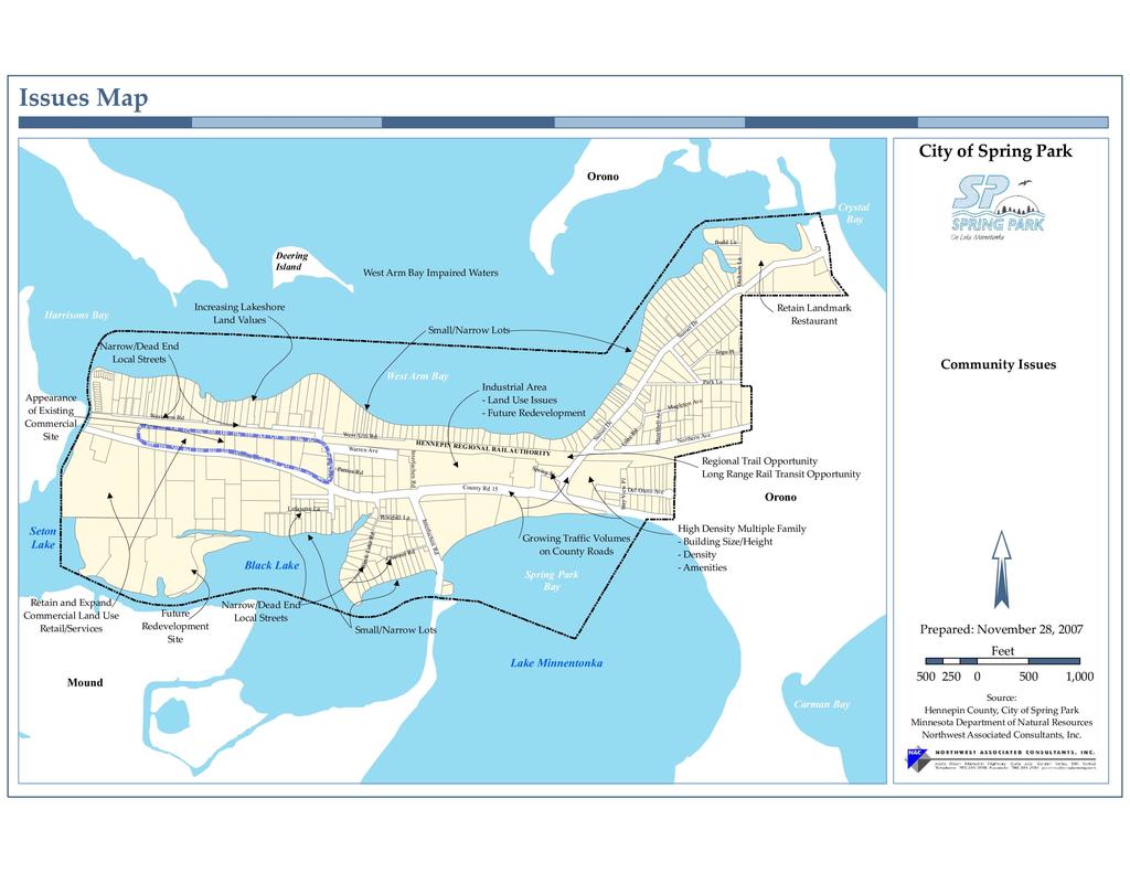
2 TACTICS INTERVIEW ISSUES Community Identity 1. Need to clean up enforcement 2. Redevelop bad sites 3. Community gatherings Events National Night Out Inter-community events 4. Keep Post Office 5. More activities for children and young adults 6. Improve street conditions Protect Single Family Neighborhoods 1. Rental ordinance inspections and repairs Rentals in single family neighborhoods Party houses Low end rentals have created nuisances and public safety issues 2. Large home over builds Cramped neighborhoods No side yard setbacks Overburden the small lot 3. Improve streets 4. Solely single family zoning district avoid introduction of twinhomes 5. Enforce on poor site conditions junk, outdoor storage junk properties are the most frequent complaint to City Hall 6. Target poor condition homes for redevelopment Multiple Family 1. Aging apartments Condition Rents Rental ordinance inspections and repairs Improve housing conditions to reduce resident complaints 2. Quantity of multiple family in the City
3 Commercial 1. Improve appearance Clean up bad sites Target redevelopment sites - Area behind City Hall - Gillette site Screening of rear yards along the regional trail Clean up outdoor storage enforcement 2. Positives Back Channel Brewery Drive In Lord Fletchers Post Office 3. Future desired business Restaurants Industrial 1. Most felt that the industrial area of the City is done well Well maintained Employment base No problems or issues 2. Question the long range future of the site due to location, transportation, changing markets Future land use Lake Minnetonka 1. City s greatest asset protect and improve the water quality Sump pump ordinance Stormwater improvements public and private to treat stormwater before entering the lake Protect shoreline from development 2. Preserve County boat access Parks 1. Don t over-utilize Thor Thomson Lake Park use and amenities to a scale that fit the park 2. Provide directional signs to City tennis courts 2
4 3. Wilkes Park the community garden very positive Update play equipment Improve pedestrian access to Wilkes Park Clean up or screen the property to the east of the park Trails 1. Regional trail is a great asset to Spring Park Provide more local connections to the trail Screen trail from rear yards of adjoining commercial sites 2. Local sidewalks and trails Sunset Trail Communications 1. The need for greater outreach to community Digital records Use social media Newsletter, direct mailing Electronic agenda 2. Promotion of the community Community events National Night Out, Winterfest Spirit Wear Streets and Infrastructure 1. Comprehensive inspection and evaluation of streets and utility infrastructures Older sanitary sewer - Slip-lining - Annually televised inspection and jetting of one-fourth of the City High I/I in sanitary sewer due to clay and ductile pipes 2. Water system is generally in good shape Tower in good shape and adequate capacity Treatment facility to remove TCE from wells 1 and 2 - Wells 1 and 2 pumps need screens to reduce sand collection when running at full capacity. Without the screen, the pumps must be idled down to reduce sand collection. This reduces the well capacity. - Well 3 needs to replace the drop pipe and pump housing. 3
5 3. Streets condition of local streets was identified numerous times in interviews Narrow rural street design - Poor condition - Poor stormwater management no curb or stormwater collection - Poor streets distract from the appearance of a neighborhood Street replacement has been difficult due to neighborhood opposition - Need for systematic plan for improving existing streets and utilities throughout the City - Need for a financing strategy to reduce local opposition to needed improvements - Need to be proactive rather than reactive on infrastructure improvements to avoid a future system failure Redevelopment Target Sites 1. Park Island Apartments 2. Properties surrounding City Hall 3. Properties north of the Post Office 4. Property on east end of Wilkes Park 5. Select single family homes on Northern Avenue Administration / Implementation 1. Need for a street and infrastructure replacement plan Evaluation of existing streets and infrastructure to identify priority areas Design an urban street section that fits the City s narrow streets Outline a financing strategy for public improvements 2. Code enforcement many suggested that the lack of aggressive code enforcement has resulted in expanding problem sites Need for more aggressive citation and litigation, if necessary 4
6 Introduction This section of the Comprehensive Plan is the Planning Tactics, which is devoted to the summary of comments and concerns raised in the Tactics interviews conducted with the City of Spring Park staff, City Council members, as well as a few other key stakeholders in the community and comments from the first Comprehensive Plan Task Force workshop. Identification of each and every issue raised in the interview and workshop process was not attempted. Rather, issues presented herein represent a broad categorization of topics raised. Generally, there was a strong consensus on many topics, however, where opinions differ, both sides of the issue are presented. The following perceptions and issues represent topic area requiring specific attention throughout the comprehensive planning process. Community Identity Most people interviewed described Spring Park as a small lake community. This is the identity that the City wants to preserve and promote. The following community strengths contribute to Spring Park s quality of life and public image: 1. Lake Minnetonka surrounds Spring Park. The highly valued water body provides open space, recreational opportunities, and land value to Spring Park residents. Access to the lake provides an aesthetic and economic enrichment to the community. Most interviewed expressed a need to continue to protect this natural resource for future residents. 2. The small town government and fiscally conservative government. The City is operated and maintained with small and efficient public staff. 3. The opportunity for the regional trail through the community contributes both recreational and transportation amenities that contribute to the City s identity. While complementary to the City as an attractive place to live, interview participants also identified the following community concerns that may threaten the City s historic identity: 1. Lakeshore lots along Lake Minnetonka continue to appreciate in value due to their limited availability. While this benefits the City with regard to tax base, it also presents the following concerns: a. Increased land values result in increased property taxes. Substantial increases in property taxes can make it difficult for middle income households to continue to afford their homes. Page 83
7 b. The high value lakeshore lots are attracting more affluent households capable of affording premium lakeshore values. This trend is changing the socio-economic demographics of the City. With their new investment, the new property owners have different expectations for the neighborhoods and the City related to house size, neighborhood appearance, and City services. Some have expressed that with the continued in-migration of affluent households, the City is being segregated into the haves and the have nots. These changed expectations have produced some conflicts within neighborhoods. Single Family Land Uses 1. Spring Park is characterized by long narrow single family lots. Historically, these lots contained seasonal cottages and summer homes. As the City matured, these seasonal residences became year round homes. The existing pattern of single family lots raises the following concerns: a. The narrow lot patterns result in tight living arrangements. These small lots are expected to contain the house, outbuildings, automobile parking, seasonal storage of boats and docks, and provide useable yard for the resident. This was an acceptable arrangement when Spring Park was a resort community with small cottages and single car households, however, as the City evolved to full time residents, property use changes with larger homes, maximizing use of their property. This has created issues related to property line disputes, outdoor storage, monster homes, and greater impervious lot coverage. b. Many of the houses in Spring Park were constructed prior to zoning regulations and as such, do not meet required building setbacks. These reduced setbacks contribute to the City s tight development pattern. With new construction and building additions, property owners want to preserve their right to the nonconforming setbacks and expand their homes into the balance of the lot. Without uniform setbacks, the expanded house size begins to dwarf the lot and adjoining homes. c. With new redevelopment within the single family neighborhoods, property owners pursue the biggest bank for the buck, resulting in larger, taller, more expensive homes. While the City wants to continue to encourage reinvestment in its housing stock, the City needs to re-evaluate past practices and define its future expectations for house sizes, lot coverage, and setbacks. d. The City has identified that the preservation, maintenance and enhancement of the City s existing single family neighborhoods must be a priority of the 2030 Page 84
8 Comprehensive Plan. To achieve this goal, the following suggestions were offered: Maintain required building setbacks. Stick to the City s minimum lot size of 10,000 square feet. Limit single family lot impervious surface. e. Single family homes along Sunset Drive are zoned for medium density housing alternatives. The City will explore whether a low density zoning may be more appropriate for these single family lots. Multiple Family Land Uses Multiple family housing represents 70 percent of the City s current housing stock. The City s multiple family housing stock has provided a variety of housing options for Spring Park residents. This land contributes to the City s tax base, providing some relief for single family homeowners. Through the Tactics interviews, the following options were presented: 1. Many interviewed raised concern over the quantity of multiple family in the City. Currently, it represents 70 percent of the City s housing stock. 2. In looking to the future, many indicated that if the City wants redevelopment, multiple family housing provides a viable land use option. High land costs and other redevelopment costs tend to push density to make redevelopment financially feasible. A number of people interviewed expressed that the most recent redevelopment efforts (Lakeview Lofts and The Mist) included too much density, too big of buildings, and the lack of amenities as shortcomings in the projects. Others pointed out the expanded tax base and that these projects replaced a number of marginal to blighted buildings. The end results is an improvement over previous conditions. 3. In looking to the future, the City needs to further define the redevelopment ambitions related to land use, density, building design, building height, and amenities to aid in guiding future projects. 4. Attractive streetscape design along County Road 15 portray a positive community identity. Page 85
9 Commercial Land Uses In 2007, the City of Spring Park undertook a planning effort to establish design guidelines for future commercial development and redevelopment. This effort recognized the electric composition of Spring Park s commercial area. The City efforts strive to maintain the vitality of existing businesses, while enhancing the appearance of the commercial area. Through the Tactics interviews, the following concerns were expressed with regard to the commercial areas of the City: 1. The City would like to promote commercial businesses that are compatible with the City image of small lake community. In this regard, smaller businesses that benefit from proximity to the lake, or serve the local lake lifestyle. Preferred businesses listed through the interviews include smaller lake oriented retailers, office use, coffee shop, or a sit down restaurant. 2. The appearance of select commercial areas is a concern for the City related to building conditions, exterior storage, and exterior sales. The City s 2007 Design Guidelines is the City s effort to improve on existing conditions. 3. A number of businesses were identified as examples of uses the City wants to continue to promote: a. Marina Shopping Center. Recent face lifts on the building have improved its overall appearance. Introduction of the medical clinic as a shopping center anchor is seen as a very positive addition to the community. b. Lord Fletcher s Restaurant is a community landmark that draws regional customers to Spring Park. c. The Drive Inn Restaurant on County Road 15 is a community attraction that provides good food and a unique dining atmosphere. Special events at the Drive Inn, such as old car night makes the site a local and regional destination. 4. In general, most interviewees would like more commercial, retail and service uses within the community. The types of businesses that are desired are those that address the dayto-day needs of Spring Park residents and businesses that cater to the lake activities, and the lake community lifestyles. 5. Some commercial zoned properties along County Road 15 have limited accessibility due to severe topography. The City will investigate alternative land uses for these sites. Page 86
10 Industrial Land Uses Spring Park has 8.5 acres of land zoned M, Manufacturing to accommodate existing industrial land uses. In discussion of this land use category, the following comments were offered: 1. The current industrial property has a successful multi-tenant building that is a vital and active land use in the City. The property owner has indicated that they have no plans for redevelopment in the near future. 2. Most interviewees are pleased with improvements and appearance of the industrial area of the City. This site contributes to the attractive streetscape along County Road The industrial area of the City provides a significant contribution to the City s tax base and provides local employment opportunities. 4. The limited size of the industrial site, its location away from major highway systems, and growing commuter traffic on County Road 15 have raised questions over the long term viability of industrial land use in Spring Park. Transportation The following comments were offered regarding Spring Park s transportation infrastructure: 1. Most of the people interviewed recognized the growing traffic volumes on the County highway system. This presents concerns for Spring Park related to site and neighborhood access, congestion at controlled intersections and increased commuting times for Spring Park residents working outside of the City. 2. The local street system is characterized by very narrow and frequently dead-end streets. These streets are located on very narrow rights-of-way, providing limited opportunity for improvement or expansion. The local street configurations present concerns for street maintenance, snow removal, on-street parking, and access for emergency vehicles. 3. The City recently completed a street condition study that reveals streets that need some repair or improvement. The City needs to include a systematic strategy for undertaking street improvements. 4. Most of the interview participants want a pedestrian friendly community. The City supports the regional trail on the Hennepin County rail right-of-way. This regional trail will provide a pedestrian/bicycle trail that traverses the entire community, providing opportunity for local trail connections that may link City neighborhoods and commercial areas. Page 87
11 5. The Hennepin County regional trail corridor represents a significant pedestrian/bicycle thoroughfare through the City, however it passes along the backs of properties. There is a need to enhance the aesthetic quality of the pedestrian/bicycle corridor by screening the adjoining land uses. 6. There is a need for a trail head associated with the Hennepin County regional trail with associated parking, landscaping, and trail amenities. 7. Sunset Drive (County Road 51) is a County road with narrow right-of-way and with adjoining land uses in close proximity to the street. Due to high traffic volume and traffic speeds, there is a need to segregate pedestrian and automobile traffic through the creation of a trail or sidewalk along this street. 8. Long range plans (post 2030) for a light rail transit on the Hennepin County rail right-ofway is supported by the City. The transit component would provide commuter traffic relief for County Road 15 and provide a transit amenity that will support Spring Park s future land use development. Community Facilities Stormwater 1. The City adopted its Local Water Management Plan in 2004 that outlines the City s strategies for stormwater management. 2. The Minnesota Pollution Control Agency (MPCA) has identified West Arm Bay of Lake Minnetonka as impaired water. The impaired clarification is based on nutrient/ eutrophication and biological indicator criteria. The City of Spring Park will need to study the City s stormwater discharge into the bay and implement a plan to reduce total maximum daily loadings in accordance with MPCA standards. 3. The City works with Minnehaha Creek Watershed District on all construction projects addressing issues of erosion control, stormwater management, and on-site inspections. Municipal Water 1. The municipal water system was described as being in generally good condition, with some pipes being a little undersized. There are some dead-end water mains that result in slow water pressure in some neighborhoods. Future looping of these dead-end water mains would resolve the water pressure issues. Page 88
12 2. The water tower and City reservoir have sufficient capacity to meet the City s needs. 3. Some of the new, taller redevelopment projects required the installation of pressure pumps within the building to insure appropriate water pressure and fire protection in the upper stories of the buildings. Sanitary Sewer 1. The sanitary sewer system utilizes seven lift stations to collect and move sanitary sewage through and out of the City. 2. The sewer collection system is older and has some areas that require repair and/or replacement. A plan for sanitary sewer repairs is necessary. 3. The City has adopted and implemented an Inflow and Infiltration (I and I) Plan to reduce stormwater flows into the City s sanitary sewer. County Boat Launch 1. The County boat launch is an amenity that benefits the City. Through Task Force discussion, it was suggested that the City work with the County to enhance the boat launch, both aesthetically and functionally through landscaping, launch improvements, and off-site parking for boating guests. Page 89
13
CHAPTER 3 VISION, GOALS, & PLANNING PRINCIPLES. City of Greensburg Comprehensive Plan. Introduction. Vision Statement. Growth Management Goals.
 CHAPTER 3 VISION, GOALS, & PLANNING PRINCIPLES Introduction The Greensburg Comprehensive Plan is intended as a working community document. A combination of long and short-term goals, this document is intended
Planning Districts INTRODUCTION
 INTRODUCTION To facilitate detailed examination of development prospects for all areas of the community, Delano has been divided into 14 planning districts. The location of these planning districts is
Chapter 1: Introduction
 Chapter 1: Introduction The Penn Avenue Community Works Corridor Vision and Implementation Framework presents an integrated communitybased vision and a coordinated, long-term implementation framework for
DEVELOPMENT FRAMEWORK POST 2030 LAND USE PLAN INTRODUCTION
 INTRODUCTION Oak Grove s Comprehensive Plan identifies a future Metropolitan Urban Service Area (MUSA). The Metropolitan Council does not anticipate extending utilities to this area prior to 2030. The
Port Lavaca Future Land Use
 Port Lavaca Future Land Use Introduction The City of Port Lavaca is beginning to see sustained growth, after many years of relative stable population. New single family homes, apartments, and businesses
Somers Point Master Plan
 Somers Point Master Plan Progress Report and Public Meeting August 20, 2014 Master Plan Reexamination Municipal Land Use Law require that all municipalities reexamine their master plan every ten years.
EXISTING COMPREHENSIVE PLAN
 EXISTING COMPREHENSIVE PLAN Town Center Land Use Element: V. LAND USE POLICIES Town Center Mercer Island's business district vision as described in "Your Mercer Island Citizen-Designed Downtown" was an
Concord Community Reuse Project Goals and Guiding Principles. Overarching Goals (OG)
") Concord Community Reuse Project Goals and Guiding Principles Overarching Goals (OG) No priority is implied by the order of presentation of the goals and guiding principles. Overarching goals for the Concord
Concord Community Reuse Project Goals and Guiding Principles Overarching Goals (OG) No priority is implied by the order of presentation of the goals and guiding principles. Overarching goals for the Concord
City of Farmington. Downtown Plan. Amendment to the 1998 Master Plan Adopted October 11, 2004
 City of Farmington Amendment to the 1998 Master Plan Adopted October 11, 2004 Introduction Planning Background 1 Scope and Components of the Plan Amendment 2 Concept Introduction 3 Plan Concepts 3 Conceptual
Comprehensive Plan. Faribault, Minnesota. Hoisington Koegler Group Inc. Claybaugh Preservation Architecture Inc. Howard R. Green Company Bonz/REA
 Comprehensive Plan Faribault, Minnesota Adopted by the Faribault City Council July 8, 2003 prepared for: prepared by: Hoisington Koegler Group Inc. Claybaugh Preservation Architecture Inc. Howard R. Green
SECTION UNIFIED DEVELOPMENT ORDINANCE SECTION Part 1 Ordinance. ARTICLE 1 Zoning Districts
 SECTION 1-100 UNIFIED DEVELOPMENT ORDINANCE SECTION 1-300 Part 1 Ordinance SECTION 1-100. Introduction. ARTICLE 1 Zoning Districts Crystal Lake strives to maintain a balance of various land uses for a
Town of Peru Comprehensive Plan Executive Summary
 Town of Peru Comprehensive Plan Executive Communities that plan grow by choice, not by chance. A plan makes growth thoughtful, understandable, and predictable. A plan shows that a community is managing
This Review Is Divided Into Two Phases:
 Semiahmoo Town Centre Review The purpose of this review: To review the Semiahmoo Town Centre Concept Plan, originally approved in 1993, to ensure that this centre will continue to serve the needs of South
Implementation Guide Comprehensive Plan City of Allen
 Implementation Guide 2030 Comprehensive Plan City of Allen DRAFT 2015 Implementation Guide Allen 2030 Comprehensive Plan INTRODUCTION The Comprehensive Plan serves as a guide for the growth and development
Gold Line Bus Rapid Transit Transit Oriented Development (BRTOD) Helmo Station Area Plan
 Helmo Station Area Plan") Appendix F Gold Line Bus Rapid Transit Transit Oriented Development (BRTOD) Helmo Station Area Plan Introduction and Purpose of the Plan The Gold Line Bus Rapid Transit facility is an eleven-mile dedicated
Appendix F Gold Line Bus Rapid Transit Transit Oriented Development (BRTOD) Helmo Station Area Plan Introduction and Purpose of the Plan The Gold Line Bus Rapid Transit facility is an eleven-mile dedicated
The Vision. Photo provided by The Minervini Group. 46 Vision, Objectives & Strategies
 Vision, Objectives & Strategies The is the public framework and guide for future development of the Grand Traverse Commons. The establishes public polices for infrastructure, the preservation of natural
In surveys, Dallas residents say what they want to change most
 NEIGHBORHOODS ELEMENT In surveys, Dallas residents say what they want to change most in the city is its appearance they want it to look beautiful, with trees and pedestrian-friendly neighborhoods. The
Improve Neighborhood Design and Reduce Non Point Source Water Pollution
 HOW TO Planning Guide Improve Neighborhood Design and Reduce Non Point Source Water Pollution This document was funded by a grant from the New Hampshire Coastal Program with funding from the National Oceanic
Town Center (part of the Comprehensive Plan)
") Town Center (part of the Comprehensive Plan) Mercer Island Town Center Looking North (2014) In 1994, a year-long process culminated in a set of design guidelines and code requirements for the Town Center
Town Center (part of the Comprehensive Plan) Mercer Island Town Center Looking North (2014) In 1994, a year-long process culminated in a set of design guidelines and code requirements for the Town Center
4- PA - LD - LIVELY DOWNTOWN. LD - Background
 4- PA - LD - LIVELY DOWNTOWN LD - Background The downtown has been the service centre for the community since the city s inception and the area continues to supply people with their personal services,
WELCOME and introduction
 1 WELCOME and introduction Mobility Hub Locations within Burlington STUDY OVERVIEW STUDY OBJECTIVES The City of Burlington is developing four Area Specific Plans, one for each of Burlington s Mobility
Hopkins. Development Guidelines May Overview. Sponsored by: Blake Road Corridor Collaborative City of Hopkins
 Hopkins Blake Road LRT Station Area Development Guidelines May 2015 Sponsored by: Blake Road Corridor Collaborative City of Hopkins Overview Hopkins is a dynamic community of over 17,000 residents located
East Central Area Plan
 East Central Area Plan Steering Committee Meeting March 8 th, 2018 CHUN Tears McFarlane House Vision Statement Development Opportunities Analysis Vision Elements 1. Equitable, Affordable and Inclusive
MALL REVITALIZATION CASE STUDIES
 MALL REVITALIZATION CASE STUDIES DECEMBER 9, 2012 MALL REVITALIZATION OVERVIEW Introduction Sample Case Studies prepared for Lacey Woodland District Steering Committee as it considers strategies to revitalize
SUMMERSIDE / MT. CARMEL REINVESTMENT CORRIDOR COMMUNITY DEVELOPMENT STRATEGY
 SUMMERSIDE / MT. CARMEL REINVESTMENT CORRIDOR COMMUNITY DEVELOPMENT STRATEGY FEBRUARY 2013 I. Location of the Summerside/Mt. Carmel Reinvestment Corridor The Summerside/Mt. Carmel Reinvestment Corridor
TOD 101 CREATING LIVABLE COMMUNITIES WITH TRANSIT
 1 CREATING LIVABLE COMMUNITIES WITH TRANSIT What are transit Centered Communities? Benefits of Partnerships to Support and Implement What You Will Learn Portland s Pearl District Your Trainers Today Catherine
REQUEST FOR QUALIFICATIONS
 REQUEST FOR QUALIFICATIONS VILLAGE OF HAMBURG COMPREHENSIVE ZONING/LAND USE REGULATIONS UPDATE Prepared By: Village of Hamburg 100 Main Street Hamburg, New York 14075 Village of Hamburg RFQ Page 1 of 10
EXHIBIT A. Tax Increment Reinvestment Zone No. 1 (Town Center) First Amended Project Plan 1
 First Amended Project Plan 1") EXHIBIT A Tax Increment Reinvestment Zone No. 1 (Town Center) First Amended Project Plan 1 1 As amended by Resolution No. 2008-02-001(TR1R) of the Tax Increment Reinvestment Zone No.1, and approved to
EXHIBIT A Tax Increment Reinvestment Zone No. 1 (Town Center) First Amended Project Plan 1 1 As amended by Resolution No. 2008-02-001(TR1R) of the Tax Increment Reinvestment Zone No.1, and approved to
Sustainably Repositioning Greyfield Sites. Greyfield Sites Anywhere
 Sustainably Repositioning Greyfield Sites Jim Constantine Looney Ricks Kiss Architects Todd Poole 4ward Planning Greyfield Sites Anywhere Pennsylvania Chapter American Planning Association Conference 2009
DALY CITY VISIONING PROCESS COMMUNITY WORKSHOP 3 MAY 8, 2008
 DALY CITY VISIONING PROCESS COMMUNITY WORKSHOP 3 MAY 8, 2008 PROCESS General Plan - a statement of the community s values, vision and aspirations for now and into the future... Timeframe LONG TERM - 2030
Municipal Development Plan Update Urban Service Area and Hamlets
 ENCLOSURE 1 Municipal Development Plan Update Urban Service Area and Hamlets Priorities Committee January 24, 2017 MUNICIPAL DEVELOPMENT PLAN UPDATE SHAPING OUR FUTURE MDP Update - Agenda MDP Update Public
S A C R A M E N T O C O U N T Y JACKSON HIGHWAY & GRANT LINE EAST VISIONING STUDY
 JACKSON HIGHWAY & GRANT LINE EAST S A C R A M E N T O C O U N T Y P L A N N I N G D E P A R T M E N T SUMMARY AND WORKBOOK November 19, 2008 History of the Visioning Study Sacramento County has two growth
Chapter 2: Vision, Goals and Strategies
 Chapter 2: Vision, Goals and Lake Elmo Today & Tomorrow Comprehensive Plan 2040 2 VISION, GOALS & STRATEGIES - DRAFT 4-6-2018 INTRODUCTION Comprehensive Plan Purpose Perhapse the most important objective
PLANNING ADVISORY BOARD AGENDA OCTOBER
 ! City of Langley PLANNING ADVISORY BOARD AGENDA OCTOBER 1, 2014 3-5pm LANGLEY CITY HALL - 112 2 nd Street, Langley WA 1) Call to Order and Roll Call 2) Approval of the Minutes September 10, 2014 3) Public
Preliminary Plan Framework: Vision and Goals
 Preliminary Plan Framework: Vision and Goals Draft: May 2015 Introduction Since the Town of Milliken s comprehensive plan was last updated in 2010, the community was heavily impacted by the 2013 flood,
Executive Summary. NY 7 / NY 2 Corridor
 Executive Summary NY 7 / NY 2 Corridor Transportation and Land Use Study December 2005 Prepared for: Town of Colonie Capital District Transportation Committee Prepared by: Introduction: Land use decisions
Chapter 3. Community Vision and Goals
 Chapter 3. Community Vision and Goals 3.1 Public Involvement Charlevoix s master plan was prepared in a way that maximized public participation. Dating back to 2004, the Planning Commission and staff held
Laberge Group. Town of Coeymans. Draft Comprehensive Plan. Overview of Planning Process
 Draft : Presentation of Goals & Strategies Laberge Group Benjamin H. Syden, A.I.C.P., E.D.P Director in Charge Nicole Allen, A.I.C.P. Senior Planner Anjali Malhotra Planner Presentation Outline Introductions
Complete Neighbourhood Guidelines Review Tool
 Complete Neighbourhood Guidelines Review Tool Prepared By: City of Regina Planning Department October 2014 Page 1 of 14 Community Development Review Checklist for Secondary Plans and Concept Plans The
Plano Tomorrow Vision and Policies
 Plano Tomorrow Vision and Policies PLANO TOMORROW PILLARS The Built Environment The Social Environment The Natural Environment The Economic Environment Land Use and Urban Design Transportation Housing
Transit-Oriented Development
 Transit-Oriented Development Path to Sustainability West Windsor February 22, 2007 George S. Hawkins Context for Presentation NJ Future is a non-partisan, 501(c)3 non-profit organization. Offer perspective,
SECTION II SECTION II STATEMENT OF GOALS, OBJECTIVES, PRINCIPLES, ASSUMPTIONS, POLICIES AND STANDARDS
 STATEMENT OF GOALS, OBJECTIVES, PRINCIPLES, ASSUMPTIONS, POLICIES AND STANDARDS 1 2 STATEMENT OF GOALS, OBJECTIVES, PRINCIPLES, ASSUMPTIONS, POLICIES AND STANDARDS INTRODUCTION The New Jersey Municipal
Urban Planning and Land Use
 Urban Planning and Land Use 701 North 7 th Street, Room 423 Phone: (913) 573-5750 Kansas City, Kansas 66101 Fax: (913) 573-5796 Email: planninginfo@wycokck.org www.wycokck.org/planning To: From: City Planning
North Fair Oaks Community Plan Summary and Information
 North Fair Oaks Community Plan Summary and Information WHAT IS THE NORTH FAIR OAKS COMMUNITY PLAN? The North Fair Oaks Community Plan is part of the San Mateo County General Plan, and establishes policies
Zoning and Development Considerations in the Boothbay Harbor Maritime/Water Dependent District
 Zoning and Development Considerations in the Boothbay Harbor Maritime/Water Dependent District Bob Faunce Lincoln County Planner Lincoln County Regional Planning Commission Board of Selectmen and Planning
Civic Center District
 Civic Center District The Civic Center district is the civic and social heart of Warrenville, containing such public buildings as the City Hall, Warrenville Public Library, Police Station, Park District
HE VISION. Building a Better Connected Place
 HE VISION Building a Better Connected Place WALK INTO THE FUTURE. Life in Cranberry, 2030 Here s what our residents told us they wanted to see in their community by 2030: The Cranberry of 2030 is a place
Small Area Plan. South Gateway
 Small Area Plan Adopted May 12, 2008 South Gateway Purpose. The South Gateway Small Area Plan defines the City s expectations for the future of the southern entrance to the City at Interstate 85 and Highway
THEMES, VISION, + PRINCIPLES
 CHAPTER 2: THEMES, VISION, + PRINCIPLES This page intentionally left blank. 20 VISION DRAFT AUGUST 2018 2 2 THEMES, VISION, + GUIDING PRINCIPLES The Key Themes, Vision, and Guiding Principles presented
ROBBINSDALE LRT STATION CDI DEVELOPMENT GUIDELINES
 August 2018 OVERVIEW The City of Robbinsdale has a prime-opportunity site in the middle of the 13 mile stretch of the Bottineau LRT corridor / Blue Line extension. Robbinsdale offers a prominent, vital,
Policies and Code Intent Sections Related to Town Center
 Policies and Code Intent Sections Related to Town Center The Town Center Vision is scattered throughout the Comprehensive Plan, development code and the 1994 Town Center Plan. What follows are sections
DEVELOPMENT FRAMEWORK 2030 LAND USE PLAN INTRODUCTION
 INTRODUCTION The Oak Grove Land Use Plan anticipates two stages of community development. The first stage of development (28-23) promotes very low density rural growth patterns characterized by large lots,
LAND USE ELEMENT. Purpose. General Goals & Policies
 LAND USE ELEMENT Purpose This Land Use Element contains the goals and policies necessary to support the City s responsibility for managing land resources and guiding development through implementing regulations,
Volume 2: Implementation Plan
 Volume 2: Implementation Plan February 25 th 2002 Implementation Introduction This document outlines the steps that should be taken to implement the Washington Heights Neighborhood Plan. The City Council
2.0 AREA PLANS. Lakeside Business District. Lakeside Business District Land Use Categories:
 Lakeside Business District Lakeside Business District Land Use Categories: Campus Commercial Campus Commercial means a mixture of uses which includes corporate offices, office parks, hotels, commercial,
CHAPTER 7: Transportation, Mobility and Circulation
 AGLE AREA COMMUNITY Plan CHAPTER 7 CHAPTER 7: Transportation, Mobility and Circulation Transportation, Mobility and Circulation The purpose of the Transportation, Mobility and Circulation Chapter is to
Envision Concord Public Event Part 3. October 21, :30 AM 12:00 PM Concord-Carlisle High School Cafeteria
 Envision Concord Public Event October 21, 2017 9:30 AM 12:00 PM Concord-Carlisle High School Cafeteria Survey Responses + Emerging Priority Areas Summary from Spring Kick-Off Event Envision Concord Survey
Introduction. Chapter 1. Purpose of the Comprehensive Plan Plan Organization Planning Process & Community Input 1-1
 Chapter 1 Introduction Lakewood 2025: Moving Forward Together Purpose of the Comprehensive Plan Plan Organization Planning Process & Community Input 1-1 Purpose of the Comprehensive Plan The Comprehensive
REPORT OF THE PLANNING AND DEVELOPMENT DEPARTMENT FOR APPLICATION FOR REZONING ORDINANCE TO PLANNED UNIT DEVELOPMENT AUGUST 18, 2016
 REPORT OF THE PLANNING AND DEVELOPMENT DEPARTMENT FOR APPLICATION FOR REZONING ORDINANCE TO PLANNED UNIT DEVELOPMENT AUGUST 18, 2016 AWH The Planning and Development Department hereby forwards to the Planning
One said, without a clear understanding of what will be annexed, this is an exercise in futility.
 Stakeholder Focus Groups: Summary of Meetings Stakeholder Focus Group meetings were held on at the Pinellas County Planning Department conference room. Focus Group meetings will be held during each of
2018 Northampton Township Comprehensive Plan
 2018 BUCKS COUNTY, PENNSYLVANIA What is a? A comprehensive plan is a municipality s main policy document that details the collective vision for the future, the historic, environmental, and cultural facilities
Planned Development Review Revisions (Project No. PLNPCM )
") Planned Development Review Revisions (Project No. PLNPCM2014-00139) Standard residential development Planned Development Example: Smaller lot sizes than what is allowed to create open space amenity. What
Planned Development Review Revisions (Project No. PLNPCM2014-00139) Standard residential development Planned Development Example: Smaller lot sizes than what is allowed to create open space amenity. What
The Five Components of the McLoughlin Area Plan
 The Five Components of the McLoughlin Area Plan This documents contains the complete language of the five components of the McLoughlin Area Plan: The Vision Statement The Values The Guiding Principles
PORT WHITBY COMMUNITY
 PORT WHITBY COMMUNITY SECONDARY PLAN UPDATE COMMUNITY IMPROVEMENT PLAN URBAN DESIGN GUIDELINES September 2015 DRAFT PROPOSED AMENDMENT NUMBER # to the Whitby Official Plan PURPOSE: The intent of this Amendment
Robbinsdale LRT Station. CDI Development Guidelines. August Overview
 Robbinsdale LRT Station August 2018 Overview The City of Robbinsdale may have the coolest opportunity site along the 13 mile stretch of the Bottineau LRT corridor / Blue Line extension. Located a block
EXECUTIVE SUMMARY DRAFT CHAPTER 1 INTRODUCTION EXECUTIVE SUMMARY
 CHAPTER 1 EXECUTIVE SUMMARY INTRODUCTION Through the joint efforts of the City of Tulsa planning staff and the Land Services division of Indian Nations Council of Governments (INCOG), the Berryhill Land
Land Use Amendment in Southwood (Ward 11) at and Elbow Drive SW, LOC
 at and Elbow Drive SW, LOC") 2018 November 15 Page 1 of 10 EXECUTIVE SUMMARY This land use amendment application was submitted by Rick Balbi Architect on 2017 August 31 on behalf of Sable Developments Ltd, and with authorization from
2018 November 15 Page 1 of 10 EXECUTIVE SUMMARY This land use amendment application was submitted by Rick Balbi Architect on 2017 August 31 on behalf of Sable Developments Ltd, and with authorization from
I-35 CORRIDOR VISION PLAN INTRODUCTION. Purpose. Background
 INTRODUCTION Purpose The Interstate 35-E Corridor Plan is intended to work conjunctively with the 2010 Red Oak Comprehensive Plan to promote positive and quality development and redevelopment along Interstate
Silverdale Regional Center
 Silverdale Regional Center Vision for Silverdale Regional Center The Silverdale Regional Center Plan (Plan) will guide the evolution of the Silverdale Regional Center from a collection of strip malls and
Hockessin Community Redevelopment Plan
 Hockessin Community Redevelopment Plan 3.1 Introduction The Community Redevelopment Plan for the Village of Hockessin is the result of the people s vision for a distinct village center that serves as the
PLAN ELEMENTS WORKSHOP. April 5, 2016
 PLAN ELEMENTS WORKSHOP April 5, 2016 needs more housing. But there is no one-size fits-all solution. Every neighborhood has its own character. In some places, density is not only appropriate it is badly
South Davis County COMMUNITY SPOTLIGHT
 South Davis County COMMUNITY SPOTLIGHT Davis/SLC Community Connector Bus Rapid Transit line connecting SLC & Davis County RTP Phase 1 Project Generate 3,100 average weekday riders Relieve congestion on
Denton. A. Downtown Task Force
 2 Public Involvement Early and ongoing public involvement was solicited so that the public had ample opportunity to help direct the DTIP s concepts and implementation strategies. The residents of Denton
SALISBURY TOMORROW Our Vision
 SALISBURY TOMORROW Our Vision Salisbury is committed to supporting a high quality of life and sense of community for all residents. These commitments need to be reflected in our community programs, services
C. Westerly Creek Village & The Montview Corridor
 C. Westerly Creek Village & The VISION Community Vision When the goals of the city are achieved Westerly Creek Village, a distinctive community defined by Montview Boulevard and Westerly Creek, is a strong
QUINCE ORCHARD/FIRSTFIELD CORRIDOR CITY OF GAITHERSBURG MTAP 2017
 QUINCE ORCHARD/FIRSTFIELD CORRIDOR CITY OF GAITHERSBURG MTAP 2017 ULI LEADERSHIP INSTITUTE 2017 The Team Allison Davis, WMATA Daniel Park, Rodgers Consulting Debbie Albert, Arlington County Harry Ross,
CHAPTER 7: VISION AND ACTION STATEMENTS. Noble 2025 Vision Statement
 CHAPTER 7: VISION AND ACTION STATEMENTS This chapter presents the vision, policy and action statements that transform the comprehensive planning study, an analysis of Noble s past, future trends and community
2040 LUP is a part of the Comprehensive Plan and carries the same legal authority. Economic Challenges
 1.1. Guiding Anchorage s Growth Where will new residents settle over the next two decades? Where will people work, shop, and play? Will there be enough room to grow? How will Anchorage look? Will growth
The transportation system in a community is an
 7 TRANSPORTATION The transportation system in a community is an important factor contributing to the quality of life of the residents. Without a sound transportation system to bring both goods and patrons
St. Louis Park Wooddale LRT Station Site development guidelines
 St. Louis Park Wooddale LRT Station Site development guidelines November 2013 OVERVIEW St. Louis Park s convenient location as a neighbor to Minneapolis means you re only minutes away from some of the
Urban Design Manual PLANNING AROUND RAPID TRANSIT STATIONS (PARTS) Introduction. Station Study Areas
 Introduction. Station Study Areas") 111111 PLANNING AROUND RAPID TRANSIT STATIONS (PARTS) Introduction The ION rapid transit system will link Waterloo, Kitchener and Cambridge through a central transit corridor (CTC). There are a number
111111 PLANNING AROUND RAPID TRANSIT STATIONS (PARTS) Introduction The ION rapid transit system will link Waterloo, Kitchener and Cambridge through a central transit corridor (CTC). There are a number
Joint Meeting City Council and the Plan Commission. September 1st, 2015
 Joint Meeting City Council and the Plan Commission September 1st, 2015 1 The City Plan Commission shall recommend a City Plan for the physical development of the City Article IX Section 2 of the City of
MAYFIELD WEST SECONDARY PLAN PHASE 2
 MAYFIELD WEST SECONDARY PLAN PHASE 2 Public Open House #3 February 25, 2010 Draft Preferred Land Use Scenario TOWN OF CALEDON PLANNING & DEVELOPMENT DEPARTMENT Open House Agenda TOWN OF CALEDON 1. Welcome
Michigan City Alternative Analysis Realignment Study. Progress Status Update Report Presentation to City Council February 1, 2012
 Michigan City Alternative Analysis Realignment Study Progress Status Update Report Presentation to City Council Project Web Site Project Web Site is Active www. emichigancity.com Click on NICTD logo at
Welcome. Walk Around. Talk to Us. Write Down Your Comments
 Welcome This is an information meeting introducing the applications for proposed redevelopment of the Yorkdale Shopping Centre site at 3401 Dufferin Street and 1 Yorkdale Road over the next 20+ years,
Dyersville Downtown Plan. Open House October 24, 2017
 Dyersville Downtown Plan Open House October 24, 2017 What is a Comprehensive Plan? - Vision - Guidance for decisions - Basis for regulations What is a Downtown Plan? - Understand priorities - Identify
CHAPTER 5: GUIDING PRINCIPLES
 CHAPTER 5: GUIDING PRINCIPLES The following 10 principles were developed based on public consultation, planning policy and the background analysis conducted during Phase 1. The Guiding Principles significantly
Corridor Vision. 1Pursue Minnehaha-Hiawatha Community Works Project. Mission of Hennepin County Community Works Program
 1Pursue Minnehaha-Hiawatha Community Works Project Minnehaha-Hiawatha Community Works is a project within the Hennepin Community Works (HCW) program. The mission of the HCW program is to enhance how the
Town Center. Block 5 Existing multifamily residential units are expected to remain.
 Area Guidelines Germantown s districts should be developed as distinct communities with unique features that are supported through the guidelines. The guidelines not only help distinguish these districts
1 Introduction. 4 Environmental Integrity. 7 Community Facilities
 2037: A CALL TO ACTION 2017 COMPREHENSIVE PLAN EXECUTIVE SUMMARY is the purpose of the Q: What Comprehensive Plan? The comprehensive plan serves as a guide for the community s physical, social, and economic
Elliot Park 2. Neighborhood Master Plan. Historical Perspective
 Elliot Park 2 Neighborhood Master Plan Historical Perspective August 2002 Early History Development patterns and the growth of Minneapolis largely grew out of the city s historical response to its geography.
QUEEN-RIVER SECONDARY PLAN
 34 QUEEN-RIVER SECONDARY PLAN 34. QUEEN RIVER SECONDARY PLAN 1. INTRODUCTION The Queen-River area is approximately 6.4 hectares and is located at the eastern edge of the Downtown as shown on Map 34-1.
MAIN STREET ECONOMIC DEVELOPMENT STRATEGY
 MAIN STREET ECONOMIC DEVELOPMENT STRATEGY A PATHWAY TO A BETTER POUGHKEEPSIE DRAFT Working Paper #2: Planning Strategies Submitted December 1 st, 2015 to the City of Poughkeepsie LAND USE LAW CENTER PACE
6 PORT SYDNEY SETTLEMENT AREA
 Section 6 Port Sydney Page 61 6 PORT SYDNEY SETTLEMENT AREA 6.1 Basis and Principles Village of Port Sydney Waterfront Community Existing Services 6.1.1 Port Sydney is an historic settlement that has developed
Village of Fair Haven Goals & Objectives
 Village of Fair Haven Goals & Objectives 1 Natural Environmental Quality & Aesthetics Embrace policies and programs that preserve and enhance the Village s natural resources, environment, water quality,
RESILIENT COMMUNITIES PROJECT CITY OF MINNETONKA
 RESILIENT COMMUNITIES PROJECT CITY OF MINNETONKA BUILDING COMMUNITY-UNIVERSITY PARTNERSHIPS FOR SUSTAINABILITY Presentation to The League of Women Voters March 16, 2013 Julie Wischnack, Community Development
Gloucester County s Comprehensive Plan. The Community Connection
 Gloucester County s Comprehensive Plan The Community Connection Current Comp Plan Adopted in 1991 with a 20 year planning horizon Updated in 1995 with Part V- Implementation Recommendations and Appendix
SPRINGHILL LAKE TRANSIT VILLAGE
 Greenbelt Metro Area Sector Plan - Subarea Design Policies and Guidelines - Springhill Lake Transit Village 113 SPRINGHILL LAKE TRANSIT VILLAGE Residential Neighborhood and Village Center CONCEPT Springhill
Route 1 Corridor Study
 Route 1 Corridor Study Westbrook, Connecticut A Vision for the Connecticut Shoreline Public Informational Meeting July 28, 2015 Lower Connecticut River Valley Council of Governments Fitzgerald & Halliday,
BROOKLYN PARK / 85TH AVE LRT STATION CDI DEVELOPMENT GUIDELINES DRAFT
 August 2018 Page intentionally left blank The Brooklyn Park Library adjacent to the 85th Ave LRT Station Area. OVERVIEW The Blue Line LRT Extension / Bottineau corridor offers a unique opportunity to leverage