Historic Resources Survey Report Southeast Los Angeles Community Plan Area
|
|
|
- Constance Fields
- 6 years ago
- Views:
Transcription


1 Historic Resources Survey Report Southeast Los Angeles Community Plan Area Prepared for: City of Los Angeles Department of City Planning Office of Historic Resources Prepared by: Galvin Preservation Associates El Segundo, CA March 2012
2 Table of Contents Project Overview 2 Methodology Summary 2 Project Team 4 Survey Area 4 Designated Resources 12 Community Plan Area Survey Methodology 14 Summary of Findings 15 Summary of Property Types 15 Summary of Contexts and Themes 17 Selected Bibliography 46 Appendices Appendix A: Individual Resources Appendix B: Non Parcel Resources Appendix C: Historic Districts and Planning Districts
3 Project Overview This Historic Resources Survey Report has been completed on behalf of the City of Los Angeles Department of City Planning s Office of Historic Resources (OHR) for the historic resources survey of the Southeast Los Angeles Community Plan Area (CPA). This project was undertaken from January 2011 to December 2011 by Galvin Preservation Associates (GPA), Chattel Architecture, Planning & Preservation (Chattel) and Architectural Resources Group, Inc (ARG). This Survey Report provides a summary of the work completed, including a description of the survey area; an overview of the field methodology used in the South Los Angeles CPA; a summary of relevant contexts, themes and property types; and appendices which list all recorded resources. This Survey Report is intended to be used in conjunction with the Field Results Master Report (Master Report), which provides a detailed discussion of methodology and explains the terms used in this report and associated appendices. In addition, a Survey Results Map has been prepared, which graphically illustrates the boundaries of the survey area and the location and type of all resources identified during the field surveys. The Master Report, Survey Report, Appendices and Results Map are available online at Methodology Summary Below is a brief summary of methodology. Refer to the Master Report discussed above for more information. Field Survey Methods Properties surveyed for are evaluated for eligibility for listing in the National Register of Historic Places, California Register of Historical Resources and for local designation as City Historic Cultural Monuments (HCM) or Historic Preservation Overlay Zones (HPOZ), commonly known as historic districts. Field surveyors cover the entire area within the boundaries of a CPA. However, only resources that have been identified as significant within the contexts developed for are recorded. Consultants making resource evaluations meet the Secretary of the Interior s Professional Qualifications Standards in Architectural History, History, or a related field. Southeast Los Angeles Community Plan Area 2
4 Surveys focus on identifying significant resources dating from about 1850 to All surveys are completed from the public right of way (from vehicles or on foot as needed). Digital photographs are taken of all evaluated resources. Field surveys do not include: Individual resources and historic districts (including HPOZs) that are already designated (listed in the National, California or local registers). Community Redevelopment Agency of Los Angeles (CRA/LA) surveys conducted within the last five years. Potential HPOZ areas which have been surveyed within the last five years and are in the process of being designated. Industrial properties, which will be surveyed as a group during a later phase of the field surveys. Resources Types identifies individual resources, non parcel resources, historic districts and district contributors and non contributors. Each of these is described below. Appendices A, B, and C of this Survey Report are organized by resource type. Individual Resources are generally resources located within a single assessor parcel, such as a residence or duplex. However, a parcel may include more than one individual resource, if each appears to be significant. Non Parcel Resources are not associated with Assessor Parcel Numbers (APNs) and generally do not have addresses. Examples may include street trees, street lights, landscaped medians, bridges, and signs. Historic Districts are areas that are related geographically and by theme. Historic districts may include single or multiple parcels depending on the resource. Examples of resources that may be recorded as historic districts include residential neighborhoods, garden apartments, commercial areas, large estates, school and hospital campuses, and industrial complexes. District Contributors and Non Contributors are buildings, structures, objects, sites, and other features located within historic districts (such as residences, schools, and parks). Generally, non contributing resources are those that are Southeast Los Angeles Community Plan Area 3
5 extensively altered, built outside the period of significance, or that do not relate to the historic contexts and themes defined for the district. Planning Districts are areas that are related geographically and by theme, but do not meet eligibility standards for designation. This is generally because the majority of the contributing features have been altered resulting in a cumulative impact on the overall integrity of the area making it ineligible as a Historic District. The Planning District determination, therefore, is used as a tool to inform new Community Plans being developed by the Department of City Planning. These areas have consistent planning concepts, such as height, massing, setbacks, and street trees, which may be considered in the local planning process. Project Team The Southeast Los Angeles CPA survey team included the following personnel from GPA: Teresa Grimes, Principal Architectural Historian; Laura O Neill, Associate Architectural Historian; and Elysha Dory, Architectural Historian I. Additional assistance was provided by intern Noah Allison. Chattel staff included Jenna Snow, Principal Associate; Kathryn McGee, Associate; and Deanna Matsumoto, Associate. Additional assistance was provided by interns Marissa Moshier and Kate Mayerson. Reconnaissance survey work was conducted by senior staff from ARG, GPA, and Chattel. The aforementioned principals included Katie E. Horak, Associate at ARG; Teresa Grimes, Principal Architectural Historian at GPA; and Jenna Snow, Principal Associate at Chattel. Survey Area The Southeast Los Angeles CPA served as the boundaries of the survey area for this project. The roughly rectangular shaped CPA is located in the southeast quadrant of the City of Los Angeles. It is primarily represented by Council District 9, although it also includes portions of Council Districts 8 and 15. The CPA is roughly rectangular in shape with an irregular, stepped boundary along its eastern edge that follows the eastern boundary of the city where it abuts the unincorporated area of Florence Firestone. The northern boundary of the CPA is formed by Washington Boulevard. The eastern boundary is Alameda Street from Washington Boulevard to Slauson Avenue. Between Slauson Avenue and 103 rd Street, the eastern boundary is Central Avenue. The remainder of the eastern boundary follows the Southeast Los Angeles Community Plan Area 4
6 irregular lines of the city s boundary, bordered on the east by the City of South Gate. The western boundary is Figueroa Street. The southern boundary is 120 th Street between Figueroa Street and Central Avenue. Between Central Avenue and Alameda Street, the southern boundary is Imperial Highway. The southern boundary of the CPA follows the southern boundary of the city where it abuts the unincorporated area of Willowbrook. The Southeast Los Angeles Community Plan Area encompasses 53,657 parcels. Roughly 50,264 parcels within the CPA were surveyed by the team. As mentioned above, properties not surveyed include parcels zoned for industrial use, buildings constructed after 1980, and resources previously designated under local, state and/or federal programs. There are 24 individual properties and two historic districts within the CPA that have been previously designated. The most recent CRA/LA historic resources study that occurred within the CPA concentrated on sites associated with African American history in the area and was conducted by Christopher A. Joseph and Associates in The project included three components: the preparation of a Multiple Property Documentation (MPD) form for Historic Resources Associated with African Americans in Los Angeles; nine National Register of Historic Places applications including two historic districts that contain nearly 100 properties; and a reconnaissance level survey of the Central Avenue corridor. Individual properties and districts that were designated as part of the MPD form were not resurveyed for ; therefore, many properties significant for their association with African American history in Los Angeles have already been identified and designated and are not represented in this survey. For a list of designated resources within the South Los Angeles CPA, please refer to the Designated Resources map on page 13 of this report or online at Southeast Los Angeles Community Plan Area 5

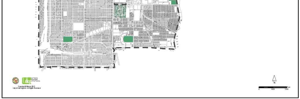
7 Survey Area Map Southeast Los Angeles Community Plan Area 6
8 Topography and Street Geography The Southeast Los Angeles CPA is located in the flat plain of the central Los Angeles Basin that falls to the south of the Santa Monica Mountains. Aside from gradual changes in elevation, the area is generally flat. There are no major land formations or waterways that define the area. Rather, the CPA is bounded and shaped by many man made features, including wide boulevards that traverse much of the city. The northern section of the CPA falls within the historic boundaries of the Spanish and Mexican era Pueblo de Los Angeles and the City of Los Angeles that was incorporated in In this portion of the city, the streets are skewed diagonally at a 36 degree northeast angle, following the plan of early Spanish settlers. The rest of the CPA was laid in a grid that follows a northsouth axis. Three major freeways are located within or adjacent to the CPA, which is roughly bounded on the west by Interstate 110 (Harbor Freeway), on the north by Interstate 10 (Santa Monica Freeway), and on the south by Interstate 105 (Century Freeway). Interstate 110 is sited between Flower Street and Grand Avenue. It is set below grade, with ramps set above the freeway and street level in the northern portion of the CPA. As the freeway moves farther south towards Slauson Avenue, it transitions to being set above street level. Interstate 10 does not intersect the CPA; it is located slightly north of Washington Boulevard, the northern boundary of the CPA. Interstate 105 is sited above street level. The freeways create numerous overpasses and onramps with a physical and visual impact on the neighborhoods in the western and southern portions of the CPA. Many of the major thoroughfares of the area are wide avenues and boulevards that functioned historically as streetcar, motorcar, and railroad routes. These transportation routes were instrumental in the historic development of neighborhoods within the CPA. Commercial corridors developed along major routes, and later residential and commercial development also took advantage of these routes that connected to nearby industrial areas. The major east west thoroughfares crossing the CPA are (from north to south): Washington Boulevard, Adams Boulevard, Jefferson Boulevard, Martin Luther King Jr. Boulevard (formerly Santa Barbara Avenue), Vernon Avenue, Slauson Avenue, Gage Avenue, Florence Avenue, Manchester Avenue, 92 nd Street, Century Boulevard, 108 th Street, and Imperial Highway. The major north south arteries within the CPA are (from west to east): Figueroa Street, Broadway, Main Street, San Pedro Street, Avalon Boulevard, Central Avenue, Hooper Avenue, Compton Avenue, Alameda Street, and Wilmington Avenue. Southeast Los Angeles Community Plan Area 7

9 Map of Historic Streetcar Routes Southeast Los Angeles Community Plan Area 8
10 Neighborhood Geography The northern section of the Southeast Los Angeles CPA was within the original Los Angeles city boundary (incorporated in 1850). The remainder of the CPA was consolidated or annexed into the City of Los Angeles between 1859 and The CPA includes the neighborhoods of Historic South Central, South Park, Central Alameda, Florence, Green Meadows, Broadway Manchester, and Watts. 1 Watts was an incorporated city prior to its consolidation into the City of Los Angeles. The social and cultural history of these neighborhoods is summarized below. The Southeast Los Angeles CPA developed in a southward pattern beginning in the late 19 th century, as the city s growing network of streetcars allowed for development outside the historic city center. Though the area north of Slauson Boulevard was largely built out by the late 1910s, at this time the land to the south was still largely undeveloped and relatively remote. Much of it was used for vegetable and fruit cultivation by Chinese and Japanese residents. In 1903, however, a group of investors evicted the farmers and constructed the Ascot Park horse racing track at generally the area south of Slauson Boulevard and east of Avalon Boulevard. Referred to as being located in the no man s land on the skinny stretch of territory running from Los Angeles to the sea, 2 Ascot Park quickly became known as a notorious den of gambling and drinking. Its investors hoped to incorporate the area, and though unsuccessful, the larger area was known as Ascot Park until the late teens when the park (which converted to automobile racing from horse racing in the late 1900s) was dissolved altogether. The removal of the vast acreage of Ascot Park freed the land for residential and industrial development, which ensued at a monumental pace south of Slauson Boulevard in the 1920s. The Southeast Los Angeles CPA became the center of the city s African American community during the first half of the 20 th century. The African American community in Los Angeles was first concentrated in the historic city center, around the neighborhood that is now Little Tokyo. As the community grew, it began moving south after the turn of the 20 th century. Central Avenue was the primary thoroughfare around which this movement and development was centered, and blacks created a vibrant community there. By the late 1920s, the area had become home to jazz clubs, a vibrant social scene and nightlife, as well as black owned businesses. During this time, the area remained racially and ethnically diverse. Despite the increasing concentration of African Americans, they remained in the minority. Whites, Asians, and Hispanics made up the remaining portion of the area s population during 1 Neighborhood names and boundaries were derived from: "Mapping L.A. Los Angeles Times." Mapping L.A. Los Angeles Times. Web. 09 September < 2 Ascot Park in No Man s Land, Los Angeles Times, 15 January Southeast Los Angeles Community Plan Area 9
11 this period. It was not until the 1930s that the demographics in the area began to shift as these groups moved out of the area, and blacks became an increasing percentage of the population. Large numbers of African Americans moved to Los Angeles in the late 1920s and 1930s, drawn by the promise of jobs and homeownership. Prevented from moving farther west by racially restrictive covenants, they moved into the neighborhoods of Southeast Los Angeles. By 1940, for example, the neighborhood of Watts was 35 percent African American. As the black population increased, tensions rose between the black community in Watts and the white communities in adjacent areas. Racial covenants became enforced more fiercely as African Americans became a more noticeable presence in the city and Anglo Americans attempted to maintain their separation. Blacks became restricted to the area between Alameda Street on the east, San Pedro Street on the west, and Slauson Avenue on the south. Those who attempted to move outside this proscribed area met with resistance, at times intimidating and violent. The advent of World War II brought about an explosion in the city s population. The area became overcrowded as people flooded into the city seeking jobs in the defense industry, but the boundaries of the area around Central Avenue remained enforced by restrictive covenants. The postwar era continued these trends. It was in the postwar era that Central Avenue began its decline in earnest as overcrowding and deteriorating conditions brought about by the influx of migrants during the war only worsened. Middle class blacks began moving out of the area after racial covenants were struck down by the Supreme Court case Shelley v. Kraemer in 1948, and the center of the prosperous black community shifted westward. In the decades after World War II, movement into the area continued, and the population became ever increasingly African American. However, the notable and unifying businesses and institutions that had existed along Central Avenue moved westward as well, leaving the community around Central Avenue underserved and lacking in businesses and institutions. The neighborhood of Watts developed as a separate city (incorporated in 1907) at the southernmost end of the CPA prior to being consolidated in What became the area of Watts was originally a portion of the Rancho La Tajauta. The land was devoted to cattle ranching. Farmers began moving into the area in the 1870s and the land was subdivided into smaller acreage. The railroad arrived in Watts after the turn of the 20 th century, spurring development. The area was a diverse mixture of white, African American, Japanese/Japanese American, and Mexican/Mexican American residents. Its cheap land prices attracted working class residents. For much of its history, Watts had been lacking in the kinds of services and community institutions that served Central Avenue. This was largely a result of its distance from the remainder of the city. This was only exacerbated by the exodus of middle class blacks and community institutions after World War II. This lack of services plagued the community in the 1950s and 1960s. Tensions mounted, ultimately contributing to the Southeast Los Angeles Community Plan Area 10
12 Watts Riots in August During the five days of civil unrest, nearly a thousand buildings were destroyed, leaving a permanent mark on the built environment of the area. Types of Development Most of the Southeast Los Angeles CPA was occupied by ranchos in its earliest period of development after European settlement. There are no resources remaining from this period in the CPA. The earliest residential subdivisions were developed in the northeastern neighborhoods of the CPA nearest to Downtown during the real estate boom of the 1880s that followed the connection of Los Angeles to the transcontinental railroad network. Development extended southward from the city center along streetcar lines in the late 19 th and early 20 th centuries. The CPA largely comprises single family neighborhoods, which followed a typical development pattern with commercial corridors along larger streets and single family residential development along smaller, gridded streets in between. Multi family duplex and fourplex property types are scattered throughout these early developments. Commercial development along major thoroughfares typically includes historic theaters, restaurants, one to three story mixed use commercial and residential buildings, gas stations, and banks. The majority of resources from this period of development date from the 1890s to the 1920s. Development in the southern portion of the CPA (except Watts, which is discussed below) largely occurred during the boom of the 1920s. It included similar patterns of development to those in the northern portion of the CPA, comprising mostly singlefamily neighborhoods with commercial properties located on busy thoroughfares. Residential lots were generally long and narrow and were laid out along a regular grid pattern of streets. Commercial development was laid out to accommodate the streetcar and, later, the automobile. Even though the CPA was largely built out by the 1930s, some redevelopment and infill resulted in construction of buildings in the postwar era, largely including commercial buildings and public housing complexes. Institutional resources occurring throughout the CPA include religious buildings, schools, and public facilities such as Department of Water and Power buildings. These resources are typically sited within residential neighborhoods or along commercial corridors and are generally contemporaneous with adjacent residential development. There is a significant amount of industrial development in the CPA, and there are large portions zoned for industrial use along Alameda Street and Slauson Avenue. 3 A small residential tract planned and constructed by the Goodyear Tire and Rubber Company is located adjacent to the former site of the Goodyear industrial plant; this development is an extremely rare example of purpose built worker housing in Los Angeles. 3 As mentioned earlier in this report, industrially zoned properties were not surveyed as part of this project. They will be surveyed at a later date. Southeast Los Angeles Community Plan Area 11
13 The city of Watts, though relatively remote from the young city of Los Angeles, developed during the late 19 th century and was incorporated in The development of Watts was also reliant on the streetcar, which connected the small enclave to the larger city of Los Angeles. Today, Watts comprises neighborhoods of mainly singlefamily residences dating to the late 19 th and early 20 th centuries as well as several large housing complexes that were constructed during World War II to house defense workers. After the war several of these housing developments were expanded in response to the substandard living conditions in many of the city s poorest neighborhoods. After several years of planning, the Martin Luther King Jr. Shopping Center was completed in The ten acre site replaced the historic commercial center of the community that was damaged during the civil unrest in The construction of a large network of freeways during the 1950s and 60s enabled widespread development in distant stretches of the greater Los Angeles region and relieved automobile congestion on surface streets. However, their construction also had deleterious impacts on the urban environment, such as bisecting neighborhoods and displacing residents who lived in their paths. The Interstate 110 (Harbor) Freeway and Interstate 105 (Century) Freeway traverse the neighborhoods of the Southeast Los Angeles CPA, generally above grade. The freeways have a visual and physical impact on existing building stock, altering the logical cohesion of historic subdivisions and creating boundaries where boundaries did not historically exist. The freeways in and of themselves are significant feats of modern civil engineering and urban planning; however, their impacts on historic neighborhoods in Los Angeles cannot be ignored. 4 Designated Resources The following map depicts previously designated resources within the Southeast Los Angeles CPA. These include properties listed in the National Register of Historic Places (NR) or the California Register of Historical Resources (CR), as well as locally designated Los Angeles Historic Cultural Monuments (HCM) and Historic Preservation Overlay Zones (HPOZ). 4 The freeway system of Los Angeles will be studied in its entirety during a later phase of. Southeast Los Angeles Community Plan Area 12


14 Southeast Los Angeles Community Plan Area 13
15 Community Plan Area Survey Methodology The survey of the Southeast Los Angeles CPA was conducted using the methodology established by the OHR for. 5 GPA and Chattel staff utilized tablet PCs in the field. In order to make the large survey area more manageable, GPA divided the Southeast Los Angeles CPA into smaller quadrants using major thoroughfares and logical neighborhood boundaries as a guide. Once neighborhood boundaries and identities had been established, cursory pre field research was conducted to help acquaint surveyors with the neighborhoods and communities within the CPA, using GPA s in house library of books, periodicals, and journals related to the architecture, history, and development of Los Angeles. Prior to going into the field to record properties using the survey database, a thorough reconnaissance survey of the CPA was conducted. A reconnaissance team composed of one senior staff representative from each firm (one each from ARG, GPA, and Chattel) drove the entire survey area together in order to compile a list of resources to be recorded at a later date. During this initial reconnaissance phase, surveyors became more acquainted with the geography and resources of the survey area, flagged resources to be recorded, identified concentrations of resources that might later be recorded as eligible historic districts and planning districts, and developed lists of prefield research tasks that would help inform the field survey. For use in the reconnaissance phase, ARG created Geographic Information Systems (GIS) maps of each neighborhood; these maps were printed for use in the field. A blank map showing only street names and parcel boundaries was used by surveyors in the field for notes and comments about resources identified during the reconnaissance phase. Another map featured parcels shaded by decade of building construction, which helped to illustrate chronological development patterns and concentrations of resources. Once the reconnaissance survey was complete, a preliminary list of potential historic districts and planning districts within the CPA was compiled. This, in addition to other individual resources identified in the reconnaissance phase, helped guide pre field research. To inform the documentation and evaluation of historic districts, GPA and Chattel staff conducted research using sources such as Sanborn Fire Insurance Maps, tract maps from the Los Angeles Bureau of Engineering, and historic Los Angeles Times articles from the archives of the Los Angeles Public Library. This research helped with the identification of historic tract names and boundaries, names of tract subdividers, dates of subdivision, and original building uses and footprints. 5 For more information about the methodology, see OHR s Field Survey Results Master Report. Southeast Los Angeles Community Plan Area 14
16 Upon completion of reconnaissance and pre field research, survey teams embarked on the documentation phase with the survey database. Survey teams consisted of two people: one staff member meeting the Secretary of the Interior s Professional Qualifications Standards in the discipline of architectural history and one intern. The fieldwork was completed using the methodology developed by the OHR for. For the documentation of individual properties, staff members typically drove from property to property; one person would exit the vehicle to take the photo from the public right of way while the other staff member began the evaluation. Historic districts and planning districts were mapped out during the reconnaissance survey and then further evaluated and edited after intensive survey in the field. Research was ongoing even during the documentation phase, as supplemental research tasks were identified to assist with resource evaluations. Post field research tasks included the further examination of tract maps and Sanborn maps, as well as propertyspecific research such as acquiring original building permits in order to determine original owner and architect/builder. Additional research focused on the history of public schools, public housing projects, and churches in the CPA. Sources for this research included United States Census records, local periodicals including the Los Angeles Times and Los Angeles Sentinel, city directories, historic photographs, and Los Angeles County Tax Assessor records. Summary of Findings The following discussion of Property Types, Contexts, and Themes relates to the resources identified and recorded as eligible for designation. Summary of Property Types The Southeast Los Angeles CPA largely comprises single family residential neighborhoods. Although a variety of other property types exist, the patterns of development in this area were conducive to widespread single family residential development. The neighborhoods in Historic South Central, South Park, Central Alameda, Florence, Broadway Manchester, Green Meadows, and Watts feature concentrations of late 19 th and early 20 th century single family residences. These neighborhoods developed primarily due to their proximity to historic streetcar routes. Concentrations of single family residences that were identified as being eligible for historic district designation typically conveyed their significance both as being representative of a particular style and as retaining character defining features of a streetcar suburb, such as consistent setbacks, narrow lots, street landscaping, and streets laid out on a grid. Though they were located near streetcar lines, these Southeast Los Angeles Community Plan Area 15
17 neighborhoods often feature accommodation for automobiles, such as detached garages and paved driveways. Many of the residential buildings dating to the late 19 th and early 20 th centuries in the Southeast Los Angeles CPA have endured alterations over time, such as replacement windows and doors, stucco finish over original wall cladding materials, and the removal of features such as window surrounds and trim. Due to a preponderance of such alterations, only one eligible historic district was identified in the CPA. Concentrations of buildings that exhibit an intact sense of time and place due to consistent massing, scale and streetscape features but do not retain sufficient integrity for historic district designation were recorded as planning districts. Multi family residences exist in the survey area as well; generally, they are intermittently located in predominantly single family residential neighborhoods. Multifamily development in the CPA typically consists of duplexes, fourplexes, and small apartment buildings that are low scale and congruous with the surrounding singlefamily neighborhoods. Eligible multi family buildings were mainly recorded as individual resources that are significant examples of the property type and/or their representative architectural style. Scattered throughout the CPA are bungalow courts from the early 20 th century, designed in a variety of popular architectural styles including Craftsman and Mission Revival. A number of public housing complexes are located throughout the CPA; those recorded as eligible are significant as early examples of public and defense housing in Los Angeles. Commercial property types are commonly found on major thoroughfares running northsouth and east west through the CPA. Although few intact examples of streetcar related commercial development still remain in Los Angeles, a small number were identified in the CPA. Although no historic districts of commercial buildings were identified, one concentration of commercial buildings was recorded as a planning district. This district, Broadway Manchester Planning District, was identified as a good example of a neighborhood commercial district developed largely between the 1910s and the 1940s. Most often, commercial buildings were recorded individually. Those that were recorded were typically exemplary of the property type or a particular style; these examples included one and two story commercial buildings, car service/gas stations, and banks. The CPA has a number of institutional property types that served local residential communities and continue to do so. Common eligible institutional properties include churches, schools, and government buildings such as fire stations and Department of Water and Power facilities. Many are individually eligible as exemplary of the property type and their representative architectural style. Southeast Los Angeles Community Plan Area 16
18 Finally, a number of non parcel resources were identified in the CPA. These include air raid sirens, uniform street trees that appeared to date from a neighborhood s original subdivision, and landscaped medians. Summary of Contexts and Themes Many of the contexts and themes of the Citywide Historic Context Statement are represented in the Southeast Los Angeles CPA. Following are examples of the common Contexts and Themes used in the survey and representative examples of eligible resources. For a complete list of all individual resources identified as meeting eligibility standards and criteria for the National Register, California Register, and/or HCM/HPOZ, please refer to Appendix A. Appendix B contains a complete list of all non parcel resources identified as meeting eligibility standards and criteria for the National Register, California Register, and/or HCM/HPOZ. For a complete list of historic districts identified as meeting eligibility standards and criteria for the National Register, California Register, and/or HCM/HPOZ, please refer to Appendix C. Southeast Los Angeles Community Plan Area 17


19 Context: Pre Consolidation Communities of Los Angeles, Theme: Watts, Sub Theme: Important Events in Watts History, Resources evaluated under this context/theme include residential development that pre dates the consolidation of Watts into the City of Los Angeles. The resources are rare intact representations of the pre consolidation period of development in Watts and are associated with early development patterns within the original Watts city limits. The single family residences depicted below are examples of resources recorded under this context/theme, which are mostly early 20 th century vernacular cottages with hipped or gabled roofs. Address: 2118 E. 113 th Street Address: 9304 S. Beach Street Date: 1909 Date: 1910 Address: 2271 E. 108 th Street Address: S. Kalmia Street Date: 1903 Date: 1903 Southeast Los Angeles Community Plan Area 18


20 Context: Residential Development and Suburbanization, Theme: Early Residential Development, Sub Theme: Early and Rare Single Family Residential Development, Resources were determined to be eligible as significant examples of early residential development within the CPA if they largely pre date the development of surrounding neighborhoods. In the Southeast Los Angeles CPA, this includes rare examples of late 19 th century residences, some of which were constructed before or during the boom of the 1880s. These resources represent the earliest pattern of residential development in the area. As illustrated below, the residences evaluated often display shiplap siding and a truncated hipped roof. Address: 3708 S. Paloma Street Address: 5864 S. Brentwood Street Date: 1885 Date: 1885 Address: 4360 S. McKinley Avenue Address: 444 E. Adams Boulevard Date: 1894 Date: 1885 Southeast Los Angeles Community Plan Area 19


21 Context: Residential Development and Suburbanization, Sub Context: Multi Family Residential Development, Theme: Multi Family Residential, Sub Theme: The Bungalow Court, Bungalow courts are a multi family housing type found throughout Los Angeles. Examples located in Southeast Los Angeles usually date from the 1920s and are typically located in neighborhoods comprising a variety of single and multi family property types. Eligible bungalow courts were designed in a variety of styles including Craftsman and Mission Revival. All eligible examples exhibit high quality of design and distinctive site planning. The following are three representative examples of bungalow courts that were identified as eligible under this context/theme. Address: 761 E. 41 st Place Address: E. 52 nd Street Date: 1913 Date: Circa 1922 Address: W. 71 st Street Date: 1924 Southeast Los Angeles Community Plan Area 20


22 Context: Residential Development and Suburbanization, Sub Context: Multi Family Residential Development, Theme: Multi Family Residential, Sub Theme: Public and Defense Housing, In the years during and immediately following World War II, a number of public housing complexes were constructed in Los Angeles. With support from the 1937 Federal Housing Act (FHA), the Housing Authority of the City of Los Angeles constructed these multi family complexes in response to urban housing shortages and substandard living conditions. Working with teams of notable architects, landscape architects, urban planners and builders, the program aimed to alleviate overcrowding and provide healthy, safe living conditions for residents at a low cost. Several public housing complexes were constructed in the Southeast Los Angeles CPA between 1941 and Early examples exhibit Garden City planning principles, such as a separation of vehicular and pedestrian traffic; superblock site planning, with internal circulation systems deviating from the city grid; expansive, common courtyard and green spaces; and a site plan that provides all residents with easy access to common outdoor spaces, fostering community interaction. Eligible examples, including the two depicted below, are significant as exemplifying city planning and public welfare practices of the era. Address: 88 th Place between Avalon Boulevard and McKinley Avenue Name: Avalon Gardens Date: Address: 55 th Street between Alameda Street and Long Beach Avenue Name: Pueblo del Rio Date: , 1944 (annex) Southeast Los Angeles Community Plan Area 21


23 Context: Commercial Development, Theme: Commercial Development and the Automobile, s Sub Theme: The Car and Car Services, s Property types recorded under this context/theme include gas stations and car service/repair facilities. They date from the late 1930s and early 1940s and are typically located on major vehicular thoroughfares. They represent early commercial development dedicated to the service and accommodation of the automobile. Extant and intact examples of this property type are relatively uncommon within the CPA and are typically designed in the Streamline Moderne style, such as the two depicted below. Address: 7725 S. San Pedro Street Address: 1119 E. 50 th Street Date: 1940 Date: 1940 Southeast Los Angeles Community Plan Area 22


24 Context: Commercial Development, Theme: Neighborhood Commercial Development, Sub Theme: Early Neighborhood Commercial Development, Early commercial buildings found within the CPA are located on major thoroughfares such as Central Avenue and Avalon Boulevard. They represent the earliest patterns of commercial development within their surrounding neighborhoods. Intact examples of this property type are extremely rare within the CPA and are often wood framed structures designed in a vernacular style. Only two properties were evaluated under this context/theme; both are depicted below. Address: 6401 S. Avalon Boulevard Address: 4909 S. Central Avenue Date: 1904 Date: 1905 Southeast Los Angeles Community Plan Area 23

 and Mid Century Modern (top, right and bottom, left). St.")

25 Context: Public and Private Institutional Development, Sub Context: Religion and Spirituality, Theme: Religion and Spirituality and Ethnic/Cultural Associations, Resources evaluated under this context/theme consisted of religious buildings that are significant for their association with the ethnic communities they historically served. Many of the resources evaluated under this context are located in neighborhoods with single and multi family resources that pre date or are contemporaneous with the resource. They were designed in a number of architectural styles, including Neoclassical (bottom, right) and Mid Century Modern (top, right and bottom, left). St. Paul s Baptist Church and Progressive Society for Spiritual Truth Seekers were also evaluated under the Architecture and Engineering context as exemplary of their respective styles. Address: 2716 E. Stanford Avenue Address: 4800 McKinley Avenue Name: St. Phillip the Evangelist Church Name: Victory Baptist Church Date: 1929 Date: 1940 Address: 110 W. 49 th Street Address: 906 E. 23 rd Street Name: St. Paul s Baptist Church Name: Progressive Society for Spiritual Truth Date: 1948 Date: 1937 Southeast Los Angeles Community Plan Area 24


26 Context: Public and Private Institutional Development, Sub Context: Education, Theme: Public Schools and the LAUSD, Sub Theme: Pre 1933 Long Beach Earthquake, The three resources below were evaluated under the context/theme for Los Angeles Unified School District schools constructed prior to the 1933 Long Beach Earthquake. These buildings date to the 1920s and early 1930s and are located on larger campuses that were further developed in the post World War II era. The buildings at John C. Fremont High School and 109 th Street Elementary School (top left and right, respectively) were also recorded under the context of Architecture and Engineering as exemplary of their architectural styles. Address: 7676 S. San Pedro Street Address: S. McKinley Avenue Name: John C. Fremont High School Name: 109 th Street Elementary School Date: 1923 Date: 1930 Address: 9211 S. Grape Street Name: 92 nd Street Elementary School Date: 1931 Southeast Los Angeles Community Plan Area 25


27 Context: Public and Private Institutional Development, Sub Context: Education, Theme: Public Schools and the LAUSD, Sub Theme: Post 1933 Long Beach Earthquake, A small handful of resources were evaluated under the context/theme for schools constructed after the 1933 Long Beach Earthquake. A number of the schools are located within early 20 th century residential neighborhoods that pre dated the earthquake. Some are located on parcels that contained school buildings constructed prior to 1933 but were damaged during the earthquake and replaced. These buildings reflect changes in building codes and design required for schools following the earthquake. Eligible resources represent a variety of sub types, including multi building campuses of high schools and elementary schools. Most of the resources were also evaluated under the Architecture and Engineering context as exemplary of their representative styles, which included the PWA Moderne, Streamline Moderne, and Spanish Colonial Revival styles. Below are four examples of properties evaluated under this context/theme. Address: 370 W. 43 rd Street Address: 4410 S. McKinley Avenue Name: West Vernon Avenue School Name: George Washington Carver Junior High School Date: 1937 Date: 1934 Address: 112 th and San Pedro Streets Address: 66 th and San Pedro Streets Name: Gompers Middle School Name: 66 th Street Elementary School Date: 1937 Date: 1937 Southeast Los Angeles Community Plan Area 26


28 Context: Public and Private Institutional Development, Sub Context: Government Infrastructure and Services, Theme: Municipal Water and Power, Sub Theme: Distributing and Receiving Stations, A small number of resources were evaluated under this context/theme as excellent examples of distributing and receiving stations constructed by the Department of Water and Power. The need for government infrastructure was associated with the residential growth of the area and the resources documented under this context are frequently some of the earliest non residential resources in their neighborhoods. As illustrated below, these resources exhibit a strong consistency in size and massing that resulted from the use and space requirements for the equipment they contained. Distributing Stations 4 and 19 (top left and right, respectively) were designed by master architect Frederick L. Roehrig. Address: 5716 S. Figueora Street Address: 3005 S. Trinity Street Name: Distributing Station #4 Name: Distributing Station #19 Date: 1929 Date: 1925 Address: 9615 S. Central Avenue Address: 4332 Woodlawn Avenue Name: Receiving Station B Name: Distributing Station #32 Date: 1927 Date: 1928 Southeast Los Angeles Community Plan Area 27

; Federal Model 5, Bird House (left); and Federal Model 500T, Rotating.")
29 Context: Public and Private Institutional Development, Sub Context: Military Institutions and Activities, Theme: The Cold War, Sub Theme: Air Raid Sirens and Civil Defense, Air raid sirens were installed throughout Los Angeles during the World War II and Cold War periods. Air raid sirens within the CPA are located near prominent intersections along commercial corridors that border residential neighborhoods. Ten resources were documented under this sub theme in the CPA. They include rare, intact examples of three different air raid siren models, Federal Model SD 10, Wire Spool (right); Federal Model 5, Bird House (left); and Federal Model 500T, Rotating. All were installed on a freestanding support pole. Address: East side of Compton Avenue at 114 th Street Name: Air Raid Siren No. 183 Address: North side of Walnut Street, east of Central Avenue Date: circa 1940 Name: Air Raid Siren No. 68 Date: circa 1940 Southeast Los Angeles Community Plan Area 28


30 Context: Architecture and Engineering, Theme: Late 19 th and Early 20 th Century Architecture, Sub Theme: Queen Anne, The northern neighborhoods of the CPA were some of the first sections of the city to be subdivided during the late 1880s land boom. Consequently, Southeast Los Angeles has some of the few remaining examples of the city s earliest residential suburban development, many of which were constructed in the Queen Anne style. A number of those identified are isolated examples located on residential streets that were further developed in the early 20 th century. Those evaluated as eligible are exemplary, intact examples of the style; six examples are depicted below. Address: 422 E. 21 st Street Address: 1214 E. 27 th Street Date: 1890 Date: 1898 Address: 212 E. 25 th Street Address: 123 E. 25 th Street Date: 1895 Date: 1888 Southeast Los Angeles Community Plan Area 29


31 Address: 258 E. 29th Street Address: 3122 S. Maple Avenue Date: 1894 Date: 1902 Southeast Los Angeles Community Plan Area 30


32 Context: Architecture and Engineering, Theme: Late 19 th and Early 20 th Century Architecture, Sub Theme: Vernacular Gabled Cottage, Vernacular gabled cottages are found throughout the CPA and are often some of the earliest buildings in their neighborhoods. This was a relatively common style and type for single family residences in early Los Angeles; however, many of those that remain have been altered. Those evaluated as eligible are rare, intact examples of the style and type. Because these houses often represent some of the earliest residential development in their surrounding areas, they were often also recorded under the context of Early Residential Development. Address: 124 E. 23 rd Street Address: 1234 E. Adams Boulevard Date: 1889 Date: 1900 Address: 816 E. 21 st Street Address: 1544 E. Vernon Avenue Date: 1905 Date: 1896 Southeast Los Angeles Community Plan Area 31


33 Context: Architecture and Engineering, Theme: Late 19 th and Early 20 th Century Architecture, Sub Theme: Vernacular Hipped Cottage, Like the vernacular gabled cottage, the vernacular hipped cottage is a relatively common style and type for single family residences in the CPA. However, many of those that remain have been altered. Only intact resources that are excellent examples of their style and type were evaluated as eligible. These residences are typically modest in scale and one story in height. Many display Neoclassical influences, as illustrated below. Address: 1678 E. Martin Luther King Jr. Blvd. Address: 1152 E. 25 th Street Date: 1904 Date: 1901 Address: 1012 E. 55th Street Address: 1042 E. 55 th Street Date: 1899 Date: 1906 Southeast Los Angeles Community Plan Area 32


34 Address: 1324 E. Adams Boulevard Address: 187 W. 43 rd Place Date: 1897 Date: 1905 Address: 947 E. 21 st Street Address: 235 W. 43rd Place Date: 1902 Date: 1905 Southeast Los Angeles Community Plan Area 33


.")
35 Context: Architecture and Engineering, Theme: Late 19 th and Early 20 th Century Architecture, Sub Theme: Shingle Style, While the Shingle Style is not as common as other architectural styles in Southern California, several fine examples are located in the CPA. They are typically two story, single and multi family residences. Identified resources, such as the ones illustrated below, exhibit a high quality of design and craftsmanship. Indicative of the style, they display shingle exteriors and gabled roofs with shallow overhanging eaves. One of the more distinctive examples in the CPA is located at 4256 S. Grand Avenue (top, left). It is a multi family residence with Chalet influences. Address: 824 E. Adams Boulevard Address: 351 E. 33 rd Street Date: 1910 Date: 1905 Address: 223 W. 40 th Place Date: 1905 Southeast Los Angeles Community Plan Area 34


36 Context: Architecture and Engineering, Theme: Arts and Crafts Movement, Sub Theme: Craftsman, The Craftsman style is common in Southern California. The style was applied to both single family and multi family residential properties in the CPA. Multi family residential properties represent a relatively rare application of the style and are most often fourplexes. Resources evaluated under this context were recorded as excellent, intact examples of their style. Identified resources, such as the examples depicted below, exhibit a high quality of design and craftsmanship. They display the horizontal orientation, overhanging eaves, exposed rafter tails, and wood siding indicative of the style. Address: 224 E. 23 rd Street Address: 700 E. 46 th Street Date: 1910 Date: 1913 Address: 215 E. 25 th Street Address: 734 E. 32 nd Street Date: 1902 Date: 1907 Southeast Los Angeles Community Plan Area 35


37 Address: 4248 S. Grand Avenue Address: 5017 S. Wall Street Date: 1910 Date: 1908 Southeast Los Angeles Community Plan Area 36


38 Context: Architecture and Engineering, Theme: Arts and Crafts Movement, Sub Theme: American Foursquares or Prairie Boxes, This context/theme was used for the evaluation of intact residences exemplifying the American Foursquare or Prairie Box style on both modest and grand scales. Resources within this context are intact examples of the style and are commonly among the earliest buildings in their neighborhoods. Identified resources exhibit a high quality of design and craftsmanship. All feature the distinctive hipped roof and boxy massing typical of the style. They often exhibit Queen Anne, Neoclassical, or Craftsman stylistic influences. The style was applied to both single and multi family residences, as illustrated below. Address: 210 W. Vernon Avenue Address: 4101 S. Trinity Street Date: 1895 Date: 1908 Address: 826 E. 21 st Street Address: 258 E. 28 th Street Date: 1905 Date: 1908 Southeast Los Angeles Community Plan Area 37


39 Address: 156 E. 36 th Street Address: 800 E. Adams Boulevard Date: 1895 Date: 1909 Southeast Los Angeles Community Plan Area 38

 and multi family residences,")


40 Context: Architecture and Engineering, Theme: Mediterranean and Indigenous Revival Architecture, Sub Theme: Spanish Colonial Revival, Spanish Colonial Revival style resources occur throughout the CPA, although in limited numbers relative to other areas of the city. Property types evaluated under this context include churches (top row) and multi family residences, specifically courtyard apartments and apartment houses (bottom row). Resources are found eligible under this context/theme if they are intact, excellent examples of their style and exhibit high quality of design and distinctive features. Address: 310 W. 95 th Street Address: 6315 Main Street Name: Faith Lutheran Church Name: St. Columbkill Church Date: 1927 Date: 1923 Address: 1168 E. 52 nd Street Address: 446 W. 57 th Street Date: 1930 Date: 1924 Southeast Los Angeles Community Plan Area 39
 and residential buildings, such as bungalow courts (below, right).")

41 Context: Architecture and Engineering, Theme: Mediterranean and Indigenous Revival Architecture, Sub Theme: Mission Revival, The Mission Revival style is relatively uncommon in Los Angeles. Intact examples are most commonly institutional buildings such as schools and churches (below, left) and residential buildings, such as bungalow courts (below, right). The style is characterized by its stucco finish, arched window and door openings, and a shaped Mission style parapet. Only a few intact Mission Revival resources were identified and recorded in the CPA; those that were are exemplary of the style and exhibit high quality design through distinctive features. Address: Compton Avenue Address: 5017 S. San Pedro Street Name: Holy Redeemer Church Date: 1925 Date: 1948 Southeast Los Angeles Community Plan Area 40


42 Context: Architecture and Engineering, Theme: American Colonial Revival, Sub Theme: Dutch Colonial Revival, Resources evaluated under the Dutch Colonial Revival context/theme occur primarily in the northeastern quadrant of the CPA. They were recorded as excellent and rare examples of their style. Many were constructed in the late 19 th century and represent the earliest pattern of development in their neighborhoods. Resources evaluated under this context/theme display the architectural features common to the style, including a front gambrel roof and clapboard exterior cladding. Many of those identified are located adjacent to or within proximity of each other on the same street, such as the four depicted below. Address: 616 E. 21 st Street Address: 620 E. 21 st Street Date: 1895 Date: 1895 Address: 1207 E. 21 st Street Address: 629 E. 21 st Street Date: 1899 Date: 1902 Southeast Los Angeles Community Plan Area 41

 is not only exemplary of the Streamline Moderne style but is also significant for its association with the African American community in Southeast Los")
43 Context: Architecture and Engineering, Sub Context: LA Modernism, Theme: Related Responses to Modernism, Sub Theme: Streamline Moderne, Though not a common style of architecture in the CPA, the Streamline Moderne style was used fairly regularly in the design of institutional buildings such as Los Angeles Unified School District schools constructed after the Long Beach earthquake in The Saints Home Church, now Templo De Refugio Del Cladic (below, left), is an unusual example of the style applied to a religious building. Thomas Jefferson High School (below, right) is not only exemplary of the Streamline Moderne style but is also significant for its association with the African American community in Southeast Los Angeles, with countless notable alumni. Resources that were recorded as significant examples of the Streamline Moderne style retain the essential character defining features of the style, such as rounded corners, smooth wall surfaces, minimal ornamentation, speedlines or horizontal scoring on exterior finishes, and windows punched into walls, without elaborate frames or surrounds. Address: 1420 E. 20 th Street Address: E. 41 st Street and Compton Avenue Name: Saints Home Church of Christ Name: Thomas Jefferson High School Date: Date: Southeast Los Angeles Community Plan Area 42

 Church Date: 1954 Address: 4524 S.")
44 Context: Architecture and Engineering, Sub Context: LA Modernism, Theme: Postwar Modernism, Sub Theme: Mid Century Modern, Resources evaluated under this context/theme represent the post war development of Modernism in Los Angeles. There were very few Mid Century Modern resources in the CPA; only three were identified and recorded. They include the two churches depicted below. Address: S. Central Avenue Name: Grant African Methodist Episcopal (AME) Church Date: 1954 Address: 4524 S. Compton Avenue Name: Church of God in Christ Date: 1949 Southeast Los Angeles Community Plan Area 43

 depicted below, evokes the time and place of their historic period and")

45 Context: Residential Development and Suburbanization Theme: Streetcar Suburbanization, Sub Theme: Suburban Planning and Development, A number of intact concentrations of street trees were evaluated as representative examples of historic tract features under the Streetcar Suburbanization theme of the Residential Development and Suburbanization context. These trees were planted as part of the cohesive development of residential subdivisions. The presence of these tract features, such as the mature Mexican fan palms (Washingtonia Robusta) depicted below, evokes the time and place of their historic period and context of development. Address: 43 rd Street between Avalon Boulevard and McKinley Avenue Address: Towne Avenue between 46 th Street and Vernon Avenue Type: Mexican Fan Palms Type: Mexican Fan Palms Date: circa 1905 Date: circa 1905 Address: Martin Luther King Jr. Boulevard between Morgan and Compton Avenues Type: Mexican Fan Palms Date: circa 1905 Southeast Los Angeles Community Plan Area 44

 in 1920, hired the preeminent architectural partnership of Sumner Hunt and Silas Burns to construct these modest bungalows.")
, Craftsman (top, right),")
46 Context: Residential Development and Suburbanization Theme: Company Built Worker Housing, One small subdivision of housing planned and developed specifically to accommodate industrial workers was identified in the Southeast Los Angeles CPA near the intersection of Slauson Avenue and Avalon Boulevard. This tract, developed by the Goodyear Tire and Rubber Company, was located within walking distance of their massive industrial plant east of Avalon Boulevard. Goodyear, whose work force comprised 2,500 individuals (predominantly men) in 1920, hired the preeminent architectural partnership of Sumner Hunt and Silas Burns to construct these modest bungalows. The preliminary plan called for construction of 800 one and two story houses on the 80 acres. Initial construction occurred in 1920 and included 49 houses based on a small handful of models designed in a variety of styles popular at the time: Tudor Revival (top, left), Craftsman (top, right), and an unusual, modest adaptation of the Prairie Style (bottom, left). Although the rest of the development was never built, those that remain are an exceptionally rare collection of purpose built worker housing in Los Angeles. Address: 315 East 59 th Place (contributor to the Address: 345 East 59 th Place (contributor to the Goodyear Gardens Historic District) Goodyear Gardens Historic District) Date: 1920 Date: 1920 Address: 427 East 59 th Place (contributor to the Goodyear Gardens Historic District) Date: 1920 Southeast Los Angeles Community Plan Area 45
Historic Resources Survey Report Harbor Gateway Community Plan Area
 Historic Resources Survey Report Prepared for: City of Los Angeles Department of City Planning Office of Historic Resources Prepared by: Galvin Preservation Associates El Segundo, CA July 2012 Table of
Supplemental Historic Resources Survey Report Industrial Zone Properties in the Southeast Los Angeles Community Plan Area
 Supplemental Historic Resources Survey Report Industrial Zone Properties in the Southeast Los Angeles Community Plan Area Prepared for: City of Los Angeles Department of City Planning Office of Historic
California Preservation Foundation Historic Context Statements HISTORIC RESOURCES GROUP
 California Preservation Foundation Historic Context Statements WHAT IS A HISTORIC CONTEXT STATEMENT? In order to understand the historic significance of resources in a given area, it is necessary to examine
Southeast Los Angeles Industrial Zone Properties Individual Resources January 2015
 Year built: 1938 1600 E 16TH ST 1604 E 16TH ST 1610 E 16TH ST 1614 E 16TH ST 1618 E 16TH ST 1620 E 16TH ST 1614 S COMPTON AVE 1620 S COMPTON AVE 1622 S COMPTON AVE 1626 S COMPTON AVE Moderne, Streamline
M E M O R A N D U M PLANNING AND COMMUNITY DEVELOPMENT DEPARTMENT CITY OF SANTA MONICA PLANNING DIVISION
 M E M O R A N D U M 10-B PLANNING AND COMMUNITY DEVELOPMENT DEPARTMENT CITY OF SANTA MONICA PLANNING DIVISION DATE: April 9, 2018 TO: FROM: SUBJECT: The Honorable Landmarks Commission Planning Staff 133
Historic Resources Survey Report West Adams-Baldwin Hills-Leimert Community Plan Area
 Historic Resources Survey Report West Adams-Baldwin Hills-Leimert Community Plan Area Prepared for: City of Los Angeles Department of City Planning Office of Historic Resources Prepared by: Architectural
Central City Non-Parcel Resources - 09/02/16
 Non-Parcel Resources Los Angeles St and 8th St, southeast corner No. 10 Theme: s and Civil Defense, 1939-1960 A/C; 1/3; 1/3 Broadway and Olympic Blvd, southwest corner No. 11 Theme: s and Civil Defense,
Historic Resources Survey Report West Adams-Baldwin Hills-Leimert Community Plan Area
 Historic Resources Survey Report West Adams-Baldwin Hills-Leimert Community Plan Area Prepared for: City of Los Angeles Department of City Planning Office of Historic Resources Prepared by: Architectural
Wilshire Non-Parcel Resources 01/26/15
 Non-Parcel Resources Streetlights on 7th Street between Catalina Street and Hoover Street 7th Street Streetlights Year built: 1925 Street Lights and the Bureau of Street Lighting, 1900-1980 Excellent collection
Brentwood - Pacific Palisades Report Non-Parcel Resources 11/26/13
 Non-Parcel Resources Sunset Bl at Mandeville Canyon Rd Air Raid Siren No. 141 Year built: 1940 Context: Public and Private Institutional Development, 1850-1980 Military Institutions and Activities, 1850-1980
Calvert Hills (66-037)
") Calvert Hills (66-037) Calvert Hills, a cohesive neighborhood in northwestern Prince George s County, is an excellent illustration of the residential development on the outskirts of Washington, D.C., in
Calvert Hills (66-037) Calvert Hills, a cohesive neighborhood in northwestern Prince George s County, is an excellent illustration of the residential development on the outskirts of Washington, D.C., in
College Park (66-021)
") College Park (66-021) Old Town College Park is a representative example of the many residential subdivisions that emerged as the suburbs of Washington, D.C. expanded with the advent of the streetcar and
College Park (66-021) Old Town College Park is a representative example of the many residential subdivisions that emerged as the suburbs of Washington, D.C. expanded with the advent of the streetcar and
APPENDIX D: BACKGROUND AND VISION
 APPENDIX D: BACKGROUND AND VISION BACKGROUND A. Specific Plan Location Jordan Downs is located at 9800 Grape Street in Los Angeles, California, 90002. The Jordan Downs Urban Village Specific Plan area
Chapter 8: BEACH SOUTH OF ATLANTIC AVENUE NEIGHBORHOOD PLANNING AREA ANALYSIS
 Chapter 8: BEACH SOUTH OF ATLANTIC AVENUE NEIGHBORHOOD PLANNING AREA ANALYSIS The Beach South of Atlantic Avenue Neighborhood Planning Area includes the parcels adjacent to S Fletcher Avenue from Atlantic
Glenbrooke North. New Westminster s Neighbourhoods Identifying Historical Contexts. Historical Neighbourhood Context Statements 2008
 Historical Neighbourhood Context Statements 2008 Glenbrooke North Fifth Street: wide boulevard, with garden median at south end 1950s subdivision character along much of Eighth Avenue and east of Fourth
Existing Conditions Summary (Draft for Review)
") Existing Conditions Summary (Draft for Review) Prepared by March 16, 2015 Bird s-eye-view of Norwalk in 1899 (Cropped) Existing Conditions Summary (Draft for Review) March 16, 2015 Table of Contents 1.
Existing Conditions Summary (Draft for Review) Prepared by March 16, 2015 Bird s-eye-view of Norwalk in 1899 (Cropped) Existing Conditions Summary (Draft for Review) March 16, 2015 Table of Contents 1.
Cottage City (68-096)
") Cottage City (68-096) Cottage City is one of the smallest incorporated towns in Maryland and was established as a latenineteenth-century railroad suburb. The community is located between the Town of Mount
Cottage City (68-096) Cottage City is one of the smallest incorporated towns in Maryland and was established as a latenineteenth-century railroad suburb. The community is located between the Town of Mount
2. INTRODUCTION 2.1 AUTHORITY 2.2 PURPOSE AND INTENT 2.3 SITE LOCATION
 2. INTRODUCTION 2.1 AUTHORITY The City of Gardena initiated and prepared the Artesia Corridor Specific Plan pursuant to the provisions of California Government Code, Title 7, Division 1, Chapter 3, Article
North Hollywood - Valley Village Non-Parcel Resources 02/13/13
 Non-Parcel Resources West side Bellaire, north of Burbank Air Raid Siren #121 Institutional - Military Air Raid Siren A/C; 1/3; 1/3 North side of Otsego St., east of Bakman Air Raid Siren #15 Institutional
Sherman Oaks - Studio City - Toluca Lake - Cahuenga Pass Non-Parcel Resources 02/26/13
 Non-Parcel Resources Adina Dr between Oakshire and Ellington Adina-Passmore Public Stairway Year built: 1930 Context: Residential Development and Suburbanization, 1850-1980 Theme: Automobile Suburbanization,
Baker Historic District
 DISTRICT DESCRIPTION This is a historically middle-class neighborhood in the South Side, an area annexed by Denver in 1883, consisting of more than 20 tightly interwoven residential subdivisions. The earliest
CHAPTER 2: HISTORIC BACKGROUND
 CHAPTER 2: HISTORIC BACKGROUND The historic town of Eastlake was created on June 22, 1911 when the Eastlake Subdivision was recorded at the Adams County Clerk and Recorder s Office. The Eastlake Investment
2.0 AREA PLANS. Lakeside Business District. Lakeside Business District Land Use Categories:
 Lakeside Business District Lakeside Business District Land Use Categories: Campus Commercial Campus Commercial means a mixture of uses which includes corporate offices, office parks, hotels, commercial,
PRIMARY RECORD Trinomial # NRHP Status Code 3S, 3CS, 5S3 Other Listings Review Code Reviewer Date
 PRIMARY RECORD # NRHP Status Code 3S, 3CS, 5S3 Other Listings Review Code Reviewer Date Page 1 of 6 1252 *Resource Name or # (Assigned by recorder) Old Topanga Canyon Road P1. Other Identifier: *P2. Location:
M E M O R A N D U M PLANNING AND COMMUNITY DEVELOPMENT DEPARTMENT CITY OF SANTA MONICA PLANNING DIVISION
 M E M O R A N D U M 10-A PLANNING AND COMMUNITY DEVELOPMENT DEPARTMENT CITY OF SANTA MONICA PLANNING DIVISION DATE: October 8, 2018 TO: FROM: SUBJECT: The Honorable Landmarks Commission Planning Staff
LAND PARK COMMUNITY PLAN
 LAND PARK Community Plan Part Three : COMMUNITY PLAN AREAS AND SPECIAL STUDY AREAS SACRAMENTO 2030 GENERAL PLAN Contents Community Location...3-LP-3 Community Vision...3-LP-4 Community Profile...3-LP-4
Citywide Historic Resources Inventory Update Survey Report
 City of Santa Monica Citywide Historic Resources Inventory Update Survey Report Prepared for: City of Santa Monica Planning and Community Development Prepared by: Los Angeles, California August 9, 2018
CITY OF MIAMI CEMETERY 1800 N.E. 2 AVENUE
 CITY OF MIAMI CEMETERY 1800 N.E. 2 AVENUE Designation Report City of Miami REPORT OF THE CITY OF MIAMI PLANNING DEPARTMENT TO THE HERITAGE CONSERVATION BOARD ON THE POTENTIAL DESIGNATION OF CITY OF MIAMI
Access Management: An Overview
 Figures 1-5 Below Evolution of development along a highway. In the early stages, land along the road is used for farming with little traffic generated. As time passes, the highway corridor becomes a de
Architectural Inventory Form
 COLORADO CULTURAL RESOURCE SURVEY Page 1 of 8 Official Eligibility Determination (OAHP use only) Rev. 9/98 OAHP1403 Date Initials Determined Eligible National Register Determined Not Eligible National
Central City North Non-Parcel Resources - 09/29/16
 Non-Parcel Resources E 1st Street between Rose and Hewitt (south side) 1st Street Granite Curbs Year built: 1900 Architectural style: No style Sub context: No Sub-context Theme: Event or Series of Events,
Tazewell Pike. Neighborhood Conservation Overlay District Design Guidelines
 Tazewell Pike Neighborhood Conservation Overlay District Design Guidelines Knoxville Knox County Metropolitan Planning Commission November 2, 2000 These design guidelines were: Adopted by the Knoxville
PLANNING COMMISSION REPORT
 PLANNING COMMISSION REPORT REZONING CASE NO. RZ-14-002 REPORT DATE: February 10, 2015 CASE NAME: 9990 W. Alameda Ave. Rezoning PLANNING COMMISSION DATE: February 18, 2015 ADDRESS OF REZONING PROPOSAL:
2. Form and Character. 2.1 Introduction. 2.2 The Downtown Addition Plan. 2.1 Introduction
 2.1 Introduction 2.1 Introduction This section of the Specific Plan describes and illustrates the desired form, character and uses of the Downtown Addition and explains the underlying design principles.
APPENDIX D: Visual and Aesthetic Conditions for NCCU Station Refinement. Durham-Orange Light Rail Transit Project
 APPENDIX D: Visual and Aesthetic Conditions for NCCU Station Refinement Durham-Orange Light Rail Transit Project October 2016 1. Introduction The Combined FEIS/ROD summarizes the effects of the D-O LRT
Reseda West Van Nuys Report Non-Parcel Resources 08/05/15
 Non-Parcel Resources Southwest corner of Arminta Street and Reseda Boulevard Air Raid Siren No. 112 Year built: 1940 Context: Public and Private Development, 1850-1980 Military Institutions and Activities,
Planning Districts INTRODUCTION
 INTRODUCTION To facilitate detailed examination of development prospects for all areas of the community, Delano has been divided into 14 planning districts. The location of these planning districts is
Architectural Inventory Form (page 1 of 5)
") OAHP1403 Rev. 9/98 COLORADO CULTURAL RESOURCE SURVEY (page 1 of 5) Official eligibility determination (OAHP use only) Date Initials Determined Eligible- NR Determined Not Eligible- NR Determined Eligible-
OAHP1403 Rev. 9/98 COLORADO CULTURAL RESOURCE SURVEY (page 1 of 5) Official eligibility determination (OAHP use only) Date Initials Determined Eligible- NR Determined Not Eligible- NR Determined Eligible-
Strategic Growth Area #1 Northampton Boulevard Corridor Area
 Strategic Growth Area #1 Northampton Boulevard Corridor Area Description Strategic Growth Area #1 has established itself as a major employment center in Southside Hampton Roads. Opportunities exist to
FINAL MITIGATION PLAN to address
 CENTRAL CORRIDOR LRT STATE CAPITOL MALL HISTORIC FINAL MITIGATION PLAN February 2010 FINAL MITIGATION PLAN to address Adverse Effects of the Central Corridor LRT Project on the State Capitol Mall Historic
SUBJECT: PREDEVELOPMENT PLAN REVIEW OF PROJECT LOCATED AT 2632 EAST WASHINGTON BOULEVARD ('ST. LUKE MEDICAL CENTER')
") TO: FROM: Honorable Mayor and City Council Planning & Community Development Department SUBJECT: PREDEVELOPMENT PLAN REVIEW OF PROJECT LOCATED AT 2632 EAST WASHINGTON BOULEVARD ('ST. LUKE MEDICAL CENTER')
TO: FROM: Honorable Mayor and City Council Planning & Community Development Department SUBJECT: PREDEVELOPMENT PLAN REVIEW OF PROJECT LOCATED AT 2632 EAST WASHINGTON BOULEVARD ('ST. LUKE MEDICAL CENTER')
POCKET COMMUNITY PLAN
 POCKET COMMUNITY PLAN Part Three : COMMUNITY PLAN AREAS AND SPECIAL STUDY AREAS CONTENTS Community Location... 3-P-3 Community Vision... 3-P-4 Community Profile... 3-P-4 Community Issues... 3-P-6 Land
Request for Statement of Interest in Implementation of the Roosevelt Road Redevelopment Plan
 425 Hillside Avenue Request for Statement of Interest in Implementation of the Roosevelt Road Redevelopment Plan I. INTRODUCTION The is seeking the services of a qualified consulting firm to prepare plans
The impacts examined herein take into account two attributes of aesthetic values:
 IV. ENVIRONMENTAL IMPACT ANALYSIS This section addresses the potential impacts to views and aesthetics as a result of the proposed Project at the Project Site and the development scenarios analyzed for
HISTORIC SITE FORM - HISTORIC SITES INVENTORY PARK CITY MUNICIPAL CORPORATION (10-08) 1 IDENTIFICATION
 1 IDENTIFICATION") HISTORIC SITE FORM - HISTORIC SITES INVENTORY PARK CITY MUNICIPAL CORPORATION (10-08) 1 IDENTIFICATION Name of Property: William Tretheway House Address: 335 Woodside Avenue AKA: City, County: Park City,
HISTORIC SITE FORM - HISTORIC SITES INVENTORY PARK CITY MUNICIPAL CORPORATION (10-08) 1 IDENTIFICATION Name of Property: William Tretheway House Address: 335 Woodside Avenue AKA: City, County: Park City,
HISTORIC SITE FORM - HISTORIC SITES INVENTORY PARK CITY MUNICIPAL CORPORATION (10-08) 1 IDENTIFICATION
 1 IDENTIFICATION") HISTORIC SITE FORM - HISTORIC SITES INVENTORY PARK CITY MUNICIPAL CORPORATION (10-08) 1 IDENTIFICATION Name of Property: Egyptian Theater Address: 328 MAIN ST City, County: Park City, Summit County, Utah
HISTORIC SITE FORM - HISTORIC SITES INVENTORY PARK CITY MUNICIPAL CORPORATION (10-08) 1 IDENTIFICATION Name of Property: Egyptian Theater Address: 328 MAIN ST City, County: Park City, Summit County, Utah
A. WHAT IS A GENERAL PLAN?
 I. Introduction A. WHAT IS A GENERAL PLAN? A general plan is the planning guideline for the future of a city. It contains goals and policies which regulate urban development, the protection of the natural
3.0 LAND USE PLAN. 3.1 Regional Location. 3.2 Existing Conditions Existing Uses. Exhibit Regional Location Map
 3.0 LAND USE PLAN 3.1 Regional Location The Anaheim Resort Specific Plan (ARSP) area is located in the City of Anaheim, which is 35 miles southeast of downtown Los Angeles and 7 miles northwest of Santa
Architectural Inventory Form
 OAHP1403 Rev. 9/98 COLORADO CULTURAL RESOURCE SURVEY Architectural Inventory Form Official eligibility determination (OAHP use only) Date Initials Determined Eligible- NR Determined Not Eligible- NR Determined
Vision & Land Use. Discussion. Historic Preservation Plan. Foggy Bottom Campus Plan:
 Vision & Land Use Foggy Bottom Campus Plan: 2006-2025 Historic Preservation Plan Discussion Community Meeting Presentation August 2, 2006 Presentation Format Overview Sherry Rutherford, GW Foggy Bottom
Planning Commission Staff Report June 5, 2008
 Owner/Applicant Taylor Village Sacramento Investments Partners, LP c/o Kim Whitney 1792 Tribute Road #270 Sacramento, CA 95815 Staff Recommendation Planning Commission Staff Report Project: File: Request:
Analysis of Environs of 1000 New York Street, German Methodist Episcopal Church
 Item No. 3: L-14-00028 p.1 Analysis of Environs of New York Street, German Methodist Episcopal Church Step One Historical Significance and Context According to the application for Historic Landmark Designation,
Outer Congress Street Land Use
 Outer Congress Street Land Use Outer Congress Street, with its historic residential district, natural resource and open space amenities, trail network, and proximity to major transportation infrastructure
Glenarden (PG:72-026/PG: )
") Glenarden (PG:72-026/PG: 73-026) Glenarden is significant as an early twentieth century suburban community that was established as a result of the development of the Washington, Baltimore and Annapolis
Glenarden (PG:72-026/PG: 73-026) Glenarden is significant as an early twentieth century suburban community that was established as a result of the development of the Washington, Baltimore and Annapolis
III. PROJECT DESCRIPTION
 III. PROJECT DESCRIPTION LOCATION AND BOUNDARIES The City of Manhattan Beach is located in the South Bay region of Los Angeles County, California, approximately 2 miles south of the Los Angeles International
4.1.3 LAND USE CATEGORIES
 4.1.3 LAND USE CATEGORIES a. City Center District The City Center District incorporates the existing character and mix of uses in downtown Belmont to encourage redevelopment and new development in keeping
3.10 LAND USE SETTING PROJECT SITE EXISTING LAND USE DESIGNATIONS AND ZONING. General Plan Land Use Designations.
 This section of the Draft EIR addresses the existing land uses on and adjacent to the project site and discusses the potential impacts of the proposed project on existing land uses. Key issues addressed
M E M O R A N D U M PLANNING AND COMMUNITY DEVELOPMENT DEPARTMENT CITY OF SANTA MONICA PLANNING DIVISION
 M E M O R A N D U M PLANNING AND COMMUNITY DEVELOPMENT DEPARTMENT CITY OF SANTA MONICA PLANNING DIVISION DATE: September 13, 2010 TO: FROM: The Honorable Landmarks Commission Planning Staff SUBJECT: 404
Carlsbad Village Redevelopment Concept Summary of Features
 Carlsbad Village Redevelopment Concept Summary of Features Calthorpe Associates November 5, 2003 The Redevelopment Concept illustrates a vision for the future of Carlsbad Village. The overall vision of
KASPER. City of Georgetown, Texas PUD Planned Unit Development. December 30, 2015 Revised January 27, 2016
 KASPER City of Georgetown, Texas PUD Planned Unit Development December 30, 2015 Revised January 27, 2016 Applicant: Sentinel Land Company, LLC 4910 Campus Drive Newport Beach, CA Prepared by: SEC Planning
REQUEST FOR PROPOSALS. Preparation of National Register of Historic Places. Nominations for the following:
 REQUEST FOR PROPOSALS Preparation of National Register of Historic Places Nominations for the following: The Conner Swales Site, The Baumann Village Site, The Bird Point Heaven Village Site, The Wise Village
Section 9 NEIGHBORHOOD DESIGN
 Section 9 NEIGHBORHOOD DESIGN City of Lancaster Comprehensive Plan D u n k i n, S e f k o & A s s o c i a t e s, I n c. NEIGHBORHOOD DESIGN INTRODUCTION There are many ways in which a neighborhood can
HISTORIC SITE FORM - HISTORIC SITES INVENTORY PARK CITY MUNICIPAL CORPORATION (10-08) 1 IDENTIFICATION
 1 IDENTIFICATION") HISTORIC SITE FORM - HISTORIC SITES INVENTORY PARK CITY MUNICIPAL CORPORATION (10-08) 1 IDENTIFICATION Name of Property: Address: 158 Main Street City, County: Park City, Summit County, Utah AKA: Tax Number:
HISTORIC SITE FORM - HISTORIC SITES INVENTORY PARK CITY MUNICIPAL CORPORATION (10-08) 1 IDENTIFICATION Name of Property: Address: 158 Main Street City, County: Park City, Summit County, Utah AKA: Tax Number:
Los Angeles Department of City Planning RECOMMENDATION REPORT
 Los Angeles Department of City Planning RECOMMENDATION REPORT CULTURAL HERITAGE COMMISSION HEARING DATE: February 15, 2018 TIME: 10:00 AM PLACE: City Hall, Room 1010 200 N. Spring Street Los Angeles, CA
Elliot Park 2. Neighborhood Master Plan. Historical Perspective
 Elliot Park 2 Neighborhood Master Plan Historical Perspective August 2002 Early History Development patterns and the growth of Minneapolis largely grew out of the city s historical response to its geography.
MENDING A RIFT: Urbanism for North Tulsa, Oklahoma UNIVERSITY OF NOTRE DAME SCHOOL OF ARCHITECTURE 2017 GRADUATE URBAN DESIGN STUDIO
 MENDING A RIFT: Urbanism for North Tulsa, Oklahoma UNIVERSITY OF NOTRE DAME SCHOOL OF ARCHITECTURE 2017 GRADUATE URBAN DESIGN STUDIO Project Description Mending A Rift: Urbanism for North Tulsa focuses
International Blvd. TOD Plan Public Workshop #1
 International Blvd. TOD Plan Public Workshop #1 Add photos or project images September 21 and 22, 2010 Workshop Purpose Introduce the public to the Project Review and discuss the existing conditions analysis
CITY OF ANN ARBOR MASTER PLAN. Land Use Element
 CTY OF ANN ARBOR MASTER PLAN Land Use Element June 15, 2009 Prepared by the Ann Arbor City Planning and Development Services Unit and the City of Ann Arbor Planning Commission City Master Plan: Land Use
VILLAGE OF BOLTON HERITAGE CONSERVATION DISTRICT PLAN
 Page 1 1. INTRODUCTION AND BACKGROUND 1.1 THE PROJECT VILLAGE OF BOLTON HERITAGE CONSERVATION DISTRICT PLAN TERMS OF REFERENCE The Town of Caledon (Town) is a large, predominantly rural municipality with
Staff Report and Recommendation
 Community Planning and Development Planning Services 201 W. Colfax Ave., Dept. 205 Denver, CO 80202 p: 720.865.2915 f: 720.865.3052 www.denvergov.org/cpd TO: City Council Neighborhoods and Planning Committee
HISTORIC SITE FORM - HISTORIC SITES INVENTORY PARK CITY MUNICIPAL CORPORATION (10-08)
") 1 IDENTIFICATION HISTORIC SITE FORM - HISTORIC SITES INVENTORY PARK CITY MUNICIPAL CORPORATION (10-08) Name of Property: Address: 929 PARK AVE AKA: City, County: Park City, Summit County, Utah Tax Number:
1 IDENTIFICATION HISTORIC SITE FORM - HISTORIC SITES INVENTORY PARK CITY MUNICIPAL CORPORATION (10-08) Name of Property: Address: 929 PARK AVE AKA: City, County: Park City, Summit County, Utah Tax Number:
East Central Area Plan
 East Central Area Plan Steering Committee Meeting March 8 th, 2018 CHUN Tears McFarlane House Vision Statement Development Opportunities Analysis Vision Elements 1. Equitable, Affordable and Inclusive
LAND USE TANGLEWILDE/THOMPSON PLACE PLANNING AREA. C. Identified Neighborhood Groups and Homeowner s Associations
 LAND USE TANGLEWILDE/THOMPSON PLACE PLANNING AREA I. Profile of Tanglewilde/Thompson Place Planning Area (Revised 3/5/02) A. Location The Tanglewilde/Thompson Place Planning Area is located just east of
Los Angeles Department of City Planning RECOMMENDATION REPORT
 Los Angeles Department of City Planning RECOMMENDATION REPORT CULTURAL HERITAGE COMMISSION HEARING DATE: January 13, 2011 TIME: 10:00 AM PLACE: City Hall, Room 1010 200 N. Spring Street Los Angeles, CA
4.0 AFFECTED ENVIRONMENT AND ENVIRONMENTAL CONSEQUENCES
 4.0 AFFECTED ENVIRONMENT AND ENVIRONMENTAL CONSEQUENCES The following sections discuss the impacts associated with environmental resources for the tunneling method Alternatives A and B. The construction
CITY OF MANHATTAN BEACH HISTORIC PRESERVATION CHAPTER MBMC PROCEDURES FOR HISTORIC LANDMARK DESIGNATION
 HISTORIC PRESERVATION CHAPTER 10.86 MBMC PROCEDURES FOR HISTORIC LANDMARK DESIGNATION The following is a summary of the code requirements related to Historic Preservation. See Chapter 10.86 for more detailed
Architectural Inventory Form
 COLORADO CULTURAL RESOURCE SURVEY Page 1 of 8 Official Eligibility Determination (OAHP use only) Rev. 9/98 OAHP1403 Date Initials Determined Eligible National Register Determined Not Eligible National
The Anaheim Resort Public Realm Landscape Program. City of Anaheim. Adopted September 1994 (94R-239)
") Public Realm Landscape Program City of Anaheim Adopted September 1994 (94R-239) Amendment No. 1 October 1996 (96R-178) Amendment No. 2 June 1999 (99R-137) Amendment No. 3 February 2001 (2002R-56) Amendment
Public Realm Landscape Program City of Anaheim Adopted September 1994 (94R-239) Amendment No. 1 October 1996 (96R-178) Amendment No. 2 June 1999 (99R-137) Amendment No. 3 February 2001 (2002R-56) Amendment
THE PLANNING AREA 2.1 PLANNING AREA LOCATION
 2. The Planning Area Brisbane Baylands Specific Plan 21 2 THE PLANNING AREA 2.1 PLANNING AREA LOCATION The Baylands is located approximately midway between San Francisco s central business district and
SOUTH NATOMAS COMMUNITY PLAN
 SOUTH NATOMAS Community Plan Part Three : COMMUNITY PLAN AREAS AND SPECIAL STUDY AREAS SACRAMENTO 2030 GENERAL PLAN Contents Community Location... 3-SN-3 Community Vision... 3-SN-4 Community Profile...
2 Project Description
 Project Description 2 Project Description The proposed project would involve the demolition of the existing church and the construction of 40 twostory single family residences. The residential lots would
4.1 LAND USE AND PLANNING EXISTING CONDITIONS REGULATORY BACKGROUND LAND USES IN THE PLAN AREA SURROUNDING LAND USES
 4.1 LAND USE AND PLANNING This section includes a description of the existing land use plans that apply to the Plan area and a description of existing land uses in the vicinity. It also includes an analysis
PROTOTYPE DESIGN/INTRODUCTION
 PART III: PROTOTYPE DESIGN These concepts and guidelines described earlier were used to develop a prototype design for an emerging suburban area located west of the City of Milwaukee. This was done to
Fredericksburg Historic Resources Survey
 Fredericksburg Historic Resources Survey NOVEMBER 2018 Presentation Overview Historic Resources Surveys Project Background Project Goals Project Approach Results Historic Resources Surveys Historic Resources
Urban Design Brief December 23, 2015 Southside Construction Group Official Plan & Zoning By-Law Amendment
 Urban Design Brief Proposed Official Plan & Zoning By-Law Amendment 3244, 3263 and 3274 Wonderland Road South Southside Group December 23, 2015 TABLE OF CONTENTS Page No. INTRODUCTION... 1 SECTION 1 LAND
LAND USE MEADOWS PLANNING AREA
 LAND USE MEADOWS PLANNING AREA I. Profile of Meadows Planning Area A. Location Meadows Planning Area is delineated by I-5 on the north, the Nisqually Bluffs representing the growth boundary on the east,
3.5 Historic Old Town Character Area
 3.5 Historic Old Town Character Area Downtown Suwanee is characterized by two areas: Historic Old Town and Town Center. Due to their proximity and similar purposes, the two areas can function together
Community Design Plan
 Gardena General Plan 2006 Authority While the is not a required element of a General Plan, it is included because improving the community appearance and image is paramount to the overall quality of life
IMPORTANT NOTICE. Architectural Inventory Form COLORADO CULTURAL RESOURCE SURVEY I. IDENTIFICATION th Street 5WL.5601
 IMPORTANT NOTICE OAHP1403 Rev. 9/98 COLORADO CULTURAL RESOURCE SURVEY Architectural Inventory Form Page 1 This survey form represents an UNOFFICIAL COPY and is provided for informational purposes only.
2.0 Hi s t o r y & Existing Co n d i t i o n s
 2.0 Hi s t o r y & Existing Co n d i t i o n s 2.1 Plan Area History The Lincoln East Specific Plan (Specific Plan) area is a significant part of the history of Sutter County. A 48,000 acre land grant
Definitions. Average Daily Traffic Demand (ADT): The actual number or projected number of cars that pass a point in a 24-hour period.
: The actual number or projected number of cars that pass a point in a 24-hour period.") Definitions Access Management: A combination of physical techniques and transportation policies used to control the flow of traffic between roads and the surrounding lands. Alternative City Form Scenarios:
Definitions Access Management: A combination of physical techniques and transportation policies used to control the flow of traffic between roads and the surrounding lands. Alternative City Form Scenarios:
AWH REPORT OF THE PLANNING AND DEVELOPMENT DEPARTMENT FOR APPLICATION FOR REZONING ORDINANCE TO PLANNED UNIT DEVELOPMENT
 AWH REPORT OF THE PLANNING AND DEVELOPMENT DEPARTMENT FOR APPLICATION FOR REZONING ORDINANCE TO PLANNED UNIT DEVELOPMENT MAY 8, 2014 The Planning and Development Department hereby forwards to the Planning
C. Westerly Creek Village & The Montview Corridor
 C. Westerly Creek Village & The VISION Community Vision When the goals of the city are achieved Westerly Creek Village, a distinctive community defined by Montview Boulevard and Westerly Creek, is a strong
KANATA CENTRUM 255 KANATA AVENUE OFFICIAL PLAN AMENDMENT ZONING BY-LAW AMENDMENT
 KANATA CENTRUM 255 KANATA AVENUE OFFICIAL PLAN AMENDMENT ZONING BY-LAW AMENDMENT JUNE 2015 PREPARED BY: FOTENN Consultants Inc. 223 Mcleod Street Ottawa, ON K2P OZ8 (613) 730-5709 PREPARED FOR: Kanata
Future Five. Design/ Development Guidelines. January 2008 Amended June 08 per City Council motion
 Future Five Design/ Development Guidelines January 2008 Amended June 08 per City Council motion 5-Points Design Guidelines Table of Contents I. Introduction 3 II. Area boundaries 4 III. Review Process
HISTORIC SITE FORM - HISTORIC SITES INVENTORY PARK CITY MUNICIPAL CORPORATION (10-08) 1 IDENTIFICATION
 1 IDENTIFICATION") HISTORIC SITE FORM - HISTORIC SITES INVENTORY PARK CITY MUNICIPAL CORPORATION (10-08) 1 IDENTIFICATION Name of Property: Wilson-Shields House Address: 139 Park Avenue City, County: Park City, Summit County,
HISTORIC SITE FORM - HISTORIC SITES INVENTORY PARK CITY MUNICIPAL CORPORATION (10-08) 1 IDENTIFICATION Name of Property: Wilson-Shields House Address: 139 Park Avenue City, County: Park City, Summit County,
Baumgarten MPUD. Exhibit 3 Evaluation Criteria
 Pursuant to LDC subsections 10.02.13 B, 10.02.08 F and Chapter 3 G. of the Administrative Code, staff s analysis and recommendation to the Planning Commission, and the Planning Commission s recommendation
Introduction. Chapter 1. Purpose of the Comprehensive Plan Plan Organization Planning Process & Community Input 1-1
 Chapter 1 Introduction Lakewood 2025: Moving Forward Together Purpose of the Comprehensive Plan Plan Organization Planning Process & Community Input 1-1 Purpose of the Comprehensive Plan The Comprehensive
Appendix 1: Site Inventory Form
 Appendix 1: Site Inventory Form Wapsi Valley Archaeology, Inc. Anamosa, IA 56 X Cemetery Washington 83 24 2 NE X 1 5 approx. 200 approx. 201 unknown unknown Historic Resources Evaluation: 07A: Cemetery
Infill Residential Design Guidelines
 Infill Residential Design Guidelines Adopted March 23, 2004 Amended September 10, 2013 City of Orange Community Development Department Planning Division Phone: (714) 744-7220 Fax: (714) 744-7222 www.cityoforange.org