DOWNTOWN SIDNEY LOCAL AREA PLAN. urban design CHARRETTE REPORT 04 july 2008
|
|
|
- Margery Hart
- 6 years ago
- Views:
Transcription
1 DOWNTOWN SIDNEY LOCAL AREA PLAN urban design CHARRETTE REPORT 04 july 2008
2
3 1.0 INTRODUCTION urban design is the art of making places. Successful downtown communities are places where people can live, work and play in a well-planned environment. To help realize this vision of complete community design, the Town of Sidney is engaged in the development of a Local Area Plan (LAP) for its downtown and downtown waterfront area. An interactive Urban Design Workshop was held on February 26th, 2008 to seek community and stakeholder input to the LAP process. The findings from the workshop have been summarized into a Workshop Summary document and helped inform the Urban Design Charrette. charrette is a term used to describe an intensive planning and design session, bringing together stakeholders to address a design challenge through interdisciplinary efforts and creative collaboration. The word charrette comes from the French for cart or chariot and became related to intensive design processes as student architects were often know to work on their designs up until the last minute while riding the charrette en route to submit their projects. In the urban planning context, a charrette is often used as a public consultation and community engagement strategy to involve citizens in the planning process through a handson design session. The purpose of a charrette is often to generate a range of ideas rather than a single correct solution. The Town of Sidney held an Urban Design Charrette on April 30th, A total of 35 people participated in the all-day event at the Mary Winspear Centre. Urban design consultants from Hotson Bakker Boniface Haden and Landeca facilitated the charrette. Sidney s Waterfront Walkway The purpose of this report is to present a summary of the preliminary design ideas generated through the charrette process. The results of the charrette are not intended to represent final design solutions for the downtown area, but rather should be used to inform the next steps in the overall Local Area Planning process. urban design CHARRETTE REPORT 1

4 urban design principles were drafted and presented to the participants prior to the charrette to help guide the process. These guiding statements were generated based on the ideas that arose from the Urban Design Workshop held in February The Workshop brought together over 85 community members who provided input on three key topics through focusgroup discussions and urban design exercises facilitated by members of the Local Area Plan Steering Committee, community representatives, and Town of Sidney staff. 1. A downtown with a mix of uses - place to live, work, shop and play. 2. A range of residential uses to ensure diversity and choice and to bring people and activity to the downtown. 3. Sufficient density to distinguish the downtown from adjacent neighbourhoods and to establish it as the social, economic and cultural heart of the community. 4. Identifiable transitions zones - often with a focus on higher density residential uses - located adjacent to the downtown. 5. Public spaces and open spaces that provide opportunities for community gathering, relaxation, play and civic celebration. 6. Mixed-use development and the implementation of best practices in social, economic and environmental sustainability. 7. Open space networks, trails and walkways that link the surrounding neighbourhoods to, and through, the downtown to encourage alternate forms of movement. 8. Vehicular circulation that complements the urban form and contributes to a safe and pedestrian-oriented environment. 9. Landscape design that accommodates people of all abilities and encourages walking. 10. Downtown high streets with continuous retail frontages. 11. Building heights that help define the streetscape and relate to the pedestrian scale. 12. A high level of quality, beauty and delight in the public realm through use of materials, landscape design and public art. 13. A bold physical strategy, or big idea, as the structure for the downtown character. 14. Integrated design for the waterfront with public spaces and active uses that serve to connect the waterfront back into the downtown. Sidney s Waterfront Walkway 2 urban design CHARRETTE REPORT


5 2.0 CHARRETTE STUDY AREA downtown Sidney is the study area for the charrette. The boundaries of the Local Area Plan include James White Boulevard/Sidney Avenue in the north (including the Town Hall block to Mt. Baker Avenue), the waterfront in the east, Bevan Avenue (including the south side of Bevan Avenue) in the south and Highway 17 in the west. Local Area Plan and Charrette Study Area urban design CHARRETTE REPORT 3


6 3.0 CHARRETTE PROCESS participants were divided into three teams for the completion of the charrette exercise and were tasked with the challenge of addressing three key topics: land use, built form and circulation. Each team was provided with base plans, aerial photos and scaled foam core blocks to model building massing and height and given seven hours to develop an urban design concept and supporting plans and graphics. 4 urban design CHARRETTE REPORT Charrette Teams at Work
7 4.0 TEAM RESULTS urban design CHARRETTE REPORT 5


8 4.1 team 1: black team The Black Team s overall concept was driven by the idea of supporting mixed-use development within the entire downtown area, with an emphasis on Beacon Avenue as the main street retail corridor, and the creation of three key nodes or anchors of activity within downtown: Mary Winspear lands; BS34 Town Square; and the Waterfront. Team 1 Concept Plan 6 urban design CHARRETTE REPORT

 that connects by small canal/swale to Marine Village by traveling directly east via Landmark Lane and then northeast upon reaching Seaport Place Higher building")
9 land use Mary Winspear lands: civic and cultural uses Youth area to complement the skateboard park Additional cultural/community uses to contribute to the activity at Mary Winspear Additional uses to anchor this end of Beacon Avenue, including potential multi-family housing to create more affordable living opportunities Town Square at BS34: public gathering plaza with civic/mixed uses Civic use at north end: new Town Hall and/or Library, archives or museum Community and cultural uses such as a movie theatre, community college Performance area (pavilion seating) around or beside water feature Water feature (fountain, pond) that connects by small canal/swale to Marine Village by traveling directly east via Landmark Lane and then northeast upon reaching Seaport Place Higher building heights mid-block (not at corners) Downtown: mixed-use with active ground-level/residential above Food service and retail emphasis on Beacon; with office commercial on Bevan and Sidney/JW Mix of residential over food & retail and office over food & retail Major commercial parking lots as key infill development opportunities - Safeway and Thrifty s parking lot: mix of surface & U/G parking and new infill buildings to create more pedestrian-friendly streetscape with buildings at the street edge. More variety of housing units to accommodate a range of household types Encourage rental housing units Market residential in DT, below-market residential out of high real-estate areas Live/work residential surrounding BS34: higher densities Potential to relocate firehall and ambulance to west Sidney? Pedestrian plaza between Pier Hotel and Cannery building Waterfront: public access, marine services and dynamic retail uses Transition of character from passive recreational uses in the south to more active community and commercial uses in the north. Creation of Marine Village on the Township-owned lands, with breakwater (rock or floating) to create marina. U/G parking Marine activity centre: kayak launch Public market Team 1 Land Use Plan Public Waterfront Uses urban design CHARRETTE REPORT 7


10 movement Vehicular Traffic Beacon 2-way vehicle traffic with priority for pedestrians, including traffic calming measures Introduce 1-way loop using Bevan and JW 4-way stops at 5th & 3rd on both Bevan & Sidney/JW; traffic lights at Beacon & 5th & 3rd Parking: Possible parkades at lots A & B Create day-parking for employees across HWY Develop shuttle bus link within downtown, including connection between employee parking, Mary Winspear and waterfront (employees ride free) Retain free parking to service the retail uses along Beacon, possibly supported by business community Introduce shared parking program: residents lease to others in the day Consider the development of a parkade at Safeway Recognize that U/G parking requirements will impact willingness to develop in downtown Circulation Concepts Land Use Concepts 8 urban design CHARRETTE REPORT
11 Pedestrian Connections: Create new greenway connections alongside canal to Marine Village and across Beacon from BS34 Town Square through porte cochere into a park in the centre of block BB34 Enhance mid-block pedestrian linkages: Safeway block, BB45 & BB23 Open Space Framework Plan Circulation Plan urban design CHARRETTE REPORT 9
 North Side of Beacon: 4-5 storeys")


12 built form Building heights: higher buildings = greater step-backs and/or smaller footprints Consideration for higher building forms within the nodes Heights up to 6-storeys within the Mary Winspear and BS34 Town Square areas and 2-storeys within the Marine Village (to preserve water views) North Side of Beacon: 4-5 storeys and South side of Beacon: 3-4 storeys to enable more sunlight into the street. Waterfront development south of Beacon should address the waterfront directly People places: eg. a number of courtyards along Beacon on the north side (for sunlight) Design some spaces for use in foul weather with wind and rain protection Simplify the streetscape by de-cluttering the sidewalks: underground hydro boxes Consider design guidelines to the creation of more significant public spaces at key intersections by encouraging corner cuts (remove right angles from buildings at significant corners) Massing Model Building Height Plan 10 urban design CHARRETTE REPORT

13 Illustrative Concept Plan urban design CHARRETTE REPORT 11

14 4.2 team 2: red team The Red Team s concept focused on mixed-use development and creating a vibrant downtown while still maintaining our sense of community (not Small Town Character!!) Team 2 Concept Plan 12 urban design CHARRETTE REPORT


15 Waterfront Walkway urban design CHARRETTE REPORT 13

16 land use Allow increased densities Create a People Place A residential downtown A complete community Encourage a variety of residential forms/types Encourage mixed use commercial/residential throughout downtown Transient moorage More public open space small pocket parks, linear parks and greenways as nodes within mid-block alleyways Uses that embrace the waterfront Commercial activities/uses on the waterfront, in particular on Beacon Wharf Special Places Concept Plan Waterfront Plan 14 urban design CHARRETTE REPORT

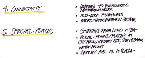
17 movement Pedestrians and Bikes first (cars secondary) Beacon east of Fifth as a Plaza! No Team consensus regarding Beacon Ave. traffic circulation (i.e. one-way versus two-way) Strengthen linkages to surrounding neighbourhoods Establish mid-block alleyways, in particular in an east / west orientation direct pedestrian access to the water Develop a micro-transportation system Establish a more diverse, walkable public realm Beacon Avenue should meander slightly Connect Seventh Street south of Beacon in doing so reconnect MWC to downtown Establish Fifth and Beacon as the Town Centre Re-visit downtown parking requirements Surface parking prohibited in new development, or number of car spaces dramatically reduced Parking Plan urban design CHARRETTE REPORT 15
; Waterfront; MWC (civic precinct) Establish gateways from land and sea one at the east foot of Beacon, the other at the highway.")
 Establish better waterfront linkages thru Landmark Lane and north side of Marina")
.")
18 built form Encourage sustainable design Establish key focal points/places Townhall Plaza (3rd and 4th); Safeway site (mixed use, residential and parking redevelopment); Fifth and Beacon (Centre of Sidney); Waterfront; MWC (civic precinct) Establish gateways from land and sea one at the east foot of Beacon, the other at the highway. Secondary gateway at Bevan and Fifth Variety of building forms Improved streetfront design and uses / weather protection Beacon Wharf Improvements transient moorage, touch the water Potential for Marina Expansion floating breakwater off of north side of Seaport site (remove existing rock breakwater) Establish better waterfront linkages thru Landmark Lane and north side of Marina Court Waterfront plaza at the east foot of Beacon Avenue Green the streets more trees and small internal plazas Re-consider 4-storey maximum height consider 6-8 stories near the center of downtown, in particular the north side of street (Variety of building heights to create overall Town form). Building height should terrace on south side of Beacon and reduce as they approach the water Massing Model 16 urban design CHARRETTE REPORT


19 Civic Plaza Concept Plan Section Plan Through Beacon Avenue urban design CHARRETTE REPORT 17

20 4.3 team 3: blue team The Blue Team s concept supported mixed-uses in downtown while contemplating urban design and public realm improvements to create a more pedestrian-friendly environment. The greening of downtown with additional open space in the form of small pocket parks, linear parks and greenways/woonerfs was a key idea. Team 3 Concept Plan 18 urban design CHARRETTE REPORT


21 land use Conceptual Infill Development in front of Safeway Extend mixed use commercial/residential pedestrian-oriented development west of Fifth Street to highway Promote mixed use in downtown More public open space in the form of small pocket parks, linear parks and greenways/woonerfs through blocks to form linkages Public plaza at corner of Third and Beacon: buildings pushed back from intersection and set at angle to intersection, streets still open to vehicles but pedestrians given priority, different surface treatments and landscaping Town hall to be moved into new mixed use building onto northwest corner of new public plaza at corner of Third and Beacon. Limit surface vehicle parking to behind, within, and beneath buildings Concept of lane houses used in centres of blocks. Houses would be multifamily 2-3 storey townhouses, some narrow, with parking within and/or partly underground. Houses would be accessed by woonerf-style lanes through blocks Waterfront mixed discussion of more uses off Beacon Wharf. Uses to include more interaction with the water itself, and activities that appeal to all ages, especially youth Move emergency services out of downtown to skateboard park area Safeway parking lot: infill with small retail on the street face, lane houses (narrow townhouses) behind, and mixed use buildings that face into Safeway in order to make area active and have no blank facades or buildings turning their backs on others (i.e. keep parking lot safe by having building faces address each part of it Conceptual Infill Development in front of Safeway urban design CHARRETTE REPORT 19

22 movement Beacon Avenue traffic: All but two team members were in favour of one lane, one way system east of Fifth Street. Two team members were in favour of two way, with one lane each way. Bevan to be enhanced with landscaping, street trees, roundabout at intersection with Fifth, promoted as return route to Highway Beacon to be routed under Pat Bay highway (or stay at grade and highway goes over). New highway exit/interchange created at Ocean Avenue, with access to downtown on Eighth St and Fifth St. Pedestrian linkages forming perpendicular and parallel routes through all blocks of downtown, to provide interesting alternate pedestrian routes through town. Some would be accessible to vehicles, to give access to parking areas. Pedestrian linkages would widen out into small pocket parks in areas. Three structured parking buildings: third or fourth and Beacon, Mary Winspear, somewhere close to waterfront. Buildings to have parking in centre, about 4 storeys, surrounded with retail/office/residential uses on street sides. Residential uses on rooftop, similar to two-storey townhouses, with greenspace/ rooftop patios and gardens. Beacon Avenue 20 urban design CHARRETTE REPORT

 Greatly increased amount of landscaping and street trees in downtown, particularly along pedestrian")
23 built form Height scattered around town as occasional tall buildings. Height was introduced to concept in order to raise it as a discussion point Height on Beacon mostly between 2-4 storeys, with lower buildings on south side and higher buildings on north side Pedestrian-oriented facades Upper storeys of buildings set back to allow sunlight (*some debate on setting upper floors back vs. keeping them straight up to define the street and allow for interaction with street from balconies) Greatly increased amount of landscaping and street trees in downtown, particularly along pedestrian linkages Low level lighting along pedestrian walkways and downtown streets in general, with more hi-tech designs to prevent light overspill into residential windows Not discussed: signage Massing Model urban design CHARRETTE REPORT 21
24 22 urban design CHARRETTE REPORT
3.1 Existing Land Use
 3.0 Land Use This strategy has been developed taking into account the position of the Town of Sidney as the economic center of the Saanich Peninsula. It acknowledges existing land use patterns in the downtown
2.1 Location and Size
 2.0 Context 7 2.1 Location and Size The Saanich Penninsula The study area is centrally located within the Town boundaries on the east side of Highway 17, which runs through Sidney in a north-south direction.
Town Center (part of the Comprehensive Plan)
") Town Center (part of the Comprehensive Plan) Mercer Island Town Center Looking North (2014) In 1994, a year-long process culminated in a set of design guidelines and code requirements for the Town Center
Town Center (part of the Comprehensive Plan) Mercer Island Town Center Looking North (2014) In 1994, a year-long process culminated in a set of design guidelines and code requirements for the Town Center
PLAN ELEMENTS WORKSHOP. April 5, 2016
 PLAN ELEMENTS WORKSHOP April 5, 2016 needs more housing. But there is no one-size fits-all solution. Every neighborhood has its own character. In some places, density is not only appropriate it is badly
Policies and Code Intent Sections Related to Town Center
 Policies and Code Intent Sections Related to Town Center The Town Center Vision is scattered throughout the Comprehensive Plan, development code and the 1994 Town Center Plan. What follows are sections
Clairtrell Area Context Plan
 Clairtrell Area Context Plan March 2005 Urban Development Services City Planning Contents 1. Introduction... 4 2. Development Structure... 6 2.1 Streets... 7 2.1.1 Sheppard Avenue and Bayview Avenue...
appendix and street interface guidelines
 appendix five: building and street interface guidelines appendix 5 building and street interface guidelines BOULEVARDS Boulevards are generally characterized by higher levels of traffic movement at higher
DOWNTOWN GEORGETOWN PLANNING STUDY
 DOWNTOWN GEORGETOWN PLANNING STUDY Community Workshop #3 Thursday, May 4, 08 The Planning Partnership OVERVIEW OF STUDY, PROCESS & MILESTONES We are here PURPOSE OF THE STUDY To develop a clear vision
Complete Neighbourhood Guidelines Review Tool
 Complete Neighbourhood Guidelines Review Tool Prepared By: City of Regina Planning Department October 2014 Page 1 of 14 Community Development Review Checklist for Secondary Plans and Concept Plans The
EXISTING COMPREHENSIVE PLAN
 EXISTING COMPREHENSIVE PLAN Town Center Land Use Element: V. LAND USE POLICIES Town Center Mercer Island's business district vision as described in "Your Mercer Island Citizen-Designed Downtown" was an
THE NEIGHBORHOOD TODAY
 THE NEIGHBORHOOD TODAY CORE AREA VISION How are we Good Urbanism A Site s DNA thinking about Elements of great Unique elements urban communities embedded in a place the site and design? ELEMENTS LIKE:
burlington mobility hubs study Downtown Burlington Mobility Hub
 burlington mobility hubs study Downtown Burlington Mobility Hub Draft Precinct Plan Workbook PIC #3, September 7, 2017 downtown mobility hub objectives City staff and their consultants are proposing an
Figure 3-1: Public Realm Plan
 3 Public Realm Figure 3-1: Public Realm Plan 3.1 Public Realm Concept The public realm concept for the Little Mountain site integrates a clear and accessible movement network with public spaces for social
Lehigh Acres Land Development Regulations Community Planning Project
 Lehigh Acres Land Development Regulations Planning Effort Summary In July, 2010 Commissioner Frank Mann invited the Lehigh Acres community to start discussing how to achieve their recently adopted community
Mark-up of the effect of the proposed Bronte Village Growth Area OPA No.18 on the text of section 24, Bronte Village, of the Livable Oakville Plan
 Mark-up of the effect of the proposed Bronte Village Growth Area OPA No.18 on the text of section 24, Bronte Village, of the Livable Oakville Plan Notes: This document is provided for information purposes
Shared Principles and Emerging Plan Directions
 Shared Principles and Emerging Plan Directions Introduction Since the Fairfield Neighbourhood planning process launched in June 2016, we have heard from many residents, businesses, groups and other people
New-Cast Mixed-use Development Proposal King Street West, Newcastle, Ontario
 URBAN DESIGN BRIEF New-Cast Mixed-use Development Proposal King Street West, Newcastle, Ontario TABLE OF CONTENTS: 1.0 Executive Summary 2.0 Creating Vibrant and Sustainable Urban Places: Excerpts from
This Review Is Divided Into Two Phases:
 Semiahmoo Town Centre Review The purpose of this review: To review the Semiahmoo Town Centre Concept Plan, originally approved in 1993, to ensure that this centre will continue to serve the needs of South
W O R K S H O P S U M M A R Y
 W O R K S H O P S U M M A R Y Community Workshop #2: Preliminary Design Strategies October 27, 2007 Upper Market Community Workshop Series and Design Plan Page 1 of 13 INTRODUCTION The Upper Market Community
ELMVALE ACRES SHOPPING CENTRE MASTER PLAN
 ELMVALE ACRES SHOPPING CENTRE MASTER PLAN Contents 1.0 INTRODUCTION... 2 2.0 LOCATION... 2 3.0 EXISTING CONTEXT... 2 4.0 VISION & GUIDING PRINCIPLES... 2 5.0 LAND USE AND BUILT FORM... 4 5.1 St. Laurent
Plan Framework Report. Attachment A
 Plan Framework Report Attachment A Uptown-Douglas Corridor Plan - Plan Framework Report Contents Introduction... 1 Planning Process... 3 Project Objectives... 4 Vision... 5 Community Values... 6 Structural
Town of Sidney. Downtown / Downtown Waterfront. A Blueprint for Building a Complete Community. Schedule A
 Town of Sidney Downtown / Downtown Waterfront Loc al Area Plan A Blueprint for Building a Complete Community Schedule A Consolidated for Convenience March 27, 2017 Acknowledgements The Town of Sidney Downtown
West Ocala Vision & Community Plan City Council Work Session. Presented by West Ocala Community Plan Steering Committee
 West Ocala Vision & Community Plan City Council Work Session Presented by West Ocala Community Plan Steering Committee November 29,2011 Ocala 2035 Vision West Ocala Community Vision & Master Plan West
4- PA - LD - LIVELY DOWNTOWN. LD - Background
 4- PA - LD - LIVELY DOWNTOWN LD - Background The downtown has been the service centre for the community since the city s inception and the area continues to supply people with their personal services,
Prosperity Hucks Area Plan. Transportation and Planning Committee May 11, 2015
 Prosperity Hucks Area Plan Transportation and Planning Committee May 11, 2015 Presentation Outline 1. Background and Location 2. Community Dialog Process 3. Activity Center Recommendations 4. Wedge Recommendations
Westwind Developments Ltd. PIONEER LANDS AREA STRUCTURE PLAN - PROPOSED AMENDMENT
 FEBRUARY 2013 TABLE OF CONTENTS 1.0 BACKGROUND... 1 1.1 Amendment... 1 2.0 LOCATION & CONTEXT... 2 2.1 Land Ownership... 2 3.0 POLICY CONTEXT... 3 3.1 Municipal Development Plan... 3 3.2 Capital Region
Planning Board Briefing
 Planning Board Briefing Why Now? The Sector Plan Implementation Chapter States: Before Stage 1 begins, the following must occur: Approval of the Sectional Map Amendment. Approval of the Greater Lyttonsville
TSAWWASSEN TOWN CENTRE REDEVELOPMENT BLOCK A 004
 Current Context The context for the project includes storey multi-family residential to the northwest, a TD bank immediately north, highway oriented commercial to the east, a surface parking lot to the
Workshop 3. City of Burlington Waterfront Hotel Planning Study. September 14, The Planning Partnership
 Workshop 3 City of Burlington Waterfront Hotel Planning Study September 14, 2017 The Planning Partnership The Waterfront Hotel Planning Study 01 The Brant & Lakeshore Planning Study will establish a Strategic
[PLANNING RATIONALE] For Site Plan Control and Lifting of Holding Zone By-Law 101 Champagne Avenue. May 23, 2014
![[PLANNING RATIONALE] For Site Plan Control and Lifting of Holding Zone By-Law 101 Champagne Avenue. May 23, 2014](/thumbs/75/71599615.jpg "[PLANNING RATIONALE] For Site Plan Control and Lifting of Holding Zone By-Law 101 Champagne Avenue. May 23, 2014") [PLANNING RATIONALE] For Site Plan Control and Lifting of Holding Zone By-Law 101 Champagne Avenue May 23, 2014 Contents 1.0 Introduction... 2 2.0 Site Context... 2 2.1 Adjacent Uses... 2 Figure 1: Site
[PLANNING RATIONALE] For Site Plan Control and Lifting of Holding Zone By-Law 101 Champagne Avenue May 23, 2014 Contents 1.0 Introduction... 2 2.0 Site Context... 2 2.1 Adjacent Uses... 2 Figure 1: Site
Public Consultation Summary: Lakeview Place Making Workshop January 30, 2008.
 Page 1 of 11 Public Consultation Summary: Lakeview Place Making Workshop January 30, 2008. 1.0 Introduction: On January 30, 2008 the City of Mississauga, in conjunction with the consulting team of Brook
8. Urban Villages. Other Relevant Policies & Bylaws Official Community Plan Development Permit Area Designations and Guidelines
 8. Urban Villages Urban villages provide walkable shops and services, encourage a neighbourhood social life, create a sense of place and provide different housing options. More housing near Urban Villages
DRAFT Land Use Chapter
 Stevens Creek Urban Village DRAFT 1 18 17 Land Use Chapter INTRODUCTION This Land Use Chapter describes how the Stevens Creek Urban Village will accommodate the growth that is planned for it in the Envision
Hamilton Pier 7&8 Draft Urban Design Plan
 Hamilton Pier 7&8 Draft Urban Design Plan Public Open House October 29, 2015 Contents 1. Study Overview 2. Area Design Goals 3. Urban Structure 4. Public Realm 5. Urban Design Plan Options 6. Next Steps
7Page 91 CLEMMONS COMMUNITY COMPASS 7 COMMUNITY CHARACTER
 7 Community Character The beauty of Clemmons won t necessarily be a reflection of our past, but our future. This quote from Comprehensive Plan Steering Committee member Wayne Dodson captures the essence
City of Farmington. Downtown Plan. Amendment to the 1998 Master Plan Adopted October 11, 2004
 City of Farmington Amendment to the 1998 Master Plan Adopted October 11, 2004 Introduction Planning Background 1 Scope and Components of the Plan Amendment 2 Concept Introduction 3 Plan Concepts 3 Conceptual
Welcome. Walk Around. Talk to Us. Write Down Your Comments
 Welcome This is an information meeting introducing the applications for proposed redevelopment of the Yorkdale Shopping Centre site at 3401 Dufferin Street and 1 Yorkdale Road over the next 20+ years,
Burnside Gorge Neighbourhood Plan. Engagement Summary
 Burnside Gorge Neighbourhood Plan Engagement Summary Table of Contents Engagement Summary... 3 Phase One Engagement (April May 2015)... 4 Phase Two Engagement (January March 2016)... 4 Appendix One: Summary
Bourne Downtown Site Planning
 Prepared for: The Town of Bourne, MA In Cooperation with: Bourne Financial Development Corporation Prepared by:, Inc. June 24, 2009 Table of Contents Introduction and Summary... 1 Site Existing Conditions...
Stadium District Masterplan
 Stadium District Masterplan Masterplan (noun): an evolving long-term planning document that establishes the framework and key elements of a site. It reflects a clear vision synthesizing developer goals
What We Heard. Downtown Georgetown Planning Study. Consultation Event #3 May 24, 2018
 What We Heard Downtown Georgetown Planning Study Consultation Event #3 May 4, 08 Workshop - July 5, 07 0 WORKSHOP The Downtown Georgetown Planning Study will guide growth and development in the downtown
1.0 Purpose of a Secondary Plan for the Masonville Transit Village
 Report to Planning and Environment Committee To: Chair and Members Planning & Environment Committee From: John M. Fleming Managing Director, Planning and City Planner Subject: Masonville Transit Village
W O R K S H O P S U M M A R Y. Community Workshop #1: Visioning September 11th, 2007
 W O R K S H O P S U M M A R Y Community Workshop #1: Visioning September 11th, 2007 Upper Market Community Workshop Series and Design Plan Page 1 of 9 INTRODUCTION The Upper Market Community Workshop Series
hermitage town center
 hermitage town center A Community Vision prepared by Strada for The City of Hermitage and The Mercer County Regional Planning Commission January 2007 table of contents introduction 3 design principles
HIGHLAND VILLAGE GREEN URBAN DESIGN PRINCIPLES/GUIDELINES
 URBAN DESIGN GUIDING PRINCIPLES/GUIDELINES CONTEXT/CHARACTER The City of Calgary s Municipal Development Plan (MDP), Transit-Oriented Development (TOD) Policy Guidelines and Main Street/Corridor policy
ARLINGTON COUNTY, VIRGINIA
 ARLINGTON COUNTY, VIRGINIA County Board Agenda Item Meeting October 15, 2005 DATE: September 28, 2005 SUBJECT: Request to Advertise the adoption of the 2005 Clarendon Sector Plan C. M. RECOMMENDATION:
Status Update (2006 vs. Now) Citizen s Advisory Committee February Plan for Prosperity
 Citizen s Advisory Committee February Plan for Prosperity") Status Update (2006 vs. Now) Citizen s Advisory Committee February 2018 Plan for Prosperity 2000 2017 2000 2017 Gardnerville Population 6,000 5,760 5746 5,500 5,000 5,067 5,550 5,165 5,394 5,412 5,250
Status Update (2006 vs. Now) Citizen s Advisory Committee February 2018 Plan for Prosperity 2000 2017 2000 2017 Gardnerville Population 6,000 5,760 5746 5,500 5,000 5,067 5,550 5,165 5,394 5,412 5,250
Lower South Street/Louisa Street Charrette Final Presentation. September 22, 2009
 Lower South Street/Louisa Street Charrette Final Presentation September 22, 2009 Recap Mayor and Council called for a Charrette to engage the public on creating a vision for the Lower South Street area.
McCowan Precinct Plan Study Background & Deliverables
 1 DRAFT & WITHOUT PREJUDICE McCowan Precinct Plan Study Background & Deliverables In September, 2011, City Planning (Scarborough District) began a study of an area within the Scarborough Centre, identified
Highland Village Green Design Guidelines
 Highland Village Green Design Guidelines Publishing Information Title Highland Village Green Design Guidelins Author The City of Calgary Status DRAFT - Proposed document subject to changes Additional Copies
Metro. Activity Center Design Guidelines. Recommendations For Developing Focused, Mixed-Use Commercial/Residential Centers
 Metro Activity Center Design Guidelines Recommendations For Developing Focused, Mixed-Use Commercial/Residential Centers Metro Activity Centers What is a MAC? Legacy, the adopted guide for the future growth
What We Heard. Downtown Georgetown Planning Study. April 4, 2018
 What We Heard Downtown Georgetown Planning Study April 4, 2018 Workshop 2 - July 5, 2017 01 DESIGN SUMMIT The Downtown Georgetown Planning Study will guide growth and development in the downtown over the
5.1 Site Plan Guidelines
 5. Community Core Guidelines Development of the Community Core will take place by plan of subdivision and site plan approval. It will occur in a phased manner that will reflect the timing of residential
Official Community Plan Bylaw No. 4360, 2004, Amendment Bylaw No. 4897, 2016 (Sewell s Landing)
") District of West Vancouver Official Community Plan Bylaw No. 4360, 2004, Amendment Bylaw No. 4897, 2016 (Sewell s Landing) Effective Date: 1089612v1 District of West Vancouver Official Community Plan Bylaw
District of West Vancouver Official Community Plan Bylaw No. 4360, 2004, Amendment Bylaw No. 4897, 2016 (Sewell s Landing) Effective Date: 1089612v1 District of West Vancouver Official Community Plan Bylaw
Regency Developments. Urban Design Brief. Holyrood DC2 Rezoning
 Regency Developments Urban Design Brief Holyrood DC2 Rezoning Stantec Consulting Ltd. 7-31-2017 1. Overview Regency Developments intends to rezone the lands located at 8510 and 8511 93 Avenue, within the
LAKEVIEW VILLAGE VISION & MASTERPLAN PRESENTATION TO CITY OF MISSISSAUGA. April 9, 2018
 LAKEVIEW VILLAGE VISION & MASTERPLAN PRESENTATION TO CITY OF MISSISSAUGA April 9, 2018 AGENDA Introduction Vision Plan Comparison The Big Moves Trail Connections Plan Overview Districts Conveyance Comparison
Concept Evaluations 2 May 2009
 Concept Evaluations 2 May 2009 Evaluation Purpose The purpose of this evaluation is to gain feedback from the CRC and community on the ideas presented within the concepts and how the concepts relate to
PINE CURVE REZONING. BACKGROUND Purchased as two parcels in 2001 and 2002
 BACKGROUND Purchased as two parcels in 2001 and 2002 WHAT THE PROJECT IS AND IS NOT A Rezoning establishes the land use standards for Annexed and Zoned Greater Downtown District Historic Center September
PUBLIC RIGHT-OF-WAY IN THIS CHAPTER PUBLIC REALM
 PUBLIC RIGHT-OF-WAY This section provides design guidelines for improvements in the public right-of-way. The public right-of-way refers to streets, sidewalks, non-vehicular thoroughfares, parks and greenways
Ivywild On The Creek PRELIMINARY CREEK DISTRICT MASTER PLAN
 Ivywild On The Creek PRELIMINARY CREEK DISTRICT MASTER PLAN Introduction: Rejuvenating an extraordinary Creekside neighborhood THE CREEKSIDE DISTRICT The Ivywild On The Creek Neighborhood District Master
Status Report: MD 355 Project
 Status Report: MD 355 Project OCTOBER 2006 M-NCPPC MONTGOMERY COUNTY PLANNING DEPARTMENT Summary of Community Comments, and break to the Results of the MD 355 Participation Session Brookside Gardens -
City of Long Beach. creating vibrant and exciting places
 City of Long Beach creating vibrant and exciting places Land Use Element Urban Design Element Overview of the two draft General Plan elements Discuss areas of change Economic goals of the plans Case study
DRAFT Northeast Quadrant of Kipling Avenue and Highway 7 DRAFT AUGUST 29, Goals Land Use. The goals of this Plan are to:
 AUGUST 29, 2017 12.15 Northeast Quadrant of Kipling Avenue and Highway 7 12.15.1 Goals 12.15.2 Land Use The goals of this Plan are to: 12.15.2.1 General Provisions: a) Ensure the development of a compact
BROOKLYN PARK / 85TH AVE LRT STATION CDI DEVELOPMENT GUIDELINES DRAFT
 August 2018 Page intentionally left blank The Brooklyn Park Library adjacent to the 85th Ave LRT Station Area. OVERVIEW The Blue Line LRT Extension / Bottineau corridor offers a unique opportunity to leverage
1 Welcome! UBC Okanagan Master Plan Update - Open House
 1 Welcome! UBC Okanagan Master Plan Update - Open House UBC is updating the Master Plan for the Okanagan Campus. The purpose of today s Open House is to: Present the draft 2015 Master Plan Answer any questions
INSTITUTIONAL USE DESIGN COMPATIBILITY TECHNIQUES
 INSTITUTIONAL USE DESIGN COMPATIBILITY TECHNIQUES INTRODUCTION Community institutions are an important part of the character and vitality of neighborhoods in Forsyth County. Institutional uses include
Subarea 4 Indian Creek. Vision The combination of park networks and transportation amenities make Subarea 4 the greenest hub in the Corridor.
 indian creek 180 extends south from 101st Street to I-435. The I-435 and Metcalf intersection is one of the primary intersections in the Kansas City Metro Area. The area includes several residential neighborhoods
DALY CITY VISIONING PROCESS COMMUNITY WORKSHOP 3 MAY 8, 2008
 DALY CITY VISIONING PROCESS COMMUNITY WORKSHOP 3 MAY 8, 2008 PROCESS General Plan - a statement of the community s values, vision and aspirations for now and into the future... Timeframe LONG TERM - 2030
SECTION TWO: Overall Design Guidelines
 SECTION TWO: Overall Design Guidelines This section provides overall design principles and guidelines for the Gardnerville Mixed-use Overlay. They provide criteria for mixed-use places consisting of residential,
Table of Contents. Elm Avenue Improvement Plan City of Waco, Texas. Introduction 1. Existing Context 1 Figure 1 2.
 Table of Contents Introduction 1 Existing Context 1 Figure 1 2 Plan Guidelines 3 Future Urban Form 4 The West-End 4 Main Street 6 The East-End 7 Figure 2 9 Public Improvement Recommendations 7 General
DRAFT. October Wheaton. Design Guidelines
 October 2011 DRAFT Wheaton Design Guidelines 2 Draft - Design Guidelines - Wheaton Sector Plan Contents 04 Section 1: Introduction 06 Section 2: Context 08 Section 3: Design Guidelines 09 Goal 1: Create
Public Open House. Yonge Street and Bernard Avenue (Bernard KDA) Planning Study Update Town of Richmond Hill. March 30, 2017
 Planning Study Update Town of Richmond Hill. March 30, 2017") Public Open House Yonge Street and Bernard Avenue (Bernard KDA) Planning Study Update Town of Richmond Hill March 30, 2017 Open House Review of Project Purpose and Process Policy Refresher Highlights of
Public Open House Yonge Street and Bernard Avenue (Bernard KDA) Planning Study Update Town of Richmond Hill March 30, 2017 Open House Review of Project Purpose and Process Policy Refresher Highlights of
Sheridan Boulevard S TAT I O N A R E A P L A N S H E R I D A N B O U L E VA R D S TAT I O N A R E A P L A N
 Sheridan Boulevard S TAT I O N A R E A P L A N 1 City of Lakewood Adopted November, 2006 S H E R I D A N B O U L E VA R D S TAT I O N A R E A P L A N The Vision The City of Lakewood s overall vision is
URBAN DESIGN BRIEF URBAN DESIGN BRIEF 721 FRANKLIN BLVD, CAMBRIDGE August 2018
 URBAN DESIGN BRIEF URBAN DESIGN BRIEF 721 FRANKLIN BLVD, CAMBRIDGE August 2018 DESIGN BRIEF CONTENTS PART A 1.0 INTRODUCTION 2.0 DESCRIPTION & ANALYSIS OF SITE CONTEXT 3.0 DESIGN CONSTRAINTS AND OPPORTUNITIES
6. DOWNTOWN. The Downtown Element focuses on supporting and expanding the vitality and enhancement of Downtown Chico as the City s central core.
 VISION In 2030, Downtown Chico is the heart of the community and the center of cultural activity. Engaging and active at the street level, it is a multi-story, mixed-use hub, with specialty retail, restaurants,
Courtice Main Street Study Community Vision Workshop PLANNING SERVICES DEPARTMENT
 Courtice Main Street Study Community Vision Workshop PLANNING SERVICES DEPARTMENT July 22, 2009 Tonight s Meeting 7:00 pm Introduction David Crome, Director of Planning 7:05 Presentation Stasia Bogdan,
Carlsbad Village Redevelopment Concept Summary of Features
 Carlsbad Village Redevelopment Concept Summary of Features Calthorpe Associates November 5, 2003 The Redevelopment Concept illustrates a vision for the future of Carlsbad Village. The overall vision of
PUBLIC PARKS AND FACILITIES, SERVING NEIGHBORHOOD RECREATIONAL AND COMMUNITY EVENTS BUILDINGS BUILT TO THE LINE AND ORIENTED TOWARD THE STREET
 BUILDINGS BUILT TO THE LINE AND ORIENTED TOWARD THE STREET PUBLIC PARKS AND FACILITIES, SERVING NEIGHBORHOOD RECREATIONAL AND COMMUNITY EVENTS CONNECTED & COMPLETE STREETS AND STREET GRID VIEW SHEDS GROUND
GO Station Mobility Hubs: Draft Precinct Plans. Committee of the Whole July 12, 2018
 GO Station Mobility Hubs: Draft Precinct Plans Committee of the Whole July 12, 2018 Purpose of this Workshop Present Draft Precinct Plans for the 3 GO Station Mobility Hubs Continue the conversations that
Lower Merion Commercial Districts Issues and Characteristics Handbook November 2013
 Lower Merion Commercial Districts Issues and Characteristics Handbook November 2013 DRAFT TOWNSHIP-WIDE VISION: To maintain and enhance commercial areas to complement the surrounding high-quality residential
Civic Center District
 Civic Center District The Civic Center district is the civic and social heart of Warrenville, containing such public buildings as the City Hall, Warrenville Public Library, Police Station, Park District
Allen Street Civic District Redevelopment Area Plan Redevelopment Plan & Proposal State College Planning Commission State College Redevelopment
 Allen Street Civic District Redevelopment Area Plan Redevelopment Plan & Proposal State College Planning Commission State College Redevelopment Authority September 17, 2015 Discussion Points Overview of
Project Profile BAR HARBOR
 1 BAR HARBOR The Bar Harbor Master Plan merges community vision with design guidelines to preserve the unique character of Bar Harbor Village. PROJECT SUMMARY Overview: The economic vitality of Bar Harbor
The Master Plan Framework
 The Master Plan Framework The East Harbour Master Plan advances the development of 60 acres of former industrial lands east of the Don River. The Master Plan outlines a vision for a vibrant, transit-oriented
C I T Y O F T O R O N T O L A W R E N C E A V E N U E E A S T S T U D Y. Northwest Corner of Birchmount Road and Lawrence Avenue East
 C I T Y O F T O R O N T O A P P E N D I X A Northwest Corner of Birchmount Road and Lawrence Avenue East 92 DILLON CONSULTING LTD. - J.C. WILLIAMS GROUP LTD. APPENDIX B LAWRENCE AVENUE EAST STUDY SUMMARY
Midtown Greenway Land Use and Development Plan Executive Summary
 Midtown Greenway Land Use and Development Plan Executive Summary Introduction The Midtown Greenway Land Use and Development Plan sets policy direction for land use and development in the Midtown Greenway
SECTION ONE: INTRODUCTION. introduction
 introduction 1 INTRODUCTION Since it was first established in 1843 as a trading post for the Hudson s Bay Company, Victoria has evolved into a Provincial capital city that is recognized across Canada and
Hamilton Pier 7&8 Public Meeting and Workshop #1
 Hamilton Pier 7&8 Public Meeting and Workshop #1 May 12, 2015 May 01, 2015 Meeting Agenda 6:30 Doors Open 6:30-6:45 Review Boards 6:45-7:10 Introductions and Presentation Study Overview Policy Background
4.0 Design Guidelines For The Village Centre. South fields Community Architectural Design Guidelines Town of Caledon
 4.0 Design Guidelines For The Village Centre 4.0 Design Guidelines for the Village Centre The Village Centre is the focal point of the entire South Fields Community and is designed as a traditional commercial
Neighborhood Districts
 NEIGHBORHOOD DISTRICTS SEVEN MAIN DISTRICTS Neighborhood Districts While the Development Plan provides a broad-scale overview of the neighborhood, this section focuses on uses and relationships at the
3.3. Urban Structure Defining a New Hierarchy of Routes and Spaces >Images
 Section 3.0 I The Masterplan Framework 18 >Images Examples of high quality routes and spaces 3.3. Urban Structure The success of any masterplan lies in a clear definition of the future urban structure
Courthouse Square Planning & Urban Design Study. Courthouse Square Working Group #13 October 15, 2014
 Courthouse Square Planning & Urban Design Study Courthouse Square Working Group #13 October 15, 2014 1 Courthouse Square Process Working Group Community Courthouse Square Advisory Groups & Civic Associations
Urban Design Manual PLANNING AROUND RAPID TRANSIT STATIONS (PARTS) Introduction. Station Study Areas
 Introduction. Station Study Areas") 111111 PLANNING AROUND RAPID TRANSIT STATIONS (PARTS) Introduction The ION rapid transit system will link Waterloo, Kitchener and Cambridge through a central transit corridor (CTC). There are a number
111111 PLANNING AROUND RAPID TRANSIT STATIONS (PARTS) Introduction The ION rapid transit system will link Waterloo, Kitchener and Cambridge through a central transit corridor (CTC). There are a number
Tonight s Agenda. Summary Presentation Open House. Group Discussion Next Steps: online community wide survey
 Community Open House February 22, 2018 Tonight s Agenda Summary Presentation Open House Station 1: Project Overview and Community Input Station 2: Draft Vision and Guiding Principles Station 3: Western,
PUBLIC OPEN HOUSE HURONTARIO-MAIN CORRIDOR SECONDARY PLAN
 PUBLIC OPEN HOUSE HURONTARIO-MAIN CORRIDOR SECONDARY PLAN Tuesday, February 28, 2012 6pm 9pm 1 st Floor Atrium, City Hall 2 Wellington Street West, Brampton 1 POLICY FRAMEWORK The 2006 Provincial Growth
A. Selma Park, Davis Bay and Wilson Creek
 A. Selma Park, Davis Bay and Wilson Creek This waterfront neighbourhood consists of three separate community areas, linked by Highway 101, but with different character, land use patterns and future potential.
Animating the Rideau Canal December 2013
 Executive Summary Animating the Rideau Canal December 2013 Why study the Rideau Canal? The Rideau Canal has been an important part of Ottawa throughout its history, and has shaped and been shaped by the
Gold Line Bus Rapid Transit Transit Oriented Development (BRTOD) Helmo Station Area Plan
 Helmo Station Area Plan") Appendix F Gold Line Bus Rapid Transit Transit Oriented Development (BRTOD) Helmo Station Area Plan Introduction and Purpose of the Plan The Gold Line Bus Rapid Transit facility is an eleven-mile dedicated
Appendix F Gold Line Bus Rapid Transit Transit Oriented Development (BRTOD) Helmo Station Area Plan Introduction and Purpose of the Plan The Gold Line Bus Rapid Transit facility is an eleven-mile dedicated
BROADWAY-ARBUTUS POLICIES. Adopted by City Council on July 7, NOTE: To be considered in combination with applicable guidelines
 50 City of Vancouver Land Use and Development Policies and Guidelines Community Services, 453 W. 12th Ave Vancouver, BC V5Y 1V4 F 873.7344 fax 873.7060 planning@city.vancouver.bc.ca BROADWAY-ARBUTUS POLICIES
REPORT BACK BROADSHEET 3 May 2016
 Paddington Place REPORT BACK BROADSHEET May 06 Architects and planners should work with the community first and then thinking about developers profits second. - Quote from participant at Paddington Place