The Study on Implementation of the BMA Subcenter Program in the Kingdom of Thailand
|
|
|
- Alexina Richard
- 5 years ago
- Views:
Transcription
1 / Bangkok Metropolitan Administration The Study on Implementation of the BMA Subcenter Program in the Kingdom of Thailand 1 st December, 2005 Open Seminar (Thai-Japanese Sports Stadium) JICA Study Team
2 Chapter 1 Introduction
3 1.1 Objective of the Study 1) To formulate a strategic development plan for the Lat Krabang area (subcenter area: 2,000ha) 2) To formulate a basic plan for the pilot project area, selected in the Lat Krabang area for the pre-f/s of the land readjustment method 3) To implement the capacity building for the counterparts and Thai officials
 The 2 nd Intl Airport")
4 1.2 Study Area 1) Location Map of the Subcenter Area 30km east far from the center of BKK Close to the 2 nd Int l Airport Central Part of BKK Lat Krabang Area (Subcenter Area) The 2 nd Intl Airport 30km
5 (2) Study Area Approx. 2,000ha (12,500rai) Outer Bangkok Ring Rd. Bangkok Chonburi Rd. Romklao Rd. On-nut Rd.
6 Chapter 2 Functions of Lat Krabang Sub-Center

7 Chapter 3 What is a Sub-Center? JICA Study Team 2.1 Basic Functions of Lat Krabang Sub-Center Serves the essential urban functions to Eastern Bangkok area Thus creates a regional urban / administrative and business center Creates a residential area for expanding suburban population Provides homes to airport-related related industries
8 2.2 Development Targets Serves as the pilot Sub-Center development for shifting to a multi-center city in Bangkok from one- center city of today. Creating a Gateway to New Airport Thus needs a long term and strong commitment for a World Class, High Quality Subcenter.
9 Formation of Value Creation Center for higher value-added added of the Thai Industries Facilitating a UPSTREAM expansion of Thai Industries from Parts/Components and Assembling to Research & Development and Designing (RD&D) Value Added Thailand Today Upstream Now here A: R&D B: Designing C: Parts & Components D: Assembling E: Marketing Downstream F: Branding S1
10 2.3 Images Held by Local Residents A A Survey by the Study Team with the local residents in Sub- Center area (sample: 350 households) reveals their image of development Garden city CBD Historic International Mixed of all above Educational Green Retails
11 2.4 Components of Lat Krabang Sub-Center Research, Development and Design (RDD) City JICA Study Team Create a Sub-center for Eastern Bangkok Accommodates upstream functions of Industries for higher value-added added (RDD( RDD) Provides high-quality residential areas suitable for suburban residence Thai Culture Town Creation of a water-front town following the Thai tradition, and cater to the needs for Day Tourism
12 International framework: Free Trade & Competition National Policy Framework: Value Creation, Destination Thailand BMA Policy: Multi-center Structure, Suburban development, Compact city Research, Development and Design Sub-center core Garden Suburb Value Creation Center Day Tourism International Trade Center SBIA: International Hub Airport & 45 million passengers Lat Krabang Sub-Center
13 Chapter 3 Master Plan
14 3.1 Planning Framework Development Scenarios Low Growth - Without Project Medium Growth Medium-High Growth - With Project High Growth High Growth Population Framework for Lat Krabang Sub-Center (Summary) ,000 30,000 30,000 30, Population 44,000 53,000 57,000 75, ,000 80,000 89, ,000 Employment Framework for Lat Krabang Sub-Center (Summary) Development Scenarios Low Growth - Without Project Medium Growth Medium-High Growth - With Project ,000 3,000 3,000 3, Employment 13,000 19,000 23,000 36, ,000 38,000 50,000 67,000 JICA Study Team , , , , ,000 82, , ,000

15 3.2 Pre-Conditions for Planning (1) Present Land Use Communities formed along On-Nut Road and along Canal Large agricultural and un-used used lands North of Motorway Small scale development s along Rom Klao Rd. JICA Study Team

16 (2) Land Ownership
17 3.3 Development Plan (1) Basic Concept JICA Study Team North of Chonburi Motorway: Primarily low density residential, agricultural and un-used used lands, with large scale land ownership Accommodates Research, Development and Design (RD&D)City and suburban residential development South of Chonburi Motorway: Major east-west canal and two major temples, relatively established communities with sporadic farm land and un-used used lands Maintains the canal and water-front communities to form Thai Culture Town

18 (2) Two Components Chon Buri Motorway

19 (3) Overall Structure 1) Road and Canal Network NS-1 EW-1 NS-2 Chon Buri Motorway Prawet Bureerom Canal On Nut Road

20 (3) Overall Structure 2) Zoning Chon Buri Motorway Prawet Bureerom Canal On Nut Road
 Improvement Area (Gray")
21 3.4 Classification of Development Methods (1) Improvement Area : Gray Color (2) New Development Area : Pink Color New Develop- ment Area (Red Color) Improvement Area (Gray Color)
22 3.5 RD&D City Component JICA Study Team (1) Direction of Development Seek for higher value added of Thai industries, and promote the upstream functions such as Research and Development / Designing Main focus on high-tech fields such Automobile, ICT and Medical Industries having close relation to high class logistics and information Need to make FDI-Friendly Friendly investment environment (FDI = Foreign Direct Investment) Seek for introduction of Trade Mart functions Accommodate suburban residential needs with quality Location: North of Chonburi Motorway


23 (2) Development Image Convenient Public Transport Active Business Center Comfortable Urban Environment
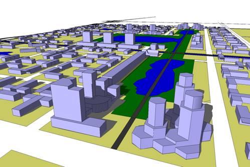
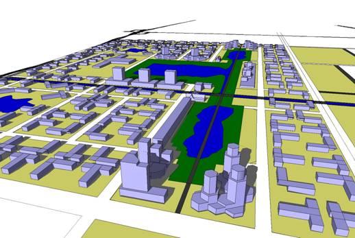
24 (2) Development Image in 3D

25 (3) Zoning for RD&D City JICA Study Team
26 3.6 Culture Town Component (1) Direction of Development Combination of Canal, Temples, Water Market and Water Transport Focus on creation of lively Water Front Area Needs to maintain the traditional Thai water-side towns Cater to the Day-Tourism needs for Airport Passengers (Forecast for Initial Stage 45 million/year) Provide homes to Airport staff and employees at affordable prices Location; South of Chonburi Motorway


27 (2) Development Image Plenty of Tree Lining Cultural Experience Riverside Shopping Walk Revival of Floating Market

28 (3) Zoning of Culture Town JICA Study Team

29 (4) Regional Network of Culture Town Wat Lanboon Temple Wat Sangkaracha Temple Lat Krabang Station King Mongkut Univ. Hua Takae Market Culture Town District Office
30 3.7 Transport Network Plan (1) Public Transport Network Subcenter City Bus Subcenter Feeder Transit System City Bus Shuttle Bus Shuttle Bus SRT Medium Transit System (A) SBIA - SA Rail Link - Red Line (B) SBIA Medium Transit System Subcenter Feeder Transit System City Bus Express Bus Shuttle Bus - Motoway - Krunthep Kritha-Romklao Road Express Bus System (C) SBIA
31 (1) Public Transport Network Necessary Actions; A Comparison of public transport modes needs to be done: Ridership (how many people will ride?) What will be the appropriate type of public transport? (BTS extension/ Light Rail/ Bus transit system etc.) What will be the suitable route? (Connection to Airport Link Railway/ extension to Airport?)

32 (2) Road Network Plan Regional Roads NS1 from On-nut nut to Sukhapiban2 Road EW1 from NS1 to Rom Klao Road NS2 from EW1 to On-nut nut road
33 (2) Road Network Plan Necessary Actions Survey, routing and engineering design of new roads (NS1, EW1 and NS2) Related structures such as bridges, fly-over etc.


34 (3) Improvement of Connection to Motorway New interchange at ORR at New Krungthep Kreeta Road Necessary action: detail design and Land acquisition New Krungphep Kreeta Rd. BORR
35 (4) Inter-modal Facility at Lat Krabang Station Station plaza west side of Rom Klao Road, connected by pedestrian walkway to Lat Krabang Airport Link Station JICA Study Team Subcenter Rom Klao Road Frontage Road Motorway One-way Access Road Motorway Park & Ride Parking (78 cars) Park Lat Krabang St. Station Plaza (7,000 sq.m) Station Plaza Car Pooling Lot Bus Berth Private Car (K&R) Berth Taxi Alighting Berth Taxi Pooling Lot Taxi Bording Berth Park Bus Berth SRT R.O.W LRT Ticket Office LRT Station Toilet Elevator Lat Krabang Station m Airport Rail Link Pedestrian Deck
 3. Retention Ponds (two; 48 ha ea.) 4.")
36 3.8 Flood Protection Plan (1) Adopted Scheme 1. Sub-Polders (two) 2. Canal Improvement (two) 3. Retention Ponds (two; 48 ha ea.) 4. Pumping Stations (two; 2 m3/sec ea.)

37 3.9 Layout of Public Facilities JICA Study Team Neighborhood Unit Neighborhood Unit shall be formed by 10,000 population.

38 Layout of Main Utilities JICA Study Team
39 (2) Outcome of Protection INSIDE the Study Area Canal Improvement with tree lining on the banks Retention ponds to be integrated to urban parks Protected against 5 year flood,, with water level below 0.3 m +MSL OUTSIDE the Study Area The flooding condition would not be worse than the present condition (no( adverse effect)
40 Chapter 4 Strategic Development Plan
41 4.1 Principles for Strategic Planning JICA Study Team What BMA can do now? Development of infrastructure by BMA budget New development (Direct procurement, Land readjustment) Improvement by regulatory control (regulation under urban planning and/or architectural codes) Basic Principles Regional infrastructure by BMA with annual capital budget Ordinary and existing residential communities by improvement by regulatory control Non-residential development by New Development

42 Three New Development Areas
43 4.2 Conditions for Applicability Check of Land Readjustment Regional infrastructure by BMA with separate budget Focus only the primary infrastructure in the Land Readjustment areas Includes only the major road network Excludes land grading (embankment) JICA Study Team Assume land prices before/after the land readjustment following the sub-contracted land price evaluation results
44 (1) Area A: A Lat Krabang Station Area JICA Study Team Area A: Lat Kraang Station Area Case 1: Development only north side of SRT tracks minimum cost scenario
45 Could accommodate Inter Modal function on north side of SRT Motorway Frontage Road One-way Access Road Park & Ride Parking (78 cars) Park Station Plaza (7,000 sq.m) Car Pooling Lot Bus Berth Private Car (K&R) Berth Taxi Alighting Berth Taxi Pooling Lot Taxi Bording Berth Park Bus Berth SRT R.O.W LRT Ticket Office LRT Station Toilet Elevator Lat Krabang Station m Airport Rail Link Pedestrian Deck
46 Area A: Lat Kraang Station Area Case 2: Development north & south sides of SRT tracks maximum benefit scenario
47 Area A: A Major Land Readjustment Indicators Indicator Case 1 Case 2 JICA Study Team Area Public Area 98,900m2 36,500m2 279,800m2 111,200m2 Percentage of Public Area Applicability of land readjustment 36.9% 39.7% Possible some public sector involvement will be necessary such as land procurement/ subsidy for Station Plaza etc.
48 (2) Area B: Soi Wat Lanboon Station Area JICA Study Team Area B: Soi Wat Lanboon Station Area
49 Area B: Major Land Readjustment Indicator Indicator Area Public Area Percentage of Public Area Applicability of land readjustment Value 132,000m2 57,000m2 43.2% (high) Unlikely cooperation between private sector and public sector (BMA) will be crucial. There is uncertainty about the Red Line Station.
50 Area C: RD&D City Area Area C: RD&D City Area Case 1: All Area
51 Area C: Major Land Readjustment Indicators Indicator Area Public Area Percentage of Public Area Applicability of land readjustment Value 4,592,600m2 1,501,400m2 32.7% JICA Study Team Possible with some public sector involvement necessary such as land procurement/ subsidy, but because of many land owners, detailed project planning will be necessary
52 4.3 Pilot Project Zone Area A Area B Area C Total Area 28.0 ha (Case A2) 13.0 ha ha Characteristic High potential for development Convenient location Convenient location Suitable for Land Readjustment Uncertainty of Red Line station Suitable for public and private sector cooperation for development High necessity for core of subcenter Large area / many owners Need long term efforts and phasing
 Chon")

 Rom Klao Road Prawet")
53 Zoning for Pilot Project (Red Line Station - Proposed) Chon Buri Motorway New Access to Subcenter Zone New Access On Nut Road Lat Krabang Station (Airport Link Rail) Rom Klao Road Prawet Bureerom Canal

54 4.4 Strategic Development Plan New Urban Development Public Private Partnership Urban Management by Regulation and Inductive Measures New Development by Land Readjustment Community Development with Focus on Tourism

55 4.5 Development Plan Existing communities
 completed Inter-modal development In progress Water Front")
56 4.5 Development Plan Land Readjustment for Subcenter JICA Study Team Trunk roads (NS1, NS2, EW1) completed Inter-modal development In progress Water Front Improvement
 JICA Study Team Inter-modal development")
57 4.5 Development Plan Value Creation Zone completed Subcenter Urban Development (Phase 1) JICA Study Team Inter-modal development Completed
58 4.5 Development Plan Canal Improvement Subcenter Urban Development (Phase 2) JICA Study Team
 JICA Study Team Inter-modal development In")
59 4.5 Development Plan Canal Improvement Mass Transit in progress Subcenter Urban Development (Phase 3) JICA Study Team Inter-modal development In progress
60 4.5 Development Plan JICA Study Team Mass Transit completed Feeder transport in progress Inter-modal development completed

61 4.5 Development Plan Feeder transport completed JICA Study Team
62 4.6 Institutional Framework Role of Public Sector important in early stage as the overall development initiator Public sector needs to complete infrastructure development in early stage The overall developer role shall be held by BMA under the name of Krungthep Thanakom,, a public company for land development under BMA Important to get involvement of private sector developer for land development subsequently
63 Bangkok Metropolitan Authority (BMA) Krungthep Thanakom Co. Ltd. Government buildings, public facilities World class universities/ research institutions Office park, science park development Retail operator/ S.C. developers Residential developers Residential development Branch campus of world class universities Shopping complex development
64 4.7 Environmental Considerations Environmental / Social Impact / Benefit by Pilot Project Land Readjustment Phase - Minimization of land acquisition impact owing to adoption of land readjustment method - Actualization of orderly development considering living environment Construction Phase - Necessity to consider accumulative impact with relevant construction work Operation Phase - Necessity to consider accumulative impact with Suvarnabhumi Airport
65 Environmental and Social Consideration Survey (pre- EIA level) under JICA Guideline - Assessment of residual impacts which can not avoid by adoption of land readjustment method - Proposal of mitigation measures on negative impact Physical Environment Social Condition Public Service Natural Environment - Land condition, - Air quality, - Water quality, - Noise, - Flooding - Land acquisition, - Local society, - Economic Activity, - Security, - Tourism - Land use, - Transportation, - Water supply, - Waste collection - Terrestrial Ecosystem
66 Thank you very much for your kind attention. JICA Study Team Lat Krabang Project HP Open! Access to 3
THE GARDEN CITY PLAN. City of St. Catharines Official Plan. City of St. Catharines
 THE GARDEN CITY PLAN City of St. Catharines Official Plan City of St. Catharines August 2010 APPROVAL INFORMATION This Official Plan of the City of St. Catharines Planning Area, known as the Garden City
CHAPTER 7: Transportation, Mobility and Circulation
 AGLE AREA COMMUNITY Plan CHAPTER 7 CHAPTER 7: Transportation, Mobility and Circulation Transportation, Mobility and Circulation The purpose of the Transportation, Mobility and Circulation Chapter is to
Inspiring Technovation
 1 2 Table of content List of table and figures... Executive summary... 1. Introduction... 2. Material and methods... 3. Results... 3.1 Today s facts about Versailles: a diagnostic approach... 3.1 Vision
UDF PLANS AND GUIDELINES
 UDF PLANS AND GUIDELINES 5 Land Use Land Use Development Plan Plan no. 3 Land Use Development Mixed Use Retail / Leisure Residential Civic and Institutional Proposed Zoning Table Development Edges Plan
D-O LRT Zoning Discussion. Chapel Hill Boards & Commissions October 16, 2017
 D-O LRT Zoning Discussion Chapel Hill Boards & Commissions October 16, 2017 Update on Overall D-O LRT Station Area Initiative Objectives Design and educate on principles of Good Transit-Oriented Development
Making the case for Sustainable Transport Project Potential
 Making the case for Sustainable Transport Project Potential The Structural Investment Fund (SIF) Strategy for Greater Lincolnshire identifies the barriers to growth identified by having poor transport
Objectives. Target Areas. ESB Development Program (since 1981) Increase competitiveness in the world market. Laem Chabang (Chon Buri Province)
 Increase competitiveness in the world market. Laem Chabang (Chon Buri Province)") ESB Development Program (since 1981) Objectives Target Areas ESB Increase competitiveness in the world market. Open new gateway to connect with int l sea transportation networks. Create new economic /
ESB Development Program (since 1981) Objectives Target Areas ESB Increase competitiveness in the world market. Open new gateway to connect with int l sea transportation networks. Create new economic /
Thailand s Eastern Seaboard Development
 1 Thailand s Eastern Seaboard Development Office of the National Economic and Social Development Board Outline : 2 1 Background 2 Selection of Location 3 Objectives 4 Target Areas 5 Roles of NESDB 6 Impacts
Asset-Based Development Scenario
 Asset-Based Development Scenario The Asset-Based development scenario emphasizes existing regional assets, concentrating future development around these assets. Regional assets include sports arenas, higher
Integrated Multi Modal Public Transit Hub
 Leaders Programme in Urban Transport Planning and Management Integrated Multi Modal Public Transit Hub at Central Business District- Ahmedabad Neela Munshi (Senior Town Planner) Deepa Dave (AM Urban Planner)
This page has been intentionally left blank.
 This page has been intentionally left blank. Chapter 3 3-2 3. Employment 3.A Niagara Economic Gateway 3.A.1 General The Niagara Economic Gateway comprises: a) The Gateway Economic Zone which includes all
Eastern Economic Corridor: An Update
 Eastern Economic Corridor: An Update Dr. Kanit Sangsubhan 22 June 2017 Eastern Seaboard 30 successful years of Area Development Eastern Seaboard (ESB)...Beginning of Thailand s industrialisation The first
Bangkok: Chaos or System? 30 years of urban development and transport planning
 Bangkok: Chaos or System? 30 years of urban development and transport planning H. D. Kammeier, Bangkok This is a selection of 18 slides from an earlier presentation on long-term review of urban development
Energy Efficient Strategies for Urban Transportation Planning
 EinT2018 3 rd International Conference ENERGY in TRANSPORTATION 2018 Energy Efficient Strategies for Urban Transportation Planning Prof. Dr. Doaa M. El-Sherif, PhD, Arch. Email: doaa_elsherif@yahoo.com
TEHRAN LONG TERM URBAN RAIL PLAN
 TEHRAN LONG TERM URBAN RAIL PLAN Introduction and Methodology Introduction Greater Tehran is currently one of the most populated mega cities in the world with an estimated population of 14 million inhabitants
SUSTAINABLE TRANSPORT & INTEGRATED LAND USE PLANNING
 SUSTAINABLE TRANSPORT & INTEGRATED LAND USE PLANNING UNESCAP Capacity Building Workshop, Colombo Integrated Land use and Urban Transport Planning : Principles and Practices 31st October 2017 ACTIVE TRANSPORTATION
PEOPLE S COMMITTEE OF HO CHI MINH CITY DEVELOPMENT STRATEGY FOR HO CHI MINH CITY S INFRASTRUCTURE
 PEOPLE S COMMITTEE OF HO CHI MINH CITY DEVELOPMENT STRATEGY FOR HO CHI MINH CITY S INFRASTRUCTURE Singapore, July 2012 1 GENERAL INFORMATION 2 GENERAL INFORMATION The centre for economics, culture, science
Vision for East Cowes
 Vision for East Cowes A better East Cowes for now and the future The East Cowes Regeneration project is a major regeneration scheme on the Isle of Wight. It will create a vibrant community with a long-term
North Somerset Council Local Development Framework
 North Somerset Council Local Development Framework Sites and Policies Development Plan Document Evidence Paper Re-opening Portishead Railway Line and Options for the Location of Portishead Railway Station
Regional Context Statement
 Regional Context Statement REGIONAL CONTEXT STATEMENT 3. REGIONAL CONTEXT STATEMENT In 1995, the Provincial Government passed into law the Growth Strategies Act. The purpose of this provincial initiative
Field trip report. Field trip transport planning, , 2 ECTS, 2017S
 Field trip report Field trip transport planning, 231.043, 2 ECTS, 2017S Transit-Oriented Development (TOD) initiated by private railway companies in Japan The example of Utsukushigaoka on the Tama Den-en
Executive Summary. NY 7 / NY 2 Corridor
 Executive Summary NY 7 / NY 2 Corridor Transportation and Land Use Study December 2005 Prepared for: Town of Colonie Capital District Transportation Committee Prepared by: Introduction: Land use decisions
RESOLUTION NO. R Refining the route, profile and stations for the Downtown Redmond Link Extension
 RESOLUTION NO. R2018-32 Refining the route, profile and stations for the Downtown Redmond Link Extension MEETING: DATE: TYPE OF ACTION: STAFF CONTACT: Capital Committee Board PROPOSED ACTION 09/13/2018
Downtown Dubuque...it s a great time.
 Downtown Dubuque...it s a great time. Your timing could not be better to invest in Downtown. With hundreds of millions in public and private investment occurring on the City s downtown waterfront, millions
DUBLIN DOCKLANDS MASTER PLAN AND RELATIONSHIP WITH OTHER PLANS
 .1 National Policy and Programmes.1.1 Sustainable Development A Strategy for Ireland, 1997.1.2 National Climate Change Strategy, 2007-2012.1. National Development Plan 2007-201.1.4 National Spatial Strategy,
Atlanta BeltLine Corridor Environmental Study. Scoping Meeting August 2008
 Atlanta BeltLine Corridor Environmental Study Scoping Meeting August 2008 What Will We Be Discussing Today? Study Overview - How Did We Get Here? - What Is the Study About? - Who Is Involved? - Where Is
Riverside South. Rapid Transit Study. Riverside South. Value Planning Workshop
 Riverside South Rapid Transit Study Peter Steacy, P. Eng. Program Manager Transportation Environmental Assessments City of Ottawa Value Planning Workshop Christopher Gordon, P. Eng. Project Manager Transportation
TRANSPORT AND URBAN DEVELOPMENT
 The Study on Urban Transport Master Plan and Feasibility Study in HCM Metropolitan Area (HOUTRANS) TRANSPORT AND URBAN DEVELOPMENT TDSI South & JICA Study Team 1. Objectives and Methodology of Analysis
WELCOME and introduction
 1 WELCOME and introduction Mobility Hub Locations within Burlington STUDY OVERVIEW STUDY OBJECTIVES The City of Burlington is developing four Area Specific Plans, one for each of Burlington s Mobility
WATERLOO STATE SIGNIFICANT PRECINCT SUMMARY OF STUDIES
 WATERLOO STATE SIGNIFICANT PRECINCT SUMMARY OF STUDIES Technical studies will be undertaken to inform the master planning process for the Waterloo precinct to develop a Precinct Proposal to redevelop the
1.4 TRANSIT VISION 2040 FROM VISION TO ACTION THEME 1: PUTTING TRANSIT AT THE CENTRE OF COMMUNITIES. Fully integrate transit with community design
 TRANSIT VISION 2040 FROM VISION TO ACTION TRANSIT VISION 2040 defines a future in which public transit maximizes its contribution to quality of life with benefits that support a vibrant and equitable society,
Gold Line Bus Rapid Transit Transit Oriented Development (BRTOD) Helmo Station Area Plan
 Helmo Station Area Plan") Appendix F Gold Line Bus Rapid Transit Transit Oriented Development (BRTOD) Helmo Station Area Plan Introduction and Purpose of the Plan The Gold Line Bus Rapid Transit facility is an eleven-mile dedicated
Appendix F Gold Line Bus Rapid Transit Transit Oriented Development (BRTOD) Helmo Station Area Plan Introduction and Purpose of the Plan The Gold Line Bus Rapid Transit facility is an eleven-mile dedicated
SUMMARY. An Attractive, Competitive and Sustainable GREATER MONTREAL. Draft Metropolitan Land Use and Development Plan. April 2011
 April 2011 Draft Metropolitan Land Use and Development Plan GREATER MONTREAL An Attractive, Competitive and Sustainable SUMMARY Message from the Chair I am pleased to introduce this draft of the Metropolitan
MONTGOMERY COUNTY METRO STATION AREA DESIGN CHARRETTE
 MONTGOMERY COUNTY METRO STATION AREA DESIGN CHARRETTE Shady Grove Metro Station Area Charrette Closing Presentation October 25-28, 2000 MONTGOMERY COUNTY, MD M-NCPPC Design Collective, Inc. Architects
THE GREEN VISION WORKSHOP Friday, November 6, 2009
 THE GREEN VISION WORKSHOP Friday, November 6, 2009 SUSTAINABLE LONG RANGE PLANNING IN SANTA MONICA Eileen Fogarty Director, Planning and Community Development GREEN BUILDINGS Santa Monica has the most
QUINCE ORCHARD/FIRSTFIELD CORRIDOR CITY OF GAITHERSBURG MTAP 2017
 QUINCE ORCHARD/FIRSTFIELD CORRIDOR CITY OF GAITHERSBURG MTAP 2017 ULI LEADERSHIP INSTITUTE 2017 The Team Allison Davis, WMATA Daniel Park, Rodgers Consulting Debbie Albert, Arlington County Harry Ross,
The University District envisions, in its neighborhood
 Envisioning the University District Link Light Rail in Seattle s neighborhoods CIY OF SEALE CONCEP-LEVEL SAION AREA PLANNING RECOMMENDAION RESOLUION # 30165 EXHIBI L Vision 08.2000 he University District
Appendix A. Planning Processes. Introduction
 1 Planning Processes Introduction This appendix outlines a number of planning processes which are used in the Auckland Region to support the effective management of development in the region s rural and
Integrated Urban Development. April Reflections from the NZPI Study Tour of Portland, Seattle and Vancouver
 Integrated Urban Development April 2009 Reflections from the NZPI Study Tour of Portland, Seattle and Vancouver Integrated Urban Development Urban Growth Management Transportation Transit Orientated Mixed
Silverdale Regional Center
 Silverdale Regional Center Vision for Silverdale Regional Center The Silverdale Regional Center Plan (Plan) will guide the evolution of the Silverdale Regional Center from a collection of strip malls and
Keystone Business Park Precinct Structure Plan North East Industrial Precinct. Part 2 Design Principles
 Keystone Business Park Precinct Structure Plan North East Industrial Precinct Part 2 Design Principles Context Issues Services Landform Issues Geotech and contamination Ecology Traffic and access Issues
SUB AREA 3 CENTRAL STRATFORD AND SOUTHERN QUEEN ELIZABETH OLYMPIC PARK
 191 ADOPTED LOCAL PLAN: THE SUB AREAS SUB AREA 3 CENTRAL STRATFORD AND SOUTHERN QUEEN ELIZABETH OLYMPIC PARK SECTION 12 Vision VISION Central Stratford and Southern Queen Elizabeth Olympic Park will become
TRANSIT ORIENTED DEVELOPMENT
 TRANSIT ORIENTED DEVELOPMENT Dhaka September 13, 2018 Prof. H. M. Shivanand Swamy Centre of Excellence in Urban Transport Why TOD? Economic Increased Density in prime, Convenient Locations Environmental
ORANGE COUNTY IMPLEMENTING THE FOUR C s
 ORANGE COUNTY IMPLEMENTING THE FOUR C s East Central Florida Corridor Task Force O R A N G E COUN TY P LA N N I N G DIVISION C O M M U N I T Y, E N V I R O N M E N T A L A N D D E V E L O P M E N T S E
SCARBOROUGH SUBWAY EXTENSION. Scarborough Subway Extension. Final Terms of Reference
 Scarborough Subway Extension Final Terms of Reference 1 1.0 Introduction and Background 1.1 Introduction Toronto City Council recently confirmed support for an extension of the Bloor-Danforth Subway from
LAND USE OVERVIEW WHAT YOU WILL FIND IN THIS CHAPTER
 LAND USE WHAT YOU WILL FIND IN THIS CHAPTER Information about the City s expected population and employment growth. Description and capacity of existing and future land use designations. Policies that
City Regions Ireland
 City Regions Ireland 01 CITY REGIONS IRELAND COMPRISES OF CORK CHAMBER, DUBLIN CHAMBER, LIMERICK CHAMBER, WATERFORD CHAMBER AND GALWAY CHAMBER, ALL MEMBERS OF CHAMBERS IRELAND. 5 CITIES 8 PRINCIPLES A
BETTER PUBLIC TRANSPORT PROJECT WATERBEACH TO SCIENCE PARK AND EAST CAMBRIDGE CORRIDORS
 Report To: Greater Cambridge Partnership Joint Assembly 20 th September 2018 Lead Officer: Peter Blake GCP Director of Transport BETTER PUBLIC TRANSPORT PROJECT WATERBEACH TO SCIENCE PARK AND EAST CAMBRIDGE
Urban Design Manual PLANNING AROUND RAPID TRANSIT STATIONS (PARTS) Introduction. Station Study Areas
 Introduction. Station Study Areas") 111111 PLANNING AROUND RAPID TRANSIT STATIONS (PARTS) Introduction The ION rapid transit system will link Waterloo, Kitchener and Cambridge through a central transit corridor (CTC). There are a number
111111 PLANNING AROUND RAPID TRANSIT STATIONS (PARTS) Introduction The ION rapid transit system will link Waterloo, Kitchener and Cambridge through a central transit corridor (CTC). There are a number
CHIANG RAI CITY MUNICIPALITY. The Project for Promoting Sustainability in Future Cities of Thailand
 CHIANG RAI CITY MUNICIPALITY The Project for Promoting Sustainability in Future Cities of Thailand Eco-Friendly and resilient Civic pride for future generations SFC CONCEPT Self-sustaining competitive
South Fulton Parkway Transit Feasibility Study
 South Fulton Parkway Transit Feasibility Study Study Purpose To conduct a high level assessment of potential transit improvements in the South Fulton Parkway Corridor through the evaluation of various
Speers Road Corridor Study. Livable Oakville (Official Plan) Council Sub Committee March 20, 2017
 Council Sub Committee March 20, 2017") Speers Road Corridor Study Livable Oakville (Official Plan) Council Sub Committee March 20, 2017 Overview 1) Study Purpose & Background 2) Study Area 3) Policy Context and Plan Review 4) Speers Road Corridor
Speers Road Corridor Study Livable Oakville (Official Plan) Council Sub Committee March 20, 2017 Overview 1) Study Purpose & Background 2) Study Area 3) Policy Context and Plan Review 4) Speers Road Corridor
Strategic Growth Area #1 Northampton Boulevard Corridor Area
 Strategic Growth Area #1 Northampton Boulevard Corridor Area Description Strategic Growth Area #1 has established itself as a major employment center in Southside Hampton Roads. Opportunities exist to
OUR GREATER SYDNEY A metropolis of three cities. OVERVIEW. connecting people. DRAFT Greater Sydney Region Plan
 OUR GREATER SYDNEY 2056. A metropolis of three cities. OVERVIEW. connecting people. DRAFT Greater Sydney Region Plan October 2017 This document is an overview of the draft Greater Sydney Region Plan. To
Tony Garcia, City-County Planning Commission & Beth Alden, Hillsborough MPO
 Tony Garcia, City-County Planning Commission & Beth Alden, Hillsborough MPO TOD Defined A compact neighborhood with housing, jobs and neighborhood services within easy walking distance of a transit station
New Partners for Smart Growth Conference February 5, 2010
 Dan Stroh, Planning Director City of Bellevue Planning and Community Development Bellevue, WA New Partners for Smart Growth Conference February 5, 2010 Summary of Project Long-range plan update for Bel-Red
THE TOWN OF WASAGA BEACH
 THE TOWN OF WASAGA BEACH Downtown Development Master Plan Committee of the Whole Presentation January 26 th 2017 Uses within this designation should reflect a dependence on tourism as opposed to the permanent
Page 1 of 19 URBAN DESIGN FRAMEWORK FOR BOLTON STREET WATERFORD
 Page 1 of 19 URBAN DESIGN FRAMEWORK FOR BOLTON STREET WATERFORD 1.0 Introduction: The relocation of the City Council stores and depot from Bolton Street creates an exciting opportunity for development
Public Open House. Overview of the Downtown Plan Official Plan Amendment April 23, 2018
 Public Open House Overview of the Downtown Plan Official Plan Amendment April 23, 2018 1 A 25-Year Plan for Downtown To ensure growth contributes positively to Toronto s Downtown as a great place to live,
Route 110 Alternatives Analysis
 Route 110 Alternatives Analysis Public Meeting #1 December 15, 2014 Source: Town of Babylon Agenda Welcome/Introduction Hon. Antonio A. Martinez Deputy Supervisor, Town of Babylon Update on East Farmingdale
3. Endorse the LRT vision in transforming Surrey into Connected-Complete-Livable communities, and more specifically, the official vision statement:
 CORPORATE REPORT NO: R038 COUNCIL DATE: February 20, 2017 REGULAR COUNCIL TO: Mayor & Council DATE: February 16, 2017 FROM: General Manager, Engineering FILE: 8740-01 SUBJECT: Surrey Light Rail Transit
Elodie Gonthier (Team leader) Kevin Ramirez Sandra Velasco Krishna Chandran Anna Aghvanyan Sirin Hamsho
 Kevin Ramirez Sandra Velasco Krishna Chandran Anna Aghvanyan Sirin Hamsho") 2 T he nature of today s global economy highlights our interdependence and the need for much better global policies. Inspiring Technovation is pleased to present its report on transforming the city of
2 T he nature of today s global economy highlights our interdependence and the need for much better global policies. Inspiring Technovation is pleased to present its report on transforming the city of
Newcourt Masterplan. November Exeter Local Development Framework
 Newcourt Masterplan November 2010 Exeter Local Development Framework Background The Exeter Core Strategy Proposed Submission sets out the vision, objectives and strategy for the development of Exeter up
MPD 2021 Review TOD Policy
 MPD 2021 Review TOD Policy CURRENT CITY PATTERN: Population Density evenly distributed all over city. Large Travel distances & pollution due to segregated land use and vehicular dependency. Rohtak Road
PILLAR FOUR INTEGRATE LAND USE & TRANSPORTATION
 PILLAR FOUR INTEGRATE LAND USE & TRANSPORTATION 8 Scarborough Centre on the Move Transportation Master Plan 123 8 Transportation Pillar Four Integrate Land Use & The fourth pillar focuses on the relationship
Tianfu Ecological City. Chengdu, China
 Tianfu Ecological City Chengdu, China Tianfu Ecological City Chengdu, China Adrian Smith + Gordon Gill Architecture s master plan for Tianfu Ecological City is the vision for a self-sustaining, environmentally
Submission to the Kildare County Council Development Plan North Kildare Chamber. Executive Summary
 ` 28 th May 2015 Submission to the Kildare County Council Development Plan 2017-2023 North Kildare Chamber Executive Summary North Kildare Chamber s mission is to work with businesses, community groups,
Session 4 New Urban Regions and Major Urban Extensions. Tackling Western Sydney s Urban Growth
 Session 4 New Urban Regions and Major Urban Extensions Tackling Western Sydney s Urban Growth Stephanie Barker Rohan Dickson & Associates and consultant to NSW Growth Centres Commission Friday 8 February
Navan 1. Nevinstown 2. Farganstown 3. Liscarton
 Review of Economic Development Sites and Residential Lands regarding the Proposed Variation No. 3 (Phase 3b) for Meath County Council Navan Review of Economic Development Sites regarding the Proposed Variation
Economy Vision Statements: Social Wellbeing Vision Statements: Natural Environment Vision Statements:
 Economy Vision Statements: 1. Our business environment makes us a region of choice for new employers as we encourage entrepreneurship and have a vibrant, diversified and resilient regional economy. 2.
Principal development issues
 Principal development issues The transformation of the Bonaventure Expressway from Saint- Jacques to Brennan Streets will create a major urban boulevard with lanes located on either side of a string of
Draft Western District Plan
 Powered by TCPDF (www.tcpdf.org) Draft Western District Plan Submission_id: 31440 Date of Lodgment: 15 Dec 2017 Origin of Submission: Online Organisation name: Goodman Property Services Australia Pty Ltd
Outline of Presentation
 LUSAKA CITY COUNCIL 2 nd Annual IGC Cities Conference Making Cities work for growth London School of Economics (LSE) United Kingdom. 28 th 29 th January 2016 Presenter: Alex Mwansa Town Clerk Lusaka City
CITY COUNCIL AGENDA REPORT
 CITY COUNCIL AGENDA REPORT Subject: COUNCIL MOTION LRT ALIGNMENT REMOVAL FROM THE TRANSPORTATION MASTER PLAN On February 10, 2016 Councillor Hughes provided notice in accordance with Section 23 of Procedure
Mariposa Lakes. Planned Community. Project Overview. Stockton, CA
 Planned Community Stockton, CA Project Overview March 2007 Summary of Proposed Community is a master-planned community proposed for development on approximately 3,810 acres in southeast Stockton. In 2004,
Seneca Meadows. Block 4 Locate office, technology, and medical development adjacent to I Screen views of garage structures from I-270.
 Seneca Meadows Seneca Meadows has an industrial park in its southern end and a mixed-use employment area planned for the north end. The district benefits from extensive I-270 visibility, stream valley
Journeys and destinations.managing Mobility in Europe. EU Cohesion Policy
 Journeys and destinations.managing Mobility in Europe EU Cohesion Policy 2014 2020 Final Conference of PIMMS-Capital INTERREG IVC Cohesion Policy The attraction of mobility Mobility is in our genes In
IMPLEMENTING SOMERSET COUNTY S INVESTMENT FRAMEWORK
 IMPLEMENTING SOMERSET COUNTY S INVESTMENT FRAMEWORK SMART CONSERVATION THROUGH SMART GROWTH NJ LAND CONSERVATION RALLY March 22, 2014 Laurette Kratina, PP, AICP, Supervising Planner Somerset County Planning
NASSAU COUNTY TOWN HALL NEW YORK & CONNECTICUT SUSTAINABLE COMMUNITIES. A Unique Bi-State Partnership to Improve Jobs, Housing and Transportation
 NASSAU COUNTY TOWN HALL NEW YORK & CONNECTICUT SUSTAINABLE COMMUNITIES A Unique Bi-State Partnership to Improve Jobs, Housing and Transportation Police Headquarters Auditorium Mineola, NY December 9 th,
TRANSPORTATION ELEMENT GOALS, OBJECTIVES, AND POLICIES
 TRANSPORTATION ELEMENT GOALS, OBJECTIVES, AND POLICIES GOAL 2 The City shall provide a safe, convenient, effective, and energy efficient multimodal transportation system which is coordinated with the Future
Mini Technical Assistance Panel. Rock Spring Park
 Mini Technical Assistance Panel Rock Spring Park May 22, 2013 The Team Jason Bonnet, Forest City Washington Matthew Flis, Town of Vienna William Herbig, National Capital Planning Commission Sophie Lambert,
TOD Planning in China: Problems and Solutions. Yin Jia, Founder, EFC Engeering Consulting Co. Ltd.
 TOD Planning in China: Problems and Solutions Yin Jia, Founder, EFC Engeering Consulting Co. Ltd. Contents 1. Concept and Origin of TOD 2. Comparison of TOD Development between China and U.S. 3. Practice
Official Plan Review
 Official Plan Review Summary Report - The Built Environment August 2014 Part 1: Introduction Planning for a healthy, prosperous and sustainable community is an important goal for our municipality. From
Edmonton s Transit Oriented Development Journey
 Edmonton s Transit Oriented Development Journey Auckland Design Office Lunchtime Learning July 2018 Tom Young, MCIP, MCP NZ Group Manager, Urban Planning & Environmental Services tom.young@stantec.com
Stratford Neighbourhood Plan Questionnaire
 Stratford Neighbourhood Plan Questionnaire Please tick the appropriate box or answer in the space provided. If you require further copies of the questionnaire, as more than one person in the household
S A C R A M E N T O C O U N T Y JACKSON HIGHWAY & GRANT LINE EAST VISIONING STUDY
 JACKSON HIGHWAY & GRANT LINE EAST S A C R A M E N T O C O U N T Y P L A N N I N G D E P A R T M E N T SUMMARY AND WORKBOOK November 19, 2008 History of the Visioning Study Sacramento County has two growth
Euston Area Plan - Examination: Statement in response to the Inspector s Matters, Issues and Questions
 1 Euston Area Plan - Examination: Statement in response to the Inspector s Matters, Issues and Questions Sydney and London Properties Limited June 2014 2 3 This document is the Statement in response to
Key Themes and Responses May 2016
 King and Victoria Transit Hub and Waterloo Street Pedestrian Access Key Themes and Responses May 2016 The following summarizes what Regional staff heard about the King Victoria Transit Hub and Waterloo
Articulating planning, urban design and mobility policy
 Articulating planning, urban design and mobility policy 1 29 Km Presentation of the Greater Nantes - competences Inter-municipal cooperation body and urban transport organising authority created in 2001
HS2 Interchange Station Design
 Working on behalf of HS2 Interchange Station Design October 2018 www.hs2.org.uk 1 Interchange Station, Solihull Introduction In February 2018, HS2 Ltd appointed Arup to take forward the design of Interchange
Tysons Circulator Study: Process and Preliminary Results Summary. March 2012
 Tysons Circulator Study: Process and Preliminary Results Summary March 2012 Background: 1. The Comprehensive Plan for the Tysons Corner Urban Center calls for a System of Circulators in Tysons Corner to:
Growth Management Planning in the Central Puget Sound Region. Today s Presentation. Puget Sound Region. New Partners for Smart Growth
 Growth Management Planning in the Central Puget Sound Region New Partners for Smart Growth Denver, CO January 2006 Today s Presentation Regional growth management in central Puget Sound, WA Regional geographies
One Bangkok, Thailand s largest integrated development, set to transform Bangkok city-centre and become a new global landmark destination
 For Immediate Release 3 April 2017 (edited 2 May 2018) One Bangkok, Thailand s largest integrated development, set to transform Bangkok city-centre and become a new global landmark destination TCC Group
Plano Tomorrow Vision and Policies
 Plano Tomorrow Vision and Policies PLANO TOMORROW PILLARS The Built Environment The Social Environment The Natural Environment The Economic Environment Land Use and Urban Design Transportation Housing
University of the District of Columbia Van Ness Campus Master Plan Community Open House 3. December 8, 2010
 University of the District of Columbia Van Ness Campus Master Plan Open House 3 December 8, 2010 Introductions Sequence of Work: Campus Master Plan BEGIN: INTRODUCE AND START WORK Project Initiation Team
City of Woodinville Planning Commission Study Session. Development Regulations 101: An Overview of Specific Regulatory Items To Help You in 2012
 City of Woodinville Planning Commission Study Session Development Regulations 101: An Overview of Specific Regulatory Items To Help You in 2012 Development Regulations 101 Overview of the Different Zones
Heart of the Triad A Dynamic Plan for the Future. Steering and Technical Meeting April 27, 2006
 Heart of the Triad A Dynamic Plan for the Future Steering and Technical Meeting April 27, 2006 The Week in Review Specific Group Findings There Was Uniform Agreement the Time Was Right Growth is Imminent
The Proposed Auckland Unitary Plan (notified 30 September 2013)
") 3 Business zones Introduction There are 10 business zones in the Unitary Plan: City Centre Metropolitan Centre Town Centre Local Centre Neighbourhood Centre Mixed Use General Business Business Park Light
3 Business zones Introduction There are 10 business zones in the Unitary Plan: City Centre Metropolitan Centre Town Centre Local Centre Neighbourhood Centre Mixed Use General Business Business Park Light
Blueprint Denver A BLUEPRINT FOR AN INCLUSIVE CITY. Executive Summary
 Blueprint Denver A BLUEPRINT FOR AN INCLUSIVE CITY Executive Summary PUBLIC REVIEW DRAFT 2 1/7/2019 DENVERIGHT BLUEPRINTDENVER Blueprint Denver: A Blueprint for an Inclusive City An Equitable City Planning
EMTA regularly contributes to the European Commission consultation exercises, and takes opportunities to voice its concerns to European Institutions
 EMTA was created in 1998 at the initiative of the STIF, as a forum for the exchange of information research and experience between the public transport authorities responsible for planning, integrating