Integrating Transportation Planning with Land Use and Conservation Through Decision Support Tools
|
|
|
- Berenice West
- 5 years ago
- Views:
Transcription


1 Integrating Transportation Planning with Land Use and Conservation Through Decision Support Tools Patrick J. Crist, PhD Manager, Conservation Planning Services NatureServe
2 A conceptual framework to integrate conservation planning Conservation is a land use supporting public values like any other land use They key to rectifying conflicts among uses is to reveal where uses must occur and what is the envelope of options where they can occur Collaborative land use planning will allow testing of options that identify where the objectives of each use can be met without foreclosing the ability of any one to be met
3 Envelope of options Regional habitat connection Forest of sufficient size for interior bird species Regional hwy corridor Infrastructure served Prime ag soils Economic devpmt area Rare plant population
4 Species Data Planning Phase: The Funnel vs Scenic views Land use Ag lands Collaboration? Historic sites Needs Transportation Planning $$ Political will Agency commitment Conservation Planning Integrated Public/Institutional Transportation Processes Planner Land Use Planning
5 Project Phase: Integration via Decision Support Land use DSS Conservation DSS Efficient integration of results of sector planning, data, expert knowledge Project Planner Minimum necessary and targeted expert engagement

6 What is a Decision Support System? Helps you do specific activities vs general tools Guides you through a process Incorporates expert knowledge/models AND user values Provides automation and documentation of the process
7 Issues from a Tools Perspective Tools are developed for particular sectors and their processes, data, assumptions Spatial place-based tools have data commonalities that may support process integration Using a collection of tools and processes may grease the skids for human collaboration across sectors by revealing connections and lowering the bar for mutual understanding
8 Some Uses of DSS for Integration Conservation & Transportation Guiding least-conflict routing of transportation (macro scale at planning phase, site scale at project phase) Rapid evaluation of multiple route options Integrating multiple objectives (e.g., transportation, development, conservation) for long-term plans or short-term projects Predicting and evaluating long-term cumulative effects Revealing areas needed (irreplaceable) for any particular objectives Revealing options for achieving objectives to mitigate conflicts
9 Example Process of Cumulative Regional Assessment & Planning Develop regional conservation database Finalize plan and establish mitigation Develop land use & transportation needs and databases Develop conservation cost surface to guide road routing Model secondary growth effects & integrate into scenario for cumulative assessment Create optional corridors, evaluate, & refine into transportation scenario
10 About the Tools Quantm: transportation route optimization tool applied through a service contract CommunityViz: land use planning framework tool applied as desktop software NatureServe Vista: conservation framework tool applied as desktop software None of these tools are required to do this analysis or any can be used in any combination with other tools. NatureServe Vista has no formal relationship or linkage to any of these tools.
11 What is Quantm? Worlds first advanced planning system for corridor and route optimization developed over 15 years by Australian Government and Quantm. Addresses complex route planning issues, investigating millions of alignment options. A tool that empowers Planning Engineers with the ability to consider all reasonable alternatives, upfront and equally. Quantm provides training, support and system access the system is applied by the agency or appointed consultant
12 Facilitating integration of all planning aspects in a single analysis Engineering Environmental (NEPA) Cost Community
13 Inputs to QUANTM Terrain model (DEM and/or DTM) Geology and Earthworks costs Geometry Structure Costs Constraints Linear engineering criteria Zone environmental, biological, cultural, resource, mitigation, ROW, etc.

14 3-Dimensional analysis throughout


15 Alternative showing earthworks and constraints Sensitive canyon Bridge Stream crossing Study area limit Click on Extra Costs for Restoration area Environmental impacts Bridge - Grade separation

16 About CommunityViz GIS-based tool for geographic decisions Uses ArcGIS technology Formula-driven indicator charts update dynamically Ready-made or custom analyses Real-world 3D models Interactive scenario analysis Interactive 3D models Intuitive, powerful, and flexible Made available to the public at very low cost by the Orton Family Foundation Multiple scenarios can be studied side by side Dashboard for changing assumptions and settings


17 CommunityViz Growth Modeling Hypothetical build-out capacity for each scenario: Road Proposal 11 shown here. Note that Avoidance areas are constrained from building. Scenario A: Large-lot residential development Scenario B: Commercial and mixed-use zones Land Use Scenario A Land Use Scenario B


18 CommunityViz Growth Modeling Results are available for all 4 scenarios. Potential changes to policies and assumptions can still be tested and explored.


19 CommunityViz Growth Modeling CommunityViz also estimates a wide variety of economic, environmental, and social impacts for each of the 4 scenarios: Just a sample of the many impacts available, all variable by year and other assumptions, are shown here.


20 A framework tool for cumulative assessment and conservation planning

21 About Vista Custom GIS application based as an extension of ESRI s ArcMap 9 with spatial analyst Licensed software with full integrated help manual, live technical support, available training Supports both conservation experts & planners/managers Incorporates expert knowledge/models AND user values Commercial grade design and engineering Provides automation, documentation, & repeatability of the process
22 Basic Vista Extension Components Input to User Decision Process User Planners Planners Managers Managers GIS GIS analysts analysts Ecologists Ecologists NGOs NGOs Custom Interface Desktop Desktop and and web web Analytical models Framework Data Data handling, handling, metadata,project metadata,project tracking, tracking, etc. etc. Technology Platform ESRI ESRI ArcMap ArcMap 9.0, 9.0, MS MS Access, Access, Windows Windows.NET.NET Output Visualization and and Reporting Data Spatial Spatial Extent Extent Spatial Spatial Attributes Attributes Non-spatial Non-spatial data data Expert Expert Knowledge Knowledge Social Social Values Values DSS Components

23 Vista Status & Support Software Versions Released Version 1.0 on March 1, 2005 Version 1.3 released Mar , 2.0 under development with possible release Mar Development Sponsors: ~$3.4M versions SURDNA FOUNDATION Development Partners Environmental Systems Research Institute (ESRI) University of California Santa Barbara US Geological Survey Florida and Wyoming Heritage Programs Endowment ~$1.6M permanent maintenance and support Doris Duke Charitable Foundation The Nature Conservancy Centex


24 Applications So Far 20+ permanent licenses 100+ trial downloads 10+ direct NatureServe projects spanning: Industry, government, NGOs 30 k acres 12M acres Forestry, Conservation, Land Use Planning, Public Land Management Pikes Peak COG has adopted Vista County Government 4% Other 7% Environmental NGO 7% Federal Agency 8% Heritage Programs 4% Industry 4% Environmental Consultant 10% Land Trust 13% University 25% Unknown 18%
25 Some Jargon Conservation Elements: the features you wish to conserve representing biodiversity & other conservation values Element viability/integrity requirements: representing the site or population needs for proper condition and minimum size Element conservation goals: representing the requirements for metapopulation persistence or ecosystem functioning in the planning region Compatibility: representing analysis of current or alternative futures to meet element requirements while maximizing options to meet other land use objectives Scenario: any mapped features representing land use or management practices, infrastructure, natural or human-caused disturbance, invasive species, pests, disease, etc.
26 Core Conservation Concepts Conservation planning and implementation need to happen at multiple scales to account for such things as wide ranging species natural disturbance regimes patchily distributed species, and ecosystem processes and succession.


27 But Scales Must Be Linked! How to get from here to here And from site decisions to roll-up of progress toward regional goals
28 Core Conservation Concepts Conservation planning must be dynamic to account for: Changing threats and opportunities Improved knowledge about biodiversity and response to threats Changing policies and economics New discoveries, surveys, mapping, etc


29 Dynamic Ranking of Conservation Value Conservation Planning Vision vs Process? Courtesy UCSB
30 Vista Supported Process Monitor Goals Reprioritize according to goal achievement Institutional Process Identify values to be conserved Expert Knowledge ID/develop data Incorporate knowledge Implementation Develop compatible land use scenario Analyses ID Gaps ID conflicts & priority areas Database Construction GIS, Data Entry, Documentation
31 Three Analytical Approaches Increasing data requirements, complexity, integration Define High Value Areas Reduce Conflict Create Solutions Select Select important important values values (elements (elements & characteristics) characteristics) Import Import baseline baseline and and evaluate evaluate scenarios scenarios Select Select elements, elements, set set conservation conservation goals goals and and design design rules rules Overlay Overlay maps maps of of elements elements Identify Identify conflicts conflicts and and opportunities opportunities Integrate Integrate data data on on threats threats and and cost cost Identify Identify general general places places to to conserve conserve or or avoid avoid development development Reduce Reduce conflict/generate conflict/generate mitigation mitigation plans plans Generate Generate optimal optimal solutions solutions for for meeting meeting goals goals Conservation Strategies
32 Data & Expert Knowledge Inputs Intermediate Processes & Products Outputs Element Distribution & Confidence Data Join and rasterize Element Conservation Layer Aggregation and Weighting How Vista Works Aggregated Conservation Value Current Land use, infrastructure, pollution, etc Landscape Integrity Index Conflict Intensity Indices Scenario Evaluation Alternative Land Use/ Activity Scenario Evaluation Report Element Conservation Goals Scenario Optimization Scenario Modification Element Response To Land Use/Activity Site Land Use/Mgmt Specification
33 Core Conservation Concepts Selecting the elements for conservation attention should reflect: Laws: what must be protected Values: what does the community, stakeholders, decision makers want to protect Scientific concepts such as coarse and fine filter assessment, ecosystem function, etc.


34 Conservation Elements Representing Composition, Structure, and Function of Regional Landscapes Species Imperiled, Declining, Vulnerable, Endemic Management Indicator Species Ecological Communities Rare plant communities Rare aquatic communities Unique environments Ecosystems Groups of communities interconnected on land and waterscapes; Natural pattern and process at local scales useful for management and monitoring Already identified priority areas Non-Biological Elements Scenic views Archaeological & cultural sites Valuable agriculture soils Natural hazard zones Fine Filter Elements Focus of land trust acquisition and easements Coarse Filter Elements Focus of land trust collaboration w/government & industry


35 Where Does the Data Come From? Spatial distribution maps of each element come from: Heritage data land cover maps modeled distributions museum collections local information sources Ecological systems Each element occurrence has: A viability/integrity score A confidence score Modeled distributions Species and community occurrences
36 Modeling Condition Landscape Integrity Indices Combines land use, roads, infrastructure, pollution, etc. Model weights effects, adds distance effect Can be elementspecific Greater Yellowstone Area
37 Defining Goal Achievement Version 1: Adequate number of element occurrences or area in project region (metapopulation viability, ecosystem processes) Adequate size of occurrences (population potential, ecological functioning) Occurring in areas of compatible land use supported by reliable policies Version 2: Same as version 1 plus: Adequate condition of occurrences (habitat quality) Can set minimum and preferred goals to express levels of risk of loss
38 Core Conservation Concepts Elements have individual conservation requirements and responses to development, management, disturbance, disease, etc. The process of evaluating current condition, threats from anticipated future uses and disturbances, and options for achieving conservation should be sensitive to these individual element needs and sensitivities.
 Infrastructure 4) Land use")
39 Scenario Integration 1) Conservation lands 2) SWAP/CWCS Scenarios describe land-use policy of the planning area. Vista automates input from raw data sources Facilitates maintaining current baseline map and experimentation with alternatives 3) Infrastructure 4) Land use and management policies Land-use Type Policy Type
40 Scenario Evaluation What components can be in a scenario? Current, proposed, predicted land use Current and planning land management Current and predicted spread of invasive species, disease, pests Predicted disturbance (wildfire, windthrow) Mitigation/restoration practices Policies, regulations, and funding mechanisms


41 Scenario Evaluation Element Conservation Goals Evaluation Report Elements GIS Intersect & Table Lookup Land-use Type Policy Type Scenario Ouputs Element Response To Land Use/Activity
42 Creating Solutions Mitigate conflicts using Site Explorer until all goals are achieved using information about element distribution and compatibilities Generate an optimal solution with MARXAN then bring back in to Vista for more precise evaluation and assignment of land use and implementation mechanism

43 Modeling Condition Landscape Integrity Indices Combines land use, roads, infrastructure, pollution, etc. Model weights effects, adds distance effect Can be elementspecific Greater Yellowstone Area
44 Current Tool Suite Planned Tool Additions Future Planned Tool interoperability Vista in a DSS Toolkit Transportation Example Other Sector Tools Transportation Planning Quantm Tools for Conservation Experts Conservation Optimization Tools: MARXAN, SPOT Vista Framework Tool Ecological Process Tools: Connectivity, restoration modeling Land Use Planning CommunityViz Biodiversity Tools Element Distribution Modeling Tools:
45 Tool Interoperability Model Diagram indicates interactions among Vista, Quantm, and CommunityViz. Bold lined boxes and arrows indicate primary path of information to be demonstrated. Vista Quantm New Tool CViz Element Distribution Element Condition Model Secondary Land Use & other indicators Element Conservation Layer Scenario Import Scenario Evaluation Conservation Value Summary Road Corridor Generation Site Explorer
46 Demonstration Live Vista w/existing inputs from Quantm & CommunityViz
47 Closing the Loop Vista-generated mitigation scenario should be reevaluated in CommunityViz for impacts on socioeconomic objectives Continued fine-tuning iterations between Vista and CommunityViz could help reach an acceptable solution to maximizing achievement of multiple objectives
48 Conclusions & Recommendations Goals are more appropriately set and are more flexibly met over large regions Optimization of conservation solutions saves time and facilitates focus on implementation but must be done iteratively with transportation and land use tools Getting started: Can start basic and build detail over time Include the institutions that have the data and expertise needed
49 FL Demo Level of Effort Activity Input conservation data into NatureServe Vista Identify high conservation value areas Source Florida Natural Areas Inventory NatureServe Vista Approx. Time 2 weeks <2 hours Generate proposed highway routes Quantm 1 week Generate secondary growth effects Identify areas of conflict between proposed transportation routes and conservation values Community Viz NatureServe Vista 1.5 weeks 1 day Create optimal plan via alternative land use decisions and mitigation efforts NatureServe Vista 4 hours TOTAL ~4 weeks
 User-defined element response to land use Assisted import from heritage Biotics system")
50 Planned Features for Vista 2.0 Multiple uses per land unit (for compatibility/conflict mapping) User-defined element response to land use Assisted import from heritage Biotics system Tools for modeling landscape condition Calculating sub-region goals Aquatic analysis support? N-SPECT integration under evaluation
51 Getting Started Start analysis early enough to make a difference Appropriate definition of the regional context Public process for establishing values Investigation of existing studies, plans, priorities for conservation Discipline experts required Ecological scientists Conservation planners GIS specialists
52 EBM Tools Program Program Objectives Identify available tools that may be useful for performing ecosystembased management. Characterize the tools in a knowledge base Prioritize the tools for further description and investigation for investment Develop and coordinate a network of tool providers and practitioners Conduct outreach and training Tools Science Projects

53 Acknowledgments, resources, & Questions FHWA Quantm Placeways/Orton Family Foundation (CommunityViz) Resources Funding to support pilot implementation of Vista on CWCS implementation Other poss cost-share programs From The Onion
54 Screenshots in lieu of Demo

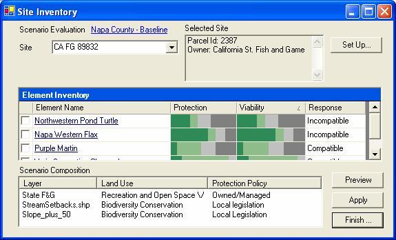
55 Vista: element data integration Example: Red Cockaded Woodpacker A Federal Endangered Species with required protection Distribution based on potential habitat Ground surveys required to verify Development restrictions and/or HCP may be required Blue occurrences meet adequate size requirements, red areas are below minimum size but still may provide habitat.

56 Depicting Conservation Values Vista conservation value summary. Overlays and combines attributes of conservation elements to provide relative value scores

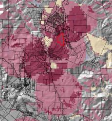
57 Integrating Transportation Planning Categorized Vista output used as input to Quantm road routing optimization software (black lines indicate 50 optional alignments and purple indicates best performing option)
58 Integrating Land Use Planning CommunityViz growth model on right Current land use map indicating mostly green space Growth model map indicating substantial new urbanization

59 Evaluating Transportation Impacts Road corridor imported and evaluated in Vista. Compatibility conflict map for current land use with new proposed road. Pink-red colors represent and index of number of conservation elements in conflict with the land use/infrastructure preventing goal achievement

60 Evaluating Transportation Impacts All tools provide reports. Example Vista report on quantitative goal achievement for conservation objectives

61 Evaluating Cumulative Impacts Imported & evaluated CommunityViz urban growth model and Quantm road into Vista to evaluate cumulative impacts. Pink-red colors represent and index of number of conservation elements in conflict with the land use/infrastructure

62 Developing Mitigation Scenarios CommunityViz growth model on right & Vista mitigation scenario Current Vista mitigation land use scenario map indicating mostly green space Growth model map indicating substantial new urbanization
 indicates a management conflict between a shrubland and forest to support an endangered species.")
63 Evaluating Cumulative Impacts Compatibility conflict map for mitigated scenario.. Remaining conflict (red) indicates a management conflict between a shrubland and forest to support an endangered species. Such remaining conflicts must be resolved over larger spatial extents.
Overview of Southwestern Pennsylvania Commission s (SPC) 2040 Long Range Transportation Plan (LRTP)
 2040 Long Range Transportation Plan (LRTP)") Overview of Southwestern Pennsylvania Commission s (SPC) 2040 Long Range Transportation Plan (LRTP) Presented to Pennsylvania Agency Coordination Meeting May 27, 2015 Doug Smith & Ryan Gordon 1 Southwestern
Overview of Southwestern Pennsylvania Commission s (SPC) 2040 Long Range Transportation Plan (LRTP) Presented to Pennsylvania Agency Coordination Meeting May 27, 2015 Doug Smith & Ryan Gordon 1 Southwestern
Great Lakes Conservation Blueprint for Terrestrial Biodiversity on the Canadian Shield
 Great Lakes Conservation Blueprint for Terrestrial Biodiversity on the Canadian Shield Bonnie L. Henson 1, Kara E. Brodribb 2 and John L. Riley 3 1 Ontario Ministry of Natural Resources 2,3 The Nature
GIS to Estimate Archaeological Site Loss and Develop Conservation Strategies
 GIS to Estimate Archaeological Site Loss and Develop Conservation Strategies Terry Jackson Office of Decision Support Systems Planning and Environmental Management Division Georgia Department of Community
National Association of Conservation Districts. Kris Hoellen Vice President, Sustainable Programs The Conservation Fund September 19, 2013
 National Association of Conservation Districts Kris Hoellen Vice President, Sustainable Programs The Conservation Fund September 19, 2013 Our Mission The Conservation Fund forges partnerships to conserve
Countywide Green Infrastructure
 Montgomery County s Countywide Green Infrastructure F U N C T I O N A L M A S T E R P L A N The Maryland National Capital Park and Planning Commission INFRASTRUCTURE An underlying base or foundation especially
Florida Forever Conservation Needs Assessment Overview Maps
 Florida Forever Conservation Needs Assessment Overview Maps Prepared by Florida Natural Areas Inventory, The maps in this document are derived from the Florida Forever Conservation Needs Assessment, an
ROLE OF LANDSCAPE CONSERVATION COOPERATIVES IN EVERGLADES RESTORATION
 ROLE OF LANDSCAPE CONSERVATION COOPERATIVES IN EVERGLADES RESTORATION GEER April 2017 Steve Traxler 1, Todd Hopkins 1, Beth Stys 2 1 US Fish and Wildlife Service 2 Florida Fish & Wildlife Conservation
systems is available on the Colorado Wetland Information Center (CWIC) website.
 website.") Colorado Natural Heritage Program Wetland Program Plan -- Dec 2015 Status Update and Addendum -- The Colorado Natural Heritage Program (CNHP) developed a Wetland Program Plan (WPP) in 2010 for the planning
Colorado Natural Heritage Program Wetland Program Plan -- Dec 2015 Status Update and Addendum -- The Colorado Natural Heritage Program (CNHP) developed a Wetland Program Plan (WPP) in 2010 for the planning
Virginia DCR- Natural Heritage Program. Tools for Linking Conservation and Transportation Planning
 Virginia DCR- Natural Heritage Program Tools for Linking Conservation and Transportation Planning November 9, 2009 MISSION: to conserve Virginia's biodiversity through statewide biological inventory, protection,
Integration of Planning & Environmental Analysis in Transportation
 Integration of Planning & Environmental Analysis in Transportation How Natural Resources Conservation Fits into SAFETEA-LU Planning Rules Transportation Research Board Annual Meeting January 2008 Jeff
INTEGRATING PROTECTED AREAS INTO THE WIDER LANDSCAPE, SEASCAPE AND RELATED SECTORS. An Overview
 INTEGRATING PROTECTED AREAS INTO THE WIDER LANDSCAPE, SEASCAPE AND RELATED SECTORS An Overview USING AN EXAMPLE FROM NORTHEAST US Relationship of IPAWLS guide to other planning and assessment processes
GeoPlanner SM for ArcGIS : An Introduction
 GeoPlanner SM for ArcGIS : An Introduction Greg Pleiss Robert Stauder Esri UC 2014 Technical Workshop Agenda Application Overview Specific Capabilities - Configuration - Avaliable Data - Spatial Analysis
Integrating LEED ND & SITES Into Your Design Approach
 Integrating LEED ND & SITES Into Your Design Approach Joshua C. Sloan, RLA, ASLA, AICP, LEED AP ND, SITES AP Stephen K. Cook, RLA, ASLA, LEED AP O+M VIKA MD, LLC Planning Landscape Architecture Engineering
GREEN INFRASTRUCTURE PLANNING GUIDE
 GREEN INFRASTRUCTURE PLANNING GUIDE Authors: C Davies, R MacFarlane, C McGloin, MRoe. Abbreviation Green Infrastructure is frequently abbreviated to as GI and Green Infrastructure Planning as GIP. Contents
Community Conservation Workshop. Saranac River Basin Communities
 Community Conservation Workshop Saranac River Basin Communities 2 Community Conservation Program Welcome! We have designed a Community Conservation Program that listens to the needs of community members.
Executive Summary. Essential Connectivity Map (Figure ES-1)
") Executive Summary The California Department of Transportation (Caltrans) and California Department of Fish and Game (CDFG) commissioned the because a functional network of connected wildlands is essential
Executive Summary The California Department of Transportation (Caltrans) and California Department of Fish and Game (CDFG) commissioned the because a functional network of connected wildlands is essential
Key Elements of Successful Conservation Planning. John Paskus October 17, 2013 Pierce Cedar Creek Institute Michigan Natural Features Inventory
 Key Elements of Successful Conservation Planning John Paskus October 17, 2013 Pierce Cedar Creek Institute Michigan Natural Features Inventory What is Conservation Planning? Pressey et al (2008): The process
I ll be talking about the Designing Sustainable Landscapes project today. This is a large integrated modeling effort our group at UMass has been
 1 I ll be talking about the Designing Sustainable Landscapes project today. This is a large integrated modeling effort our group at UMass has been working on for the past 5 years, in close collaboration
Arkansas River Corridor
 Planning for Access Welcome to the Access Project. This project is a recreational planning effort in response to an interest by regional communities along the Arkansas River corridor. The project plan
Summary of Action Strategies
 Strategic Action Plan 6 Summary of Action Strategies Action Strategy Categories: 1. Organization and Management 2. Implementation 3. Marketing and Promotion This chapter summarizes all of the action strategies
Green Infrastructure. by Karen Engel, NYS DEC. NYS Department of Environmental Conservation
 Green Infrastructure by Karen Engel, NYS DEC What is Green Infrastructure? For some it s all about water Green Infrastructure techniques use soils and vegetation to infiltrate, evapotranspirate, and/or
Community Conservation Workshop. Lake Placid
 Community Conservation Workshop Lake Placid 2 Community Conservation Program Welcome! We have designed a Community Conservation Program that listens to the needs of community members. We are conducting
The Language of Geography. Health and Human Services
 The Language of Geography Health and Human Services Cover Points of Distribution: this Esri map shows population density in relation to vaccine distribution centers, helping health officials perform a
Green Infrastructure Planning for Sustainability and Resiliency
 Green Infrastructure Planning for Sustainability and Resiliency Linking Lands and Communities in the Land-of-Sky Region SAMAB Conference - November 18, 2010 www.linkinglands.org Linda Giltz, AICP, Regional
Describing the Integrated Land Management Approach
 Describing the Integrated Land Management Approach ISBN No. 978-0-7785-8902-0 (Online Edition) Pub No. I/422 What is Integrated Land Management? Integrated land management (ILM) is the strategic, planned
Northeast Conservation
 Northeast Conservation Framework What is it and why do we need it? National LCC Workshop Denver CO March 2012 Northeast Conservation Framework History Context Future NA Landscape Conservation Cooperative
TOWN OF BETHLEHEM OPEN SPACE CONSERVATION PLAN PUBLIC MEETING: OCTOBER 12, 2017
 TOWN OF BETHLEHEM OPEN SPACE CONSERVATION PLAN PUBLIC MEETING: OCTOBER 12, 2017 Welcome and Agenda 6:00 6:45: Open House, Part One 6:45 7:15: Presentation and Questions 7:15 8:00: Open House, Part Two
Consolidated Workshop Proceedings Report
 United Nations International Strategy for Disaster Reduction Regional Office for Arab States THE WORLD BANK Syrian Ministry of Local Administration Consolidated Workshop Proceedings Report Regional Workshop
Peninsular Florida Landscape Conservation Cooperative. Marine and Estuarine Priority Resources and Conservation Targets
 Peninsular Florida Landscape Conservation Cooperative Marine and Estuarine Priority Resources and Conservation Targets Why are we here today? Workshop Goals: Develop a list of potential conservation targets
A Delta Renewed: A Guide to Science Based Ecological Restoration in the Delta
 A Delta Renewed: A Guide to Science Based Ecological Restoration in the Delta J. Letitia Grenier, San Francisco Estuary Institute, letitia@sfei.org Julie Beagle, San Francisco Estuary Institute, julieb@sfei.org
Consolidated Workshop Proceedings Report
 Consolidated Workshop Proceedings Report Regional Workshop on Urban Risk Damascus, Syria, November 4. 5. 2009 UNISDR, the Global Facility for Disaster and Recovery (GFDRR) of the World Bank, UNDP Syria
4. What are the goals of the Kawarthas, Naturally Connected project? 7. What are watersheds and why are they being used as the project boundaries?
 Frequently Asked Questions (FAQs) 1. What are Natural Heritage Systems (NHS)? 2. Why are they important? 3. Which areas of the province have undertaken NHS projects? 4. What are the goals of the Kawarthas,
Road Ecology in Practice: Building Resiliency of Urban Ecosystems through Informed Road Network Planning
 Road Ecology in Practice: Building Resiliency of Urban Ecosystems through Informed Road Network Planning Outline What is road ecology? Why is road ecology important? TRCA and road ecology application Peel
Historic Asset Management A Decision Support Process for Balanced Consideration of Mission Utility, Historic Value, and Facility Condition
 Historic Asset Management A Decision Support Process for Balanced Consideration of Mission Utility, Historic Value, and Facility Condition Joe Lockerd; Cardno TEC Kurt Schweigert; Cardno TEC Adriane Fowler
STEWARDSHIP OF LONG ISLAND SOUND S ECOLOGICAL AND RECREATIONAL RESOURCES
 STEWARDSHIP OF LONG ISLAND SOUND S ECOLOGICAL AND RECREATIONAL RESOURCES Robin Kriesberg, Save the Sound, Inc. Thomas Halavik, US Fish and Wildlife Service Coastal Program An Initiative to Identify, Protect
Chapter 5: Natural Resources and Environment
 NATURAL RESOURCES AND ENVIRONMENT 5-1 5 Chapter 5: Natural Resources and Environment BACKGROUND AND INTENT Urban expansion represents the greatest risk for the future degradation of existing natural areas,
The Landscape Project. New Jersey Department of Environmental Protection Division of Fish and Wildlife Endangered and Nongame Species Program
 The Landscape Project New Jersey Department of Environmental Protection Division of Fish and Wildlife Endangered and Nongame Species Program New Jersey is One of the smallest states in the country Yet
The Esri Public Works Platform. More Than Mapping
 The Esri Public Works Platform More Than Mapping Intelligent Public Works Sustaining a safe, vibrant community requires a smart public works system. Esri created a platform that connects public works departments
Infrastructure, Development and Enterprise Services. Natural Heritage Action Plan (NHAP) Project Initiation
 Project Initiation") Staff Report To Service Area Committee of the Whole Infrastructure, Development and Enterprise Services Date Monday, March 6, 2017 Subject Natural Heritage Action Plan (NHAP) Project Initiation Report
Staff Report To Service Area Committee of the Whole Infrastructure, Development and Enterprise Services Date Monday, March 6, 2017 Subject Natural Heritage Action Plan (NHAP) Project Initiation Report
Biodiversity Standard
 14 Sustainability Service + This is a controlled document whilst viewed at https://universityofleeds.myeqms.com/login/login.aspx. Once downloaded or printed it becomes an uncontrolled copy. Please check
How keep.eu can be used? Baiba Liepa, Interact Programme
 How keep.eu can be used? Baiba Liepa, Interact Programme What is keep.eu Knowledge management tool including database, website, search engine Available on www.keep.eu The only source of aggregated information
Illiana Corridor CPG/TTF Meeting #1
 Illiana Corridor CPG/TTF #1 March 14, 2013 #10 1 Agenda Tier One Recap What happens in Tier Two? Tier Two Purpose and Need Identify Range of Alternatives Landowner Outreach Initial Context Sensitive Solution
Landscape Ecology and EA in Ontario:
 Landscape Ecology and EA in Ontario: Bridging Gaps in Biodiversity Assessment Christina Rehbein, Dr. Scott Mitchell & Dr. Mike Brklacich Carleton University OAIA 2017 18 October 2017 Biodiversity and EA
Smart City Governance URBIS Solutions. David Ludlow, Assoc. Professor European Smart Cities University of the West of England, Bristol
 Smart City Governance URBIS Solutions David Ludlow, Assoc. Professor European Smart Cities University of the West of England, Bristol Integrated smart city model Smart Mobility Services focused on decreasing
The New Mexico Opportunity Mapping Project
 The New Mexico Opportunity Mapping Project Elaine Kohrman 1, Joe Zebrowski 2, Susan Rich 3 1 United States Forest Service, Cibola National Forest 2 New Mexico Highlands University, New Mexico Forest and
National Park Service U.S. Department of the Interior. Climate Change Response and Cultural Landscape Preservation
 Climate Change Response and Cultural Landscape Preservation National Park Service Climate Change Response Strategy (Sept. 2010) Preserving the Nation s Heritage The preservation and protection of cultural
50-year Water & Wetland Vision for England WORKSHOP DETAILS
 50-year Water & Wetland Vision for England Workshop 3: Wetland vision maps; your feedback on draft maps, methodology and ways forward 7 th December 2006 WORKSHOP DETAILS Theme 1: Methodology and prioritisation
Fingal Development Plan & Green Infrastructure. Nicholas O Kane Senior Executive Planner Fingal County Council
 Fingal Development Plan 2011-2017 & Green Infrastructure Nicholas O Kane Senior Executive Planner Fingal County Council 2011 Fingal Development Plan Must be in compliance with National Spatial Strategy
Photo by Carlton Ward Jr. Executive Summary
 Photo by Carlton Ward Jr. Executive Summary The Cooperative Conservation Blueprint (Blueprint) is a multi-partner strategic conservation process developed by the Florida Fish and Wildlife Commission (FWC)
Public Review Draft Oceanside Subarea Habitat Conservation Plan/ Natural Communities Conservation Plan
 Oceanside Subarea Habitat Conservation Plan/ Natural Communities Conservation Plan Prepared for City of Oceanside Planning Department 300 N. Coast Highway Oceanside, CA 92054 Prepared by Ogden Environmental
Table of Contents TABLE OF CONTENTS SECTION TITLE PAGE
 TABLE OF CONTENTS SECTION TITLE PAGE 1 INTRODUCTION AND OVERVIEW 1-1 1.1 Purpose and Need 1-1 1.2 Goals and Objectives 1-3 1.3 Overview of the Planning Process 1-5 1.4 Federal and State Requirements and
New Tools for Land Management: A Quick Introduction to Ecological Site Descriptions
 New Tools for Land : A Quick Introduction to Ecological Site Descriptions Land management agencies have the job of managing natural resources for multiple uses in a sustainable manner. A sound understanding
FINDING WAYS TO CONNECT
 FINDING WAYS TO CONNECT Linking habitat together to function as an ecological whole The Green Leap: A Primer for Conserving Biodiversity in Subdivision Development. Mark E. Hostetler. University of California
Making Data Work for You: Free Mapping Tools for Prioritization and Property Research
 Making Data Work for You: Free Mapping Tools for Prioritization and Property Research Ariel Maiorano amaiorano@massaudubon.org Abby Hardy-Moss abby@ecga.org Essex County Open Space Conference March 25,
User Advocacy Group. Rohit Gupta
 User Advocacy Group Rohit Gupta Agenda Introduction to User Advocacy Group (UAG) UAG Process User Communities Initiatives User Advocacy Group Mission To enhance the productivity of the user community by
SAN RAFAEL GENERAL PLAN 2040 INTRODUCTION AND OVERVIEW
 SAN RAFAEL GENERAL PLAN 2040 INTRODUCTION AND OVERVIEW Steering Committee Presentation February 14, 2018 Purpose of General Plan Guide land use and development decisions Coordinate transportation, infrastructure,
Presented by: Remy Norbert DUHUZE Director/ER&PC REMA
 Presented by: Remy Norbert DUHUZE Director/ER&PC REMA 1 Presentation Outline What is Environment, Social and Economic Impact Assessment? Objectives and Principles of EIA EIA background & regulations Stakeholders
Scope of Services. River Oaks Boulevard (SH 183) Corridor Master Plan
 Corridor Master Plan") Scope of Services River Oaks Boulevard (SH 183) Corridor Master Plan PROJECT AREA The project area consists of the River Oaks Boulevard (SH 183) corridor bounded by SH 199 at the northern end and the Trinity
Scope of Services River Oaks Boulevard (SH 183) Corridor Master Plan PROJECT AREA The project area consists of the River Oaks Boulevard (SH 183) corridor bounded by SH 199 at the northern end and the Trinity
NORTHERN LANDS NORTHERN LEADERSHIP
 NORTHERN LANDS NORTHERN LEADERSHIP The GNWT Land Use and Sustainability Framework Our Lands, Our Interests, Our Future ii Land is Life MESSAGE FROM THE PREMIER Land is life. It is the link to our past.
RECREATION, OPEN SPACE AND GREENWAYS ELEMENT GOALS, OBJECTIVES, AND POLICIES
 RECREATION, OPEN SPACE AND GREENWAYS ELEMENT GOALS, OBJECTIVES, AND POLICIES GOAL R-1: DEVELOP A RECREATION, OPEN SPACE AND GREENWAYS SYSTEM AS AN INTEGRAL COMPONENT OF AN OVERALL, COUNTY-WIDE ECONOMIC
VCA Guidance Note. Contents
 Contents 1. Introduction... 2 2. Who can register a VCA?... 2 3. VCAs and sustainable development... 3 4. Verifying conservation performance... 4 4.1 Transparent, voluntary commitments... 4 4.2 Independent
Esri Roads and Highways: Integrating and Developing LRS Business Systems
 Esri Roads and Highways: Integrating and Developing LRS Business Systems Tom Hill Esri UC 2014 Technical Workshop Overview: Esri Roads and Highways Esri UC 2014 Technical Workshop Esri Roads and Highways:
Growth Management Planning in the Central Puget Sound Region. Today s Presentation. Puget Sound Region. New Partners for Smart Growth
 Growth Management Planning in the Central Puget Sound Region New Partners for Smart Growth Denver, CO January 2006 Today s Presentation Regional growth management in central Puget Sound, WA Regional geographies
San Francisco Bay Area Upland Habitat Goals Project
 San Francisco Bay Area Habitat Preserving Biological Diversity for Future Generations A of the Bay Area Open Space Council funding provided by: California State Coastal Conservancy Gordon and Betty Moore
Environment and Natural Resources Trust Fund 2018 Request for Proposals (RFP)
") Environment and Natural Resources Trust Fund 2018 Request for Proposals (RFP) Project Title: Data Acquisition to Develop Native Mussel Habitat Suitability Category: A. Foundational Natural Resource Data
Environment and Natural Resources Trust Fund 2018 Request for Proposals (RFP) Project Title: Data Acquisition to Develop Native Mussel Habitat Suitability Category: A. Foundational Natural Resource Data
10/23/18. Science informed regional planning: opportunities for better outcomes. Seeking Better Outcomes for Our Regions
 SEGRA 2018: Beyond the Boom: opportunities for growth and vitality Acknowledge the Traditional Owners of the country where we are meeting today Science informed regional planning: opportunities for better
Ecosystem Restoration Business Line Budgeting A Systems Approach
 Ecosystem Restoration Business Line Budgeting A Systems Approach Laura Orr (NWS), Shawn Phillips (MVM), Greg Steele (NAO) Introduction Chesapeake Bay Bridge Mouth of Mississippi River Bonneville Dam Fish
Collaborative Conservation across Landscapes: Experiences from the Upper Midwest and Great Lakes LCC 2/29/2016. GreatLakesLCC.org
 Collaborative Conservation across Landscapes: Experiences from the Upper Midwest and Great Lakes LCC 2/29/2016 GreatLakesLCC.org Personal introduction Brad Potter - Science Coordinator for the Upper Midwest
German ecological network legal base, scientific foundation and international context
 A future task in good hands German ecological network legal base, scientific foundation and international context Dr. Uwe Riecken Federal Agency for Nature Conservation (BfN) Bonn, Germany 9 th Pan-European
Town of Oakville Streetscape Strategy
 Town of Oakville Streetscape Strategy Endorsed by PDC on February 10, 2014 (PD-011-14) Town of Oakville Streetscape Strategy [endorsed by PDC February 10, 2014] 0 Town of Oakville Streetscape Strategy
INTERMOUNTAIN WEST JOINT VENTURE Strengthening Alliances for Conservation
 INTERMOUNTAIN WEST JOINT VENTURE Strengthening Alliances for Conservation THE PEOPLE OF THE IWJV The people of the Intermountain West are our greatest asset. We, at the IWJV, believe in forging productive,
CALGARY: City of Animals Edited by Jim Ellis
 CALGARY: City of Animals Edited by Jim Ellis ISBN 978-1-55238-968-3 THIS BOOK IS AN OPEN ACCESS E-BOOK. It is an electronic version of a book that can be purchased in physical form through any bookseller
Natomas Joint Vision Open Space Plan
 Natomas Joint Vision Open Space Plan First Workshop series The City of Sacramento The County of Sacramento LAFCo ERA Economic Research Associates EIP Associates a Division of PBS & J Natomas Joint Vision
THE FUTURE OF THE MCABEE FOSSIL BEDS HERITAGE SITE - Aligning the management of the site with fossil management approaches
 November 2014 A world class site with an interpretive and research centre that explores the role of fossils in our lives in a natural and cultural setting. PURPOSE The purpose of this document is to articulate
495/MetroWest Development Compact Plan Citizen Planner Training Collaborative Conference. March 17, 2012
 495/MetroWest Development Compact Plan Citizen Planner Training Collaborative Conference March 17, 2012 Project Process Local and Regional Priority Areas Growth Scenarios Transportation Investment Categories
Ontario Invasive Plant Council
 Ontario Invasive Plant Council Ontario Invasive Plant Council What is the problem? How it all began 2007 AGM Highlights from the framework Mission statement Objectives What has the council be up to? Council
Tracking spatiotemporal patterns of building vulnerabilities and evacuations during flood hazards
 Tracking spatiotemporal patterns of building vulnerabilities and evacuations during flood hazards Shane Hubbard Junchuan Fan Kathleen Stewart Emily White The University of Wisconsin Madison, SSEC/CIMSS
Vaughan Metropolitan Centre (VMC) Black Creek Renewal CLASS ENVIRONMENTAL ASSESSMENT
 Black Creek Renewal CLASS ENVIRONMENTAL ASSESSMENT") PUBLIC INFORMATION CENTRE Vaughan Metropolitan Centre (VMC) Black Creek Renewal Wednesday, May 10, 2017 6:00 p.m. to 8:00 p.m. Add photo Project Management, Environmental Assessment, Stormwater Management
PUBLIC INFORMATION CENTRE Vaughan Metropolitan Centre (VMC) Black Creek Renewal Wednesday, May 10, 2017 6:00 p.m. to 8:00 p.m. Add photo Project Management, Environmental Assessment, Stormwater Management
PDS June 1, 2016 Page 1. Planning and Development Committee. MEETING DATE: Wednesday, June 01, 2016
 Page 1 REPORT TO: Planning and Development Committee MEETING DATE: Wednesday, June 01, 2016 SUBJECT: ROPA 12: Project Initiation Report Regional Official Plan Amendment (ROPA # 12) Watercourse Policies
2014 South Atlantic LCC
 2014 South Atlantic LCC Annual Report 1 Allie Stewart, U.S. FWS The South Atlantic LCC s 2014 Annual Report this year of progress and accomplishments is dedicated to South Atlantic LCC Coordinator, Ken
Lower Columbia River and Coastal Landscape Conservation Design
 Today s Presenters: Lower Columbia River and Coastal Landscape Conservation Design John Mankowski, North Pacific Landscape Conservation Cooperative Sara Evans-Peters, Pacific Birds Tom Miewald, US Fish
A global view of integrated closure and legacy planning
 18 September 2013 A global view of integrated closure and legacy planning Mine Closure 2013, Eden Project, Cornwall Dr. William Adams General manager, Legacy and Closure A changing business climate The
PRESENTATION ON JOHANNESBURG S BIODIVERSITY PROGRAMME
 PRESENTATION ON JOHANNESBURG S BIODIVERSITY PROGRAMME Member of Mayoral Committee: Cllr Prema Naidoo Environmental Management & Johannesburg City Parks PRESENTATION OVERVIEW Jo burg Overview & Context
Miami Valley Regional Planning Commission Regional Land Use Planning
 Miami Valley Regional Planning Commission Regional Land Use Planning This document provides an overall approach on the region-based land use planning process, outlining the major tasks and work elements
I. STAFF POLICY RECOMMENDATIONS. The following RMP policy strategies are proposed by staff in support of a Scenic Resource Protection Program:
 Policy Consideration: Scenic Resource Protection Program Status: For Consideration by the Highlands Council at September 14, 2006 Work session Date: September 12, 2006 I. STAFF POLICY RECOMMENDATIONS The
FOUR MILE RUN VALLEY WORKING GROUP AND CHARGE Adopted April 16, 2016 Amended July 19, 2016
 FOUR MILE RUN VALLEY WORKING GROUP AND CHARGE Adopted April 16, 2016 Amended July 19, 2016 Working Group Charge The Working Group is charged by the County Board to collaborate with staff to provide commission,
A Network Theory Framework for Urban Cultural Heritage Conservation. Manal Ginzarly LEMA, Université de Liège
 A Network Theory Framework for Urban Cultural Heritage Conservation Manal Ginzarly LEMA, Université de Liège Objective Develop an ecological approach to the integration of heritage conservation and urban
Landscape Conservation Design April, 2014
 Designing Sustainable Landscapes in the Northeast A project of the North Atlantic Landscape Conservation Cooperative & Northeast Climate Science Center Landscape Conservation Design April, 2014 Conceptual
LANDSCAPE SCALE PLANNING AND SITING FOR SHALE DEVELOPMENT
 LANDSCAPE SCALE PLANNING AND SITING FOR SHALE DEVELOPMENT An Energy by Design approach to reducing the overall environmental footprint. MICHELLE MCGREGOR SR. OIL & GAS DEVELOPMENT ADVISOR Agenda Introduction
Large Landscape Restoration and the National Park System
 National Park Service U.S. Department of the Interior Large Landscape Restoration and the National Park System April 21, 2016 National Conference on Ecosystem Restoration Raymond M. Sauvajot, Ph.D. Associate
FOUR MILE RUN VALLEY WORKING GROUP AND CHARGE
 FOUR MILE RUN VALLEY WORKING GROUP AND CHARGE Adopted April 16, 2016 Amended July 19, 2016 Overview of Integrated Effort The overall goal of the Four Mile Run Valley (4MRV) initiative is to develop a comprehensive
Biodiversity Action Plan Background Information for discussion purposes
 Biodiversity Action Plan Background Information for discussion purposes Our commitment As directed by Council, The City of Calgary has agreed to sign the Durban Commitment, an international agreement on
Draft Resolution XII.10
 12 th Meeting of the Conference of the Parties to the Convention on Wetlands (Ramsar, Iran, 1971) Punta del Este, Uruguay, 1-9 June 2015 Ramsar COP12 DR10, Rev. 2 21:45, 8 June Draft Resolution XII.10
Figure 1. Proposed Strategic Habitat Conservation Areas for Florida
 Figure 1. Proposed Strategic Habitat Conservation Areas for Florida Critical Lands and Waters Identification Project (CLIP) Cooperative Effort Century Commission for Sustainable Florida Florida Natural
Green Infrastructure Plan Evaluation Frameworks
 Green Infrastructure Plan Evaluation Frameworks McDonald, L., W. Allen, M. Benedict, & K. O'Connor Keywords green, infrastructure, planning, conservation, landscape, sprawl, framework, evaluation, taxonomy,
Loebl Schlossman & Hackl
 Loebl Schlossman & Hackl in association with PSA-Dewberry Chicago, IL EIU Experience 1999 Plan Eastern Illinois University 1999 and 2002 Campus Master Plans Charleston, IL 2002 Update Highly Participatory
Toronto Complete Streets Guidelines
 c. DTAH 58 60 3.1 70 3.2 Performance Measurement 71 3.3 Exceptions Chapter 3 describes the five general steps in the street design process. Not all projects follow these steps, as the number of steps and
NJ Habitat Connectivity Initiative
 NJ Habitat Connectivity Initiative Full Working Group Update #1 Spotted Salamander Crossing Road in Northern NJ Wildlife Habitat Connectivity Initiative A strategic plan to reconnect New Jersey s landscape
Scope of Work Urban Design Review Framework Monitoring Program Item #7.1
 1.0 Background The Urban Design Review Framework (Framework) project (PUD2017-0601) explored design review protocols and processes, and proposed revisions to achieve better built outcomes. In 2017 July,
Smart Growth for Dallas
 Smart Growth for Dallas Data-driven decisions for the future of Dallas parks, open spaces, and green infrastructure Dallas Park and Recreation Board March 10, 2016 Agenda I. Welcome and Introductions II.