City Council Special Meeting. August 9, 2017
|
|
|
- Alexander Golden
- 5 years ago
- Views:
Transcription


1 DREAMPORT VILLAGES CASA GRANDE City Council Special Meeting August 9, 2017


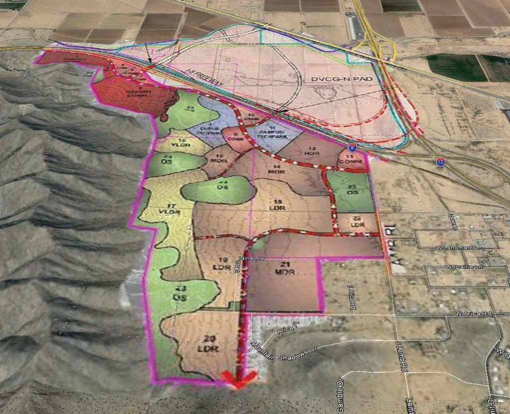
2 Regional Gateway Commerce Center PAD Casa Grande Mountain Ranch PAD ARICA RD. OVERVIEW


3 Dreamport Villages North 618 acre commercial resort Amusement park Extreme outdoor sports park Resort hotel, motels ARICA RD. OVERVIEW
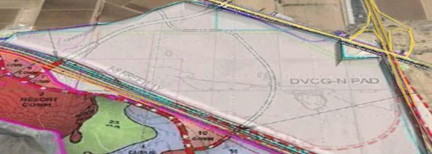


4 Commercial Resort: hotel, wildlife animal attraction, restaurant, live entertainment Campus/technical park Dreamport Villages North 618 acre commercial resort Amusement park Extreme outdoor sports park Resort hotel, motels Dreamport Villages South 872 acres ARICA RD. OVERVIEW


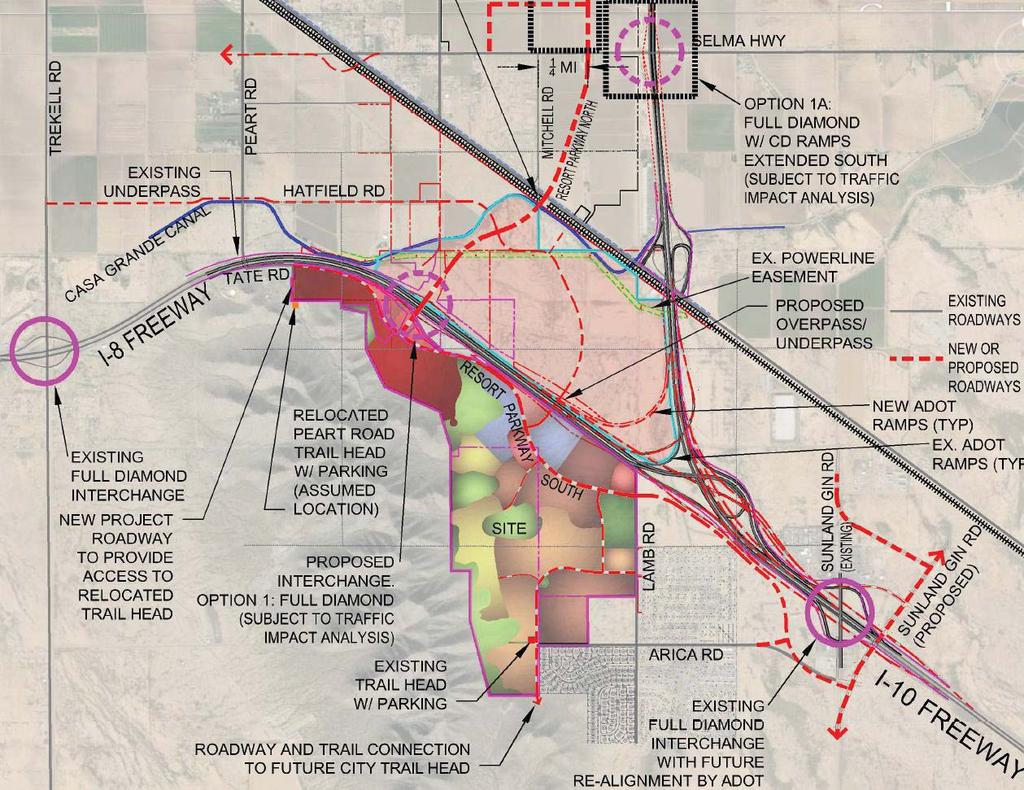
5 SELMA I-10 INTERCHANGE I-8 INTERCHANGE UPPR OVERPASS To Sunland Gin ARICA RD. TRANSPORTATION OVERVIEW


6 To I-8 interchange ARICA RD. TRANSPORTATION SOUTH OF I-8

7 FLORENCE BLVD interchange INTERSTATE 10 SELMA HWY UPPR overpass interchange TRANSPORTATION NORTH OF I-8

8 ARICA RD. HISTORY OVERVIEW

9 Office/Light Industrial: acres Corporate Office: acres Garden Office: 34.7 acres Open Space: 8.9 acres Light Industrial: 25 acres Business Park: 44.2 acres Commercial: 8.8 acres EXISTING NORTH PAD HENNESS RD.


10 UR UR I-1 Office/Light Industrial: acres Corporate Office: acres RESORT COMMERCIAL LAND USE Garden Office: 34.7 acres Open Space: 8.9 acres Light Industrial: 25 acres Business Park: 44.2 acres Commercial: 8.8 acres EXISTING NORTH PAD RESORT RESHENNESS PARKWAY RD.
 RESORT COMMERCIAL LAND USE RV")

11 400 ft. tall amusement park structures 260 ft. tall buildings (hotel) RESORT COMMERCIAL LAND USE RV park Outdoor/indoor entertainment Boat rides Retail Train station Movie studio Warehousing PROPOSED NORTH PAD RESORT PARKWAY

12 E PROPOSED NORTH PAD S N W

13 NEIGHBORHOODS COMMERCE & BUSINESS GENERAL PLAN COMPLIANCE NORTH PAD

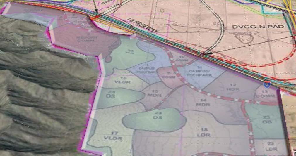
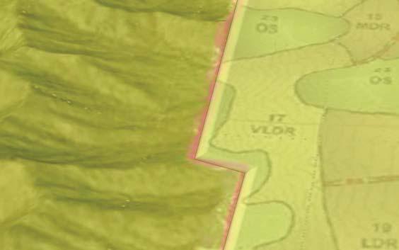
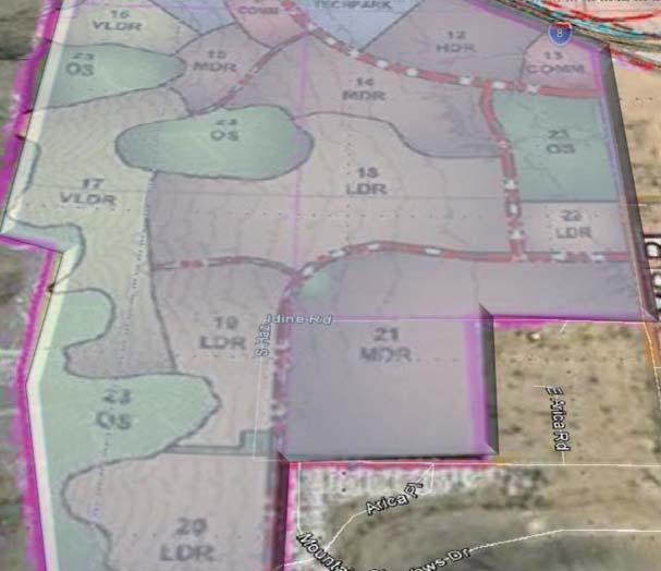
14 Open Space: 168 acres High Density Residential: 52.4 acres Commercial: 28.7 acres EXISTING SOUTH PAD OVERVIEW Resort/Hotel & Conference Center: 31.1 acres Mixed Use: Commercial/ Office: 38.7 acres School: 13 acres Medium Density Residential: 94 acres LAMB RD. ARICA RD. Low Density Residential: acres Very Low Density Residential: 69.2 acres
15 Urban Ranch 304 ACRE OPTION PARCEL R-1 Single Family PROPOSED SOUTH PAD
 Restaurants Outdoor entertainment/ 100 ft.")


16 RESORT COMMERCIAL: Wildlife attraction Hotel (80 ft.) Restaurants Outdoor entertainment/ 100 ft. max height for amusement/recreation structures Can go up to 150 ft. with C.U.P. COMMERCIAL Retail/restaurant Offices 35 ft. max height Campus/Tech Park Office/Restaurant College Dorms 50 ft. max height PROPOSED SOUTH PAD


17 Modified Setbacks and Lots Widths: Required Minimum side yards: 10 ft. and 10 ft. Minimum lot widths: 55 ft. Proposed for LDR/MDR Side yards of 5 ft. & 10ft./ 0 ft. & 10 ft. 50 ft. lot widths. PAD DESIGN STANDARDS FOR RESIDENTIAL

18 GENERAL PLAN COMPLIANCE SOUTH PAD


19 Commerce & Bus. 165 acres Neighborhoods 707 acres HILLTOP CITY OWNED OPTION PARCEL ARICA RD. GENERAL PLAN COMPLIANCE SOUTH PAD

20 COMPATIBILITY MEASURES WITHIN SOUTH PAD

21 Preservation of Trails/Trailheads COMPATIBILITY MEASURES WITHIN SOUTH PAD


22 TRAILHEADS Planned Casa Grande Mountain Community Trail Peart Rd Tang Parcel Existing Peart Rd. Trailhead-to be removed Land for new Trailhead/ Parking (City of CG) PAD City of CG Federal land COMPATIBILITY MEASURES WITHIN SOUTH PAD


23 Peart Trailhead TRAILHEADS Relocated Trailhead TRAILHEADS

24 TRAILHEADS HILLTOP Minimum one acre to be dedicated to City for Arica Trailhead CITY OWNED OPTION PARCEL ARICA RD. COMPATIBILITY MEASURES WITHIN SOUTH PAD

25 Preservation of Trails COMPATIBILITY MEASURES WITHIN SOUTH PAD
26 Perimeter Setbacks COMPATIBILITY MEASURES WITHIN SOUTH PAD

27 Saguaros COMPATIBILITY MEASURES WITHIN SOUTH PAD


28 Hillside Protection/VIEWS Prior to platting, grading, or development of any residential and non- residential parcels with slopes in excess of 8%, design guidelines shall be created and approved by the Planning Commission that establishes the following design principles: 1. Maximum cut and fill allowed. 2. Maximum driveway grade, width, and length. 3. Appropriate street width, length, and slope standards. 4. Maximum retaining wall heights. 5. Amount of natural vegetation removal allowed. 6. Alternative landscaping solution that results in planting that is low water demand and highly-compatible with the surrounding vegetation. 7. Standard that establishes which areas of lots to be potentially placed within preservation easements. 8. Structural designs that take up slope to minimize grading. 9. Method for design and placement of structures to ensure their blending in with the natural environment. COMPATIBILITY MEASURES WITHIN SOUTH PAD

29 Hillside Protection/VIEWS COMPATIBILITY MEASURES WITHIN SOUTH PAD

30 COMPATIBILITY MEASURES WITHIN SOUTH PAD

31 Hillside Protection/VIEWS COMPATIBILITY MEASURES WITHIN SOUTH PAD


32 Hillside Protection/VIEWS COMPATIBILITY MEASURES WITHIN SOUTH PAD

33 Hillside Protection/VIEWS COMPATIBILITY MEASURES WITHIN SOUTH PAD

34 Relationship of the plan elements to conditions both on and off the property; Conformance to the City's General Plan; Conformance to the City's Zoning Ordinance; The impact of the plan on the existing and anticipated traffic and parking conditions; The adequacy of the plan with respect to land use; Pedestrian and vehicular ingress and egress; Building location, height & building elevations; setbacks Landscaping; Open Space Lighting; Provision for utilities; Unloading areas / Screening CRITERIA FOR APPROVING PADS & AMENDMENTS


35 FOR PLANNING COMMISSION: Mailing to owners of property Publication in CG Dispatch Public Signage Comments received. FOR CITY COUNCIL: Mailing to owners of property Publication in CG Dispatch Public Signage Public Notice
36 HILLTOP ARICA RD. Staff & PZ RECOMMENDATION SOUTH
37 Staff Recommends that Planning & Zoning Commission forward a recommendation to City Council to APPROVE DSA (South) subject to the following technical modifications and conditions: TECHNICAL MODIFICATIONS: 1. Provide a cross section for Exhibit 8B w ithin the PAD guide that shows a full street right of way with a modified T - 28 Ca sa Grande Mountain Trail detail located wi t hin it where it would border the western boundary of the PAD ADDRESSED 2. Remove the proposed method of approving Major and Minor Amendments to the PAD, Additionally, ditionally, remove e the proposed modified review time fra me for Major Site Plans 3. Include public buildings/facilities as conditionally - permitted uses in all residential and residential categories. 4. Stipulate that the permitted height of Commercial O u t door Recreation Structures / Amusement Park structures is approvable up to ft. u nless by the issuance of a Conditional Use Permit up to a maximum of 1 50 ft. 5. Include a requirement within PAD that any saguaros over four feet in height located outside of o pen space areas that are to be removed, are to be relocated within the north or south Dreamport PAD to create a native landscaping theme. Staff & PZ RECOMMENDATION Dreamport Villages Casa Grande South
38 CONDITIONS OF APPROVAL for DSA : 1. Land must be dedicated to the City at the west boundary of the PAD for a roadway and trail access prior to the abandonment of the existing Peart trailhead. 2. A minimum of one acre of land must be dedicated to the City for the existing Arica Road trailhead and parking area prior to the approval of any Major Site Plans or Preliminary Plat within the PAD. 3. At the time of Major Site Plan or Preliminary Plat approval, applicant is to identify location of all saguaros over four feet in height that are located within areas that are to be disturbed. Prior to the approval of any grading permit these identified saguaros will need to have been relocated within the north or south PADs 4. A Master Water Report that details the water demands, sources and facilities needed to serve the PAD shall be submitted and approved by Arizona Water Company and the City prior to approval of any Major Site Plan within the Dreamport North or South PAD. 5. A Master Wastewater Report that details the wastewater demands and treatment facility shall be submitted and approved prior to approval of any Major Site Plan within the Dreamport North or South PAD 6. A Master Drainage Report shall be submitted and approved prior to approval of any Major Site Plans within the PAD. Said report to provide details regarding: The source and amount of off-site flows that are impacting the site and how said flows will be transmitted through the site. How development will occur within the Special Flood Hazard Area A in compliance with the City s special flood hazard area regulations. The amount of additional stormwater that will be created with the development of the site and how said stormwater will be managed and retained. 7. Provide a contour map with contour intervals no greater than two feet for the entire PAD and for property within one hundred feet of the boundary ( D.1) Staff & PZ Recommendation Dreamport Villages Casa Grande South

39 SELMA HWY. Staff & PZ Recommendation NORTH


40 Staff Recommends that Planning & Zoning Commission forward a recommendation to City Council to APPROVE DSA (North) subject to the following technical modifications and conditions: TECHNICAL MODIFICATIONS: 1. Remove language from pages 8 and 16 of the PAD regarding modification of the standard PAD amendment and Major Site Plan approval process. 2. Reduce the warehousing/distribution ADDRESSED and RV Park uses to be limited to 10% of the fross land areas of the PAD, respectively. 3. Provide a definition of short term stays within the RV Park for overnight or short term stays use description. Short-term cannot exceed a 30 day lease period. 4. Define, or otherwise eliminate/combine what Commercial Recreational Structures are. Specifically, an explanation is required as to how these differ from Amusement Park structures. If there is a clear distinction, stipulate the heights of Commercial Recreation Structures shall be subject to Planning Commission approval up to the maximum height at the time of Major Site Plan review. Staff Recommendation Dreamport Villages Casa Grande North
41 Staff Recommends that Planning & Zoning Commission forward a recommendation to City Council to APPROVE DSA (North) subject to the following technical modifications and conditions: TECHNICAL MODIFICATIONS Continued: 5. Provide a definition for Commercial R e sort. A clear description matching Commercial R e sort needs to be provided within the PAD to understand what structures/buildings are to occur in the area. y Section 4.3 D Site Design, G of the PAD that is located within Spe his area will be developed in complian 6. Modify Section 4.3 D Site Design, Grading and Drainage to include a graphic that illustrates the area of the PAD that is located within Special Flood Hazard Area A as well as text that desc ribes how this area will be develo ped in compliance with the Ciyt s Special Flood Hazard A r ea regulation. ( ) ADDRESSED rading and Drainage to include a graphic that illustrates the ecial Flood Hazard Area A as well as text that describes with the Ciyt s Special Flood Hazard Area 7. Provide a contour map with contour intervals no greater than two feed for the entire PAD and for property within one hundred feet of the boundary ( D.1) 8. Applicant is to provide information clarifying how the full body - contact lakes will use water sources that comply with A DWR & ADEQ standards. 9. Pr ovide information as to how the Trading Post property (APN: ) is to be provided access through the Dreamport development with the closure of the Cox Road UPPR crossing and intersection with Jimmie Kerr. 10. State how the Henness property (APN: ) is to be provided access. Staff & PZ Recommendation Dreamport Villages Casa Grande North
42 CONDITIONS OF APPROVAL FOR DSA A Master Water Report that details the water demands, sources and facilities needed to serve the PAD shall be submitted and approved by Arizona Water Company and the City prior to approval of any Major Site Plan within the Dreamport North or South PAD. 2. A Master Wastewater Report that details the wastewater demands and treatment facility shall be submitted and approved prior to approval of any Major Site Plan within the Dreamport North or South PAD 3. A Master Drainage Report shall be submitted and approved prior to approval of any Major Site Plans within the PAD. Said report to provide details regarding: a. The source and amount of off-site flows that are impacting the site and how said flows will be transmitted through the site. b. How development will occur within the Special Flood Hazard Area A in compliance with the City s special flood hazard area regulations. c. The amount of additional stormwater that will be created with the development of the site and how said stormwater will be managed and retained. Staff & PZ Recommendation Dreamport Villages Casa Grande North

43 DREAMPORT VILLAGES CASA GRANDE COUNCIL QUESTIONS
44 QUESTIONS/DISCUSSION
45 QUESTIONS/DISCUSSION
46 QUESTIONS
ARTICLE IX SPECIAL PERMIT USES
 ARTICLE IX SPECIAL PERMIT USES All special permit uses cited in Article IX and Attachment A of this Ordinance or any other Section of this Ordinance shall be subject to Site Plan Review. The procedures
Zoning Ordinance Chapter 10
 CHAPTER 10 - WASHES SECTION 10.0 GENERAL: A. The purpose of this Ordinance is to establish standards for development in or near Major and Minor Washes as defined in Appendix A Glossary of Terms and Definitions
DREAMPORT VILLAGES CASA GRANDE NORTH
 AN APPLICATION TO AMEND A PLANNED AREA DEVELOPMENT DSA-17-00002 DREAMPORT VILLAGES CASA GRANDE NORTH Casa Grande, Arizona 3rd Submittal July 14, 2017 Submitted For The Block Sports Company Submitted By,
The Ritz-Carlton, Paradise Valley
 The Ritz-Carlton, Paradise Valley 7000 E. Lincoln Drive Keys to Success Community Conversation II June 4, 2015 RITZ-CARLTON PARADISE VALLEY Town Council Study Session June 4, 2015 General Plan 2012 Land
CITY PLANNING COMMISSION AGENDA. ITEM NO(s): C.1 C.3 STAFF: STEVE TUCK
: C.1 C.3 STAFF: STEVE TUCK") Page 34 CITY PLANNING COMMISSION AGENDA ITEM NO(s): C.1 C.3 STAFF: STEVE TUCK FILE NOS: CPC ZC 12-00035 QUASI-JUDICIAL CPC NV 12-00036 QUASI-JUDICIAL AR DP 12-00039 QUASI-JUDICIAL PROJECT: APPLICANT: OWNER:
Page 34 CITY PLANNING COMMISSION AGENDA ITEM NO(s): C.1 C.3 STAFF: STEVE TUCK FILE NOS: CPC ZC 12-00035 QUASI-JUDICIAL CPC NV 12-00036 QUASI-JUDICIAL AR DP 12-00039 QUASI-JUDICIAL PROJECT: APPLICANT: OWNER:
At Your Disposal CUP Amendment, Lot 20, Village Service Commercial, at 128 Bastille Dr. (PLN17-208)
") MEMORANDUM Archuleta County Development Services Planning Department 1122 HWY 84 P. O. Box 1507 Pagosa Springs, Colorado 81147 970-264-1390 Fax 970-264-3338 TO: Archuleta County Planning Commission FROM:
MEMORANDUM Archuleta County Development Services Planning Department 1122 HWY 84 P. O. Box 1507 Pagosa Springs, Colorado 81147 970-264-1390 Fax 970-264-3338 TO: Archuleta County Planning Commission FROM:
2.0 AREA PLANS. Lakeside Business District. Lakeside Business District Land Use Categories:
 Lakeside Business District Lakeside Business District Land Use Categories: Campus Commercial Campus Commercial means a mixture of uses which includes corporate offices, office parks, hotels, commercial,
Application Number: SD Project Name: Walton Farms Preliminary Subdivision (acting as Master Plan)
") STAFF REPORT Town of Clayton Planning Department 111 E. Second Street, Clayton, NC 27520 P.O. Box 879, Clayton, NC 27528 Phone: 919-553-5002 Fax: 919-553-1720 Planning Board May 22, 2017 Application Number:
STAFF REPORT Town of Clayton Planning Department 111 E. Second Street, Clayton, NC 27520 P.O. Box 879, Clayton, NC 27528 Phone: 919-553-5002 Fax: 919-553-1720 Planning Board May 22, 2017 Application Number:
City of Sun Prairie Wetland Buffer Reduction Request
 City of Sun Prairie Wetland Buffer Reduction Request Westside Development Area January 9, 2017 Prepared by: City of Sun Prairie 300 E. Main Street Sun Prairie, WI 53590 BACKGROUND The City of Sun Prairie
Mitchell Ranch South MPUD Application for Master Planned Unit Development Approval Project Narrative. Introduction
 Mitchell Ranch South MPUD Application for Master Planned Unit Development Approval Project Narrative Introduction Mitchell Ranch South is a proposed single family (detached) residential development on
Major Subdivision Sketch Plan Checklist
 This checklist provides specific requirements that are apart of the Sketch process. The entire process is described by the Huntersville Subdivision Review Process which details all the submittal and resubmittal
Article 7.05 Manufactured Home Park Districts
 Article Manufactured Home Park Districts.01 Intent The purpose of the MHP Manufactured Home Park District is to give recognition to the fact that manufactured homes can provide satisfactory living conditions
VILLAGE OF CLEMMONS PLANNING BOARD DRAFT STAFF REPORT
 VILLAGE OF CLEMMONS PLANNING BOARD DRAFT STAFF REPORT PETITION INFORMATION Docket # C-226 Staff Megan Ledbetter Petitioner(s) JBJH Properties, LLC Owner(s) JBJH Properties, LLC Subject Property 5892-49-1766
GRAND COUNTY Planning Commission April 27, :00 P.M. Regular Meeting GRAND CENTER North End Meeting Room 182 No. 500 W.
 Type of Meeting: Facilitator: Attendees: Regular Meeting Dave Tubbs, Chair GRAND COUNTY Planning Commission April 27, 2016 6:00 P.M. Regular Meeting GRAND CENTER North End Meeting Room 182 No. 500 W.,
CITY PLANNING COMMISSION AGENDA ITEM: C STAFF: ROBERT TEGLER FILE NO: CPC PUD QUASI-JUDICIAL
 CPC AGENDA June 8, 2006 Page 37 CITY PLANNING COMMISSION AGENDA ITEM: C STAFF: ROBERT TEGLER FILE NO: CPC PUD 05-294 - QUASI-JUDICIAL PROJECT: APPLICANT: OWNER: PARKWOOD AT WOLF RANCH NASS DESIGN ASSOCIATES
36.1. PURPOSE APPLICABILITY DESIGN REVIEW GUIDELINES
 CHAPTER 36: DESIGN STANDARDS 36.1. PURPOSE The purpose of this chapter is to ensure that projects are designed and constructed consistent with the Community Design Subelement of the Land Use Element and
The subject site plan amendment proposes the following revisions to the approved site plan:
 PROPOSED AMENDMENT The subject site plan amendment proposes the following revisions to the approved site plan: 1. The building footprint was modified to accommodate the revised architectural design. 2.
ARTICLE 17 SITE PLAN REVIEW
 ARTICLE 17 SITE PLAN REVIEW 17.01 INTENT AND PURPOSE The intent of this section is to provide for consultation and cooperation between the applicant and the township planning commission so that the applicant
ARTICLE 6: Special and Planned Development Districts
 ARTICLE 6: Special and Planned Development Districts 6-10 Traditional Neighborhood Development (TND) District 6-10.10 Purpose and Intent The Traditional Neighborhood Development (TND) District provides
PLANNED UNIT DEVELOPMENT STAFF REPORT Date: June 2, 2016
 # 9 ZON2016-01032 PLANNED UNIT DEVELOPMENT STAFF REPORT Date: June 2, 2016 DEVELOPMENT NAME JJT Properties LLC LOCATION 1147 & 1151 East I-65 Service Road South and 1180 Sledge Drive (Southeast corner
6 PORT SYDNEY SETTLEMENT AREA
 Section 6 Port Sydney Page 61 6 PORT SYDNEY SETTLEMENT AREA 6.1 Basis and Principles Village of Port Sydney Waterfront Community Existing Services 6.1.1 Port Sydney is an historic settlement that has developed
GENERAL INFORMATIONaaaaaaaaaaaaaaaaaaaaaaaaaaaaaaaa
 To: Planning and Zoning Commission From: City Staff Date: November 15, 2016 Re: Case #16026 Raymore Activity Center Site Plan GENERAL INFORMATIONaaaaaaaaaaaaaaaaaaaaaaaaaaaaaaaa Applicant/ Property Owner:
City of Lafayette Study Session Staff Report Design Review Commission
 ++ City of Lafayette Study Session Staff Report Design Review Commission Meeting Date: January 08, 2018 Staff: Subject: Chris Juram, Planning Technician SS12-17 Miramar Homebuilders, R-20 Zoning: Request
CHAPTER 4: LAND USE & TRANSPORTATION PLAN
 CHAPTER 4: LAND USE & TRANSPORTATION PLAN Insert picture of Goodyear An awesome quote from someone saying something cool about Goodyear goes here. Katie Wilken, Goodyear Planner Land Use and Transportation
Rezoning Petition Pre-Hearing Staff Analysis October 15, 2018
 Rezoning Petition 2017-137 Pre-Hearing Staff Analysis October 15, 2018 REQUEST Current Zoning: R-3 (single family residential) Proposed Zoning: B-2(CD) (general business, conditional) LOCATION Approximately
Land Use and Transportation Plan
 5 Land Use & Transportation Plan Figure 5.1 Construction at I 10 on ramp Land Use and Transportation Plan The Land Use and Transportation Plan represents the preferred land use, physical form, and circulation
9IMPLEMENTATION AND PHASING
 9IMPLEMENTATION AND PHASING Purpose A key objective of the Railyard Master Plan is the integration of the public and private realm to provide a network of places that connect to and complement Commercial
The transportation system in a community is an
 7 TRANSPORTATION The transportation system in a community is an important factor contributing to the quality of life of the residents. Without a sound transportation system to bring both goods and patrons
Land Use Element. Overview. Land Use Summary. Land Use Plan 2025 GENERAL PLAN
 CHAPTER 2: LAND USE 2025 GENERAL PLAN Land Use Element Overview The Land Use Element establishes a blueprint to guide development in the direction that gives focus to the vision that the City hopes to
Planning Commission Staff Report June 5, 2008
 Owner/Applicant Taylor Village Sacramento Investments Partners, LP c/o Kim Whitney 1792 Tribute Road #270 Sacramento, CA 95815 Staff Recommendation Planning Commission Staff Report Project: File: Request:
CHAPTER 21 NC-PUD NEIGHBORHOOD COMMERCIAL PUD DISTRICT
 CHAPTER 21 NC-PUD NEIGHBORHOOD COMMERCIAL PUD DISTRICT Section 21.1. Title and Purpose. The Neighborhood Commercial Planned Unit Development District, designated the, is intended for commercial uses of
ARTICLE VI: SITE PLAN REVIEW
 Section 6.01 - Site Plan Review (All Districts) ARTICLE VI: SITE PLAN REVIEW Site plans give the Planning commission an opportunity to review development proposals in a concise and consistent manner. The
PRELIMINARY CONDITIONAL USE SUBMITTAL CHECKLIST REQUIREMENTS
 This checklist must accompany your submittal as the cover page. CONDITIONAL USE Application Submittal Checklist for PRELIMINARY AND FINAL APPROVAL Per Winter Park Land Development Code Sec. 58-90 PRELIMINARY
Project phasing plan (if applicable) 12 copies of site plan
 12 copies of site plan") SITE PLAN REVIEW PERMIT APPLICATION City of Grand Haven, 11 N. Sixth Street, Grand Haven, MI 49417 Phone: (616) 847-3490 Fax: (616) 844-2051 Website: www.grandhaven.org 1. Project Information Address/location
SITE PLAN REVIEW PERMIT APPLICATION City of Grand Haven, 11 N. Sixth Street, Grand Haven, MI 49417 Phone: (616) 847-3490 Fax: (616) 844-2051 Website: www.grandhaven.org 1. Project Information Address/location
ARTICLE V PLANNED UNIT DEVELOPMENT DISTRICT
 ARTICLE V PLANNED UNIT DEVELOPMENT DISTRICT A. Purpose and Objective The Planned Unit Development (PUD) procedure provides a flexible land use and design regulation through the use of performance criteria
3.0 LAND USE PLAN. 3.1 Regional Location. 3.2 Existing Conditions Existing Uses. Exhibit Regional Location Map
 3.0 LAND USE PLAN 3.1 Regional Location The Anaheim Resort Specific Plan (ARSP) area is located in the City of Anaheim, which is 35 miles southeast of downtown Los Angeles and 7 miles northwest of Santa
CONSENT CALENDAR CITY PLANNING COMMISSION AGENDA ITEM NO: A.1, A.2 STAFF: LARRY LARSEN
 Page 8 CONSENT CALENDAR CITY PLANNING COMMISSION AGENDA ITEM NO: A.1, A.2 STAFF: LARRY LARSEN FILE NO: CPC PUZ 14-00013 - QUASI-JUDICIAL FILE NO: CPC PUD 14-00014 QUASI-JUDICIAL PROJECT: APPLICANT: OWNER:
#3) DA AMENDMENT TO DEVELOPMENT AGREEMENT PARK HIGHLANDS - WEST PUBLIC HEARING
 DA AMENDMENT TO DEVELOPMENT AGREEMENT PARK HIGHLANDS - WEST PUBLIC HEARING") #3) DA-03-16 AMENDMENT TO DEVELOPMENT AGREEMENT PARK HIGHLANDS - WEST PUBLIC HEARING STAFF REPORT To: Planning Commission Meeting date: May 11, 2016 Item: DA-03-16 Prepared by: Robert Eastman GENERAL INFORMATION:
#3) DA-03-16 AMENDMENT TO DEVELOPMENT AGREEMENT PARK HIGHLANDS - WEST PUBLIC HEARING STAFF REPORT To: Planning Commission Meeting date: May 11, 2016 Item: DA-03-16 Prepared by: Robert Eastman GENERAL INFORMATION:
Town of Windham. Planning Department 8 School Road Windham, ME voice fax
 Town of Windham Planning Department 8 School Road Windham, ME 04062 voice 207.864-5960 fax 207.892.1916 MEMO DATE: TO: Staff Review Committee FROM: Amanda Lessard, Planner Cc: Ellen Rathbone, St. Germain
M E M O R A N D U M July 27, 2018
 M E M O R A N D U M July 27, 2018 To: Southlake 2035 Corridor Planning Committee From: Kenneth Baker, Sr. Director of Planning and Development Services Subject: Item #6 First National Bank Purpose Review,
CITY OF KEIZER MASTER PLAN APPLICATION & INFORMATION SHEET
 CITY OF KEIZER MASTER PLAN APPLICATION & INFORMATION SHEET PRE-APPLICATION CONFERENCE Prior to the actual filing of a Master Plan application, it is strongly recommended that the applicant contact Planning
CHAPTER 3 LAND USE, ZONING, AND DEVELOPMENT STANDARDS
 SEPTEMBER 3, 2013 CORDES RANCH SPECIFIC PLAN: TRACY, CALIFORNIA CHAPTER 3 LAND USE, ZONING, AND DEVELOPMENT STANDARDS 3.1 INTRODUCTION The Specific Plan Area is divided into four zoning districts: General
Westwind Developments Ltd. PIONEER LANDS AREA STRUCTURE PLAN - PROPOSED AMENDMENT
 FEBRUARY 2013 TABLE OF CONTENTS 1.0 BACKGROUND... 1 1.1 Amendment... 1 2.0 LOCATION & CONTEXT... 2 2.1 Land Ownership... 2 3.0 POLICY CONTEXT... 3 3.1 Municipal Development Plan... 3 3.2 Capital Region
CITY OF CYPRESS 5275 Orange Avenue Cypress, California (714) DESIGN REVIEW COMMITTEE PERMIT PROCESS
 DESIGN REVIEW COMMITTEE PERMIT PROCESS") CITY OF CYPRESS 5275 Orange Avenue Cypress, California 90630 (714) 229-6720 DESIGN REVIEW COMMITTEE PERMIT PROCESS 1. Discuss project with Planning staff to determine zoning regulations, any unusual characteristics
CITY OF CYPRESS 5275 Orange Avenue Cypress, California 90630 (714) 229-6720 DESIGN REVIEW COMMITTEE PERMIT PROCESS 1. Discuss project with Planning staff to determine zoning regulations, any unusual characteristics
Green Gables. April 24, 2013
 Green Gables Preliminary and Final Plat April 24, 2013 Development Team Green Gables Development Corporation (Owner/Developer) DTJ Design (Planner/Landscape Architect) Enertia Consulting Group (Civil Engineer)
RESIDENTIAL DISTRICTS
 RESIDENTIAL DISTRICTS The residential district standards have been revised to reflect on-the-ground conditions, while continuing to respect the use patterns established within the neighborhoods. This will
EXHIBIT. PUD Written Description
 EXHIBIT D PUD Written Description Krispy Kreme at Merrill Road PUD Revised 09-30-2013 City Development Number: I. PROJECT DESCRIPTION The subject property identified as Real Estate No.120466 0030 on Panel
AWH REPORT OF THE PLANNING AND DEVELOPMENT DEPARTMENT FOR APPLICATION FOR REZONING ORDINANCE TO PLANNED UNIT DEVELOPMENT
 AWH REPORT OF THE PLANNING AND DEVELOPMENT DEPARTMENT FOR APPLICATION FOR REZONING ORDINANCE TO PLANNED UNIT DEVELOPMENT MAY 8, 2014 The Planning and Development Department hereby forwards to the Planning
STAFF REPORT NATIONAL MEDAL OF HONOR MUSEUM
 STAFF REPORT NATIONAL MEDAL OF HONOR MUSEUM For reference, the Zoning Code and Land Development Regulations are available online. AGENDA ITEM: 5.b. Case #: Request: Location: Type of Request: Public Hearing:
Institutional Master Plan The Arnold Arboretum of Harvard University
 Institutional Master Plan The Arnold Arboretum of Harvard University Submitted to: Boston Redevelopment Authority One City Hall Square Boston, MA 02201 Submitted by: The Arnold Arboretum of Harvard University
ORDINANCE AN ORDINANCE TO ADD A NEW SECTION 4.N. IN THE ZONING CODE FOR THE TOWN OF MIDDLETOWN, RELATING TO MIXED-USE DEVELOPMENT
 Introduced: November 5, 2018 Approved: ORDINANCE 18-11-01 AN ORDINANCE TO ADD A NEW SECTION 4.N. IN THE ZONING CODE FOR THE TOWN OF MIDDLETOWN, RELATING TO MIXED-USE DEVELOPMENT BE IT ENACTED BY THE MAYOR
Request Conditional Use Permit (Car Wash Facility) Staff Recommendation Approval. Staff Planner Jonathan Sanders
 Staff Recommendation Approval. Staff Planner Jonathan Sanders") Applicant Property Owner SunTrust Bank Public Hearing October 10, 2018 City Council Election District Princess Anne Agenda Item 2 Request Conditional Use Permit (Car Wash Facility) Staff Recommendation
Applicant Property Owner SunTrust Bank Public Hearing October 10, 2018 City Council Election District Princess Anne Agenda Item 2 Request Conditional Use Permit (Car Wash Facility) Staff Recommendation
Asbury Chapel Subdivision Sketch Plan
 Asbury Chapel Subdivision Sketch Plan PART 1: PROJECT SUMMARY Applicant: NVR Inc. Project Size: +/- 76.13 acres Parcel Numbers: 02101112,02116101,02116112, 02116113 Current Zoning: Transitional Residential
City of Lafayette Staff Report
 City of Lafayette Staff Report For: By: Design Review Commission Greg Wolff, Senior Planner Meeting Date: April 27, 2015 Subject: SS03-15 Gundi & Peter Younger (Owners), R-40 Zoning: Request for a Study
CITY OF SEASIDE STAFF REPORT
 Item 12 CITY OF SEASIDE STAFF REPORT TO: FROM: BY: Honorable Mayor and City Council Ray Corpuz, City Manager Diana Ingersoll, Deputy City Manager, Resource Management Services Rick Medina, Senior Planner
MONTGOMERY COUNTY PLANNING DEPARTMENT THE MARYLAND-NATIONAL CAPITAL PARK AND PLANNING COMMISSION
 MONTGOMERY COUNTY PLANNING DEPARTMENT THE MARYLAND-NATIONAL CAPITAL PARK AND PLANNING COMMISSION MCPB Item No. Date: 1/15/2015 Bethesda North Marriott Hotel and Conference Center: Limited Site Plan Amendment
SUBDIVISION, PLANNED UNIT DEVELOPMENT, PLANNING APPROVAL, REZONING & SIDEWALK WAIVER STAFF REPORT Date: February 7, 2013
 SUBDIVISION, PLANNED UNIT DEVELOPMENT, PLANNING APPROVAL, REZONING & SIDEWALK WAIVER STAFF REPORT Date: February 7, 2013 APPLICANT NAME SUBDIVISION NAME DEVELOPMENT NAME LOCATION S. E. Cemeteries of AL
Written Statement for Keizer Station Area B Amendment. Master Plan Amendment for Keizer Station Area B GENERAL INFORMATION
 Written Statement for Keizer Station Area B Amendment Applicant: City of Keizer Request: Master Plan Amendment for Keizer Station Area B DATE: June 2017 GENERAL INFORMATION A. OWNER: The City of Keizer
ZONING ORDINANCE FOR THE ZONED UNINCORPORATED AREAS ARTICLE 1150 OF PUTNAM COUNTY, WEST VIRGINIA Page 95 ARTICLE 1150 SITE PLAN REVIEW
 OF PUTNAM COUNTY, WEST VIRGINIA Page 95 1150.01 PURPOSE 1150.02 APPLICABILITY 1150.03 APPLICATION PROCESS 1150.04 REVIEW PROCESS 1150.05 REVIEW CRITERIA 1150.06 SITE PLAN GUIDELINES 1150.01 PURPOSE ARTICLE
Division 9 Southwood Ranch (CR 484/475/475A Corridor-Gateway Development Overlay) Purpose and Intent Applicability.
 Purpose and Intent Applicability.") Division 9 Southwood Ranch (CR 484/475/475A Corridor-Gateway Development Overlay) 5.9.1 Purpose and Intent. The Southwood Ranch Overlay is intended to be a mixed use community with commercial and residential
Division 9 Southwood Ranch (CR 484/475/475A Corridor-Gateway Development Overlay) 5.9.1 Purpose and Intent. The Southwood Ranch Overlay is intended to be a mixed use community with commercial and residential
Site Development Plan (SDP) Checklist
 Checklist") Development Services Department 100 N. Wilcox Street, Castle Rock CO 80104 303-660-1393 or CRGov.com Site Development Plan (SDP) Checklist A complete Site Development Plan (SDP) submittal will contain
Development Services Department 100 N. Wilcox Street, Castle Rock CO 80104 303-660-1393 or CRGov.com Site Development Plan (SDP) Checklist A complete Site Development Plan (SDP) submittal will contain
TOWNSHIP OF LOGAN SOIL & FILL IMPORTATION AND PLACEMENT APPLICATION SUBMITTAL CHECKLIST
 TOWNSHIP OF LOGAN SOIL & FILL IMPORTATION AND PLACEMENT APPLICATION SUBMITTAL CHECKLIST Applications: 5 copies of application - Applicant will reproduce the copies at his/her costs. The Township Clerk
Mill Conversion Overlay District Zoning Bylaw Amendment
 Mill Conversion Overlay District Zoning Bylaw Amendment To see if the Town will vote to amend the Zoning By-Law by adding a new Section 13, Mill Conversion Overlay District, and by amending Sections 2.1,
STAFF REPORT DEVELOPMENT COMMISSION ZONING MEETING CITY OF COLUMBUS, OHIO JANUARY 10, 2019
 STAFF REPORT DEVELOPMENT COMMISSION ZONING MEETING CITY OF COLUMBUS, OHIO JANUARY 10, 2019 5. APPLICATION: Z18-063 Location: 4053 WEST BROAD STREET (43228), being 6.42± acres located at the southeast corner
PLANNED UNIT DEVELOPMENT & SUBDIVISION STAFF REPORT Date: May 18, 2017
 & PUD-0000102-2017 PLANNED UNIT DEVELOPMENT & SUBDIVISION STAFF REPORT Date: May 18, 2017 NAME SUBDIVISION NAME Dauphin Creek Estates Subdivision Dauphin Creek Estates Subdivision LOCATION CITY COUNCIL
PUD GUIDE FOR THE RED MOUNTAIN RANCH PLANNED UNIT DEVELOPMENT
 PUD GUIDE FOR THE RED MOUNTAIN RANCH PLANNED UNIT DEVELOPMENT Exhibit B to the Annexation and Development Agreement October 15, 2018 *Notes in red are intended for Town of Eagle review purposes and are
The Trinity River Corridor Project Update
 The Trinity River Corridor Project Update Councilmember Carolyn A. Davis Community Meeting October 14, 2008 The project covers 20 miles of the Trinity River, approx. 10,000 acres 2 Trinity River Corridor
PROJECT DESCRIPTION ENVIRONMENTAL SETTING. Project Site Location FIGURE 1 - REGIONAL LOCATION MAP
 PROJECT DESCRIPTION ENVIRONMENTAL SETTING Project Site Location The proposed project site is located within the City of Camarillo in Ventura County. As shown in Figure 1, the City of Camarillo is located
MIDTOWN MIXED-USE VILLAGE. TECHNICAL DATA SHEET COMPONENT C-1 FOR PUBLIC HEARING - PETITION NUMBER Project No RZ1.1. Issued.
 N MIDTOWN MIXED-USE VILLAGE TECHNICAL DATA SHEET COMPONENT C- FOR PUBLIC HEARING - PETITION NUMBER 04-00 Project No. 496 Issued Revised SCALE: " = 0' N 0 0 0 40 RZ. c GENERAL PROVISIONS: a. SITE LOCATION.
KEIZER STATION PLAN INTRODUCTION
 KEIZER STATION PLAN INTRODUCTION Planning for this area began in 1987 when the Keizer Comprehensive Plan established the Chemawa Activity Center and McNary Activity Center. The first Chemawa Activity Center
Community Development Department Planning Division 1600 First Street + P.O. Box 660 Napa, CA (707)
") Community Development Department Planning Division 1600 First Street + P.O. Box 660 Napa, CA 94559-0660 (707) 257-9530 PLANNING COMMISSION STAFFREPORT December 4, 2014 AGENDA ITEM 8.A. 14-0138; ALTAMURA
Community Development Department Planning Division 1600 First Street + P.O. Box 660 Napa, CA 94559-0660 (707) 257-9530 PLANNING COMMISSION STAFFREPORT December 4, 2014 AGENDA ITEM 8.A. 14-0138; ALTAMURA
The Development Review Process. Presentation to the GSSC IAC
 The Development Review Process Presentation to the GSSC IAC July 19, 2011 Regulatory Processes in the Planning Department Natural Resource Inventory/Forest Stand Delineation Zoning (Development Plan) Special
PDR /21/15 Noah Beals 1/7/15 xx
 PDR150001 1/21/15 Noah Beals 1/7/15 xx 01.07.15 HTP Harmony Frontage Infrastructure Preliminary Design Review Project Narrative a) What are you proposing/use? The HTP Harmony Frontage Infrastructure project
Attachment 4. TRPA Environmental Documentation, IEC/MFONSE
 Required Findings for Certification of the Final Initial Study/Mitigated Negative Declaration (IS/MND) and Initial Environmental Checklist/Mitigated Finding Of No Significant Effect (IS/MFONSE) TRPA Environmental
CASE NUMBER: 16SN0701 APPLICANT: Hanky, LLC
 STAFF S ANALYSIS AND RECOMMENDATION Planning Commission (CPC) Public Hearing Date: MAY 17, 2016 CPC Time Remaining: 100 DAYS Applicant s Agent: DANIEL L. CASKIE (804-569-7060) Applicant s Contact: MICHAEL
17.11 Establishment of Land Use Districts
 17.11 Establishment of Land Use Districts 17.11.010 Purpose. To promote the health, safety, and general welfare of City residents and those who come to South Salt Lake to work, exchange commerce and recreate.
Town of Portola Valley General Plan. Nathhorst Triangle Area Plan
 Town of Portola Valley General Plan Amended December 10, 1997 Table of Contents Introduction... 1 Planning Area... 1 Objectives... 2 Principles... 2 Standards... 4 Description... 4 Community Commercial...
Planning & Zoning Commission Planning & Development Department February 17, 2014
 Request Applicant Owner Zoning Location Attachments Subdivision of 2.79 acres of currently vacant property to create 27 town home lots and 6 restricted reserves for the use of HOA Parks. John English;
COMMUNITY DESIGN. GOAL: Create livable and attractive communities. Intent
 COMMUNITY DESIGN Intent An attractive, well-designed County will attract quality development, instill civic pride, improve the visual character of the community, and create a strong, positive image for
SUSSEX COUNTY COMPREHENSIVE PLAN COUNTY PLANNING AND ZONING COMMISSION WORKSHOP
 SUSSEX COUNTY COMPREHENSIVE PLAN COUNTY PLANNING AND ZONING COMMISSION WORKSHOP August 21, 2017 TODAY S WORKSHOP Public Comment Utilities Update Economic Development Update Future Land Use Discussion Public
Narcoossee Roadway Corridor
 Community Meeting Narcoossee Roadway Corridor April 5, 2012 Meeting Agenda Purpose of Meeting Continuation of Study Update Process (Previous Meetings Oct. & Nov., 2011) Tonight s Objective Review Proposals
2 January 13, 2010 Public Hearing APPLICANT: AUTOBELL CAR WASH, INC
 REQUEST: Conditional Use Permit (car wash) 2 January 13, 2010 Public Hearing APPLICANT: AUTOBELL CAR WASH, INC PROPERTY OWNER: MESSER 1060 INDEPENDENCE BOULEVARD STAFF PLANNER: Carolyn A.K. Smith ADDRESS
PLANNING COMMISSION. Submitted
 PLANNING COMMISSION City Hall 1275 Main Street El Centro, CA 92243 Submitted PLANNING COMMISSION ACTION ITEM (1844) Meeting: 05/10/16 12:00 AM Department: Community Development Category: Public Hearing
3. Project Description
 3.1 PROJECT LOCATION The Platinum Triangle (herein after also referred to as the Project Area ) is located at the confluence of the Interstate 5 (I-5 Freeway) and the State Route 57 (SR-57 Freeway), in
Exhibit A. 8:9 Scuffletown Rural Conservation District
 Exhibit A 8:9 Scuffletown Rural Conservation District 8:9.1 Intent and Purpose The Scuffletown Rural Conservation (SRC) District is intended to provide for residential development that supports the development
County of Loudoun. Department of Planning MEMORANDUM. SUBJECT: ZMOD , Dulles North Business Park Comprehensive Sign Plan, 2 nd Referral
 County of Loudoun Department of Planning MEMORANDUM DATE: May 30, 2014 TO: FROM: Ginny Rowen, Project Manager Land Use Review Pat Giglio, Planner III Community Planning SUBJECT: ZMOD 2013-0001, Dulles
Prepared by: Casey Kempenaar, Senior Planner
 CITY OF CITRUS HEIGHTS PLANNING DIVISION STAFF REPORT PLANNING COMMISSION MEETING September 13, 2017 Prepared by: Casey Kempenaar, Senior Planner REQUEST The applicant requests a Design Review Permit Modification
Planning Districts INTRODUCTION
 INTRODUCTION To facilitate detailed examination of development prospects for all areas of the community, Delano has been divided into 14 planning districts. The location of these planning districts is
PLANNING COMMISSION. Agenda Item # 3.
 PLANNING COMMISSION Agenda Item # 3. CASE SUMMARY Conditional District Rezoning Planning Commission February 4, 2015 CD-9-215 Jeff Walton, 341-3260, jeff.walton@wilmingtonnc.gov Staff recommendation CONDITIONAL
Urban Planning and Land Use
 Urban Planning and Land Use 701 North 7 th Street, Room 423 Phone: (913) 573-5750 Kansas City, Kansas 66101 Fax: (913) 573-5796 Email: planninginfo@wycokck.org www.wycokck.org/planning To: From: City Planning
The following principles guide the development of goals and strategies to protect and promote these amenities:
 OPEN SPACE/PARKS/TRAILS/RECREATION GOALS/STRATEGIES Cherry Hills Village is a living environment that offers low density development, open areas, public scenic vistas, public trails and public parks. This
O Dell Parkway PUD Association, Inc. PO Box 1335
 CITY OF SOUTH BURLINGTON DEVELOPMENT REVIEW BOARD SD_14_06_F+MDevelopment_25BaconSt_sketch SKETCH PLAN REVIEW #SD-14-06 O DELL PARKWAY PUD DEPARTMENT OF PLANNING & ZONING Report preparation date: April
01 PROJECT DESCRIPTION
 01 PROJECT DESCRIPTION PROJECT LOCATION The proposed Barrett Ranch East project (the Project) site is in northern Sacramento County in the Antelope community, north of the intersection of Don Julio Boulevard
Irvington to Kino 138 kv Transmission Line Project April 2018
 EXHIBIT H: EXISTING PLANS To the extent applicant is able to determine, state the existing plans of the state, local government and private entities for other developments at or in the vicinity of the
CHAPTER FIVE COMMUNITY DESIGN
 CHAPTER FIVE COMMUNITY DESIGN CHAPTER FIVE - COMMUNITY DESIGN Assumptions Frazier Park and Lebec have historically developed according to different patterns of spatial form. While both communities are
BYLAW C A Bylaw of Rocky View County to amend Land Use Bylaw C
 BYLAW C-7720-2017 A Bylaw of Rocky View County to amend Land Use Bylaw C-4841-97. The Council of Rocky View County enacts as follows: PART 1 TITLE This Bylaw shall be known as Bylaw C-7720-2017. PART 2
Staff Report to the North Ogden City Planning Commission
 Staff Report to the North Ogden City Planning Commission SYNOPSIS / APPLICATION INFORMATION Application Request: Concept review on a legislative application to rezone land located at approximately 1750
CITY OF ZEELAND PLANNING COMMISSION
 APPLICATION FOR SITE PLAN REVIEW AND SPECIAL LAND USE Date City Official App. Filing Fee Rec'd ($350) NOTE TO APPLICANT: Please submit this application for Site Plan Review along with twenty (20) copies
CHAPTER 11 HC HIGHWAY COMMERCIAL DISTRICT
 CHAPTER 11 HC HIGHWAY COMMERCIAL DISTRICT SECTION 11.01 DESCRIPTION AND PURPOSE This District is intended primarily for uses emphasizing highway related service, such as service stations, restaurants,
Statement of Intent Proposed Development Five Forks Athletics Scuffletown Rd, Greenville SC
 Statement of Intent Proposed Development Five Forks Athletics Scuffletown Rd, Greenville SC Tax Map #0548020103205 1 P a g e Table of Contents Statement of Intent...page 3-9 Exhibit A Utility Letters Exhibit