Proposed Residential Development, Land West of Barrowford. Design & Access Statement
|
|
|
- Magnus Skinner
- 5 years ago
- Views:
Transcription

1 Proposed Residential Development, Land West of Barrowford Design & Access Statement
2 Land West of Barrowford - Design and Access Statement
3 Contents Page Section 1: Introduction 1 Section 2: Planning Context 5 Section 3: Development Objectives 11 Section 4: The Site and its Context 17 Section 5: Proposed Site Layout 25 Section 6: Access and Safety 35 Section 7: Building Size, Scale and Amount 39 Section 8: Illustrative Masterplan Layout 43 Section 9: Appearance 49 Section 10: Indicative Phasing 63 All plans reproduced from Ordnance Survey digital map data Crown copyright All rights reserved. Licence number
4 1 INTRODUCTION LOCATION & BROAD DESCRIPTION THE NEW PLANNING APPLICATION SCOPE OF APPLICATION VISION
5 1 Introduction Land West of Barrowford - Design and Access Statement This Document The New Planning Application Scope of the Application This Design and Access Statement (D&AS) accompanies an outline planning application which seeks approval for the delivery of up to 500 new dwellings on land west of Barrowford, Pendle. The total application site area is; 16.93ha / 43.84ac. This document is prepared in accordance with the DCLG Planning Practice Guidance web based resource - validation requirements for making a planning application. The relevant guidance to Design and Access Statements can be found in paragraphs (Published March 2014) Location and Broad Description The site comprises of land located to the west of Barrowford, bounded by existing housing to the north east, the existing Riverside Business Park application site and the A6068 to the south east, Carr Hall conservation area to the south west, and countryside, Wheatley Lane Road and some houses to the north west. Riverside Business Park was originally conceived in 1993 to provide the type of employment site that would enable Pendle to capture footloose demand and inward investment requirements. The site has planning permission for around 27,000 sq m (300,000 sq ft) of office accomodation, a hotel, pub/restaurant and day nursery. The application is submitted in outline with full approval sought for access only at this stage, for: Outline planning application for residential development of up to 500 no. dwellings with associated infrastructure, open space and landscaping witha ll matters reserved for future approval with the exception of access This document describes the key issues taken into consideration in the design of the scheme and sets out the key principals which will be applied to the layout and design of the development. The precise details of: Layout (i.e. Detailed layouts for development areas); Scale (i.e. Precise dimensions for individual buildings); Appearance (i.e. Finishes for buildings and public open space); Landscaping (i.e. Deta iled levels, hardscape treatments and planting plans) will be included within the reserved matters application(s) once the planning principles are established through this application. The drawings which comprise the planning application are: 145H - 01 Red Line Boundary 145H - 28C Illustrative Masterplan 145H - 81B Principles and Parameters In accordance with Planning Practice Guidance the amount of development will be fixed to a maximum level through this application. In accordance with The Town and Country Planning (Development Management Procedure) (England) (Amendment No. 3) Order 2012 there is no longer a requirement to specify the maximum scale of development nor to specify the general layout of the development through the outline application process. This amendment came into effect on 31st January The site has been subject to a full design appraisal to identify the development capacity of the site and the core development features which the final design will incorporate. In addition, a set of further indicative design principles are identified through the appraisal process which reflect, in broad terms, the likely form of the eventual scheme to be delivered, in terms of the internal road network and location of development cells within the site. These principles provide general guidance to inform the detail of the scheme to be subject to one or more future reserved matters applications. In accordance with the provisions of the Town and Country Planning (Development Management Procedure) (England) (Amendment No. 3) Order 2012, these principles are not presented as fixed features of the development and may or may not be carried forward in the form presented into the eventual scheme to be delivered. The proposed development parameters (use and amount of development), core development features and other general design principles are reflected within the submitted Principles and Parameters plans. An indicative detailed layout is also presented which provides one articulation of how the development may be delivered based on these development principles. 1
, which states that applications should be considered in the context of presumption in favour of sustainable development.")


6 Land West of Barrowford - Design and Access Statement Introduction 1 This application has been submitted in the context of the National Planning Policy Framework (NPPF), which states that applications should be considered in the context of presumption in favour of sustainable development. The Vision for The Site M65 The proposals for the site aim to:- Create a sustainable, mixed use scheme of high quality family housing and employment within a strong landscape framework; BARROWFORD Create a place for people to live, work and enjoy which is well integrated and complements the local community, the local economy and the local and wider environment; Riverside Business park Nelson & Colne College Safeguard existing features and protect the existing heritage setting and existing amenity space. Provide an appropriate range, form, and density of new homes to help meet local housing needs; Carr Hall A Barrowford Road M65 Provide a green infrastructure network on site that provides informal recreation, ecological and access improvements including an equipped natural play space available for use by the new residents and the wider community. Victoria Park Pendle Water NELSON Lomeshaye Industrial Estate North 2
7
8 2 PLANNING CONTEXT NATIONAL PLANNING POLICY LOCAL PLANNING POLICY EMERGING CORE STRATEGY
9 2 Planning Context Land West of Barrowford - Design and Access Statement Planning Context The design and layout of the development will be informed by a range of planning policies and other guidance. The key policies and documents which have influenced the scheme are set out in this section. Further details on planning compliance can be found within the Planning Statement which is submitted as part of this planning application. National Planning Policy The National Planning policy Framework (NPPF), published 27th March 2012, replaced all previous Planning Policy Guidance notes (PPGs) and Planning Policy Statements (PPSs). The NPPF promotes presumption in favour of sustainable development. The following core planning principals are set out within the NPPF which relate to the design and layout of the proposed development: Promoting sustainable transport; Delivering a wide choice of high quality homes; Requiring good design; Promoting healthy communities; Meeting the challenge of climate change and flooding; Conserving and enhancing the natural environment. Conserving and enhancing of Heritage assets. Local Planning Policy PENDLE BOROUGH COUNCIL REPLACEMENT LOCAL PLAN ( ) A number of Local Plan policies have been saved until such time as the Local Plan is replaced by the Pendle Core Strategy. The Policies which are relevant to the design and layout of the site include: Policy 1 - Proposals for new development should be located within a settlement boundary. Policy 3A - Within the areas shown on the Proposals Map as a Protected Area, no development will be permitted which would prejudice the open character of the area or its potential for long term development, during the plan period up to Policy 4D - The council will protect Wildlife Corridors and encourage the establishment of habitats and species populations to help maintain and enhance biodiversity. Policy 6 - Development and flood risk - Appropriate flood alleviation measures may include the use of Sustainable Urban Drainage Systems, however any measures would have to first be approved by the Council and the Environment Agency. Policy 9 - For Listed Buildings the Council will Safeguard the setting of Listed Buildings through the control of new development (including changes of use) in the vicinity and, where appropriate, by the preservation of trees and other important features. Policy 13 - The Council will encourage all new developments to enhance the heritage and character of the Borough through high standards of design including use of natural stone and slate roofing, appropriate scale and density of housing in keeping with the local context, protection of existing trees and hedges and the inclusion of a sustainable urban drainage system. Policy 14 - The council recognises the importance and amenity value of trees, woodlands and hedgerows, and will look to protect them. New developments should respect trees in terms of their location and wider contribution to local character. New tree planting is encouraged in new developments. Policy 16 - The Council requires all new development proposals landscape strategies to be sympathetic to the site s existing character and surroundings, in particular retaining and repairing existing trees, dry stone walls, ponds, watercourses and other semi-natural habitats. Provision of new habitats within schemes will be encouraged. Policy 30 - Pendle Borough Council will support sustainable methods of transport within new schemes whilst new housing developments should look to improve and make provision for cycle and pedestrian access and cycle routes on site. Policy 34 - The Council will support proposals for new open space or improved open space, especially in those areas that have a deficiency of provision. As of the 2008 greenspace audit, pending the 2014/2015 audit, Barrowford was identified as a ward with approximately 0.96 ha deficiency in average greenspace. Policy 35 - The Council will support the retention, improvement and increased provision of existing definitive public rights of way. 5
10 Land West of Barrowford - Design and Access Statement Planning Context 2 SUPPLEMENTARY PLANNING DOCUMENTS Pendle Borough Council have adopted a number of Supplementary Planning Documents (SPDs) which expand on and interpret policies set out in the Local Plan to provide guidance for developers. Design Principals (2009) Conservation Area Design and Development Guidance (2008) Development in the Open Countryside and AONB (Preparation beginning 2015) Emerging Core Strategy The application site is allocated within the emerging PLPCS as a Strategic Housing Site for the development of up to 500 units under Policy LIV 2 The emerging PLPCS indicates that the application site offers the opportunity to deliver new housing at a rate which will make a significant impact to meeting the annual [housing] requirement. The supporting text, along with Policy LIV 2 of the PLPCS, states that whilst the site has been previously protected to meet future long-term development requirements under Policy 3A of the Replacement Pendle Local Plan, the site can provide an estimated 500 dwellings over the Plan period. It is therefore proposed that the site is brought forward for residential use. Deliver a significant level of new housing within the M65 Corridor as the Council s priority area for growth and where it is most needed to stimulate regeneration and complement planned economic development (e.g. at Lomashaye Industrial Estate) and investment in Nelson Town Centre. The Examination in Public on the Pendle Core Strategy was held in April There was no direct objection to the allocation of the application site for residential development as part of the Examination nor to the content of the Core Strategy as a whole. A consultation on proposed main modifications to the Core Strategy is currently being undertaken. None of these directly relate to the principle of the site s allocation through Policy LIV 2. The site is proposed for allocation through the Core Strategy, rather than its allocation being deferred to a subsequent site allocations plan, due to it performing a strategic role in contributing to the key objectives of the Core Strategy. Most notably, the site will: Deliver housing in the early years of plan and therefore ensure the Core Strategy is able to secure a five year supply of deliverable housing land in accordance the Framework; Deliver an element of affordable housing within the M65 Corridor which no other site is expected to achieve; Provide much needed high quality family housing on a scale which is capable of attracting national volume house builders to Pendle and addressing the imbalance in the profile of the Borough s housing stock; 6
 Conservation Area (9) Protected area of employment (22) LCA 4G South Pendle Fringe 6A Calder Valley Urban Character Area - Industrial Age * Grade II Listed Building Protected Area")
11 2 Planning Context Land West of Barrowford - Design and Access Statement PENDLE BOROUGH COUNCIL REPLACEMENT LOCAL PLAN - EXISTING POLICY DESIGNATIONS MAP KEY: Application site boundary Open Countryside (1) Conservation Area (9) Protected area of employment (22) LCA 4G South Pendle Fringe 6A Calder Valley Urban Character Area - Industrial Age * Grade II Listed Building Protected Area (3A) Location of Service & Retail Development (25, 26) Green belt (3) * Area of outstanding national beauty (2) Settlement boundary (1) Existing Open Space (14, 21, 33 & 34) Employment in Rural Areas (24) Sustainable Transport Modes (30) Housing market Renewal (18) North 7
12 Land West of Barrowford - Design and Access Statement Planning Context 2 8
13
14 3 DEVELOPMENT OBJECTIVES COMMITMENT TO SUSTAINABILITY SAFE, LEGIBLE URBAN FRAMEWORK BEST PRACTICE IN URBAN DESIGN SUSTAINABLE TRAVEL A RANGE OF HOUSING ENERGY EFFICIENT ADAPTABLE HOUSING PROTECTION OF LOCAL AMENITY ECOLOGICAL ENHANCEMENT SUSTAINABLE DRAINAGE AND LANDSCAPE SUSTAINABLE CONSTRUCTION MANAGEMENT WASTE MANAGEMENT
15 3 Development Introduction Objectives Land West of Barrowford - Design and Access Statement Development Objectives Commitment to Sustainability Safe, Legible Urban Framework Best Practice in Urban Design The developers of the site will embrace the need for sustainable development and will actively work to meet the requirements of the NPPF for delivering sustainable development and Pendle Borough Council and Lancashire County Council s objectives for sustainable settlements. The developer will: Ensure that the development is planned as a safe, healthy, accessible and attractive place for residents, including the mobility impaired. Ensure that the development is well connected to local transport infrastructure, services and facilities. Facilitate and promote sustainable and healthy forms of travel by public transport, walking and cycling. Encourage social cohesion and reduction in crime and fear of crime through careful site planning of housing and delivery of high quality public realm. Ensure that open space provision is made for children. Ensure that new homes are energy efficient. Ensure that the development makes appropriate provision for the protection and enhancement of native biodiversity. Ensure that the surface water drainage regimes of the site are effective through the use of Sustainable Drainage (SuDS) techniques where possible. Ensure that the development addresses other key sustainability issues including efficiency in land use; maximisation of recycling; re-use of resources; and reduction in waste and pollution. HOUSING LAYOUT An attractive housing layout will be created to complement the existing built surroundings. Careful consideration will be given to layout, architectural design, open spaces and landscape treatments. Legibility and sense of direction within the layout will be created through careful attention to the pattern of roads, design of views, vistas, junctions, and the visual journey through the site. Crime prevention and community safety will be prime considerations in layout. The principles of security explained in the Manual for Streets will be respected, and natural surveillance over public spaces will be promoted in the detailed layout and orientation of housing. WALKING AND CYCLING A comprehensive network of safe, convenient and attractive footpaths will be provided within the site to provide convenient routes to local facilities and greenspace beyond the site, and to accommodate and encourage sustainable forms of travel. Well overlooked footpaths will be provided and safe crossing points will cross principal roads as required within the site. INCLUSIVE ACCESS Routes within the site will be fully accessible to all people including the disabled and others with limited or impaired mobility. The development will follow current best practice in relation to urban design. It will aim to create a place with a well structured building layout which complements the existing local built development. The following is a selection of currently available Best Practice guidance. Building for Life Standard: A Better Place to Live (CABE) 2005 Car parking: What Works Where (HCA) 2006 Best Practice on Urban Extensions and New Settlements (TCPA) 2007 Climate Change: Adaptation by design (TCPA) 2007 Manual for Streets (DFT) 2007 Urban Design Compendium 2 (HCA) 2007 Design for Play 2008 Planning and Design for Outdoor Sport and Play (Fields in Trust) 2008 Managing Risk in Play Provision 2008 Code for Sustainable Homes 2009 Secured by Design, New Homes 2009 Code for Sustainable Homes: Technical Guide (DCLG) 2010 Manual for Streets 2 (DFT) 2010 Building for life Urban Design Compendium (HCA) 2013 Code for Sustainable Homes: Technical Guide Addendum 2014 Secured by Design, New Homes (ACPO) 2014 Urban Design Lessons 2014 RELEVANT LOCAL POLICIES AND GUIDANCE DOCUMENTS: Local Plan - Policy 13 Local Plan - Policy 20 Local Plan - Policy 30 11

16 Land West of Barrowford - Design and Access Statement Development Objectives 3 Sustainable Travel Vehicular Access Primary vehicular access into the site will be provided off the A6068, Barrowford Road to the south western corner of the site, with an emergency access road to be provided off Wheatley Lane Road to the north. Internal Road Network The internal road network will be designed to accommodate general traffic with speeds of up to 20mph. Within the development the road network will include shared access spaces where the needs of pedestrians and cyclists take priority over motorists and where allowance is made for vulnerable pedestrians. Traffic speed will be managed as an integral part of the design through measures such as changes in direction, visual pinch points, junction design and shared surfaces where appropriate. Steep road humps will not be used, but well designed raised table junctions may be considered. Public Transport There are established bus services within walking distance of the site on Carr Hall Road to the west and Wheatley Lane Road to the north. Enhanced links to these services will be incorporated into the design of the scheme. A Range of Housing Housing Provision The development will provide up to 500 new homes to be delivered alongside the remaining phases of Riverside Business Park. A mix of house types will be provided, and the scheme will aim to deliver a mix of tenure and accommodation which reflects the needs of the local community including affordable homes. It is anticipated that the residential use will comprise a combination of detached, semi detached, mews and terraced houses as well as a small proportion of apartments. The proposed scheme will be at a density of up to 35 to 45 dwellings per hectare (net of public realm) dependant on location within the site. Affordable Housing Provision Provision will be made for an appropriate level of affordable housing as part of the development. Relevant Local Documents and Policies: Local Plan Policy 17 Local Plan Policy 18 Local Plan Policy 20 Pedestrians and Cyclists The scheme will deliver a pro-pedestrian/cyclist environment by providing dedicated pedestrian routes as well as discouraging car use and reducing vehicular speeds through the measures described above. Relevant Local Policies and Guidance Documents: Local Plan - Policy 29 Local Plan - Policy 30 Local Plan - Policy 35 12
17 3 Development Introduction Objectives Land West of Barrowford - Design and Access Statement Energy Efficient, Adaptable Housing Protection of Local Amenity Ecological Enhancement HOUSING DESIGN Housing design will respect local amenity and character and be energy efficient. HOMES FOR LIFE The development will consider the adaptability of homes. All buildings will be designed in accordance with current building regulations approved document M Access to and use of buildings. HOME OFFICES Where the accommodation layout of individual house types allows, the applicant will aspire to provide the necessary services to enable a suitably sized room to be used as a home office. ENERGY EFFICIENCY New homes will be built to meet the sustainability requirements of Leeds City Council and BREEAM code for sustainable homes. RELEVANT LOCAL POLICIES AND GUIDANCE DOCUMENTS: Local Plan - Policy 5 Local Plan - Policy 12 Local Plan - Policy 13 EXISTING LOCAL RESIDENTS Where the existing development adjoins the site, appropriate building orientation, heights and garden boundary treatments will be used to protect the amenity of these existing properties. CARR HALL CONSERVATION AREA / LAUND FARMHOUSE Care will be taken to minimise the impact on the character Grade II listed building of Laund Farm House through offsetting development around the building to preserve its current setting HOUSING DESIGN Housing design will respect local amenity and character. Locally appropriate building materials will be used to ensure that the development complements the local surroundings. RELEVANT LOCAL POLICIES AND GUIDANCE DOCUMENTS: Local Plan - Policy 9 Local Plan - Policy 14 Local Plan - Policy 16 The ecological value of existing trees, hedgerows and other landscape features will be protected where practical. The existing hedges within the site will be retained where possible, enhanced and managed as part of the proposals. Opportunities for wildlife habitats around these areas will be maximised through additional planting and management, and the ecological value of existing trees, hedgerows and waterbodies will be protected wherever practical. Bat boxes could be placed on suitable trees on the boundaries of the site and incorporated into a selection of the proposed buildings. This would increase the biodiversity value of the site for roosting bats. A variety of bird nest boxes could also be placed on the retained trees within the site which will mitigate for the loss of any bird nesting habitat. RELEVANT LOCAL POLICIES AND GUIDANCE DOCUMENTS: Local Plan - Policy 33 Local Plan - Policy 34 Local Plan - Policy 35 Local Plan - Policy 21 13
 techniques where possible and necessary to control run-off from the development.")
18 Land West of Barrowford - Design and Access Statement Development Objectives 3 Sustainable Drainage and Landscape Sustainable Construction Management Waste Management SUSTAINABLE DRAINAGE The developers will ensure that the site is appropriately drained by utilising Sustainable Drainage System (SuDS) techniques where possible and necessary to control run-off from the development. LANDSCAPE TREATMENTS The development will contribute to carbon capture by incorporating tree planting throughout the development. Tree planting will be of predominantly native species selected from the existing range of species found in the local area. GREENSPACE MANAGEMENT Landscape treatments within greenspaces and alongside roads will be designed to be visually attractive and easily managed. The developer will make appropriate arrangements for long term management and maintenance of these areas. RELEVANT LOCAL POLICIES AND GUIDANCE DOCUMENTS: Local Plan - Policy 7 CONSTRUCTION MATERIALS Wherever feasible, recycled, re-used, responsibly sourced, and sustainable building materials will be used to reduce the environmental impact of the development. The BRE Green Guide to Specification will be consulted to influence materials choices in favour of those with the lowest environmental impact. CONSTRUCTION METHODS The development will be operated in accordance with the principles laid down in the Considerate Constructors Scheme so that the site is managed in an environmentally sustainable and socially considerate manner. RELEVANT LOCAL POLICIES AND GUIDANCE DOCUMENTS: Sustainable Communities; building for the future (2003); BREEAM Code for sustainable homes (2009); Code of Considerate Practice (Considerate Contractors Scheme); POST-CONSTRUCTION All properties will have external rear access to enable waste bins to be stored away from the public realm. Gardens will be of a sufficient size to allow for home composting. The internal road layout will be designed to accommodate a refuse collection vehicle. If there are locations where a refuse collection vehicle will not be able to access, collection points will be designed into the scheme. 14
19
20 4 THE SITE & ITS CONTEXT LANDSCAPE CHARACTER ACCESS LOCAL FACILITIES LOCAL CONTEXT VISUAL CHARACTER
21 4 The Site and its Context Land West of Barrowford - Design and Access Statement The Site and its Context Landscape Character LANDSCAPE CHARACTER AREA 6A - CALDER VALLEY The Calder Valley character area encompasses landscape of the broad valley of the River Calder, outside urban settlements. Key characteristics of this area include; Significant agricultural activity including pasture utlisied for dairy farming and sheep grazing; Stone walls which remain a predominant boundary type on the higher areas of the valley, with hedgerows and post and wire fencing on the lower slopes. Modern houses which are generally conspicuous as a result of their use of non local materials, contrasting to that of the stone walls and farm buildings; Urban fringes of Nelson, Colne and Burnley that exert influence on the open landscape, creating pockets of neglected land. Site Features LANDUSE + BOUNDARIES The site has been used predominantly as undeveloped agricultural land and remains largely open with clusters of existing mature trees, hedgerows, and drainage ditches running across the site. A number of PRoWs also pass through the site. Riverside Business Park and the area around Pendle Water form the south eastern edge of the site. The south west of the site is edged by residential development at Applegarth and Parrock Road, Laund Farmhouse a grade II listed building and the open fields within the Carr Hall and Wheatley Lane Road conservation area. To the north east the site is bounded by residential development at Warren Drive, Lower Laithe Drive and Wilkinson Street. to the north west the site is bounded by Wheatley Lane Road and some housing, beyond which open fields rise to an Area of Outstanding Natural Beauty and Pendle Hill. LANDFORM The landform of the site is generally uniform in keeping with the Landscape Character Area of the Calder Valley, sloping upward towards Pendle hill from Pendle Water and Barrowford Road. In broad terms the site falls at an average gradient of 1:9 from approximately 180m AOD on Wheatley Lane Road, to approximately 110m AOD at the edge of Pendle Water. Running across the centre of the site, roughly following the boundary between the site and Riverside Business park, is an irregular bank with a much steeper gradient of 1:4. The area around Pendle Water, and Riverside business park is generally less severe in gradient, forming part of the natural floodplain of the river. HYDROLOGY The predominant hydrological feature of the area is Pendle Water to the south east of the site. Classified as a main river by the Environment Agency it forms part of the Southern boundary of the Riverside Business Park application site. The approved plans for Riverside Business Park include a flood water storage facility adjacent to the river channel as mitigation for the loss of any Zone 2 Floodplain. This flood storage has the agreement of the Environment Agency and the Local Planning Authority. A number of small watercourses are present on site which feed into two streams which run in a southerly/south-easterly direction towards Pendle Water. PUBLIC RIGHTS OF WAY A number of definitive Public Rights of Way (PRoW) cross the site. PRoW 32 Bisects the site, crossing the site, whilst ProW 28 cuts through Riverside Business Park to the southern boundary. PRoW 29 follows Pendle Water through the Riverside Business Park site. The site is bounded by two further PRoWs, No. 31 and 25 to the north eastern and south western Boundaries respectively. The five PRoWs listed link to the wider network of Pendle s rights of way into Barrowford, Nelson, Colne and towards Pendle Hill. UTILITIES A high voltage electricity power line crosses the site with two pylons within the site. A smaller voltage electricity line also crosses the north of the site with poles situated on the site. A 450mm diameter combined public sewer, 2m deep, runs adjacent to the west of Pendle Water in a southerly direction. Erosion of the river embankment has caused parts of this sewer to become visible. Recent sheet piling works have been completed to protect these areas. A 600mm diameter surface water sewer runs through the site from the north east, parallel with a 450mm diameter combined public sewer. It outfalls into Pendle Water via a reinforced concrete headwall. (The location/alignment of this sewer is unknown) VEGETATION The site contains a number of hedgerows and mature trees which line the streams and field boundaries. Seventeen trees within, or adjacent to the site, are covered by Tree Preservation Orders made in the 1930 s. The hedgerows through the site are generally well managed, agricultural hedges of predominantly hawthorn. The northern area of the site is managed as pasture for sheep and cattle and is generally semi-improved grassland with marshy patches as a result of poor drainage. The southern area is generally rough grassland. ECOLOGY A baseline ecological assessment of the site has been undertaken to record habitat types and to identify any ecological constraints to the development. Findings show that existing habitats on site are common and widespread within the local and national context. 17


22 Land West of Barrowford - Design and Access Statement The Site and its Context 4 Site Features Plan Rivers and streams are recognised as a priority habitat under the Lancashire Biodiversity Action Plan. It is likely that the boundary features have value for invertebrates and foraging bats, whilst there are 22 mature trees on site for roosting bats. Due to the variety of habitats it is likely that a range of breeding birds use the site. PRoW: Barrowford At present no plant species of conservation concern have been recorded on site. Wheatley Lane Road Trough Laithe Farm Design Opportunities and Constraints Landscape Character - Boundary treatments could mirror that of Landscape Character Area 6A with stone walls on the higher slopes, and hedgerows and fencing on the lower slopes. Landuse + Boundaries - Site has strong physical and visual boundaries defined by access routes, Pendle Water and existing vegetation, these could be enhanced to create attractive pedestrian movement corridors along the boundaries of the site. PRoW: * PRoW: Pendle Water Landform - Some geotechnical work will need to be carried out to create level development platforms, whilst the vehicular strategy will need to be carefully considered to reasonably navigate the existing topography. PRoW: Hydrology - Existing ditches could be incorporated into a wider SuDs strategy. Carr Hall Conservation Area Riverside Business park PRoW - Site greatly benefits from five PRoWs passing through the site with strong links to existing pedestrian and cycle links in the wider area. Utilities - Easement will be required along the high voltage power line which crosses the site. Vegetation - Site contains a number of Tree Preservation Orders which could be worked into scheme to help retain existing farmland character of the site. KEY: PRoW: PRoW: PRoW: A6068 Barrowford Road Nelson Ecology - Further enhancing existing hedges, grassland, trees, scrub, waterbodies and woodland could provide benefit to wider ecosystem and wildlife. North Application Stie Boundary Existing PRoW Ditch / Stream Electricty power line Electricity Pylon Conservation Area * Low voltage power line Grade II Listed Building Tree Preservation Order 5m Contours 18


23 4 The Site and its Context Land West of Barrowford - Design and Access Statement Access SURROUNDING ROAD NETWORK The main vehicular access routes close to the site include: A6068 To the immediate south of the application site linking Higham, Nelson, Colne, Junction 13 of the M65. Wheatley lane Road running adjacent to the northern boundary which connects the site to Barrowford town centre and the A6068 Carr Hall Road to the east of the site connects the A6068 to Wheatley Lane Road M65 Located just south of the site and connected via the A6068 links to Burnley, Blackburn, Preston the M6 and beyond. WALKING Pedestrian movement through the site at present is limited to the existing PRoWs as previously identified under Site Features, with improved access off Barrowford Road roundabout on the Riverside Business Park access point. The site contains a number of strong links via the existing PRoW network which provide pedestrian access to Barrowford, Nelson and Burnley from the north eastern, south eastern and south western boundaries of the site CYCLING: There are a number of locations within a 5km distance of the site including cycling distance of Barrowford, Nelson as well as large areas of Colne. National Cycle Route 68 runs approximately 1km to the south of the site. The Route runs up the spine of England through three National Parks between Derby and Berwick-upon-Tweed. PUBLIC TRANSPORT There are a number of existing bus routes which pass near the site with stops indicated on the adjacent plan. The routes include; 2 - Five services per day to Higherford, Nelson and Burnley 7, 7A, 7B, 7S - Hourly service to Clitheroe, Chatburn and Nelson 65 - Hourly service to Brierfield, Nelson, Padiham and Burnley Five services per day to Colne, Barrowford and Nelson Nelson train station is located approcimately 1.9km from the site. Located on the East Lancashire line and is served by hourly trains between Colne, Burnley, Blackburn, Preston and Blackpool South. Local Facilities The site is located within 2km of a wide range of facilities, as indicated on the adjacent plan, which offer numerous opportunities for non motorised access to employment, retail, health, leisure and other facilities, these include; Leisure and Community Facilities Seedhill Athletics and Fitness Centre 0.5km - 1km Victoria Park 0.5km - 1km Barrowford Library 0.5km - 1km Barrowford Community Centre 0.5km - 1km Healthcare Pendle Community Hospital 1km - 1.5km Barrowford Surgery 0.5km - 1km Reedyford Healthcare 0.5km - 1km Barrowford Dental Practice 0.5km - 1km Employment Areas Riverside Business Park < 0.5km Lomeshaye Industrial Estate 1km - 1.5km Nelson Town Centre 1.5km - 2km Education St Thomas CoE Primary School 0.5km - 1km Nelson and Colne College < 0.5km Lomeshaye Junior School 1km - 1.5km Barrowford School 0.5km - 1km Design Opportunities and Constraints Strong existing links to transport networks could be further enhanced within the design of the scheme. Close proximity to wide range of local facilities. 19


24 Land West of Barrowford - Design and Access Statement The Site and its Context 4 Local Facilities Plan KEY Site Boundary Railway Station Railway Line Open Space P EDUCATION N Nursery P Primary School S Secondary School C College U University P P HEALTHCARE Hospital GP Surgery N Dental Surgery Nursing / Carehome Pharmacy COMMUNITY SERVICES Post Office 0.5km C P S C Library Community Centre Bank N 1.0km P Places of Worship Police Station 1.5km COMMUNITY SERVICES Employment Area N 2km Local Food Store Supermarket P N N P 2.5km LEISURE Petrol Station Allotments Sports Pitch / Facilities North P 20


25 4 The Site and its Context Land West of Barrowford - Design and Access Statement Local Context EXISTING ARCHITECTURAL CONTEXT The surrounding area features a range of housing styles which demonstrate the evolution of this residential area over time. Building materials generally are of stone typical to the area, as well as red brick and render. Predominantly semi detached 2 and 3 storey dwellings, with some larger examples. There are a number of relatively recent housing developments adjacent to the site which share common access roads such as Wheatley Lane Road and Barrowford Road. Housing on Victoria Grove, South of the site Google 2014 Holmfield Gardens, west of the site Google 2014 Building scale varies greatly across the surrounding context of the site, with examples of three storey and terraced units in Barrowford to the north east and large three story units to the south east within the Riverside Business Park. The north west and south eastern areas are comparatively low density with some examples of semi detached and detached properties. Housing on Warren Drive, East of the site Google 2014 Housing on Wheatley Lane Road, North of the site Google 2014 Housing on Applegarth, West of the site Google 2014 Google 2014 Carr Hall Road, Carr Hall Conservation Area West of the site 21


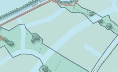
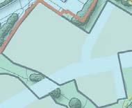
26 Land West of Barrowford - Design and Access Statement The Site and its Context 4 Visual Character of the Site 1 The existing character of the site can be divided into two broad areas: the higher slopes abutting Wheatley Lane Road, and the generally less severe in gradient lower slopes along the south eastern boundary, forming part of the natural floodplain of Pendle Water. A number of dense belts of existing trees and hedges, which form part of the original field boundaries, separate the two areas as well as a steeper sloping bank, restricting views from the bottom of the site looking north west. 2 Vegetation around the boundaries of the site often obscure views out of site with some breaks allowing for attractive views across Nelson and into the surrounding neighbourhood. Careful incoporation of existing assets such as existing vegetation, field boundaries and the sensitive development to the boundaries of the site where views are most prominent, would reduce any adverse affects on the landscape character or features. The opposite images illustrate the current visual character of the site
27
28 5 PROPOSED LAYOUT CONSTRIANTS CONCEPTS BOUNDARIES & ACCESS POINTS GREEN SPINES PRIMARY & SECONDARY ROADS PEDESTRIAN ROUTES DEVELOPMENT AREAS NODES & FOCAL POINTS

29 5 Proposed Introduction Layout Land West of Barrowford - Design and Access Statement Proposed Layout Site Constraints The site will be developed in response to the existing features of the site. The specific features that constrain the development of the site include: Constraints Plan Pendle Hill TOPOGRAPHY The developable area of the site is steeply sloping with general gradients steeper than highway requirements whilst some steeper slopes restrict any development. INFRASTRUCTURE The site is crossed by electricity lines and pylons that will require an easement MATURE TREES Existing mature trees within and adjacent to the site limit the development within their root pretectin areas CONSERVATION AREAS The souh western edge abuts the Carr Hall conservation area and a grade II listed building is located on the same boundary. ECOLOGY Mature trees and hedges within the site may have root protection zones which will restrict development. Existing streams / wetland areas may have ecological value which may need to be protected. Nelson North Site Boundary Conservation Area Existing Woodland / Trees Steepest Slope Ditch / Stream Public Right of Way 15m Easement Zone / Pylon Pendle Water 25


30 Land West of Barrowford - Design and Access Statement Proposed Layout 5 Key Layout Concepts CONCEPT 1 - PEDESTRIAN MOVEMENT CONCEPT 2 - GREEN INFRASTRUCTURE CONCEPT 3 - SENSE OF PLACE AND JOURNEY Pendle Hill Barrowford Carr Hall Conservation o n Area Nelson The proposals will enhance connectivity to the surrounding areas through the creation of a strong pedestrian footpath network within the site, whilst the existing Public Rights of Way which pass through the site will be enhanced by the creation of publically accessible green corridors. The proposed development will integrate existing features, routes and views to create a safe, multifunctional greenspace network within the site. The greenspaces will be designed to ensure that opportunities for informal recreation and ecological enhancement are maximised. The development will provide safe highway access into the site and create an interesting internal journey which will create a strong sense of place, by passing through key nodes which contain existing landscape features. KEY: KEY: KEY: Public Right of Way Pedestrian movement Key Node Pedestrian movement Key Node Green Spine Adjacent locations Public Right of Way Green Spine Public Right of Way Indicative development cell Primary Road 26


31 5 Proposed Layout Land West of Barrowford - Design and Access Statement Boundaries and Access Points Vehicular access into the site will be taken from the A6068 Ring Road via Barrowford Road roundabout. This junction has already been implemented through the development of the Riverside Business Park. An emergency only access point will be provided off Wheatley Lane Road. Pendle Hill The existing boundaries of the site will be enhanced with tree planting, whilst existing vegetation on the east and west boundaries in which PRoW and follow will be improved to create attractive pedestrian movement corridors from Wheatley Lane Road to Barrowford Road. Offsetting development away from the Grade II listed building of Laund Farmhouse will preserve its existing character and setting. Laund Farm house Pendle Water KEY: Site Boundary Views onto external greenspace Key Entrance Enhanced PRoW access point Emergency access only Offset from Grade II Listed Building Laund Farmhouse Barrowford Riverside Business Park North Area of open space Riverside Business park Improved PRoW and green pedestrian corridor Nelson 27


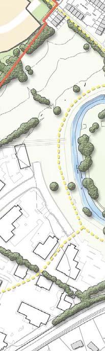
32 Land West of Barrowford - Design and Access Statement Proposed Layout 5 Green Spines Three green corridors will be established in response to the existing site features. Two north west / south east spines follow existing field boundaries to retain existing vegetation, watercourses and ditches. as well as providing the required 40m easement for the electricity pylons which bisect the site. Pendle Hill The south west / north east spine will follow the path of the existing PRoW, retaining an open character along the route and enhancing connectivity to the surrounding areas. The green infrastructure network will be multi-functional, providing spaces for SuDS, amenity, ecology, sports and play, whilst creating an attractive setting for the housing and meeting easement requirements of the elecity pylons. Species rich grassland will make attractive landscape features across the site. Where possible existing hedgerows, ditches and trees will be retained. Laund Farm house Pendle Water KEY: Site Boundary Connections to wider greenspace Proposed Greenspace Riverside Business Park North Existing Trees Key Green Infrastructure spine Nelson 28

33 5 Proposed Introduction Layout Land West of Barrowford - Design and Access Statement Primary and Secondary vehicular routes The primary road network will be designed to create a legible and safe route from south to north at appropriate gradients, whilst capitalising on views towards attractive features within the site and to focal features within the wider landscape. This will enhance local distinctiveness and a help to create a sense of place when navigating the site. Pendle Hill The road network will create a permeable, logical and easily naviagable development that provides direct routes from where people live to where they want to go. It is likely that a secondary and tertiary roads will branch from the primary spine road, and could comprise a mix of narrower streets, shared surface lanes, cul-de-sacs and private drives. This network will define the development blocks and provide access to all areas of the site. The overall intention of the vehicular strategy of the development is to prioritise pedestrian movement over vehicular movement, The detailed design of the road network will seek to minimise hard engineering requirements and follow best practice as described in Manual for Streets 2 Laund Farm house Pendle Water A copy of the detailed proposed highway access plan can be found in Section 6 - Access and Safety. KEY: Site Boundary Riverside Business Park North Spine Road Secondary Road Nelson 29

34 Land West of Barrowford - Design and Access Statement Proposed Introduction Layout 5 Pedestrian Routes Pendle Hill The movement network will be designed to meet the needs of pedestrians and non-vehicular users to discourage unnecessary car usage. Consideration has been given to the location of existing facilities and existing bus stops which will ensure that the movement network responds to the likely direction of travel residents will want to take and so encourage walking and cycling by providing direct, safe, attractive routes to these destinations. New pedestrian routes will be provided throughout the site with enhanced access points to the surrounding pedestrian network. PRoWs that pass through the site will be enhanced and where possible encorporated into the Green Spines, creating attractive pedestrian routes through the site and into the wider area. Laund Farm house Pendle Water KEY: Site Boundary Primary pedestrian route Secondary pedestrian route Riverside Business Park North Spine Road Secondary Road Nelson 30


35 5 Proposed Layout Land West of Barrowford - Design and Access Statement Development Areas Having defined a primary movement network, and green infrastructure, the remaining areas can be considered for development. Pendle Hill E The indicative road network is aligned to provide development blocks which maintain optimum flexibility for future detailed design. The development blocks are designed, where possible, to be capable of having buildings fronting each edge to create active, lively streetscapes with a strong defensible inner core and semi-private frontages that together enhance the security of the scheme as a whole. The layout ensures that all areas of public open space can be overlooked by building frontages. A C D The site will be laid out with all areas of public open space overlooked by building frontages. This will improve the security of these spaces through natural surveillance, enhance the feeling of safety for users, and thereby increase the use of these spaces. RESIDENTIAL DEVELOPMENT AREAS - Area A: 18,428m 42 units / ha = 78 units Area B: 36,866m 40 units / ha = 146 units Area C: 38,490m 45 units / ha = 172 units Area D: 12,293m 46 units / ha = 57 units Area E: 10,651m 44 units / ha = 47 units Laund Farm house B Pendle Water KEY: Total: m units Site Boundary Semi-Private Frontage Riverside Business Park North Development Blocks Proposed Greenspace Nelson 31


36 Land West of Barrowford - Design and Access Statement Proposed Layout 5 Nodes, Focal Points & Views The arrangement of development blocks and open spaces will create a number of key views and spaces within the development. Recognising where these occur enables the development to be designed with a unique character and a sense of place. Pendle Hill Nodes should be created at key points along the movement network These are spaces which have their own sense of character and which can aid orientation and navigation through the development. Nodes will be created by highlighting key route intersections, widening spaces along key routes, placing focal spaces or buildings at the end of view line, or through the use of materials, built form and height. Focal points are proposed throughout the development. These are located to terminate key view lines or to mark important areas within the scheme. Key focal buildings terminate key view lines or mark important areas. Their design should make them stand out from other buildings to help create a sense of local identity and aid navigability through the site. KEY: Laund Farm house Pendle Water Secondary focal buildings respond to other view lines within the Site Boundary movement network by ensuring that these views are terminated Key Landscape Views with attractive buildings rather than blank walls, garages or other less attractive features of the built environment. Key urban views Green spine view Gateway features may be used to frame views and mark the entry to specific areas of the scheme. They may be formed with or without pinch points, use symmetry or strong design features, use houses or smaller built elements or landscape features such as walls or trees. North Node Focal Building Focal Landscape Feature LEAP Riverside Business Park Nelson 32
37
38 6 ACCESS AND SAFETY ACCESS SAFETY AND SECURITY


39 6 Access and Safety Land West of Barrowford - Design and Access Statement Access and Safety Access The scheme will be served from one vehicular access point. The primary access will be from the A6068 to the south of the site, with a secondary emergency / bus service access point from Wheatley Lane Road to the north. Further details regarding the proposed highway access can be found within the Transport Assessment submitted as part of the planning application. The proposed access locations are indicated on the adjacent plans. ROADS AND FOOTPATHS The scheme will provide a comprehensive network of road and pedestrian paths to ensure that all parts of the development are readily accessible to all users. Local re-grading to the existing topography where necessary will allow the provision of all paths to gradients which can be negotiated by the mobility impaired. Proposed highway access Barrowford Road CONSTRUCTION MATERIALS The selection of materials for path surfaces will take into account the needs of all users and the potential to assist in navigation. ENTRY TO BUILDINGS Homes will have level entry routes wherever possible, and approaches to all buildings with public access will be designed for ease of access. Proposed emergency / bus service access from Wheatley Lane Road 35


40 Land West of Barrowford - Design and Access Statement Access and Safety 6 Safety and Security The scheme takes on board the key principles of design for safety as set out in Safer Places, including: ACCESS AND MOVEMENT: well defined routes, spaces and entrances provide for convenient movement without compromising safety; URBAN STRUCTURE: the scheme is planned to ensure that different uses do not conflict; SURVEILLANCE: all publicly accessible spaces are all overlooked by properties and / or vehicular routes; OWNERSHIP: spaces are designed to promote a sense of ownership, respect, territorial responsibility, and community; PHYSICAL PROTECTION: well designed security features, such as lighting in the public realm, and security of buildings will be provided; ACTIVITY: Outdoor public spaces encourages family activity to reduce the risk of crime; MANAGEMENT AND MAINTENANCE: Outdoor public spaces have been designed with management and maintenance in mind; CRIME IMPACT ASSESSMENT: The creation of public realm spaces capable of delivering a scheme which meets each of the aspects of personal safety and security identified above has been taken in to account during the masterplan development. The proposed development will seek to achieve Secured By Design and the details of how this is achieved this will be considered at the Reserved Matters stage. 36
41
42 7 BUILDING SIZE, SCALE & AMOUNT AMOUNT OF DEVELOPMENT AFFORDABLE HOUSING BUILDING SIZE & SCALE
43 7 Building Size, Scale and Amount Land West of Barrowford - Design and Access Statement Building Size, Scale and Amount Amount of Development Building Size and Scale The total site area is 16.93ha / 43.84ac. Based upon the illustrative layout, the breakdown of land uses on the site will be broadly as follows: Greenspace 5.26ha / 13ac Residential development 11.67ha / 28.84ac Affordable Housing Affordable housing will be constructed throughout the development, in a style consistent with other dwellings in the development and of a size commensurate with local need. Details of the affordable housing will be included in the Section 106 Agreement. THE BUILT CONTEXT Existing built development around the site is generally detached and semi-detached two storey domestic dwellings, linked properties, and some three storey apartments. PROPOSED BUILDING SIZE AND SCALE In order to sit comfortably in its surroundings, the development is likely to comprise 2 storey dwellings, with the occasional use of 2.5 storey dwellings, and larger 3 storey dwellings near the south-eastern boundary responding to the building scale of the Riverside Business Park. Houses could be detached, and semi-detached, which may be linked by garages, or short terraces. Approximate dimensions are likely to be as follows: Building height and size parameters (from DPC): 2 storey buildings: Ridge height (from ground): up to 8.5m (max) Eaves height (from ground): up to 5.5m (max) 2.5 storey buildings: Ridge height (from ground): up to 10.5m (max) Eaves height (from ground): up to 5.7m (max) 3 Storey apartment buildings Ridge height from (from ground): up to 11.5m (typical) Ridge height (from ground): up to 12.0m (max) Maximum length of linked properties: 24 metres Maximum depth of linked properties: 10 metres Largest detached unit: 10m x 10m 39


44 Land West of Barrowford - Design and Access Statement Building Size, Scale and Amount 7 KEY 2 Storey Up to 2.5 storey Up to 3 storey / Apartments North 40
45
46 8 ILLUSTRATIVE MASTERPLAN ILLUSTRATIVE MASTERPLAN LAYOUT PROVING DIAGRAM INDICATIVE LEVEL CHANGES
47 8 Introduction Illustrative Masterplan Layout Land West of Laithe Barrowford Farm - Design and Access Statement Illustrative Masterplan Layout The masterplan takes its cue from the existing landscape features both within and around the site: vegetation, landform, views, ecology, drainage and built form. These existing features help to create a unique scheme that is responsive to the site, preserves and enhances the best of what is already there, wherever possible, and knits it into the adjacent areas of open space and urban areas, providing a strong sense of place and local character. The masterplan can accommodate up to 500 dwellings within the site including detached, semi-detached terraced properties and apartments with 2-4 bedrooms and ranging between 2 to 3 storeys tall. The masterplan reflects the design principles explained in the preceding sections and provides one articulation of how the development may be delivered in accordance with these principles. 43

48 Land West of Barrowford - Design and Access Statement Illustrative Masterplan Layout 8 KEY Site Boundary Proposed housing Rear gardens with indicative level change Proposed trees Green spine Retained trees Semi-private open space Existing PRoW Indicitive footpath Laund Farm house Pendle Water Riverside Business Park North 44


49 8 Illustrative Masterplan Layout Land West of Barrowford - Design and Access Statement Proving Diagram The adjacent plan indicatively demonstrates that there is potential to meer a target of 35 units per hectare within this development cell, totalling 137 units, whilst adhearing to the Historic Farmland character area descibed later in this document. More linked units could be incorporated to achieve higher densities. KEY: Private Gardens Semi-Private frontage LOCATION PLAN Private drive Primary / Secondary road SCHEDULE: Detatched 26 Semi-Detatched 58 Linked 26 Apartments 27 Total Area ,855m 2 North Density 35 units / ha 45

50 Land West of Barrowford - Design and Access Statement Illustrative Masterplan Layout 8 Indicative Level Changes 5M REAR GARDEN RETAINING WALLS Level changes highlighting the options available to create appropriate development platforms for the scheme whilst retaining a suitable gradient along the spine road to successfully navigate the length of the site. 3M RETAINING WALLS AND TERRACED GARDENS SPLIT LEVEL DWELLINGS AND RETAINING WALLS 46
51
52 9 APPEARANCE DESIGN PRINCIPALS ARCHITECTURAL QUALITY & STYLE GENERAL CHARACTERISTICS PLACEMAKING
53 9 Appearance Land West of Barrowford - Design and Access Statement Appearance Design Principles Designs should concentrate on creating successful places for people. Building layout and style, hard and soft landscape, highway design and use of materials should all work together to create a cohesive overriding character. These elements must also take account of local context to ensure that the design will fit harmoniously into its surroundings. Architectural Quality and Style The following broad design principles will be adopted throughout the scheme to ensure that the character is coherent: BUILDING MATERIALS AND COLOUR Buildings should reflect the predominant building materials of the nearby traditional and recently built houses around the site. A mixture of brick and some stone should be the primary materials used. The occasional use of rendered facades and architectural detailing may be used to add variety and definition at key locations within the site. Rainwater goods will be either black or coloured to blend with walls. Roof tiles should generally be grey slate effect. Occasional red roof tiles could be used at selective locations to add visual interest and variety. BUILDING LAYOUT Building layout will respond directly to the landscape setting. All pedestrian routes and activity spaces will be overlooked by adjacent properties. Building layout will seek to enhance the sense of place throughout the scheme, creating nodes, vistas and focal buildings. BUILDING STYLE AND FORM It is anticipated that the buildings will comprise a selection of detached, semi-detached and linked properties up to 3 storeys tall with some 3 storey apartment blocks in strategic and appropriate locations. They should be a sensitive interpretation of the traditional building character found around the local area. Elevations should be simple and regular, and varied ridge heights should be a common theme throughout the development to add visual interest. FRONT ENTRANCES Front doors and their surrounds will be given careful consideration to ensure that they establish a high quality feel to the streetscape. The design of doors will vary and will be appropriate to the style of the house. Front boundary treatments will include fencing, low stone and brick walls and hedgerows to replicate the character of the local area. Where rear garden boundaries front onto public realm high quality boundary treatments such as a 1.8m high brick wall should be used to provide a continuous high quality boundary adjacent to public areas. PERSONALISATION The approach to the design of individual units will allow for the possibility of adaptation and personalisation by residents within a well defined framework of consistent building elevations and front boundary treatments. General Defining Characteristics DEFINING URBAN / SPATIAL CHARACTERISTICS Corner buildings should be articulated to define corners and to provide active interfaces on both sides; Access to properties will be via internal spine road and terrtiary roads DEFINING LANDSCAPE CHARACTERISTICS Existing trees to be retained where possible; Amenity grassland and areas directly adjacent to paths kept mown; Embankments to be sown and maintained as species rich grassland; Footpaths to be surfaced with appropriate bound aggregate and provide connection to existing PRoW network 49


54 Land West of Barrowford - Design and Access Statement Appearance 9 Placemaking The indicative layout proposes different places within the site which will result from the way that the buildings frame different parts of the public realm i.e. greenspaces, streets and mews. These places reflect the principles of the indicative layout and are not fixed. The indicative layout includes the following broad character areas: WHEATLEY LANE ROAD HISTORIC FARMLAND BARROWFORD ROAD GATEWAY MIDDLE SLOPES NORTH EAST SLOPES The proposed character areas create a logical change in character through the scheme which will fit comfortably into the surrounding area and help to establish a strong sense of place. The character areas take their cue from their location within the scheme and from the areas they abut. The boundaries to the character areas should not be seen as fixed; it may be appropriate for them to blend into one another. The following pages give a brief flavour of the distinguishing features of the character areas, however the guidance is not intended to be exhaustive or wholly prescriptive. It is intended to set out the character North that is envisaged, and which should be taken forward as the scheme is developed through the reserved matters stage. 50

55 9 Appearance Land West of Barrowford - Design and Access Statement The North East Slopes Character Area Defining characteristics This character area is generally informed by the more formal arrangement of housing to the north eastern boundary of the site including Warren Drive and Dixon Street. Garden boundary treatments in this area will reflect adjacent treatments with more formal vegetated boundaries and low brick walls. Built form will be primarily semi-detatched and linked properties, positioned to create semi-private courtyards along the road or facing onto enclosed greenspace creating visually interesting nodes as people move through the area and reinforcing a sense of journey. Variations in building line and ridge heights should provide visual interest. DEFINING URBAN / SPATIAL CHARACTERISTICS Building scale should primarily be 2.5 / 3 storey properties with some apartment buildings in strategic locations; Overall density higher than other character areas, responding to the high density of the existing housing adjacent to the north-eastern boundary on Warren Drive and Dixon Street; Predominantly linked, semi-detached or apartment properties More formal building arrangement active towards roads to create a strong, enclosed street frontage / corridor along spine road simialar to that of the existing housing adjacent to character area. The amenity greenspace and PRoW that bisects the character area will provide an attractive setting for both informal and formal recreation. A Locally Equipped Area for Play will be provided in this space, overlooked by properties to enhance the security of the space. The PRoW that runs along the north-eastern boundary, linking Wheatley Lane Road and Pendle Water should be enhanced with new tree and hedge planting to create an attractive north-west to south-east green movement corridor. Where possible parking will be positioned discretely, however street parking should also form some integral component of this character area, contributing to the vitality of the scheme, bringing movement and people onto the street. DEFINING LANDSCAPE CHARACTERISTICS Amenity green space and LEAP established in central area of development cell to create focal open space for residents; Front boundary treatment mix of brick and vegetated boundaries in keeping with boundaries of housing adjacent to site; Where buildings front directly onto the street, level hard surfaced open frontages may be appropriate - a change in surface material should clearly delineate the public / private threshold; Street trees planted along primary road to create hierarchy of streets; Formal tree arrangement in tree grills where necessary; Street tree planting: suggested tree species to include: Hornbeam Lime, Birch and Cherry; Existing trees to be retained where possible; Amenity grassland and areas directly adjacent to paths kept mown; Embankments to be sown and maintained as species rich grassland; Footpaths to be surfaced with appropriate bound aggregate. 51


56 Land West of Barrowford - Design and Access Statement Appearance 9 Enhanced connectivity to existing PRoW network Courtyards to be pedestrian friendly hard paved shared surfaced areas with subtlety delineated footways and parking areas Amenity greenspace and LEAP framed by development to create a focal open space for residents and increase security. Street character links to Warren Drive. Rear gardens face out onto open fields and attractive views of Pendle Water and surrounding neighbourhood North 52

57 9 Appearance Land West of Barrowford - Design and Access Statement The Historic Farmland Character Area Defining characteristics The western edge of the site will have a character that is sensitive to the adjacent conservation area and Laund Farm House. The site layout incorporates expanses of open space in this location which together with low density housing will create an open, green character. Houses will exhibit a traditional appearance based on the local vernacular. Built form should be predominantly detached, with views onto the Carr Hall conservation area and the green spine where possible. The placement of housing should reflect a more rural character, softening the impact of the development on the surrounding area. Boundary treatments could reflect the existing boundaries through the use of soft vegetation and low stone walls. Properties within the character area facing onto the spine road could be of a higher density and predominantly semi-detached / linked units. Where possible, on-plot parking will be discretely positioned between houses to reduce the visual impact of on street parking and retain a more open and rural character. The buffer zone around Laund Farmhouse in which the existing PRoW passes through will open up the area to create attractive views out of the site, as well as helping to retain the rural character of Laund Farmhouse. DEFINING URBAN / SPATIAL CHARACTERISTICS Building scale should primarily be 2 storeys with some 2.5 storey units in keeping with the scale of surrounding buildings such as Laund Farmhouse; Generally low density with an open feel around the boundaries of the site, with an overall density higher along the spine road corridor; Frontages generally set back towards greenspace and primary road corridor; Generally detached properties along boundaries of character area where it is possible for units to face onto open greenspace, with some semi-detached or linked units situated within the character area. DEFINING LANDSCAPE CHARACTERISTICS Front boundary treatment: informal, low stone walls and soft vegetated boundaries to tie in with surrounding boundary treatments in keeping with historic farmland character; Existing hedgerows to be appropriately managed and supplemented with new native hedgerow planting - suggested species to include: Blackthorn, Hawthorn and Hazel; Tree planting arranged informally as individual specimens or groups, framing key views where possible; Native tree planting: suggested species to include: Oak, Wild Cherry, Hawthorn and Field Maple; Existing trees to be retained where possible; Amenity grassland and areas directly adjacent to paths kept mown; Embankments to be sown and maintained as species rich grassland; Footpaths to be surfaced with appropriate bound aggregate. 53


58 Land West of Barrowford - Design and Access Statement Appearance 9 Enclosed spaces increasing privacy and security Green corridor created along existing PRoW Spaces to be pedestrian friendly hard paved shared surfaced areas with subtlety delineated footways and parking areas Offset from Laund Farmhouse creates attractive setting for Grade II listed building Existing field boundaries retained to create strong sense of character and link to historic farmland North Attractive views out of site onto Carr Hall conservation area. 54

59 9 Appearance Land West of Barrowford - Design and Access Statement The Middle Slopes Character Area Defining characteristics The Middle Slopes character area should aim to reflect the rural quality of the historic farmland, and blend it into a more urban and formal arrangement of buildings of the north east slopes, providing a transition and bridge between the two character areas. Built form should be predominantly semi-detached or linked properties and be at a higher density than the rural character area of the Historic Farmland. Properties where possible should face onto the green spines which make up a large portion of this character area. Bounded on one edge by the north west to south east greenspine, the amenity greenspace will provide opportunities for informal and formal recreation. DEFINING URBAN / SPATIAL CHARACTERISTICS Building scale should primarily be 2 / 2.5 storey units; Primarily semi-detached and linked properties facing onto the spine road, with some apartments located at key locations reflective of the scale and size of adajecent farm buildings; Overall density higher along the road corridor; Frontages generally set back and active towards primary road corridor and green spines; Semi-formal building arrangement to create a strong, enclosed street frontage / corridor. Properties within this character area that face onto the primary spine road will be set back from road, with parking located discretely between houses to reflect a more open and rural feel. Gateway feature buildings should be used to create pinch points, frame views and define the transitional areas between development cell and greenspine to create visual interest and a strong sense of journey, with the enclosed areas of housing along the spine road opening out to attractive views onto the greenspine, Pendle Water and across Nelson. DEFINING LANDSCAPE CHARACTERISTICS Amenity greenspace focused within greenspines, provding expansive views across local area; Front boundary treatment: formal, low stone walls or hedgerows in keeping with Wheatley Lane Road boundary treatments. Street trees planted along primary road to create hierarchy of streets; Existing hedgerows to be appropriately managed and supplemented with new native hedgerow planting - suggested species to include: Blackthorn, Hawthorn and Hazel; Native tree planting: suggested species to include: Oak, Field Maple in open areas in informal groups, with Lime and Cherry used to delineate primary roads; Existing trees to be retained where possible; Amenity grassland and areas directly adjacent to paths kept mown; Embankments to be sown and maintained as species rich grassland; Footpaths through green corridor to be surfaced with rolled stone. 55


60 Land West of Barrowford - Design and Access Statement Appearance 9 Strengthened links to existing PRoW network Footpaths through greenspace with views over site and surrounding area Spine Road weaves in and out of built development and greenspines to create visual interest and strong sense of journey. Gateway buildings used to frame views into development areas North 56

61 9 Appearance Land West of Barrowford - Design and Access Statement The Wheatley Lane Road Character Area The northern part of the site will be developed at a lower density to respect the undeveloped rural character to the north, properties will front onto Wheatley Lane Road where possible and will be arranged in irregular and informal groupings reminiscent of the massing of farm buildings. Properties should be 2 storey detached properties, following the line of existing properties along Wheatley Lane Road on the north-western boundary of the site, allowing the new development to tie in with existing form and sit comfortably within the urban framework whilst also captialising on the views across an Area of Outstanding Natural Beauty and Pendle Hill. The greenspine in this character area fronts onto Wheatley lane road, allowing existing residents access to the new north-west to south-east connection. Defining characteristics DEFINING URBAN / SPATIAL CHARACTERISTICS Building scale should be 2.5 storey maximum to tie in with existing properties on Wheatley lane road. Generally semi-detached or detached units Corner buildings should be articulated to define corners and to provide active interfaces on both sides; Frontages generally set back and active towards Wheatley Lane Road Access to properties should be to the rear via the internal spine road. DEFINING LANDSCAPE CHARACTERISTICS Property boundaries should be a continuation of the boundaries already in place with low brick or stone walls, with some formal hedge boundaries Street trees planted along primary road to create hierarchy of streets; Street tree planting: suggested tree species to include: Hornbeam Lime, Birch and Cherry; Existing trees to be retained where possible; Amenity grassland and areas directly adjacent to paths kept mown; Embankments to be sown and maintained as species rich grassland; Footpaths to be surfaced with appropriate bound aggregate and provide connection to existing PRoW in Clayton Wood. 57


62 Land West of Barrowford - Design and Access Statement Appearance 9 Offset housing from main road softens the development edge Properties facing Wheatley Lane Road in keeping with existing vernacular Green spine connects to site boundary, maintaining ecological green infrastructure link to wider Landscape. Emergency only access point North 58
63 9 Appearance Land West of Barrowford - Design and Access Statement The Barrowford Road Character Area The Barrowford Road character area should be respond to the scale and more formal nature of the existing Riverside Business Park, with some 3 storey buildings and linked properties facing onto the primary entrance road. Properties facing Riverside Business Park will have vehicular access discretely positioned to the rear to create an attractive car free facade to the boundary of the site. Formal tree planting could delineate and define the access road into the site, whilst also creating an attractive movement corridor on the approach to the main access point. Defining characteristics DEFINING URBAN / SPATIAL CHARACTERISTICS Building scale should primarily be 2.5 storey Generally detatched or semi-detatched properties within the core and along primary spine road, with larger 3 storey and linked properties along southern edge of character area mirroring the building scale of the Riverside Business Park. Overall density higher along the road corridor; Corner buildings should be articulated to define corners and to provide active interfaces on both sides; Frontages generally set back with access to properties to the rear or on street parking DEFINING LANDSCAPE CHARACTERISTICS Views from entrance into site enhanced with open space and feature buildings. Front boundary treatment should be low vegetation or open to compliment the surrounding boundaries of Parrock Road as well as creating an open and rural quality to the space. Street trees planted along primary spine road and entrance road to create hierarchy of streets and delieneate entrance route; Street tree planting: suggested tree species to include: Hornbeam Lime, Birch and Cherry; Existing trees to be retained where possible; Amenity grassland and areas directly adjacent to paths kept mown; Embankments to be sown and maintained as species rich grassland; Footpaths to be surfaced with appropriate bound aggregate and provide connection to existing PRoW bisecting sourthern corner of character area. 59


64 Land West of Barrowford - Design and Access Statement Appearance 9 Attractive views into site of feature building and tree planting from entrance 3 storey apartment buildings respond to building scale of adjacent Riverside Business park North Housing facing onto existing PRoW enhances security and provides attractive setting for units Formal street trees help to delineate access route into site 60
65
66 10 INDICATIVE PHASING


67 10 Indicative Phasing Land West of Barrowford - Design and Access Statement Indicative Phasing The adjacent plan provides an indication of how the development is expected to be phased. Each phase could be expected to take up to 3 years subject to build rates and market conditions. The individual phases of development have been defined by the broad level changes identified during the site analysis stage and the route of the spine road. Whilst at outline stage development phases can only be estimated, the phasing programme is considered at this time to be realistic and achievable. KEY: Phase 1 Phase 2a Phase 2b Phase 3 North 63
8.0 Design and Form of Development 43/
 42/ 8.0 Design and Form of Development 43/ Rothwells Farm, Golborne/ Development Statement Figure 7. Site Constraints Key 44/ Site Boundary 360 Bus Route/Stops Existing Trees Underground Water Pipe Sensitive
WELCOME. Land North of STEVENAGE. We would like to thank you for attending our public exhibition today.
 WELCOME We would like to thank you for attending our public exhibition today. The purpose of this event is to share our proposals and hear your thoughts on our ideas. Members of the project team are on
Public Consultation. Land at Monks Farm, North Grove. Welcome
 Welcome Welcome to our public exhibition for development on Land at Monks Farm, orth Grove. Gallagher Estates and Gleeson Strategic Land are preparing an outline planning application for new homes, open
WELCOME GYPSY LANE. Wider Site Location plan. Proposals for the development of LAND OFF FOXLYDIATE LANE WEBHEATH. Proposals for the development of
 WELCOME The developers are preparing an outline planning application for a residential led development and need the community s views in order to develop the proposals further WHAT IS PROPOSED? A high
Newcourt Masterplan. November Exeter Local Development Framework
 Newcourt Masterplan November 2010 Exeter Local Development Framework Background The Exeter Core Strategy Proposed Submission sets out the vision, objectives and strategy for the development of Exeter up
Chapter 2: OUTLINE PLANNING APPLICATION PROPOSALS. A New Garden Neighbourhood Matford Barton 17
 Chapter 2: OUTLINE PLANNING APPLICATION PROPOSALS A New Garden Neighbourhood Matford Barton 17 2.1. SUMMARY AND STATUS OF THE PROPOSALS 2.1.1. The parameter plans and associated wording in this chapter
Site ref: AS06 Site Name or Address: Murreys Court, Agates Lane
 Site ref: AS06 Site Name or Address: Murreys Court, Agates Lane Proposed Land Use: Total Site Area (Ha): Housing 1.85 Ha Description: It is understood that the owner has no plans to dispose of the site
INTRODUCTION. Land south of Bishopswood Lane, Tadley
 0 INTRODUCTION THE SITE Introduction Gladman Developments Ltd. has successfully invested in communities throughout the UK over the past 0 years, developing high quality and sustainable residential, commercial
Schedule of Planning Applications Committee Date: 23 May Reference: 06/17/0726/F Parish: Hemsby Officer: Mr J Beck Expiry Date:
 Schedule of Planning Applications Committee Date: 23 May 2018 Reference: 06/17/0726/F Parish: Hemsby Officer: Mr J Beck Expiry Date: 22-05-2018 Applicant: Proposal: Site: Mr Gillett Change of use to the
PHASE III: Reserved Matters Submission
 Statement of Compliance with the outline approval for the proposed residential development of land at: BURGES LANE, WIVELISCOMBE PHASE III: Reserved Matters Submission Foreword Contents: This Statement
3.1 The hybrid planning application proposes the following description of development:
 CHAPTER 3: PROPOSED DEVELOPMENT 3.1 The hybrid planning application proposes the following description of development: Hybrid (part-outline/part-full) planning application for a single composite development
Welcome to our exhibition
 Welcome to our exhibition The Homes & Communities Agency (HCA) welcomes you to this public exhibition explaining our proposals for the redevelopment of the former Lea Castle Hospital site. About the Homes
SOUTH EAST LINCOLNSHIRE LOCAL PLAN: HOUSING PAPER DONINGTON (JUNE 2016)
") SOUTH EAST LINCOLNSHIRE LOCAL PLAN: HOUSING PAPER DONINGTON (JUNE 2016) 1 DONINGTON S PLACE IN THE SPATIAL STRATEGY 1.1 Policy 2 of the South East Lincolnshire Local Plan 2011-2036 Draft for Public Consultation
SOUTH EAST LINCOLNSHIRE LOCAL PLAN: HOUSING PAPER DONINGTON (JUNE 2016) 1 DONINGTON S PLACE IN THE SPATIAL STRATEGY 1.1 Policy 2 of the South East Lincolnshire Local Plan 2011-2036 Draft for Public Consultation
Land East of Cromwell Lane
 Land East of Cromwell Lane VISION DOCUMENT AUGUST 2016 The proposals for Land East of Cromwell Lane will be defined by existing landscape features, ensuring that the development offers a quality place
PDP DESIGN & ACCESS STATEMENT
 PDP The Planning & Design Partnership Planning.. Architecture.. Interiors.. Landscape The Chicory Barn Studio, The Old Brickyards, Moor Lane, Stamford Bridge York, The East Riding Of Yorkshire, YO41 1HU.
Rochford District Council Allocations Development Plan Document: Discussion and Consultation Document Sustainability Appraisal
 Option SWH1 Balanced Communities Option SWH1 1 To ensure the delivery of high quality sustainable communities where people want to live and work Will it ensure the phasing of infrastructure, including
University Park, Worcester Non Technical Summary December 2011
 University Park, Worcester Non Technical Summary December 2011 Introduction UW Wrenbridge LLP, a Joint Venture Company of the University of Worcester and Wrenbridge Land Ltd (the Applicants ) intend to
BLETCHLEY PARK AREA - DEVELOPMENT FRAMEWORK
 ANNEX A To Item 9 REVISED TEXT: additions shown bold and underlined, deletions in (brackets and in italics). BLETCHLEY PARK AREA - DEVELOPMENT FRAMEWORK This framework sets out the key objectives and requirements
Welcome to our public exhibition
 About Our Scheme Welcome to our public exhibition This exhibition gives you the chance to view and comment upon our emerging proposals for a new residential development of 68 new homes on the site of the
Statement of Community Involvement LAND OFF SOUTHDOWN ROAD HORNDEAN, HAMPSHIRE
 LAND OFF SOUTHDOWN ROAD HORNDEAN, HAMPSHIRE CONTENTS Page 1. Introduction 3 2. Pre-application Discussions 4 3. The Consultation Process 5 4. Consultation Feedback 7 5. Responses to Consultation Feedback
DESIGN & ACCESS STATEMENT
 DESIGN & ACCESS STATEMENT January 2016 Contents Introduction section 1 Section 1 - Introduction Section 2 - Assessment Section 3 - Involvement Section 4 - Evaluation Section 5 - Design Section 6 - Layout
WELCOME. North East Haverhill. The Planning Process
 WELCOME North East The site to the North East of, known as Great Wilsey Park, is identified by St Edmundsbury Borough Council in its Core Strategy as capable of delivering a Sustainable Urban Extension.
Kibworth Harcourt. Introduction. Introduction
 Introduction Introduction Welcome to this public exhibition on the proposals for the delivery of new homes on land at The Kibworths. The purpose of today s exhibition is to give you the opportunity to
Copyright Nigel Deeley and licensed for reuse under this Creative Commons Licence
 1 Copyright Nigel Deeley and licensed for reuse under this Creative Commons Licence Prepared by the Neighbourhood Plan Steering Group on behalf of Garway Parish Council with assistance from 2 Table of
Welcome to our public exhibition
 About our development Welcome to our public exhibition This exhibition gives you the chance to view and comment on our proposals for a new residential development of 165 high-quality homes, along with
Site north of Hattersley Road West (east of Fields Farm Road), Hattersley
, Hattersley") Application Number 17/00982/REM Proposal Site Applicant Recommendation Reason for report Application for the approval of reserved matters (means of access, landscaping, layout, scale and appearance) relating
Application Number 17/00982/REM Proposal Site Applicant Recommendation Reason for report Application for the approval of reserved matters (means of access, landscaping, layout, scale and appearance) relating
Housing Development at Balloonagh Tralee Co Kerry
 Design Statement Housing Development at Balloonagh Tralee Co Kerry Area of site 10,400m2 24 houses-12no 3 bed, 12no 2 bed and 4 single bed apartments total residential area of 2411m2 Open space provided
WHITELEY TOWN COUNCIL NORTH WHITELEY DEVELOPMENT SEPTEMBER 2014
 WHITELEY TOWN COUNCIL NORTH WHITELEY DEVELOPMENT SEPTEMBER 2014 Dear Resident This Special Edition of the Whiteley Voice which has been prepared in conjunction with the North Whiteley Consortium is to
Former North Works, Lickey Road, Longbridge, Birmingham
 Committee Date: 14/11/2013 Application Number: 2013/06431/PA Accepted: 27/08/2013 Application Type: Full Planning Target Date: 26/11/2013 Ward: Longbridge Former North Works, Lickey Road, Longbridge, Birmingham
Planning and Sustainability Statement
 Land adjacent to Manor Farm, Catterick Village Pallett Hill Sand and Gravel Co Ltd Proposed 10 new dwellings, (6 No market dwellings and 4 No affordable dwellings) with access, associated car parking and
Sustainability Statement. Whitby Business Park Area Action Plan
 Sustainability Statement Whitby Business Park Area Action Plan November 2014 Contents Page 1. Introduction 1 2. Scoping 3 3. Sustainability Appraisal of Options 6 4. Assessment of Draft Area Action Plan
LONGDEN VILLAGE DEVELOPMENT STATEMENT
 LONGDEN VILLAGE DEVELOPMENT STATEMENT 2017-2027 1 Longden Development Statement 2017-2027 15/01/18 1. Background 1.1 Longden Village Longden village is a very rural and traditional community first mentioned
Carterton Construction Ltd is bringing forward plans for up to 85 new family homes and extra care facilities on land east of Burford.
 Welcome Carterton Construction Ltd is bringing forward plans for up to 85 new family homes and extra care facilities on land east of. We are at the early stages of designing our proposals and have a number
SITE ASSESSMENT CHECKLIST
 1. Site Details a. What is the site s name/reference? SITE ASSESSMENT CHECKLIST CR3NPWHY 3007 Gasometer Site Godstone Road CR3 0EG b. Where is the site located? Wyhteleafe; Godstone Road. Urban category1
INTRODUCTION NORTH HEYBRIDGE GARDEN SUBURB
 INTRODUCTION This event is being hosted by the promoters of the proposed North Heybridge Garden Suburb who are working with Maldon District Council and other key stakeholders on the preparation of a comprehensive
CALA HO ME S WELCOME
 WELCOME Welcome to this public consultation event for our proposed residential development of 56 high quality homes on land to the north east of Station Road in Earls Colne. Thank you for taking the time
Welcome to our Public Consultation
 About our development This exhibition gives you the chance to view and comment on our emerging plans for a proposed residential development located on land to the West of Alwyn Road, Rugby. Welcome to
Watford Local Plan Part 2 Publication Stage Environmental Report. Appendix 3: Consultation Comments
 Watford Local Plan Part 2 Publication Stage Environmental Report Appendix 3: Consultation Comments August 2016 Appendix 3 - Responses to Consultation of the Local Plan Part 2 As required by the SEA Directive,
Colchester Northern Gateway Master Plan Vision Review Draft. July 2016
 Colchester Northern Gateway Master Plan Vision Review Draft July 2016 Contents Introduction 4 Context 8 Purpose of the Report 8 Strategic Position 9 Overview of the Process 11 2012 Master Plan Vision 12
SPG 1. * the northern and western sections which are open fields used for pasture and grazing;
 SPG 1 1.0 INTRODUCTION This development brief is based on the allocation of the Priors Hall site for employment and countryside recreational purposes in the Corby Borough Local Plan. The brief is intended
WELCOME. Olney Road, Lavendon INTRODUCTION. The Site. The Application. The Need for Housing. A Sustainable Location LAVENDON TURVEY OLNEY ROAD
 0 WELCOME INTRODUCTION Gladman Developments Ltd have successfully invested in communities throughout the UK over the past 0 years, developing high quality and sustainable residential, commercial and industrial
Derry City and Strabane District Council Planning Committee Report
 Derry City and Strabane District Council Planning Committee Report COMMITTEE DATE: 23 rd March 2016 APPLICATION No: APPLICATION TYPE: PROPOSAL: LOCATION: APPLICANT: LA11/2015/0395/F Residential Development
Welcome to our exhibition
 Welcome to our exhibition housing development A46 Wildmoor Alcester Road Canal Quarter A422 Town Centre housing development Warwickshire-based IM Properties, one of the UK s largest privately owned property
Development of land adjacent to Braggs Farm Lane and Rumbush Lane, Dickens Heath. Welcome. Today s exhibition. The proposal site
 Welcome Welcome to this event to discuss the development of land adjacent to Braggs Farm Lane. is currently in the preliminary stages of designing proposals to sensitively develop this site with high-quality
Introduction. Welcome to this consultation regarding the draft redevelopment proposals for the former CeramTec factory on Sidmouth Road, Colyton.
 Introduction Welcome to this consultation regarding the draft redevelopment proposals for the former CeramTec factory on Sidmouth Road, Colyton. We are currently considering options for the mixed-use redevelopment
Neighbourhood Planning Local Green Spaces
 Neighbourhood Planning Local Green Spaces Introduction... 2 1. Why green space is important... 4 2. Neighbourhood plans and green space... 6 3. Evidence... 8 Statutory designations... 9 Green space audit...
PROPOSED RESIDENTIAL DEVELOPMENT LAND AT GREEN LANE, YARM
 PROPOSED RESIDENTIAL DEVELOPMENT LAND AT GREEN LANE, YARM PUBLIC CONSULTATION YOUR VIEW MATTERS TO US LOCATION PLAN Thank you for taking the time to read this information leaflet regarding a proposed residential
Urban Design Guidelines
 Urban Design Guidelines These Urban Design Guidelines comprise the Key Design Objectives below, the Roads Design Guidelines overleaf and Neighbourhood Framework Plans. Together with Section 3: Urban Design
Elderberry Walk. Developer HAB Housing
 Case studies Elderberry Walk Developer HAB Housing Development of 161 new homes on the former Dunmail Primary School site, focused around a central green street, with retained trees, new multifunctional
DUNSFOLD NEIGHBOURHOOD PLAN Site Selection Policies
 DUNSFOLD NEIGHBOURHOOD PLAN Site Selection Policies The criteria for assessing sites for future housing and business development in Dunsfold are set out below. (Development criteria, covering what it is
Land at Rampton Road. Cottenham
 Land at Rampton Road Cottenham Introduction TEP is preparing an outline planning application for 54 dwellings on 6.9 hectares of land adjacent to Rampton Road, Cottenham on behalf of the owners Cambridgeshire
Public Consultation 23 January Peel Hall, Warrington Board 1. A message from Satnam... Site history...
 Board 1 A message from Satnam... Thank you for attending today s public consultation about proposals to develop a new residential neighbourhood at. The display boards show why the development is needed
2.0 Strategic Context 4
 2.0 Strategic Context 4 2.1 The Area Action Plan is a non-statutory plan, which forms a corporate policy document, expressing particular issues and areas of concern while also providing a vision for the
Complete Neighbourhood Guidelines Review Tool
 Complete Neighbourhood Guidelines Review Tool Prepared By: City of Regina Planning Department October 2014 Page 1 of 14 Community Development Review Checklist for Secondary Plans and Concept Plans The
DESIGN & ACCESS STATEMENT
 DESIGN & ACCESS STATEMENT Land to the South East of the A495, Bronington Erection of 31 Dwellings (27 dwellings and 4 bungalows including 4 Affordable Dwellings), Realignment and Improvements to A495 (including
Application and Proposals. Part 211
 Application and Proposals Part 211 Site Location and Context The application site comprises two distinct land parcels totalling some 135 hectares. The site is bisected eastwest by Churchlands Development.
Alder View. Introduction. Alder View. Harwell. The Vision. The Team. Taylor Wimpey
 Introduction Welcome to the public exhibition for, a development by Taylor Wimpey on the land south of Grove Road,. This exhibition will provide an overview of the development proposals for the site and
The journey so far. The new masterplan for Dargavel Village
 The journey so far Our vision for Dargavel Village began over ten years ago when the original masterplan for transforming the former Royal Ordnance Factory site into a thriving community was established.
Ashtead Neighbourhood Forum Site Assessment AS03 Lime Tree Lodge, Farm Lane. Site address: Lime Tree Lodge, Farm Lane. Proposed Land Use:
 Site ref: AS03 Site address: Lime Tree Lodge, Farm Lane Proposed Land Use: Total Site Area (Ha): Housing 1.25ha Description The site is located off Farm Lane at the junction with Park Lane. To the north
Frequently Asked Questions
 1. Where is Aylesbury Woodlands? Frequently Asked Questions Aylesbury Woodlands lies to the east of Aylesbury. It is bounded to the south by the A41. To the north is the Aylesbury Arm of the Grand Union
INTRODUCTION. Land West of Main Road, Stanton Harcourt THE SITE. Why is the Site Suitable for Development?
 0 INTRODUCTION THE SITE Application Boundary Gladman Developments Ltd has successfully invested in communities throughout the UK over the past 0 years, developing high quality and sustainable residential,
Land at BROOK STREET PROPERTIES TENCREEK FARM, LISKEARD. Environmental Statement: Non-Technical Summary
 BROOK STREET PROPERTIES TENCREEK FARM, LISKEARD Land at Environmental Statement: Non-Technical Summary Introduction Brook Street Properties is applying to Cornwall Council for outline planning permission
Background Information
 Background Information view at site entrance THE LONDON BOROUGH OF SUTTON As the strategic local authority the Council is working with a range of partners to take forward various development sites in Hackbridge.
Welcome. Site/11/04. Site/11/03. Proposed Site. 11,400 new homes needed in east Cambs
 Welcome Welcome to our consultation on our proposals for new homes on land north east of Soham Road, Fordham. Members of the project team are available to answer any questions you have and listen to feedback.
Welcome to our public exhibition
 About our scheme Welcome to our public exhibition Taylor Wimpey East Anglia intends to submit a detailed planning application for a new residential development of 39 high-quality homes at the B&M Concrete
Woodbrook - Shanganagh
 Section 4: Key Sites Framework Strategy Woodbrook - Shanganagh Local Area Plan 2017-2023 4. Site Framework Strategies The Master Plans shall have regard to the thematic objectives under the LAP Development
The Fairfield Partnership Vision for North-East Elsenham
 The Fairfield Partnership Vision for North-East Elsenham August 2009 Frequently Asked Questions Who is The Fairfield Partnership? The Fairfield Partnership is a joint venture between Marchfield Developments
Welcome. Proposals for land at Smug Oak Lane BRICKET WOOD
 Proposals for land at Smug Oak Lane BRICKET WOOD Previous Linden Homes and Wates Developments scheme Welcome Welcome to Linden Homes and Wates Developments public exhibition. Working together as joint
Story Homes. Land at Thirsk Road, Kirklevington. An Introduction to Story Homes. Our Foundations. Commitment to Consultation.
 Story Homes An Introduction to Story Homes Founded by Fred Story in 1987, Story Homes has a long and successful reputation of building high quality and high specification homes. The family owned business
Former Temple Cowley Pools, Oxford TEMPLE COWLEY LIBRARY * ELEVATION SHOWN IS INDICATIVE AND SUBJECT TO FINAL DESIGN AND AGREEMENT.
 OPEN SPACE TEMPLE COWLEY LIBRARY library beyond Proposed apartments Proposed apartments Proposed houses Temple Road * ELEVATION SHOWN IS INDICATIVE AND SUBJECT TO FINAL DESIGN AND AGREEMENT. * Welcome
Droitwich Spa 6. Reasoned Justification
 87 Droitwich Spa 6 Reasoned Justification 6.1 Droitwich Spa is identified in the settlement hierarchy (Policy SWDP1) as a main town being the largest settlement in Wychavon District with an estimated population
Ashtead Neighbourhood Forum Site Assessment AS07 Old Chalk Pit, Pleasure Pit Road. Site ref: AS07 Site address: Old Chalk Pit, Pleasure Pit Road
 Site ref: AS07 Site address: Old Chalk Pit, Pleasure Pit Road Proposed Land Use: Total Site Area (Ha): Housing 0.7ha Description: The site was formally an old chalk pit that has been partially filled and
FORMER CANADIAN FORCES BASE (CFB) ROCKCLIFFE SECONDARY PLAN. Official Plan Amendment XX to the Official Plan for the City of Ottawa
 ROCKCLIFFE SECONDARY PLAN. Official Plan Amendment XX to the Official Plan for the City of Ottawa") FORMER CANADIAN FORCES BASE (CFB) ROCKCLIFFE SECONDARY PLAN Official Plan Amendment XX to the Official Plan for the City of Ottawa 1 INDEX THE STATEMENT OF COMPONENTS PART A THE PREAMBLE PAGE Purpose...
FORMER CANADIAN FORCES BASE (CFB) ROCKCLIFFE SECONDARY PLAN Official Plan Amendment XX to the Official Plan for the City of Ottawa 1 INDEX THE STATEMENT OF COMPONENTS PART A THE PREAMBLE PAGE Purpose...
Rotherhithe Rotherhithe Area Vision Map
 Area Vision Map CWAAP1 Improved pedestrian and cycle links to the wider area Improved link from town centre to River Thames and docks CWAAP2 Brunel Museum NSP79 CWAAP3 Proposed Thames Crossing Station
Environmental and Landscape Mapping
 Environmental and Landscape Mapping In support of the Calveley Neighbourhood Plan November 2016 Project Name and Number: Calveley Neighbourhood Plan 16-025 Document Name and Revision: Environmental and
3. Neighbourhood Plans and Strategic Environmental Assessment
 1. Introduction This report sets out a draft Screening Determination for the Preston Parish Council s Neighbourhood Plan and has been prepared by rth Hertfordshire District Council. The purpose of the
Neighbourhood Planning Site Assessment Pro-forma and Guide Version 2
 Neighbourhood Planning Site Assessment Pro-forma and Guide Version 2 September 2014 Site HNP 006 Land East of Stanbridge Road and North of Lower Road 1. Background information Site location and use Site
01 Welcome. Why are we here?
 01 Welcome Why are we here? In July 2014 GreenSquare unveiled its plans for 1500 homes to the local community providing much needed houses during the first half of the Stroud District Local Plan period.
10. East Dulwich East Dulwich Area Vision
 10. 10.1. Area Vision 10.1.1. is: A predominantly residential area characterised by mostly medium density housing, including many family homes. Many parts of have retained historic character and it includes
Camberwell Camberwell Area Vision Map
 Area Vision Map NSP23 Burgess Park Edmund Street NSP29 NSP30 NSP31 New Road Benhill Road NSP27 NSP33 Green Brunswick Park NSP22 station NSP24 Peckham Road NSP26 St Giles Church Lucas Gardens NSP28 NSP25
Parish of Repton NEIGHBOURHOOD DEVELOPMENT PLAN
 Parish of Repton NEIGHBOURHOOD DEVELOPMENT PLAN BASIC CONDITIONS STATEMENT December 2018 CEF 4 Legal Requirements This statement has been produced by the NDP Working Group on behalf of Repton Parish Council
Page 1 of 19 URBAN DESIGN FRAMEWORK FOR BOLTON STREET WATERFORD
 Page 1 of 19 URBAN DESIGN FRAMEWORK FOR BOLTON STREET WATERFORD 1.0 Introduction: The relocation of the City Council stores and depot from Bolton Street creates an exciting opportunity for development
CAERNARFON DEPENDENCY CATCHMENT AREA
 CAERNARFON DEPENDENCY CATCHMENT AREA GWYNEDD UNITARY DEVELOPMENT PLAN - HOUSING Map not to scale Dependency Catchment Area Location 2 Caernarfon Topic Housing To the rear of Bro Eglwys, Bethel. Grid Ref.
NORTH WEST SECTOR HORLEY, SURREY
 Welcome to our Exhibition We are delighted to present our plans for the first phase of the North-West Sector Horley development. We are holding this exhibition to give you the chance to view and comment
Mortimer NDP, Principles, Vision and Policies
 The Three Principles Mortimer NDP, Principles, Vision and Policies 1. The NDP must make it possible for people to live the whole of their lives in the parish if they so wish 2. 2. The NDP will ensure that
South Worcestershire Development Plan. South Worcestershire Design Guide Supplementary Planning Document
 South Worcestershire Development Plan South Worcestershire Design Guide Supplementary Planning Document Statement of Consultation: Early Engagement Scoping Paper February 2017 1. Introduction 1.1 This
ABOUT CALA HOMES CALA HOMES
 WELCOME Welcome to this public consultation event for our proposed development on land to the east of Salisbury Road, in Hungerford. Thank you for taking the time to come along today. Homes and Wates Developments
GREENBANK DEVELOPMENT MASTERPLAN
 DEVELOPMENT MASTERPLAN POTENTIAL TRAIN STATION COMMUNITY CENTRE Greenbank will be a connected masterplanned community providing easy access to local and surrounding amenity. Affordable quality homes, green
A VISION FOR BLAIRGOWRIE
 Welcome to the Westpark Partnership and Lidl UK GmbH Community Presentation. The purpose of this presentation is for you to view and comment upon the revised and updated proposals for the allocated development
Welcome - Halse Yard, Honiton
 Welcome - Welcome to this consultation regarding potential new Starter Homes on the Halse Farm Machinery site at West End, Honiton. The purpose of this exhibition is to provide the community with an early
Welford-on-Avon Neighbourhood Plan Consultation Event Sunday, 6 April Your name Your address
 Welford-on-Avon Neighbourhood Plan Consultation Event Sunday, 6 April 2014 Your name Your email address Please either: - complete this feedback form and put it in the box before leaving the Memorial Hall
4 RESIDENTIAL ZONE. 4.1 Background
 4 RESIDENTIAL ZONE 4.1 Background The residential areas within the City are characterised by mainly lowrise dwellings sited on individual allotments. Past architectural styles, settlement patterns and
Site off Hattersley Road West (bound by Hattersley Road West to the north west and Sandy Bank Avenue to the south and west), Hattersley
, Hattersley") Application Number 17/00984/REM Proposal Site Applicant Recommendation Reason for report Application for the approval of reserved matters (means of access, landscaping, layout, scale and appearance) relating
Application Number 17/00984/REM Proposal Site Applicant Recommendation Reason for report Application for the approval of reserved matters (means of access, landscaping, layout, scale and appearance) relating
Site Location Plan. Land on the North West of Epsom Road Waddon Croydon. 1 : A4 September The. Waddon. Waddon.
 138 140 44.3m MP 11.5 El Sub Sta EPSOM ROAD 13 Bank 1 to 5 154 Trough 19to21 1 to 5 156 The Waddon (PH) 23 FB Waddon Station 45.0m Posts 29to31 1 to 9 Stafford Court 39 37 Meridian Court 10 43 to 45 1
Stantonbury Neighbourhood Plan
 Stantonbury Neighbourhood Plan 2018-2031 Basic Conditions Statement October 2018 Intentionally blank 1.0 Basic Conditions Statement Introduction 1.1 This statement has been prepared by Stantonbury Parish
URBAN DESIGN BRIEF URBAN DESIGN BRIEF 721 FRANKLIN BLVD, CAMBRIDGE August 2018
 URBAN DESIGN BRIEF URBAN DESIGN BRIEF 721 FRANKLIN BLVD, CAMBRIDGE August 2018 DESIGN BRIEF CONTENTS PART A 1.0 INTRODUCTION 2.0 DESCRIPTION & ANALYSIS OF SITE CONTEXT 3.0 DESIGN CONSTRAINTS AND OPPORTUNITIES
DAREBIN PLANNING SCHEME AMENDMENT C137
 Who is the planning authority? Planning and Environment Act 1987 DAREBIN PLANNING SCHEME AMENDMENT C137 EXPLANATORY REPORT This amendment has been prepared by the Darebin City Council, who is the planning
DEVELOPMENT MANAGEMENT REPORT
 ITEM A07-1 DEVELOPMENT MANAGEMENT REPORT TO: BY: Development Management Committee (South) Development Manager DATE: 21 June 2016 DEVELOPMENT: SITE: WARD: APPLICATION: APPLICANT: Outline application for
I615. Westgate Precinct
 I615. Westgate Precinct I615.1. Precinct Description The Westgate Precinct is located approximately 18km west of the Auckland city centre. There are seven Sub-precincts in the Westgate Precinct: Sub-precinct
B - Coalfield River Corridor Landscape Character Type
 B - Coalfield River Corridor Landscape Character Type Landscape Character Type - Coalfield River Corridor The Coalfield River Corridors Landscape Character Type is located in the two converging valleys