Wilton Center and Villages Survey
|
|
|
- Kristopher Williams
- 5 years ago
- Views:
Transcription
1 1
2 Agenda 2
3 Wilton Center and Villages Survey 3
4 Business Owners What is the best thing about owning/running a business in Wilton? Location (17 responses) Commute (13 responses) Community and quality of life (8 responses) Proximity to natural environment (3 responses) Its people (2 responses) What is the most challenging thing about owning/running a business in Wilton? Cost of doing business - taxes, high rent, etc. (11 responses) General economic conditions (6 responses) Isolation/distance from customers (5 responses) Regulations mostly signage (4 responses) Traffic/transportation issues (3 responses) Ability to recruit workers (2 responses) 4


5 How often do you visit the Village Centers? 5
6 Is this in Wilton Center? Wilton Public Library Trackside Teen Center & Wilton Commons Wilton Playshop Town Hall Campus River Rd. Apartments & Condos Horseshoe Park Route 7 Near Wolfpit Road 6

7 Ranking of Connectivity Enhancements 7


8 Do you say this about Wilton Center? 8

9 Wilton Center Potential Future Priorities 9


10 Wilton Center Visual Preferences 10


11 Wilton Center Visual Preferences 11
12 Do you consider this a part of Cannondale? Cannondale Village Wilton Sport Shop Greens at Cannondale & Wilton Meadows Danbury Road at Seeley Road 12

13 Are the following uses appropriate for Cannondale? 13
")
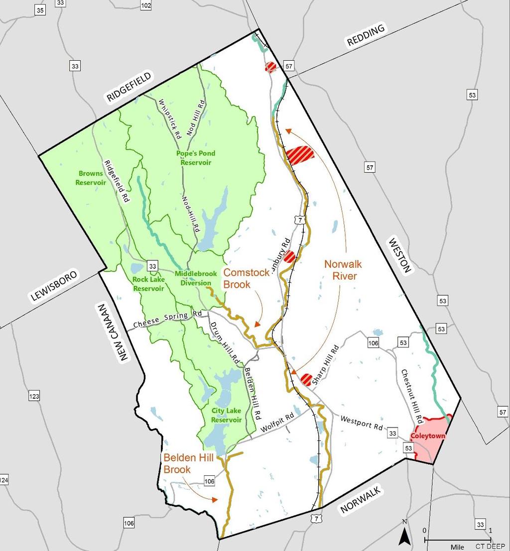
14 Is this in Georgetown? Georgetown Plaza 1039 Danbury Road (former Georgetown Auto Sales) 848 Danbury Road (Yankee Doodle Stoves) 14

15 Are the following uses appropriate for Georgetown? 15
16 Introduction to Tonight s Topic 16


17 Open Space Actions from 2009 POCD Open Space 17
18 Open Space Inventory Open Space Type Number of Properties Open Space Land Area (Acres) Protected Unprotected Total Municipal Land Trust (Owned in Fee Title) Wilton Land Conservation Trust Aspetuck Land Trust Weir Farm Trust New Canaan Land Conservation Trust State and Federal Land State Land Federal Land Former Route 7 ROW Water Company Land , ,160.2 Privately Owned Conersvation Easement/Deed Restriction Public Act 490 (P.A. 490) Designation All Open Space Categories 532 1, , ,083.2 Sources: Town of Wilton, Wilton Land Conservation Trust, CT DEEP 11.3% Protected Open Space 12.0% Unprotected Open Space 23.3% Total Open Space Percent of Total Land Area Percent of Total Land Area Percent of Total Land Area 18


19 Open Space Inventory Larger size map published on the Wilton 2029 website Created using data from Town of Wilton Assessor, CT DEEP, and Wilton Land Conservation Trust Discussion Points: Do residents desire additional town-owned open space? Are bonded conservation easements, as have been used recently, the preferred financial mechanism for municipal open space preservation? 19


20 Water Resources Actions from 2009 POCD 20


21 21


22 Sources: CTDEEP, CTECO Note: Local Aquifer Protection Area data was not available in a digital format 22


23 23


24 Discussion points: Should stormwater regulations be strengthened for new development and/or major redevelopments (such as requiring LID)? What incentives could be established to reduce stormwater runoff on existing properties? How should desire for increased density on Route 7 balance with desire to reduce stormwater runoff? 24


25 Flora and Fauna Actions from 2009 POCD 25


26 26


27 This effort is coordinated by NRWA, Woodcock Nature Center, Wilton Land Conservation Trust, Wilton Conservation Commission, Wilton Garden Club, Ridgefield Garden Club, Caudatowa Garden Club, Ridgefield Conservation Commission, Ridgefield Library, RACE, NRVT, Norwalk Tree Alliance, and more! 27

28 Discussion point: For any required landscaping per Zoning, should use of native plants be required? 28

29 Energy and Sustainability Actions from 2009 POCD 29


30 30


31 Waste Management 31


32 Discussion Points: Should there be a new energy reduction objective for 2029? If so, what should it be? Should there be a waste reduction objective? 32

33 Preservation Action Items from 2009 POCD 33


34 Delineations are approximate and may not be exact Sources: National Park Service, CT OPM, Town of Wilton. 34
 be used for developers who retain historic structures on site or relocate them to designated off site locations? For more information: https://www.nps.")
35 Discussion Point: How can the town incentivize preservation of historic structures on Route 7? Should zoning bonuses (FAR, coverage, parking, setbacks, etc.) be used for developers who retain historic structures on site or relocate them to designated off site locations? For more information: 35


36 Sources: CTDOT, Town of Wilton 36


37 Cultural Resources Action Items from 2009 POCD 37


38 Wilton Library Annual Report 38


39 39
40 Discussion Points: What opportunities exist for greater collaboration between cultural institutions in neighboring communities and the region, and access to offerings for Wilton residents? What opportunities exist to better promote cultural tourism in Town and the region? What role does the Town play in these efforts? 40
41 Open Space Do residents desire additional town-owned open space? Are bonded conservation easements, as have been used recently, the preferred financial mechanism for municipal open space preservation? Water Resources Should stormwater regulations be strengthened for new development and/or major redevelopments (such as requiring LID)? What incentives could be established to reduce stormwater runoff on existing properties? How should desire for increased density on Route 7 balance with desire to reduce stormwater runoff? Flora & Fauna For any required landscaping per Zoning, should use of native plants be required? Sustainability Should there be a new energy reduction objective for 2029? If so, what should it be? Should there be a waste reduction objective? Historic Preservation How can the town incentivize preservation of historic structures on Route 7? Should zoning bonuses (FAR, coverage, parking, setbacks, etc.) be used for developers who retain historic structures on site or relocate them to designated off site locations? Cultural Resources What opportunities exist for greater collaboration between cultural institutions in neighboring communities and the region, and access to offerings for Wilton residents? What opportunities exist to better promote cultural tourism in Town and the region? What role does the Town play in these efforts? 41
42 Discussion of Overarching Themes 42
43 Discussion of Overarching Themes 43
44 Working Group Exercise 44
45 Working Group Exercise 45
46 What s Next? 46
2010 Plan of Conservation and Development
 2010 Plan of Conservation and Development Wilton Planning and Zoning Commission Adopted November 2, 2009 Effective January 1, 2010 WILTON 2010 PLAN OF CONSERVATION & DEVELOPMENT PARTICIPANTS Planning &
OPEN SPACE CHAPTER 7: OVERVIEW. Preserve open space to protect natural resources, enhance character and provide passive recreation opportunities
 CHAPTER 7: OPEN SPACE OVERVIEW Ridgefield has made tremendous progress permanently preserving areas of town as open space. Open space preservation can serve many important purposes, including: protect
FUTURE LAND USE PLAN 7
 FUTURE LAND USE PLAN 7 The recommendations of each of the preceding chapters can be combined to present an overall Future Land Use Plan for Wilton. The Future Land Use Plan, presented on the following
Town of Peru Comprehensive Plan Executive Summary
 Town of Peru Comprehensive Plan Executive Communities that plan grow by choice, not by chance. A plan makes growth thoughtful, understandable, and predictable. A plan shows that a community is managing
7 NEXT STEPS. Next Steps 95
 7 NEXT STEPS To move forward with development of the 135th Street corridor, there are a number of key steps and strategies the City and the community can take to turn the vision for this area into a reality,
Sustainably Repositioning Greyfield Sites. Greyfield Sites Anywhere
 Sustainably Repositioning Greyfield Sites Jim Constantine Looney Ricks Kiss Architects Todd Poole 4ward Planning Greyfield Sites Anywhere Pennsylvania Chapter American Planning Association Conference 2009
RIDGES TO RIVERS OPEN SPACE NETWORI< OF THE MID-COLUMBIA DRAFT ACTION PLAN
 RIDGES TO RIVERS OPEN SPACE NETWORI< OF THE MID-COLUMBIA DRAFT ACTION PLAN Ridges to Rivers Open Space Network of the Mid-Columbia Region Draft Action Plan (8/6/08) The goals of the propose
Sorted citizen input comments in review of Blount County plans July, August, and September 2007
 Sorted citizen input comments in review of Blount County plans July, August, and September 2007 The following presents sorted citizen input comments from three sessions held in July, August and September
NACCED/NACo CONFERENCE JULY 10, 2015
 NACCED/NACo CONFERENCE JULY 10, 2015 Regional Growth Framework 2 Regional Growth Framework Regional Priorities Preferred Growth Concept Tools to Support Local Governments 3 Top Priorities for the CONNECT
VILLAGE & TOWN OF BERGEN: COMPREHENSIVE PLAN
 VILLAGE & TOWN OF BERGEN: COMPREHENSIVE PLAN CPC Public Hearing April 21, 2016 History 1996 Comprehensive Plan Comprehensive Plan Update Committee Consultant (LaBella Associates): December 2014 Residents
RECREATION, OPEN SPACE AND GREENWAYS ELEMENT GOALS, OBJECTIVES, AND POLICIES
 RECREATION, OPEN SPACE AND GREENWAYS ELEMENT GOALS, OBJECTIVES, AND POLICIES GOAL R-1: DEVELOP A RECREATION, OPEN SPACE AND GREENWAYS SYSTEM AS AN INTEGRAL COMPONENT OF AN OVERALL, COUNTY-WIDE ECONOMIC
Minnesota Department of Natural Resource - Natural Resource Guidance Checklist Conserving Natural Resources through Density Bonuses
 Minnesota Department of Natural Resource - Natural Resource Guidance Checklist Conserving Natural Resources through Density Bonuses NRDB Why Use Density Bonuses & This Checklist Local units of government
Historic Preservation Element
 Casa Gardens by Carolyn Pelkey Historic Preservation Element Incorporated in 1928, the City of San Clemente was among the first master planned communities in the U.S. built from open grazing land. Before
Agenda. Presentation (30 minutes) Overview of RIV District Next Steps / Calendar Display Stations. Display Station Discussion
 Overview of RIV District Next Steps / Calendar Display Stations. Display Station Discussion") Agenda Presentation (30 minutes) Overview of RIV District Next Steps / Calendar Display Stations Display Station Discussion RIV District Overview What is in the District? Purpose & Subdistricts Required
Agenda Presentation (30 minutes) Overview of RIV District Next Steps / Calendar Display Stations Display Station Discussion RIV District Overview What is in the District? Purpose & Subdistricts Required
Examples of Asset Based Approaches to Development. Economic and Community Development Suffield, CT
 Examples of Asset Based Approaches to Development Presented by: Patrick McMahon, Director of Economic and Community Development Suffield, CT Neighborhood Commercial Development Wilson, CT Issues Elevated
TABLE OF CONTENTS. Transportation Chapter 1 - Introduction and Purpose of Planning to 1-3. Utilities
 Chapter 1 - Introduction and Purpose of Planning... 1-1 to 1-3 Pennsylvania Municipalities Planning Code (Act 247)...1-1 Previous County Planning Activities...1-1 Objectives of the Plan...1-2 Elements
495/MetroWest Development Compact Plan Citizen Planner Training Collaborative Conference. March 17, 2012
 495/MetroWest Development Compact Plan Citizen Planner Training Collaborative Conference March 17, 2012 Project Process Local and Regional Priority Areas Growth Scenarios Transportation Investment Categories
EXISTING COMPREHENSIVE PLAN
 EXISTING COMPREHENSIVE PLAN Town Center Land Use Element: V. LAND USE POLICIES Town Center Mercer Island's business district vision as described in "Your Mercer Island Citizen-Designed Downtown" was an
Zoning Design Standards. Low Impact Development Code Update Thurston County Planning Commission March 2, 2016
 Zoning Design Standards Low Impact Development Code Update Thurston County Planning Commission March 2, 2016 Background Zoning regulations include limitations on the size and location of structures within
KEIZER STATION PLAN INTRODUCTION
 KEIZER STATION PLAN INTRODUCTION Planning for this area began in 1987 when the Keizer Comprehensive Plan established the Chemawa Activity Center and McNary Activity Center. The first Chemawa Activity Center
WATERFORD Plan of Preservation, Conservation and Development Supplement Part 1 - Policy Element
 WATERFORD 2012 Plan of Preservation, Conservation and Development 2015 Supplement Part 1 - Policy Element Effective June 11, 2015 2015 Plan Update GOAL To respond to the evolving land use needs and continually
Riparian Buffer on the Bushkill Creek. Policies
 Riparian Buffer on the Bushkill Creek Riparian buffers provide numerous benefits to landowners and the community by protecting groundwater recharge areas, providing flood control, providing stormwater
Route 7 Reconstruction and Widening, Wilton. State Project Nos & 124. Wolf Pit Road to just north of Olmstead Hill Road
 Route 7 Reconstruction and Widening, Wilton State Project Nos. 161-118 & 124 Wolf Pit Road to just north of Olmstead Hill Road Tonight s Agenda Introduction Bill Brennan, Wilton First Selectman Construction
Municipal Plan*Assessment
 Municipal Plan*Assessment This tool was developed to assist in reviewing municipal master plans and in determining if these plans are consistent with smart growth principles, neighboring municipal plans,
Provide and maintain sufficient public parks, recreation facilities, and open space to meet the recreational needs of County residents and visitors.
 (ROS) Goal Provide and maintain sufficient public parks, recreation facilities, and open space to meet the recreational needs of County residents and visitors. OBJECTIVE ROS.01 The County shall acquire,
Benzie County Master Plan: Priority Issues & Opportunities
 Benzie County Master Plan: Priority Issues & Opportunities From March 2015 through January 2016, Networks Northwest staff worked with the Benzie County Master Plan Committee to obtain input from the public
I. STAFF POLICY RECOMMENDATIONS. The following RMP policy strategies are proposed by staff in support of a Scenic Resource Protection Program:
 Policy Consideration: Scenic Resource Protection Program Status: For Consideration by the Highlands Council at September 14, 2006 Work session Date: September 12, 2006 I. STAFF POLICY RECOMMENDATIONS The
IMPLEMENTING SOMERSET COUNTY S INVESTMENT FRAMEWORK
 IMPLEMENTING SOMERSET COUNTY S INVESTMENT FRAMEWORK SMART CONSERVATION THROUGH SMART GROWTH NJ LAND CONSERVATION RALLY March 22, 2014 Laurette Kratina, PP, AICP, Supervising Planner Somerset County Planning
Town of Cobourg Heritage Master Plan. Statutory Public Meeting
 Town of Cobourg Heritage Master Plan Statutory Public Meeting April 25 th 2016 Presentation Overview 1. Introduction 2. Project background and schedule overview 3. Review of strategic direction content
Danvers High Street I-1 District Study
 Danvers High Street I-1 District Study Presentation of Final Recommendations Planning Board Presentation June 26 th, 2018 1 Introductions Metropolitan Area Planning Council Sam Cleaves AICP, Principal
EXHIBIT A. Tax Increment Reinvestment Zone No. 1 (Town Center) First Amended Project Plan 1
 First Amended Project Plan 1") EXHIBIT A Tax Increment Reinvestment Zone No. 1 (Town Center) First Amended Project Plan 1 1 As amended by Resolution No. 2008-02-001(TR1R) of the Tax Increment Reinvestment Zone No.1, and approved to
EXHIBIT A Tax Increment Reinvestment Zone No. 1 (Town Center) First Amended Project Plan 1 1 As amended by Resolution No. 2008-02-001(TR1R) of the Tax Increment Reinvestment Zone No.1, and approved to
RECREATION AND OPEN SPACE ELEMENT GOALS, OBJECTIVES, AND POLICIES
 RECREATION AND OPEN SPACE ELEMENT GOALS, OBJECTIVES, AND POLICIES Goal 7 To provide park facilities, recreation programs, and open space resources that are safe, adequate, and accessible to all City residents,
City of Chickasaw Land Use Comprehensive Plan 2030 Chapter5-Draft(2)Public review_
Public review_") Land Use Land Use refers to the activity or development characteristics of a given parcel of land. The Land Use Plan presented in the following pages, represents the City of Chickasaw s official position
Land Use Land Use refers to the activity or development characteristics of a given parcel of land. The Land Use Plan presented in the following pages, represents the City of Chickasaw s official position
Green Infrastructure. by Karen Engel, NYS DEC. NYS Department of Environmental Conservation
 Green Infrastructure by Karen Engel, NYS DEC What is Green Infrastructure? For some it s all about water Green Infrastructure techniques use soils and vegetation to infiltrate, evapotranspirate, and/or
Commercial Node Plan Devine Street/Jackson Blvd. COLUMBIA, SC
 Commercial Node Plan Devine Street/Jackson Blvd. COLUMBIA, SC 9.17.13 AGENDA 1 Introductions 2 Project Update 3 Concepts 4 Recommendations 5 Next Steps Introductions Project Update Process 5-Phase Process
CHAPTER VI Plan Implementation
 Versailles-Midway CHAPTER VI Plan Implementation While prior sections focused on the tools the Commission needs to help it make the dayto-day decisions associated with subdivision, site plan and rezoning
DRAFT Amsterdam/Churchill Community Plan (4/17/08) Adopted By the Gallatin County Commission
 Adopted By the Gallatin County Commission") DRAFT Amsterdam/Churchill Community Plan (4/17/08) Adopted By the Gallatin County Commission Table of Contents Acknowledgements Chapter 1: Introduction A Brief History What s Next Authority Organization
DRAFT Amsterdam/Churchill Community Plan (4/17/08) Adopted By the Gallatin County Commission Table of Contents Acknowledgements Chapter 1: Introduction A Brief History What s Next Authority Organization
Urban Agriculture. Monday, November 14, 2016
 Urban Agriculture Monday, November 14, 2016 1 Martha H. Chumbler Our Guests Carlton Fields, Tallahassee 850.513.3612 mchumbler@carltonfields.com Sorell E. Negro Robinson & Cole LLP, Miami 786.725.4112
New Town Mixed Use District
 New Town Mixed Use District Montgomery County Planning Commission 2009 Annual Conference PA Chapter of the American Planning Association October 6, 2009 What is NTMU? More urban style of development Complementary
City of Toronto Official Plan Indicators
 City of Toronto Official Plan Indicators Attachment 1 2017 Gladki Planning Associates in association with Hemson Consulting & Studio Jaywall City of Toronto Official Plan Indicators 1 Introduction What
EXHIBIT B PROJECT NARRATIVE POULSBO MEADOWS
 EXHIBIT B PROJECT NARRATIVE POULSBO MEADOWS Name of Project: Poulsbo Meadows; A Planned Residential Development (PRD)/Plat Applicants Name: PBH Group LLC/Byron Harris PO Box 1010 Silverdale, WA 98038 Description
MAYFIELD WEST SECONDARY PLAN PHASE 2
 MAYFIELD WEST SECONDARY PLAN PHASE 2 Public Open House #3 February 25, 2010 Draft Preferred Land Use Scenario TOWN OF CALEDON PLANNING & DEVELOPMENT DEPARTMENT Open House Agenda TOWN OF CALEDON 1. Welcome
Transportation. Strategies for Action
 Transportation A major priority for the Overlake Neighborhood is to develop a multimodal transportation system. To achieve this system, a balance has to be found among travel, circulation and access needs;
Branchville. Transit Oriented Development Plan Charrette and Survey Outcomes 10/30/15
 Branchville Transit Oriented Development Plan Charrette and Survey Outcomes 10/30/15 About the Branchville TOD Plan The Town of Ridgefield is currently working with the Western Connecticut Council of Governments
The Next Great Growth. The Next Great Growth Region of Florida. Infrastructure and Other Improvements. A Presentation Delineating the Major
 The Next Great Growth The Next Great Growth Region of Florida A Presentation Delineating the Major Infrastructure and Other Improvements in Central Northwest Florida Why Here? Why Now? Why Here? Why Now?!
OPEN SPACE FORUM SEPTEMBER 28, 2016 THE ARTS CENTER
 OPEN SPACE FORUM SEPTEMBER 28, 2016 THE ARTS CENTER AGENDA: 1. Introductions 2. History of Open Space Committee 3. Saratoga Springs Open Space Purchases 4. Committee Actions and Path Forward 5. Comments
It Takes A Village.. Preserving Rural Character In Standish
 It Takes A Village.. Preserving Rural Character In Standish A Public Workshop Hosted by Conservation and Open Space Plan Committee & Standish Corner Village Implementation Committee June 12, 2008 Desired
Envision Concord Public Event Part 3. October 21, :30 AM 12:00 PM Concord-Carlisle High School Cafeteria
 Envision Concord Public Event October 21, 2017 9:30 AM 12:00 PM Concord-Carlisle High School Cafeteria Survey Responses + Emerging Priority Areas Summary from Spring Kick-Off Event Envision Concord Survey
LRPC VISION GOALS-OBJECTIVES-STRATEGIES
 ENVIRONMENT: Wooded surroundings, meandering creeks and natural beauty allow residents to enjoy the benefits of living in a low-density village setting with quick and easy access to the offerings of the
Goal 1 To establish and follow land use patterns for the long-range development of the campus.
 ELEMENT 4 FUTURE LAND USE Goal 1 To establish and follow land use patterns for the long-range development of the campus. Objective 1A Correct existing incompatible campus land uses. Policy 1A-1 Reduce
North Central Conservation District
 North Central Conservation District Annual Report Fiscal Year 2015-2016 2016 www.conservect.org/northcentral North Central Conservation District Introduction This Annual Report summarizes work performed
INTEGRATING NATURAL RESOURCES INTO A DEVELOPMENT, PUBLIC AND PRIVATE ROLES
 INTEGRATING NATURAL RESOURCES INTO A DEVELOPMENT, PUBLIC AND PRIVATE ROLES Why? Integrating natural resources into a development can increase its market value, enhance the quality of life for those who
Village District Information Session MONDAY JUNE 18, :30PM CITY COUNCIL MEETING
 Village District Information Session MONDAY JUNE 18, 2018 7:30PM CITY COUNCIL MEETING What is a village district? 2 Village Districts encourage the conversion, conservation and preservation of existing
ATTACHMENT A. Town of Lebanon Village Center Study Proposal Cover Sheet (to be included with Proposal) Contract shall not exceed $48,500.
 Contract shall not exceed $48,500.") ATTACHMENT A Town of Lebanon Village Center Study Proposal Cover Sheet (to be included with Proposal) Contract shall not exceed $48,500. Price to complete the survey as described $ Price to be submitted
ATTACHMENT A Town of Lebanon Village Center Study Proposal Cover Sheet (to be included with Proposal) Contract shall not exceed $48,500. Price to complete the survey as described $ Price to be submitted
TOWN OF BETHLEHEM OPEN SPACE CONSERVATION PLAN PUBLIC MEETING: OCTOBER 12, 2017
 TOWN OF BETHLEHEM OPEN SPACE CONSERVATION PLAN PUBLIC MEETING: OCTOBER 12, 2017 Welcome and Agenda 6:00 6:45: Open House, Part One 6:45 7:15: Presentation and Questions 7:15 8:00: Open House, Part Two
SPRINGHILL LAKE TRANSIT VILLAGE
 Greenbelt Metro Area Sector Plan - Subarea Design Policies and Guidelines - Springhill Lake Transit Village 113 SPRINGHILL LAKE TRANSIT VILLAGE Residential Neighborhood and Village Center CONCEPT Springhill
2018 Northampton Township Comprehensive Plan
 2018 BUCKS COUNTY, PENNSYLVANIA What is a? A comprehensive plan is a municipality s main policy document that details the collective vision for the future, the historic, environmental, and cultural facilities
10 Implementation. Implementation. Responsibility for Implementation. Blueprint for Bloomsburg. Town of Bloomsburg Comprehensive Plan 10-1
 Implementation 10 Implementation This chapter overviews how to use the comprehensive plan as a land use and programming tool for the Town of Bloomsburg and recommends annual review of the plan by the Town
Laberge Group. Town of Coeymans. Draft Comprehensive Plan. Overview of Planning Process
 Draft : Presentation of Goals & Strategies Laberge Group Benjamin H. Syden, A.I.C.P., E.D.P Director in Charge Nicole Allen, A.I.C.P. Senior Planner Anjali Malhotra Planner Presentation Outline Introductions
The ACTION PLAN OBJECTIVES, POLICIES, ACTIONS
 The ACTION PLAN OBJECTIVES, POLICIES, ACTIONS Responsible actors Key actors Funds needed and funding sources available OBJECTIVE 1 Strengthening the governance and the social capital through the development
Downtown River District
 City & Downtown Development Authority Partnership Infrastructure Analysis & Design Project Transportation & Utilities Fix Current Deficiencies Set the Stage for Future Infill & Redevelopment Who s Involved:
SECTION ONE: INTRODUCTION. introduction
 introduction 1 INTRODUCTION Since it was first established in 1843 as a trading post for the Hudson s Bay Company, Victoria has evolved into a Provincial capital city that is recognized across Canada and
Dwelling Units Max 12 dwelling units per acre/min 8 dwelling units per acre. Development Mix 80% non residential/20% residential
 13. OSTEEN LOCAL PLAN Background: The Osteen Local Plan area is located in southwest Volusia County along the SR 415 corridor between Lemon Bluff Road and Acorn Lake Road and includes 3,990 acres. The
Mark-up of the effect of the proposed Bronte Village Growth Area OPA No.18 on the text of section 24, Bronte Village, of the Livable Oakville Plan
 Mark-up of the effect of the proposed Bronte Village Growth Area OPA No.18 on the text of section 24, Bronte Village, of the Livable Oakville Plan Notes: This document is provided for information purposes
Energize Connecticut Upstream Residential HVAC Program
 Energize Connecticut Upstream Residential HVAC Program Presented at the 2015 ACEEE National Conference on Energy Efficiency as a Resource September 22, 2015 Jennifer Parsons - UI, SCG, and CNG Presentation
Open Space and Farmland Preservation
 Vibrant. Green. Connected. Competitive. Open Space and Farmland Preservation Statement of Purpose The purpose of this section of the Plan is to encourage and support the preservation of open space areas
Implementation Vision
 Introduction The implementation chapter is the how to portion of the plan. It describes the actions necessary to realize the visions presented in this document through the goals, objectives, and policies
MONTCO 2040: A SHARED VISION The New Comprehensive Plan for Montgomery County. Dra Themes and Goals March, 2014
 MONTCO 2040: A SHARED VISION The New Comprehensive Plan for Montgomery County Dra Themes and Goals March, 2014 INTRODUCTION 2 WHAT IS A COMPREHENSIVE PLAN? A comprehensive plan is a long-range plan required
Planning for and Managing Open Space and Natural Areas
 Planning for and Managing Open Space and Natural Areas Increasingly, development proposals in Delaware include large amounts of open space and natural areas. While open space is important as a community
Welcome. Walk Around. Talk to Us. Write Down Your Comments
 Welcome This is an information meeting introducing the applications for proposed redevelopment of the Yorkdale Shopping Centre site at 3401 Dufferin Street and 1 Yorkdale Road over the next 20+ years,
The transportation and land use connection
 The transportation and land use connection A sustainable trend? 180% 160% 140% 120% 100% 80% 60% 40% 20% 0% Annual vehicle miles traveled US Population Road mileage We re driving more. Infrastructure can
International Green Roof City Network Case Study Seattle, Washington USA
 International Green Roof City Network Case Study Seattle, Washington USA 1) City Data Location Seattle, Washington is located in the Pacific Northwest of the United States. The city is situated between
Stillwater Comprehensive Plan. Discussion Draft. Informational Open House. February 9, 2006
 Stillwater Comprehensive Plan Discussion Draft Informational Open House February 9, 2006 Purpose Goal for Tonight s Meeting How We Got Here Present Recommendations How you can provide Comment Next Steps
Introducing the Main Street Strategic Toolbox
 Ulster County Main Streets: A Regional Approach Ulster County Planning Department, 244 Fair Street, Kingston NY 12401 Why do we take a regional approach to Main Streets? There are many different approaches
East Central Area Plan
 East Central Area Plan Steering Committee Meeting March 8 th, 2018 CHUN Tears McFarlane House Vision Statement Development Opportunities Analysis Vision Elements 1. Equitable, Affordable and Inclusive
HELPING SMALL TOWNS AND RURAL AREAS THRIVE
 EPA Office of Sustainable Communities HELPING SMALL TOWNS AND RURAL AREAS THRIVE Village of Vinton, Texas May 30, 2013 Katharine Ange, AICP Renaissance Planning Group Overview of Workshop Discussion of
Chapter 1 - General Design Guidelines CHAPTER 1 GENERAL DESIGN GUIDELINES
 CHAPTER 1 GENERAL DESIGN GUIDELINES 1.0 INTRODUCTION This Publication has been developed to provide current, uniform procedures and guidelines for the application and design of safe, convenient, efficient
2. Analysis. DRAFT Gerald Richards & Pleasantview Park Master Plan
 DRAFT Gerald Richards & Pleasantview Park Master Plan 19 Historic Features According to the National Register of Historic Places and the National Historic Landmarks Program, there is nothing of national
Downtown Whitby Action Plan
 Downtown Whitby Action Plan Final Report October 2016 Table of Contents Introduction 1 Public Consultation 2 Walkability 3 Downtown Whitby Walkability Map 4 Vision 5 Goal & Objectives 6 Objective 1 7 Objective
CONCLUSION AND IMPLEMENTATION
 Lisbon s Vision CONCLUSION AND IMPLEMENTATION 7 Lisbon residents clearly appreciate the character, amenities, and opportunities that define our community. This Plan of Conservation and Development identifies
COMMUNITY DESIGN. GOAL: Create livable and attractive communities. Intent
 COMMUNITY DESIGN Intent An attractive, well-designed County will attract quality development, instill civic pride, improve the visual character of the community, and create a strong, positive image for
ITA and Vicinity Master Plan Update
 1 ITA and Vicinity Master Plan Update PHASE 3 SEPTEMBER 27, 2017 Three Phase Process 2 Phase 1 - Understanding October 13th Public Meeting Phase 2A - Exploring Ideas November 17th Public Meeting Phase
Secrest Short Cut and Monroe Expressway Small Area Plan AUGUST 29, 2018
 Secrest Short Cut and Monroe Expressway Small Area Plan AUGUST 29, 2018 Background and Process Monroe Expressway will be open by the end of 2018 Union County and Indian Trail identified a need to revisit
Windsor, Connecticut Plan of Conservation & Development DRAFT PLAN SUMMARY
 Windsor, Connecticut 2015 Plan of Conservation & Development DRAFT PLAN SUMMARY Plan Overview What is a Plan? Visionary Advisory Implementable Maintainable What it is not! Regulatory Binding Static Passive
Silverdale Regional Center
 Silverdale Regional Center Vision for Silverdale Regional Center The Silverdale Regional Center Plan (Plan) will guide the evolution of the Silverdale Regional Center from a collection of strip malls and
City of Cambridge: Study of Green Building Standards
 City of Cambridge: Study of Green Building Standards Prepared by the Sustainable Planning Associates December 4, 2015 Richard Buchan Alexandra Graham Jon Ponder Nuo Jin (Steven) Qi The Business Case 2
CHAPTER 5: GUIDING PRINCIPLES
 CHAPTER 5: GUIDING PRINCIPLES The following 10 principles were developed based on public consultation, planning policy and the background analysis conducted during Phase 1. The Guiding Principles significantly
Public Open House #1
 Public Open House #1 TONIGHT S AGENDA Welcome Project Overview The Big Picture The Station Area The Analysis Thoughts about Future Change Breakout Group Discussions Summation / Next Steps Project Overview
SUSSEX COUNTY COMPREHENSIVE PLAN COUNTY PLANNING AND ZONING COMMISSION WORKSHOP
 SUSSEX COUNTY COMPREHENSIVE PLAN COUNTY PLANNING AND ZONING COMMISSION WORKSHOP August 21, 2017 TODAY S WORKSHOP Public Comment Utilities Update Economic Development Update Future Land Use Discussion Public
FARMLAND PRESERVATION AND PUBLIC POLICY ISSUES
 FARMLAND PRESERVATION AND PUBLIC POLICY ISSUES Lancaster County, home to the richest, most productive agricultural soils in the country, faces a tough battle in efforts to preserve our home, our harvest,
1120 Haist Street - Pelham Arena Community Co-Design Recommendation Report Haist Street - Pelham Arena Community Co-Design Recommendation Report
 1120 Haist Street - Pelham Arena Community Co-Design Executive Summary: In May, 2017 the Town retained the services of The Planning Partnership to undertake a community design charrette process to determine
Appendix I. Access Management & Land Use Zoning Strategies Memo
 Appendix I ` Access Management & Land Use Zoning Strategies Memo Route 96 Access Management and Land Use/Zoning Strategies The Town of Victor has access management guidelines in Section 5.0 of the 2014
CHAPTER 4 COMMUNITY DEVELOPMENT AND DESIGN
 CHAPTER 4 COMMUNITY DEVELOPMENT AND DESIGN The Community Development and Design Chapter is extremely important because it, together with the Transportation and Circulation Chapter, provides the foundation
Purpose of Zoning Regulations. B-L Zoning Amendment. B-L Zone Permitted Uses. B-L Zone Definitions. History of B-L Zone. Map of B-L Zones in City
 Purpose of Zoning Regulations B-L Zoning Amendment May 20, 2003 City of Cumberland http://www.adventuregovernment.com Zoning districts are established to provide appropriate locations for different types
Pittsfield Action Plan (West Branch of the Housatonic River)
") An initiative of the Massachusetts Executive Office of Energy and Environmental Affairs in partnership with the City of Pittsfield Pittsfield Action Plan (West Branch of the Housatonic River) The spring
An initiative of the Massachusetts Executive Office of Energy and Environmental Affairs in partnership with the City of Pittsfield Pittsfield Action Plan (West Branch of the Housatonic River) The spring
Natural Resource Adaptation Action Area Addressing Sea Level Rise in Estuarine Ecosystems TO: TOWN OF YANKEETOWN MAY
 Natural Resource Adaptation Action Area Addressing Sea Level Rise in Estuarine Ecosystems TO: TOWN OF YANKEETOWN MAY 6 2013 University of Florida Conservation Clinic Vivek Babbar, Student Associate, J.D.
Chapter 6. Overall Vision RECOMMENDATIONS. More Trail and Trail. Connections. Equal Access to Park. Facilities and Programs. Water Access.
 Overall Vision More Trail and Trail Connections Equal Access to Park Facilities and Programs Water Access Environment Variety Chapter 6 RECOMMENDATIONS Chapter 6 The following recommendations for park,
Floyds Fork Area Study Project Overview, Suitability Analysis, & Form Districts July 29, title
 Floyds Fork Area Study Project Overview, Suitability Analysis, & Form Districts July 29, 2008 Agenda Floyds Fork Area Study Project overview and purpose Process and schedule Ongoing initiatives Floyds
HOUSING ELEMENT GOALS, OBJECTIVES, AND POLICIES
 HOUSING ELEMENT GOALS, OBJECTIVES, AND POLICIES Goal 6 Maintain and enhance the supply of decent, safe, energy efficient and affordable housing and maximize viable options and opportunities for present
Today Land & People. Northeast Nampa Gateway District. Employment. Land Use Characteristics. Demographics. Current Zoning
 Today Land & People Employment Major employers include Saint Alphonsus, the College of Western Idaho, the Auto Mall, Sorrento Lactalis and Walmart. 3,004 jobs in 2010 (COMPASS-CIM 2040 TAZ data) 4,345