ECOLOGICAL CHARACTERIZATION STUDY 5305 ZIEGLER ROAD
|
|
|
- Arnold Ward
- 5 years ago
- Views:
Transcription
1 5305 ZIEGLER ROAD Prepared for: Architecture West, LLC 4710 South College Avenue Fort Collins, Colorado Attention: Mr. Stephen Steinbicker CTL T Project No. FC May 31, Linden Street, #140 Fort Collins, Colorado Telephone:
2 TABLE OF CONTENTS 1.0 INTRODUCTION SITE DESCRIPTION Wildlife Wetlands Prominent views Significant native trees or other on-site vegetation Bank, shoreline, high water mark Sensitive and specially valued species Special habitat features Wildlife migration corridors General ecological functions Timing of development in relation to ecological character Measures needed to mitigate adverse impacts on natural habitats and features CONCLUSIONS AND RECOMMENDATIONS...5 REFERENCES FIGURE ZIEGLER ROAD GENERAL LAND COVER TYPES FIGURE ZIEGLER ROAD DRAFT DEVELOPMENT PLAN APPENDIX A SITE PHOTOGRAPHS
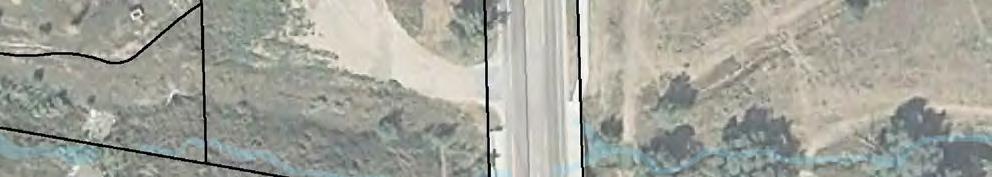
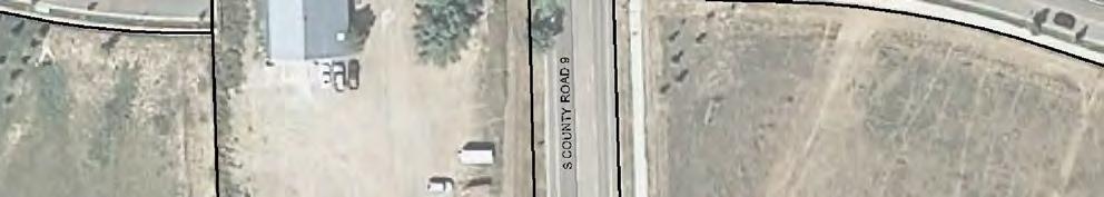
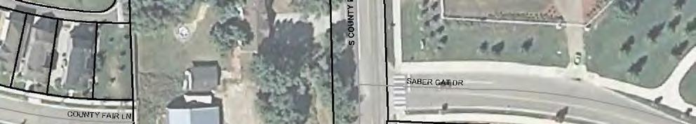
3 1.0 INTRODUCTION This report documents the evaluation of habitat conditions within the proposed 5305 Ziegler Road Multifamily/Mixed Use Development in Fort Collins, Colorado. The report was prepared in accordance with Section (D)(1) of the Land Use Code of the City of Fort Collins regarding the preparation of an Ecological Characterization Study (ECS) Report. An ECS is required as the site is within 500 feet of McClelland s Creek, a known natural habitat. McClelland s Creek is a tributary to the Fossil Creek Reservoir. 2.0 SITE DESCRIPTION The proposed 5305 Ziegler Road Multifamily/Mixed Use Development encompasses approximately 4 acres and is located on the west side of Ziegler Road approximately ¾ mile south of Harmony Road (Figure 1). The site extends about 700 feet north to south and 230 feet east to west. The site is bounded to the north by development, to the east by Ziegler Road, to the south by McClelland s Creek, and to the west by residential development and detention ponds. The legal description of the property is a portion of the NE ¼ of the SE ¼ of Section 5, Township 6N, Range 68W, 6 th Principal Meridian. The site was visited on November 17, December 14, and December 16, 2011 by Ms. Georgia Doyle, a CTL biologist, to perform an ecological assessment and to map the edge of the McClelland s Creek riparian area. During the site visits, most of the vegetation (trees, shrubs, forbs, and grasses) was dormant but dominant plant species were generally identifiable. The current land cover types on the site include the McClelland s Creek riparian area, a small area of upland plains shrubland adjacent to McClelland s Creek, a disturbed area with a gravel parking area and associated outbuildings, and a residence and outbuildings surrounded by lawn grasses/weeds and established trees (Figure 1). Photographs of the site are provided in Appendix A. General characteristics of the identified land cover types are summarized as follows: McClelland s Creek riparian area The creek and riparian area cover an area of about 0.25 acre in the southernmost portion of the property. The creek is densely vegetated with cattail (Typha latifolia) with some areas of the open water supporting the non-native and widespread watercress (Nasturtium officinale). Other plants growing within the riparian/wetland area include bulrush (Scirpus microcarpus), sedges (including Carex nebrascensis and C. praegracilis), and threesquare bulrush (Scirpus pungens). Along the bank there are a few small diameter (<6 diameter at breast height) cottonwood (Populus sp.) that were likely planted as part of a revegetation effort. Upland plains shrubland adjacent to McClelland s Creek The riparian area (dominated by cattail and sedges) abruptly shifts to upland grass species with change in elevation. This upland vegetation covers about 0.2 acre. The bank supports a few shrubs (likely planted as part of revegetation effort) and mixed grasses and forbs. The shrubs include a red-osier dogwood (Cornus sericea) and a few golden currant (Ribes aureum) on the 1
4 lower bank and a few rabbitbrush (Chrysothamnus nauseosus) and yucca (Yucca glauca) on the upper bank. Grasses noted include the native species indiangrass (Sorghastrum nutans), western wheatgrass (Pascopyrum smithii), sideoats grama (Schizachyrium scoparium), and blue grama (Bouteloua gracilis), and the non-native species smooth brome (Bromus inermis), cheatgrass (Bromus tectorum), and crested wheatgrass (Agropyron spicatum). Non-native kochia (Bassia scoparia) is also present. Disturbed area The disturbed area covers an area of about 2 acres and includes an unvegetated gravel parking area and a few buildings. The area is fenced. Kochia and other non-native species occur around the edges of the compacted unvegetated parking area. One cottonwood occurs adjacent to Ziegler Road at the entrance to the parking area. Residence and surroundings The residence, outbuildings, and associated yard cover approximately 1 acre. Trees/shrubs within the area include a row of non-native Siberian elm along the western boundary, a row of nonnative Russian olive along the northern boundary, and a hedge of lilac along the eastern boundary (Ziegler Road). The trees on the property are discussed further in Section 3.4. The yard vegetation includes bare ground and lawn grasses with common weeds including kochia, bindweed, mallow, and dandelion. 3.0 The elements of the Ecological Characterization Study are summarized in this section in the order listed in Section (D)(1) of the Land Use Code. 3.1 Wildlife Wildlife observed during field visits to McClelland s Creek included a pair of mallards in the creek, unidentified songbirds in the rabbitbrush adjacent to the creek, and an American kestrel and red-tailed hawk in the vicinity. Wildlife sign included coyote droppings and rabbit droppings adjacent to the creek. A variety of songbirds likely use the area yearround. Mammal species likely to use the area include mule deer, coyote, raccoon, fox, striped skunk, mice, and non-native fox squirrels. In itself, the site provides relatively low wildlife value due its small size, previous disturbance, and limited food and cover provided by the sparse trees and shrubs. The primary wildlife value of the site is likely in providing connectivity with the McClelland s Creek corridor. Wildlife observed associated with the established trees of the residence area included a pair of great horned owls in the row of Siberian elm along the western property boundary. Great horned owls generally nest in abandoned tree nests built by raptors or corvids (e.g., crows and ravens) (Ehrlich et al. 1988), which build nests out of sticks. A small nest built of sticks was present in one of the Siberian elm trees on the site. Great horned owls can nest as early as late January with peak egg laying occurring mid March (Kingery 1998). The stick nest should be checked in February/March for signs of use by the owls. Also 2
5 observed foraging within the Siberian elm trees and underbrush were dark-eyed juncos and black-capped chickadees, typical winter songbirds for Fort Collins. A variety of songbirds likely use the area year round. Wildlife sign observed included rabbit droppings. 3.2 Wetlands The general boundary of the wetland or riparian area is shown on Figure 2. The boundary represents the contact of wetland plants (sedges) and upland grass species. The boundary was flagged on December 14, 2012 and subsequently surveyed. The boundary corresponds with the elevation contours. McClelland s Creek is considered a water of the U.S. and is regulated by the Army Corps of Engineers. Wetlands are present along McClelland s Creek. However, no wetlands or waters of the U.S. will be impacted by the proposed development as the development, including temporary impacts associated with grading and landscaping, intentionally provides a buffer for the creek and wetlands. Further, the structures are set back from the wetland features due to floodplain buffers. As required by the City of Fort Collins Land Use Code, an undeveloped buffer will occur between McClelland s Creek and the planned structures (Figure 2). No proposed temporary or permanent impact to regulated wetlands or waters of the U.S. are proposed in this project. 3.3 Prominent views The prominent views from this site include the Rocky Mountains to the west, the open space associated with McClelland s Creek, and the open space and Fossil Ridge High School to the east. The proposed structures should not impact the view of the Rocky Mountains from Ziegler Road or McClelland s Creek. 3.4 Significant native trees or other on-site vegetation Significant trees are defined in the Land Use Code as trees with a diameter at breast height (DBH) of over six inches. Certain species are considered nuisance species and are not designated as significant regardless of DBH. Mr. Tim Buchanan, City Forester documented the significant trees on the site on January 11, Approximately 15 trees on the site were designated as significant. The significant trees include one cottonwood (female) on Ziegler Road adjacent to the current curbcut leading to the gravel parking area and about 100 feet north McClelland s Creek. The current development plans call for protecting this tree. Significant trees associated with the residence in the northern part of the site included Colorado blue spruce, green ash, cottonwood, hackberry, Austrian pine, and pinyon pine. Also present on the site are Siberian elm and Russian olive, trees considered nuisance species and not considered significant. The significant trees will either be protected or mitigated. Mitigation for all trees proposed for removal will be transplanting or replacing in accordance with Land Use Code Standards in consultation with the City Forester. 3.5 Bank, shoreline, high water mark The bank along McClelland s Creek appears to control flow. The bank height is approximately 5 feet above the level of McClelland s Creek. In the current development plan, the creek bank is not affected. The proposed development plan calls for maintaining the existing stream bank. A waiver of the requirement for onsite detention will be requested for this development due to its proximity to McClelland s Creek; however, water 3
6 quality measures will be provided at various locations within the development and may include the buffer area between McClelland s Creek and the proposed structures. 3.6 Sensitive and specially valued species There are no known occurrences or habitat for sensitive and specially valued species on the site. Species of concern in Larimer County include the Preble s meadow jumping mouse (Zapus hudsonius preblei), Ute lady s tresses orchid (Spiranthes diluvialis), and Colorado butterfly plant (Gaura neomexicana ssp. coloradensis), all of which are associated with riparian/wetland areas. According to the U.S. Fish and Wildlife Service (Misztal 2011 pers. comm.), all trapping for the Preble s meadow jumping mouse in Fort Collins has been negative. Additionally, the habitat on McClelland s Creek is poor quality for the mouse. Based on the poor habitat conditions and the negative trapping data, it is our professional opinion that Preble s does not occur on the site and development of this project will not affect Preble s adversely. Similarly, it is our opinion that the Ute lady s tresses and Colorado butterfly plant do not occur on the site. The closest known occurrences of these plants are near the northwest boundary of Fort Collins (orchid) and on Soapstone Prairie Natural Area near the Wyoming border (butterfly plant). Additionally, these plants would occur in an undisturbed setting and habitat restoration has occurred on McClelland s Creek. Other plant and animal species included in the Colorado Natural Heritage Program tracking list are not known to occur in the vicinity. 3.7 Special habitat features The site does not contain any special habitat features. 3.8 Wildlife migration corridors McClelland s Creek likely serves as a wildlife migration corridor. The current development plans do not call for development along McClelland s Creek and allow a buffer; therefore, the proposed development should not affect the functioning of McClelland s Creek as a wildlife corridor. 3.9 General ecological functions General ecological functions of McClelland s Creek and the associated riparian area include flood control, groundwater recharge, wildlife habitat, water quality improvement, and open space. The general ecological functions of the site are expected to be improved in the process of development of the site. The fence around the disturbed area will be removed and the area between McClelland s Creek and the structures will be revegetated with native species. The buffer area between McClelland s Creek and the structures will provide topographic and vegetative structure to an area that is currently a gravel parking area. The design and revegetation of the buffer area will take into account the guidance provided in the City of Fort Collins Landscape Design Standards and Guidelines for Stormwater and Detention Facilities dated November 5, Timing of development in relation to ecological character The primary concern for the timing of development is protection of nesting birds. Under the Migratory Bird Treaty Act of 1916, it is unlawful to pursue, hunt, take, capture, kill, or sell 4
7 birds. This includes the taking of feathers and nests of migratory birds. If tree removal or construction commences during the bird breeding season, a survey for active nests should occur and nests should be avoided until activity ends. In addition, CDOW provides recommended guidelines for seasonal buffers for nesting raptors. The breeding season for most migratory birds is between March and August. As discussed in Section 3.1, the nesting season for great horned owls is earlier in the year. The timing of tree removal in the northern portion of the property needs to be timed to avoid disturbing nesting species. Because the McClelland s Creek area is not proposed for development or disturbance, the timing of development is not a concern in this area Measures needed to mitigate adverse impacts on natural habitats and features There are no known impacts to natural habitats or features on the site. The permanent impact will occur on previously disturbed areas primarily consisting of a gravel parking area, buildings, and non-native plantings. Measures to improve the site include creation of a detention basin or possibly, low impact development bioswales, that will provide a buffer between McClelland s Creek and the proposed structures. The buffer area will be vegetated with native plants. The proposed construction period is not yet known. If construction or tree removal is proposed to begin during the potential bird nesting periods, a nest search is recommended within two weeks prior to the start of construction or tree removal to avoid Migratory Bird Treaty Act infractions. Construction Best Management Practices would be used to mitigate any sedimentation of McClelland s Creek. 4.0 CONCLUSIONS AND RECOMMENDATIONS It is CTL s professional opinion that no significant ecological resources will be adversely impacted on this site. The primary concern in our opinion is timing of the construction and removal of trees to avoid disturbing nesting birds. The development plan is consistent with the intent of the Land Use Code. Furthermore, the site design offers features to enhance the ecological functions and values of the site. We ask that you review this ECS with the draft development plan submittal shown in Figure 2 to ensure that the performance standards for this project are achieved. If you have any questions about this ECS or would like to discuss this project further, please feel free to contact us. 5
8 Respectfully submittted, CTL THOMPSON, INC. Reviewed by: Georgia A. Doyle Environmental Scientist/Biologist Melissa Chalona, P.E. Environmental Department Manager (2 copies sent) REFERENCES Ehrlich, P.R., D.S. Dubkin, and D. Wheye The Birder s Handbook, A field guide to the natural history of North American birds. Simon and Schuster, Inc. New York. 785 pp. Kingery, H. (ed.). Colorado Breeding Bird Atlas Colorado Bird Atlas Partnership. 636 pp. Misztal, A communication from Adam Misztal, U.S. Fish and Wildlife Service, Lakewood, Colorado to Georgia Doyle, CTL Thompson, Inc. November 7. 6


9


10
11 APPENDIX A SITE PHOTOGRAPHS


12 McClelland s Creek, looking northeast McClelland s Creek, looking west McClelland s Creek from Ziegler Road, looking northeast Detention pond on adjacent property to the east Site Photographs 5305 Ziegler Road Fort Collins, Colorado November-December 2011 Page 1 of 2 CTL T Project No. FC


13 Unpaved parking and outbuildings north of McClelland s Creek Cottonwood on Ziegler Road 100 feet north of McClelland s Creek Site Photographs 5305 Ziegler Road Fort Collins, Colorado November-December 2011 Page 2 of 2 CTL T Project No. FC
ADDENDUM TO BIOLOGICAL SCOPING SURVEY REPORT, BOTANICAL SURVEY AND WETLAND DELINEATION
 ADDENDUM TO BIOLOGICAL SCOPING SURVEY REPORT, BOTANICAL SURVEY AND WETLAND DELINEATION FOR AVALON INN (APN 069-241-27 & -04) 1201 & 1211 NORTH MAIN STREET FORT BRAGG, CA MENDOCINO COUNTY prepared for:
Broomfield Open Space, Parks, Recreation and Trails Master Plan Appendix E
 Broomfield Open Space, Parks, Recreation and Trails Master Plan Management and Maintenance Guidelines for Open Space P R E P A R E D F O R : City and County of Broomfield June 2004 P R E P A R E D B Y
WETLAND SOD u Bare Root Wetland Plants u Deep Rooted Willows u Coir Logs u Native Trees & Shrubs u Habitat Islands u Custom Growing
 WETLAND SOD u Bare Root Wetland Plants u Deep Rooted Willows u Coir Logs u Native Trees & Shrubs u Habitat Islands u Custom Growing 2009 PROJECT HIGHLIGHTS The following 10 projects highlight the interesting
March 30, Mr. David Singer Environmental Planner CDOT Region S. Holly Street, Room 200 Denver, Colorado 80222
 March 30, 2011 Mr. David Singer Environmental Planner CDOT Region 6 2000 S. Holly Street, Room 200 Denver, Colorado 80222 Subject: Biological Resources Summary for the Proposed Colorado Center Bicycle/Pedestrian
Limpia Creek Duck Pond. 25 acres, Jeff Davis County
 Limpia Creek Duck Pond 25 acres, Jeff Davis County Limpia Creek Duck Pond Hwy 17 N, 25 acres Jeff Davis County, Texas James Tammy King, Agent Broker Office King Land 432 & 426.2024 Water, LLC 432 426.2024
Chagrin River Watershed Partners, Inc. Local Regulations. Amy H. Brennan (440)
") Chagrin River Watershed Partners, Inc. Local Regulations Amy H. Brennan (440) 975-3870 www.crwp.org abrennan@crwp.org July 9, 2013 Applicable Zoning and Building Codes Erosion and Sediment Control Grading
Chagrin River Watershed Partners, Inc. Local Regulations Amy H. Brennan (440) 975-3870 www.crwp.org abrennan@crwp.org July 9, 2013 Applicable Zoning and Building Codes Erosion and Sediment Control Grading
City of Loveland Natural Areas Sites
 City of Loveland Natural Areas Sites 2007 -insert full page photo- July 2008 In the Nature of Things: City of Loveland Natural Areas Sites An update to the citizens and officials of Loveland, Colorado
PICTURE CANYON Planning Riparian-Wetland Refugia in an Urban Setting
 PICTURE CANYON Planning Riparian-Wetland Refugia in an Urban Setting Rio De Flag Existing Conditions. Ephemeral stream; Limited riparian plants, habitats.. & Opportunities Water (effluent) available Restore
Zoning Ordinance Article 3
 Article 3 Natural Resources Protection Section 301 Natural Resources Protection 301.1. Purpose - The following natural resources protection standards are established to protect the public health, safety
SITE INTRODUCTIONS AND OVERVIEW
 SITE INTRODUCTIONS AND OVERVIEW The City s formal Open Space Program was established in 1990 to implement long-standing policies that called for the protection of the farmlands and wild areas that surround
Open Space, Natural Areas, Parks, and Recreation
 Open Space, Natural Areas, Parks, and Recreation WHAT ARE THE CITY S CURRENT VALUES? This section addresses open spaces, natural areas, parks and recreation, and stormwater multi-use projects under separate
Decision Notice. Proposed Action
 Decision Notice Paving Weld County Road 105 USDA Forest Service Arapaho and Roosevelt National Forest and Pawnee National Grassland Pawnee National Grassland Ranger District Weld County, Colorado November
City of Sun Prairie Wetland Buffer Reduction Request
 City of Sun Prairie Wetland Buffer Reduction Request Westside Development Area January 9, 2017 Prepared by: City of Sun Prairie 300 E. Main Street Sun Prairie, WI 53590 BACKGROUND The City of Sun Prairie
Burrowing Owl Habitat Project at the Albany Plateau. (a component project of the Gilman Street Playing Fields Project City of Berkeley) March 10, 2006
 March 10, 2006") Burrowing Owl Habitat Project at the Albany Plateau (a component project of the Gilman Street Playing Fields Project City of Berkeley) March 10, 2006 Submitted by The City of Berkeley Project history During
Burrowing Owl Habitat Project at the Albany Plateau (a component project of the Gilman Street Playing Fields Project City of Berkeley) March 10, 2006 Submitted by The City of Berkeley Project history During
Stormwater Standards. Clackamas County Service District No. 1. Planting Guide for Buffers
 Stormwater Standards Clackamas County Service District No. 1 APPENDIX B Planting Guide for Buffers Table of Contents Appendix B - Planting Guide for Buffers... Page B.1 General... 1 B.1.1 Introduction...
ENBRIDGE GAS DISTRIBUTION INC. Proposed Relocation for Ninth Line, Markham and Whitchurch-Stouffville. Environmental Screening Report
 Page 1 of 18 ENBRIDGE GAS DISTRIBUTION INC. Proposed Relocation for Ninth Line, Markham and Whitchurch-Stouffville Environmental Screening Report July 2011 Page 2 of 18 Table of Contents 1.0 INTRODUCTION
PRELIMINARY DRAINAGE REPORT LATHAM 200 MMSCFD GAS PROCESSING PLANT
 PRELIMINARY DRAINAGE REPORT LATHAM 200 MMSCFD GAS PROCESSING PLANT LOTS B, RECORDED EXEMPTION 1211-2-1, RECX13-0096 LOCATED IN THE NORTH 1/2 OF SECTION 2, TOWNSHIP 3 NORTH, RANGE 66 WEST, 6 TH PRINCIPAL
Drexel, Barrell & Co.
 Drexel, Barrell & Co. June 18, 2018 Engineers/Surveyors Boulder Colorado Springs Greeley 3 South 7 th Street Colorado Springs, Colorado 80905-1501 719 260-0887 719 260-8352 Fax El Paso County Planning
APPENDIX 1: SCOPED ENVIRONMENTAL IMPACT STATEMENT (EIS) FORM
 FORM") APPENDIX 1: SCOPED ENVIRONMENTAL IMPACT STATEMENT (EIS) FORM This form is intended for use by applicants (primarily private landowners) who need to conduct a Scoped EIS in support of minor development
APPENDIX 1: SCOPED ENVIRONMENTAL IMPACT STATEMENT (EIS) FORM This form is intended for use by applicants (primarily private landowners) who need to conduct a Scoped EIS in support of minor development
Drexel, Barrell & Co.
 Drexel, Barrell & Co. December 21, 2018 Engineers/Surveyors Boulder Colorado Springs Greeley 3 South 7 th Street Colorado Springs, Colorado 80905-1501 719 260-0887 719 260-8352 Fax El Paso County Planning
Planning for and Managing Open Space and Natural Areas
 Planning for and Managing Open Space and Natural Areas Increasingly, development proposals in Delaware include large amounts of open space and natural areas. While open space is important as a community
APPENDIX C NATURAL RESOURCES MANAGEMENT PLAN: ACTIONS AND PRIORITIES
 APPENDIX C NATURAL RESOURCES MANAGEMENT PLAN: ACTIONS AND PRIORITIES TABLE C-1: Resource Actions and Priorities GOAL NRM-4 Objective 4.1: Restore Natural floodplain functions. Objective 4.2: Define and
las vegas wash coordination committee
 las vegas wash coordination committee lvwash.org DU Wetlands No. 1 Weir Planting Plan February 2013 DU Wetlands No. 1 Weir Planting Plan SOUTHERN NEVADA WATER AUTHORITY Las Vegas Wash Project Coordination
2011 ASLA Design Awards. Coyote Gulch Honor Award and Land Stewardship Designation Valerian LLC. Environmental Restoration and Reclamation
 2011 ASLA Design Awards Honor Award and Land Stewardship Designation Valerian LLC Environmental Restoration and Reclamation Project Name: Category : Project Location: 5 2011 Environmental Restoration and
Draft Rhode Island Stormwater Design and Installation Standards Manual
 Draft Rhode Island Stormwater Design and Installation Standards Manual Summary The May 2009 Public Review Draft version of the RI Stormwater Design and Installation Standards Manual consists of approximately
Section 3 Non-Structural BMPs
 3.1 Stream Buffers A stream buffer or stream setback is a designated area around a stream, lake, or wetland left in a natural, densely vegetated state so as to protect the receiving water quality and provide
Decentralized Irrigation methods to sustain LID in Arid climates. Dasch Houdeshel, M.S. and Christine Pomeroy, PhD, P.E.
 Decentralized Irrigation methods to sustain LID in Arid climates Dasch Houdeshel, M.S. and Christine Pomeroy, PhD, P.E. Plant recommendations for bioretention in cold desert climates: Part 2 Populate with
INTRODUCTION Key Issues and Findings Goals, Objectives, and Policies - Natural Resources - Map M18 - Environmental Resources
 Natural, Environmental, Cu INTRODUCTION This Element provides policies related to the preservation and protection of the Centre Region s natural, environmental, cultural, and historic resources. This Element
Development. Within of 25% or greater. ridges anticipated that the. foundations. and walk out. Page 1 of 4
 Ridge Estates May 11, 2016 LAND SUITABILITY ANALYSIS REPORT 1. INTRODUCTION This report is provided in accordance with the submittal requirements of the Planned Development Plan (PPD). The report accompanies
Proposed Residential Development at Church Stile Farm in Cradley, Herefordshire. Hazel Dormouse Surveys
 Proposed Residential Development at Church Stile Farm in Cradley, Herefordshire A report to: Terra Strategic BSL Strategic Ltd. 2 The Courtyard 707 Warwick Road Solihull B91 3DA By: Udall-Martin Associates
Grave Creek Riparian Revegetation 2011 Implementation Report
 Task Order #1008 Grave Creek Riparian Revegetation 2011 Implementation Report Prepared for: Kootenai River Network P.O. Box 491 Libby, MT 59923 Prepared by: Geum Environmental Consulting, Inc. 307 State
Landscaping for Wildlife
 Landscaping for Wildlife Mid-Atlantic Ecological Landscape Partnership (MAEscapes) York County Conservation District 2008 YCCD 1 Presenter Gary R. Peacock, Watershed Specialist York County Conservation
MOWING AND WILDLIFE: MANAGING OPEN SPACE FOR WILDLIFE SPECIES
 PENNSYLVANIA GAME COMMISSION MOWING AND WILDLIFE: MANAGING OPEN SPACE FOR WILDLIFE SPECIES Many property owners want clean-cut, attractive lawns or fields. However, what appears to be a healthy lawn to
Natural Resource Protection
 VISION Our Parker community will enhance the quality of life by avoiding development in environmentally hazardous areas and by safeguarding the natural environment. Natural Resource Protection Introduction
Section 1 TABLE OF CONTENTS
 Section 1 TABLE OF CONTENTS... [M]ineral fertilizer is essential to feed around half of the world s population, and will be fundamental to ensure global food security through the 21 st century. 2013 U.N.
Development. Within of 25% or greater. ridges anticipated that the. foundations. and walk out. Page 1 of 4
 Ridge Estates May 11, 2016 LAND SUITABILITY ANALYSIS REPORT 1. INTRODUCTION This report is provided in accordance with the submittal requirements of the Planned Development Plan (PPD). The report accompanies
Meeting Agenda. City of Guelph. River Systems Advisory Committee. Agenda Items. Item 1, 2 and 3. Item 4 Ward to Downtown Pedestrian Bridge
 Meeting Agenda City of Guelph River Systems Advisory Committee September 19, 2018 City Hall, Meeting Room B From 4:00 to 6:00 p.m. Meeting Chair: Mariette Pushkar Agenda Items Welcome to all Item 1, 2
Juneau Watershed Partnership
 Juneau Watershed Partnership Native Plant Resource Center Final Report A Partners for Fish and Wildlife Project Prepared for: U.S. Fish and Wildlife Service For Grant #F11C00552 Prepared by: The Juneau
SUNSHINE PARK. RAIN GARDEN A project by the Partnership for the Umpqua Rivers & the City of Roseburg
 SUNSHINE PARK RAIN GARDEN A project by the Partnership for the Umpqua Rivers & the City of Roseburg Table of Contents Introduction..3 Intent of Booklet Bioswales/Rain Gardens Benefits of Rain Gardens Background..4
City of Shady Cove Riparian Ordinance Ordinance XXX
 1 Updated October 8, 2015 City of Shady Cove Riparian Ordinance Ordinance XXX This language is to be located in Chapter 155 of the Shady Cove Code of Ordinances. This will affect property inside city limits,
Conservation in South Jersey Being Creative with Restoration
 Conservation in South Jersey Being Creative with Restoration Stewardship on a Shoestring: Public Land Management in Fiscally Constrained Times November, 30, 2011 Conservation and Restoration for Open Space
PURPOSE: The purpose is to provide commercial facilities in the Vancouver and Clark County vicinity.
 US Army Corps of Engineers Seattle District Joint Public Notice Application for a Department of the Army Permit and a Washington Department of Ecology Water Quality Certification and/or Coastal Zone Management
STREAM BUFFERS
 88-415 STREAM BUFFERS 88-415-01 PURPOSE In the Kansas City region and throughout the nation, vegetated stream buffers have been clearly shown to protect stream stability and related infrastructure, improve
Biodiversity Conservation
 Biodiversity Conservation and Site Plan Review Biodiversity conservation principles Threats to biodiversity Location of development Reviewing site plans Lunch Reviewing site plans (continued) LEED and
EXHIBIT B PROJECT NARRATIVE POULSBO MEADOWS
 EXHIBIT B PROJECT NARRATIVE POULSBO MEADOWS Name of Project: Poulsbo Meadows; A Planned Residential Development (PRD)/Plat Applicants Name: PBH Group LLC/Byron Harris PO Box 1010 Silverdale, WA 98038 Description
419 Canyon Ave, Suite 200 Fort Collins, CO 80521
 HEARING DATE 11.2.2015 STAFF Mapes ADMINISTRATIVE PUBLIC HEARING STAFF REPORT PROJECT: Southeast Community Park, PDP # 140014 APPLICANT: OWNER: Ripley Design, Inc. 419 Canyon Ave, Suite 200 Fort Collins,
Lake Mansfield 2012 Aquatic Vegetation Survey
 Final Project Report: September 13, 2012 Lake Mansfield 2012 Aquatic Vegetation Survey ======== Prepared For: Town of Great Barrington Attn: Amanda Sewall, Conservation Agent Town Hall, 334 Main Street
POND SUCCESSION
 Name period date assigned date due date returned Directions: Carefully cut out the cards for each example of succession. Only cut out the six to eight cards for each type at one time. Match the picture
Policy & Procedure Effective Date: Parks Department Page of
 City of Arvada Policy & Procedure Effective Date: Parks Department Page of TITLE: City of Arvada Prairie Dog Habitat Plan APPROVAL: PURPOSE: To establish a plan for the preservation of black-tailed prairie
ZANDER ASSOCIATES Environmental Consultants
 ZANDER ASSOCIATES Environmental Consultants June 23, 2011 Massy Mehdipour 1425 Dana Ave. Palo Alto, CA 94301 Supplemental Biological Resource Assessment 1170 Signal Hill Road Pebble Beach, Monterey County,
A Landowner s Guide to Creating Woodland Pools for Amphibians and Other Wildlife
 Cornell Department of Natural Resources Conservation Education Program Fact Sheet Kristi L. Sullivan and Stephen J. Morreale A Landowner s Guide to Creating Woodland Pools for Amphibians and Other Wildlife
Morro Shoulderband Snail Protocol Survey Report for the Parcel at 3093 Beachcomber Drive, Morro Bay, San Luis Obispo County, California
 Morro Shoulderband Snail Protocol Survey Report for the Parcel at 3093 Beachcomber Drive, Morro Bay, San Luis Obispo County, California Prepared for: John K. Construction Inc. Prepared by: SWCA Environmental
STORMWATER SITE PLAN INSTRUCTIONS AND SUBMITTAL TEMPLATE Medium and Large Projects
 DEPARTMENT OF COMMUNITY DEVELOPMENT 621 Sheridan Street, Port Townsend, WA 98368 Tel: 360.379.4450 Fax: 360.379.4451 Web: www.co.jefferson.wa.us/communitydevelopment E-mail: dcd@co.jefferson.wa.us STORMWATER
Use of Best Management Practices
 Use of Best Management Practices Presented at the ANJEC Flood Hazard Workshop Bordentown, NJ March 13, 2008 Stormwater BMPs "a technique, measure or structural control that is used for a given set of conditions
ECOLOGICALLY-BASED CITY PARK MASTER PLAN
 ECOLOGICALLY-BASED CITY PARK MASTER PLAN AUTHORED BY: KELSEY BLAHO CAYLA COTHRON MAY 12, 2016 Project Summary Table of Contents Existing Conditions Stormwater Management Circulation Wildlife Habitat and
Chapter 4 - Preparation of Stormwater Site Plans
 Chapter 4 - Preparation of Stormwater Site Plans The Stormwater Site Plan is the comprehensive report containing all of the technical information and analysis necessary for the City to evaluate a proposed
RESPONSES TO PUBLIC CONCERNS AND QUESTIONS
 RESPONSES TO PUBLIC CONCERNS AND QUESTIONS Stations and Summary Questions for Public Meeting #2 June 23, 2015 General Questions / Concerns: 1. Is there any way this development can raise revenue for the
MILL POND OVERLOOK. A project of the Town of Oyster Bay. Prepared by Cameron Engineering & Associates, LLP
 MILL POND OVERLOOK A project of the Town of Oyster Bay Prepared by Cameron Engineering & Associates, LLP Funded in part through an EPF grant from the NYS Department of State Project Goals & Advisory Committee
TOWN OF BURLINGTON Conservation Commission
 TOWN OF BURLINGTON Conservation Commission MINUTES OF Approved May 26, 2016 Members Present: Members Absent: Also Present: Chair L. Cohen, K. Melanson, I. Deb, A. McNamara Vice-Chair W. Boivin, J. Lynch,
TOWNSHIP OF LOGAN SOIL & FILL IMPORTATION AND PLACEMENT APPLICATION SUBMITTAL CHECKLIST
 TOWNSHIP OF LOGAN SOIL & FILL IMPORTATION AND PLACEMENT APPLICATION SUBMITTAL CHECKLIST Applications: 5 copies of application - Applicant will reproduce the copies at his/her costs. The Township Clerk
April 11, 2016 Park Board Chair and Commissioners General Manager Vancouver Board of Parks and Recreation New Brighton Salt Marsh - Preferred Concept
 TO: FROM: SUBJECT: April 11, 2016 Park Board Chair and Commissioners General Manager Vancouver Board of Parks and Recreation New Brighton Salt Marsh - Preferred Concept RECOMMENDATION A. THAT the Vancouver
POND SUCCESSION
 Name period date assigned date due date returned Directions: Carefully cut out the cards for each example of succession. Only cut out the six to eight cards for each type at one time. Match the picture
General Manager of Planning, Urban Design and Sustainability
 ADMINISTRATIVE REPORT Report Date: May 2, 2017 Contact: Katherine Isaac Contact No.: 604.873.7167 RTS No.: 10847 VanRIMS No.: 08-2000-20 Meeting Date: May 16, 2017 TO: FROM: SUBJECT: Vancouver City Council
Chapter 3 Site Planning and Low Impact Development
 CHAPTER 3 Site Planning and Low Impact Development Chapter 3 Site Planning and Low Impact Development 3.0 Introduction The City of Charleston requires that major residential, large commercial (>1 acre),
Information for File # JTF
 Information for File # 2013-04665-JTF Applicant Corps Contact Enbridge Energy, Limited Partnership Josh Fitzpatrick Address 1554 Highway 2, Suite 2, Two Harbors, MN 55616 E-Mail joshua.t.fitzpatrick@usace.army.mil
Balancing Conservation and Development on the Jordan River
 Balancing Conservation and Development on the Jordan River Jordan River Parkway Trail Regional Athletic Complex Conservation & Restoration Balancing Conservation and Development on the Jordan River Jordan
October 7, City of Thornton 9500 Civic Center Drive Thornton, CO (303) RE: Maverik Thornton, CO - Drainage Report
 RE: Maverik Thornton, CO - Drainage Report") October 7, 2016 City of Thornton 9500 Civic Center Drive Thornton, CO 80229 (303) 538-7295 RE: Maverik Thornton, CO - Drainage Report As per your request, we are submitting to you the drainage report and
October 7, 2016 City of Thornton 9500 Civic Center Drive Thornton, CO 80229 (303) 538-7295 RE: Maverik Thornton, CO - Drainage Report As per your request, we are submitting to you the drainage report and
California State University, Monterey Bay Campus Parking Relocation Project Attachment to Notice of Exemption
 California State University, Monterey Bay Campus Parking Relocation Project Attachment to Notice of Exemption California State University, Monterey Bay (CSUMB) proposes to improve an existing oncampus
Natural Areas Certification Program Guidelines
 Natural Areas Certification Program Guidelines Purpose of the Program The City of Fort Collins Natural Areas Department encourages site management practices that focus on protecting, restoring, and enhancing
5.0 WEST PROJECT BOUNDARY MODIFICATIONS AT HMEP
 5.0 WEST PROJECT BOUNDARY MODIFICATIONS AT HMEP 5.1 Context The proposed west project boundary modifications at Henrietta Muir Edwards Park (HMEP) are the result of further planning at a finer scale that
Staff will be providing an overview of the project need, purpose and intent for consideration as part of the Amendment cycle.
 Agenda Item D-2 City of Tacoma Planning and Development Services To: Planning Commission From: Stephen Atkinson, Planning Services Division Subject: Open Space Corridors Project Meeting Date: March 1,
Conservation Plan. I. Property Information. II. Objectives. Natural Resource Objectives. Sustainability in Practice (SIP) Certified
 Certified") Conservation Plan Sustainability in Practice (SIP) Certified I. Property Information Vineyard Name and Establishment Date: Location: Map (attach showing blocks and acres): II. Objectives Natural Resource
Conservation Plan Sustainability in Practice (SIP) Certified I. Property Information Vineyard Name and Establishment Date: Location: Map (attach showing blocks and acres): II. Objectives Natural Resource
BASS PONDS, MARSH, & WETLAND HABITAT RESTORATION PROJECT
 FACT SHEET BASS PONDS, MARSH, & WETLAND HABITAT RESTORATION PROJECT MINNESOTA VALLEY NATIONAL WILDLIFE REFUGE, MINNESOTA ENVIRONMENTAL MANAGEMENT PROGRAM LOCATION Three areas located on the Minnesota Valley
University Park, Worcester Non Technical Summary December 2011
 University Park, Worcester Non Technical Summary December 2011 Introduction UW Wrenbridge LLP, a Joint Venture Company of the University of Worcester and Wrenbridge Land Ltd (the Applicants ) intend to
Oneida Lake Native Shoreline Restoration Incentive Program
 Narrative: Oneida Lake Native Shoreline Restoration Incentive Program The goal of this project was to restore native plants to the shoreline of Oneida Lake, on private year round residences. In addition,
The Restoration of Reading Creek & Model Stream Buffer Ordinances/ Zoning Regulations for Alabama Streams
 The Restoration of Reading Creek & Model Stream Buffer Ordinances/ Zoning Regulations for Alabama Streams Charlene LeBleu, AICP, ASLA, Associate Professor of Landscape Architecture Auburn University Auburn,
319 Grant: Baker Creek & Centenary Creek Restoration Initiative
 319 Grant: Baker Creek & Centenary Creek Restoration Initiative Objectives: Overview of Watershed Characteristics: Discussion of Project Tasks: Discussion of Watershed Management Plan: Presented by: Erich
CROFT FARM NATURE TRAIL GUIDE
 CHERRY HILL TOWNSHIP CROFT FARM NATURE TRAIL GUIDE INTRODUCTION. This nature trail is designed to help visitors open the natural world. You will increase your understanding of nature and experience its
Table of Contents INTRODUCTION APPLICATION. Document No.: WRG 5A-8 Publication Date: 10/4/2012
 MINNESOTA WETLAND RESTORATION GUIDE PLANTING UPLAND TREES AND SHRUBS TECHNICAL GUIDANCE DOCUMENT Document No.: WRG 5A-8 Publication Date: 10/4/2012 Table of Contents Introduction Application Other Considerations
Basic Habitat Survey Tabernacle Gardens, Pembroke
 Basic Habitat Survey Tabernacle Gardens, Pembroke Produced by The Wildlife Trust of South and West Wales Contact Ecologist: Position: Nathan Walton Wildlife Trust Officer Registered Office: Wildlife Trust
Greenways as an alternative to traditional infrastructure. Green Infrastructure
 Greenways as an alternative to traditional infrastructure Green Infrastructure What is a Greenway? Little (1990) - A linear open space along a natural or human made corridor. Fabos - linked corridors nature
Richton Park Western Development Corridor Green Infrastructure Development Plan August 18, 2017
 Richton Park Western Development Corridor Green Infrastructure Development Plan August 18, 2017 Conservation Design Forum Geosyntec Consultants 403 W. St. Charles Road 1420 Kensington Road, Suite 103 Lombard,
5. FINAL DEVELOPMENT PLAN APPROVAL MENORAH MEDICAL CENTER OFFICE BUILDING Vicinity of the southwest corner of 119 th Street and Nall Avenue
 5. FINAL DEVELOPMENT PLAN APPROVAL MENORAH MEDICAL CENTER Avenue 1. APPLICANT: Hoefer Wysocki Architects, L.L.C., is the applicant for this request. 2. REQUESTED ACTION: The applicant is requesting final
Dormouse Method Statement
 , Northamptonshire A Report on behalf of April 2013 CONTENTS 1.0 Introduction 1.1 Purpose of this Method Statement 1.2 Site Background 1.3 Dormouse Ecology & Legal Protection 2.0 Methodology 2.1 Tool Box
Missouri State Envirothon Challenge Wildlife Ecostation. Sept - Late Oct.
 Missouri State Envirothon Challenge Wildlife Ecostation Wildlife Warm Season Grass Area WI. (6 points) Identify the three species of native grasses provided. Big Bluestem, Indian grass, Switchgrass W2.
Rocky Mountain Field Institute 2014 Garden of the Gods Restoration Report. January 12, 2015
 January 12, 2015 815 South 25 th Street, Suite 101 Colorado Springs, CO 80904 www.rmfi.org Dedicated to the conservation and stewardship of public lands in the Pikes Peak Region 2 SUMMARY In 2014, the
138 ATTACHMENT 17. DEPARTMENT OF THE ARMY WlLMlNGTON DISTRICT, CORPS OF ENGINEERS
 138 ATTACHMENT 17 DEPARTMENT OF THE ARMY WlLMlNGTON DISTRICT, CORPS OF ENGINEERS B. EVERETT JORDAN DAM AND LAKE P.O. Box 144 MONCURE, NORTH CAROLINA 27559 April 11, 2007 Mr. Scott Radway Radway Design
2. IF CHANGES ARE TO BE MADE TO SEED MIX BASED ON SITE CONDITIONS THEN APPROVAL MUST BE PROVIDED BY CITY ENVIRONMENTAL PLANNER.
 CITY OF FORT COLLINS NATIVE SEED MIX NOTES 1. PREPARE SOIL AS NECESSARY AND APPROPRIATE FOR NATIVE SEED MIX SPECIES THROUGH AERATION AND ADDITION OF AMENDMENTS, THEN SEED IN TWO DIRECTIONS TO DISTRIBUTE
MEMORANDUM OF BOG TURTLE HABITAT INVESTIGATION
 MEMORANDUM OF BOG TURTLE HABITAT INVESTIGATION 410-728-2900 Fax: 410-728-3160 www.rkk.com To: From: CC: U.S. Fish and Wildlife Service, Pennsylvania Fish and Boat Commission Jennifer A Ottenberg Miller,
Caledon Villas Corp. c/o Mr. John Spina 55 Blue Willow Drive Woodbridge, ON L4L 9E8 May 14, Floodplain Characteristics, Old Church Road
 Caledon Villas Corp. c/o Mr. John Spina 55 Blue Willow Drive Woodbridge, ON L4L 9E8 May 14, 2013 Re: Floodplain Characteristics, Old Church Road This letter serves to confirm that I, Linda Sober, have
Meet the Park Program
 Garden of the Gods Park Contact: Bowen Gillings City of Colorado Springs Parks, Recreation & Cultural Services Email: gog1909@live.com P: (719) 219-0108 Meet the Park Program Welcome! We look forward to
Staybridge Suites. Aerial Site Map CCR POL. 1 inch = 17,493 feet. 1 inch = 250 feet. Vicinity Map. Zoning Map RL.
 Staybridge Suites Aerial Site Map 1 «2nd St 1st St 14 Vine Mulberry _ ^ U V Drake Lemay Prospect Shields Mountain Vista Buckingham Park Taft Hill Douglas Horsetooth Timberline 3rd St Vicinity Map E Lincoln
Lewisville Lake Master Plan Revision Public Information Meeting May 2 & 4, 2017
 Lewisville Lake Master Plan Revision Public Information Meeting May 2 & 4, 2017 Presented By Rob Jordan Lake Manager U.S. Army Corps of Engineers Fort Worth District US Army Corps of Engineers Purpose
Call for Artists for: Design and Construction of Environmental Art Activation Story Mill Community Park, Bozeman, MT
 Call for Artists for: Design and Construction of Environmental Art Activation Story Mill Community Park, Bozeman, MT Seeking artists to design, fabricate and install art elements in the nature sanctuary
In the tall grass prairie, grasses can be up to 2 meters tall! This is tall grass prairie at a state park in Iowa.
 This presentation is designed to give you a feel for what tall, mixed and short grass prairie environments on North America look like. I hope that these pictures will help you understand more deeply when
Raingardens. Conserving and Protecting Water L
 L-5482 08-08 Raingardens Justin Mechell, Extension Assistant, and Bruce Lesikar, Extension Program Leader for Biological and Agricultural Engineering,The Texas A&M University System A raingarden is an
Vegetation and Wildlife
 hapter 6: Vegetation and Wildlife A. INTRODUTION AND SUMMARY OF FINDINGS This chapter describes the potential impacts of Hamilton Green and the Proposed Action on natural resources on and in the immediate
Master Land Use Plan Application
 Development Review Division Development Services Department CITY OF OVIEDO 400 Alexandria Boulevard Oviedo, Florida 32765 Application No. Date Received Phone: (407) 971-5775 Fax: (407) 971-5819 www.cityofoviedo.net
CHARLES COUNTY GOVERNMENT RFP NO POPES CREEK RAIL TRAIL DESIGN
 CHARLES COUNTY GOVERNMENT Department of Fiscal and Administrative Services Purchasing Division Telephone: 301-645-0656 July 7, 2015 RFP NO. 16-02 POPES CREEK RAIL TRAIL DESIGN ADDENDUM NUMBER ONE TO: All
Surrey Ecosystem Management Study
 Surrey Ecosystem Management Study Green Infrastructure Network Opportunities Public Open House & Information Session June 24 th, 2010 EMS Process Ecological Inventory Ecological Assessment Management Policy