Channel Alteration In adequate Buffer. Fish Migration Barrier Pipe Outfall Expose d Pipes
|
|
|
- Felicity Hensley
- 5 years ago
- Views:
Transcription


1 Channel Alteration Inadequate Buffer Erosion Fish Migration Barrier Pipe Outfall Exposed Pipes Channel Alteration Inadequate Buffer Erosion Fish Migration Barrier Pipe Outfall Exposed Pipes Channel Alteration Inadequate Buffer Erosion Fish Western Migration Barrier Pipe Branch Outfall Exposed Pipes Channel Alteration Inadequate Buffer Erosion Fish Migration Barrier Pipe Outfall Exposed Pipes Channel Stream Alteration Inadequate Corridor Buffer Erosion Fish Migration Barrier Pipe Outfall Exposed Pipes Assessment Channel Alteration In adequate Buffer Survey Erosion Fish Migration Barrier Pipe Outfall Exposed Pipes Channel Alteration Inadequate Buffer Erosion Fish Migration Barrier Pipe Outfall Exposed Pipes Channel Alteration Inadequate Buffer Erosion Fish Migration Barrier Pipe Outfall Expose d Pipes Watershed Assessment and Targeting Division Watershed Services Unit Maryland Department of Natural Resources November 2003
2 Robert L. Ehrlich, Jr. Governor Michael S. Steele Lieutenant Governor A Message To Maryland Citizens The Maryland Department of Natural Resources (DNR) seeks to preserve, protect and enhance the living resources of the state. Working in partnership with the citizens of Maryland, this worthwhile goal will become a reality. This publication provides information that will increase your understanding of how DNR strives to reach that goal through its many diverse programs. C. Ronald Franks W.P. Jensen Secretary Deputy Secretary Maryland Department of Natural Resources Tawes State Office Building 580 Taylor Avenue Annapolis, Maryland Toll free in Maryland: 1-(877) 620-8DNR (ext. 8796) Out of state call: The facilities and services of the Maryland Department of Natural Resources are available to all without regard to race, color, religion, sex, sexual orientation, age, national origin, physical or mental disability. This document is available in alternative format upon request from a qualified individual with a disability. PRINTED ON RECYCLED PAPER
3 WESTERN BRANCH STREAM CORRIDOR ASSESSMENT BY Robin Pellicano & Ken Yetman Watershed Assessment and Targeting Division Watershed Services Unit Maryland Department of Natural Resources 2003 Financial Assistance provided by the Coastal Zone Management Act of 1972, as amended, administered by the Office of Ocean and Coastal Resource Management, National Oceanic and Atmospheric Administration (NOAA). A report of the Maryland Coastal Zone Management Program, Department of Natural Resources pursuant to NOAA Award No. NA170Z2337
4 SUMMARY The Western Branch watershed encompasses about 71,114 acres (111mi 2 ) of land. In 1998, the Maryland Clean Water Action Plan identified the Western Branch watershed as one of the State s water bodies that did not meet water quality requirements. In response to this finding, the Maryland Department of Natural Resources and Prince George s County formed a partnership to develop a Watershed Restoration Action Strategy (WRAS) for the Western Branch Watershed. As part of the WRAS development process, a Stream Corridor Assessment (SCA) survey was performed on three sub-watersheds: Collington Branch, Lottsford Branch, and Northeast Branch. The survey began in April 2003 and was completed by June The SCA survey was developed by the Watershed Assessment and Targeting Division of the Maryland Department of Natural Resources to provide a rapid examination of the stream network in a watershed. The survey is done using specially trained field teams that walked the entire stream network and note the location of a variety of potential environmental problems. As part of the survey, field teams also collected some basic information about stream habitat conditions at regular intervals. This survey is not intended to be a detailed scientific evaluation, and the data collected about any specific problem is limited. Instead, the survey is designed to give an overview of the condition of the stream system so that future restoration efforts can be better targeted. Approximately 113 miles of streams were surveyed, and 448 potential environmental problems were identified. The most common environmental concern seen during the SCA survey was pipe outfalls, which was reported at 128 sites. Other potential environmental problems identified during the survey include: 117 fish barriers, 60 erosion sites, 51 inadequate buffers, 45 trash dumping sites, 20 unusual conditions, 14 in/near stream construction sites, 4 exposed pipes, and 9 channel alterations. At each site, data was collected about the problem, its location noted on field maps, and photographs taken to document existing conditions. To aid in prioritizing future restoration work, field crews rated all problem sites on a scale of 1 to 5 in three categories. They were: 1) the severity of the problem, 2) how correctable the specific problem was, and 3) how accessible the site was. Field teams also collected information on both in and near stream habitat conditions at 48 representative sites that were spaced at approximately ½ to ¾ mile intervals along the streams. The SCA survey was specifically developed as a watershed management tool. One of the main goals of the SCA survey is to compile a list of observable environmental problems so that future restoration efforts can be better targeted. It is hoped that once a list of environmental problems has been compiled, a dialog can be initiated among resource managers on the goals and targets of future environmental restoration efforts in the Western Branch Watershed. It is important to note that all of the problems identified as part of the Western Branch Stream Corridor Assessment survey can be addressed through existing State or Local government programs. The value of the present survey is that it can help to place the problems in a watershed context and can be used by a variety of resource managers to plan future restoration i
5 work. Results of the present survey will be given to the Western Branch WRAS committee, which is developing a Watershed Restoration Action Strategy for the Western Branch. Information on the Western Branch Watershed Action Strategy can be found on DNR s website ( ii
6 ACKNOWLEDGEMENTS Without the hard work and dedication of the Crew of the Maryland Conservation Corps, this survey would not have been possible. The crew chief during the survey was Tina Stevens. The crewmembers were Frank Simmons, Zach Smith, Emma White, Jessica Hunicke, Abbey Tyrna, Lauren DeWitt, Manny Citron, Sarah Scott, and Sarah Stankorb. iii
7 TABLE OF CONTENTS SUMMARY... ACKNOWLEDGEMENTS.. TABLE OF CONTENTS i ii iii INTRODUCTION.. 1 METHODS. 7 RESULTS Pipe Outfalls.. 15 Fish Barriers.. 19 Erosion Sites Inadequate Buffers 29 Trash Dumping 33 Unusual Conditions In/Near Stream Construction 41 Channel Alterations.. 45 Exposed Pipes Representative Sites.. 50 DISCUSSION. 54 REFERENCES APPENDIX A- Listing of sites by site number APPENDIX B- Listing of sites by problem iv
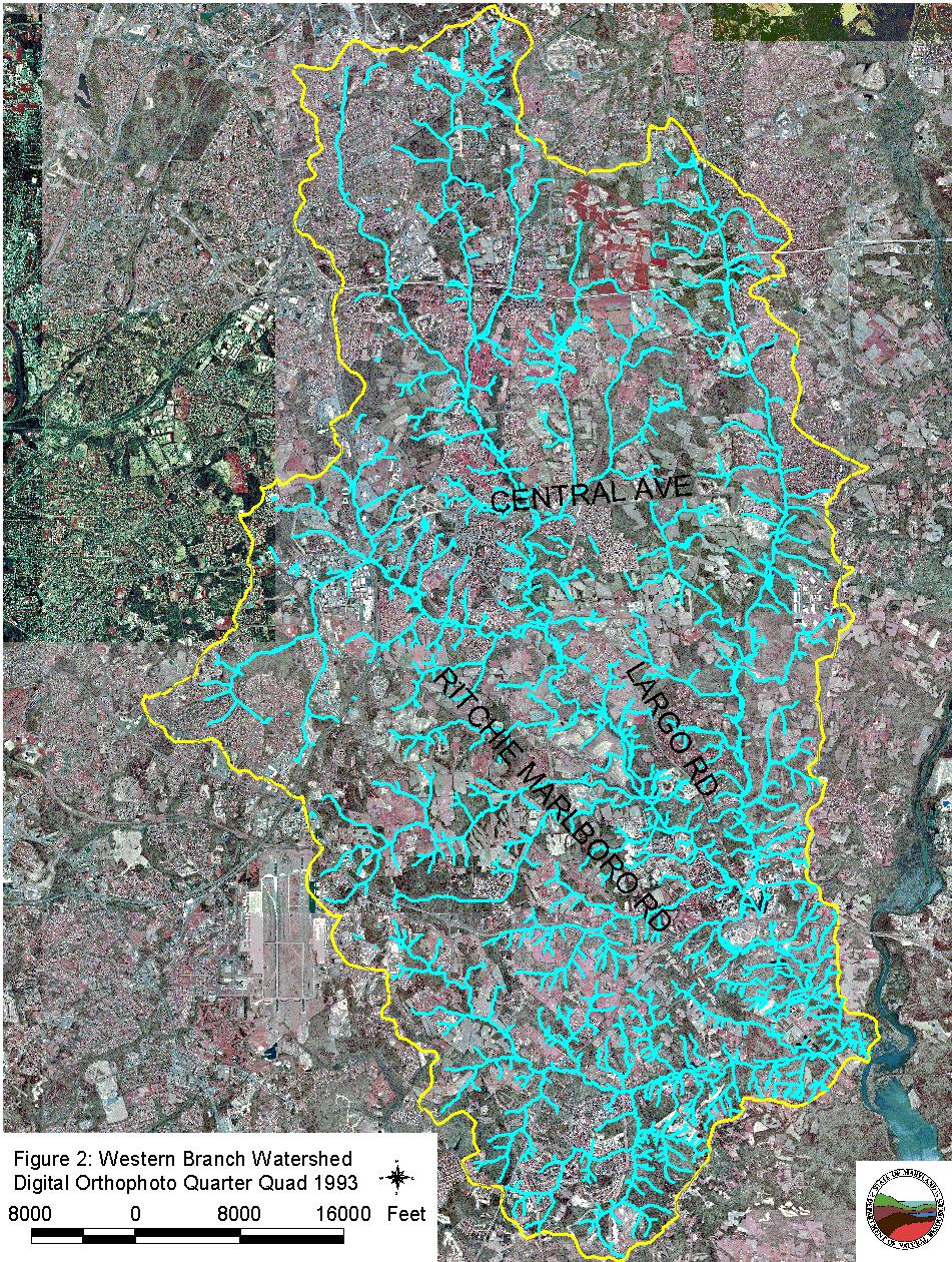
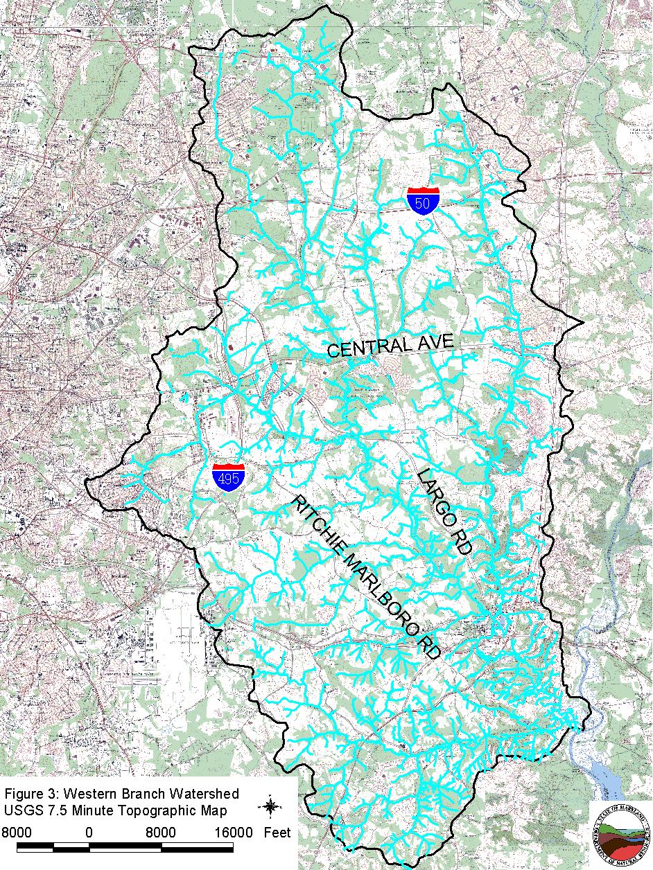
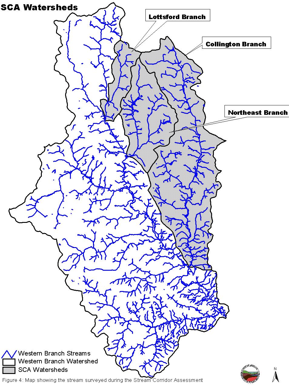
8 INTRODUCTION In 1998, Maryland s Clean Water Action Plan identified bodies of water that failed to meet water quality requirements or other natural resource goals. One of the areas identified in the report was the Western Branch watershed. The watershed encompasses approximately 71,114 acres in the Coastal Plain of Maryland. A map showing the location of the Western Branch Watershed is presented in Figure 1. In response to the findings of the Maryland Clean Water Action Plan, the Maryland Department of Natural Resources has formed a partnership with Prince George s County to work together to assess and improve environmental conditions in the Western Branch watershed. The main goals of this partnership are to develop and implement a Watershed Restoration Action Strategy (WRAS) for the Western Branch watershed. The first step in developing a Restoration Action Strategy for the Western Branch Watershed is to do an overall assessment of the condition of the watershed and the streams within it. This initial step is being accomplished using three approaches. First, a watershed characterization was done that compiles and analyzes existing water quality, land use, and living resources data about the Western Branch watershed (Shanks, 2003). Second, a synoptic water quality survey, as well as surveys of the fish and macro invertebrate communities at selected stations throughout the Western Branch Watershed were done to provide information on the present condition of aquatic resources in the watershed (Primrose, 2003). While both these approaches provide good overall information on environmental conditions within the Western Branch watershed, for the most part, information on the causes or location of specific environmental problems is limited. To provide specific information on the present location of environmental problems and restoration opportunities, a Stream Corridor Assessment (SCA) survey of the Western Branch Watershed was also done. The Stream Corridor Assessment survey has been developed by DNR s Watershed Assessment and Targeting Division as a watershed management tool to identify environmental problems and help prioritize restoration opportunities on a watershed basis. As part of the survey, members of the Watershed Assessment and Targeting Division along with specially trained personnel walk the watershed s entire stream network and record information on a variety of environmental problems that can be easily observed within the stream corridor. The Western Branch watershed in Prince George s County contains 71,114 acres (111 mi 2 ) of land. Approximately 15% (10,731 acres) of the land in the watershed is categorized as agricultural land, 39% (28,071 acres) of land is forested and 43.8% (31,341 acres) is designated as urban (Shanks, 2003). Due to funding and time limitations, the SCA survey was done in three sub-watersheds. The sub-watersheds were chosen by the WRAS committee and included Collington Branch, Lottsford Branch, and Northeast Branch in Prince George s County Maryland. The targeted area encompasses 22,581acres (39 mi 2 ) of land. Collington Branch contains 14,851 acres, Northeast Branch contains 5,549 acres, and the Lottsford Branch contains 2,181 acres. There are approximately 113 miles of stream within the three sub-watersheds. Survey teams walked all 113 miles from April 2003 to June A digital orthophoto map of watershed is shown in Figure 2. Figure 3 shows the same watershed boundary superimposed on 1
9 a seven and ½ minute USGS topographic quadrangle maps. Figure 4 shows the watershed boundaries of the three sub-watersheds. As mentioned earlier, the Maryland Department of Natural Resources is working with Prince George s County to develop a Watershed Restoration Action Strategy (WRAS) of the Western Branch Watershed. As part of this process, data collected during the SCA survey will be used to help define present environmental conditions, as well as possible restoration opportunities in the watershed. This information, combined with the watershed characterization, synoptic water quality surveys, recent biological surveys and other local knowledge of the watershed, will be used to develop a Watershed Restoration Action Strategy for the Western Branch. The Watershed Restoration Action Strategy, in turn, will help guide future restoration efforts with the ultimate goals of restoring the area s natural resources and meeting State water quality standards. 2
10 3
11 4
12 5
13 6
14 METHODS To help identify some of the common problems that affect streams in a rapid and cost effective manner, the Watershed Assessment and Targeting Division of the Maryland Department of Natural Resource has been working for the last several years to develop the Stream Corridor Assessment (SCA) survey. The four main objectives of the survey are to provide: 1. A list of observable environmental problems present within a stream system and along its riparian corridor. 2. Sufficient information on each problem so that a preliminary determination of both the severity and correctability of a problem can be made. 3. Sufficient information so that restoration efforts can be prioritized. 4. A quick assessment of both in- and near-stream habitat conditions so that comparative assessments can be made of the condition of different stream segments. It is important to note that the SCA survey is not intended to be a detailed scientific survey, nor will it replace the more traditional chemical and biological surveys. Instead, the SCA survey provides a rapid method of examining an entire drainage network so that future monitoring, management and/or conservation efforts can be better targeted. One advantage of the SCA survey over chemical and biological surveys is that the SCA survey can be done on a watershed basis both quickly and at a relatively low cost. A copy of the survey protocols is available on Department of Natural Resources web site at Maryland s SCA survey is really not a new concept but a refinement of an old approach, which in its simplest form is often referred to as a stream walk survey. Many of the common environmental problems affecting streams, such as excessive stream bank erosion or blockages to fish migration, are fairly easy to identify by an individual walking along a stream. Furthermore, an advanced degree in forestry is not needed to identify a stream segment that does not have any trees along its banks, nor does one need a degree in sanitary engineering to see that a sewage pipeline has been exposed by stream bank erosion and is leaking sewage into the stream. With a limited amount of training, most people can correctly identify these common environmental problems. As mentioned earlier, a walking survey of stream systems is not a new concept, and there have been several attempts to standardize this approach over the years. Many earlier approaches such as EPA s, Streamwalk Manual (EPA, 1992), Maryland Save our Stream s Conducting a Stream Survey, (SOS, 1970) and Maryland Public Interest Research Foundation Streamwalk Manual (Hosmer, 1988) were designed to be done by citizen volunteers with little or no training. While these surveys can be a good guide for citizens that are interested in looking at their community streams, the data collected during these surveys can vary significantly based on the background of the surveyor. In the Maryland Save our Stream Stream Survey, for example, citizen groups are given some guidance on how to organize a survey and are provided a 7
15 slide show explaining how to do the survey. After approximately one hour of training, citizen volunteers are then sent out in groups to walk designated stream segments. During the survey, volunteers usually walk their assigned stream segment in a couple of hours and return their data sheets to the survey organizers to be analyzed. While these surveys can help make communities more aware of the problems present in their local stream, citizen groups normally do not have the expertise or resources to properly analyze or fully interpret the information collected. In addition, the data collected is usually only enough to indicate that a potential environmental problem exists at a specific location but does not provide sufficient information to judge the severity of the problem. Other visual stream surveys, such as the National Resources Conservation Service s Stream Visual Assessment Protocols (NRCS, 1998), are designed for trained professionals looking at a very specific stream reach, such as at a stream passing through an individual farmer s property. While this survey can provide useful information on a specific stream segment, it is usually not done on a watershed basis. The Maryland SCA survey has been designed to bridge the gap between these two approaches. The survey is designed to be done by a small group of well-trained individuals that walk the entire stream network in a watershed. While the individuals doing the survey are usually not professional natural resource managers, they do receive several days of training in both stream ecology and SCA survey methods. While almost any group of dedicated volunteers can be trained to do a SCA survey, the Maryland Conservation Corps (MCC) has proven to be an ideal group to do this work in Maryland. The Maryland Conservation Corps is part of the AmeriCorps Program, which was started to promote greater involvement of young volunteers in their communities and the environment. DNR s Forest and Park Service manage the MCC program. Volunteers with the MCC are years old and can have educational backgrounds ranging from high school to graduate degrees. With the proper training and supervision, these young, intelligent and motivated volunteers are able to significantly contribute to the State's efforts to inventory and evaluate water quality and habitat problems from a watershed perspective. For more information on the Maryland Conservation Corps call their main office in Annapolis at (410) or visit their web site at: Prior to the start of the Western Branch SCA Survey, the members of the MCC s Chesapeake Bay Crew received several days of training. As part of this training, crewmembers learn how to identify common problems observable within the stream corridor, how to record problem locations on survey maps and how to fill out data sheets for specific problem. Procedures for documenting general stream conditions at reference sites were also reviewed during training. Reference sites are located at approximately 1/2-mile intervals along the stream. In addition to filling out a half page data sheet, field crews took photographs at all problem and reference sites to help document existing conditions. Detail information on the procedures used in the Maryland SCA survey can be found in, Stream Corridor Assessment Survey Survey Protocols (Yetman, 2001). Copies of the survey protocols can be obtained by contacting the Watershed Assessment and Targeting Division of the Maryland Department of Natural Resources in Annapolis, MD or can be downloaded from the Department s web site at 8
16 Several weeks prior to the beginning of the survey, letters were sent out to individuals who own land along the stream. The letter was used to inform property owners that the survey was being done and asked for their permission for survey crews to cross their properties. The letter also gave property owners a phone number to call if they did want more information about the survey. In addition, as part of their training survey crews were instructed not to cross fence lines or enter any areas that are marked No Trespassing unless they have specific permission from the property owner. Field surveys of the Western Branch watershed began in April 2003, and over the next several months the survey teams walked the stream s drainage network collecting information on potential environmental problems. Potential environmental problems commonly identified during the SCA Survey include: channelized stream sections, inadequate stream buffers, fish migration blockages, excessive bank erosion, near stream construction, trash dumping sites, unusual conditions, pipe outfalls. In addition, the survey records information on the location of potential wetlands creation sites and collects data on the general condition of in-stream and riparian habitats. It is not unusual for an SCA survey to identify large number of problems in each problem category. For example, in an earlier survey of the Swan Creek Watershed in Harford County, a total of 453 potential environmental problems were identified along 96 miles of stream. The most frequently reported problem during the survey was stream bank erosion, which was reported at 179 different locations (Yetman et. al., 1996). Follow up surveys found that while stream bank erosion was a common problem throughout the watershed, the severity of the erosion problem varied substantially among the sites and that the erosion problems at many sites were fairly minor. Based on this experience the SCA survey has field crews evaluate and score all problems on a scale of 1 to 5 in three separate areas: problem severity, correctability, and accessibility. A major part of the crews training is devoted to how to properly rate the different problems identified during the survey. While the ratings are subjective, they have proven to be very valuable in providing a starting point for more detailed follow-up evaluations. This is because in many cases, resource professionals such as fisheries biologists, foresters, hydrologists and engineers do not have the time to walk hundreds of miles of streams to determine where the problems are. What the SCA survey does is train the MCC and other groups to walk streams for them and collect some very basic information about commonly seen problems. Once the SCA survey has been completed, the data collected can then be used by different resource professionals to help target future restoration efforts. A regional forester for example can use data collected on inadequate stream buffers to help target future riparian buffer plantings, while the local fishery biologist can use the data on fish blockages to help target future fish passage projects to reestablish spawning runs. The inclusion of a rating system in the survey gives resource professional an idea of which sites the field crew believed were the most severe, easiest to correct and easiest to access. This information combined with photographs of the site can help resource managers focus their own follow up evaluations and fieldwork at the most important sites. A general description of the rating system is given below. More specific information on the criteria used to rate each problem category is provided in the SCA Survey Protocols (Yetman, 2000). It is important to note that the rating system is designed to contrast problems within a specific problem category. When assigning a severity rating to a site with an inadequate stream buffer for example, the rating is only intended to compare the site to other in the State 9
17 with inadequate stream buffers. The rating is not intended to be applied across categories. A trash dumping site with a very severe rating may not necessarily be a more significant environmental problem than a stream bank erosion site that received a moderate severity rating. The severity rating has generally been found to be the most useful rating and indicates how bad a specific problem is relative to others in the same problem category. The severity rating is used to answer questions such as, where are the worst stream bank erosion sites in the watershed, or where is the largest section of stream with an inadequate buffer. The scoring is based on the overall impression of the survey team of the severity of the problem at the time of the survey. * A very severe rating of 1 is used to identify problems that have a direct and wide reaching impact on the stream s aquatic resources. Within a specific problem category, a very severe rating indicates that the problem is among the worst that the field teams have seen or would expect to see. Examples would include a discharge from a pipe that was discoloring the water over a long stream reach (greater than 1000 feet) or a long section of stream (greater than 1000 feet) with high raw vertical banks that appear to be unstable and eroding at a fast rate. * A moderate severity rating of 3 is used to identify problems that appear to be having some adverse environmental impacts but the severity and/or length of stream affected is fairly limited. While a moderate severity rating would indicate that field crews did believe it was a significant problem, it also indicates that they have seen or would expect to see much worse problems in that specific problem category. Examples would include: a small fish blockage that was passable by strong swimming fish like trout, but a barrier to resident species such as sculpins; or a site where several hundred feet of stream had an inadequate forest buffer. * A minor severity rating of 5 is given to problems that do not appear to be having a significant impact on stream and aquatic resources. A minor rating indicates that a problem was present but compared to other problems in the same category it would be considered minor. Examples would include: an outfall pipe from a storm water management structure that is not discharging during dry weather and does not have any erosion problem either at the outfall or immediately downstream, or a section of stream that has stable banks and some trees along both banks but the forest buffer is less than 50 feet. The correctability rating provides a relative measure on how easily the field teams believe the problem can be corrected. The correctability rating can be helpful in determining which problems can be easily dealt with when developing a restoration plan for a drainage basin. One restoration strategy would initially target the severest problems that are the easiest to fix. The correctability rating can also be useful in identifying simple projects that can be done by volunteers, as opposed to projects that require more significant planning and engineering efforts. * A minor correctability rating of 1 is assigned to problems that can be corrected quickly and easily using hand labor, with a minimum amount of planning. These types of projects would usually not need any Federal, State or local government permits. It is a job that small group of volunteers (10 people or less) could fix in a day or two without 10
18 using heavy equipment. Examples would be removing debris from a blocked culvert pipe, removing less than two pickup truck loads of trash from an easily accessible area or planting trees along a short stretch of stream. * A moderate correctability rating of 3 is given to sites that may require a small piece of equipment, such as a backhoe, and some planning to correct the problem. This would not be the type of project that volunteers would usually do by themselves, although volunteers could assist in some aspects of the project, such as final landscaping. This type of project would usually require a week or more to complete. The project may require some local, State or Federal government notification or permits, however, environmental disturbance would be small and approval should be easy to obtain. * A very difficult correctability rating of 5 is given to problems that would require a large expensive effort to correct. These projects would usually require heavy equipment, significant amount of funding ($100, or more), and construction could take a month or more. The amount of disturbance would be large and the project would need to obtain a variety of Federal, State and/or local permits. Examples would include a potential restoration area where the stream has deeply incised several feet over a long distance (i.e., several thousand feet) or a fish blockage at a large dam. The accessibility rating is used to provide a relative measure of how difficult it is to reach a specific problem site. The rating is made at the site by the field survey team, using their field map and field observations. While factors such as land ownership and surrounding land use can enter into the field judgments of accessibility, the rating assumes that access to the site could be obtained if requested from the property owner. * A very easy accessibility rating of 1 is assigned to sites that are readily accessible both by car and on foot. Examples would include a problem in an open area inside a public park where there is sufficient room to park safely near the site. * A moderate accessibility rating of 3 is assigned to sites that are easily accessible by foot but not easily accessible by a vehicle. Examples would include a stream section that could be reached by crossing a large field or a site that was accessible only by 4-wheel drive vehicles. * A very difficult accessibility rating of 5 is assigned to sites that are difficult to reach both on foot and by a vehicle. Examples would include a site where there are no roads or trails nearby. To reach the site it would be necessary to hike at least a mile. If equipment were needed to do the restoration work, an access road would need to be built through rough terrain. 11
19 Following the completion of the survey, information from the field data sheets were entered into a Microsoft Access database and verified by the field teams. In addition, the 538 photographs were taken during the survey were labeled and organized by site number in a binder. The photographs were also digitized using a flat bed scanner and placed on a photo CD so they can be distributed to interested parties. Finally, all data collected during the survey was incorporated into an ArcView Geographic Information System (GIS). A final copy of the ArcView files was given to the Prince George s County Planning Department for their use in developing a Watershed Action Strategy for the Western Branch. 12
20 RESULTS The Stream Corridor Assessment survey of the Western Branch sub-watersheds started in April 2003, and field data collection was completed by June An overall summary of survey results is presented in Table 1, while Table 2 summarizes the data by major stream segments. All data collected during the survey is presented in Appendices A and B. Appendix A provides a listing of information by problem number along with its location, using Maryland State Plane northing and easting coordinates. The coordinates are meters. Information in this format is useful when working with maps showing the location of problem sites to determine what problems may be present along a specific stream reach. In Appendix B, the data is presented by problem type, with more detailed information about each problem. Presenting the data by problem type allows the reader to see which problems the field crews rated the most severe or easiest to fix within each category. Table 1. Summary of results from Western Branch SCA Survey. Potential Problems Identified Number Estimated Length Pipe Outfalls 128 N/A Fish Barriers 117 N/A Erosion Site ,300 feet (20.9miles) Inadequate Buffers 51 52,000 feet (9.85miles) Trash Dumping 45 N/A Unusual Conditions 20 N/A In/Near Stream Construction 14 N/A Channel Alterations 9 5,840 (1.1miles) Exposed Pipes feet (0.03miles) TOTAL Comments 6 Representative Sites 48 Very Severe Severe Moderate Low Severity Minor 13
21 Table 2 Summary of results by major stream segments. Stream Segment Channel Alteration Construction Erosion Exposed Pipes Fish Barrier Inadequate Buffer Pipe Outfall Representative Sites Trash Dumping Unusual Conditions Comments Total Collington Branch Lottsford Branch Northeast Branch
22 Pipe Outfalls Pipe outfalls include any pipes or small man made channels that discharge into the stream through the stream corridor. Pipe outfalls are considered a potential environmental problem in the survey because they can carry uncontrolled runoff and pollutants such as oil, heavy metals and nutrients to a stream system. One hundred and twenty eight pipe outfalls were identified during the Western Branch survey. The location of these pipes can be seen in Figures 5b, 5c, and 5d. Seventy percent (90) of the pipe outfalls observed in the survey had a discharge coming out of them. Of these, only 9 had an odor or coloration associated with the outfall (Appendix B). The remaining discharges were reported as having a clear discharge with no odor. Descriptions of the discharge found include medium brown, brown, green and white. Several pipes were found to contain rotten egg and fishy odors. The most frequently reported type of outfall was stormwater at 121 sites. There were no estimates of the amount of fluid discharging from the pipes. No immediate follow up actions were taken as part of this study to determine the source of color or odor discharging from the pipes. In some cases, coloration or smell from a storm drainpipe may be a sporadic occurrence. Severity ratings for pipe outfalls were given based on outfall type, discharge, and type of discharge. In the Western Branch SCA Survey there were 90 moderate and 38 minor sites (Figure 5a). The severity rating of moderate is for pipes with a discharge and the discharge is clear with no odor or if the discharge has a color and/or odor, the amount of discharge is very small compared to the stream s base flow and any impact appears to be minor and localized. (Yetman, 2001) 100 Pipe Outfalls Western Branch 80 Frequency Very Severe Severe Moderate Low Severity Minor Figure 5a: Histograph showing the frequency of severity ratings given to pipe outfall sites during the Western Branch SCA survey. 15
23 16
24 17
25 18
26 Fish Migration Barriers Fish migration barriers are anything in the stream that significantly interferes with the free movement of fish upstream. Unimpeded fish passage is especially important for anadromous fish that live much of their lives in tidal waters but must move into non-tidal rivers and streams to spawn. Unimpeded upstream movement is also important for resident fish species, many of which also move both up and down stream during different parts of their life cycle. Without free fish passage, some of the sections in a stream network can become isolated. If a disturbance occurs in an isolated stretch of stream, such as a sewage line break that discharges a large amount of raw sewage into a small tributary, some or all fish species may be eliminated from that section of stream. With a fish blockage present and no natural way for a fish to repopulate the isolated stream section, the diversity of the fish community in an area will be reduced and the remaining biological community may be out of natural balance. Fish blockages can be caused by man-made structures such as dams or road culverts and by natural features such as waterfalls or beaver dams. Fish blockages occur for three main reasons. First, a vertical water drop such as a dam can be too high for fish to jump or swim over the obstacle. A vertical drop of 6 inches may cause a fish passage problem for some resident fish species, while anadromous fish can usually move through water drops of up to 1 foot, providing there is sufficient flow and water depth. The second reason a structure may be a fish passage problem is because the water is too shallow. This can often occur in channelized stream sections or at road crossing where the water from a small stream has been spread over a large flat area and the water is not deep enough for fish to swim through. Finally, a structure may be a fish blockage if the water is moving too fast through it for fish to swim through. This can occur at road crossings where the culvert pipe has been placed at a steep angle and the water moving through the pipe has a velocity that is higher than a fish s swimming ability. Survey crews identified 117 fish migration barriers during the survey. One hundred and three fish barriers were found in Collington Branch, 5 in Lottsford Branch, and 9 in Northeast Branch. The locations of fish migration blockages are shown in Figure 6b, 6c, and 6d. Debris dams were cited as the main type of fish barrier and were reported at 42 sites. Other causes of fish barriers in the watershed were road crossings (18), beaver dams (15), in-stream ponds (10), natural falls (10), dams (8), pipe crossings (5), channelized streams (6), and railroad crossings (3). The majority (59 of 117 sites) of the fish migration blockages were characterized as being temporary fish migration barriers, blocking the whole width of the stream with a temporary structure. Total structures blocking full movement of fish were cited at 49 sites. Partial barriers allowing some flow through unimpeded were found in 10 cases. All of the fish migration barriers were given moderate to minor ratings (Figure 6a). Severity ratings were based on position in the watershed, as well as the type and height/depth of the barrier. The main stems of the three sub-watersheds are relatively barrier free except for a few minor sites. Migratory fish such as white perch and herring have been found to spawn in some areas of the Western Branch. White perch in particular was found in Collington Branch. (Mower J. and M. McGinty. 2002) 19
27 Frequency Fish Barriers Western Branch Very Severe Severe Moderate Low Severity Minor Figure 6a: Histograph showing the frequency of severity ratings given to fish barriers seen during the Western Branch SCA Survey. 20
28 21
29 22
30 23
31 Erosion Sites Erosion is a natural process, and it is necessary to maintain good aquatic habitat in a stream. Too much erosion, however, can have the opposite effect, destabilizing stream banks, destroying in-stream habitat and causing significant sediment pollution problems downstream. Severe erosion problems occur when a stream s hydrology, geometry and/or sediment supply have been significantly altered. This often occurs when land use in a watershed changes. Increases in the amount of impervious surfaces, construction in the floodplain and alterations to channel alignments can all destabilize stream banks. These activities can set off a series of channel readjustments that can extend over decades. During this time excessive amounts of sediment from the unstable eroding stream banks can have very detrimental impacts on the stream s aquatic resources. In this survey, unstable eroding streams are defined as areas where the stream banks are almost vertical and the roots from the vegetation along the stream s banks are unable to hold the soil onto banks. Unstable eroding stream banks were reported at 60 sites. The locations of erosion sites are shown in Figures 7b, 7c, and 7d, while severities can be seen in Figure 7a. It is important to note that the SCA survey is only a visual survey of the stream network. While survey teams are asked to comment whether they believed the stream was down-cutting, widening, or headcutting at a specific site, the only way to really know the full significance of the erosion processes at a specific site is to do more detailed monitoring over time. Erosion sites were mainly in Collington Branch with a few in Lottsford and Northeast Branch. There were 52 reported erosion sites in Collington Branch, 4 being reported in Lottsford Branch, and 4 in Northeast Branch. The lengths of the erosion sites reported ranged from 30 feet to 9,000 feet with heights ranging from 4feet to 8 feet. The most frequently reported causes for erosion were: land use changes upstream (7), road crossing (14), crop field runoff (1), and unknown (31). 40 Erosion Sites Western Branch Frequency Very Severe Severe Moderate Low Severity Minor Figure 7a: Histograph showing the frequency of severity ratings given to stream bank erosion sites during the Western Branch SCA Survey. 24
32 Collington Branch Collington Branch contains 52 erosion sites as identified by this survey. Seven of these erosion sites were given very severe ratings. At site WB384201, the survey crew reported that the stream appeared to be widening causing severe erosion. The average height of the banks was 12 feet and the erosion problems ran for approximately 9,000 feet with forest on both sides of stream. At site WB average bank heights were reported to be 6 feet and erosion problems could be seen over approximately 6,400 feet long section of stream with forest on both sides. At site WB414201, the average heights of the stream bans were 10 feet and the problem extended over a 5,000 feet section of stream. Field crews reported forest to be the dominant adjacent land use. At site WB average bank heights were reported to be 13 feet and erosion problems could be seen over approximately 1,800 feet long section of stream with paved and each side of the stream. Field crews also noted that a gas station was near the erosion site and could be threatened. At site WB average bank heights were reported to be 12 feet and erosion problems could be seen over approximately 1,700 feet long section of stream with forest on both sides. Finally, at site WB343104, the field crew found a 1,200 feet section of stream with 8 feet high banks running through an area with lawn on both sides. Lottsford Branch Lottsford Branch contains 4 erosion sites as identified by this survey. None of these sites were given a very severe or severe rating. Only one site was given a moderate rating. At site WB112401, the average height of the stream banks was 3 feet and the problem extended for approximately 1,400 feet with forest present on both sides of the stream. Northeast Branch Four erosion sites were identified in the Northeast Branch sub-watershed. Only one of these sites received a very severe rating. At site WB236403, average bank height was 6 feet and extended over 2,800 feet long with forest on both sides. One site received a severe rating. Site had an average bank height of 6 feet and was over 1,200 feet long with forest on both sides. 25
33 26
34 27
35 28
36 Inadequate Buffers Forested stream buffers are very important for maintaining healthy Maryland streams. They help shade the stream to prevent excessive solar heating and their roots stabilize the streams banks. Forest buffers also help remove nutrients, sediment and other pollutants from runoff, and the leaves from trees are a major component of the stream s food web. Because of the importance of stream buffers, the state of Maryland has set a goal of recreating 1,200 miles of forest stream buffers by the year While there is no single minimum standard for how wide a forested stream buffer should be in Maryland, for the purposes of this study a forest buffer is generally considered inadequate if it is less than 50 feet wide, measured from the edge of the stream s banks. Inadequate buffers were the third most frequently reported problem. Survey crews reported inadequate stream buffers at 54 sites in the Western Branch watershed survey. The locations of the inadequate buffer sites are shown in Figure 8b, 8c, and 8d. As part of the data collected by the field crews, a rough estimate of the length of the inadequate stream buffer at each site was made. Based on this data, there is an estimated 52,000 feet (9.85 miles) of inadequately buffered stream banks in the Collington Branch, Lottsford Branch, and Northeast Branch sub-watersheds. This accounts for 8.7% of the total stream miles that were surveyed by the field crews. The length of inadequate buffers ranged from 100 feet to 5,000 feet. At 30 sites, the field crew reported that there were no trees on both sides of the stream, while at an additional 21 sites trees were present on only one side of the stream. The most commonly reported land use along these inadequately buffered banks was lawn at 19 sites. Four sites were reported to have livestock present. The very severe sites involve areas were the inadequately buffered area totaled over 1000 feet of stream with no buffer on either stream bank. The severe sites were sites in which there were no buffer on either side for 500 feet 1000 feet long, or sites where there was a buffer on one side and inadequate buffer on the other for over 1000 feet. 20 Inadequate Buffers Western branch 15 Frequency Very Severe Severe Moderate Low Severity Minor Figure 8a: Histograph showing the frequency of severity ratings given to inadequate buffers during the Western Branch SCA Survey. 29
37 30
38 31
39 32
40 Trash Dumping Trash dumping data sheets record information on places where large amounts of trash have been dumped inside the stream corridor, or to note places where trash tends to accumulate. The field survey crew found 45 sites where there was excessive trash, and these locations are shown in Figures 9b, 9c, and 9c. The sites were given severity ratings based on size, contents of trash, and potential impact on the stream. Severity ratings for trash dumping sites throughout the surveyed Western Branch sub-watersheds can be found in Figure 9a. Most sites found were ranked as moderate to minor trash dumping sites. Field crews indicated that 28 of the sites might be good volunteer clean up opportunities. Trash dumping sites in the Collington Branch, Lottsford Branch, and Northeast Branch sub-watersheds range in size from 1 to 14 pickup truckloads and for sites with other measures, 3 to12 dump truck loads. Single site trash dumping sites were recorded at 25 sites, while large area dumping sites were recorded at 20 locations. Types of trash sites found include: residential (23), tires (3), yard waste (5), floatables (3), construction materials (3), and mixed (7). Site was the only site to be given a very severe rating. An estimated 8 dump truck loads of mixed types of trash. This included appliances, tires, and auto parts. 20 Trash Dumpings Western Branch 15 Frequency Very Severe Severe Moderate Low Severity Minor Figure 9a: Histograph showing the frequency of severity ratings given to trash dumping sites seen during the Western Branch SCA survey 33
41 34
42 35
43 36
44 Unusual Conditions The unusual condition/comment data sheets are used to record the location of anything out of the ordinary seen during the survey or to provide some additional written comments on a specific problem. Twenty unusual conditions were reported during the Western Branch survey, and six additional comments were recorded. The locations of the unusual conditions and comments can be found in Figures 10b, 10c, and 10c. Severities of the unusual conditions found during the Western Branch survey can be seen in Figure 10a. Collington Branch Thirteen unusual conditions were recorded in the Collington Branch sub-watershed. Site WB was given a very severe rating. At this site, the field crews noted an oil puddle near a construction area. It was noted by field crews that this is probably due to construction equipment near the stream. Lottsford Branch Three unusual condition sheets were recorded in the Lottsford Branch sub-watershed. Two of the unusual conditions were recorded as moderate sites. At site WB105107, the crew reported a small oil puddle near a construction site. At site WB115402, there is a stream piped for 150 feet. Northeast Branch Four unusual condition sheets were recorded in the Northeast Branch. One of these sites was identified as a moderate site. At site WB247101, a stream is pipe for approximately 2,200 feet. 10 Unusual Conditions Western Branch 8 Frequency Very Severe Severe Moderate Low Severity Minor Figure 10a: Histograph showing the frequency of severity ratings given to unusual conditions seen during the Western Branch SCA survey. 37
45 38
46 39
47 40
48 In/Near Stream Construction In or near stream construction data sheets are used to document any construction disturbances seen by the survey teams inside or near the stream corridor. Survey team members are not trained sediment inspectors, but as part of their training they do receive a quick review of the different type of sediment control measures they may see while doing a SCA survey. Survey teams report evidence of inadequate sediment control measures or if sediment pollution from the site has affected the stream. In or near stream construction was reported at 14 sites during the Western Branch survey. The locations of in/near stream construction sites are shown in Figure 11b, 11c, and 11d. Collington Branch There were 10 sites reported to have in/near stream construction in Collington Branch. Two sites were given very severe ratings. At site WB402101, in some areas silt fence was nonexistent and in places where there was silt fence it looked to be failing. Excess sediment in the stream was also reported. At site WB402403, the vegetation was removed along the stream and silt fencing was not present. Excess sediment in the stream was also reported at this site. Lottsford Branch There were three sites reported to have in/near stream construction in Lottsford Branch. Only one received a moderate rating. At site WB there was a break in the silt fence and there was excess sediment in the stream. Northeast Branch There was only one site reported in Northeast Branch. Site WB was given a moderate rating. At the site there was a break in the silt fence and there was excess sediment in the stream. Frequency In/Near Stream Construction Western Branch 0 Very Severe Severe Moderate Low Severity Minor Figure 11a: Histograph showing the frequency of severity ratings of In/Near Stream Construction sites seen during the Western Branch SCA survey. 41
49 42
50 43
51 44
52 Channel Alterations Channel alteration sites are stream sections where the stream s banks and channel have been significantly altered from a natural condition. This includes areas where the stream may have been straightened and/or where the stream banks have been hardened using rock, gabion baskets or concrete over a significant length. It does not include road crossings unless a significant portion of the stream above or below the road has also been channelized. In addition, places where a small section of only one side of the stream s banks may have been stabilized to reduce erosion were not reported as channel alterations. For the purposes of this survey, channel alteration also does not include tributaries where storm drains were placed in the stream channel, and the entire tributary is now piped underground. While these stream sections have been significantly altered, it is not possible to tell by walking the stream corridor precisely where this was done. In the three surveyed sub-watersheds of the Western Branch watershed, survey crews found 9 areas where the stream channel had been recognizably altered. Locations of channel alteration sites are shown in Figure 12b,and 12c. The total length of stream affected by channelization was estimated to be 5,845 feet, or about 1.1 miles. The majority of the sites were rip-rap channels (4), and earth channels (3). Other sites were found to be a concrete channel (1) and a vinyl plastic sheet (1). Perennial flow was reported at all 9 sites, and sediment deposition was reported at 4 sites. Vegetation was found in the channel at 3 sites. Most of the sites in the Western Branch watershed were given low severity ratings (Figure 12a). There were only two sites that received very severe ratings. Site WB is a concrete channel that is 1,800 feet long. At site WB the stream has been placed in a channel lined with black plastic sheeting. Both if these channels are open to the sunlight. Such channels are prone to thermal heating, which contributes to a decline in in-stream aquatic populations. 5 Channel Alterations Western Branch 4 Frequency Very Severe Severe Moderate Low Severity Minor Figure 12a: Histograph showing the frequency of severity ratings given to channel alteration sites during the Western Branch SCA Survey. 45
Patapsco River. Survey
 Channel Alteration Inadequate Buffer Erosion Fish Migration Barrier Pipe Outfall Exposed Pipes Trash Dumping Unusual Condition In/Stream Construction Channel Alteration Inadequate Buffer Channel Alteration
STREAM BANK STABILIZATION THORPS MORTIMER RECREATION AREA Grandfather Ranger District SITE LOCATION & DRAINAGE AREA
 STREAM BANK STABILIZATION THORPS CREEK @ MORTIMER RECREATION AREA SITE LOCATION & DRAINAGE AREA SITE LOCATION Drainage Area = 1.14 sq. miles STREAM BANK STABILIZATION THORPS CREEK @ MORTIMER RECREATION
North Branch of Cypress Creek Ecological Restoration: A Comprehensive Approach to Stream Restoration
 North Branch of Cypress Creek Ecological Restoration: A Comprehensive Approach to Stream Restoration Rocky Powell Clear Creeks Consulting, LLC Keith D. Tate, P.E. BayLand Consultants & Designers, Inc.
ST. MARY S SOIL CONSERVATION DISTRICT (SMSCD) AND DPW&T CONCEPT EROSION AND SEDIMENT CONTROL AND STORMWATER MANAGEMENT GUIDELINES AND CHECKLIST
 AND DPW&T CONCEPT EROSION AND SEDIMENT CONTROL AND STORMWATER MANAGEMENT GUIDELINES AND CHECKLIST") St. Mary s Soil Conservation District 26737 Radio Station Way, Suite B Leonardtown, MD 20650 Phone: 301-475-8402 ext. 3 Fax: 301-475-8391 www.stmarysscd.com St. Mary s County Government Department of Public
St. Mary s Soil Conservation District 26737 Radio Station Way, Suite B Leonardtown, MD 20650 Phone: 301-475-8402 ext. 3 Fax: 301-475-8391 www.stmarysscd.com St. Mary s County Government Department of Public
Chesapeake Bay Critical Area Conservation Plan
 The Maryland-National Capital Park and Planning Commission Prince George s County Planning Department Development Review Division 301-952-3530 Note: Staff reports can be accessed at www.mncppc.org/pgco/planning/plan.htm.
ADDENDUM TO BIOLOGICAL SCOPING SURVEY REPORT, BOTANICAL SURVEY AND WETLAND DELINEATION
 ADDENDUM TO BIOLOGICAL SCOPING SURVEY REPORT, BOTANICAL SURVEY AND WETLAND DELINEATION FOR AVALON INN (APN 069-241-27 & -04) 1201 & 1211 NORTH MAIN STREET FORT BRAGG, CA MENDOCINO COUNTY prepared for:
Chapter 3 Site Planning and Low Impact Development
 CHAPTER 3 Site Planning and Low Impact Development Chapter 3 Site Planning and Low Impact Development 3.0 Introduction The City of Charleston requires that major residential, large commercial (>1 acre),
Design Considerations for Open Channel and Detention Pond Design. Howard Redfearn, City of Mansfield
 Design Considerations for Open Channel and Detention Pond Design Howard Redfearn, City of Mansfield Previous Experience/Criteria/Maintenance Issues New Criteria Discussion Overview Where is Mansfield?
When planning stormwater management facilities, the following principles shall be applied where possible.
 2.0 Principles When planning stormwater management facilities, the following principles shall be applied where possible. 2.0.1 Drainage is a regional phenomenon that does not respect the boundaries between
Wisconsin NRCS Direct Volume Method Bank Recession Rate Categorizations
 2 Executive Summary The City of Ramsey contracted the Anoka Conservation District to complete an inventory of riverbank condition along the entire 5.8 miles of City that border the Mississippi River. The
Severn River Sub-Watershed: BMP 09-Retrofit
 Project ID: BMP_09 Total Treated Drainage Area: 4.57 acres Total Treated Impervious Area: 2.9 acres Total Water Quality Volume (WQv): ~10,300 cubic feet; 0.236 acre-foot Rainfall Depth Treated (Pe): 1
Checklists. Project Name: Location: File Number: Date of Submittal: Reviewer: Date: Applicant: Contact Name: Phone Number:
 Applicant: Contact Name: Phone Number: Email: Project Name: Location: File Number: Date of Submittal: Reviewer: Date: Concept Plan Requirements: I. General Project Information 1. Address or parcel number
STREAM BUFFERS
 88-415 STREAM BUFFERS 88-415-01 PURPOSE In the Kansas City region and throughout the nation, vegetated stream buffers have been clearly shown to protect stream stability and related infrastructure, improve
OVERMOUNTAIN VICTORY TRAIL BURKE CALDELL CORRIDOR FEASIBLITY STUDY REQUEST FOR QUALIFICATIONS CALDWELL COUNTY PATHWAYS
 OVERMOUNTAIN VICTORY TRAIL BURKE CALDELL CORRIDOR FEASIBLITY STUDY REQUEST FOR QUALIFICATIONS CALDWELL COUNTY PATHWAYS Caldwell County Pathways along with our co-partners City of Lenoir, Town of Gamewell,
Arkansas River Corridor
 Planning for Access Welcome to the Access Project. This project is a recreational planning effort in response to an interest by regional communities along the Arkansas River corridor. The project plan
Chapter 4 - Preparation of Stormwater Site Plans
 Chapter 4 - Preparation of Stormwater Site Plans The Stormwater Site Plan is the comprehensive report containing all of the technical information and analysis necessary for the City to evaluate a proposed
WASHINGTON COUNTY OREGON
 WASHINGTON COUNTY OREGON LONG RANGE PLANNING DIVISION North Bethany Subarea Stream Corridors: Existing Regulations In Oregon, there is a distinct difference between the land use rules that apply in rural
Weston s Wetlands, Stormwater, & Open Space
 Weston s Wetlands, Stormwater, & Open Space Weston s Wetlands, Stormwater, & Open Space Conservation Commission Role and Responsibilities Laws that protect wetlands What residents can do to protect wetlands
Zoning Ordinance Article 3
 Article 3 Natural Resources Protection Section 301 Natural Resources Protection 301.1. Purpose - The following natural resources protection standards are established to protect the public health, safety
Erosion Control for Home Builders in the. City of Jacksonville
 Erosion Control for Home Builders in the City of Jacksonville Eroding construction sites are a leading cause of water quality problems in Jacksonville. For every acre under construction, about a dump truck
PROJECT SCOPE OF WORK CITY OF TOWN AND COUNTRY STORMWATER PROGRAM
 PROJECT SCOPE OF WORK CITY OF TOWN AND COUNTRY STORMWATER PROGRAM Project ID Number: 25-5 Problem: Stormwater collected from the neighborhood upstream is released at 9 Muirfield Lane and flows west toward
5. FINAL DEVELOPMENT PLAN APPROVAL MENORAH MEDICAL CENTER OFFICE BUILDING Vicinity of the southwest corner of 119 th Street and Nall Avenue
 5. FINAL DEVELOPMENT PLAN APPROVAL MENORAH MEDICAL CENTER Avenue 1. APPLICANT: Hoefer Wysocki Architects, L.L.C., is the applicant for this request. 2. REQUESTED ACTION: The applicant is requesting final
City of Stoughton Erosion Control Permit Application (effective 2/6/2018)
") City of Stoughton Erosion Control Permit Application (effective 2/6/2018) Incomplete applications will not be accepted Project Name: Address of subject property: Landowner Name(s): Applicant Name: Landowner
City of Stoughton Erosion Control Permit Application (effective 2/6/2018) Incomplete applications will not be accepted Project Name: Address of subject property: Landowner Name(s): Applicant Name: Landowner
SECTION 6. Routine Maintenance Activity Details
 SECTION 6 Routine Maintenance Activity Details 80. DEBRIS REMOVAL When Deadfall, and other objects, such as shopping carts, tires, appliances, and mattresses have accumulated in the drain. Why To prevent
Town of Vershire Road Erosion Inventory Report
 Town of Vershire Road Erosion Inventory Report Taylor Valley Road. Photo taken by TRORC staff. Prepared by: 128 King Farm Road Woodstock, VT 05091 Inventory and report funded by the Vermont Agency of Transportation
7.0 SOCIAL, ECONOMIC, AND ENVIRONMENTAL ISSUES
 7.0 SOCIAL, ECONOMIC, AND ENVIRONMENTAL ISSUES The following list of social, economic, and environmental issues have been identified based on a preliminary inventory of resources in the project area, an
Rain Gardens. A Welcome Addition to Your Landscape
 Rain Gardens A Welcome Addition to Your Landscape Where Does The Rainwater Go? Naturally, forests provide a way for rainwater to percolate into the soil, filtering pollutants while trees are allowed to
Lake and Stream Restoration Project
 Pre-project Fact Sheet May 2012 Toledo Botanical Garden (TBG) is a 60 acre public garden visited by more than 120,000 people annually. It is located in Toledo, Ohio in the Ottawa River watershed within
Rule D Wetland and Creek Buffers
 Rule D Wetland and Creek Buffers 1 Policy It is the policy of the Board of Managers to ensure the preservation of the natural resources, recreational, habitat, water treatment and water storage functions
STORMWATER SITE PLAN INSTRUCTIONS AND SUBMITTAL TEMPLATE Medium and Large Projects
 DEPARTMENT OF COMMUNITY DEVELOPMENT 621 Sheridan Street, Port Townsend, WA 98368 Tel: 360.379.4450 Fax: 360.379.4451 Web: www.co.jefferson.wa.us/communitydevelopment E-mail: dcd@co.jefferson.wa.us STORMWATER
Draft Rhode Island Stormwater Design and Installation Standards Manual
 Draft Rhode Island Stormwater Design and Installation Standards Manual Summary The May 2009 Public Review Draft version of the RI Stormwater Design and Installation Standards Manual consists of approximately
Natural Shoreline Landscapes on Michigan Inland Lakes. Introduction. Workshop for Property Owners. Photo by Jane Herbert
 Natural Shoreline Landscapes on Michigan Inland Lakes Workshop for Property Owners Introduction Photo by Jane Herbert MSU is an affirmative action, equalopportunity employer. Michigan State University
Northern Branch Corridor DEIS December 2011
 16 Floodplains 161 Chapter Overview 1611 Introduction The flowing chapter identifies floodplains found within the Northern Branch Corridor in accordance with Executive Order 11988, Floodplain Management
PURPOSE: The purpose is to provide commercial facilities in the Vancouver and Clark County vicinity.
 US Army Corps of Engineers Seattle District Joint Public Notice Application for a Department of the Army Permit and a Washington Department of Ecology Water Quality Certification and/or Coastal Zone Management
Vegetated Filter Strips and Buffers
 3.15 Sediment Control Description: Buffer strips (existing vegetation) and filter strips (planted vegetation) are sections of vegetated land adjacent to disturbed areas. They are designed with low slopes
Chapter 1: General Program Information
 Chapter 1: General Program Information 1.1 Introduction The Montgomery County Stormwater Management Resolution (#03-1-5) was adopted by the County Board of Commissioners on January 22, 2003. The purpose
As a homeowner in the Pacific Northwest, you
 Archival Copy. For current information, see the OSU Extension Catalog:https://catalog.extension.oregonstate.edu Taking Care of streams in Eastern Washington, A Homeowner s Guide to Riparian Areas PNW 557
Vegetated Filter Strips and Buffers
 3.15 Sediment Control Description: Buffer strips (existing vegetation) and filter strips (planted vegetation) are sections of vegetated land adjacent to disturbed areas. They are designed with low slopes
Shelbyville, KY Stormwater Best Management Practices. Section 2 EROSION PREVENTION AND SEDIMENT CONTROL PLAN
 Section 2 EROSION PREVENTION AND SEDIMENT CONTROL PLAN 2.1 Requirements The City of Shelbyville, KY will require an Erosion Prevention and Sediment Control (EPSC) Plan for most types of development construction.
The use of low head weirs to. perennial streams with their floodplains:
 The use of low head weirs to reconnect severely entrenched perennial streams with their floodplains: An Anne Arundel County TMDL Watershed Implementation Plan Strategy presented by Hala Flores, P.E Mid
VALLEY VIEW POND Q&A. This item will be discussed under the First Reading portion of the agenda at the July 17, 2012 Village Council meeting.
 VALLEY VIEW POND Q&A This item will be discussed under the First Reading portion of the agenda at the July 17, 2012 Village Council meeting. 1. Please provide a history of the pond including Village maintenance
Poisoned Park? How Exide s Lead Contamination Risks Frisco s Grand Park
 Frisco City Hall has big plans to transform Stewart Creek into a Grand Park with lots of water features for kids to play in. Poisoned Park? How Exide s Lead Contamination Risks Frisco s Grand Park But
Stream Corridor Management Plan
 Stream Corridor Management Plan A unified and comprehensive approach to protecting, restoring and managing the Upper Delaware River Graydon Dutcher Delaware County Soil and Water Conservation District
THE CITY OF DELAWARE, OHIO ILLICIT DISCHARGE DETECTION AND ELIMINATION PLAN
 THE CITY OF DELAWARE, OHIO ILLICIT DISCHARGE DETECTION AND ELIMINATION PLAN OCTOBER 2014 Table of Contents Section 1.0 Overview/Background... 1 Section 2.0 - General Permit Information... 2 Section 3.0
INTRODUCTION PLANNING HISTORY
 INTRODUCTION The Upper Rock Creek Master Plan Area lies in the east central part of Montgomery County. The Master Plan Area is adjacent to the City of Rockville to the south, the Olney Planning Area to
Problem Understanding
 Introduction...2-1 Previous Data and Mapping...2-2 Known Problem Areas...2-3 Resident Survey.2-3 Introduction The Village of Downers Grove stormwater system includes storm sewers, streams, wetlands, roadway
Guiding Landowners in Stream Restoration. The Science, Practice & Art of Restoring Native Ecosystems 2015
 Guiding Landowners in Stream Restoration The Science, Practice & Art of Restoring Native Ecosystems 2015 January 24, 2015 Guiding Landowners in Stream Restoration January 24, 2015 Agenda 1Watershed Planning
CHAPTER 3 REGULATED LAND-DISTURBING ACTIVITIES AND APPLICABLE REQUIREMENTS
 CHAPTER 3 REGULATED LAND-DISTURBING ACTIVITIES AND APPLICABLE REQUIREMENTS 3.1 INTRODUCTION As discussed in Chapter 1, development in Henrico County is subject to numerous environmental programs required
5 TH ANNUAL CAPE COASTAL CONFERENCE COONAMESSETT RIVER RESTORATION PROJECT. Elizabeth H. Gladfelter, Ph.D. Conservation Commission Town of Falmouth
 5 TH ANNUAL CAPE COASTAL CONFERENCE COONAMESSETT RIVER RESTORATION PROJECT Elizabeth H. Gladfelter, Ph.D. Conservation Commission Town of Falmouth Mural by Teaticket Elementary School 2 nd graders, Spring
JOINT PUBLIC NOTICE. 26 June United States Army Corps of Engineers State of Louisiana
 JOINT PUBLIC NOTICE 26 June 2017 United States Army Corps of Engineers State of Louisiana New Orleans District Department of Environmental Quality Regulatory Branch Office of Environmental Services 7400
Juneau Watershed Partnership
 Juneau Watershed Partnership Native Plant Resource Center Final Report A Partners for Fish and Wildlife Project Prepared for: U.S. Fish and Wildlife Service For Grant #F11C00552 Prepared by: The Juneau
Boardman River Watershed VILLAGE OF KALKASKA. WATER QUALITY ACTION PLAN Fall 2009
 Boardman River Watershed VILLAGE OF KALKASKA WATER QUALITY ACTION PLAN Fall 2009 Partners: The Watershed Center Grand Traverse Bay Northwestern Michigan College - Great Lakes Water Studies Institute Grand
Working with nature to manage your stream
 Working with nature to manage your stream Issued by Auckland Council March 2013 If you have any questions about this information sheet please contact Auckland Council on 09 301 0101 A stream in a property
Green Infrastructure. NYS Department of Environmental Conservation
 Green Infrastructure Green infrastructure is an interconnected network of natural areas and open spaces that sustains ecosystems. Benedict, M.A. and E.T. McMahon. 2006. Green Infrastructure Linking Landscapes
Western Pennsylvania Conservancy Clairton & Harrison Community Greening Assessment Projects Request for Proposals July 2018
 Western Pennsylvania Conservancy Clairton & Harrison Community Greening Assessment Projects Request for Proposals July 2018 Proposal Information The Western Pennsylvania Conservancy (WPC) is seeking proposals
ROGUE VALLEY SEWER SERVICES STORMWATER MANAGEMENT PROGRAM (SWMP)
") ROGUE VALLEY SEWER SERVICES STORMWATER MANAGEMENT PROGRAM (SWMP) 1.0 INTRODUCTION This Stormwater Management Program (SWMP) for Rogue Valley Sewer Services (RVS) has been developed to meet the Municipal
ROGUE VALLEY SEWER SERVICES STORMWATER MANAGEMENT PROGRAM (SWMP) 1.0 INTRODUCTION This Stormwater Management Program (SWMP) for Rogue Valley Sewer Services (RVS) has been developed to meet the Municipal
Restoring Water Ecosystems in NYC Parks
 Restoring Water Ecosystems in NYC Parks Hooked on our Waters Con October 19, 2013 - CUNY Graduate Center Marit Larson NYC Parks Landscape and ecosystem focus Watershed Streams Freshwater wetlands Tidal
Section 3 Non-Structural BMPs
 3.1 Stream Buffers A stream buffer or stream setback is a designated area around a stream, lake, or wetland left in a natural, densely vegetated state so as to protect the receiving water quality and provide
Stormwater Regulations & Considerations Morse Study Area. Pam Fortun, P.E. CFM Senior Stormwater Treatment Engineer Engineering Services Division
 Stormwater Regulations & Considerations Morse Study Area Pam Fortun, P.E. CFM Senior Stormwater Treatment Engineer Engineering Services Division Stormwater Regulations Development Considerations Floodplain
APPENDIX A SIMPLIFIED APPROACH TO STORMWATER MANAGEMENT FOR SMALL PROJECTS. In West Sadsbury Township, Chester County, Pennsylvania
 APPENDIX A SIMPLIFIED APPROACH TO STORMWATER MANAGEMENT FOR SMALL PROJECTS In West Sadsbury Township, Chester County, Pennsylvania TABLE OF CONTENTS I. Introduction 3 II. Importance of Stormwater Management
Working Group Meeting
 April 4,, 2017 Parks Operations Bldg Working Group Meeting Arts Districts Overview Stormwater/RPA/Stream Considerations First Principles Agenda 7:00pm 7:05pm 7:10pm 7:40pm 8:30pm 9:40pm 9:45pm Welcome
319 Grant: Baker Creek & Centenary Creek Restoration Initiative
 319 Grant: Baker Creek & Centenary Creek Restoration Initiative Objectives: Overview of Watershed Characteristics: Discussion of Project Tasks: Discussion of Watershed Management Plan: Presented by: Erich
Preface. Erie. Scranton. Allentown. Pittsburgh. Harrisburg. Philadelphia
 The Southern Alleghenies Region The Southern Alleghenies Region spans the Laurel Highlands and Allegheny Front in the west across the Appalachians to the east. It is comprised of Blair, Bedford, Cambria,
Appendix I. Checklists
 Appendix I Checklists Town of Greenwich Drainage Manual Department of Public Works - Engineering Division Town Hall - 101 Field Point Road, Greenwich, CT 06836-2540 Phone 203-622-7767 - Fax 203-622-7747
Town of Corinth Road Erosion Inventory Report
 Town of Corinth Road Erosion Inventory Report Grist Mill Road. Photo taken by TRORC staff. Prepared by: 128 King Farm Road Woodstock, VT 05091 Inventory and report funded by the Vermont Agency of Transportation
6.5 Lakewood Gulch. Basin Snapshot
 6.5 Lakewood Gulch The Lakewood Gulch Map Unit is comprised of both Lakewood Gulch and Dry Gulch (4800-01 and 4801-01) from the Denver Storm Drainage Master Plan (SDMP) and has a total drainage area of
RAIN GARDEN ILLINOIS URBAN MANUAL PRACTICE STANDARD. (feet) CODE 897 DEFINITION
 CODE 897 DEFINITION") ILLINOIS URBAN MANUAL PRACTICE STANDARD RAIN GARDEN (feet) CODE 897 Source: Kendall County Soil and Water Conservation District DEFINITION Rain gardens are small, shallow, flat bottomed depressions constructed
ILLINOIS URBAN MANUAL PRACTICE STANDARD RAIN GARDEN (feet) CODE 897 Source: Kendall County Soil and Water Conservation District DEFINITION Rain gardens are small, shallow, flat bottomed depressions constructed
Erosion & Sediment Control Plan Application Form & Checklist
 Erosion & Sediment Control Plan Application Form & Checklist GENERAL INFORMATION Application Date: Project Address: Tax Map / Parcel Number(s): PROPERTY OWNER / DEVELOPER Firm Name: Contact Person: Title:
CONSERVATION ELEMENT GOALS, OBJECTIVES, AND POLICIES
 CONSERVATION ELEMENT GOALS, OBJECTIVES, AND POLICIES Goal 4 To conserve, manage, appropriately use and protect the natural resources of the City ensuring continued resource availability and environmental
Property Owner s Guide to Creek and Shoreline Maintenance
 2014 Property Owner s Guide to Creek and Shoreline Maintenance City of O Fallon This guide for homeowners of creekside property is intended to serve as a reference for helping homeowners understand what
PROJECT SCOPE OF WORK CITY OF TOWN AND COUNTRY STORMWATER PROGRAM
 PROJECT SCOPE OF WORK CITY OF TOWN AND COUNTRY STORMWATER PROGRAM Project Name: 362 Featherstone Dr Project ID Number: 27-3 Problem: Anecdotal evidence suggests a natural spring exists in the backyard
FURTHER TO EXECUTIVE COMMITTEE MEETING #11/12 To be held on Friday, January 11, 2013
 FURTHER TO EXECUTIVE COMMITTEE MEETING #11/12 To be held on Friday, January 11, 2013 FURTHER TO: Pages EX10. APPLICATION FOR PERMITS UNDER ONTARIO REGULATION 166/06 Development, Interference with Wetlands
Principles for Ecological Landscape Design in Brownfield Business Parks
 Principles for Ecological Landscape Design in Brownfield Business Parks Part of USDA Forest Service research project # 00-JV-11231300-033: Aligning Social and Ecological Drivers of Urban Landscape Change
Rocky Areas Project Guidance HABITAT
 Rocky Areas Project Guidance HABITAT Introduction Rocky habitats are surface areas dominated by exposed rock, such as mountain peaks, inland cliffs, buttes and rocky outcrops. In many cases, rocky areas
STORMWATER UTILITY FREQUENTLY ASKED QUESTIONS
 STORMWATER UTILITY FREQUENTLY ASKED QUESTIONS What is Stormwater? Stormwater is water that falls to the ground during a precipitation event. When land is undeveloped or covered with vegetative surface,
Tentatively Selected Plan within Harlem River, East River and Western Long Island Sound Planning Region. First Level Costs. Federal Non-Federal Total
 HARLEM RIVER, EAST RIVER AND WESTERN LONG ISLAND SOUND PLANNING REGION Flushing Bay and Creek Ecosystem Restoration Source Feasibility Study Background Study Resolution (1994), Reconnaissance Report (1996),
Lincoln 270. City of Lincoln. Stormwater Management Plan. April 2, 2013
 Lincoln 270 City of Lincoln Stormwater Management Plan April 2, 2013 # 2005.48 Prepared By: Civil Engineering Solutions, Inc. 590 E Street Lincoln, Ca 95648 (916) 645 5700 1.0 Background: The project site
MANUAL OF DESIGN, INSTALLATION, AND MAINTENANCE REQUIREMENTS FOR STORMWATER MANAGEMENT PLANS
 MANUAL OF DESIGN, INSTALLATION, AND MAINTENANCE REQUIREMENTS FOR STORMWATER MANAGEMENT PLANS May 2007 SECTION 1 Responsibility of Applicant TABLE OF CONTENTS A. Stormwater Management Plan Required Information
The Development of Riparian Stream Buffers in Greensboro, NC
 The Development of Riparian Stream Buffers in Greensboro, NC Why our stream banks have grown up? Presented by: Peter Schneider, Water Quality Supervisor City of Greensboro Stormwater Management Division
2011 ASLA Design Awards. Coyote Gulch Honor Award and Land Stewardship Designation Valerian LLC. Environmental Restoration and Reclamation
 2011 ASLA Design Awards Honor Award and Land Stewardship Designation Valerian LLC Environmental Restoration and Reclamation Project Name: Category : Project Location: 5 2011 Environmental Restoration and
HUDSON VALLEY REGIONAL COUNCIL 3 Washington Center, Newburgh NY
 PROJECT AREA: HYDE PARK HUDSON VALLEY REGIONAL COUNCIL 3 Washington Center, Newburgh NY 12550 http://www.hudsonvalleyregionalcouncil Insert aerial site photo with streets labeled GREEN INFRASTRUCTURE CONCEPT
Finger Lakes National Forest. Backbone Horse Camp Water Hydrant Project
 United States Department of Agriculture Forest Service February 2014 Backbone Horse Camp Water Hydrant Project Scoping Information Hector Ranger District Town of Lodi, Seneca County, New York For Information
MEMORANDUM OF BOG TURTLE HABITAT INVESTIGATION
 MEMORANDUM OF BOG TURTLE HABITAT INVESTIGATION 410-728-2900 Fax: 410-728-3160 www.rkk.com To: From: CC: U.S. Fish and Wildlife Service, Pennsylvania Fish and Boat Commission Jennifer A Ottenberg Miller,
systems is available on the Colorado Wetland Information Center (CWIC) website.
 website.") Colorado Natural Heritage Program Wetland Program Plan -- Dec 2015 Status Update and Addendum -- The Colorado Natural Heritage Program (CNHP) developed a Wetland Program Plan (WPP) in 2010 for the planning
Colorado Natural Heritage Program Wetland Program Plan -- Dec 2015 Status Update and Addendum -- The Colorado Natural Heritage Program (CNHP) developed a Wetland Program Plan (WPP) in 2010 for the planning
City of Waco Stormwater Management Regulations
 1.0 Applicability: City of Waco Stormwater Management Regulations These regulations apply to all development within the limits of the City of Waco as well as to any subdivisions within the extra territorial
Is a Riparian Restoration Still Viable After 100-year Storm Events Alter the Original Design?
 Is a Riparian Restoration Still Viable After 100-year Storm Events Alter the Original Design? Sarah Spear Cooke, Ph.D. Seattle, Washington Presentation Outline Introduction The site pre-restoration Restoration
Urban Conservation Practice Physical Effects ESTABLISHMENT, GROWTH, AND HARVEST NUTRIENT MANAGEMENT
 NOT WELL 800 - Urban Stormwater Wetlands A constructed system of shallow pools that create growing conditions for wetland plants to lessen the impacts of stormwater quality and quantity in urban areas.
STORM SEWER OUTFALLS AND CONNECTING OUTFALL CHANNELS. General Submission Requirements
 COMPLETE APPLICATION CHECKLIST Jan 2016 STORM SEWER OUTFALLS AND CONNECTING OUTFALL CHANNELS The following checklist has been compiled to assist the applicant in preparing their application for approval
Saranac River Trail Greenway C O N D I T I O N S R E P O R T
 Saranac River Trail Greenway C O N D I T I O N S R E P O R T City of Plattsburgh Clinton County, NY For: Clinton County Final Issued: March 22, 2017 This document was prepared for the New York State Department
Just The Basics: Illicit Discharge. What does it mean to me?
 Just The Basics: Illicit Discharge What does it mean to me? What is an Illicit Discharge? An illicit discharge is the discharge of pollutants or non-storm water materials to storm water drainage systems
Washington County, Maryland Division of Public Works Policy Manual
 Washington County, Maryland Division of Public Works Policy Manual Subject: Downstream Drainage Easement Category: Land Development Engineering Number: 7-4.1 Date: June 1, 2009 (effective) PURPOSE: The
Note: Staff reports can be accessed at Zone: I-3. Tier:
 The Maryland-National Capital Park and Planning Commission Prince George s County Planning Department Development Review Division 301-952-3530 Note: Staff reports can be accessed at www.mncppc.org/pgco/planning/plan.htm.
SECTION 5: REACH RECOMMENDATIONS/MAPS
 SECTION 5: REACH RECOMMENDATIONS/MAPS This section describes areas of concern and provides specific recommendations for each project reach. Locations of stormwater drains were from GIS coverage supplied
Aquatic, Terrestrial and Landscape Conservation Design Tools and Products of the North Atlantic LCC
 Aquatic, Terrestrial and Landscape Conservation Design Tools and Products of the North Atlantic LCC Scott Schwenk Science Coordinator, North Atlantic LCC Chesapeake Bay FWS Partners Meeting Annapolis,
GIS to Estimate Archaeological Site Loss and Develop Conservation Strategies
 GIS to Estimate Archaeological Site Loss and Develop Conservation Strategies Terry Jackson Office of Decision Support Systems Planning and Environmental Management Division Georgia Department of Community
Staff will be providing an overview of the project need, purpose and intent for consideration as part of the Amendment cycle.
 Agenda Item D-2 City of Tacoma Planning and Development Services To: Planning Commission From: Stephen Atkinson, Planning Services Division Subject: Open Space Corridors Project Meeting Date: March 1,
INTER-AGENCY COORDINATION MEETING
 Virginia Department of Transportation INTER-AGENCY COORDINATION MEETING Joint Permit Application DEQ COE VMRC I. VDOT PROJECT INFORMATION PERMIT #: PRE-APP#: Route: VDOT Project Number: City/County: Contract
RAIN GARDENS. Task: PART 1 (60 minutes) Student Directions: Steps you will be following: Directions for beginning: Source Information:
 Student Directions: Steps you will be following: Directions for beginning: Source Information:") PART 1 (60 minutes) Student Directions: Your assignment: Steps you will be following: Your neighborhood council is researching the benefits of installing rain gardens in your community. You will read two
PART 1 (60 minutes) Student Directions: Your assignment: Steps you will be following: Your neighborhood council is researching the benefits of installing rain gardens in your community. You will read two
PRELIMINARY DRAINAGE REPORT LATHAM 200 MMSCFD GAS PROCESSING PLANT
 PRELIMINARY DRAINAGE REPORT LATHAM 200 MMSCFD GAS PROCESSING PLANT LOTS B, RECORDED EXEMPTION 1211-2-1, RECX13-0096 LOCATED IN THE NORTH 1/2 OF SECTION 2, TOWNSHIP 3 NORTH, RANGE 66 WEST, 6 TH PRINCIPAL
Old Mill Community Association Bioretention Facility
 Project Overview This project will install a bioretention facility in a community recreation area owned by the Old Mill Community Association, Inc. Drainage from the area is currently unmanaged and has