Sustainable Community Index Defining smart growth in our communities RMLUI
|
|
|
- Eustacia Parks
- 5 years ago
- Views:
Transcription
1

2 Sustainable Community Index Defining smart growth in our communities RMLUI

3 SCI not CSI
4
5
6

7 25-75 mph 300 mile range 12 x 7


8 5 mph Around 6 ft. in height ¼ mile walking distance standard
9 10-15 mph 7-mile national average bicycle commute


10 10-15 mph 7-mile national average bicycle commute
11 Goal: Promote positive new development within a larger social and environmental framework to meet many of the goals and policies regarding community sustainability outlined in the Comprehensive Plan. Create working definition for many terms commonly used in public hearings. Be applicable and equitable to all projects Reduce uncertainty for developers Keep it simple


12 Commonly these two documents are not necessarily aligned Comprehensive Plan Land Use Regulations
13 Sustainable Community Index SCI is a required finding for PUDs, PUD amendments, major special use permits, final plats, and zone changes (would not apply to minor subdivisions (3 units or less), minor special use permits, amended final plats, variances, or FONSIs). Came from comp plan policies, LEED ND (ULI, NRDC, AIA, APA), RMLUI sustainable development code, 2007 Quality of Place survey: Establish open space buffer zones between towns and community centers: 82% said yes. Focus development by allowing higher density in towns and community centers to avoid sprawl: 70% said yes.

14 Sustainable Community Definition: A community which fosters economic opportunity and social capital while protecting and restoring the natural environment upon which people and economies depend.
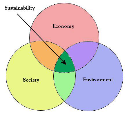
15
16 sustainability
17 Green Creek PUD: 40 townhomes, environmental education school, fire department pts. SITE/LOCATION LOCATION INFILL/REDEVELOPMENT: Infill (4), adjacent (2), and/or previously developed (1) TRANSIT: Over 50% of the development is within walking distance (1/4 mile) of transit stop (5). PROXIMITY TO EXISTING WATER/WASTEWATER: ties into existing (4); public extension (2) WILDLIFE/ECOLOGICAL COMMUNITIES: biological study with DOW compliance RIPARIAN/WETLAND PRESERVATION: 100' setback and water quality testing AGRICULTURAL LAND PRESERVATION: Doesn't remove historic/potential agricultural land EXISTING VEGETATION PRESERVATION: <10% existing tree/shrubs impacted (1) or no impact (2) BROWNFIELD/BLIGHT REDEVELOPMENT: Improves blighted lot (2), contamination cleanup (3) 2 2 STEEP SLOPES/RIDGELINES: on slopes less than 20% STORMWATER MANAGEMENT: 100% of surface drainage through bioswale/vegetated system.
18 CONNECTIONS AND USES 2 2 OPEN COMMUNITY: no gates, amenities are open to the public 0 4 PUBLIC ACCESS: provides appropriate public access to public lands/rivers (with agency approval) 4 pts. 0 4 COMPACT DEVELOPMENT: 7 or more units/acre; commercial >.50 FAR REDUCED FOOTPRINT: on previously disturbed area (1); all structures and parking <.50 lot (1) 2 2 CLUSTERING: efficient infrastructure, development concentrated in node(s), allowing for open areas OPEN SPACE: conservation easement meets components of open space criteria. See regulations REDUCED PARKING FOOTPRINT: less surface parking (2-3), carpool (1), covered bike storage (1-2) PARKING LOCATION: surface parking to rear of structures only (4); to side and screened (2) REDUCED PARKING: Does not exceed LURs: 1 pt. Study shows reduced on-site demand (2-3 pts.) 4 4 JOBS/HOUSING RATIO onsite housing for mixed-use non-residential (see regulations) 3 3 SCHOOL PROXIMITY: within a mile of a public school DIVERSITY OF USES: 1 point each use category listed in regulations DIVERSITY OF HOUSING TYPES 1 point each housing type listed in regulations above AFFORDABLE HOUSING 1 point each affordable housing unit provided above housing guidelines AFFORDABLE RENTAL HOUSING: Onsite rental housing, see regulations.
19 TRANSPORTATION WALKABLE STREETS: see commentary note: 16 pts. Not applicable STREET NETWORK: grid small block pattern, 2 pts, pedestrian connection at cul de sacs (1) TRANSIT FACILITIES: transit stop provided by development (2 pts.), covered bike storage (1 add'l pt.) WALKABLE VICINITY: score 10-25=1pt, 26-50=2pts, 51-75=3pts, =4pts. 3 3 BICYCLE NETWORK: Connection to community center via bicycle paths/routes. 2 2 ACCESS TO PUBLIC SPACES: 90% of units within 1/4 mile of public green space ACCESS TO ACTIVE SPACE: within 1/2 mile of ball field, 3-mile recreation trail, and/or dog park LOCAL FOOD PRODUCTION: private garden areas (1); community garden(s) (2); local market (1)
20 REQUIRED REQUIRED 0 X RESOURCE EFFICIENCY LIMITED TURF/SPECIES: <25% landscaped areas turf (1). Turf uses 25% less water than KBG (1). DIVERSE NATIVE LANDSCAPE: Landscape plan utilizes 10 or more local native low-water species. XERISCAPE: Landscape plan incorporates seven xeric design principles (see regulations) SOLAR ORIENTATION: 75% of all buildings have solar orientation (see regulations) RENEWABLE ENERGY 3 points for every 5% total energy offset by onsite renewable system(s). INFRASTRUCTURE RECYCLED CONTENT: Concrete/asphalt 75% or more recycled content. RECYCLING: Design includes areas for recycling co-mingled, paper, and cardboard. LIGHT POLLUTION: Exterior lighting minimized, shielded, night sky compliant. INNOVATION IN DESIGN: TOTAL 140+ EXCEEDS MINIMUM STANDARDS MEETS MINIMUM STANDARDS 0-69 DOES NOT MEET MINIMUM STANDARDS
21 Staff recommendations DOW compliance for wildlife migration/habitat Increase stream setback/wetland impacts Improve drainage plan to incorporate natural drainage/bioswale design. Provide public trailhead access. Reduce overall footprint Open space through conservation easement Demonstrate specific clustering strategies Reduce Parking Footprint Provide variety of housing types and possibly commercial uses at frontage Provide onsite inclusionary affordable housing beyond guidelines Incorporate playground/court/area within development Design pedestrian trail connecting clustered nodes within the development with the town. Incorporate xeric landscape design Solar Orientation= <75% of buildings are oriented to maximize solar orientation. Renewable Energy=Estimated ~30KW solar system proposed, provide additional onsite renewable energy. Inclusion of above items would increase score to 136 points

22 East End Case Study
23 East End: Pro-rated adjustment: Project came in at 103. Staff recommendations: Better location/screening for parking (2-4 points) Renewable Energy system(s) integrated (3-30 points) Private or Community garden area(s) (1 to 3 points) Covered bicycle parking (2 points) Diverse native landscape/xeriscape (1 to 3 points) Inclusion of above items could increase SCI to 145.
24 Pro-rated adjustment: 5-unit PUD: 78 Not Applicable points 88+ EXCEEDS MINIMUM STANDARDS MEETS MINIMUM STANDARDS 0-43 DOES NOT MEET MINIMUM STANDARDS
25 You cannot rate greatness on a graph! Rip it out! Pritchard Scale

26 Pritchard Scale You cannot rate greatness on a graph! Rip it out! Word

27 "You never change things by fighting the existing reality. To change something, build a new model that makes the existing model obsolete." -Buckminster Fuller


28
Kelowna Sustainability Checklist
 Kelowna Sustainability Checklist The City of Kelowna endeavours to Sustain the Environment. Encourage development and land use changes that will not compromise the ability of future generations to meet
Using AutoCAD Civil 3D and ESRI ArcGIS to meet LEED-ND (Neighborhood Development) Requirements NDIA O Brien & Gere. All Rights Reserved.
 Requirements NDIA O Brien & Gere. All Rights Reserved.") Using AutoCAD Civil 3D and ESRI ArcGIS to meet LEED-ND (Neighborhood Development) Requirements NDIA 12457 1 Using AutoCAD Civil 3D and ESRI ArcGIS to meet LEED-ND (Neighborhood Development) Requirements
Using AutoCAD Civil 3D and ESRI ArcGIS to meet LEED-ND (Neighborhood Development) Requirements NDIA 12457 1 Using AutoCAD Civil 3D and ESRI ArcGIS to meet LEED-ND (Neighborhood Development) Requirements
Municipal Plan*Assessment
 Municipal Plan*Assessment This tool was developed to assist in reviewing municipal master plans and in determining if these plans are consistent with smart growth principles, neighboring municipal plans,
Community Design Guidelines. Port Wallace DRAFT
 Community Design Guidelines Port Wallace DRAFT Energy 1 2 3 Nature Movement Connections Built Form DRAFT Layout Energy 1 Nature Community Design Guidelines GREAT COMMUNITIES PROTECT, CELEBRATE, AND CONSERVE
Gold Line Bus Rapid Transit Transit Oriented Development (BRTOD) Helmo Station Area Plan
 Helmo Station Area Plan") Appendix F Gold Line Bus Rapid Transit Transit Oriented Development (BRTOD) Helmo Station Area Plan Introduction and Purpose of the Plan The Gold Line Bus Rapid Transit facility is an eleven-mile dedicated
Appendix F Gold Line Bus Rapid Transit Transit Oriented Development (BRTOD) Helmo Station Area Plan Introduction and Purpose of the Plan The Gold Line Bus Rapid Transit facility is an eleven-mile dedicated
City of Langford Green Development Checklist
 City of Langford Green Development Checklist The following Green Development Checklist creates a sustainability standard for all comprehensive development within the City of Langford. The commitments made
What s in a Name Sustainability, Smart Growth, New Urbanism
 What s in a Name Sustainability, Smart Growth, New Urbanism Published in the Summer 2011 Issue of APA s The Commissioner Pete Pointner FAICP Planning commissioners frequently hear abstract terms bantered
Smart Growth Development Checklist
 2004 Smart Growth Development Checklist Smart Growth Development Checklist Corporation of the City of New Westminster Guide and manage growth in a manner which is consistent with the principles of sustainable
Tennessee Stormwater Management Program. Stormwater Management Site Assessment and Inventory Checklist. Quick Check o Vicinity Map within Watershed
 Tennessee Stormwater Management Program Project Name: Location: File Number: Reviewer: Date of Submittal: Review Date: Project Meeting Chronology: Type of Meeting: Date: Stormwater Management Site Assessment
THE POLICY FRAMEWORK FOR WALKABLE COMMUNITIES. Community Technical Assistance Program Building Active Communities Institute March 2016
 THE POLICY FRAMEWORK FOR WALKABLE COMMUNITIES Community Technical Assistance Program Building Active Communities Institute March 2016 ACTIVE COMMUNITIES BACK THEN ACTIVE COMMUNITIES BACK THEN Lifestyle
BOROUGH OF HADDONFIELD GREEN DEVELOPMENT PRACTICES CHECKLIST November 15, 2013
 BOROUGH OF HADDONFIELD GREEN DEVELOPMENT PRACTICES CHECKLIST November 15, 2013 The following questions are intended to focus attention and elicit information on the use of various sustainable development
2040 LUP is a part of the Comprehensive Plan and carries the same legal authority. Economic Challenges
 1.1. Guiding Anchorage s Growth Where will new residents settle over the next two decades? Where will people work, shop, and play? Will there be enough room to grow? How will Anchorage look? Will growth
CITY OF SACRAMENTO GENERAL PLAN. UC Davis ESP 171 Urban and Regional Planning April 21, 2011
 CITY OF SACRAMENTO GENERAL PLAN UC Davis ESP 171 Urban and Regional Planning April 21, 2011 1 OUTLINE Background Growth and Change Placemaking Sustainability and Climate Change Economic Development 2 City
URBAN DESIGN BRIEF URBAN DESIGN BRIEF 721 FRANKLIN BLVD, CAMBRIDGE August 2018
 URBAN DESIGN BRIEF URBAN DESIGN BRIEF 721 FRANKLIN BLVD, CAMBRIDGE August 2018 DESIGN BRIEF CONTENTS PART A 1.0 INTRODUCTION 2.0 DESCRIPTION & ANALYSIS OF SITE CONTEXT 3.0 DESIGN CONSTRAINTS AND OPPORTUNITIES
FORMER CANADIAN FORCES BASE (CFB) ROCKCLIFFE SECONDARY PLAN. Official Plan Amendment XX to the Official Plan for the City of Ottawa
 ROCKCLIFFE SECONDARY PLAN. Official Plan Amendment XX to the Official Plan for the City of Ottawa") FORMER CANADIAN FORCES BASE (CFB) ROCKCLIFFE SECONDARY PLAN Official Plan Amendment XX to the Official Plan for the City of Ottawa 1 INDEX THE STATEMENT OF COMPONENTS PART A THE PREAMBLE PAGE Purpose...
FORMER CANADIAN FORCES BASE (CFB) ROCKCLIFFE SECONDARY PLAN Official Plan Amendment XX to the Official Plan for the City of Ottawa 1 INDEX THE STATEMENT OF COMPONENTS PART A THE PREAMBLE PAGE Purpose...
Planned Development Review Revisions (Project No. PLNPCM )
") Planned Development Review Revisions (Project No. PLNPCM2014-00139) Standard residential development Planned Development Example: Smaller lot sizes than what is allowed to create open space amenity. What
Planned Development Review Revisions (Project No. PLNPCM2014-00139) Standard residential development Planned Development Example: Smaller lot sizes than what is allowed to create open space amenity. What
New Partners for Smart Growth Conference February 5, 2010
 Dan Stroh, Planning Director City of Bellevue Planning and Community Development Bellevue, WA New Partners for Smart Growth Conference February 5, 2010 Summary of Project Long-range plan update for Bel-Red
ARTICLE 6: Special and Planned Development Districts
 ARTICLE 6: Special and Planned Development Districts 6-10 Traditional Neighborhood Development (TND) District 6-10.10 Purpose and Intent The Traditional Neighborhood Development (TND) District provides
Route 347. New York State Department of Transportation Region 10, Long Island. THE GREENING of ROUTE 347
 The GREENING of Route 347 The Greening of Route 347 The Greening of Route 347: History 3 The Greening of Route 347 4 The Greening of Route 347 5 The Greening of Route 347 Smith Haven Mall 6 The Greening
Applicant Name Phone / Fax / Address City State Zip Code . Property Owner Phone / Fax / Address City State Zip Code
 Master Development Plan Application Community Development Department City of Redmond 411 SW 9 th Street Redmond, Oregon 97756 541-923-7721 541-548-0706 FAX Master Development Plan Fee $38,862.52 File Number
BROOKHILL NEIGHBORHOOD MODEL ZONING MAP AMENDMENT PREFACE TO APPLICATION
 BROOKHILL NEIGHBORHOOD MODEL ZONING MAP AMENDMENT PREFACE TO APPLICATION June 15, 2015 Revised: August 1, 2016 I. VISION Brookhill is a proposed community based upon the principles of Albemarle County
D-O LRT Zoning Discussion. Chapel Hill Boards & Commissions October 16, 2017
 D-O LRT Zoning Discussion Chapel Hill Boards & Commissions October 16, 2017 Update on Overall D-O LRT Station Area Initiative Objectives Design and educate on principles of Good Transit-Oriented Development
BRISTOL PLACE MASTER PLAN. Prepared for the City of Champaign
 BRISTOL PLACE MASTER PLAN Prepared for the City of Champaign TABLE of CONTENTS 4 Bristol Place Master Plan Introduction 5 Current Aerial 6 Master Plan 9 Building Types 10 Dimensional Plan 11 LEED-ND Scorecard
O Dell Parkway PUD Association, Inc. PO Box 1335
 CITY OF SOUTH BURLINGTON DEVELOPMENT REVIEW BOARD SD_14_06_F+MDevelopment_25BaconSt_sketch SKETCH PLAN REVIEW #SD-14-06 O DELL PARKWAY PUD DEPARTMENT OF PLANNING & ZONING Report preparation date: April
2. Would the proposed project comply with the Land Use map? 3. Would the proposed project require a rezoning? 4. What is the proposed zoning district?
 TOWN OF CHAPEL HILL Planning and Sustainability Department 405 Martin Luther King Jr. Blvd. Chapel Hill, NC 27514 www.townofchapelhill.org phone (919) 968 2728 Concept Plans are intended to be an opportunity
The Five Components of the McLoughlin Area Plan
 The Five Components of the McLoughlin Area Plan This documents contains the complete language of the five components of the McLoughlin Area Plan: The Vision Statement The Values The Guiding Principles
Section 9 NEIGHBORHOOD DESIGN
 Section 9 NEIGHBORHOOD DESIGN City of Lancaster Comprehensive Plan D u n k i n, S e f k o & A s s o c i a t e s, I n c. NEIGHBORHOOD DESIGN INTRODUCTION There are many ways in which a neighborhood can
Future Land Use SAMPLE RECOMMENDATIONS
 SAMPLE RECOMMENDATIONS Future Land Use The Future Land Use Chapter of the Master Plan builds upon prior chapters examining the existing conditions in their respective topic areas to present a comprehensive
3. VISION AND GOALS. Vision Statement. Goals, Objectives and Policies
 Vision Statement Queen Creek s interconnected network of parks, trails, open spaces and recreation opportunities provide safe and diverse activities and programs that sustain its unique, small town, equestrian
CITY PLANNING COMMISSION AGENDA ITEM: C STAFF: ROBERT TEGLER FILE NO: CPC PUD QUASI-JUDICIAL
 CPC AGENDA June 8, 2006 Page 37 CITY PLANNING COMMISSION AGENDA ITEM: C STAFF: ROBERT TEGLER FILE NO: CPC PUD 05-294 - QUASI-JUDICIAL PROJECT: APPLICANT: OWNER: PARKWOOD AT WOLF RANCH NASS DESIGN ASSOCIATES
Urban Design and Livability
 Urban Design and Livability City of Sacramento Planning Academy April 6, 2015 Bruce Monighan AIA Urban Design Manager, City of Sacramento How do we define cities in their characteristics of livability?
City of Redmond. Urban Holding Area Master Planning Requirements and Approval Process
 City of Redmond Urban Holding Area Master Planning Requirements and Approval Process June 21, 2006 City of Redmond: Urban Holding Area Master Planning Requirements and Approval Process Table of Contents
A larger version of this map is located on the last page of this PDF.
 MAP Committee Input McLoughlin Area Draft Vision Map A larger version of this map is located on the last page of this PDF. 1. The map above is intended to portray a vision for the McLoughlin area. It highlights
Municipal Development Plan Update Urban Service Area and Hamlets
 ENCLOSURE 1 Municipal Development Plan Update Urban Service Area and Hamlets Priorities Committee January 24, 2017 MUNICIPAL DEVELOPMENT PLAN UPDATE SHAPING OUR FUTURE MDP Update - Agenda MDP Update Public
S A C R A M E N T O C O U N T Y JACKSON HIGHWAY & GRANT LINE EAST VISIONING STUDY
 JACKSON HIGHWAY & GRANT LINE EAST S A C R A M E N T O C O U N T Y P L A N N I N G D E P A R T M E N T SUMMARY AND WORKBOOK November 19, 2008 History of the Visioning Study Sacramento County has two growth
Complete Neighbourhood Guidelines Review Tool
 Complete Neighbourhood Guidelines Review Tool Prepared By: City of Regina Planning Department October 2014 Page 1 of 14 Community Development Review Checklist for Secondary Plans and Concept Plans The
LEED for Neighborhood Development. A Brief Overview
 LEED for Neighborhood Development A Brief Overview What is LEED ND? LEED for Neighborhood Development First national standard for neighborhood design Developed as a partnership U.S. Green Building Council
FUTURE LAND USE ELEMENT
 FUTURE LAND USE ELEMENT GOAL I: To create and sustain a great place to live, play, and prosper Objective 1: The City of Ocala shall incorporate the principles and strategies of the Ocala 2035 Vision into
Transit Oriented Development. Overview
 Trammell Crow Residential Sean G. Hyatt, Managing Director Transit Oriented Development What is TOD? TOD in King County TOD Characteristics and Examples Veloce (Alexan Redmond TOD) About Trammell Crow
Appendix C: Interim Mixed-Use Evaluation Criteria
 Appendix C: Interim Mixed-Use Evaluation Criteria C-1 Appendix C: Interim Mixed-Use Evaluation Criteria PURPOSE: The implementation of numerous policies contained within the Master Plan hinges on the creation
LEED-ND 101: Practical Strategies for Achieving Sustainability Goals. Travis Parker Lakewood Planning Director
 LEED-ND 101: Practical Strategies for Achieving Sustainability Goals Travis Parker Lakewood Planning Director Metro Vision Idea Exchange Oct 11, 2012 West Corridor Stations West Corridor Overview West
Green Infrastructure Policies and Ordinances
 Green Infrastructure Policies and Ordinances October 23, 2013 By Karen Firehock, Green Infrastructure Center 2013 Georgia Urban Forest Council s 23 rd Annual Conference The mission of the nonprofit Green
Why and How to Evaluate the Feasibility of Infiltrating or Harvesting and Using Stormwater. Laura Prickett, EOA, Inc.
 Why and How to Evaluate the Feasibility of Infiltrating or Harvesting and Using Stormwater Laura Prickett, EOA, Inc. November 17, 2011 Outline of Presentation Why prioritize infiltration and harvest/use
Dwelling Units Max 12 dwelling units per acre/min 8 dwelling units per acre. Development Mix 80% non residential/20% residential
 13. OSTEEN LOCAL PLAN Background: The Osteen Local Plan area is located in southwest Volusia County along the SR 415 corridor between Lemon Bluff Road and Acorn Lake Road and includes 3,990 acres. The
Mitchell Ranch South MPUD Application for Master Planned Unit Development Approval Project Narrative. Introduction
 Mitchell Ranch South MPUD Application for Master Planned Unit Development Approval Project Narrative Introduction Mitchell Ranch South is a proposed single family (detached) residential development on
ICLEI Webinar Sustainability in the Master Plan and Zoning Code
 ICLEI Webinar Sustainability in the Master Plan and Zoning Code Sustainability in Grand Rapids 2000 2002 New Master Plan 2004 2005 Neighborhood Pattern Workbook 2006 2007 Form-Based Zoning Ordinance 2007
CHAPTER 4 FUTURE LAND USE AND URBAN SERVICES DISTRICTS
 CHAPTER 4 FUTURE LAND USE AND URBAN SERVICES DISTRICTS Introduction This chapter discusses how Benzie County should grow and change in the future. A community can grow and change in many different ways.
F. The following uses in the HR District: attached single-family dwellings, condominiums, and institutional uses; and
 1102 DESIGN REVIEW 1102.01 PURPOSE AND APPLICABILITY Section 1102 is adopted to provide standards, criteria, and procedures under which design review may be approved. Design review is required for: A.
Subarea 4 Indian Creek. Vision The combination of park networks and transportation amenities make Subarea 4 the greenest hub in the Corridor.
 indian creek 180 extends south from 101st Street to I-435. The I-435 and Metcalf intersection is one of the primary intersections in the Kansas City Metro Area. The area includes several residential neighborhoods
The West Vaughan Employment Area Secondary Plan Policies
 Part 2: The West Vaughan Employment Area Secondary Plan Policies 2.1 General Policies It is the policy of Council: 2.1.1. That the West Vaughan Employment Area (the WVEA), identified on Schedule 1, will
Glenborough at Easton Land Use Master Plan
 Vision Statement Sunrise Blvd. Hazel Ave. Prairie City Rd. Gencorp Property Lincoln Regional Airport 1.0 VISION STATEMENT The identifies City of the principles, goals, policies, and standards Lincoln that
11 GUIDING PRINCIPLES:
 11 GUIDING PRINCIPLES: CATEGORIES FIVE GUIDING PRINCIPLE CATEGORIES The Policy Statement will contain a set of Guiding Principles to inform the urban design and sustainability objectives for the site.
3.9 Systems Interrelationships
 191 Sustainability Building Blocks: The Comprehensive Plan Systems Community Form Economy Social Transportation Natural Resources Housing and Neighborhoods Utilities and Infrastructure Institutions.9 Systems
for Master Planned Development Framework Design Standards & Guidelines
 B L A C K D I A M O N D DE S I G N G U I D E L I N E S for Master Planned Development Framework Design Standards & Adopted June 18, 2009 Introduction and Purpose The Master Planned Development (MPD) Framework
AWH REPORT OF THE PLANNING AND DEVELOPMENT DEPARTMENT FOR APPLICATION FOR REZONING ORDINANCE TO PLANNED UNIT DEVELOPMENT
 AWH REPORT OF THE PLANNING AND DEVELOPMENT DEPARTMENT FOR APPLICATION FOR REZONING ORDINANCE TO PLANNED UNIT DEVELOPMENT MAY 8, 2014 The Planning and Development Department hereby forwards to the Planning
Living in Albemarle County s Urban Places
 Living in Albemarle County s Urban Places ALBEMARLE COUNTY, VIRGINIA A Closer Look at Albemarle s Approach to Managing Growth and Creating Quality Urban Environments www.albemarle.org Page 2 Living in
1. Parks & Recreation Neighborhood Parks Community Parks Special Use Sites 2. Open Space 3. Trails
 Appendix A: Park Classifications The intent of parks and recreation classifications is to aid in making acquisition and design decisions for park sites, facilities and the organization of recreation space
Rural Land Use Designations Kittitas County December 6, 2007 Draft
 KITTITAS COUNTY COMMUNITY DEVELOPMENT SERVICES 411 N. Ruby St., Suite 2, Ellensburg, WA 98926 CDS@CO.KITTITAS.WA.US Office (509) 962-7506 Fax (509) 962-7682 Rural Land Use Designations Kittitas County
Subregion 4 Central Avenue-Metro Blue Line Corridor Transit-Oriented Development (TOD) Implementation Project. Community Meeting April 27, 2011
 Implementation Project. Community Meeting April 27, 2011") Subregion 4 Central Avenue-Metro Blue Line Corridor Transit-Oriented Development (TOD) Implementation Project Community Meeting April 27, 2011 Overview Introduction to Subregion 4 TOD Implementation Program
Subregion 4 Central Avenue-Metro Blue Line Corridor Transit-Oriented Development (TOD) Implementation Project Community Meeting April 27, 2011 Overview Introduction to Subregion 4 TOD Implementation Program
Urban Sustainability Strategies in the US: An Examination into the LEED - Neighborhood Development Program
 Urban Sustainability Strategies in the US: An Examination into the LEED - Neighborhood Development Program Russell M. Smith, Ph.D. Associate Professor of Geography Winston-Salem State University August
March 21, 2018 ALCA Meeting. March 21, 2018
 March 21, 2018 ALCA Meeting March 21, 2018 Agenda 1. Process and Timeline 2. Original Submission 3. Revised Submission 4. Next Steps The City of Calgary Role: The City is responsible for capturing and
CHAPTER 2: PLANNING PRINCIPLES
 CHAPTER 2: PLANNING PRINCIPLES 2 Comprehensive Principles The following overarching Principles provide the basis for the goals and policies included in the Mendocino County General Plan. These Principles
North Oakville East Parks Facilities Distribution Plan. November, 2009
 North Oakville East November, 2009 POLICY CONTEXT 1) Purpose a) The purpose of this document is to be a guide for the location, configuration, design and development of the parks system for the North Oakville
Whitemarsh Comprehensive Plan Update: Housing & Land Use. Public Workshop #3: September 20, 2018
 Whitemarsh Comprehensive Plan Update: Housing & Land Use Public Workshop #3: September 20, 2018 Agenda Welcome Process Recap What We ve Heard The Plan Framework Review of Recommended Actions Land Use Housing
Ten Mile Creek Planning Area
 PLANNING AREA POLICIES TEN MILE CREEK Ten Mile Creek Planning Area Location and Context The Ten Mile Creek Planning Area ( Ten Mile Creek area ) is located south of the current Boise AOCI, generally south
City of Woodinville Planning Commission Study Session. Development Regulations 101: An Overview of Specific Regulatory Items To Help You in 2012
 City of Woodinville Planning Commission Study Session Development Regulations 101: An Overview of Specific Regulatory Items To Help You in 2012 Development Regulations 101 Overview of the Different Zones
GUIDELINES. Transit Oriented Development. Approved by Edmonton City Council on February 15, 2012 in tandem with City Policy C565
 Transit Oriented Development GUIDELINES Prepared by the City of Edmonton Sustainable Development and Transportation Services Departments Approved by Edmonton City Council on February 15, 2012 in tandem
City of St. Thomas New Official Plan
 City of St. Thomas New Official Plan Sustainable & Healthy Community Workshop Ann Joyner and Paddy Kennedy Dillon Consulting Limited Work Shop Outline Introduction Presentation Exercise 1 (individual)
Official Plan Review
 Official Plan Review Summary Report - The Built Environment August 2014 Part 1: Introduction Planning for a healthy, prosperous and sustainable community is an important goal for our municipality. From
Plano Tomorrow Vision and Policies
 Plano Tomorrow Vision and Policies PLANO TOMORROW PILLARS The Built Environment The Social Environment The Natural Environment The Economic Environment Land Use and Urban Design Transportation Housing
CHAPTER 6: Community Design and Appearance
 AGLE AREA COMMUNITY Plan CHAPTER 6 CHAPTER 6: Community Design and Appearance Community Design and Appearance How a community is designed and what a community looks like are attributes fundamental to the
OVERVIEW OF PLANS FOR THE JEFFERSON COUNTY COUNTRYSIDE FARM In the Context of Quality Place Characteristics
 OVERVIEW OF PLANS FOR THE JEFFERSON COUNTY COUNTRYSIDE FARM In the Context of Quality Place Characteristics By Steve Grabow, Professor and Community Development Educator University of Wisconsin-Extension,
2. Would the proposed project comply with the Land Use map? 3. Would the proposed project require a rezoning? 4. What is the proposed zoning district?
 TOWN OF CHAPEL HILL Planning and Sustainability Department 405 Martin Luther King Jr. Blvd. Chapel Hill, NC 27514 www.townofchapelhill.org phone (919) 9682728 Concept Plans are intended to be an opportunity
Planning & Development. Background. Subject Lands
 Planning & Development APPLICATION BRIEFING Prepared For: Planning Advisory Committee Submitted by: Jason Fox, Director of Planning & Development Date: Subject: Development Agreement Application by Brentwood
APPENDIX A - Block and Draft Plan
 Built Environment - Compact Development B&D 1 Persons & Jobs per hectare Note: Each municipality defines density ranges by land use types within the Official Plan and the Secondary Plans Places to Grow
Land Use & Transportation Primer
 Land Use & Transportation Primer Presented By Smitha Vijayan Center for Urban Transportation Studies University of Wisconsin-Milwaukee Role of Local Government Land use decision-making power mostly given
Implementation Guide Comprehensive Plan City of Allen
 Implementation Guide 2030 Comprehensive Plan City of Allen DRAFT 2015 Implementation Guide Allen 2030 Comprehensive Plan INTRODUCTION The Comprehensive Plan serves as a guide for the growth and development
NEWPORT NEWS/WILLIAMSBURG INTERNATIONAL AIRPORT DESIGN AND SUSTAINABILTY GUIDELINES
 NEWPORT NEWS/WILLIAMSBURG INTERNATIONAL AIRPORT DESIGN AND SUSTAINABILTY GUIDELINES VERSION 1.6 August 2011 PREPARED BY: 900 Bland Boulevard Suite G Newport News, Virginia 23602 DESIGN AND SUSTAINABILITY
Concord Community Reuse Project Goals and Guiding Principles. Overarching Goals (OG)
") Concord Community Reuse Project Goals and Guiding Principles Overarching Goals (OG) No priority is implied by the order of presentation of the goals and guiding principles. Overarching goals for the Concord
Concord Community Reuse Project Goals and Guiding Principles Overarching Goals (OG) No priority is implied by the order of presentation of the goals and guiding principles. Overarching goals for the Concord
Asbury Chapel Subdivision Sketch Plan
 Asbury Chapel Subdivision Sketch Plan PART 1: PROJECT SUMMARY Applicant: NVR Inc. Project Size: +/- 76.13 acres Parcel Numbers: 02101112,02116101,02116112, 02116113 Current Zoning: Transitional Residential
Improve Neighborhood Design and Reduce Non Point Source Water Pollution
 HOW TO Planning Guide Improve Neighborhood Design and Reduce Non Point Source Water Pollution This document was funded by a grant from the New Hampshire Coastal Program with funding from the National Oceanic
Chapter 10 IMPLEMENTATION RECOMMENDATIONS
 Chapter 10 IMPLEMENTATION RECOMMENDATIONS The recommended land use plan presented in the previous chapter provides a design for the attainment of the urban and rural development and open space preservation
Town of Peru Comprehensive Plan Executive Summary
 Town of Peru Comprehensive Plan Executive Communities that plan grow by choice, not by chance. A plan makes growth thoughtful, understandable, and predictable. A plan shows that a community is managing
CITY OF CLEVELAND GREEN DESIGN GUIDELINES
 CITY OF CLEVELAND GREEN DESIGN GUIDELINES SEPTEMBER 18, 2008 PROJECT COMPLIANCE PATH: 1. Approved master plan 2. Approved design district boundaries 3. Approved district design guidelines, Green design
Zoning Technical Review Presented by Camiros. November 10, 2015
 Zoning Technical Review Presented by Camiros November 10, 2015 TECHNICAL REVIEW OVERVIEW Purpose of this Report Outline issues with current Ordinance Present preliminary approaches for revisions Set drafting
Nanaimo OCP Community Consultation
 Nanaimo OCP Community Consultation November 18, 2006 Cheeying Ho, Smart Growth BC Outline Problems with conventional development patterns Smart growth principles Plan Nanaimo 5 goals Progress and areas
3 Vision and Goals. Vision and Goals. Blueprint for Bloomsburg. Vision. Town of Bloomsburg Comprehensive Plan,
 Vision and Goals 3 Vision and Goals Citizens of the Town of Bloomsburg clearly value their natural and cultural heritage, the walkable, mixed use pattern of downtown, the access to education, and the community
RESPONSES TO PUBLIC CONCERNS AND QUESTIONS
 RESPONSES TO PUBLIC CONCERNS AND QUESTIONS Stations and Summary Questions for Public Meeting #2 June 23, 2015 General Questions / Concerns: 1. Is there any way this development can raise revenue for the
LAND USE ELEMENT. Purpose. General Goals & Policies
 LAND USE ELEMENT Purpose This Land Use Element contains the goals and policies necessary to support the City s responsibility for managing land resources and guiding development through implementing regulations,
Urban Stormwater: Best Practice Environmental Management Guidelines. CSIRO This electronic edition published by CSIRO PUBLISHING, 2006.
 Urban Stormwater: Best Practice Environmental Management Guidelines. Chapter 5 Water Sensitive Urban Design Key references Department of Planning, 1993, Better Drainage: Guidelines for the Multiple Use
CONTENTS 8.0 LAND USE 8.1 GENERAL LAND USE 8.2 RESIDENTIAL 8.3 MIXED USE 8.4 COMMERCIAL 8.5 EMPLOYMENT LANDS
 8-2 Land Use 8.0 LAND USE CONTENTS 8.1 GENERAL LAND USE 8.1.1 Uses provided for in all Land Use Designations 8.1.2 Uses prohibited in Hazardous Lands, Hazardous Sites and Special Policy Areas 8.1.3 Uses
2.7 ac park. TOTAL 5,403 DU 1,297,900 sf 1,105,450 sf 3.87 ac 5,563 DU 1,121,200 sf 1,105,450 sf 3.87 ac
 PLAN AMENDMENT 2013-I-B1: SEVEN CORNERS SPECIAL STUDY Summary of Pre-staffing Comments Planner: Bernard Suchicital bsuchi@fairfaxcounty.gov (703) 324-1254 Background On October 29, 2013, the Board of Supervisors
THE 355/270 CORRIDOR:
 THE 355/270 CORRIDOR: Strategic Ideas for Sustaining a Livable Work Place Project Summary ACCESS LIFE DESIGN HEALTH WORK Montgomery County Planning Department The Maryland-National Capital Park and Planning
Preliminary Recommendations Tk Takoma/Langley Crossroads Sector Plan
 Preliminary Recommendations Tk Takoma/Langley Crossroads Sector Plan Vision is to achieve a Transit Oriented, pedestrian friendly Community that Celebrates and builds upon the cultural Diversity of the
5. Would the proposed project require modifications to the existing regulations?
 TOWN OF CHAPEL HILL Planning and Sustainability Department 405 Martin Luther King Jr. Blvd. Chapel Hill, NC 27514 www.townofchapelhill.org phone (919) 968-2728 Concept Plans are intended to be an opportunity
RECREATION AND OPEN SPACE ELEMENT GOALS, OBJECTIVES, AND POLICIES
 RECREATION AND OPEN SPACE ELEMENT GOALS, OBJECTIVES, AND POLICIES Goal 7 To provide park facilities, recreation programs, and open space resources that are safe, adequate, and accessible to all City residents,
The Urban Design working group s vision for a sustainable Elgin includes the following:
 The Urban Design working group has focused on promoting an urban design framework for a sustainable Elgin that is more livable, more respectful of nature, more interconnective, more prosperous, more compact,
PLANNING JUSTIFICATION REPORT
 PLANNING JUSTIFICATION REPORT 55 DELHI STREET CITY OF GUELPH PREPARED FOR: VESTERRA PROPERTY MANAGEMENT PREPARED BY: LABRECHE PATTERSON & ASSOCIATES INC. SCOTT PATTERSON, BA, CPT, MCIP, RPP PRINCIPAL,
Design for Health Comprehensive Plan Review Checklists. Design for Health,
 Comprehensive Plan Review Checklists, 2007 info@designforhealth.net These Comprehensive Plan Review Checklists summarize the key points of the (DFH) background and health impact assessment (HIA) materials.
Appendix 3-D LOCAL CODE AND ORDINANCE REVIEW AND EVALUATION
 Appendix 3-D LOCAL CODE AND ORDINANCE REVIEW AND EVALUATION Table of Contents Appendix Section Headings 3-D.1.0 INTRODUCTION 3-D-2 3-D.2.0 PREPARING TO COMPLETE A CODE AND ORDINANCE WORKSHEET 3-D-3 3-D.2.1