Initiative 123. Alaskan Way Elevated Park + other amenities. voteyeson123.org
|
|
|
- Ginger Dalton
- 5 years ago
- Views:
Transcription
1 Initiative 123 Alaskan Way Elevated Park + other amenities voteyeson123.org
2 SDOT has a plan for the downtown waterfront, but the plan doesn t create value, beauty or public benefit and it doesn t leverage our public assets. The billion dollar public view currently enjoyed from the viaduct is discarded in favor of a Tideline Promenade that is actually a supersized boardwalk located between a freight route arterial and touristy buildings on the piers. It s a noisy location with traffic cutting across the space and you can hardly see the water or the mountains. The space will be empty most of the year which will create a liability.

3 The SDOT plan moves the freight route arterial to the east side of the street and creates a super-sized boardwalk called Tideline Promenade. Note that service driveways cut through the promenade at every pier as does ferry loading and unloading at Colman Dock. SDOT s promenade is hemmed in by the touristy buildings on the piers and the busy, noisy freight route arterial on Alaskan Way.
4 The SDOT plan offers a huge viewing ramp connecting the market to Alaskan Way called Overlook Walk. Although it s compliant with A.D.A. requirements, it s repulsive to people with mobility impairments who much prefer level spaces with elevators. This space is also likely to be empty much of the year. The SDOT plan creates a no-man s land below the big ramp with a new train-bypass roadway called Elliott Way that is incomplete and inhumane and damages property values. This space will exacerbate the bad behaviors that are already a problem there.

5 The SDOT plan has an enormous body-breaking ramp from the market to Alaskan Way. The SDOT plan creates a nomans land below the ramp. The SDOT plan buries the existing condominiums on Alaskan Way up to the second floor with a truck ramp.
6 Initiative 123 fixes the flaws in the SDOT plan.
7 Initiative 123 establishes a Downtown Waterfront Preservation and Development Authority modeled after Pike Place Market Preservation and Development Authority with the purpose of revitalizing the downtown waterfront with a plan that preserves the public view currently enjoyed from the viaduct, balances the needs of the many interests in the Alaskan Way corridor and benefits the citizens of Seattle.
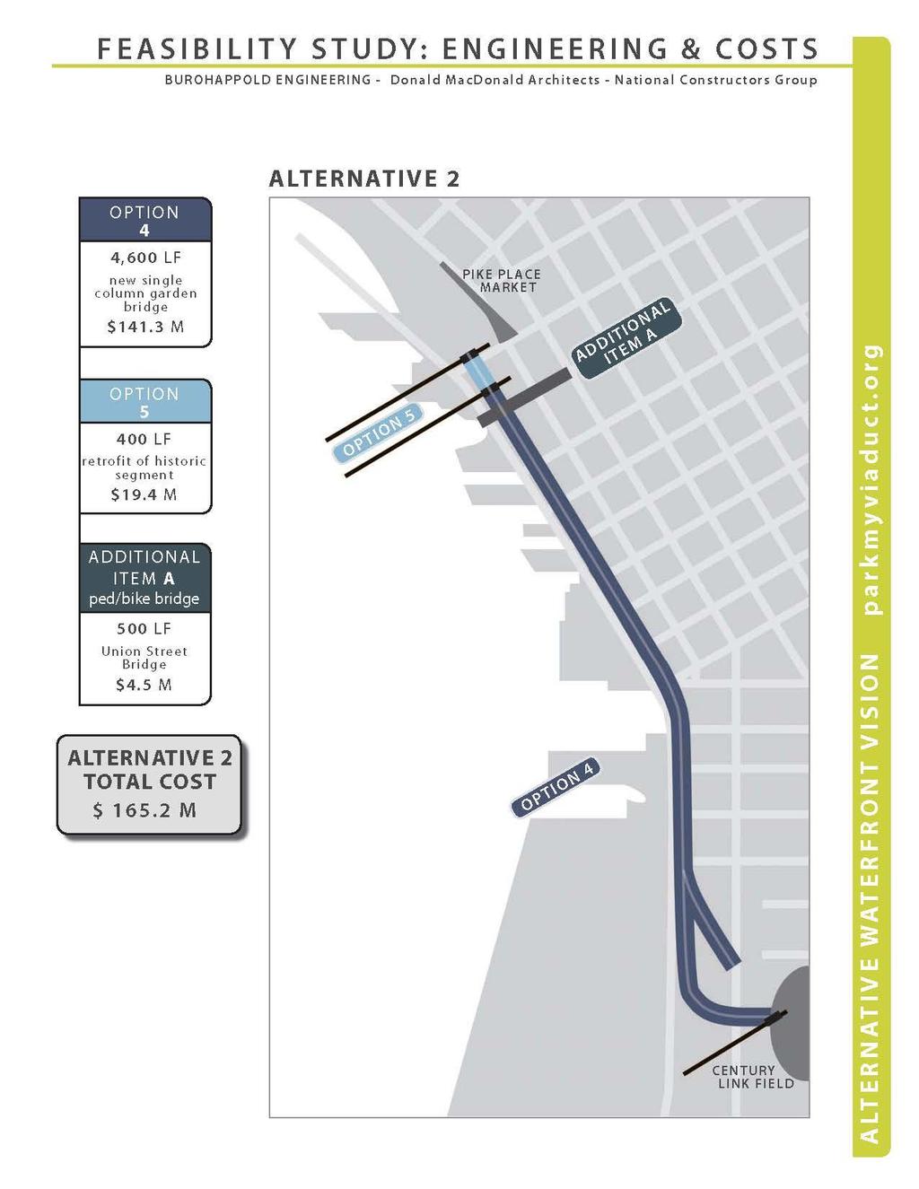
8 The signature feature of the Initiative 123 plan for the downtown waterfront is Alaskan Way Elevated Park which will be built on a brand new mile-long garden bridge after the tunnel is complete and the viaduct is removed. It will offer spectacular panoramic views from an inspirational, accessible, car-free park that extends from the market to CenturyLink Field and will create a legacy for Seattle s future. An iconic 400 section of the Alaskan Way Viaduct will be integrated into the garden bridge design.
9
10 Initiative 123 s plan for the downtown waterfront costs the same as the SDOT plan and is funded from the same sources. Making components the right size and putting them in the best locations allows us to get much more back from our investments without spending more. The supersized boardwalk of the SDOT plan (Tideline Promenade) becomes a right-sized sidewalk and the huge viewing ramp (Overlook Walk) is replaced with the level elevated park and the grand downtown access bridge from Union St.
11
12 Remember, it s not Alki down there at street level on Alaskan Way and neither marketing, nor renderings nor political donations will make it Alki.

13 This is the context of our downtown waterfront.


14 These are views from the boardwalk or commercial sidewalk along the buildings on the piers described as a Tideline Promenade in the SDOT plan.


15 And these are views from some world class promenades.

16 This is one of many spectacular views we ll see when we vote YES on 123 to put the promenade up where the view is.

17 Let s keep the legacy going of spectacular views for all to enjoy...
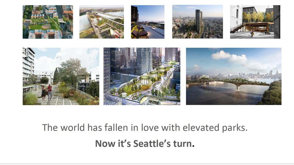
18

19 In the 90 s Paris repurposed an old elevated train route and made it a 3 mile park called Promenade Plantee.


20 Twenty years later, activists inspired by that park brought The High Line to NYC -- a 1.5 mile elevated park. They liked it so much they created a second one -- The High Bridge.

21 Chicago Philadelphia San Francisco Washington,DC Toronto London Seoul Helsinki Rotterdam Mexico City and more
22 Proponents of Initiative 123 have done their homework. Top-shelf urban infrastructure planners and engineers, BuroHappold, were brought in to conduct a Feasibility Study. Talmadge + Fitzpatrick were hired to do the legal work to develop the initiative. Over 30,000 signatures were collected and certified qualifying Initiative 123 for the August 2, 2016 ballot.

23 Ballots arrive in mid-july. Vote by August 2.
24 Initiative 123 Alaskan Way Elevated Park + other amenities voteyeson123.org
1.1 WATERFRONT SEATTLE
 1.1 WATERFRONT SEATTLE Over the past few years, the City of has been actively re-imagining the future of its Central Waterfront. The imminent replacement of the Elliott Bay Seawall and removal of the Alaskan
Alaskan Way, Promenade, and Overlook Walk Final EIS Appendix D - Supplemental Draft EIS Comments and Responses October 2016.
 B-001-001 The use of Columbia Street for two-way transit was a decision made by King County Metro as part of its Southwest Transit Pathway evaluation. This project is separate from AWPOW. B-001-002 Modeling
What s Up Next In The Seattle Squeeze. PSRC Transportation Policy Board April 11
 What s Up Next In The Seattle Squeeze PSRC Transportation Policy Board April 11 1 Current construction Alaskan Way Viaduct removal Removes the viaduct (including foundations and ramps) and restores the
Appendix G Public Services and Utilities Discipline Report. Draft Environmental Impact Statement Alaskan Way, Promenade, and Overlook Walk
 Appendix G Public Services and Utilities Discipline Report Draft Environmental Impact Statement Alaskan Way, Promenade, and Overlook Walk May 2015 Alaskan Way, Promenade, and Overlook Walk Draft Environmental
APPENDIX C Discipline Report Errata Sheets. Final Environmental Impact Statement Alaskan Way, Promenade, and Overlook Walk
 APPENDIX C Discipline Report Errata Sheets Final Environmental Impact Statement Alaskan Way, Promenade, and Overlook Walk October 2016 Alaskan Way, Promenade, and Overlook Walk Final Environmental Impact
Appendix H Historic Resources Discipline Report. Draft Environmental Impact Statement Alaskan Way, Promenade, and Overlook Walk
 Appendix H Historic Resources Discipline Report Draft Environmental Impact Statement Alaskan Way, Promenade, and Overlook Walk May 2015 Alaskan Way, Promenade, and Overlook Walk Draft Environmental Impact
Locally Preferred Alternative (LPA) Report (Volume I) Appendix A
 Report (Volume I) Appendix A") The Seattle Department of Transportation Seattle Center City Connector Transit Study Locally Preferred Alternative (LPA) Report (Volume I) Appendix A September 2014 in association with: URS Shiels Obletz
The Seattle Department of Transportation Seattle Center City Connector Transit Study Locally Preferred Alternative (LPA) Report (Volume I) Appendix A September 2014 in association with: URS Shiels Obletz
City of Poughkeepsie Waterfront Redevelopment Strategy. Poughkeepsie Waterfront Redevelopment Strategy
 City of Poughkeepsie Waterfront Redevelopment Strategy Poughkeepsie Waterfront Redevelopment Strategy City of Poughkeepsie Prime Assets: Major Waterfront Advantages: - Central City of the Hudson River
EXECUTIVE SUMMARY. Final Environmental Impact Statement Alaskan Way, Promenade, and Overlook Walk
 EXECUTIVE SUMMARY Final Environmental Impact Statement Alaskan Way, Promenade, and Overlook Walk October 2016 Final Environmental Impact Statement Executive Summary Alaskan Way, Promenade, and Overlook
Appendix K Vegetation and Wildlife Discipline Report. Draft Environmental Impact Statement Alaskan Way, Promenade, and Overlook Walk
 Appendix K Vegetation and Wildlife Discipline Report Draft Environmental Impact Statement Alaskan Way, Promenade, and Overlook Walk May 2015 Alaskan Way, Promenade, and Overlook Walk Draft Environmental
Lake Oswego to Portland Transit Project. Lessons Learned. John Cullerton Senior Project Manager, URS 2012 APTA/TRB Light Rail Conference
 Lake Oswego to Portland Transit Project Lessons Learned John Cullerton Senior Project Manager, URS 2012 APTA/TRB Light Rail Conference Overview Project Location and Context Corridor History and Project
PIKE PINE RENAISSANCE: ACT ONE. October 19, 2017
 PIKE PINE RENAISSANCE: ACT ONE October 19, 2017 WATERFRONT SEATTLE PROGRAM PROJECT INTRODUCTION Pike and Pine streets, between First and Melrose avenues Pedestrian and streetscape improvements Budget:
TOD 203 CORRIDOR PLANNING and TOD
 2 CORRIDOR PLANNING and Scales of What You Will Learn The Transit Corridor Types of Corridors Objectives and Strategies for Transit and at the Corridor Level Main Street Corridor Planning and Your Trainers
preliminary master plan Cover Slide executive summary public presentation
 preliminary master plan public presentation executive summary Cover Slide {agenda} + Master Plan Process + Context and Overviews + Preliminary Concepts - Entry/Gateways - Core District - Streetscape +
Bloor Street East Potential Ravine Portal Overlook and Access Passage to the Rosedale Valley and Don River Valley Ravine, Toronto, Canada
 TRANSFORMATIVE IDEA 2. GREAT STREETS Bloor Street Christie Pits Park Bloor St Spadina Ave Bathurst St Shaw St 1 Recognize the significant public realm improvements along Bloor Street and extend and enhance
Alaskan Way, Promenade, and Overlook Walk
 Draft Environmental Impact Statement Executive Summary Alaskan Way, Promenade, and Overlook Walk Prepared for Seattle Department of Transportation Seattle, Washington June 2015 Americans with Disabilities
Corridors. Re-vitalize our Corridors and Gateways
 Corridors Re-vitalize our Corridors and Gateways Artist s rendering from the 287 Strategic Plan, 2015 Corridors are the major throughways of Loveland but they also provide important commercial, community
CLIMATE CHANGE. DIALOGUE ON CITIES AND CLIMATE CHANGE World Bank Washington, September 21-23, 2009
 DIALOGUE ON CITIES AND CLIMATE CHANGE CLIMATE CHANGE CITIES IN ACTION World Bank Washington September 21-23, 2009 METROPOLIS Created in 1985, the association brings together major cities and metropolitan
Wasatch CHOICE for 2040
 Wasatch CHOICE for 2040 Economic Opportunities We Can Choose a Better Future We enjoy an unparalleled quality of life along the Wasatch Front. People from all over the world are drawn to our stunning scenery,
Jim Harkins DUNDEE WATER FRONT CIRCULATOR DUNDEE WATER FRONT CIRCULATOR. Specialists in Affordable & Sustainable Tramways. A short presentation by
 DUNDEE WATER FRONT CIRCULATOR DUNDEE WATER FRONT CIRCULATOR A short presentation by Jim Harkins Light Rail (UK) Specialists in Affordable & Sustainable Tramways www.lightrailuk.com E-mail Lightrailuk@aol.com
NEXT HOT NEW NEXT HOT
 NEWINTERIORS // ARCHITECTURE // FASHION // ART // DESIGN PACIFIC NORTHWEST DESIGN N O 31: DEC. 2016 / JAN. 2017 NEXT HOT NEW NEXT HOT THIS YEAR S ROUNDUP OF THE PEOPLE, PLACES, AND THINGS YOU NEED TO KNOW
Welcome. Community Consultation Meeting November 28, Review and discuss the Bathurst Quay Neighbourhood Plan Framework
 Welcome Community Consultation Meeting November 28, 2016 Why Are We Here Today? Review and discuss the Bathurst Quay Neighbourhood Plan Framework Review and discuss an Action Plan for Implementation Next
parklets tiny parks with big impacts for city streets SvR Design Sarah Gould 12/21/12
 parklets tiny parks with big impacts for city streets SvR Design Sarah Gould 12/21/12 Not surprisingly, the close connection between people s use of city space, the quality of city space and degree of
Bridgeport Comprehensive Waterfront Plan 2 nd Launch Neighborhood Meeting 3/9/16
 CivicMoxie 2016 #WaterfrontBPT @CivicMoxie Bridgeport Comprehensive Waterfront Plan 2 nd Launch Neighborhood Meeting 3/9/16 City of Bridgeport OPED, Department of Planning Bridgeport s greatest asset is
Port Lavaca Future Land Use
 Port Lavaca Future Land Use Introduction The City of Port Lavaca is beginning to see sustained growth, after many years of relative stable population. New single family homes, apartments, and businesses
Lower South Street/Louisa Street Charrette Final Presentation. September 22, 2009
 Lower South Street/Louisa Street Charrette Final Presentation September 22, 2009 Recap Mayor and Council called for a Charrette to engage the public on creating a vision for the Lower South Street area.
Previous Stakeholder Meetings
 Titusville Tomorrow Previous Stakeholder Meetings Workshop 1 SWOT CVS Workshop 2 SWOT and CVS Results Value of Place Based Design 3 Table Top Designs The Waterfront The Gateways The Downtown Key Points
Harlem Avenue Corridor Plan: Corridor Planning Across Municipal Boundaries
 Harlem Avenue Corridor Plan: Corridor Planning Across Municipal Boundaries Heather Tabbert, Manager, Local Planning and Programs Division Regional Transportation Authority (RTA) Jen McNeil Dhadwal, Principal
Denver Moves: Transit Task Force
 Insert transit picture Denver Moves: Transit Task Force Meeting #8 October 5, 2017 1. Welcome & Introductions Opening remarks and housekeeping Task Force and audience introductions Upcoming events and
Niagara National Heritage Area
 Niagara National Heritage Area What is a National Heritage Area? It is a regional place where natural, cultural, historic and recreational resources combine to form a nationally distinctive landscape and
Windsor Locks Transit-Oriented Development Planning Grant Request. Project Background
 Windsor Locks Transit-Oriented Development Planning Grant Request Project Background Downtown Windsor Locks runs along Main Street in the vicinity of the intersection of Routes 159 and 140. The current
MARINA MARKET & WATERFRONT DEVELOPMENT STUDY PORT ARANSAS, TEXAS
 MARINA MARKET & WATERFRONT DEVELOPMENT STUDY PORT ARANSAS, TEXAS FEBRUARY 2015 PRESENTATION OUTLINE 1 2 3 4 5 6 7 REGIONAL POSITIONING SITE IMPRESSIONS PLANNING & DESIGN PRINCIPLES EXISTING IMPROVEMENTS
Workshop #3 June 13, 2016
 Downtown Ocoee Master Plan Workshop #3 June 13, 2016 Our Team Our Team and Tonight s Goal Quick Recap: Why a Downtown Plan? How are we developing the plan? How can you still be involved? What s left to
From i-waterfront to i-canada. The Role of Intelligent Communities in Canada's Digital Opportunity
 From i-waterfront to i-canada The Role of Intelligent Communities in Canada's Digital Opportunity 2015 Hutchison Management International Inc. All Rights Reserved April 29, 2015 From Automation to Smart/Intelligent
Freeway Demolition and Economic Regeneration in San Francisco
 Freeway Demolition and Economic Regeneration in San Francisco TRANSform Scotland Is Transport Good for Your Wealth? April 22, 2002 Andrew Nash, P.E. Presentation Outline Loma Prieta Earthquake Embarcadero
Transportation Land Use Integration & Regional Planning. Don Kostelec, AICP Senior Planner, Louis Berger Group February 1, 2010
 Transportation Land Use Integration & Regional Planning Don Kostelec, AICP Senior Planner, Louis Berger Group February 1, 2010 Transportation Land Use Integration DOT-HUD-EPA Sustainable Communities Initiative
Ship Creek Redevelopment
 Ship Creek Redevelopment Three Concepts May 2013 Cambridge ARCHITECTURE Philadelphia ENGINEERING Raleigh INTERIORS San Francisco PLANNING Washington, DC www.klingstubbins.com contact@klingstubbins.com
THE STILLWATER BRIDGE STORY
 THE STILLWATER BRIDGE STORY 1931 Stillwater Bridge Part I: The Backstory Behind the Bridge Undoubtedly the highest profile road project in Minnesota is the new bridge at Stillwater, the St. Croix Crossing.
City of Plattsburgh DRI: Downtown Streetscapes & Riverfront Access. Downtown Streetscape and Riverfront Access Design
 City of Plattsburgh DRI: Downtown Streetscapes & Riverfront Access Welcome Thank you for coming this evening. Agenda PART I - Project Context The Downtown Revitalization Program Our DRI Projects Other
What if. We Built Hong Kong s Waterfront Around Places?
 What if We Built Hong Kong s Waterfront Around Places? 32 years of Placemaking 48 U.S. States, 6 Canadian Provinces 26 Countries 2000 Communities 2 Million visitors to our web sites (2006) 27,000 people
TOWN COUNCIL / PLANNING COMMISSION
 Workshop #3 TOWN COUNCIL / PLANNING COMMISSION January 20, 2011 Consultant Team In Attendance Tonight BMS Design Group Nevada City and San Francisco Michael Smiley, AICP, ASLA Partner-in-Charge Nancy L.
IDENTIFICATION TO IMPLEMENTATION THE JOURNEY OF CITY RESILIENCE
 IDENTIFICATION TO IMPLEMENTATION THE JOURNEY OF CITY RESILIENCE Cities are dynamic, living and growing entities. They are centers of art, heritage and cultural pride and their vibrancy attracts visitors,
Study Area. Capitol Way. Greening America s Capitals 11/13/2014. A Greening America s Capitals Project
 Olympia, WA: Greening Capitol Way Supporting Communities move towards sustainability is a priority for the federal government. A Greening America s Capitals Project Office of Sustainable Communities U.S.
Are we creating and exploiting synergies on our transit investments?
 10 Years of TOD in the Denver Front Range Region: Are we creating and exploiting synergies on our transit investments? Tim Van Meter Van Meter Williams Pollack Architecture & Urban Design San Francisco
Project Consulting Team:
 THE DOWNTOWN CHERRYVILLE LAND USE + STREETSCAPE MASTER PLAN WAS FUNDED THROUGH THE GENEROUS DONATIONS OF THE FOLLOWING: The Community Foundation of Gaston County ElectriCities of North Carolina The Cherryville
Route 1 Corridor Study
 Route 1 Corridor Study Westbrook, Connecticut A Vision for the Connecticut Shoreline Public Informational Meeting July 28, 2015 Lower Connecticut River Valley Council of Governments Fitzgerald & Halliday,
A. INTRODUCTION B. NO ACTION ALTERNATIVE
 Chapter 19: Alternatives A. INTRODUCTION Over the years a variety of potential developments for the East River waterfront in Lower Manhattan have been considered. Some of these plans were very ambitious
Port Moody Waterfront Boulevard
 Port Moody Waterfront Boulevard Investment or Losses in the Public Realm: Murray Street Evolution The Port Moody Waterfront Community Interest Group A Citizens Committee Providing Review & Input for the
JACKsON STREET PIER CONCEPTUAL DESIGN PACKAGE SEPTEMBER 21, 2017
 JACKsON STREET PIER CONCEPTUAL DESIGN PACKAGE SEPTEMBER 21, 2017 JACKsON STREET PIER Process outline DESIGN PROCESS OVERVIEW: Sandusky s Jackson Street Pier Conceptual Design process included input from
Rana Florida CEO, The Creative Class Group
 Rana Florida CEO, The Creative Class Group Creative Spaces: Waterfronts That Make a Splash Posted: 06/04/2012 8:30 am New York, culture, Design, Porta Veil, Rod Ford, Sherbourne Common, Sugar Beach, Barcelona,
WEST OAKLAND SPECIFIC PLAN Final Plan. 2. Vision & Goals. 2.1 Community-Based Goals and Objectives
 WEST OAKLAND SPECIFIC PLAN Final Plan 2. Vision & Goals 2.1 Community-Based Goals and Objectives June 2014 2: Vision & Goals The vision of the West Oakland Specific Plan is to see this remarkable community
...to here? we ve got to go...
 How do we get from here... Can t go through it, can t go under it......to here? we ve got to go... Poughkeepsie Connected Linking together the city s waterfront Past Planning Projects 1. Local Waterfront
DELIVERING ON THE TRANSIT PROMISE
 DELIVERING ON THE TRANSIT PROMISE Dena Belzer October 6, 2015 Presentation Overview 1. Puget Sound As a Transit Region: Putting SeaTac in Context 2. Starting at the Beginning: How Does TOD Work? 3. Strategies
Eglinton West LRT Update
 Eglinton West LRT Update Community Consultation Update May 16, 2016 Background Rapid transit along Eglinton Ave between Kennedy Station and Pearson Airport was included in the Metrolinx Regional Transportation
Promoting Economic Development Through Upfront SEPA Review: Lessons from South Downtown Tacoma
 Promoting Economic Development Through Upfront SEPA Review: Lessons from South Downtown Tacoma 1 This session will focus on the City of Tacoma s South Downtown Subarea Plan and associated Non-Project SEPA
FDOT D4 Complete Streets
 FDOT D4 Complete Streets Context Sensitive Solutions Directs that complete street solutions will complement the context of the community. Collaborative approach to decision making, project development,
Reshaping The City: New Visions for Urban Transport. Trent Lethco, Associate Principal Allison Davis, Senior Planner Vicent Risica, Planner Arup
 Reshaping The City: New Visions for Urban Transport Trent Lethco, Associate Principal Allison Davis, Senior Planner Vicent Risica, Planner Arup Agenda Where are we now? Rethinking infrastructure? Cities
495/MetroWest Development Compact Plan Citizen Planner Training Collaborative Conference. March 17, 2012
 495/MetroWest Development Compact Plan Citizen Planner Training Collaborative Conference March 17, 2012 Project Process Local and Regional Priority Areas Growth Scenarios Transportation Investment Categories
1 Adapted from the Statewide Transit-Oriented Development Study by CalTrans, 2006
 APPENDIX C: LAND USE PLANNING FOR ENHANCED RAIL SERVICE 72 BACKGROUND One of the consistent themes heard from localities in the Route 29 corridor Planning Forums was the need for expanding rail service
Planned Manufacturing District Review
 Mayor Emanuel s Industrial Corridor Modernization Planned Manufacturing District Review North Branch Framework Implementation Chicago Plan Commission July 20, 2017 Rahm Emanuel, Mayor David Reifman, Commissioner
Infrastructural Development Sandyford to Three Rock
 Infrastructural Development Sandyford to Three Rock Diarmuid Moran 087 2844488 Dr D Moran 1 Dublin Bay the vista from Three Rock to Howth Vision Statement Think Table Mountain in Cape Town Think Three
Moving Beyond Prevailing Design Standards: Assessing Legal and Liability Barriers to More Efficient Street Design and Function
 Moving Beyond Prevailing Design Standards: Assessing Legal and Liability Barriers to More Efficient Street Design and Function Authors: John Urgo M.C.P. 2011 Meredith Wilensky J.D. 2012 Steven Weissman
LITTLETON RIVER DISTRICT REDEVELOPMENT PROJECT A LEGACY OF LEADERSHIP & COMMUNITY INVOLVEMENT
 LITTLETON RIVER DISTRICT REDEVELOPMENT PROJECT A LEGACY OF LEADERSHIP & COMMUNITY INVOLVEMENT Background Information Littleton Saranac Street Design Charrette Sponsored by the Town of Littleton and Plan
open house 3 CITY OF SALEM Downtown Streetscape Plan
 open house 3 Streetscape concepts CITY OF SALEM Downtown Streetscape Plan analysis concepts we are here refined concepts & document Feb 13th 1 2 3 apr 18th KICKOFF OPEN HOUSE Streetscape Work Group Walking
Reclaiming Old West Broad Street: I-16 Ramp Removal Study
 Reclaiming Old West Broad Street: I-16 Ramp Removal Study Community Meeting Summary July 15, 2014 The first community meeting for Phase II of the I-16 Ramp Removal Study was held on July 15, 2014, at the
REQUIRED CHECKLIST FOR Better Streets Plan Section 138.1(c)(2)
(2)") REQUIRED CHECKLIST FOR Better Streets Plan Section 138.1(c)(2) Planning Department 1650 Mission Street Suite 400 San Francisco, CA 94103-9425 Pursuant to Planning Code Section 138.1 and Administrative
REQUIRED CHECKLIST FOR Better Streets Plan Section 138.1(c)(2) Planning Department 1650 Mission Street Suite 400 San Francisco, CA 94103-9425 Pursuant to Planning Code Section 138.1 and Administrative
DISCUSSION TOPIC: ST JOHNS RIVER & ITS TRIBUTARIES (BPII) 2030 COMPREHENSIVE PLAN POLICES AND REGULATORY FRAMEWORK
 2030 COMPREHENSIVE PLAN POLICES AND REGULATORY FRAMEWORK") DISCUSSION TOPIC: ST JOHNS RIVER & ITS TRIBUTARIES (BPII) 2030 COMPREHENSIVE PLAN POLICES AND REGULATORY FRAMEWORK St. John s River & Its Tributaries Issue Summary: The St. Johns River is an important
DISCUSSION TOPIC: ST JOHNS RIVER & ITS TRIBUTARIES (BPII) 2030 COMPREHENSIVE PLAN POLICES AND REGULATORY FRAMEWORK St. John s River & Its Tributaries Issue Summary: The St. Johns River is an important
Creating Complete Roadway Corridors:
 Creating Complete Roadway Corridors: The AASHTO Guide to Transportation Landscape Architecture and Environmental Design NCHRP Project 15-33 Status Report AASHTO Standing Committee on Design Technical Committee
Nassau County Cultivating Opportunities for Sustainable Development Nassau County Infill Redevelopment Feasibility Study
 Nassau County Cultivating Opportunities for Sustainable Development Nassau County Infill Redevelopment Feasibility Study NY-CT Sustainable Communities Steering Committee Meeting March 14, 2014 Project
CHAPTER 7: Transportation, Mobility and Circulation
 AGLE AREA COMMUNITY Plan CHAPTER 7 CHAPTER 7: Transportation, Mobility and Circulation Transportation, Mobility and Circulation The purpose of the Transportation, Mobility and Circulation Chapter is to
Getting and Giving the Most
 Getting and Giving the Most It s OUR meeting participate enthusiastically Focus on the future Terminology expertise is secondary There is such a thing as a bad idea! Respect (for each other and the process)
Shift Rapid Transit Public Participation Meeting May 3, 2017
 Shift Rapid Transit Public Participation Meeting May 3, 2017 Shift Rapid Transit Initiative Largest infrastructure project in the city s history. Rapid Transit initiative will transform London s public
R STREET CORRIDOR NEIGHBORHOOD Site Plan and Design Review Supplemental Guidelines Checklist
 R STREET CORRIDOR NEIGHBORHOOD Site Plan and Design Review Supplemental Guidelines Checklist Applicant s Name: Project Address: Phone: Email: Applicant shall fill out the design guidelines checklist for
P A R K L E T 2016 PILOT PROJECT
 GRAND FORKS, NORTH DAKOTA P A R K L E T 2016 PILOT PROJECT City of Grand Forks Planning & Community Development Department LIVE, LEARN, WORK, PLAY, AND STAY The purpose of the Grand Forks Parklet Application
Case Studies of Urban Freeways for The I-81 Challenge
 Case Studies of Urban Freeways for The I-81 Challenge Syracuse Metropolitan Transportation Council February 2010 Table of Contents OVERVIEW...2 Lessons from the Case Studies...4 Success Stories...6 Case
EXECUTIVE SUMMARY. Introduction
 EXECUTIVE SUMMARY Introduction State Route 68 is a designated scenic route that connects the world-renowned Monterey Peninsula to US Highway 101 and the Salinas Valley. SR 68 is a key route for bicycle,
Naomi Weiss, Executive Director, DBPA Jason Jeffries, Project Manager, City of Daytona Beach
 Naomi Weiss, Executive Director, DBPA Jason Jeffries, Project Manager, City of Daytona Beach Nottingham Plan 2002 Adopted Redevelopment Plan 2002 Riverfront Action Plan 2004 Downtown Vision Plan 2007
900 Innes & India Basin Shoreline Park
 India Basin Waterfront Study Task Force A. Philip Randolph Institute Golden Gate Audubon Society Bay Institute Aquarium Foundation Build Inc. Five Points Green Action for Health and Environmental Justice
Taming Tysons Corner Transforming the Quintessential Edge City
 Taming Tysons Corner Transforming the Quintessential Edge City Transit is the greatest catalyst for change at Tysons, but how do we take advantage of this billion-dollar investment? If transit is built
SDOT DPD. SDOT Director s Rule DPD Director s Rule DCLU DR SED DR of 7 CITY OF SEATTLE
 SDOT SDOT Director s Rule 2-07 DPD Applicant: CITY OF SEATTLE Page 1 of 7 Supersedes: DCLU DR 11-93 SED DR 93-4 Seattle Department of Transportation (SDOT) Department of Planning and Development (DPD)
Welcome to the Sellwood Bridge Project Pre-Construction Open House
 Welcome to the Sellwood Bridge Project Pre-Construction Open House 5:30 7:30 p.m. Please sign in here Information stations and project staff are located throughout the room. Goals for Tonight s Meeting
1 ESRI User Conference Eastside Greenway
 1 ESRI User Conference Eastside Greenway Grand Rapids, Michigan ~200,000 residents 45 sq. miles Leader in smart public investment Green infrastructure program ArtPrize BeerCity USA 2 ESRI User Conference
CHAPTER 7: VISION AND ACTION STATEMENTS. Noble 2025 Vision Statement
 CHAPTER 7: VISION AND ACTION STATEMENTS This chapter presents the vision, policy and action statements that transform the comprehensive planning study, an analysis of Noble s past, future trends and community
THE COUTURE AT A GLANCE $122 MILLION TOTAL PROJECT COST 44 STORIES / 700,000 SQUARE FEET PUBLIC PLAZAS, PARK & PEDESTRIAN BRIDGES 302 MARKET RATE
 MILWAUKEE THE COUTURE AT A GLANCE $122 MILLION TOTAL PROJECT COST 44 STORIES / 700,000 SQUARE FEET PUBLIC PLAZAS, PARK & PEDESTRIAN BRIDGES 302 MARKET RATE APARTMENTS 54,893 SQUARE FEET OF DESTINATION
Status Update (2006 vs. Now) Citizen s Advisory Committee February Plan for Prosperity
 Citizen s Advisory Committee February Plan for Prosperity") Status Update (2006 vs. Now) Citizen s Advisory Committee February 2018 Plan for Prosperity 2000 2017 2000 2017 Gardnerville Population 6,000 5,760 5746 5,500 5,000 5,067 5,550 5,165 5,394 5,412 5,250
Status Update (2006 vs. Now) Citizen s Advisory Committee February 2018 Plan for Prosperity 2000 2017 2000 2017 Gardnerville Population 6,000 5,760 5746 5,500 5,000 5,067 5,550 5,165 5,394 5,412 5,250
ROCKY MOUNTAIN LAND USE INSTITUTE
 ROCKY MOUNTAIN LAND USE INSTITUTE THE NEXT WEST: LANDSCAPES, LIVELIHOODS AND THE FUTURE OF THE ROCKY MOUNTAIN REGION March 4, 2011 Putting Sprawl on a Diet Panel Members Huiliang Liu, Principal Planner
Downingtown Station Relocation Plan Site Selection Memo June 12, 2012
 Downingtown Station Relocation Plan Site Selection Memo 06.12.12 June 12, 2012 Background and Overview Downingtown is a borough in Chester County, Pennsylvania located approximately 32 miles west of Philadelphia
Rezoning Issues Setting a Foundation for Zoning Decisions
 Rezoning Issues Setting a Foundation for Zoning Decisions City Council Workshop May 2, 2016 Agenda Goal Need actionable items and sequence of steps Foundation for Zoning Decisions Council Workshop Discussion
Whitemarsh Comprehensive Plan Update: Housing & Land Use. Public Workshop #3: September 20, 2018
 Whitemarsh Comprehensive Plan Update: Housing & Land Use Public Workshop #3: September 20, 2018 Agenda Welcome Process Recap What We ve Heard The Plan Framework Review of Recommended Actions Land Use Housing
Good Design Guidelines for Downtown. Preliminary Findings and Recommendations
 Good Design Guidelines for Downtown Preliminary Findings and Recommendations City Council Meeting - February 5, 2017 Advisory Committee Team: Larry Paul: Planning Commission /Architect Bruce Bagnoli: Business
Candlestick Point SRA Yosemite Slough Restoration Project. Presented by
 Candlestick Point SRA Yosemite Slough Restoration Project Presented by Yosemite Slough Restoration Project The Center of a Revitalized Waterfront in Southeastern San Francisco The Yosemite Slough Restoration
SBPO BOARD MEETING MARCH 20, 2018
 SBPO BOARD MEETING MARCH 20, 2018 TODAY'S AGENDA > Booker Middle School Outreach > Property Information > Schedule > Guiding Principles > Three Concepts Booker Middle School Outreach Property Information
New York City, 19 th c.
 New York City, 19 th c. Lower Manhattan, circa 1930s Westside Highway, Manhattan, circa 1940s Greenpoint Terminal Market, Brooklyn TRANSFORMATIONS ON THE WATERFRONT Harlem River Park, Manhattan BEFORE
The Auburn Plan Designing the Future of Auburn February 28, 2005
 The Auburn Plan Designing the Future of Auburn February 28, 2005 Block-by-Block Bicycle Tour Aerial survey Focus Group Meetings September 7 and 8 Design Workshops October 11, 14, and 21 Revitalization
North Somerset Council Local Development Framework
 North Somerset Council Local Development Framework Sites and Policies Development Plan Document Evidence Paper Re-opening Portishead Railway Line and Options for the Location of Portishead Railway Station
IOWA HIGHWAY 57 / WEST 1 ST STREET STUDY PUBLIC INFORMATIONAL MEETING APRIL 22, 2014
 IOWA HIGHWAY 57 / WEST 1 ST STREET STUDY PUBLIC INFORMATIONAL MEETING APRIL 22, 2014 INTRODUCTION The City of Cedar Falls and the Iowa Department of Transportation are conducting a Public Informational
TORONTO COMPLETE STREETS GUIDELINES
 TORONTO COMPLETE STREETS GUIDELINES Presentation by Fiona Chapman, Manager, Pedestrian Projects Public Realm Section, Transportation Services, City of Toronto June 2017 PURPOSE OF THE PROJECT To develop
The Lincoln Neighborhood Corridor Plan. The LiNC
 October 1, 2014 Planning Commission Study Session The Lincoln Neighborhood Corridor Plan The LiNC Purpose of Tonight s Meeting Introduction to The LiNC Review of Existing Conditions and Community Identified
The Need to Develop a Transit Ready Community
 Evaluation & Appraisal Report (EAR) Major Issue # 6 The Need to Develop a Transit Ready Community July 3, 2007 EAR Major Issue # 6 Transit Ready Existing Comp Plan policies apply only to Indiantown Road:
Transport & Mobility and Citizen Engagement Carolina Zabas Roelandt
 Transport & Mobility and Citizen Engagement Carolina Zabas Roelandt Credit: Press-Office City of Münster, Germany As individuals, we can all make a difference, so please do not give up. Toronto, Canada