BENGALLA Mining Company. Soils and Land Capability Impact Assessment
|
|
|
- Russell Cannon
- 5 years ago
- Views:
Transcription


1 BENGALLA Mining Company Soils and Land Capability Impact Assessment


2 Soil and Land Capability Impact Assessment Continuation of Bengalla Mine July 2013 HAN Continuation of Bengalla Mine 1
 Senior Environmental Scientist John Lawrie BSc (Ag), CPSS 3 Manager Land Systems Adele Calandra BSc, MSc (Hons) Senior")
3 Prepared on behalf of for Bengalla Mining Company Pty Limited GSS ENIRONMENTAL Project Director: Rod Masters PO Box 907 MSc, DipGeo, DipAppSc(Agric), CPSS 3 Hamilton NSW 2303 Managing Director Project Manager: Project Officer: Project Officer: Rhys Worrall BSc (Hons) Senior Environmental Scientist John Lawrie BSc (Ag), CPSS 3 Manager Land Systems Adele Calandra BSc, MSc (Hons) Senior Environmental Scientist Date of Issue: 11 July 2013 GSSE Reference: HAN ISSUE AND AMENDMENT CONTROL HISTORY Issue Date Description Author QA/QC 1 03/05/2012 Draft Report 1 JL/RW CR/RM 2 20/07/2012 Draft Report 2 JL/RW AC/RM 3 23/07/2012 Draft Report 2.1 JL/RW AC/RM 4 14/08/2012 Draft Report 2.2 JL/RW RM 5 07/11/2012 Draft Report for Client Review JL/RW RM 6 24/06/2013 Final Report JL/RW AC 7 11/07/2013 Final Report 2 JL/RW AC i Continuation of Bengalla Mine
4 EXECUTIE SUMMARY GSS Environmental was commissioned by Pty Ltd on behalf of Bengalla Mining Company Pty Ltd to undertake a soil and land capability assessment for the Continuation of Bengalla Coal Mine, located approximately 4km west of Muswellbrook. This continuation of mining will see operations progress for a further 24 years at production rate of up to 15 Million tonnes per annum, the ongoing use and upgrade of existing infrastructure and the temporary diversion and reinstatement of Dry Creek. The total area assessed was 1,370 ha and included the proposed disturbance area within the Project Boundary. The land within this area has been extensively cleared and its predominant land use is cattle grazing. Seven soil types and one variant were identified within the survey area; Red Chromosols occur on the upper slopes, and cover 13% of the area; Brown Chromosols are the dominant soil type present and cover 41.8% on the mid-slopes; Brown ertosols occur on the low slopes and on the areas of gentle incline, covering 11.7% of the area. Red Sodosols occur on the mid to lower slopes and cover 5% of the area; a zone of Brown Kurosols draining into Dry Creek covers 1.4% of the area. A moderately deep Brown Sodosol covering 6.5% of the area is a variant of a deep Brown Sodosol, which is found in Dry Creek and covers 4.4% of the area. Rudosols are found on upper slopes and crests, predominately in the west and covers 16.1% of the area. In terms of Rural Land Capability classification, the Brown ertosols are a mix of Class II and Class I land (comprising 11.7% of the survey area; suitable for regular cultivation and grazing respectively); the Red & Brown Chromosols and Red Sodosol are Class land (comprising 59.8% of the area, suitable for grazing and occasional cultivation); the Brown Kurosol and Brown Sodosols are Class I land (comprising 12.3% of the area, suitable for grazing only), while the Rudosols are Class II land (comprising 16.1% of the area, which should be maintained under green timber). In terms of Agricultural Suitability, the land is assessed as being predominately moderate to marginal, with 67.6% of the area being Class 3 land (moderately productive, suited to grazing and occasional cropping) and 28.4% of the area being Class 4 land (marginal land, unsuited to cultivation, but suitable for low intensity grazing). A small area of Class 2 land (suitable for cultivation) comprises 4.1% of the area. All soils within the study area are assessed as having a moderate soil erosion risk and, therefore, require careful management, such as maintaining adequate ground cover, maintaining low stocking rates, using erosion control measures such as contour banks and ripping, and maintain riparian vegetation. The assessment has shown that the capability of the soils subject to disturbance within the Project Boundary have a recommended topsoil stripping depths of m varying between soil types. Brown Chromosols and Brown Kurosols can be stripped to 0.10 m; Red Chromosols to 0.15 m; Brown ertosols and Red Sodosols to 0.20 m and Brown Sodosols to 0.60 m. Rudosols should not be stripped. Allowing for a 10% handling loss, approximately 1,549,800 m 3 of suitable topdressing material is available within the Disturbance Boundary. The recommended depths relate to soil that could be salvaged via the stripping process and re-used in progressive and post construction rehabilitation works. All subsoils are undesirable for topsoil use due to severe physical and/or chemical limitations. Stripped soils should be carefully managed in accordance with established protocols and wherever possible, used in rehabilitation as soon as practicable after stripping to preserve native seed banks and soil microflora. Land disturbance should be minimised by clearing the smallest practical area of land ahead of construction. General vegetation clearing and soil stripping should not be undertaken until earthwork and construction operations are ready to commence. All proposed erosion and sediment control measures should be implemented in advance of, or in conjunction with, clearing activities. Continuation of Bengalla Mine ii
5 TABLE OF CONTENTS EXECUTIE SUMMARY... II 1.0 INTRODUCTION PROJECT DESCRIPTION AND PROJECT BOUNDARY ASSESSMENT OBJECTIES STANDARDS DIRECTOR GENERAL S REQUIREMENTS BIOPHYSICAL ENIRONMENT CLIMATE HYDROLOGY AND TOPOGRAPHY GEOMORPHIC DOMAINS AND GEOLOGY EGETATION AND LAND USE SOIL SUREY AND ASSESSMENT SOIL SUREY METHODOLOGY Reference Map Field Survey Methodology Soil Field Assessment Soil Laboratory Assessment Mapping Observations Soil Classification SOIL SUREY RESULTS Soil Types Overview Soil Type 1 Brown Chromosol Soil Type 2 Red Chromosol Soil Type 3 Brown ertosol Soil Type 4 Red Sodosol Soil Type 5 Brown Kurosol Soil Type 6 Brown Sodosol Soil Type 7 Rudosol LAND ASSESSMENT RURAL LAND CAPABILITY ASSESSMENT Methodology Land Capability Results Pre-Mining Post-Mining AGRICULTURAL SUITABILITY ASSESSMENT Methodology iii Continuation of Bengalla Mine
6 4.2.2 Agricultural Suitability Results Pre-Mining Post-Mining STRATEGIC REGIONAL LAND USE POLICY UPPER HUNTER Biophysical Strategic Agricultural Land Critical Industry Cluster (Equine & iticulture) Soils and the SRLUP Acid Sulphate Soils IMPACT ASSESSMENT AND MITIGATION MEASURES DRY CREEK REINSTATEMENT SOIL EROSION HAZARD Methodology Soil Erosion Hazard Assessment SOIL STRIPPING RESOURCE ASSESSMENT Methodology Soil Stripping Assessment TOPDRESSING MANAGEMENT TOPSOIL BALANCE EROSION AND SEDIMENT CONTROL RECOMMENDATIONS Minimising Disturbance Post Disturbance Regrading Control Options SUMMARY OF MITIGATION REFERENCES...51 TABLES Table 1 Field Observation Categories... 9 Table 2 Detailed Soil Profile Description Parameters...10 Table 3 Laboratory Analysis Parameters...12 Table 4 Laboratory Test Methods...12 Table 5 Soil Types Overview...13 Table 6 Overview: Brown Chromosol...15 Table 7 Overview: Red Chromosol...17 Table 8 Overview: Brown ertosol...19 Table 9 Overview: Red Sodosol...21 Continuation of Bengalla Mine iv
7 Table 10 Overview: Brown Kurosol...23 Table 11 Overview: Brown Sodosol...25 Table 12 Overview: Rudosol...27 Table 13 Rural Land Capability Classes Table 14 Pre-Mining Rural Land Capability for the Project Boundary...31 Table 15 Agricultural Suitability Classes...33 Table 16 Pre-Mining Suitability Classes Table 17 Strategic Agricultural Land alues and Criteria...37 Table 18 Gateway Criteria...38 Table 19 iticulture Critical Industry Cluster...39 Table 20 iticulture Critical Industry Cluster erification...40 Table 21 Inherent and Interpreted Soil Fertility...41 Table 23 Soil Erosion Hazard...43 Table 24 Topsoil Stripping Suitability Criteria...44 Table 25 Topsoil Stripping Depths...45 Table 26 Recommended Stripping Depths...46 Table 27 Year 24 Landform Topsoil Balance...49 FIGURES FIGURE 1 REGIONAL LOCALITY...3 FIGURE 2 SOIL SAMPLING SITES...11 FIGURE 3 SOILS MAP...14 FIGURE 4 PRE-MINING LAND CAPABILITY...30 FIGURE 5 YEAR 24 LAND CAPABILITY...32 FIGURE 6 PRE-MINING AGRICULTURAL SUITABILITY...35 FIGURE 7 YEAR 24 AGRICULTURAL SUITABILITY...36 FIGURE 8 TOPSOIL STRIPPING DEPTHS...47 v Continuation of Bengalla Mine
8 APPENDICES APPENDIX 1 GLOSSARY OF TERMS AND DEFINITIONS APPENDIX 2 SOIL LABORATORY RESULTS APPENDIX 3 SOIL LABORATORY RESULTS - FERTILITY Continuation of Bengalla Mine vi
9 1.0 INTRODUCTION GSS Environmental (GSSE) was commissioned by Pty Ltd () on behalf of Bengalla Mining Company Pty Limited (BMC) to undertake a soil and land capability impact assessment for the Continuation of Bengalla Mine Project (the Project). This assessment will form part of the Environmental Impact Statement (EIS) supporting an application for Development Consent under Part 4, Division 4.1 of the Environmental Planning and Assessment Act 1979 (EP&A Act). The Project involves the continuation of mining to the west of the existing extraction limit at a rate of up to 15 Mtpa for 24 years. The mining will largely be conducted within current mining leases. The Project will enable the extraction of an additional 316 Mt of ROM coal from the Whittingham Coal Measures. The Project consists of the following characteristics: Open cut mining towards the west at a rate of up to 15 Mtpa ROM coal for 24 years; Continued use of the existing dragline, truck fleet and excavator fleet (with progressive replacement); An out of pit Overburden Emplacement Area (OEA) to the west of Dry Creek which may be utilised for excess spoil material until it is intercepted by mining; Continued use, extension or relocation to existing infrastructure, including administration and parking facilities, in-pit facilities (including dragline shut down and erection pad), helipad, tyre laydown area, explosives and reload storage facility, core shed workshop and administration buildings, roads, reject bin, ROM Hopper, water management infrastructure, supporting power infrastructure, and ancillary infrastructure; Construction and use of various items of new infrastructure (including radio tower, extensions to Main Infrastructure Area (MIA), MTP Staged Discharge Dam and associated water reticulation infrastructure, additional ROM coal stockpile and upgrade to the emergency ROM coal stockpile along with associated conveyor network); Processing, handling and transportation of coal via the (upgraded) CHPP and rail loop for export and domestic sale; Continued rejects and tailings co-disposal in the Eastern OEA and temporary in pit reject emplacement; Relocation of a 3 km section of Bengalla Link Road around Year 13 near the existing mine access road to facilitate coal extraction; The diversion of Dry Creek via dams and pipe work with a later permanent alignment of Dry Creek through rehabilitation areas when emplacement areas are suitably advanced; Relocation of water storage infrastructure as mining progresses through existing dams (including the Staged Discharge Dam, raw water dam); and A workforce of approximately 900 full time equivalent personnel (plus contractors) at peak production. 1 Continuation of Bengalla Mine
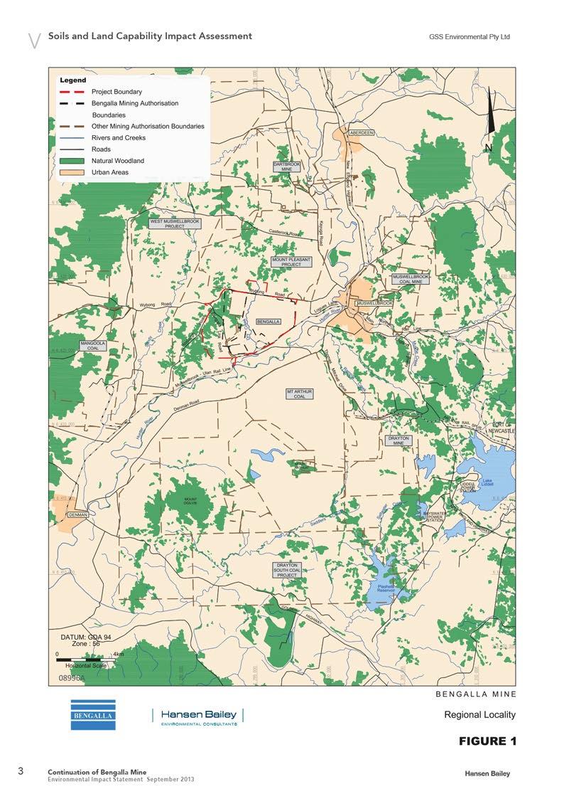
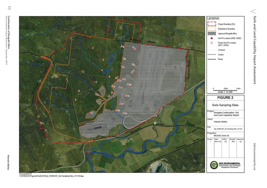
10 1.1 Project Description and Project Boundary Bengalla is located in the Upper Hunter alley of NSW, approximately 130 km north-west of Newcastle and 4 km west of the township of Muswellbrook (Figure 1). Bengalla is a strip mining, open cut operation where current mining advances in a westerly direction based on dragline strips approximately 60 m in width. Overburden is removed by two methods: a truck and excavator operation, and through the use of a dragline. Coaling is undertaken by a truck and excavator operation. The Project Boundary for the entire Bengalla Lease encompasses an area of 2,341 ha. The Survey Area within the Project Boundary relevant to this report encompasses an area of 1,370 ha which includes a Disturbance Boundary of 964 ha. A soil survey covering 390 ha of the Project Boundary has been previously undertaken by Global Soil Systems (GSS) as documented in Bengalla Coal Mine: Soil Survey Report (GSS, 2005). The soils component of this report focuses on the Disturbance Area of 1,370 ha, the majority of which occurs west of Dry Creek. Continuation of Bengalla Mine 2
11
12 1.2 Assessment Objectives The major objectives of the assessment undertaken by GSSE were to: Objective 1 Objective 2 Objective 3 Objective 4 Objective 5 Classify and provide a description and mapping of the soil types within the Project Boundary; Provide a description and mapping of the pre and post mining land capability within the Project Boundary; Provide a description and mapping of the pre and post mining agricultural suitability within the Project Boundary; Provide recommendations for stripping depths of proposed disturbance areas, including any recommendations for topsoil handling, stockpiling and amelioration for reuse in rehabilitation; and Describe necessary erosion and sediment control measures to manage disturbed in-situ and stockpiled soil resources. This report outlines the methodology and results of the soil and land capability assessment conducted to satisfy the assessment objectives. This includes background research, field assessment, laboratory analysis of soil samples sourced from within the Project Boundary and proposed soil management measures. 1.3 Standards To satisfy Objective 1 of the Soil and Land Capability Impact Assessment (the Assessment): The soil taxonomic classification system utilised was the Australian Soil Classification System (Isbell, 1996); The soil survey system implemented with regard to survey type and scale was the Guidelines for Surveying Soil and Land Resources (NCST, 2008). This is a recognised guideline for Australian soil and land capability assessments; and The soil survey system to be applied with regards to recording information from field soil survey observations is the Australian Soil and Land Survey Field Handbook (NCST, 2009). This is a recognised guideline for Australian soil and land capability assessments. To satisfy Objective 2 of the Assessment, Rural Land Capability classification was conducted in accordance with the requirements of the NSW Department of Trade and Investment, Regional Infrastructure and Services (DTIRIS). This system was introduced by the Soil Conservation Service of NSW and the relevant guideline is provided in Systems Used to Classify Rural Lands in New South Wales (Emery, 1986). To satisfy Objective 3 of the Assessment, Agricultural Suitability Classification was conducted in accordance with the requirements of the DTIRIS. This system was introduced by the former NSW Agricultural & Fisheries Service of NSW and the relevant guideline is provided in the Agricultural Suitability Maps uses and limitations (NSW Agricultural & Fisheries, 1990). To satisfy Objective 4 of the Assessment, the system implemented to determine which soils are suitable for conserving and utilising in the Project s rehabilitation program was the Soils and Extractive Industries (Elliot & Reynolds, 2007). This procedure assesses soils based on grading, texture, structure, consistence, mottling, and root presence. The approach described in this guideline remains the benchmark for land resource assessment in the Australian mining industry. Continuation of Bengalla Mine 4
13 To satisfy Objective 5 of the Assessment, the Australian guideline Managing Urban Stormwater: Soils and Construction olume 2E Mines and Quarries (Department of Environment and Climate Change, 2008) was utilised to describe the necessary erosion and sediment control measures to manage disturbed in situ and stockpiled soil resources. 1.4 Director General s Requirements Director General s Requirements (DGRs) were issued on March 13th, 2012, for the Continuation of Bengalla Mine Project (SSD-5170). Within these DGRs, several are relevant for this report, namely: The EIS must address the following specific matters: Land Resources including an Agricultural Impact Statement and a detailed assessment of the potential impacts on: o o Soils and land capability (including salinisation and contamination); Landforms and topography, including steep slopes; and Water Resources including: o Details and staging for the proposed Dry Creek re-diversion. This report focusses on the Land Resources component of the EIS requirements (excluding contamination), although the Dry Creek diversion and issues surrounding it are also discussed here. These will be elaborated on in the forthcoming Bengalla Continuation Rehabilitation Management Strategy. 5 Continuation of Bengalla Mine
14 2.0 BIOPHYSICAL ENIRONMENT 2.1 Climate The Project Boundary is located in the Hunter region of NSW, typically having a cool temperate climate with moderately dry winters and wetter summers. The annual average rainfall is mm with the majority of this rainfall falling in the summer months of December to February (Muswellbrook (Lower Hill St) Bureau of Meteorology (BOM) station No , 2012). Temperatures within the region range from an average monthly maximum of C in January to an average monthly minimum of C in July (Jerry Plains Post Office BOM station No , 2011). The average annual evaporation within the Project Boundary ranges between mm (Average pan Evaporation (Annual) Map 2008 BOM Product Code: IDCJCM0006) (BOM, 2008; 2012). 2.2 Hydrology and Topography The Project Boundary is located within the Hunter River catchment, specifically the Hunter Residual subcatchment. This sub-catchment is a planform controlled, meandering river, containing gravelly sediments and can be primarily characterised as a sediment transfer zone. Medium energy flow transports sediment, gravel and sand in this sub-catchment. The topography within the Project Boundary is typical of the Bayswater soil landscape unit (Kovac & Lawrie, 1991) and is characterised by low to undulating hills that range from Reduced Level (RL) 40 to 220 m with slopes generally ranging between 3 to 10%. Small areas have gently to moderately inclined slopes of 10-18%. A Hunter River tributary, Dry Creek is located to the within the Disturbance Boundary and drains in a southerly direction. This Creek is a minor tributary of the Hunter River and is ephemeral in nature, only flowing during periods of prolonged or intense rainfall. The Creek bed is predominately covered in grasses and weeds, with riparian vegetation scattered and severely disturbed after an extensive period of grazing. Erosion is evident in sections of the Creek and its tributaries. 2.3 Geomorphic Domains and Geology Bengalla is located in the Central Lowlands topographic zone within the Sydney Basin geological province. Two soil landscape units underpin the Project Boundary. These are the Roxburgh and Bayswater soil landscapes as delineated by the Soil Landscapes of the Singleton 1:250,000 Sheet (Kovac & Lawrie, 1991). The Bayswater soil landscape describes soils that have formed from the underlying Permian Singleton Coal Measures on landscapes with between m RL (Reduced Level) with an elevation of RL 140 to 220 m. These measures are composed of sandstone shale, mudstone, conglomerate and coal parent material and have been derived from ancient marine sediments. Due to the sediments origin, salt levels are usually high and soils are often dispersive and highly erodible with sheet and gully erosion common landscape features. The Roxburgh soil landscape also describes soils that have formed from Permian Singleton Coal Measures on slightly higher and steeper landscapes with between m local relief. These measures also comprise sandstone, shale, mudstone, conglomerate and coal which has in situ weathered parent rock material derived from colluvium. The Roxburgh unit covers undulating low hills and undulating hills with an elevation of m ASL (Above Sea Level) and minor to moderate sheet erosion. Soils are primarily yellow podzolic soils (Yellow Chromosols) on upper to midslopes with red solodic soils (Red Sodosols) and brown podzolic soils (Brown Chromosols) on upper concave slopes, and Lithosols (Rudosols/Tenosols) on steeper slopes. Continuation of Bengalla Mine 6
15 2.4 egetation and Land Use The Project Boundary has been mostly cleared for agriculture and is dominated by grasslands, although some areas of woodland remain. The original character of the vegetation has been greatly altered as a result of previous agricultural land use. Small patches of remnant woodland vegetation occur in the western portion of the Project Boundary, which provide the majority of habitat for flora and fauna including habitat for several threatened species. Landuse in the surrounding area is a mixture of open cut mining activity and grazing. In areas close to the Hunter River, more intensive agricultural practices (e.g. cropping) are undertaken. The majority of the area surrounding Bengalla Mine has been heavily modified by agricultural practices and mining activity. 7 Continuation of Bengalla Mine
16 3.0 SOIL SUREY AND ASSESSMENT This section outlines the methods used to conduct the soil survey component of the assessment and reports the results of the survey. 3.1 Soil Survey Methodology Both a field survey and a desktop study were undertaken within the Project Boundary Reference Map An initial soil map (reference map) was developed using the following resources and techniques: Aerial photographs and topographic maps; Aerial photo and topographic map interpretation was used as a remote sensing technique allowing detailed analysis of the landscape, and mapping of features expected to be related to the distribution of soils within the Project Boundary. Reference information; Source materials were used to obtain correlations between pattern elements and soil properties that may be observable in the field. The materials included Cadastral data, prior and current studies of physiographic, geological, vegetation and water resource elements. Previous reports; Soil Landscapes of the Singleton 1:250,000 Sheet (Kovac and Lawrie, 1991); Soil Survey for the Proposed Bengalla Coal Mine (Envirosciences Pty Ltd, 1993); Bengalla Coal Mine Soil Survey Report (GSS, 2005); and Soil and Land Capability Impact Assessment, Bengalla Development Consent Modification (GSSE, 2010). Stratified observations Following the production of a broad soil map, surface soil exposures, topography and vegetation throughout the Project Disturbance Area were visually assessed to verify potential soil types, delineate soil type boundaries, and determine preferred locations for targeted subsurface investigations (hereafter referred to as soil pits) Field Survey Methodology Two approaches were used to map soils within the 1,370 ha Survey Area: a field survey, to cover the area which will be severely affected by the open cut mining process, and mapping extrapolated from the field survey, supporting information and reconnaissance for the area within the Disturbance Boundary that will be minimally affected by open cut mining. Continuation of Bengalla Mine 8
17 The field survey was undertaken at a medium intensity scale of 1:50,000, enabling the production of a map sufficiently detailed for project and district-level planning. To satisfy this scale, in accordance with the Guidelines for Surveying Soil and Land Resources (NCST, 2008), the number of observations per unit area required is 4 observations per 100 ha. For the field survey area, 10 representative sites were selected for full soil profile descriptions (excavated pits). Additionally, numerous field observations (e.g. details recorded from cuttings, stream banks, shovel excavations) were taken where possible, satisfactory to meet the required observation density. A description of the field observation categories is provided in Table 1. Table 1 Field Observation Categories Class Observation Type Description Actual Number for Project 1 Detailed profile description Soil pit excavation with soil profile described in accordance with the Australian Soil Survey Handbook (NCST, 2009) Deep borings Deep borings examine material below the normal depth of the soil description and are important where subsolum and substrate properties influence land use. This is particularly so where irrigated land use is proposed. No irrigated land was assessed during the survey or is proposed for the Project, meaning that soil description beyond the normal depth, via deep borings, was not necessary. 0 3 Laboratory soil assessment Samples were taken from 10 Class 1 observations (soil pits) with each identified layer assessed for many level C and D type analyses as specified in Table 17.9 of the Guidelines for Surveying Soil and Land Resources. 10 (pits) Minor field observations are brief observations to confirm mapping boundaries, soil type distributions or other characteristics being mapped in the survey. 4 Minor field observations These are always brief, and generally constitute the majority of field observations in soil surveys due to the efficiency in gathering good quality field data to supplement and refine detailed information collected using Type I observations. 20 Mapping observations during the survey included exposed cuttings, exposure of topsoil to 40 cm using a spade, vegetation associations and rock outcrops. Total 40 The field survey was undertaken as a Free Survey where observations were irregularly located according to the survey team s judgement based on reference map interpretation with survey information obtained across traverses where soil type was expected to change. Observations were in the form of soil profile descriptions from pits and/or soil profile exposures. Detailed descriptions accompanied sampling of representative soil profiles for subsequent laboratory analysis. 9 Continuation of Bengalla Mine
18 Soil Field Assessment Ten exposed soil profiles were assessed across the Project Boundary that focused on areas within the Disturbance Boundary. The soil profile locations are shown in Figure 2. Each soil profile exposure pit was excavated to the required depth of 1.2 m and to a suitable width to receive maximum light on the profile exposure from which the samples were removed. All pits were backfilled immediately after assessment. All soil profiles were assessed for soil type and distribution, with 31 samples taken from the ten pits for subsequent laboratory analysis. Soil profiles within the Project Boundary were assessed in accordance with the Australian Soil and Land Survey Field Handbook (NCST, 2009) soil classification procedures. Detailed soil profile descriptions recorded information that covered the parameters as specified in Table 2. Soil profile logging was undertaken in the field using soil data sheets. Global Positioning System (GPS) recordings were taken for all sites where detailed soil descriptions were undertaken. egetation type and land use were also recorded. Soil exposures from excavated pits were photographed during field operations as colour photography of profile sites is a useful adjunct to description of land attributes. Soil layers from each test pit were also assessed according to a procedure adapted from Elliot and Reynolds (2007) for the recognition of suitable topdressing material. This procedure assesses soils based on grading, texture, structure, consistency, mottling and root presence. A more detailed explanation of the Elliot and Reynolds procedure is presented in Section 5 of this report. Table 2 Detailed Soil Profile Description Parameters Descriptor Horizon Depth Field Colour Field Texture Grade Boundary Distinctness and Shape Consistence Force Structure Pedality Grade Structure Ped & Size Stones Amount & Size Roots Amount & Size Ants, Termites, Worms etc Application Weathering characteristics, soil development Permeability, susceptibility to dispersion/erosion Erodibility, hydraulic conductivity, moisture retention, root penetration Erosional/dispositional status, textural grade Structural stability, dispersion, ped formation Soil structure, root penetration, permeability, aeration Soil structure, root penetration, permeability, aeration Water holding capacity, weathering status, erosional/ depositional character Effective rooting depth, vegetative sustainability Biological mixing depth Soil Laboratory Assessment Soil samples from ten soil profile sites were utilised in a laboratory testing programme. Samples were analysed to determine: Soil taxonomy; Land capability and agricultural suitability classification; and Suitability of soil as topdressing media. Continuation of Bengalla Mine 10
19
20 The laboratory test results were used in conjunction with the field assessment results to determine the depth of soil material that is suitable for stripping and re-use for the rehabilitation of disturbed areas. Soil samples of approximately 1 2 kg were collected from each soil layer. In total, 31 soil samples were sent to the Department of Lands (Scone Research Centre) for analysis. A certificate of analysis for these results is contained in Appendix 2. The selected physical and chemical laboratory analysis parameters, and their relevant application, are listed in Table 3. All samples were laboratory tested for relevant physical and chemical parameters (Table 3). Their application to the soil and land assessment is also described in Table 3 for each parameter. A description of the significance of each test and typical values for each soil characteristic is included in Appendix 2. The laboratory test results were used in conjunction with the field assessment results to determine the depth of soil material that is suitable for recovery and use as a growth medium for rehabilitation of disturbed areas. Similarly, potentially unfavourable soil material was identified. The soil test results for the soil survey are provided in Appendix 2. Table 3 Laboratory Analysis Parameters Property Application Physical: Colour Coarse fragments (>2mm) Particle-size distribution (<2mm) Aggregate stability (Emerson Aggregate Test) Soil colour based on Munsell Colour chart. Soil workability; root development; droughtiness Nutrient retention; exchange properties; erodibility; droughtiness; workability; permeability; sealing; drainage; interpretation of most other physical and chemical properties and soil qualities Susceptibility to surface sealing under rainfall or irrigation; effect of raindrop impact and slaking; permeability; infiltration; aeration; seedling emergence; correlation with other properties Chemical: Soil reaction (ph) (1:5, soil: water suspension) Electrical conductivity (EC) (1:5, soil: water suspension) Cation exchange capacity (CEC) and exchangeable cations Organic Carbon (OC) (%) Nutrient availability; nutrient fixation; toxicities (especially Al, Mn); liming; sodicity; correlation with other physical, chemical and biological properties Appraisal of salinity hazard in soil substrates or groundwater, total soluble salts Nutrient status; calculation of exchangeable sodium percentage (ESP); assessment of other physical and chemical properties, especially dispersivity, shrink swell, water movement, aeration Essential nutrient for plant growth The laboratory methods used by Scone Research Centre for each physical and chemical parameter are provided in Table 4. Table 4 Laboratory Test Methods Analyte Method Particle Size Analysis (PSA) ph Electrical conductivity Emerson Rating CEC & exchangeable cations Sieve & hydrometer 1:5 soil/water extract 1:5 soil/water extract Emerson Aggregate Test (EAT) (AgTU)+ extraction Continuation of Bengalla Mine 12
21 Mapping Observations Mapping observations consisted of exposed cuttings (such as cut slopes), topsoil exposure of up to 40 cm using a spade, vegetation cover associations and rock outcrops. These were utilised to confirm mapping boundaries, soil type distributions and any other characteristics being mapped in the survey. This information generally constitutes the majority of field observation data collected in soil surveys (NCST, 2008) and is used to refine information collected from detailed soil profile observations Soil Classification The applicable technical standard adopted for naming the types of soil identified within the Project Boundary is the Australian Soil Classification (ASC) system (Isbell, 1996). 3.2 Soil Survey Results Soil Types Overview Eight soil types were identified within the Project Boundary. Table 5 provides an overview of each soil type and their quantitative distribution within the Project Boundary (final percentage is rounded). Figure 3 illustrates the spatial distribution of soil types. Table 5 Soil Types Overview Soil Type # Australian Soil Classification Name Area (%) Survey Area Area (ha) 1 Brown Chromosol Red Chromosol Brown ertosol Red Sodosol Brown Kurosol Deep Brown Sodosol () Brown Sodosol Rudosol Total 100 1,370 The distribution of these soils is illustrated in Figure 3. Exposed profiles of major soil units and landscape photos of areas where each soil unit was observed are shown in Plates 1 to 12. A glossary of commonly used soils terms is presented in Appendix 1. All soil interpretations have been derived from Hazelton & Murphy (2007) unless otherwise stated. Colour was analysed on moist samples unless they were bleached layers. 13 Continuation of Bengalla Mine
22


23 3.2.2 Soil Type 1 Brown Chromosol Soil Type 1 is a Brown Chromosol and covers 46.2% of the Project Boundary. A soil profile overview, physical characteristics and laboratory results are presented in Table 6. It is derived from sandstone shale, mudstone, conglomerate and coal parent materials from the Singleton Coal Measures. This soil type complex has well developed duplex profiles with fine loamy surfaces overlying dark brown clay subsoils containing red mottles. This soil type is located on the less steep waning slopes (slope <5%). These soils are reasonably fertile and less susceptible to sheet and gully erosion when managed to their correct capacity, as compared to the soil covering the steeper waxing slopes. Land that is accessible for agriculture has been grazed in the past. Sheet erosion and gully erosion is likely to occur if protective vegetative cover is removed. Table 6 Overview: Brown Chromosol Site Description Plate 1 Profile (Pit 2) Plate 2 Landscape (Pit 2) ASC Soil Type Brown Chromosol; moderate Sample Pit 2 Dominant Geology Association Shale, conglomerate floaters ( mm) Dominant Slope Association Mid-slope; very gently to gently inclined (3-10%) Land Use and egetation Land Capability Class Erosion Risk Class Soil Stripping Recommendation Cattle grazing, isolated ironbark, spear grass, wheat grass, red grass Class limited by slope, sodicity, depth to BC Topsoil K-factor = 0.04; moderate erosion risk m Highly suitable; subsoil unsuitable due to fine texture and high dispersability 15 Continuation of Bengalla Mine
24 Horizon Depth (m) Description Physical Characteristics A B B BC Dark Brown (7.5YR3/4) moderate consistence silty clay loam. Sub angular blocky 5-25 mm. Roots fine/medium and common. Boundary is clear and wavy. Dark Brown (7.5YR3/4) heavy clay, strong consistence, strong structure (angular blocky mm). Roots fine/medium and common up to 60 cm. Boundary is gradual and wavy. Dark Brown (7.5YR3/4), strong consistence silty clay. Strong (prismatic mm). Roots fine/medium and common up to 60 cm. Boundary clear and even. Red, strong consistence clay throughout, decomposing parent material. Sub angular blocky mm, roots few and fine to 70 cm. Boundary is gradual and wavy. C Conglomerate, sandstone and shale. Analytical Description Analyte Units A1 B21 B22 Depth m Colour Munsell Dark brown Dark brown Dark brown ph ph unit 6.6 Neutral 5.9 Moderately acid 8.0 Moderately alkaline EC ds/m 0.2 Non-saline 0.02 Non-saline 0.3 Non-saline CEC meq/100g 25.4 High 26.9 High 31.7 High ESP % 3.9 Non-sodic 2.6 Non-sodic 11.4 Moderately sodic EAT Class 3(1) Slight 3(3) Moderate 2(1) High-Moderate Continuation of Bengalla Mine 16

.")
25 3.2.3 Soil Type 2 Red Chromosol Soil Type 2 is a Red Chromosol and covers 7.6% of the Project Boundary. A soil profile overview, physical characteristics and laboratory results are presented in Table 7. It is derived from sandstone, shale, mudstone, conglomerate and coal parent materials from the Singleton Coal Measures. This soil type has well developed duplex profiles with silty clay loam surfaces overlying heavy clay to silty clay subsoils. This soil type is located on the steeper waxing slopes (slope >5%). These soils are less susceptible to sheet and gully erosion when managed to their correct capacity, as compared to the less steep waning slope soils. They do not have sodic subsoils which are highly susceptible to sheeting when the surface is exposed or disturbed. Land that is accessible for agriculture has been grazed in the past. Sheet erosion and gully erosion is likely if protective vegetative cover is removed. Table 7 Overview: Red Chromosol Site Description Plate 3 Profile (Pit 9) Plate 4 Landscape (Pit 9) ASC Soil Type Sample Pit Dominant Geology Association Red Chromosol 9 mapped as a Brown Chromosol but similar to soils found in this soil mapping unit Shale, sandstone, mudstone, conglomerate Dominant Slope Association Upper slope; gently inclined (3-10%) & moderately inclined (10-18%) Land Use and egetation Land Capability Class Erosion Risk Class Soil Stripping Recommendation Grazing cattle; Red Ironbark, Kurrajong, Native Grasses Class I Topsoil K-factor = 0.04; moderate erosion risk m Highly suitable; subsoil unsuitable due to fine texture 17 Continuation of Bengalla Mine
26 Horizon Depth (m) Description Physical Characteristics A B B Dark Brown (7.5YR3/4) moderate consistence silty clay loam. Moderate pedality rough faced peds (sub angular blocky mm). Boundary clear and wavy. Yellowish Red (5YR4/6) strong consistence heavy clay. Strong pedality smooth faced peds (angular-blocky mm). Roots course and abundant up to 30 cm. Boundary gradual and wavy. Dark Brown (7.5YR4/6) strong consistence silty clay. Moderate pedality smooth faced peds (sub angular blocky to prismatic mm). Boundary clear and even to BC layer. Analytical Description Analyte Units A1 B21 B22 Depth m Colour Munsell Dark Brown Yellowish Red Dark Brown ph ph unit 6.8 Neutral 7.4 Mildly alkaline 8.5 Strongly alkaline EC ds/m 0.2 Non-saline 0.1 Non-saline 0.2 Non-saline CEC meq/100g 20.2 Moderate 29.5 High 34.5 High ESP % 4.3 Non-sodic 4.0 Non-sodic 4.6 Non-sodic EAT Class 3(1) Slight 3(1) Slight 4 Negligible Continuation of Bengalla Mine 18


27 3.2.4 Soil Type 3 Brown ertosol Soil Type 3 is a Brown ertosol and covers 12.6% of the Project Boundary. A soil profile overview, physical characteristics and laboratory results are presented in Table 8. It is derived from sandstone, shale, mudstone, conglomerate and coal parent materials from the Singleton Coal Measures. This soil type exhibits a gradational profile and has a silty clay topsoil and heavy clay subsoil. Cracking was in evidence at the surface of this soil type. This soil type is located on the plateaued benches of lower and midslopes, as well as lower slopes in the south of the Project Boundary. These soils are generally not susceptible to sheet or gully erosion when managed to their correct capacity, as compared to duplex soils with sodic characteristics. The land associated with this soil type has been extensively cleared for grazing, however, vegetation cover on the soil has largely been continual and this has prevented enhanced runoff and sheet erosion that is commonly associated with agricultural activities. Table 8 Overview: Brown ertosol Site Description: Soil Type 3 Plate 5 Profile (Pit 10) Plate 6 Landscape (Pit 10) ASC Soil Type Brown ertosol Sample Pit 10 Dominant Geology Association Dominant Slope Association Land Use and egetation Land Capability Class Erosion Risk Class Soil Stripping Recommendation Shale Flat areas on mid-slopes/ lower slopes Grazing, isolated White Box with cotton bush shrubs and white top grasses (Danthonia spp.) Class I (sodicity at depth) Topsoil K-factor = 0.025; moderate erosion risk m suitable for stripping; subsoil unsuitable because of texture, alkalinity and sodicity. 19 Continuation of Bengalla Mine
28 Horizon Depth (m) Description Physical Characteristics A A B B Dark Brown (7.5YR3/4) strong consistence silty clay. Moderate pedality (angular blocky 20-50mm) earthy face peds. Boundary gradual and wavy. Dark Reddish Brown (5YR3/4) strong consistence heavy clay. Strong pedality (angular blocky 20-50mm) smooth face peds. Boundary diffuse and irregular. Dark Reddish Brown (5YR3/4) strong consistence heavy clay. Strong pedality (angular blocky mm) smooth face peds. Boundary clear and irregular. Yellowish Brown (10YR5/6) moderate consistence silty clay. Moderate pedality (subangular prismatic mm) rough faced peds. Analytical Description Analyte Units A1 A21 B1 B2 Depth m Colour Munsell Dark brown Dark reddish brown Dark reddish brown Yellowish brown ph ph unit 7.2 Neutral 8.2 Moderately alkaline 8.7 Strongly alkaline 9.2 ery strongly alkaline EC ds/m 0.1 Non-saline 0.2 Non-saline 0.2 Non-saline 0.7 Non-saline CEC meq/100g 26.4 High 37 High 37.3 High 37.9 High ESP % 3 Non-sodic 4.9 Non-sodic 5.9 Non-sodic 10.8 Moderately sodic EAT Class 8 Negligible 3(1) Slight 3(1) Slight 4 Negligible Continuation of Bengalla Mine 20


29 3.2.5 Soil Type 4 Red Sodosol Soil Type 4 is a Red Sodosol and covers 13.9% of the Project Boundary. A soil profile overview, physical characteristics and laboratory results are presented in Table 9. It is derived from sandstone, shale, mudstone, conglomerate and coal parent materials from the Singleton Coal Measures. This soil complex has well developed duplex profiles with clay loam surfaces overlying heavy clay subsoils. This soil type is located on the gently to very gently inclined midslopes (slope 3-10%). These soils are susceptible to sheet and gully erosion due to the dispersive nature of their subsoils. Incorrect management practices can lead to the topsoil being detached and cause enhanced erosion rates when the subsoil is exposed. Land that is accessible for agriculture has been grazed in the past but currently is not used for agriculture and the condition of the soil is improving due to the increased ground cover of native pastures and invading weeds. However, sheet erosion and consequential gully erosion is likely if protective vegetative cover is removed. Table 9 Overview: Red Sodosol Site Description: Soil Type 4 Plate 7 Profile (Pit 13) Plate 8 Landscape (Pit 13) ASC Soil Type Red Sodosol Sample Pit 13 Dominant Geology Association Sandstone and shale Dominant Slope Association Midslope; gently to very gently inclined (3-10%) Land Use and egetation Land Capability Class Erosion Risk Class Soil Stripping Recommendation Cattle grazing; Forest Oak regrowth, native grasses, weed species Class Topsoil K-factor = Moderate risk m suitable for stripping; subsoil unsuitable because of texture and sodicity 21 Continuation of Bengalla Mine
30 Physical Characteristics Horizo n Depth (m) Description A B B BC ery Dark Brown (7.5YR2.5/3) weak consistence clay loam. Moderate pedality (subangular blocky mm), earthy faced peds. Many course roots. Boundary clear and even. Dark Red (2.5YR3/6) strong consistence heavy clay. Strong pedality (angular blocky mm) smooth faced peds. Fine and course roots common. Boundary diffuse and even. Yellowish Red (5YR4/6) strong consistence heavy clay. Strong pedality (angular blocky mm) sandy faced peds. Fine common roots. Boundary clear and irregular. Yellowish Brown moderate consistence clay. Moderate pedality (sub angular prismatic mm) rough faced peds. Fine few roots. Analytical Description Analyte Units A1 B21 B22 Depth m Colour Munsell ery dark brown Dark red Yellowish red ph ph unit 6.6 Neutral 8.2 Moderately alkaline 8.9 Strongly alkaline EC ds/m 0.1 Non-saline 0.2 Non-saline 1.0 High ery High CEC meq/100g 18 Moderate 31.6 High 39.4 High ESP % 3.9 Non-sodic 10.4 Moderately sodic 18.0 Strongly sodic EAT Class 2(1) High-moderate 2(2) High 2(2) High Continuation of Bengalla Mine 22


31 3.2.6 Soil Type 5 Brown Kurosol Soil Type 5 is a Brown Kurosol and covers 3.1% of the Project Boundary. A soil profile overview, physical characteristics and laboratory results are presented in Table 10. It is derived from sandstone, shale, mudstone, conglomerate and coal parent materials from the Singleton Coal Measures. This soil complex has well developed duplex profiles with loam to sandy loam surfaces overlying sandy clay subsoils. This soil type is located on the level to very gently inclined slopes of lower slopes and drainage lines (slope 0-3%). These soils are susceptible to sheet and gully erosion due to the high erodibility and dispersive nature of their subsoils. Incorrect management practices can lead to the topsoil being detached and cause enhanced erosion rates when the subsoil is exposed. Land that is accessible for agriculture has been grazed in the past but currently is not used for agriculture. Sheet erosion and consequential gully erosion is likely if protective vegetative cover is removed by intensifying agricultural activity or by localised flooding. Table 10 Overview: Brown Kurosol Site Description: Soil Type 5 Plate 9 Profile (Pit 4) Plate 10 Landscape (Pit 4) ASC Soil Type Brown Kurosol; deep Sample Pit 4 Dominant Geology Association Shale Dominant Slope Association Lower slope (within drainage line); level to very gently inclined (0 3%) Land Use and egetation Land Capability Class Erosion Risk Class Soil Stripping Recommendation Grazing cattle, native grasses and forbes; 100% ground cover Class I Topsoil K-factor = 0.04; Moderate risk m suitable; m marginally suitable; A2 and B2 subsoil unsuitable for stripping due to combination of acidity, sodicity and dispersability 23 Continuation of Bengalla Mine
32 Horizon Depth (m) Description Physical Characteristics A A Dark Brown (7.5YR3/3) weak consistence loam. Weak pedality (sub angular blocky mm) earthy face peds. Boundary gradual and weak. Strong Brown (7.5YR4/6) weak consistence sandy loam. Apedal. Boundary diffuse and wavy. A Bleached (7.5YR4/6) weak consistence clay loam. Apedal. Boundary clear and irregular. B Strong Brown (7.5YR5/6) moderate consistence sandy clay. Sandy fabric (sub angular blocky mm). Analytical Description Analyte Units A11 A12 A2 B2 Depth m Colour Munsell Dark brown Strong brown Strong brown Strong brown ph ph unit 5.9 Moderately acid 5.5 Strongly acid 5.7 Moderately acid 4.9 ery strongly acid EC ds/m 0.08 Non-saline 0.02 Non-saline 0.02 Non-saline 0.09 Nonsaline CEC meq/100g 7.3 Low 4.2 ery low 6.1 Low 12.1 Moderate ESP % 5.5 Non-sodic 4.8 Non-sodic 8.2 Moderately sodic 14.9 Strongly sodic EAT Class 8 Negligible 8 Negligible 2(1) 2(1) Highmoderate Highmoderate Continuation of Bengalla Mine 24

33 3.2.7 Soil Type 6 Brown Sodosol Soil Type 6 is a Brown Sodosol; mapped at two depths within the Project Boundary. The Brown Sodosol Deep (>100 cm) to weathered material covers 5.9% of the Project Boundary. A soil profile overview, physical characteristics and laboratory results are presented in Table 11. It is derived from sandstone shale, mudstone, conglomerate and coal parent materials from the Singleton Coal Measures. The Brown Sodosol Deep occurs on level to slightly undulating flats and gullies. Sheet erosion and gully erosion is likely if protective vegetative cover is removed due to localised flooding. The Brown Sodosol - Moderately Deep is located on the less steep waning slopes (slope <5%). These lower slope soils are more fertile and less susceptible to sheet and gully erosion when managed to their correct capacity, as compared to soils on steeper waxing slopes. Land that is accessible for agriculture is grazed. A variant of this soil type (Soil Type 6) is present as a Brown Sodosol - Moderately Deep (<75 cm). It covers 10.8% of the Disturbance Boundary. The laboratory and physical characteristics of the Brown Sodosol - Deep are representative for the variation (excluding depth range). Table 11 Overview: Brown Sodosol Site Description: Soil Type 6 Plate 11 Profile (Pit 5) Plate 12 Landscape (Pit 5) ASC Soil Type Brown Sodosol Deep (representative) & Brown Sodosol - Moderately Deep. Sample Pit 5 Dominant Geology Association Shale Dominant Slope Association Broad gully floor; level to very gently inclined (0-3%) Land Use and egetation Land Capability Class Erosion Risk Class Grazing; mixed grasses Deep - Class I; waterlogging potential with severe erosion possible; Moderately Deep Class I Topsoil K-factor = 0.30, Moderate 25 Continuation of Bengalla Mine
34 Soil Stripping Recommendation Horizon Depth (m) Description m: Highly suitable; subsoil unsuitable due to highly dispersive, sodic properties Physical Characteristics A A A B Dark Brown (7.5YR3/4) strong consistence clay loam. Moderate pedality (sub angular blocky mm) earthy peds. Boundary is diffuse, even. Brown (7.5YR4/3) strong consistence clay loam. Moderate pedality (sub angular blocky mm) earthy peds. Boundary is diffuse, even. Dark Brown (7.5YR3/4) strong consistence clay loam. Moderate pedality (sub angular blocky mm) earthy peds. Boundary is clear, wavy. Brown (7.5YR4/4) moderate consistence light clay. Moderate pedality (sub angular blocky mm) earthy peds. Analytical Description Analyte Units A11 A12 A13 B2 Depth m Colour Munsell Dark brown Brown Dark brown Brown ph ph unit 7.2 Neutral 7.3 Neutral 8.1 Moderately alkaline 9.1 ery strongly alkaline EC ds/m 0.0 Non-saline 0 Non-saline 0 Non-saline 0.2 Non-saline CEC meq/100g 21 Moderate 20.3 Moderate 18.4 Moderate 22.6 Moderate ESP % 1.9 Non-sodic 2.5 Non-sodic 3.8 Non-sodic 15.0 Strongly sodic EAT Class 8 Negligible 3(1) Slight 3(2) Slight 2(3) ery high Continuation of Bengalla Mine 26
35 3.2.8 Soil Type 7 Rudosol Soil Type 7 is a Rudosol; mapped from aerial reconnaissance information and existing soils maps; as such, no laboratory results are available. Rudosols, with a variable depth to bedrock, cover 16.1% of the Project Boundary. They are derived from sandstone shale, mudstone, conglomerate and coal parent materials from the Singleton Coal Measures (Table 12). Rudosols occur primarily in the western area of the Project Boundary and occur on upper slopes to crests. Sheet and gully erosion is likely if protective vegetative cover is removed, however native vegetation is still commonly found on steeper, rockier slopes. Land that is accessible for agriculture is lightly grazed. Table 12 Overview: Rudosol Site Description: Soil Type 7 ASC Soil Type Sample Pit Dominant Geology Association Rudosol N/A Inferred from supporting data and field observations Shale, sandstone, mudstone Dominant Slope Association Upper slopes and crests (>10%) Land Use and egetation Land Capability Class Erosion Risk Class Soil Stripping Recommendation Light Grazing; native trees and mixed grasses Class II; shallow, sandy loam soils on steep slopes and crests N/A 0 cm: Not suitable; shallow, sandy with bedrock at 35 cm 27 Continuation of Bengalla Mine
36 4.0 LAND ASSESSMENT The Project Boundary has been assessed for its Rural Land Capability and Agricultural Suitability classification. The methods and results for both these assessments are presented in this section fulfilling report Objectives 2 and Rural Land Capability Assessment Methodology The land capability system applied to the Project Boundary is in accordance with the DTIRIS (formerly the NSW Soil Conservation Service) classification system. The relevant guideline is called Systems Used to Classify Rural Lands in New South Wales (Cunningham et al., 1988). This system classifies the land on its potential for sustainable agricultural use if developed, rather than its current land use, and includes three types of land uses: Land suitable for cultivation; Land suitable for grazing; and Land not suitable for rural production. The system consists of eight classes, which classify the land based on the severity of long-term limitations. Limitations are the result of the interaction between physical resources and a specific land use. A range of factors are used to assess this interaction. These factors include climate, soils, geology, geomorphology, soil erosion, topography and the effects of past land uses. The principal limitation recognised by these capability classifications is the stability of the soil mantle and classes are ranked on their increasing soil erosion hazard and decreasing versatility of use. A description of the eight land capability classes (and special zonings) is provided in Table 13. Table 13 Rural Land Capability Classes Class Land Use Management Options I Regular Cultivation No erosion control requirements II Regular Cultivation Simple requirements such as crop rotation and minor strategic works III Regular Cultivation Intensive soil conservation measures required such as contour banks and waterways I Grazing, occasional cultivation Simple practices such as stock control and fertiliser application Grazing, occasional cultivation Intensive soil conservation measures required such as contour ripping and banks I Grazing only Managed to ensure ground cover is maintained II Unsuitable for rural production Green timber maintained to control erosion III Unsuitable for rural production Should not be cleared, logged or grazed Special Zonings U Urban areas Unsuitable for rural production SF State Forests Unsuitable for rural production M Mining & quarrying areas Unsuitable for rural production Source: Cunningham et al., 1988 Continuation of Bengalla Mine 28
37 4.1.2 Land Capability Results The relevant pre-mining land capability classification land within the Project Boundary is quantified in Table 14. The spatial distribution of the pre-mining land capability classification is shown in Figure Pre-Mining The Project Boundary is composed of land capability classes II, I,, I and II. Overall, the major limitations impacting land capability classification within the Project Boundary are slope, soil depth, sodicity, acidity/alkalinity, waterlogging potential and erosion risk. Class II Land Class II land consists of Soil Type 3 (Brown ertosol), specifically land located on low slope areas in the southern extent within the Project Boundary. This classification indicates that the land is suitable for regular cultivation and cropping. Class I Land Class I land consists of Soil Type 3 (Brown ertosol), specifically land located on several flat areas west of Dry Creek. This classification indicates that the land is suitable for grazing with only occasional cultivation. This class of land is limited by its sodicity at depth. The choice of plants is restricted and the land requires careful management. This land is capable of pasture improvement and can be tilled for an occasional crop. The preferred pasture establishment method for this land class is no-till or zero tillage and pasture grass cover should be maintained at >70% with a minimum height of 5 cm. Class Land Class land consists of Soil Types 1 (Brown Chromosol), 2 (Red Chromosol) and 4 (Red Sodosol). Class land is only suitable for grazing with very occasional cultivation. If cultivated then intensive soil conservation measures are required such as contour ripping and banks. Similar to Class I, this land is considered to be moderately productive and suited to improved pasture. However, higher level management practices are required due to slope and/or higher erosion risks as compared to Class I land. Class I Land Class I land consists of Soil Type 5 (Brown Kurosol), Soil Type 6 and Soil Type 6 () (Brown Sodosol Deep and Moderately Deep, respectively). This classification indicates that the land must not be cultivated for cropping or for establishing pasture, however, the land can be used for grazing if careful management and stocking practices are implemented. Soil Type 5 is constrained by its shallow topsoil depth, acidity and susceptibility to erosion due to inherent sodicity. Pasture improvement is recommended via by no-till practices, specifically, aerial broadcasting of seed. Soil Types 6 and 6 () are found in and adjacent to Dry Creek. It is likely that Soil Type 6 is a buried soil profile, with up to 60 cm of the upper profile material likely derived from erosional processes upslope. Whilst this material is of reasonable quality, the lower profile material is very alkaline, strongly sodic and highly dispersive and as a significant drainage line, prone to periodic high velocity water flows and waterlogging. This combination of factors makes it unsuitable for cultivation (which would exacerbate the erosion risk) and it is important for an adequate vegetation cover to be maintained to minimise erosion potential. 29 Continuation of Bengalla Mine
38
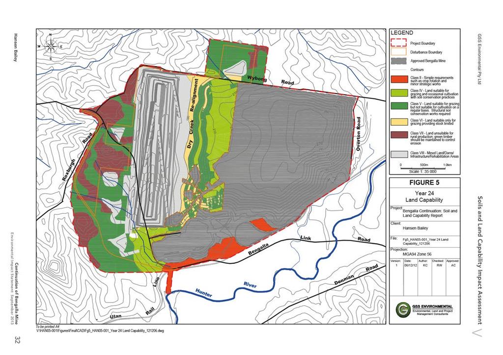
39 Class II Land Class II land consists of Soil Type 7 (Rudosol). This classification indicates that the land is unsuitable for rural production and green timber should be maintained to control erosion. Soil Type 7 tends to be sandy and of variable, shallow depth to bedrock and as such, has not been as extensively cleared as other soil types. It is often found in areas or rocky outcrop and becomes increasingly prevalent in the western areas of the Project Boundary, at higher elevations. Table 14 Pre-Mining Rural Land Capability for the Project Boundary Class Pre-Mining Associated Soil Type % ha I - Nil Nil II III - Nil Nil I , 2, I 5, 6, 6() II III - Nil Nil M - Nil Nil Total 100% 1, Post-Mining The post-mining Land Capability classification is indicative only, as the baseline data provided is illustrative of the conceptual 24 year mine plan. Post-mining land capability is illustrated in Figure 5. The landforms associated with the year 24 mining surface design for the Project Boundary are predominately flats and slopes, commonly up to 18% and occasionally up to 32%. These landforms are typically associated with Classes II to I. Where the final void is located, steep slopes will likely render this land unsuitable for agricultural production and this land will be classified Rural Land Capability III. The conceptual 24-year mine plan currently shows this area as Special Zoning M (land disturbed by Mining). Class II land can be re-instated where Brown ertosol material is salvaged and then re-instated, although the total land area will be limited in extent. Class I land can be extensively re-instated where slope varies between 3-10%. On slopes over 10%, land will require careful management and is limited to Classes, I or Il. This land is suitable for low intensity grazing only, or where the land falls under Class II, land should be returned to green timber to stabilise slopes and minimise erosion. 31 Continuation of Bengalla Mine
40
41 4.2 Agricultural Suitability Assessment Methodology The Agricultural Suitability classification system applied to the assessment is in accordance with the NSW DPI (formerly NSW Agriculture & Fisheries) guideline. The relevant guideline is the Agricultural Suitability Maps Uses and Limitations (NSW Agriculture & Fisheries, 1990). The system consists of five classes, providing a ranking of rural lands according to their productivity for a wide range of agricultural activities with the objective of determining the potential for crop growth within certain limits. Class 1 ranks the land as most suitable for agricultural activities and Class 5 the least suitable. Classes 1 to 3 are generally considered suitable for a wide variety of agricultural production, whereas, Classes 4 and 5 are unsuitable for cropping however are suitable for some grazing activities The overall suitability classification for each specific soil type is determined by the most severe limitation, or a combination of the varying limitations. A description of each Agricultural Suitability Class is provided in Table 15. Table 15 Agricultural Suitability Classes Class Land Use Management Options 1 Highly productive land suited to both row and field crops. 2 Highly productive land suited to both row and field crops. 3 Moderately productive lands suited to improved pasture and to cropping within a pasture rotation. 4 Marginal lands not suitable for cultivation and with a low to very low productivity for grazing. 5 Marginal lands not suitable for cultivation and with a low to very low productivity for grazing. Source: NSW Agriculture & Fisheries (1990) Arable land suitable for intensive cultivation where constraints to sustained high levels of agricultural production are minor or absent. Arable land suitable for regular cultivation for crops but not suited to continuous cultivation. Grazing land or land well suited to pasture improvement. It may be cultivated or cropped in rotation with pasture. Land suitable for grazing but not for cultivation. Agriculture is based on native or improved pastures established using minimum tillage. Land unsuitable for agriculture or at best suited only to light grazing Agricultural Suitability Results The main soil properties and other landform characteristics considered significant for the Agricultural Suitability assessment are topsoil texture, topsoil ph, solum depth, external and internal drainage, topsoil stoniness and slope as well as bio-physical factors such as elevation, rainfall and temperature Pre-Mining Table 16 quantifies the relevant pre-mining Agricultural Suitability classes for the Project Boundary. Figures 6 and 7 shows the spatial distribution of the pre and post-agricultural suitability classes respectively. 33 Continuation of Bengalla Mine
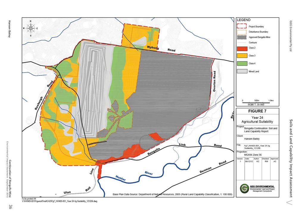
42 Table 16 Pre-Mining Suitability Classes Agricultural Suitability Class Land Capability Class Soil Type # Project Boundary ha % 2 II I, 1, 2, 3, I, II 5, 6, 6(), Class 2 Land Class 2 land consists of Soil Type 3 (Brown ertosol). This class indicates that the land is highly productive and suitable for regular cultivation for crops, but not suited to continuous cultivation. A limitation for land classified as Class 2 is the disjointed nature of the land and its close proximity to mining infrastructure. Class 3 Land Class 3 land consists of Soil Types 1 (Brown Chromosol), 2 (Red Chromosol), 3 (Brown ertosol) and 4 (Red Sodosol). This class indicates that the land is moderately productive and well suited to grazing with pasture improvement, or to an occasional crop with a pasture rotation. A major limitation for land classified as Class 3 is slope gradient of up to 10%, and its main constraints limiting cultivation frequency are soil structure breakdown and erosion hazard. All soil types display a moderate erosion risk and soil conservation and drainage works are likely to be required if the land is to be used for anything other than grazing activity. Class 4 Land Class 4 land consists of Soil Types 5 (Brown Kurosol), Soil Type 6 and Soil Type 6 () (Brown Sodosol Deep and Moderately Deep, respectively) and Soil Type 7 (Rudosols). This classification indicates that this land must not be cultivated for cropping or for establishing pasture grasses, however, the land can be used for grazing if careful management and stocking practices are implemented. Grazing productivity is low to very low and pastures are to be based on native or improved pastures established with zero or minimum tillage techniques. Although production may be high seasonally, the overall level of production is low as a result of a number of major constraints, both environmental and edaphic. A major constraint for Soil Types 5, 6 and 6 () in this Class is their association with water and prolonged water logging conditions. Erosion risk in this environment is high due to periodic water flow combined with weak soil structure due to sodic subsoils. The cultivation of these soils for agriculture, which involves removal of the protective vegetative cover, will facilitate rapid erosion processes. These erosion processes typically take the form of tunnel and gully erosion leading to severe land degradation. Sodicity, in addition to increasing the tendency of the soil particles to disperse in wet conditions can also negatively affect plant root growth depending on plant type and other soil conditions Post-Mining The conceptual post-mining landforms are typically associated with Agricultural Suitability Classes 3 and 4. Given the dominant existing surrounding land uses, the post mining land use of the Project Boundary is best suited to low intensity grazing. On areas where steeper slopes occur, cattle grazing should be minimised and a good cover of pasture maintained. The return of local box woodland species would also increase the habitat value of the land and addresses concerns of the Muswellbrook Shire Council (MSC, 2011) regarding increasing the amount of woody vegetation present on post-mining land forms. The re-instated Dry Creek should be managed with particular care to ensure erosion is not exacerbated. Further discussion in relation to the reinstatement of Dry Creek is discussed in Section Where possible, stock grazing should be minimised and riparian vegetation established to increase bank stability. Continuation of Bengalla Mine 34
43
44
45 4.3 Strategic Regional Land Use Policy Upper Hunter The Draft Upper Hunter Strategic Regional Land Use Plan (DP&I, 2012) (SRLUP) is a component of the broader Strategic Regional Land Use Policy, which consists of various initiatives to manage land use conflicts in regional areas, in relation to agriculture, coal mining and coal seam gas. The plan defines strategic agricultural land as: highly productive land that has both unique natural resource characteristics (such as soil and water resources) as well as socio-economic value (such as high productivity, infrastructure availability and access to markets). (DP&I 2012). The plan defines areas of both Biophysical Strategic Agricultural Land (BSAL) and Critical Industry Clusters, including clusters for the equine and viticulture industries. A description of the interactions between mapped strategic agricultural land and the Project is provided below. The Project is moving in a general westerly direction away from the Hunter River alluvial floodplain and mapped BSAL. The important values and criteria that relate to BSAL are outlined in Table 17, which also shows where each is addressed in this report. The Gateway Criteria (and where they are addressed in this report) are outlined in Table 18. Table 17 Strategic Agricultural Land alues and Criteria alue Criteria Where Addressed Biophysical Strategic Agricultural Land Critical Industry Cluster (Equine and iticulture) Land that falls under soil fertility classes high or moderately high under the Draft Inherent General Fertility of NSW (OEH), and Land capability classes I, II or III under the Land and Soil Capability Mapping of NSW (OEH), and Reliable water of suitable quality, characterised by having rainfall of 350mm or more per annum (9 out of 10 years); or properties within 150m of a regulated river, or unregulated rivers where there are flows for at least 95% of the time (i.e. the 95th percentile flow of each month of the year is greater than zero) or 5th order and higher rivers; or groundwater aquifers (excluding miscellaneous alluvial aquifers, also known as small storage aquifers) which have a yield rate greater than 5L/s and total dissolved solids of less than 1,500mg/L. land that falls under soil fertility classes moderate under the Draft Inherent General Fertility of NSW (OEH), and land capability classes I or II under the Land and Soil Capability Mapping of NSW (OEH), AND reliable water of suitable quality, characterised by having rainfall of 350mm or more per annum (9 out of 10 years); or properties within 150m of a regulated river, or unregulated rivers where there are flows for at least 95% of the time (i.e. the 95th percentile flow of each month of the year is greater than zero) or 5th order and higher rivers; or groundwater aquifers (excluding miscellaneous alluvial aquifers, also known as small storage aquifers) which have a yield rate greater than 5L/s and total dissolved solids of less than 1,500mg/L. Industry clusters that meet the following criteria: o There is a concentration of enterprises that provides clear development and marketing advantages and is based on an agricultural product; o The productive industries are interrelated; o It consists of a unique combination of factors such as location, infrastructure, heritage and natural resources; o It is of national and/or international importance; Section of this report Section 4.1 of this report Agricultural Impact Statement (Scott Barnett & Associates, 2013) Agricultural Impact Statement (Scott Barnett & Associates, 2013) Main olume of EIS 37 Continuation of Bengalla Mine
46 alue Criteria Where Addressed o o o It is an iconic industry that contributes to the region s identity; and It is potentially substantially impacted by coal seam gas or mining proposals. Source: Draft Upper Hunter Strategic Regional Land Use Plan, (DP&I, 2012) Table 18 Gateway Criteria alue Gateway Criteria Where Addressed Site erification Whether the mapped land does not meet the criteria for biophysical strategic agricultural land and/or the critical industry cluster Throughout report Biophysical Strategic Agricultural Land Impacts on the land through surface area disturbance and subsidence; Impacts on: o Soil fertility o Rooting depth, or o Soil profile materials and thickness. Increases in land surface microrelief or soil salinity, or significant changes to soil PH, and Impacts on Highly Productive Groundwater, including the provisions of the Aquifer Interference Policy and the advice on the Minister for Primary Industries (note that the Minister for Primary Industries will be required to take into account the advice of the Commonwealth Independent Expert Scientific Committee on Coal Seam Gas and Large Coal Mining Development in providing advice in this stage). Section of this report Section of this report Section 3; 4.3 Agricultural Impact Statement (Scott Barnett & Associates, 2013) Critical Industry Cluster (Equine and iticulture) Whether the proposal would lead to significant impacts on the critical industry cluster through: o Surface area disturbance Agricultural Impact Statement (Scott Barnett & Associates, 2013) o Subsidence Not Applicable o o o o Reduced access to agricultural resources Reduced access to support services and infrastructure Reduced access to transport routes Loss of scenic and landscape values Agricultural Impact Statement (Scott Barnett & Associates, 2013) Agricultural Impact Statement (Scott Barnett & Associates, 2013) Agricultural Impact Statement (Scott Barnett & Associates, 2013) Agricultural Impact Statement (Scott Barnett & Associates, 2013) Continuation of Bengalla Mine 38
47 4.3.1 Biophysical Strategic Agricultural Land The Study Area has been assessed against the maps and criteria provided with the SRLUP and ground truthed during the soil and land capability survey, to gain an appreciation of the extent and likely impact of the Project on potential Biophysical Strategic Agricultural Land (BSAL). The Project is located adjacent to the Hunter River alluvial floodplain which is mapped under the criteria for BSAL (Scott Barnett & Associates, 2013). Approximately 28 ha of BSAL falls within the Project Boundary. This area of mapped BSAL within the Project Boundary is largely associated with the Approved Bengalla Mine or is currently used for grazing associated with dairying. A small area of approximately 1 ha of BSAL mapped land is located within the Disturbance Boundary and is associated with the realignment of Bengalla Road Critical Industry Cluster (Equine & iticulture) The Project Boundary, based on Map 6 of the SRLUP, also contains a small area of land which occurs within the Equine Critical Industry Cluster as defined as having a slope of less than 18% and being within the 2km of the Muswellbrook Denman Road (DP&I, 2012). There is no land within the Disturbance Boundary which occurs within into the Equine Critical Industry Cluster. The Appendix of the SRLUP provides a definition for the iticulture Critical Industry Cluster as presented on Map 6 of the SRLUP (DP&I, 2012). This definition and how it has been used to verify the iticulture Critical Industry Cluster in detailed in the Agricultural Impact Assessment (Scott Barnett & Associates, 2013). Table 19 iticulture Critical Industry Cluster Definition Where Addressed The iticulture Critical Industry Cluster is spatially defined as the following land (excluding State Forests and National Park): The Broke-Fordwich and Pokolbin Geographical Indicators (GI) sub-regions; The parish of Belford and the suburbs of Lovedale, Nulkaba, Mount iew and Rothbury; Properties proximate to the Hunter Wine Country Private Irrigation District pipeline to the east of Lovedale Road as well as those properties bounded by Mears Lane, Majors Lane and the Suburb of Lovedale; and Land (excluding National Park and State Forests) within 20 km of Denman; and that falls under soil fertility classes high, moderately high, moderate or moderately low under the Draft Inherent General Fertility of NSW (OEH, 2012a), and land capability classes I, II, III, I or under the Land and Soil Capability Mapping of NSW (OEH, 2012b) and is within 2 km of a mapped alluvial water source. Not Applicable Not Applicable Not Applicable Not Applicable 39 Continuation of Bengalla Mine
48 Table 20 - iticulture Critical Industry Cluster erification Definition Land (excluding National Park and State Forests) within 20 km of Denman; and Falls under soil fertility classes high, moderately high, moderate or moderately low under the Draft Inherent General Fertility of NSW (OEH, 2012a); and Land capability classes I, II, III, I or under the Land and Soil Capability Mapping of NSW (OEH, 2012b); and Is within 2 km of a mapped alluvial water source. Within Project Boundary Yes - Agricultural Impact Statement (Scott Barnett & Associates, 2013) Yes See Section Yes See Section Yes Agricultural Impact Statement (Scott Barnett & Associates, 2013) As described above the Project Boundary lies within the Equine Critical Industry Cluster, the iticulture Critical Industry Cluster and mapped BSAL, an assessment has been conducted against the gateway criteria for BSAL and the Equine and iticulture Critical Industry Clusters as provided in the SRLUP. No existing vineyards occur within the Project Boundary or Disturbance Boundary. The nearest operating vineyards are located approximately 6 km south of the south east corner of the Project Boundary and 14.5 km west of the western Project Boundary (Scott Barnett & Associates, 2013). There is limited area of 494 ha within the Project Boundary mapped as iticulture Critical Industry. The verified iticulture Critical Industry Cluster within the Disturbance Boundary is 369 ha. The Agricultural Impact Assessment has determined that the Project will not impact significantly on iticulture Critical Industry Cluster nor any component of the viticulture industry in the Hunter alley (Scott Barnett & Associates, 2013). In the 1,370 ha of land assessed in this report, only 56 ha is mapped as Class II land, with all the remaining land mapped as Class I or higher. Some land in the south of the Project Boundary is Class II land, given its location relative to Hunter River alluvials and other soils in the area being mapped as Class II land in similar landscape locations. However, only 1 ha of Class II land is located within the Disturbance Boundary, the remaining Class II land will remain undisturbed and continue to be used for agricultural purposes. Despite the existence of this Class II land within the Project Boundary, the operations of the Project are likely to have little to no impact on this land which is currently being used for agricultural production, which will continue. Future mining disturbance will not affect this area and as such there is unlikely to be surface area disturbance, soil fertility or rooting depth effects, or other physical / chemical effects on the soil. Continuation of Bengalla Mine 40
49 4.3.3 Soils and the SRLUP The assessment of soil fertility results conducted on nine of the samples for the soil survey indicates that all soils have low to moderate fertility under the Draft Inherent General Fertility of NSW OEH, 2012a). Table 21 - Inherent and Interpreted Soil Fertility Soil Type OEH Draft Inherent Fertility Interpreted Fertility Soil Test Sample ID (see Appendix 3) Red Chromosol Moderate Moderately Low Sample P9-1 Brown Chromosol Moderate Moderately Low Sample P2-1, P8-1, P-12-1 Brown ertosol Moderate Moderate Sample P3-1 Red Sodosol Moderately Low Moderately Low Sample P13-1 Brown Kurosol Moderately Low Moderately Low Sample P4-1 Deep Brown Sodosol Moderately Low Moderately Low Sample P5-1 Brown Sodosol Moderately Low Moderately Low Not Tested Rudosol Low Low Not Tested With the exception of the Brown ertosol, all soil types are extremely low to very low in nitrogen and phosphorus. This led to the interpreted fertility in Table 21 being slightly different to the OEH Inherent Fertility. Appendix 3 contains full details of the soil fertility test data run on nine samples (sample depth of 0-10 cm). Salinity is not an issue for topsoil management. Only the Red Sodosol soil type displays salinity (at depth in the B horizon), however this material is not recommended for stripping due to a range of other physical and chemical attributes Acid Sulphate Soils Acid sulfate soils are naturally occurring soils, sediments or organic substrates (e.g. peat) formed under waterlogged conditions that contain iron sulfide minerals (predominantly as the mineral pyrite) or their oxidation products. When exposed to the air following the lowering of the water table (through, for example. dewatering, groundwater abstraction, drainage or excavation) the sulfides in these soils readily oxidise, releasing sulfuric acid and iron into the soil and groundwater. This acid can, in turn, release aluminium, nutrients and heavy metals (particularly arsenic) held within the soil matrix (Ahern et al., 2004). Acid sulfate soils, which are the main cause of acid generation within the soil mantle, are commonly found less than 5 m above sea level, particularly in low-lying coastal areas. Bengalla Mine is located within Upper Hunter alley region (approximately 130 km from the coast) and has an elevation range of m above sea level. It is therefore unlikely that acid sulfate soils (to a depth of 1.5 m) are present at Bengalla. Given that any identified BSAL is likely to remain under agricultural production (grazing and cropping) and no land currently within the Project Boundary is utilised for any equine industry related uses, the continuation of Bengalla Mine should not trigger any issues with the Equine Critical Industry Cluster located in the area. 41 Continuation of Bengalla Mine
50 5.0 IMPACT ASSESSMENT AND MITIGATION MEASURES Continuation of mining will disturb land to the west of the current Bengalla Mine. This land has been widely cleared and is primarily used for cattle grazing, with some small areas of remnant (albeit modified) native vegetation, primarily Grassy Box woodland. Each component of the Project has a construction and operational disturbance footprint with some parts of the disturbance footprint being progressively rehabilitated immediately after construction with the remainder being rehabilitated at the end of operational use. This report provides information on the following key areas related to the management of topsoil resources for the area within the Disturbance Boundary: Dry Creek Reinstatement; Soil erosion hazard assessment which assesses potential soil erosion during land disturbance activities; Soil resource assessment which assesses soil quality for salvage and re-use for rehabilitation works; Topsoil management recommendations of stripped and salvaged soil resources; and Erosion and sediment control recommendations to be implemented on the site. Soil to be disturbed has been assessed to determine its capability for stripping and re-use on rehabilitation sites. This assessment is an integral process for successful rehabilitation within the Project. This report provides information on the following key areas related to the management of the topsoil resources at Bengalla: Topsoil stripping assessment which provides a topsoil stripping plan indicating recommended stripping depths for topsoil salvage and re-use as topdressing media in rehabilitation; and Topsoil management for soil that is stripped, stored and re-spread as a topdressing material for rehabilitation. 5.1 Dry Creek Reinstatement Dry Creek is an ephemeral creek that generally only flows following intense rainfall periods due to its relatively small catchment area. Dry Creek occasionally holds small pools of water for a few days following rainfall events. As mining progresses to the west, it is anticipated that Dry Creek will be intercepted at Year 2 of operations. As such, the construction of a water storage dam and interim diversion of Dry Creek will be required to divert clean water around mining operations through the use of a pipe network. Prior to the completion of mining, a permanent re-alignment of Dry Creek will be constructed to ensure successful stabilisation. The predominant soil type identified in Dry Creek is a deep Brown Sodosol. It should be noted that in the vicinity of the sample pit (the southern portion of the Project Boundary), it appears as though the original soil profile has been buried by eroded material up to 50 cm in depth. This material is a clay loam with minimal profile development. It is likely this is colluvial material derived from adjacent low hills and from higher up in the Dry Creek catchment and its minor tributaries. Continuation of Bengalla Mine 42
51 5.2 Soil Erosion Hazard Methodology Soil erosion can be a significant hazard on and downstream of construction sites where vegetative cover is disturbed and the soil is subject to the erosive agents of water and wind. Soil erosion and sedimentation occurs when soil particles detach and are transported offsite. This detachment is affected by a range of site specific factors. The main factors to consider for the assessment of the Disturbance Boundary are soil erodibility and steepness of terrain. Soil erodibility is quantified using the soil erodibility factor (hereafter referred to as the K factor, derived from the Universal Soil Loss Equation). Soil texture is the principle component affecting K, however, other factors such as soil structure, soil organic matter content as well as soil profile permeability also contribute to the soil s inherent soil erodibility. Soils that have the highest erodibility are those which have weak bonds between soil particles and contain an abundance of easily transportable soil particles. Soil erodibility has been determined on the A1 topsoil texture class, with interpretation based on Hazelton & Murphy (2007) Soil Erosion Hazard Assessment The Project Boundary covers land that has a moderate K-factor and soil erosion hazard ratings. This hazard is predominately present due to the sodicity and fine texture (high clay content) of many soils in the B horizon. Table 23 summarises the erosion hazard ratings for the Project Boundary. Table 23 Soil Erosion Hazard Soil Type Project Boundary Dominant Slope K Factor 1 Erosion Hazard Ha % Description Rating Rating Brown Chromosol ery gently to gently inclined 0.04 Moderate Red Chromosol Gently to moderately inclined 0.04 Moderate Brown ertosol Level to very gently inclined Moderate Red Sodosol Brown Kurosol ery gently to gently inclined Level to very gently inclined 0.03 Moderate 0.04 Moderate Deep Brown Sodosol Level to very gently inclined 0.03 Moderate Brown Sodosol ery gently to gently inclined 0.03 Moderate Rudosol Moderately to steeply inclined; crests N/A High Total 1, K factor determined on A1 topsoil texture class, with interpretation based on Hazelton & Murphy (2007) 43 Continuation of Bengalla Mine
52 5.3 Soil Stripping Resource Assessment Methodology Determination of suitable soil to conserve for later use in mine rehabilitation has been conducted in accordance with Elliott and Reynolds (2007). This procedure involves assessing soils based on a range of physical and chemical parameters. These are summarised in Table 24 and further discussed in the text below. Table 24 Topsoil Stripping Suitability Criteria Parameter Structure Grade Coherence Mottling Macrostructure Force to Disrupt Peds Texture Desirable Criteria >30% peds Coherent (wet and dry) Absent >10 cm 3 force Finer than a Fine Sandy Loam Gravel and Sand Content <60% ph 4.5 to 8.4 Salt Content <1.5 ds/m Structural grade is important in terms of the soil s ability to permeate and hold water as well as provide for adequate aeration. These characteristics are essential for the germination and establishment of plants. The ability of water to enter soil generally varies with structure grade and depends on the proportion of coarse peds in the soil surface. Better-structured soils have higher infiltration rates and better aeration characteristics. Structureless soils, without pores, are considered unsuitable as topdressing materials. Soils with structural grades of weak or moderate are considered of low capability for salvage and revegetation works as soil peds are likely to be destroyed and structure can become massive following mechanical work associated with the excavation, transportation and spreading of topdressing material. Consequently, surface sealing and reduced infiltration of water may occur, which will restrict the establishment of plants. The force to disrupt peds, when assessed on soil in a moderately moist state, is an indicator of solidity and the method of ped formation. Dispersive (or deflocculated) soils are hard when dry and slake when wet, whereas flocculated soils produce crumbly peds in both the wet and dry state. The deflocculated soils are not suitable for revegetation and may be identified by a strong force required to break aggregates. The presence of mottling within the soil may indicate reducing conditions and poor soil aeration. These factors are common in soil with low permeabilities; however, some soils are mottled due to other reasons, including proximity to high water tables or inheritance of mottles from previous conditions. Reducing soils and poorly aerated soils are generally unsuitable for revegetation purposes. Gravel and sand content, ph and salinity were determined for all samples using the laboratory test results. Texture was determined in the field and cross-referenced with laboratory results, specifically particle size analysis. All other physical parameters outlined in Table 24 were determined during the field assessment. Continuation of Bengalla Mine 44
53 5.3.2 Soil Stripping Assessment The assessment has shown that the capability of the soil subject to disturbance has a recommended stripping depth stripping depth of m, varying between soil types. The recommended depths correspond to salvage depths via the stripping process and re-used in progressive and post construction rehabilitation works. All subsoils were undesirable for use because of severe physical and/or chemical limitations. The Brown Kurosol topsoils are acidic and would benefit from amelioration with lime to increase soil ph. Table 25 details the maximum recommended stripping depths for each soil type and their major constraints. Figure 8 provides the spatial distribution of the recommended stripping depths. Table 25 Topsoil Stripping Depths Soil Type Recommended Stripping Depth Main Limitation(s) Capability # ASC Name m Description 1 Brown Chromosol Slope, texture Highly Suitable 2 Red Chromosol Slope, texture Highly Suitable 3 Brown ertosol Texture; chemical properties of subsoil Highly Suitable 4 Red Sodosol Texture; sodicity in B horizon Highly Suitable 5 Brown Kurosol Brown Sodosol (Deep) () Brown Sodosol (Moderately Deep) Rudosol 0 Texture, chemical properties of subsoil B horizon sodic, alkaline and highly dispersive B horizon sodic, alkaline and highly dispersive Slope; variable depth to bedrock; texture Suitable Highly Suitable Highly Suitable Unsuitable Laboratory soil analytical results were used in conjunction with the field assessment (refer Appendix 2) to determine the depth of soil material suitable for recovery and re-use as a topdressing material in rehabilitation. Structural and textural properties of subsoils, dispersion potential, sodicity and acidity/alkalinity are the most common and significant limiting factors in determining depth of soil capability for re-use. Allowing for a 10% handling loss, approximately 1,549,800 m 3 of suitable topdressing is available within the entire Disturbance Boundary. The Brown Sodosol and Red & Brown Chromosol soils will generate the largest topsoil resource. Table 26 below provides the recommended stripping depth for each soil unit within the Disturbance Boundary together with the land area occurrence for each soil type and the calculated volume of available soil for re-use in rehabilitation activities. 45 Continuation of Bengalla Mine
54 Table 26 Recommended Stripping Depths Topsoil Soil Type Recommended Stripping Depth (m) Stripping Area (ha) Soil olume m , , , , ,000 6, 6() , Total olume 1,722,000 Total olume with 10% handling loss allowance 1,549,800 Continuation of Bengalla Mine 46
55
56 5.4 Topdressing Management Topsoil Stripping and Handling The following topsoil handling techniques are recommended to prevent excessive soil deterioration. Strip material to the depths stated in Section 5.3, subject to further investigation as required. Topsoil should be maintained in a slightly moist condition during stripping. Material should not be stripped in either an excessively dry or wet condition. Place stripped material directly onto reshaped overburden and spread immediately (if mining sequences, equipment scheduling and weather conditions permit) to avoid the requirement for stockpiling. Grading or pushing soil into windrows with graders or dozers for later collection by open bowl scrapers, or for loading into rear dump trucks by front-end loaders, are examples of preferential less aggressive soil handling systems. This minimises compression effects of the heavy equipment that is often necessary for economical transport of soil material. Soil transported by dump trucks may be placed directly into storage. Soil transported by scrapers is best pushed to form stockpiles by other equipment (e.g. dozer) to avoid tracking over previously laid soil. The surface of soil stockpiles should be left in an as coarsely textured condition as possible in order to promote infiltration and minimise erosion until vegetation is established, and to prevent anaerobic zones forming. As a general rule, maintain a maximum stockpile height of 3 m. Clayey soils should be stored in lower stockpiles for shorter periods of time compared to sandier soils. If long-term stockpiling is planned (i.e. greater than 12 months), seed and fertilise stockpiles as soon as possible. An annual cover crop species that produce sterile florets or seeds should be sown. A rapid growing and healthy annual pasture sward provides sufficient competition to minimise the emergence of undesirable weed species. The annual pasture species will not persist in the rehabilitation areas, but will provide sufficient competition for emerging weed species and enhance the desirable micro-organism activity in the soil. Prior to re-spreading stockpiled topsoil onto reshaped overburden (particularly onto designated tree seeding areas), an assessment of weed infestation on stockpiles should be undertaken to determine if individual stockpiles require herbicide application and / or scalping of weed species prior to topsoil spreading. An inventory of available soil should be maintained to ensure adequate topsoil materials are available for planned rehabilitation activities. Topsoil should be spread to a minimum depth of 0.1 m, more where the resource is available. 5.5 Topsoil Balance An approximate topsoil balance has been determined based on the Year 24 landform. Using this as a basis (and excluding the pit void area), approximately 38 ha will be classed as a Dry Creek re-alignment area ; 118 ha as Class I land (lower slopes) and 117 ha as Class /I land (moderate slopes). It is suggested that the Dry Creek realignment re-instate 0.4 m of topsoil, for which there is adequate resource available from the recommended stripping regime. It is also suggested, where possible, to replace approximately 0.4 m of subsoil in the Dry Creek realignment area in addition to the topsoil. For the low slope Class I land, it is suggested a minimum of 0.2 m of topsoil over 0.4 m of subsoil be re-instated. Again, there are adequate topsoil resources available to fulfil this objective. Continuation of Bengalla Mine 48
57 Finally, for the Class /I land, a minimum or 0.1 m but preferably 0.2 m of topsoil should be re-instated. Where possible, up to 0.2 m of subsoil should also be re-instated. If subsoil is re-instated, 0.1 m of topsoil will be adequate. At this stage of final landform planning, there is adequate topsoil resource available to reinstate 0.2 m of topsoil on the Class /I areas. olumes needed and available for topsoil use are outlined in Table 27. Land Class Ha Table 27 Year 24 Landform Topsoil Balance Topsoil Depth (m) Required olume (m 3 ) Soil Type For Use Available olume (m 3 ) Class I ,000 1, 2 576,000 Class + I ,000 1, 2 576,000 Dry Creek Realignment ,000 3, 6, 6() 990, Erosion and Sediment Control Recommendations The land within the Disturbance Boundary has a moderate erosion hazard rating and as such appropriate erosion and sediment controls will be implemented to ensure that adverse effects of construction and operations activities are minimized. A detailed Erosion and Sediment Control Plan will be developed prior to the commencement of construction works. The principle objectives of the Erosion and Sediment Control Plan are outlined below Minimising Disturbance Land disturbance will be minimised by clearing the smallest practical area of land ahead of construction, as well as ensuring the land is disturbed for the shortest possible and practical time. This will be achieved by: Limiting the cleared width to that required to accommodate the proposed operations; Staging the clearing activities where ever possible so that only the areas which are being actively cleared, therefore, limiting the time the areas are exposed; and Rehabilitating topsoil stockpiles as soon as practical. General vegetation clearing and soil stripping should not be undertaken until earthwork and construction operations are ready to commence. All proposed erosion and sediment control measures will be implemented in advance of, or in conjunction with, clearing activities. Prior to clearing and soil stripping commencing, the limits of these works should be clearly delineated by pegs placed at intervals on each side of the disturbed area by a suitably qualified supervisor. All operations will be planned to ensure that there is no damage to any trees and pasture areas outside the limits to be cleared. Rehabilitation strategies and concepts proposed below have been formulated according to results of industry-wide research and experience Post Disturbance Regrading The main objective of regrading is to produce slope angles, lengths and shapes that are compatible with the proposed land use and not prone to an unacceptable rate of erosion. Integrated with this is a drainage pattern that is capable of conveying runoff from the newly created catchments whilst minimising the risk of erosion and sedimentation. 49 Continuation of Bengalla Mine
58 5.6.3 Control Options The most significant means of controlling surface flow on disturbed areas is to construct contour furrows or contour banks at intervals down the slope. The effect of these is to divide a long slope into a series of short slopes with the catchment area commencing at each bank or furrow. This prevents runoff from reaching a depth of flow or velocity that will cause significant erosion. As the slope angle of the land increases, the banks or furrows must be spaced closer together, although on steeper slopes a point is reached where these structures are so close together as to be no longer effective. 5.7 Summary of Mitigation Bengalla mine has in place comprehensive rehabilitation commitments and these are outlined in the existing Rehabilitation Management Plan (BMC, 2013a) and Landscape Management Plan (BMC, 2013b). Key to these documents are management commitments for soil stripping and management (further detailed within this document), revegetation, progressive rehabilitation, erosion and sediment control, overburden management and reshaping, final void management, monitoring and maintenance and completion criteria. It is suggested that the Dry Creek realignment re-instate 0.4 m of topsoil, and approximately 0.4 m of subsoil in the Dry Creek realignment area in addition to the topsoil. For the low slope Class I land, it is suggested a minimum of 0.2 m of topsoil over 0.4 m of subsoil be re-instated, while for the Class /I land, a minimum or 0.1 m but preferably 0.2 m of topsoil should be re-instated. Where possible, up to 0.2 m of subsoil should also be re-instated. As part of the EIS process for the Bengalla Continuation Project, a Rehabilitation Management Strategy is currently being developed which will address the DGRs regarding rehabilitation and set long term goals for the rehabilitation and relinquishment of the site. The rehabilitation and post-mining management at Bengalla will continue to build upon commitments made in existing documents and will also build upon successful techniques developed and applied at the site. Continuation of Bengalla Mine 50
59 6.0 REFERENCES Ahern C.R, McElnea A.E, Sullivan L.A (2004). Acid Sulfate Soils Laboratory Methods Guidelines. In Queensland Acid Sulfate Soils Manual Department of Natural Resources, Mines and Energy, Indooroopilly, Queensland, Australia. BMC (Bengalla Mining Company Pty Ltd) (2013a) Rehabilitation Management Plan. BMC (Bengalla Mining Company Pty Ltd) (2013b) Landscape Management Plan. BOM (Bureau of Meteorology) (2012), (accessed 20th February 2012). BOM (Bureau of Meteorology) (2008), Bureau of Meteorology, (accessed 20th February 2012). Cunningham G.M., Higginson F.R, Riddler A.M.H and Emery K.A. (1988) Rural Land Capability Mapping, Soil Conservation Service of NSW. Sydney, NSW. Department of Environment and Climate Change (2008) Managing Urban Stormwater: Soils and Construction olume 2E Mines and Quarries. Department of Natural Resources (2005) Land Capability Spatial Data. Resource Information Unit, Hunter Region. DP&I (Department of Planning and Infrastructure) (2012) Draft Upper Hunter Strategic Regional Land Use Plan. Elliot and Reynolds (2007) Soil and Extractive Industries IN: Soils their properties and management: 3 rd Edition (Eds P. Charman & B. Murphy) (Oxford University Press, Australia). Emery, K.A. (1986) Rural Land Capability Mapping. Soil Conservation Service of NSW. Sydney, NSW. Envirosciences Pty Ltd (1993) Soil survey for the proposed Bengalla coal mine. GSS (2005) Bengalla Coal Mine Soil Survey Report. GSSE (2010) Soil and Land Capability Impact Assessment, Bengalla Development Consent Modification. (2012) Continuation of Bengalla Mine Background Document. Hazelton P.A and Murphy B.W. (2007) Interpreting Soil Test Results. CSIRO Publishing, Australia. Isbell, R.F. (1996) Australian Soil Classification. CSIRO Publishing, Australia. Kovac M. and Lawrie J.L Soil landscapes of the Singleton 1:250,000 Sheet Soil Conservation Service of NSW, Sydney. MSC (2011) Muswellbrook Shire Council Land Use Development Strategy (Coal Mine Land Use Component). National Committee on Soil and Terrain (NCST) (2008) Guidelines for surveying Soil and Land Resources. (CSIRO Publishing, Australia). National Committee on Soil and Terrain (NCST) (2009) Australian Soil and Land Survey Field Handbook, 3rd edition (CSIRO Publishing, Australia). NSW Agriculture and Fisheries (1990) Agricultural Suitability Map Uses and Limitations. 51 Continuation of Bengalla Mine
60 NSW Land & Water Conservation (1988) Systems Used to Classify Rural Lands in NSW, NSW 1-9. OEH (Office of Environment and Heritage) (2013a) Draft Inherent General Fertility of NSW OEH (Office of Environment and Heritage) (2013b) The Land and Soil Capability Mapping of NSW. Scott Barnett & Associates (2013) Continuation of Bengalla Mine 52
61 Glossary of Terms and Definitions APPENDIX 1 53 Continuation of Bengalla Mine
62 Glossary of Terms and Definitions Term Definition Acidity A property expressed by the ph value when this is below 7.0 in a soil/water suspension. Aggregate A unit of soil structure usually formed by natural processes in contrast with natural processes, and generally <10 mm in diameter. Alkalinity A property expressed by the ph value when this exceeds 7.0 in a soil/water suspension. Availability General expression referring to the ease with which plants can absorb a particular nutrient form the soil. Available Water Capacity The amount of water in the soil, generally available to plants, that can be held between field capacity and the moisture content at which plant growth ceases. Sometimes also known as the Plant Available Water Capacity. Bulk Density The mass of dry soil per unit bulk volume; a measure of soil porosity, with low values meaning a highly porous soil and vice versa. It does not, however, give any indication of the number, sizes, shapes, distribution or continuity of soil pores. Cation An element with a positive charge. Cation Exchange Process whereby cations interchange between the soil solution and the clay or organic matter complexes in the soil. Cation Exchange Capacity The total amount of exchangeable cations that a soil can adsorb, expressed in centimoles of positive charge per kilogram of soil Clay A soil separate consisting of particles <0.002 mm in equivalent diameter. Consistence Force Consistence force refers to the strength of cohesion and adhesion in the soil. Course Fragments Particles greater than 2mm Electrical Conductivity A measure of the conduction of electricity through water or a water extract of soil. It can be used to determine the soluble salts in the extract and hence soil salinity. The unit of electrical conductivity is the Siemens and soil salinity is normally expressed as decisiemens per meter at 25 C (ds/m). Emerson Aggregate Test A classification of soil aggregates based on their coherence in water. Exchangeable Cation A positively charged ion held on or near the surface of a solid particle by a negative surface charge of a colloid and which may be replaced by other positively charged ions in the soil solution. Continuation of Bengalla Mine 54
63 Term Definition Exchangeable Sodium Percentage Exchangeable sodium fraction expressed as a percentage. Field Texture Grade Field texture is a measure of the behaviour of a small handful of soil when moistened and kneaded into a ball and then passes out between thumb and forefinger. The recommended field texture grades are characterised by the behaviour of the moist bolus. Field Colour The colour of soil material is determined by comparison with a standard Munsell colour chart. Gravel A mixture of coarse mineral particles larger than 2 mm, but less than 75 mm in diameter. Hydraulic Conductivity The flow of water through soil per unit of energy gradient. For practical purposes, it may be taken as the steady state of percolation rate of a soil when infiltration and internal drainage are equal, measured as depth per unit time. Infiltration The downward entry of water into the soil through the soil surface. Leaching The removal of materials in solution from the soil. Mottles Spots, blotches or streaks of subdominant colours different from the matrix colour and also different from the colour of the ped surface. Organic Carbon Gives an estimate of the amount of organic matter in a soil as a percentage by weight. Organic Matter Is the sum of all natural and thermally altered biologically derived organic materials found in the soil. These materials, in various states of decay, include leaf litter, plant roots, branches, living, and dead organism, and excreta. ph (soil) A measure of the acidity or alkalinity of a soil. It represents the negative logarithm of the hydrogen ion concentration in a specified soil/water suspension on a scale of 0 to 14. Parent Material The unconsolidated and more or less chemically weathered mineral or organic matter form which the solumn of soils is developed by pedogenic processes. Particle Size Analysis The laboratory determination of the amounts of the different separates in a soil sample such as clay, silt, fine sand, coarse sand and gravel. The amounts are normally expresses as percentages by weight of dry soil. Ped A unit of soil structure such as an aggregate, crumb, prism, block or granule, formed by natural processes (in contrast with a clod which is artificially formed). Permeability (soil) The ease with which gases, liquids or plant roots penetrate or pass through a bulk mass of soil or layer of soil. Physical Properties (soil) Those characteristics, processes or reactions of a soil which is caused by physical forces and which can be described by, or expressed in, physical terms or equations. These can be difficult to separate from chemical properties; hence terms, physical-chemical or physico-chemical. 55 Continuation of Bengalla Mine
64 Term Definition Pores The part of the bulk volume of the soil not occupied by soil particles. Sampling Site A georeferenced point within a monitoring unit where one or more samples are taken for analysis. Sand A soil particle that in the USDA soil texture system is of size 0.05 mm to 2.0 mm in diameter. Silt A soil particle that in the USDA soil texture system is of size mm to 0.05 mm in diameter. Sodicity A property expressed by the amount of exchangeable sodium present relative to the cation capacity of a soil horizon. Soil Classification The systematic arrangement of soils into groups or categories on the basis of similarities and differences in their characteristics. Soil Consistence The resistance of soil material to deformation or rupture. Soil Erodibility The susceptibility of a soil to the detachment and transportation of soil particles by erosive agents. Soil Horizon A layer of soil or soil material approximately parallel to the land surface and differing from adjacent genetically related layers in physical, chemical, biological properties such as colour structure, texture, consistency, kinds and number of organisms present, degrees or acidity or alkalinity. Soil Profile A vertical section of the soil through all its horizons. Soil Salinity The amount of soluble salts in a soil. The convention measure of soil salinity is the electrical conductivity of a saturation extract. Soil Structure Refers to the way soil particles are arranged and bound together to form aggregates or peds. Soil Texture The relative proportions of the various soil separates in as soil as described by the classes of soil texture. It is the general coarseness or fineness of soil material as it affects the behaviour of a moist ball (bolus) when pressed between the thumb and forefinger. Solum The upper part of a soil profile above the parent material, in which current processes of soil formation are active. The solum consists of either the A and B horizons or the A horizon alone when no B is present. Structure Pedality Grade Is the degree of development and distinction of ped. Structure Ped and Size Refers to the distinctness, size and shape of peds. Subsoil Refers to B soil horizon Topsoil Refers to A1 and A2 soil horizons. Continuation of Bengalla Mine 56
65 Soil Laboratory Results APPENDIX 2 57 Continuation of Bengalla Mine

66 SOIL TEST REPORT Scone Research Centre Page 1 of 7 REPORT NO: REPORT TO: REPORT ON: SCO12/040R3 Adele Calandra GSS Environmental PO Box 907 Hamilton NSW 2303 Thirty three soil samples Ref: HAN PRELIMINARY RESULTS ISSUED: 3 March 2012 REPORT STATUS: Final DATE REPORTED: 3 March 2012 METHODS: Information on test procedures can be obtained from Scone Research Centre TESTING CARRIED OUT ON SAMPLE AS RECEIED THIS DOCUMENT MAY NOT BE REPRODUCED EXCEPT IN FULL SR Young (Laboratory Manager) Scone Research Centre, PO Box 283 Scone 2337, 709 Gundy Road Scone 2337 Ph: , Fax: Continuation of Bengalla Mine 58
67 59 Continuation of Bengalla Mine Report No: Client Reference: SCO12/040R3 Adele Calandra GSS Environmental PO Box 907 Hamilton NSW 2303 SOIL CONSERATION SERICE Scone Research Service Centre Lab No Method P7B/2 Particle Size Analysis (%) P9B/2 Colour Sample Id clay silt f sand c sand gravel EAT Dry Moist 1 P1-1 nt nt nt nt nt nt 7.5YR5/3 7.5YR3/3 2 P1-2 nt nt nt nt nt nt 5YR6/4 5YR4/4 3 P (1) 7.5YR5/4 7.5YR3/4 4 P (3) 7.5YR5/4 7.5YR3/4 5 P <1 2(1) 7.5YR5/4 7.5YR3/4 6 P < YR5/3 7.5YR3/2 7 P < YR4/2 7.5YR3/2 8 P <1 4 10YR6/4 10YR4/6 9 P YR5/4 7.5YR3/3 10 P <1 8 10YR6/4 7.5YR4/6 11 P (1) 7.5YR7/4 7.5YR4/6 12 P (1) 7.5YR6/6 7.5YR5/6
68 Report No: Client Reference: SCO12/040R3 Adele Calandra GSS Environmental PO Box 907 Hamilton NSW 2303 SOIL CONSERATION SERICE Scone Research Service Centre Lab No Method P7B/2 Particle Size Analysis (%) P9B/2 Colour Sample Id clay silt f sand c sand gravel EAT Dry Moist 13 P YR5/4 7.5YR3/4 14 P (1) 7.5YR5/4 7.5YR4/3 15 P (2) 7.5YR4/6 7.5YR3/4 16 P (3) 7.5YR5/4 7.5YR4/4 Continuation of Bengalla Mine P YR5/4 7.5YR2.5/2 18 P <1 3(1) 5YR5/4 5YR3/4 19 P <1 4 5YR5/6 5YR4/6 20 P <1 3(1) 7.5YR5/4 7.5YR3/4 21 P (1) 5YR5/4 5YR4/6 22 P < YR5/4 7.5YR4/6 23 P YR4/4 7.5YR3/4 24 P (1) 5YR4/4 5YR3/4 25 P (1) 5YR4/4 5YR3/4 26 P YR6/4 10YR5/6
69 61 Continuation of Bengalla Mine Report No: Client Reference: SCO12/040R3 Adele Calandra GSS Environmental PO Box 907 Hamilton NSW 2303 SOIL CONSERATION SERICE Scone Research Service Centre Lab No Method P7B/2 Particle Size Analysis (%) P9B/2 Colour Sample Id clay silt f sand c sand gravel EAT Dry Moist 27 P YR4/3 7.5YR2.5/3 28 P YR4/6 7.5YR3/4 29 P YR5/4 5YR3/4 30 P YR5/4 5YR4/6 31 P (1) 7.5YR4/3 7.5YR2.5/3 32 P (2) 2.5YR4/4 2.5YR3/6 33 P (2) 5YR5/6 5YR4/6
70 Report No: Client Reference: SCO12/040R3 Adele Calandra GSS Environmental PO Box 907 Hamilton NSW 2303 SOIL CONSERATION SERICE Scone Research Service Centre Continuation of Bengalla Mine 62 Lab No Method C1A/4 C2A/3 C2B/3 C5A/3 CEC & exchangeable cations (me/100g) C6A/2 Sample Id EC (ds/m) ph ph (CaCl 2 ) CEC Na K Ca Mg Al OC (%) 1 P1-1 nt nt nt nt nt nt nt nt nt P1-2 nt nt nt nt nt nt nt nt nt P nt P nt P nt nt 6 P nt P nt P nt nt 9 P nt P P nt 12 P nt
71 63 Continuation of Bengalla Mine Report No: Client Reference: SCO12/040R3 Adele Calandra GSS Environmental PO Box 907 Hamilton NSW 2303 SOIL CONSERATION SERICE Scone Research Service Centre Lab No Method C1A/4 C2A/3 C2B/3 C5A/3 CEC & exchangeable cations (me/100g) C6A/2 Sample Id EC (ds/m) ph ph (CaCl 2 ) CEC Na K Ca Mg Al OC (%) 13 P nt P nt P nt nt 16 P nt nt 17 P <0.1 nt 18 P <0.1 nt 19 P nt nt 20 P <0.1 nt 21 P nt nt 22 P nt nt 23 P <0.1 nt 24 P nt nt 25 P nt nt 26 P nt nt
72 Report No: Client Reference: SCO12/040R3 Adele Calandra GSS Environmental PO Box 907 Hamilton NSW 2303 SOIL CONSERATION SERICE Scone Research Service Centre Continuation of Bengalla Mine 64 Lab No Method C1A/4 C2A/3 C2B/3 C5A/3 CEC & exchangeable cations (me/100g) C6A/2 Sample Id EC (ds/m) ph ph (CaCl 2 ) CEC Na K Ca Mg Al OC (%) 27 P <0.1 nt 28 P nt nt 29 P nt nt 30 P nt nt 31 P <0.1 nt 32 P nt nt 33 P nt nt nt = not tested END OF TEST REPORT

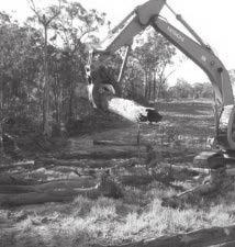

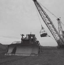
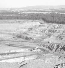
73 Soil Laboratory Results - Fertility APPENDIX 3 65 Continuation of Bengalla Mine

74 EB False Environmental Division CERTIFICATE OF ANALYSIS Work Order : EB Page : 1 of 4 Client : GSS ENIRONMENTAL Laboratory : Environmental Division Brisbane Contact : MR MATT HEMINGWAY Contact : Customer Services Address : LEEL 1241 DENISON STREET Address : 32 Shand Street Stafford QLD Australia 4053 BROADMEADOW NEWCASTLE NSW AUSTRALIA hemingway@gssenvironmental.com Brisbane.Enviro.Services@alsglobal.com Telephone : ---- Telephone : Facsimile : ---- Facsimile : Project : ---- QC Level : NEPM 1999 Schedule B(3) and ALS QCS3 requirement Order number : ---- C-O-C number : ---- Date Samples Received : 28-JUN-2012 Sampler : ---- Issue Date : 12-JUL-2012 Site : ---- No. of samples received : 9 Quote number : BN/372/11 No. of samples analysed : 9 This report supersedes any previous report(s) with this reference. Results apply to the sample(s) as submitted. All pages of this report have been checked and approved for release. Continuation of Bengalla Mine This Certificate of Analysis contains the following information: l General Comments l Analytical Results NATA Accredited Laboratory 825 Accredited for compliance with ISO/IEC Signatories This document has been electronically signed by the authorized signatories indicated below. Electronic signing has been carried out in compliance with procedures specified in 21 CFR Part 11. Signatories Position Accreditation Category Andrew Epps Metals Production Chemist Brisbane Inorganics Ankit Joshi Inorganic Chemist Sydney Inorganics Stephen Hislop Senior Inorganic Chemist Brisbane Inorganics Stephen Hislop Senior Inorganic Chemist Stafford Minerals - AY Address 32 Shand Street Stafford QLD Australia 4053 PHONE Facsimile Environmental Division Brisbane ABN Part of the ALS Group A Campbell Brothers Limited Company 66
Muswellbrook Coal Company No.1 Open Cut Extension Soil Study
 Muswellbrook Coal Company No.1 Open Cut Extension Soil Study November 2001 Table of Contents 1. Introduction... 1 2. Methodology... 1 3. Description of Soil Units Observed... 2 3.1 Yellow Duplex Soils
5 RESULTS FOR THE REJECT EMPLACEMENT AREA
 SPECIALIST CONSULTANT STUDIES 9b - 21 NARRABRI COAL OPERATIONS PTY LTD of the REA, BSA and Water Pipeline Report No. 674/17 5 RESULTS FOR THE REJECT EMPLACEMENT AREA 5.1 Introduction From the information
STATEMENT OF PHYSICAL CHARACTERISTICS AND AGRICULTURAL LAND CLASSIFICATION
 STATEMENT OF PHYSICAL CHARACTERISTICS AND AGRICULTURAL LAND CLASSIFICATION BIRKWOOD FARM, ALTOFTS WEST YORKSHIRE Proposed Opencast Extraction of Clay and coal ADAS January 1990 Leeds Regional Office File
APPENDIX. Soil and Land Capability Impact Assessment
 APPENDIX P P P FINAL Maules Creek Coal Project Soil and Land Capability Assessment November 2010 HAN17-001 P GSS Environmental TABLE OF CONTENTS 1.0 INTRODUCTION... 1 1.1 BACKGROUND... 1 1.2 PROJECT DESCRIPTION...
STATEMENT OF PHYSICAL CHARACTERISTICS AND AGRICULTURAL LAND CLASSIFICATION WITTON PARK, COUNTY DURHAM PROPOSED QUARRY EXTENSION DECEMBER 1992

Appendix 22 Soils and Land Capability
 Appendix 22 Soils and Land Capability March 2009 March 2009 Table of Contents Page No. 1. INTRODUCTION... 1 2. SOIL PROFILING AND MAPPING... 2 2.1 Soil Survey Methodology... 2 2.2 Soil Landscapes... 3
2018 Iowa FFA Soil Judging CDE Exam 1. Landscape positions characterizes the location of the soil on the landscape and identifies potential risks.
 2018 Iowa FFA Soil Judging CDE Exam 1. Landscape positions characterizes the location of the soil on the landscape and identifies potential risks. Which landscape position is considered the floodplain
PROPOSED OPEN CAST COAL SITE SEPTEMBER 1992
 AGRICULTURAL LAND CLASSIFICATION AND STATEMENT OF PHYSICAL CHARACTERISTICS SKIERS SPRING, HOYLAND, SOUTH YORKSHIRE PROPOSED OPEN CAST COAL SITE SEPTEMBER 1992 ADAS LEEDS STATUTORY GROUP Job No. 98/92 MAFF
2014 Iowa FFA Soil Judging CDE Exam
 2014 Iowa FFA Soil Judging CDE Exam 1. Landscape position is one aspect of evaluating the surface features of a certain tract of land. Identifying the correct landscape position will indicate: a. If the
Soil Survey and Land Resource Assessment
 Karuah East Pty Ltd FINAL Soil Survey and Land Resource Assessment Karuah East Quarry Project July 2011 HQP05-002 Table of Contents TABLE OF CONTENTS 1.0 INTRODUCTION... 1 1.1 BACKGROUND... 1 1.2 PROJECT
Unearthing problem soils in the Lachlan Valley
 Vol 24, No 1, page 32 February-March, 2003 The Australian Cottongrower Unearthing problem soils in the Lachlan Valley By Edward Cay and Stephen Cattle, The University of Sydney and Australian Cotton CRC
The entire site supports grass on which sheep had been grazing recently.
 PHYSICAL CHARACTERISTICS REPORT FOR LAND AT HORSEHAY A^ Agricultural Land Classification of approximately 14 hectares of land to the southwest of Horsehay was undertaken in November 1989. The site lies
Iowa FFA Soil Career Development Event 2008
 Iowa FFA Soil Career Development Event 2008 1. In Iowa, corn suitability ratings for soil mapping units specifies a. natural weather conditions b. surface and subsurface drainage installed where needed
AGRICULTURAL LAND CLASSIFICATION AND SOIL PHYSICAL CHARACTERISTICS LAND NEAR SHIRE HILL FARM SAFFRON WALDEN ESSEX
 AGRICULTURAL LAND CLASSIFICATION AND SOIL PHYSICAL CHARACTERISTICS LAND NEAR SHIRE HILL FARM SAFFRON WALDEN ESSEX AGRICULTURAL LAND CLASSIFICATION (ALC) AND SOIL PHYSICAL CHARACTERISTICS LAND NEAR SHIRE
AGRICULTURAL LAND CLASSIFICATION AND SOIL PHYSICAL CHARACTERISTICS BIRCH PIT, NEAR COLCHESTER ESSEX
 AGRICULTURAL LAND CLASSIFICATION AND SOIL PHYSICAL CHARACTERISTICS BIRCH PIT, NEAR COLCHESTER ESSEX AGRICULTURAL LAND CLASSIFICATION AND SOIL PHYSICAL CHARACTERISTICS SEMI-DETAILED SURVEY BIRCH PIT, NEAR
MAFF Ministry of Ifinil Agriculture Rsheries and Food
 MAFF Ministry of Ifinil Agriculture Rsheries and Food STATEMENT OF PHYSICAL CHARACTERISTICS AND AGRICULTURAL LAND CLASSIFICATION SHILBOTTLE COLLIERY RECLAMATION SCHEME NORTHUMBERLAND DECEMBER 1994 ADAS
SUMMARY. alcholnie.doc\ih\jk
 SUMMARY A detailed Statement of Physical Characteristics and Agricultural Land Classification survey of ha of land at Stainton ("Holme Hall Quarry Extension") was carried out in September 1994. At the
APPENDIX I Soils, Land Capability & Agricultural Assessment Report
 APPENDIX I Soils, Land Capability & Agricultural Assessment Report APPENDIX I Soils, Land Capability and Agricultural Assessment 21/18113/148861 Orange Resource Recovery and Waste Management Project Environmental
AGRICULTURAL LAND CLASSIFICATION AND STATEMENT OF PHYSICAL CHARACTERISTICS
 AGRICULTURAL LAND CLASSIFICATION AND STATEMENT OF PHYSICAL CHARACTERISTICS DALE PIT FARM. HATFIELD VOODHOUSE PROPOSED EXTRACTION OF SAND AHD GRAVEL ADAS April 1989 Leeds Regional office File Ref: 2FCS
Loam: About 40% sand, 40% silt, 20% clay. Mixture of pore sizes to balance water retention and aeration. Considered the best soil for growing crops.
 Soil Characteristics Soil is formed from a combination of two Primary sources: Weathering of Parent Rock ( ) = material introduced by plants, animals, and decomposers Minor sources: Nutrients incorporated
Topoclimate Southland Soil Technical Data Sheet No Waiau
 This Technical Data Sheet describes the typical average properties of the specified soil. It is essentially a summary of information obtained from one or more profiles of this soil that were examined and
Horner-McLaughlin Woods: Soil Types
 Horner-McLaughlin Woods: Soil Types Not present at HMW Adrian Muck Conover Loam 0-4% Slopes Houghton Muck Miami Loam 2-6% Slopes Miami Loam 6-12% Slopes Miami Loam 12-18% Slopes t 0 0.125 0.25 Miles Mary
SOIL CHARACTERIZATION USING DIAGNOSTIC PROPERTIES
 SOIL CHARACTERIZATION USING DIAGNOSTIC PROPERTIES The following are the characters of the pedologically important properties used in categorizing soils: SOIL CHARACTERIZATION Soil Profile Description:
AGRICULTURAL LAND CLASSIFICATION AND STATEMENT OF PHYSICAL CHARACTERISTICS
 AGRICULTURAL LAND CLASSIFICATION AND STATEMENT OF PHYSICAL CHARACTERISTICS SEGHILL, NORTHUMBERLAND PROPOSED VASTE DISPOSAL SITE ADAS January 1989 Leeds Regional Office REF: 3/89 2FCS 4191 lds.rpg3.seghill
ARROW BOWEN PIPELINE ENVIRONMENTAL MANAGEMENT PLAN OUTLINE SOIL MANAGEMENT PLAN
 APPENDIX J ARROW BOWEN PIPELINE ENVIRONMENTAL MANAGEMENT PLAN OUTLINE SOIL MANAGEMENT PLAN Contents 1 Introduction... 1 1.1 Purpose of the Soil Management Plan... 1 1.2 Project description... 1 1.3 Legislation
STATE TAX COMMISSION OF MISSOURI ASSESSOR MANUAL
 STATE TAX COMMISSION OF MISSOURI ASSESSOR MANUAL CHAPTER: REVISION DATE: 10/1/2008 Page 1 of 18 7.3 The purpose of this section of the Assessor s Manual is to supplement the State Tax Commission s published
Examining soils in the field. Examining soils in the field. Environment Agency thinksoils examining soils in the field
 Examining soils in the field thinksoils Examining soils in the field Environment Agency thinksoils examining soils in the field 31 Examining soils in the field 32 Environment Agency thinksoils examining
PHYSICAL CHAtlACTERISTICS REPORT FOR THE PROPOSED SAND AND GRAVEL SITE AT MANOR FARM, UFFINGTON
 PHYSICAL CHAtlACTERISTICS REPORT FOR THE PROPOSED SAND AND GRAVEL SITE AT MANOR FARM, UFFINGTON Introduction Following the" request for detailed information on the physical characteristics of soil at Manor
Soil Interpretations Erosion and Sedimentation Control Planning and Design Workshop
 Soil Interpretations Erosion and Sedimentation Control Planning and Design Workshop Presented by Richard Brooks Presentation prepared by Kristin May Resource Soil Scientists USDA-Natural Resources Conservation
2017 Iowa FFA Soil Judging CDE Exam
 2017 Iowa FFA Soil Judging CDE Exam 1. Landscape positions vary in soil composition and makeup. What landscape position would be characterized by having strata and lenses of different textures in the profile:
2011 Wisconsin Envirothon Soils and Land Use Exam
 2011 Wisconsin Envirothon Soils and Land Use Exam USE THE OCONTO COUNTY SOIL SURVEY TO ANSWER QUESTIONS 1-4 The Pensaukee River Wetland Complex is a mixture of state (Pensaukee Wildlife Area) and privately
PHYSICAL CHARACTERISTICS REPORT INCORPORATING AGRICULTURAL LAND CLASSIFICATION LAND AT BOLE INGS, WESTBURTON, NOTTINGHAMSHIRE (SK805875)
") (krahs 2% I?5 PHYSICAL CHARACTERISTICS REPORT INCORPORATING AGRICULTURAL LAND CLASSIFICATION LAND AT BOLE INGS, WESTBURTON, NOTTINGHAMSHIRE (SK805875) 1.0 INTRODUCTION 1.1 The site, an area of 84.5 hectares,
(krahs 2% I?5 PHYSICAL CHARACTERISTICS REPORT INCORPORATING AGRICULTURAL LAND CLASSIFICATION LAND AT BOLE INGS, WESTBURTON, NOTTINGHAMSHIRE (SK805875) 1.0 INTRODUCTION 1.1 The site, an area of 84.5 hectares,
2012 FINAL SOILS AREA 2 Envirothon Questions Answer KEY
 2012 FINAL SOILS AREA 2 Envirothon Questions Answer KEY Questions 1-6 to be answered at the soil pit: 1. Soil scientists categorize soils by drainage classes. What is the drainage class of the soil at
Land Capability Classifications
 Land Capability Classifications Unit: Soil Science Problem Area: Basic Principles of Soil Science Student Learning Objectives. Instruction in this lesson should result in students achieving the following
SOIL DATA: Avondale. in Allen, TX. This information was taken from NRCS web soil survey of Collin County, Texas.
 SOIL DATA: Avondale in Allen, TX This information was taken from NRCS web soil survey of Collin County, Texas. United States Department of Agriculture Soil Conservation Service in cooperation with Texas
In 1983, the town evacuated and purchased by government for $36 million
 1 2 3 4 5 6 7 8 9 Introduction to Environmental Geology, 5e Chapter 17 Soil and Environment Weathering: summary in haiku form Rocks brought to surface decompose to sediment and that's weathering. Case
IOWA FFA STATE SOILS CDE SATURDAY, OCTOBER 13, 2007 AMES, IOWA
 IOWA FFA STATE SOILS CDE SATURDAY, OCTOBER 13, 2007 AMES, IOWA 1. Moderately sloping has what percent slope: a. 9-14% b. 2-5% c. 5-9% d. over 14% 2. Which of the following horizons is the loose underlying
2016 Area 3 Envirothon Muskingum County Soils Test ANSWER KEY
 2016 Area 3 Envirothon Muskingum County Soils Test ANSWER KEY 1. The majority of the bedrock in Muskingum County is. a. sedimentary bedrock b. glacial bedrock c. igneous bedrock d. metamorphic bedrock
Topoclimate Southland Soil Technical Data Sheet No. 8. Sobig
 This Technical Data Sheet describes the typical average properties of the specified soil. It is essentially a summary of information obtained from one or more profiles of this soil that were examined and
 Cci
Cci Unit II Soil Management
 Unit II Soil Management Lesson 2: Using Soil Survey Manuals Soil survey manuals provide useful information for grassland management. Soil scientists evaluate the soil for chemical and physical properties,
AGRICULTURAL LAND CLASSIFICATION REPORT LAND AT BRANT FARM, STOURPORT-ON-SEVERN
 AGRICULTURAL LAND CLASSIFICATION REPORT LAND AT BRANT FARM, STOURPORT-ON-SEVERN INTRODUCTION 1. This report presents the findings of a detailed Agricultural Land Classification (ALC) survey on 12ha of
FINAL AND TEMPORARY REHABILITATION PRINCIPLES. BLOOMFIELD GROUP REPORT 2013 Rix s Creek
 Rix s Creek Lane Singleton NSW 2330 AUSTRALIA PO Box 4 East Maitland NSW 2323 T: 61 2 6578 8888 F: 61 2 6571 1066 ABN 25 003 824 244 FINAL AND TEMPORARY REHABILITATION PRINCIPLES BLOOMFIELD GROUP REPORT
2016 Iowa FFA Soils Evaluation CDE Exam
 2016 Iowa FFA Soils Evaluation CDE Exam 1. Which of the following is true regarding soil horizons? a. A horizon is darker in color and has more organic matter b. B horizon is darker in color and has more
DO YOU KNOW YOUR SOILS? (Rev. 10/11)
") DO YOU KNOW YOUR SOILS? (Rev. 10/11) Circle all the correct answers. 1. What is the layer normally present on the surface of the soil in cropped fields? a. O c. Ap e. B g. R b. A d. E f. C 2. Available
DO YOU KNOW YOUR SOILS? (Rev. 10/11) Circle all the correct answers. 1. What is the layer normally present on the surface of the soil in cropped fields? a. O c. Ap e. B g. R b. A d. E f. C 2. Available
HUMBLEBURN OCCS, CRAGHEAD, COUNTY DURHAM SURVEY OF RESTORED LAND OCTOBER RPT Job Number: 73/97 MAFF Reference: EL LURET Job Number: ME3RTP
 HUMBLEBURN OCCS, CRAGHEAD, COUNTY DURHAM SURVEY OF RESTORED LAND OCTOBER 1997 Resource Planning Team Northern Region FRCA, Leeds RPT Job Number: 73/97 MAFF Reference: EL 10387 LURET Job Number: ME3RTP
Agricultural Land Classification and Statement of Physical Characteristics Higbfield Farm Whitley Bridge North Yorkshire October 1996
 Agricultural Land Classification and Statement of Physical Characteristics Higbfield Farm Whitley Bridge North Yorkshire October 1996 Resource Planning Team ADAS Reference: 82/96 Leeds Statutory Group
SECTION PLANTING SOIL for SOIL CELLS. This specification defines material and performance requirements for soils which are to be used
 This specification defines material and performance requirements for soils which are to be used within the Silva Cell system. The SPECIFICATION EDITOR must select the type of soil appropriate to each particular
ACRE NOOK EAST QUARRY, CHELFORD, CHESHIRE. Statement of Site Physical Characteristics January 1998
 ACRE NOOK EAST QUARRY, CHELFORD, CHESHIRE Statement of Site Physical Characteristics January 1998 J M LePage Resource Planning Team RPT Reference: 084/97 & 25/RPT/0863 Northern Region FRCA Reference: EL
MAFF I^inistry of IfiriEE Agriculture Fisheries and Food
 MAFF I^inistry of IfiriEE Agriculture Fisheries and Food AGRICULTURAL LAND CLASSIFICATION BROOMY HOLM FARM, EDMONDSLEY, CO DURHAM PROPOSED GOLF COURSE DECEMBER 1993 ADAS Leeds Statutory Group JobNo:- 168/93
SOIL SURVEY FOR PROPOSED WET ASH DISPOSAL FACILITY, HENDRINA POWER STATION, MPUMALANGA PROVINCE
 REPORT for Lidwala Environmental and Planning Servives by the INSTITUTE FOR SOIL CLIMATE AND WATER AGRICULTURAL RESEARCH COUNCIL SOIL SURVEY FOR PROPOSED WET ASH DISPOSAL FACILITY, HENDRINA POWER STATION,
CB1 Moderately undulating landscape with slight gilgai (few inches) formation: broad ridge tops and upper slopes of moderately shallow grey cracking
 formation: broad ridge tops and upper slopes of moderately shallow grey cracking") CB1 Moderately undulating landscape with slight gilgai (few inches) formation: broad ridge tops and upper slopes of moderately shallow grey cracking clays (Ug5.22 and Ug5.23). Associated are: (i) some
CB1 Moderately undulating landscape with slight gilgai (few inches) formation: broad ridge tops and upper slopes of moderately shallow grey cracking clays (Ug5.22 and Ug5.23). Associated are: (i) some
URS Australia ADDENDUM. Caval Ridge Project Soil Survey and Land Resource Assessment Report
 URS Australia ADDENDUM Caval Ridge Project Soil Survey and Land Resource Assessment Report September 2009 ADDENDUM Addendum to the Caval Ridge Project Soil Survey and Land Resource Assessment Report 2009,
The Nature of Soil Soil Conservation Sustainable Ag.
 Chapter 6 & 7 The Nature of Soil Soil Conservation Sustainable Ag. Climate Soil Forming Factors Parent material Organisms Topography Time Value of Soil Soil is under appreciated Condition of soil affects
 108 40' 29'' W Soil Map Mesa County Area, Colorado 108 36' 55'' W 39 10' 11'' N 39 6' 31'' N 4331700 4332500 4333300 4334100 4334900 4335700 4336500 4337300 4338100 701100 701900 702700 703500 704300 705100
EXPERIMENT 6 PREPARATION OF LAND CAPABILITY CLASS MAP
 EXPERIMENT 6 PREPARATION OF LAND CAPABILITY CLASS MAP Structure 6.0 Objectives 6.1 Intnxluction 6.2 Experiment 6.21 Deciding Factors for Land Capability 6.2.2 Requirements 6.23 Procedure 6.3 Observations
EDULABZ. Ans. (b) 7. The soft, porous layer with a good water-retaining capacity forms the
 7. The soft, porous layer with a good water-retaining capacity forms the") 3 SOIL I. Multiple choice questions: Tick ( ) the correct choice. 1. The process of soil formation is called (a) conservation (b) weathering (c) erosion (d) none Ans. (b) 2. Soil profile consists of (a)
3 SOIL I. Multiple choice questions: Tick ( ) the correct choice. 1. The process of soil formation is called (a) conservation (b) weathering (c) erosion (d) none Ans. (b) 2. Soil profile consists of (a)
Pits 1 & 3 Questions. 7. Subsurface: Texture (5 pts) A. Coarse B. Moderately course C. Medium D. Fine E. Very Fine
 A. Coarse B. Moderately course C. Medium D. Fine E. Very Fine") Minnesota Soils Scorecard Questions for Pits 1-4 Scantron # 105481 Use your soils scorecard to fill out the answers on your scantron Bubble in the front side of the sheet for Pit 1 (# 1-45) and Pit 2 (#51-95)
Minnesota Soils Scorecard Questions for Pits 1-4 Scantron # 105481 Use your soils scorecard to fill out the answers on your scantron Bubble in the front side of the sheet for Pit 1 (# 1-45) and Pit 2 (#51-95)
ASCE - Philadelphia. Soils & Stormwater Management. Matthew C. Hostrander, CPSS, SEO Soil Scientist. Gilmore & Associates, Inc.
 ASCE - Philadelphia Soils & Stormwater Management Matthew C. Hostrander, CPSS, SEO Soil Scientist Gilmore & Associates, Inc. Course Overview COURSE OUTLINE Soil Science Fundamentals Discuss United States
Kenya Agricultural Research Institute Kenya Soil Survey P.O. Box Tel: /
 Kenya Agricultural Research Institute Kenya Soil Survey P.O. Box 14733-00800 Tel: 4443376/4440903 E-mail - kss@iconnect.co.ke NAIROBI THE SOIL CONDITIONS OF SIX EXPERIMENTAL SITES IN MACHANG A, EMBU, KIREGE,
GUIDELINE SPECIFICATIONS FOR SOIL MEDIA IN BIORETENTION SYSTEMS
 GUIDELINE SPECIFICATIONS FOR SOIL MEDIA IN BIORETENTION SYSTEMS The following guideline specifications for soil media in bioretention systems have been prepared on behalf of the Facility for Advancing
This definition is from the Soil Science Glossary (Soil Science Society of America).
.") What is Soil? This definition is from the Soil Science Glossary (Soil Science Society of America). soil - (i) The unconsolidated mineral or organic material on the immediate surface of the earth that serves
What is Soil? This definition is from the Soil Science Glossary (Soil Science Society of America). soil - (i) The unconsolidated mineral or organic material on the immediate surface of the earth that serves
AGRICULTURAL LAND CLASSIFICATION AND STATEMENT OF SOIL PHYSICAL CHARACTERISTICS EXTENSION TO CLOUD HILL QUARRY, BREEDON ON THE HILL, LEICESTERSHIRE
 AGRICULTURAL LAND CLASSIFICATION AND STATEMENT OF SOIL PHYSICAL CHARACTERISTICS EXTENSION TO CLOUD HILL QUARRY, BREEDON ON THE HILL, LEICESTERSHIRE 1.0 BACKGROUND 1.1 A site of approximately 14.5 ha in
LANDPKS TEACHING MANUAL
 LANDPKS TEACHING MANUAL IMPLICATIONS FOR LAND DEGRADATION and RESTORATION FOR THE LandPKS LandInfo MODULE Contents: A description of LandPKS application indicators Indicators and how they impact land degradation
STATEMENT OF PHYSICAL CHARACTERISTICS OLDWICK FARM, WEST LAVANT, WEST SUSSEX
 STATEMENT OF PHYSICAL CHARACTERISTICS OLDWICK FARM, WEST LAVANT, WEST SUSSEX STATEMENT OF PHYSICAL CHARACTERISTICS OLDWICK FARM, WEST LAVANT, WEST SUSSEX 1. BACKGROUND 1.1 This 37.1 ha site was surveyed
AGRICULTURAL LAND CLASSIFICATION
 AGRICULTURAL LAND CLASSIFICATION GOOLE/HOOK LOCAL PLAN SITES SURVEYED FOR BOOTHFERRY BOROUGH COUNCIL'S INDUSTRIAL LAND SUITABILITY STUDY ADAS February 1991 Leeds Regional Office 2FCS 5205 CONTENTS 1. Introduction
SOIL SURVEY OF PORTIONS 81 AND 82 OFTHE FARM VAALBANK 512JQ, NEAR MAGALIESBURG, SOUTH-WEST OF PRETORIA
 REPORT For Newtown Landscape Architects SOIL SURVEY OF PORTIONS 81 AND 82 OFTHE FARM VAALBANK 512JQ, NEAR MAGALIESBURG, SOUTH-WEST OF PRETORIA By N.M. Mushia, D.G. Paterson and S.D. Mkula Report Number
Alberta policy and regulations for grassland reclamation criteria, evolution of the criteria from the 1995 version to today
 Alberta policy and regulations for grassland reclamation criteria, evolution of the criteria from the 1995 version to today Jody Spady on behalf of Reclamation Criteria Advisory Group (RCAG) Native Prairie
LYNWOOD QUARRY. Earth Bund Options Environmental Impact Analysis FINAL
 LYNWOOD QUARRY Earth Bund Options Environmental Impact Analysis FINAL October 2014 LYNWOOD QUARRY Earth Bund Options Environmental Impact Analysis FINAL October 2014 Prepared by on behalf of Holcim (Australia)
AGRICULTURAL USE & QUALITY OF LAND NEAR MINDALE HOUSE PRESTATYN. Report 762/1
 AGRICULTURAL USE & QUALITY OF LAND NEAR MINDALE HOUSE PRESTATYN Report 762/1 11 th April, 2012 AGRICULTURAL USE & QUALITY OF LAND NEAR MINDALE HOUSE PRESTATYN F W Heaven, BSc, MISoilSci Report 762/1 Ltd
14 Visual Amenity 14-1
 Visual Amenity 14 CONTENTS 14 Visual Amenity 14.1 14.1 Introduction Introduction 14.2 14.2 Project Setting Project Setting 14.3 14.3 Project Overview Project Overview 14.4 14.4 Viewing Locations Viewing
Soils and Land Use Test
 SOIL PROPERTIES Total Score /50 1) List two of the five main functions of soil. (2 points) Habitat for organisms, Engineering medium, Filters and stores water, Anchor for plants, Cycles nutrients 2) Small
York Potash Project Mine, MTS and MHF Environmental Statement, Part 2 Chapter: 16 Land Use and Soils Appendix 16.5 Outline Soil Management Plan
 York Potash Project Mine, MTS and MHF Environmental Statement, Part 2 Chapter: 16 Land Use and Soils Appendix 16.5 Outline Soil Management Plan Document title: Status: Draft Report Date: 21 August 2014
Introduction to Environmental Science. Soil Characteristics. Chapter 11 Soil
 Chapter 11 Soil Soil Characteristics It s more than dirt Most soils are 100s of years old Weathering breaks down parent rock Soil Separates (particle types) Sand (largest) Silt Clay (smallest) Plants contribute
2.1.4 Roof Downspout Rain Gardens
 2008 SWMM, 2010 Revision City of Tacoma 2.1.4 Roof Downspout Rain Gardens Purpose and Definition Bioretention areas are shallow stormwater retention facilities designed to mimic forested systems by controlling
Overview of Soil Properties
 Willie Harris apatite@ufl.edu Acknowledgments: Wade Hurt Mike Vepraskas FAESS Soil Scientists Overview of Soil Properties Website to download files of talks: wgharris.ifas.ufl.edu.hsw.htm Meaning of Soil
Overview of Soil Properties
 Willie Harris apatite@ufl.edu Acknowledgments: Wade Hurt Mike Vepraskas FAESS Soil Scientists Overview of Soil Properties Website to download files of talks: wgharris.ifas.ufl.edu.hsw.htm Meaning of Soil
27/01/2017. This event is being run by SAC Consulting. What is Soil?
 This event is being run by SAC Consulting What is Soil? 1 Soil Texture It describes the physical composition of the soil % of sand, silt and clay Refers to the mineral fragments of the soil only water
Topoclimate Southland Soil Technical Data Sheet No. 11. Pukemutu
 This Technical Data Sheet describes the typical average properties of the specified soil. It is essentially a summary of information obtained from one or more profiles of this soil that were examined and
Topoclimate Southland Soil Technical Data Sheet No. 23. Waikiwi
 This Technical Data Sheet describes the typical average properties of the specified soil. It is essentially a summary of information obtained from one or more profiles of this soil that were examined and
Soil Resources. Soil Horizons
 Soil Resources Soil Uppermost layer of earth s crust that supports plants, animals and microbes Soil Forming Factors Parent Material Time Climate Organisms Topography Soil Composition Mineral Particles
Urban Conservation Practice Physical Effects ESTABLISHMENT, GROWTH, AND HARVEST NUTRIENT MANAGEMENT
 NOT WELL 800 - Urban Stormwater Wetlands A constructed system of shallow pools that create growing conditions for wetland plants to lessen the impacts of stormwater quality and quantity in urban areas.
4/23/2018. Soil John Wiley & Sons, Inc. All rights reserved. Lecture 14
 Lecture 14 Soil Lecture 14 1. The Soil System 2. Soil Properties and Major Soil Types 3. Environmental Problems Related to Soil 4. Soil Conservation and Regeneration 1 The Soil System Soil Uppermost layer
Soils and the Environment. A Summary of RI Envirothon Study Materials Compiled by Sally Paul
 Soils and the Environment A Summary of RI Envirothon Study Materials Compiled by Sally Paul Why Soils Food and water resources Disposing of waste Support for human structures Growing timber and fibers
Low Gradient Velocity Control Short Term Steep Gradient [1] Channel Lining Medium-Long Term Outlet Control Soil Treatment Permanent
![Low Gradient Velocity Control Short Term Steep Gradient [1] Channel Lining Medium-Long Term Outlet Control Soil Treatment Permanent](/thumbs/77/74849271.jpg "Low Gradient Velocity Control Short Term Steep Gradient [1] Channel Lining Medium-Long Term Outlet Control Soil Treatment Permanent") Grass Linings DRAINAGE CONTROL TECHNIQUE Low Gradient Velocity Control Short Term Steep Gradient [1] Channel Lining Medium-Long Term Outlet Control Soil Treatment Permanent [1] May be used on short, steep
Grass Linings DRAINAGE CONTROL TECHNIQUE Low Gradient Velocity Control Short Term Steep Gradient [1] Channel Lining Medium-Long Term Outlet Control Soil Treatment Permanent [1] May be used on short, steep
APPLICATION OF SOIL HOH
 ERIC APPLICATION OF SOIL HOH Brian Tunstall Key words: bound soil water, soil water storage, land use impacts Abstract Results are presented to demonstrate the application of the Soil Heat of Hydration
2014 Envirothon Georgia Soil Study Guide
 2014 Envirothon Georgia Soil Study Guide In addition to materials in this document, 2014 Georgia Envirothon contestants are responsible for materials found in the following documents: From The Surface
Problem soils & its management. Satira Udomsri, LDD
 Problem soils & its management Satira Udomsri, LDD Kingdom of Thailand Location: Southeast Asian mainland 5 o -20 o N 97 o -105 o E Area total: land: water: Capital: 513,120 sq km 510,890 sq km 2,230 sq
Land Capability Class
 Guide for Applying Conservation Treatments for Land Evaluation (5/23/2011) LAND TREATMENT After examining and determining the physical features of the soil profile, one can determine the land capability
Report on a soil survey and agricultural suitability investigation of the property known as Erf 660, De Doorns.
 De Doorns erf 660 Soil Report 1 Report on a soil survey and agricultural suitability investigation of the property known as Erf 660, De Doorns. by F. Ellis September 2006 CONTENTS 1 INTRODUCTION AND TERMS
SOILS AND AGRICULTURAL USE & QUALITY OF LAND OFF HOLT ROAD, ROSSETT. Report 1067/1
 SOILS AND AGRICULTURAL USE & QUALITY OF LAND OFF HOLT ROAD, ROSSETT Report 1067/1 2 nd March, 2015 SOILS AND AGRICULTURAL USE AND QUALITY OF LAND OFF HOLT ROAD, ROSSETT M W Palmer, MSc, PhD, MISoilSci
Learning Objectives Part 1. Chapter 4 Soil Physical Properties. Soil Physical Properties. Color. Physical properties part 1
 Learning Objectives Part 1 Chapter 4 Soil Physical Properties Know what color tells you about a soil Describe the concept of soil texture and its importance Use the textural triangle to determine a soil
M AFT Ministry of Ifin&l. Agriculture Rsheries and Food
 ^ M AFT Ministry of Ifin&l. Agriculture Rsheries and Food AGRICULTURAL LAND CLASSIFICATION BARNSLEY UDP (AREA OF SEARCH FOR AIRFIELD) SOUTH YORKSHIRE JANUARY 1995 ADAS Job No:- 9/95 Leeds Statutory Group
APPENDIX K. Visual Impact Assessment
 APPENDIX K Visual Impact Assessment Integra Open Cut Project VISUAL IMPACT ASSESSMENT Prepared for URS Australia Pty Ltd 3 rd December 2008 GREEN BEAN DESIGN l a n d s c a p e a r c h I t e c t s GREEN
Landscaping Management Plan. Woodlawn Mechanical Biological Treatment Facility. Veolia Environmental Services Australia Pty Ltd
 Landscaping Management Plan Woodlawn Mechanical Biological Treatment Facility Veolia Environmental Services Australia Pty Ltd May 2014 THIS PAGE INTENTIONALLY LEFT BLANK Landscaping Management Plan Page
Soil Maps for Production Agriculture. Jarrod O. Miller, Extension Agronomist
 Soil Maps for Production Agriculture Jarrod O. Miller, Extension Agronomist Origination of Soil Mapping Originally mapped by Division of Soils Federal Bureau of Soils Soil Conservation Service (SCS) started
Management of Sodic Soils in Alberta
 June 2010 Agdex 518-20 Management of Sodic Soils in Alberta The two main types of salt-affected soils found in Alberta are soils and sodic soils. Saline soils are soils with a high enough concentration
CORNFORTH EAST QUARRY COUNTY DURHAM
 CORNFORTH EAST QUARRY COUNTY DURHAM AgricuUural Land Classification (ALC) and Statement of Physical Characteristics Report and Map MARCH 1999 Resource Planning Team RPT Job Number: 5/99 Northern Region
Surface Coal Mining and Reclamation in ND. Guy Welch ND Public Service Commission
 Surface Coal Mining and Reclamation in ND Guy Welch ND Public Service Commission Surface Coal Mines in North Dakota Approximately 1500 acres are disturbed each year History of Reclamation in ND First surface
Topoclimate Southland Soil Technical Data Sheet No. 76. Mossburn
 This Technical Data Sheet describes the typical average properties of the specified soil. It is essentially a summary of information obtained from one or more profiles of this soil that were examined and