Findings and Recommendations
|
|
|
- Esmond Atkins
- 5 years ago
- Views:
Transcription

1 Findings and Recommendations Presented to: Board of Ada County Commissioners April 22, 2008
2 ACKNOWLEDGEMENTS The Board of Ada County Commissioners acknowledges the invaluable contributions of the following individuals and groups in preparing this report. ADA COUNTY OPEN SPACE ADVISORY TASK FORCE As appointed by the Board of Ada County Commissioners Maryanne Jordan City of Boise Jeff Lang City of Kuna Charles McDevitt ID Foundation for Parks & Lands Frank Martin Urban Land Institute Max Corsey Association of Realtors John Petrovsky North Ada County Foothills Assoc. Steven Ricks Member-at-Large Nancy Merrill City of Eagle David Zaremba City of Meridian Judy Peavey-Derr Foundation for Ada County Trails George Harad Boise Metro Chamber of Commerce Deanna Smith Idaho Smart Growth Paul Deveau Boise Project Board of Control Barry Teppola Member-at-Large Elfreda Higgins City of Garden City Carol McKee Ada County Highway District Tim Breuer Land Trust of the Treasure Valley Greg Johnson Building Contractors Association Courtney Washburn Idaho Conservation League John Brewer Southwest Ada Neighborhood Assoc Phil Bandy City of Eagle OTHER REPRESENTATIVES/CONTRIBUTORS Tammy DeWeerd City of Meridian Scott Koberg Ada Co. Soil & Water Conservation District Rachel Winer Idaho Smart Growth Jennifer Stevens Land Trust of the Treasure Valley John Thornton North Ada County Foothills Assoc Samantha Peak Ada County Development Services John Caywood Ada County Recreation & Event Services Russ Dane Association of Realtors Bob Kunesh Southwest Ada Neighborhood Assoc. Steve Siddoway Meridian Parks & Recreation Charlie Baun ECS, Inc. Bob Batista Ada County Recreation & Event Services Sara Cohn Idaho Conservation League David Gordon Boise Parks & Recreation Jay Gibbons Ada County Development Services Brandt Elwell TRS Range Services AND A SPECIAL THANKS TO ANY CITIZEN WHO ATTENDED
3 Contents Executive Summary Page E1 1. Introduction Task Force Formation and Purposes Task Force Membership and Organization Scope of the Task Force Effort Structure and Content of This Report 2 2. Open Space Planning in Ada County Today Involved Jurisdictions, Agencies and Organizations Relevance to the Task Force Mission A County-Wide Perspective? 7 3. Conservation Values and Open Space Priorities Introduction County-Wide Planning Efforts What the Community Has Said The Foothills Boise and Eagle Comprehensive Plan Efforts The Boise River Specific Open Space and Trail Priorities From County and City Plans Mapping Open Space Opportunities and Priorities Introduction Resources (Natural Resource Conditions) Uses (Relevant Land Use, Recreation and Land Ownership Conditions) Composite Analysis Blueprint For County-Wide Conservation, Open Space & Recreation Introduction Imagine Wide-Angle View A County-Wide Conservation and Open Space Overlay Framework Elements For a County-Wide Conservation & Open Space System 24 The Foothills 25 The Boise River 27 South County 29 Snake River Canyon Birds of Prey NCA 31 Stitching It All Together A County-Wide Trail System Accomplishing Conservation & Open Space Preservation in Ada County Introduction Policy Recommendations Tools for Implementation 39 Open Space Through the Development Process 40 Open Space Acquisition/Funding 42 Public Lands 43
4 List of Figures Page 2-1 Land Ownership and Jurisdiction Open Space Patterns/Overlays from Boise and Eagle Foothills Plans Conceptual Conservation and Open Space Preservation Priorities Overlay Conceptual County-Wide Trail System 33 List of Tables 3-1 Natural & Cultural Resource Conservation Priorities from County and City Plans Regional Park, Trail & Linear Park Priorities from County and City Plans Criteria and Relative Importance Scores Used in Conservation and Open Space 20 Priority Mapping List of Abbreviations ACHD ACEC AF AOI ATV BGG BLM BPCA COE FY GIS NCA IDFG IDL IDPR IM LTTV PDRs PILT PL RC&D RM RPP SWCD TDRs USBR USFS Ada County Highway District Areas of Critical Environmental Concern Acquisition/Funding Area of Impact All Terrain Vehicles Blueprint for Good Growth Bureau of Land Management Barber Pool Conservation Area Army Corps of Engineers Fiscal Year Geographic Information Systems National Conservation Area Idaho Department of Fish and Game Idaho Department of Lands Idaho Department of Parks and Recreation Incentive/Voluntary Mechanisms Land Trust of the Treasure Valley Purchase of Development Rights Payment in Lieu of Taxes Public Lands Southwest Idaho Resource Conservation and Development Regulatory Mechanisms Recreation and Public Purposes Act Ada County Soil and Water Conservation District Transfer of Development Rights U.S. Bureau of Reclamation U.S. Forest Service
5 Executive Summary Introduction The Ada County Board of Commissioners formed the Open Space Advisory Task Force (Task Force) through Resolution 1459 on March 29 th, The Board charged the Task force with: Creating conservation priorities in northwest, northeast, southwest, and southeast Ada County; Identifying priorities for public open space acquisition (at a conceptual level, not targeting specific private properties); Providing detailed recommendations for funding or incentives to create and maintain the public open space priorities; and Evaluating existing public lands and, if considered desirable and feasible, make recommendations for exchange or consolidation of these public lands The Task Force Findings and Recommendations report describes the process and scope of the work effort, and identifies the criteria and values we seek in open space, provides maps of desired locations, land types and connections, describes the various tools available for conserving open space, and recommends actions for jurisdictions to accomplish the desired conservation of open space. Concept and Framework For A County-Wide Conservation, Open Space & Recreation System Imagine.large inter-connected natural lands throughout the Foothills, connecting people with the outdoors, protecting the scenic backdrop to the Valley and providing wildlife the habitat they need. Imagine.a ribbon of wild lands, wetlands, parks and farmland along the Boise River, with a continuous pathway connecting communities together while providing access to the river for fishing, floating and family fun. Imagine Hubbard, Blacks Creek, Indian Creek, Lucky Peak and Swan Falls Reservoirs as jewels in the desert connected by creeks, waterways and pathways. Imagine the Snake River and the Birds of Prey National Conservation Area continuing to provide healthy raptor habitat and recreation opportunities. Imagine connecting people to natural open spaces with pathways, corridors and bike lanes, creating a county-wide network of parks, natural areas and waterways close to home. The Task Force has focused on making these visions a reality through a concept and framework for a county-wide conservation, open space and recreation system. This concept and framework combines past public input and existing community plans with mapping and analysis of existing natural resource and land use conditions. Mapping of Conservation and Open Space Preservation Priorities Task Force Recommendations (page 21): A central recommendation emerging from the Task Force effort is preparation and adoption of a county-wide Conservation and Open Space Preservation Priorities Overlay (Overlay). The concept for such an Overlay, reflecting first-round analysis of land and resources is illustrated on Figure 5-1 (page 22), which shows lands in the County characterized by a combination of: E1
6 Natural constraints to development (e.g. high slope gradients, floodways) that will likely remain largely in open space due to significant limitations on their development potential, Areas that are already preserved as habitat or open space, including existing state and regional parks, wildlife management areas, the federal NCA (National Conservation Area), and lands acquired for open space purposes by city or county government, and Public priorities for resource conservation and open space preservation, particularly important wildlife habitat, stream corridors, special places (e.g. unique geologic features and cultural resources sites/corridors), and other areas specified in existing city or county plans as important for future open space or recreation. This Overlay mapping would complement relevant County and city comprehensive plans and serve as guidance to jurisdictions and landowners in making future land use decisions. It is a way of prioritizing places and areas where emphasis should be placed on preserving a high proportion of the land in resource conservation and open space. It is not expected that either [1] development would be precluded entirely from within this Overlay (it would be impossible to conserve every area with potential for conservation), or [2] no valuable open space can be achieved outside of the Overlay boundary. Recommendations related to the Overlay (both mapping and underlying concept) include: All lands shown within the Overlay are considered important for emphasis on conservation and open space preservation. However, a hierarchy of relative priority ratings should provide guidance for any public funding initiatives aimed at direct acquisition of open space. Simply put, those areas rated highest on the Overlay should receive the highest priority for acquisition. It is recognized that a substantial proportion of the land within the Overlay is privately owned, and that some development will occur within these areas. Nonetheless, a high proportion of this land should be preserved in open space. Not all resource conservation and open space lands need to be in public ownership. Valuable habitat and other open space values can be protected as part of long-term private ownership patterns, through such techniques as conservation subdivisions and conservation easements. Within the Overlay, a high priority should be placed on the ideal of a achieving a net increase (at minimum no net loss) in public land ownership dedicated to open space values through land exchanges, acquisitions by local agencies, or other available mechanisms. Planning for and management of the open space system will require a careful balance between resource protection and provision of access and recreation. Unmanaged access and usage can damage, even destroy, the very resources that draw us to these lands. Recreation must be planned and managed to achieve, not threaten, long term resource sustainability. The open space resources on which the Task Force effort is focused attract many different, sometimes conflicting user groups. Within the limits of long-term sustainability/carrying capacity, all user groups should be accommodated. The results shown on Figure 5-1 are a work in progress. Development and adoption of such an Overlay will require review, verification and refinement of analysis, public involvement, and further response to stated public priorities, resource sustainability and public use issues. The county-wide open space pattern concept shown on Figure 5-1 is comprised of five important place-based framework elements, each of which deserve specific, tailored attention and recommendations: E2
7 The Foothills Task Force Recommendations (page 25): Develop and apply a consistent plan and set of open space preservation and recreation standards governing the lands in the foothills countywide; achieve a high percentage of open space preservation in the Overlay area. Achieve a net gain, at minimum accept no net loss, of the open space values represented by tracts of Bureau of Land Management and state endowment lands within the foothills; seek to consolidate these public ownerships within the Overlay area where feasible and appropriate through land exchanges, local acquisition of isolated tracts or other means. Carefully balance recreational use locations and levels in the foothills to protect resource values, accommodate user groups, and minimize user conflicts. Restrictions on access in some areas (either overall or seasonally) will likely be necessary (e.g., motor vehicle access should be limited to established roads and designated trails. There is likely no one size fits all solution to these challenges; a creative combination of solutions will be necessary. On a location-specific scale, the highest priority should be assigned to preservation of the following resources, sites and special features in the foothills: - Big game winter range - Prime riparian corridors (e.g. Dry Creek, Willow Creek) - Prime sage-scrub/steppe habitat - Eagle-designated open space overlay in north foothills - The ~2,000 acres surrounding the operating areas of the County landfill - Rocky Canyon West (north of Eagle) with potential for a regional open space preserve - Dry Creek corridor overall and upper Dry Creek watershed - Goodale s Cutoff (historic Oregon Trail route), including public trail opportunities - Hillside to the Hollow - Corridor from Seaman s Gulch to Polecat Gulch to Bogus Basin Road. The Boise River Task Force Recommendations (page 27): Establish and protect open space and connectivity along and access to the river. Create a Boise River System Ordinance that is consistent within each jurisdiction along the entire Boise River in Ada County. A key emphasis of this ordinance should be on open space and habitat preservation and provision of recreational opportunities. Seek funding for purchase of land or development rights in the floodplain. Utilize public/private partnerships for acquisition from willing landowners. Protect riverside cottonwood forests and floodplains through economic incentives, purchases, and/or regulation. Achieve a strong open space and conservation component as part of the Boise River Corridor Study to be undertaken as part of the Army Corps of Engineers project. Ensure long-term sustainability of natural resources where river corridor open space is focused in such resources; and within sustainability limits, accommodate multiple (nonmotorized) user groups. Require development applications along the river to illustrate how open space lands will be owned and managed to assure long term conservation and recreation goals are achieved. Formulate with public input a comprehensive Open Space and Habitat Management Plan for Barber Park s wild areas.. E3
8 Extend the Boise River Greenbelt and connections east into Boise County, west into Canyon County, laterally into developing communities, and along the Oregon Trail to Bonneville Point, incorporating loop, scenic, and interpretative opportunities, with public and private partners. Specific, priority action/project recommendations: - Fund deferred maintenance of the Greenbelt Path - Complete a recreational path along the Boise River to the county line - Develop: - Boise River Water Trail connecting to Canyon County. - Trailhead and path on the Oregon Trail from Highway 21 to Bonneville Point - Riverside path from Highway 21 to Lucky Peak on south bank - Loop path along north rim of Black Cliffs through The Cliffs Planned Community to provide connectivity to other public trails - Loop path along south rim of Black Cliffs on public land South County Task Force Recommendations (page 29): Review and revise as necessary all relevant county ordinances to assure that ample open spaces, especially in the Figure 5-1 Overlay area, will be provided for current and future residents. Encourage the cities to conduct corresponding ordinance reviews and revisions. Use BLM land outside of the Open Space Overlay in land exchanges that increase public conservation and recreation values (See: Public Lands, Section 6.3.3, and the above discussions of the Open Space Overlay and the Foothills). Create regional open space parks/preserves at Hubbard Reservoir, Blacks Creek Reservoir and Indian Creek Reservoir and Kuna Butte and Initial Point. Acquire title to Hubbard Recreation Area from the State of Idaho, and develop the property to provide permanent public open space, wildlife habitat, trails, wetlands, and fisheries Provide connectivity (non-motorized paths and habitat linkages) along Indian, Ten Mile, and Mason Creeks, between Hubbard Recreation Area, Blacks Creek and Indian Creek Reservoirs, and between communities and open space areas. Pursue trails along key irrigation canals, such as Ridenbaugh, Mora, and Rawson, that can provide regional connectivity; work with landowners to create paths along other creeks, canals and drains to provide local connections. Involve a broad range of user groups in developing the trails system. Snake River Birds of Prey National Conservation Area (NCA) Task Force Recommendations (page 31): Continue active cooperation and coordination with BLM in implementing its Resource Management Plan for the NCA. Focus on ensuring and augmenting public recreation opportunities, consistent with the natural resource protection mandate of the NCA. Particular priority should be placed on access and facilities along the Snake River corridor (in particular a Snake River Water Trail to provide a recreational connection with neighboring counties Stitching It All Together A County-Wide Trail System Task Force Recommendations (page 32): Adopt and implement a county-wide Open Space Corridor network, using the network shown on Figure 5-2 (page 33) as a starting point. This network will provide a regional system of greenways, or linear parks linking [1] the cities with one another, and [2] the cities with the E4
9 open space system proposed in the foothills (north, central and east), along the Boise River, and in the South County/NCA/Snake River Canyon. Recognize, adopt, and implement the trail system for the North Foothills included within Eagle s 2007 Comprehensive Plan. As part of this process resolve questions of resource carrying capacity and accommodation of multiple, potentially conflicting user groups. Use the Eagle North Foothills trail system (process and product) as a model for preparing trail plans in other portions of the county. In all cases, address relevant issues related to resource carrying capacity and accommodation of multiple user groups. As part of planning for and adoption of the regional Open Space Corridor network and subarea trail planning system(s), specify locations and design solutions for crossings of major barriers, such as highways. Specific, priority action/project recommendations (in addition to those included above): - Eagle Velodrome to Boise Ridge Trail - Boise River Water Trail - Black Cliffs/Diversion Dam trails in east Boise cliff-top both north and south of the river, and along south bank of Diversion Pool Accomplishing County-Wide Conservation & Open Space Preservation Policy Recommendations (page 37): P (Policy) 1. Conduct Public Process: The County should (and the cities are encouraged to) participate in the effort being put together by Idaho Smart Growth and Land Trust for the Treasure Valley to involve the public in gaining support for the strategies in this report. P2. Establish County-wide Open Space Advisory Committee: Create a county-wide open space advisory committee to provide guidance on issues of regional interest and to carry forward the recommendations of this plan. P3. Adopt the Ada County Parks, Open Space and Trails Plan, with revisions and refinements consistent with Task Force recommendations derived from this Task Force. P4. Review and Adjust Existing Ordinances: The County should (and the cities are encouraged to) review and revise their ordinances to ensure they can implement the open space plan as adopted. P5. Achieve Consistent and Complementary Open Space Language in County and City Comprehensive Plans. P6. Prepare and Adopt Planning Guides: All jurisdictions within Ada County should adopt referenced policy guides that fall within their planning boundary per the planning boundaries identified in the Blueprint for Good Growth Area of Impact Policy and Process as adopted by the Blueprint Consortium. (BGG GM-7 & GM-18). P7. Prepare and Adopt Consistent Policies for Key Geographic Areas: Adopt one set of policy guidelines and ordinance for development in the foothills. Adopt one set of policy guidelines and ordinance for development along the river corridor. Make completion of the greenbelt a high priority. Adopt policy guidelines for providing open space for south Ada County. In conjunction with the BLM (i.e. consistent with the BLM s Resource Management Plan) adopt policies regarding the Snake River and Birds of Prey areas. Adopt one set of policy guidelines for creation of a connected, county-wide trail system. E5
10 Tools for Implementation: Open Space as Part of the Development Process (page 40) Regulatory Mechanisms (RM) RM1. Design Criteria: Establish consistent, county-wide (i.e. county and cities) standards for development which will encourage the inclusion of open space and trail connectivity while providing the developer the ability to achieve higher densities. Create consistent ordinance language county-wide that directs developers to connect their open space and paths/trails to the larger community s existing or planned-for open space and pathways when available. Establish a design review process that complements the inclusion of open space, and assures the quality of design in higher density product. RM2. Cluster and Density Bonus: Jurisdictions should write these tools into all applicable codes to provide incentives to land owners for preservation of natural open space. RM3. Conservation Subdivision: Create an ordinance for Conservation Subdivision in the County and cities. RM4. Flood plain Ordinance: Establish a county-wide floodplain ordinance based on policy recommendation P7, above. RM5. Amend the existing Planned Community Ordinance: Ada County should amend the existing Planned Community Ordinance to increase the minimum requirement for natural open space in rural areas with a high concentration of natural resource and open space values (as defined via the Overlay). A relatively low (10-20%) requirement may be appropriate in unconstrained areas or within existing City areas of impact; however a goal of 50% or more should be achieved in areas with high resource/open space values. Incentive/Voluntary (IM) Mechanisms IM1. Purchase of Development Rights (PDRs): Have a fund available to use when opportunities arise to purchase development rights for land identified as important for open space preservation. IM2. Voluntary Real Estate Transfer Fees: Continue to encourage this tool to fund the maintenance and stewardship of open space within developments. IM3. Voluntary Donations: [a] Consider options to increase incentives for donations of land or development rights (e.g., property tax breaks or statewide tax incentives); and [b] Have each local jurisdiction support a resolution encouraging congress to adopt the improved tax benefits for conservation easements. IM4. Transfer of Development Rights (TDRs): Implement a TDR program, based on an adopted County-wide Open Space Plan that specifies sending and receiving areas. IM5. Historic Preservation Act: Use this Act where there is a nexus between open space and historic preservation as a way of conserving the open space as well as the historic value. IM6. Density: [a] Provide incentive-based alternatives for preservation of natural open space, including density bonuses, density transfers, or transfer of density rights; and [b] Develop an educational program to help the public understand density in relationship to open space. Tools for Implementation: Open Space Acquisition/Funding (AF) (page 42) AF1. County-wide Acquisition Fund: The County should establish a fund for the purpose of purchasing open space, using monies from the general fund (committed each year during the budget process) as well as from the other mechanisms described below. Cities should be invited and encouraged to participate in this fund. E6
11 AF2. Payment in Lieu of Taxes (PILT): Designate Ada County s entire PILT payment each year to a Regional Open Space Fund. AF3. Federal and State Grants and Programs: Hire a full time staff person dedicated to understanding these various programs and writing grant requests for the purpose of open space acquisition, conservation, and trails and pathways development. AF4. Serial Levy): The Task Force recommends a serial levy. The timing and amount to be raised by a serial levy is up to the discretion of the Ada County Board of Commissioners. Funds will be dedicated solely to the acquisition and management of a county-wide open space system and corridor network. AF5. Tipping Fee at Landfill: Implement an added fee to the tipping fee at the landfill for Open Space acquisition. This would impact the solid waste rates and could compete with recycling. Some nexus for Open Space would need to be established. AF6. Tax Deed Property: Determine if tax deed property contains conservation values. If it does, the County should designate it as open space land and retain ownership. If not, then use the county portion of proceeds to feed acquisition fund. AF7. Impact Fees: Develop a capital improvement plan to determine whether impact fees might be necessary. This should include an analysis of impact fees necessary with a serial levy and without. Negotiate with all cities to determine commitment to impact fees. Tools for Implementation: Public Lands (PL) (page 43) PL1. Land Exchanges: Utilize land exchanges and acquisitions to increase public lands within the Overlay (See Section 5.2). Public lands outside of the Overlay area should be considered for possible disposal in order to acquire higher priority open space within the Overlay areas, consistent with the public land managing agency s mission. PL2. Recreation and Public Purposes Act (RPP): [a] Use the federal RPP program to acquire public lands for public parks, open space and trails when the level of development required by RPP is consistent with local and regional open space plans; and [b] If the community s desire for parcels of public land is to retain its natural values, habitat and trail opportunities, consider other tools such as a Cooperative Management Agreement to partner with Federal entities for management and stewardship. PL3. Cooperative Management Agreements: Consider Cooperative Management Agreements and public/private partnerships to jointly fund and manage public lands deemed important to a Conservation, Open Space and Trails system as an alternative to the RPP process. E7
12 1. Introduction 1.1 Task Force Formation and Purpose The Ada County Board of Commissioners formed the Open Space Advisory Task Force (Task Force) through Resolution 1459 on March 29 th, The Board charged the Task force with: Create conservation priorities in northwest, northeast, southwest, and southeast Ada County Identify priorities for public open space acquisition (at a conceptual level, not targeting specific private properties) Provide detailed recommendations for funding or incentives to create and maintain the public open space priorities Evaluate existing public lands and, if considered desirable and feasible, make recommendations for exchange or consolidation of these public lands The Task Force mission is part of the County s process of crafting a new Comprehensive Plan, including an associated Parks, Open Space and Trails Plan. The County adopted a new overall Comprehensive Plan in However, the draft Parks, Open Space and Trails Plan has not been finalized pending the results of this Task Force effort. This report presents the results of a year-long effort by the OSTF to meet the objectives defined in Resolution 1459 and provide more detailed guidance for completion of the Parks, Open Space and Trails Plan. It identifies the criteria and values we seek in open space, provides maps of desired locations, land types and connections, describes the various tools available for conserving open space, and recommends actions for jurisdictions to accomplish the desired conservation of open space. 1.2 Task Force Membership and Organization Task Force membership is listed on the Acknowledgements page inside the front cover of this document. Also recognized on that page are several other agency, organization and business representatives who made key contributions to the Task Force work effort and helped with the preparation of this report. The Task Force met monthly for the first nine months and bi-weekly for the remainder of its yearlong effort. The group was organized as follows: Leadership - Chair Charles McDevitt - Vice-Chair Judy Peavey-Derr Working Committees - Land and Natural Resources (nicknamed viewshed ) committee led by Frank Martin and John Petrovsky - Recreation Committee led by Tim Breuer and John Caywood - Mechanisms, Tools & Techniques Committee led by Mary Ann Jordon and Deanna Smith Analysis and Product - Report/Findings and Recommendations John Petrovsky, Deanna Smith, Tim Breuer, John Caywood - Resource and Use Mapping Charles Baun and Brandt Elwell 1
13 1.3 Scope of the Task Force Effort The Task Force work effort proceeded through the following general steps, culminating in the findings and recommendations contained in this report: Assessment of current open space and recreation planning programs in Ada County (organization, jurisdiction, roles, responsibilities, and extent of coordination); Review and synthesis of public priorities for natural resource conservation, open space preservation and regional recreation, as identified in prior planning efforts; Development of criteria for defining high-priority areas/sites for conservation, open space, and regional recreational emphasis; Analysis of existing natural resource, open space and regional recreation conditions and mapping of resources according to priority criteria; Inventory and analysis of available and potentially applicable mechanisms, tools and techniques for preserving open space and providing regional recreation facilities; Formulation of recommendations (locations and extent of desired open space preservation and regional recreation, especially trail systems; most feasible and applicable mechanisms, tools and techniques for accomplishing desired preservation and recreation facilities; and next steps) Overall, the work of the Task Force should be a considered a beginning, not an end. This perspective is important because: The Task Force effort has not included a public participation/involvement program. While every effort has been made to respond directly and faithfully to public input received in prior planning efforts, the interested public should be provided opportunities to comment on and contribute to this county-wide open space planning and implementation program. All mapping and analysis has relied on existing, readily available information and volunteer effort. No funding was available for complete investigation and synthesis of all potentially relevant data sources, verification of data, or collection of new information. Related to the above, the emphasis of the Task Force effort has been on providing [1] a conceptual framework for County-wide resource conservation and open space preservation, [2] a credible but broad-brush view of desired and priority long term open space patterns/systems on the ground, and [3] a first-pass at identifying the most feasible and effective mechanism for accomplishing the desired and priority open space patterns. More work is needed in each of these regards to achieve the most fundamental and over-arching recommendation of the Task Force: preparation and adoption by the County and its cities of a County-Wide Conservation, Open Space, and Regional Recreation Plan. 1.4 Structure and Content of This Report This report is organized generally according to the work steps described above: Chapter 2 provides an overview of current open space planning in Ada County today, including involved jurisdictions, agencies and organizations, their roles and responsibilities, and how they relate with one another. Chapter 3 reports the conservation, open space and regional recreation priorities that the public has expressed in prior planning efforts, and in plans by cities for major, currently open areas of the county. 2
14 Chapter 4 summarizes the natural resource, land use and recreation mapping and analysis work that serves as the basis for Task Force recommendations. Chapter 5 presents Task Force findings, recommendations and next steps related to resource conservation, open space preservation, and regional recreation systems Chapter 6 provides analysis, recommendations and next steps related to the mechanisms, tools and techniques available for achieving the recommendations. 3
15 2. Open Space in Ada County Today 2.1 Involved Jurisdictions, Agencies and Organizations Natural resource, open space and recreation planning and management in Ada County is conducted by many local jurisdictions, state and federal agencies, and other involved organizations. The array of jurisdictions and agencies involved, and the geographic scope of their planning authority/role is summarized below and illustrated on Figure 2-1. A sample listing of other involved organizations is also provided Local Jurisdictions Ada County: The County has jurisdiction and responsibility for natural resource, open space and recreation planning on all private, city-owned, and county-owned lands in the County outside of city Areas of Impact (AOIs). Cities: Boise, Eagle, Garden City, Kuna, Meridian and Star each have jurisdiction and responsibility for planning on all private and city-owned land within their corporate boundaries. The cities also take the lead in preparing plans for their AOIs; however, the County has primary land use decision-making authority until land is formally annexed to the respective city, and thus, coordination is required between the cities and the County. In recent years, instances have also occurred in which cities have taken the initiative to prepare comprehensive plans for lands outside their current AOIs, presumably in anticipation of AOI expansion. Ada County Highway District (ACHD): While not involved in open space planning, ACHD does lead in planning for the bicycle trail/lane network in the County. This activity is relevant to plans for a county-wide trails system. State Agencies From the standpoint of broad-scale natural resource, open space and recreation planning, state land ownership and administration in Ada County falls primarily under the jurisdiction of three state agencies: the Idaho Departments of Fish and Game, Lands, and Parks and Recreation. State lands managed and planned for by these agencies are shown on Figure 2-1. Idaho Department of Fish and Game (IDFG): IDFG plans for and manages a large land area (the Boise River Wildlife Management Area) in the foothills east of Boise, north and south of Lucky Peak Reservoir. The intent of IDFG is to protect and conserve wildlife resource values in perpetuity. Thus, with few exceptions, IDFG lands are de facto part of the open space resource in the County. IDFG plans for and allows public recreation on its lands, but only to the extent that recreational uses do not conflict with the agency s primary conservation mission. Idaho Department of Lands (IDL): IDL plans for and manages state endowment trust lands. The primary intent of this state ownership is to provide a perpetual stream of income to trust beneficiaries (e.g., Public School Fund, Agricultural College Fund, Charitable Institutions Fund and several others). While many tracts of trust land in the County are presently open, undeveloped and used only for resource-based activities such as grazing and outdoor recreation, these lands are not a guaranteed part of the public open space resource in perpetuity. Given the primary income-generating mission for these lands, IDL can and does consider active use and development over time, including cultivation, mineral development, and commercial or residential development. Similar to any agency with planning authority 4


16 5
17 and responsibility, IDL considers compatibility with and impacts on surrounding land uses in making decisions. Idaho Department of Parks and Recreation (IDPR): Within Ada County, IDPR plans for and manages Lucky Peak State Park and Eagle Island State Park along the Boise River in Eagle. IDPR s mission is to improve the quality of life in Idaho through outdoor recreation and resource stewardship. Federal Agencies Bureau of Land Management (BLM): Most federal land in Ada County is under the jurisdiction of the BLM. As shown on Figure 2-1, BLM administers nearly half the land in Ada County, primarily [1] in south (including the Birds of Prey National Conservation Area and Department of Defense Orchard Training Area), and [2] in the eastern foothills. Many smaller tracts of BLM land, ranging in size from 40 acres to a few thousand acres are scattered in the north foothills and south of Boise. BLM s mission (implemented through Resource Management Plans) is to manage its public land resource generally for multiple use and sustained yield, emphasizing resource-based uses and activities (such as outdoor recreation, wildlife habitat, grazing, mineral harvest, etc.). Management of special areas, such as the Birds of Prey Area and military training area, attends particularly to ensuring that allowed uses are compatible/do not conflict with the area s primary purpose. As a rule, BLM land can be considered part of the County open space resource in perpetuity. However, there is a very important caveat to this: BLM can and does dispose of, exchange, and/or acquire lands if such action is in the public interest. This fact is particularly important to current and future open space planning in Ada County because: - Several requests have been made by both local jurisdictions and private parties to acquire tracts of BLM land, especially isolated tracts in foothills and south of Kuna and Boise; - BLM is increasingly finding that management of isolated (particularly small) tracts is inefficient and problematic, even ineffective; - The Four Rivers District of the BLM, which includes Ada County, is presently initiating a process to update is Resource Management Plan. As part of this planning process, the agency will both [1] consider and decide on requests for acquisition or exchange of lands by cities, the county or private parties, and [2] broadly assess options to improve management efficiency and effectiveness by disposing of some lands (particularly isolated parcels) or through exchanges with other land owners to consolidate ownership and management. Thus, the future status of BLM lands in the County, focusing particularly on isolated tracts, is open to discussion, and the pros and cons of disposals, exchanges, and consolidations in specific areas will need to be assessed. Generally, the BLM is required to consider the plans and concerns of local agencies as an important factor in making decisions in these regards. Bureau of Reclamation (USBR) and Army Corps of Engineers (COE): These agencies own lands associated with the Lucky Peak Reservoir and irrigation and flood control works along/near the Boise River downstream. Subject to public safety concerns and operational requirements, much of this land is de facto part of the local open space resource. The land is managed for resource protection and public recreation, in large part through agreement with IDPR (i.e. Lucky Peak State Park) and IDFG. 6
18 Other Involved Organizations Important contributions to open space and recreation in the county have historically been, and continue to be, made by other organizations; these contributions range from planning through management of lands to facility development. Examples of these organizations include: Idaho Foundation for Parks and Lands Southwest Mountain Bikers Association Ridge to Rivers Foundation for Ada and Canyon County Trials Land Trust of the Treasure Valley (LTTV) Ada Soil & Water Conservation District (SWCD) Southwest Idaho Resource Conservation and Development (RC&D) 2.2 Relevance To The Task Force Mission A County-Wide Perspective Both the mission of the Task Force), and the clear desires of the public, point to the desirability of and need for a county-wide view in planning for/providing open space and recreation. Given this, the most relevant questions regarding the above overview of involved jurisdictions, agencies and organizations are: 1. To what extent are the natural resource, open space and recreation planning efforts of involved entities coordinated to create a county-wide whole? 2. Can/should steps be taken to institute or improve planning for and providing open space and recreation in a coordinated, county-wide manner? If yes, what might these steps be? The answer to the first question is relatively straight-forward. At present, there is no formal mechanism, agreement, or central entity aimed at coordinating county-wide resource, open space or recreation planning and unifying the efforts of the various jurisdictions, agencies and other organizations into a conceptual whole. At the local level, most cities and the County each plan for resource conservation, open space and recreation within their jurisdictional boundaries. While consultations do occur between cities and the County, there is no formal program or agreement to ensure that important linkages are made across jurisdictional boundaries (e.g. contiguity of open space systems, trail connectivity, etc.) or that individual city and county plans, regulations and strategies are consistent and synergistic (e.g. open space goals for the foothills, or criteria for design of the Boise River greenbelt). The result can be inconsistent and/or disconnected local open space plans and requirements, with the clearest example being the varying provisions of the County, Boise and Eagle plans for the foothills environment. This absence of one voice in planning for resource conservation, open space and recreation also has implications for the future of state and federal lands in the county. In large part, state and federal lands can play a major role in long-term preservation of open space and provision of recreation opportunities. However, especially in the case of state endowment lands and federal BLM lands, the agencies responsible for administering these lands have mandates and requirements that can result in land use or status/ownership decisions that can result in lost opportunities for county open space systems. In particular: The Idaho Department of Lands mandate to generate income from state endowment lands means there is no guarantee that locations where these lands are currently open and used for recreation will remain in this condition. However, it is becoming clear that some endowment lands may be highly desirable as part of future open space and recreation systems (important 7
19 examples of this occur in the foothills). If long-term protection of key endowment lands as open space is to occur, specific needs/desires/proposals must be identified and the means must be found to compensate the State for the income-generating potential of these lands (e.g. through land exchanges or other measures). In the case of BLM lands, as noted above, an update of the agency s resource management plan is now beginning. As part of this process, the future status of all isolated and border tracts of BLM lands in the County will be reviewed. One motivation for the BLM will be to improve its management efficiency by disposing of scattered tracts and/or consolidating its scattered parcels into larger, more manageable ownership patterns through land exchanges. BLM decisions in this regard can either contribute to or foreclose long-term open space and recreation in the county. In both of these cases, a unified, county-wide voice in working with IDL and BLM would ensure that their land use/status decisions, take into account long-term resource conservation, open space and recreation for county residents. These realities strongly suggest that the answer to the first part of question 2, above, is YES. As a result, part of the Task Force effort has included exploring potential ways to better plan for and provide open space and recreation in a coordinated, county-wide manner. Recommendations in this regard are provided in Chapters 5 and 6. 8
20 3. Conservation Values and Open Space Priorities 3.1 Introduction A number of significant land use/comprehensive planning efforts over the past few years have sought to define public conservation values and open space priorities, both county-wide and in key sub-areas (particularly the foothills and along the Boise River). Public input county-wide has been consistent, with clear and unequivocal statements about priorities for natural resource conservation, open space preservation, and outdoor recreation. County and city efforts have articulated conservation and open space priorities related to specific sub-areas, resource types and/or locations. This prior work can and should serve as a solid foundation on which to base the Task Force s work. This chapter reviews and synthesizes the conservation values and open space priorities expressed in relevant county and city planning efforts: Section 3.2 provides an overview of findings from the major county-wide efforts that have addressed open space; Section 3.3 summarizes the findings and recommendations of Boise and Eagle sefforts that have addressed the County s foothills resources; Section 3.4 notes the long-standing emphasis that has been placed on open space and recreation along the Boise River corridor, and Section 3.5 presents an inventory of specific resources, locations, and features in the County that have been identified (i.e. in county-wide and city planning efforts) for open space conservation and/or regional recreation priority. 3.2 County-Wide Planning Efforts What the Community Has Said The most current and illustrative county-wide planning efforts that have sought to define public values and priorities related to open space are the Blueprint for Good Growth (Blueprint) and the Draft Ada County Parks, Open Space and Trails Plan. Blueprint for Good Growth (Phase I Report, September, 2006) The Blueprint Phase I report states: The natural environment is the key factor in the local quality of life...decisions about development and transportation need to be made simultaneously with preservation of natural areas and the environment and the creation of park, recreation and open-space areas. Despite the large percentage of publicly owned land within Ada County, open space retention within and abutting developed areas of the county as a key component of the local quality of life for its aesthetic, recreational, environmental and economic benefits. There is a need for developing open space standards within the land use jurisdictions of Ada County and for the County to work with the cities to create public open space. In addressing these perspectives, the Phase I report includes the following under the heading of Environment and Recreation : Guiding principle: We will protect the natural resources that we value...the natural resources we value most (include) the Foothills, the Boise River and floodplains, Lake Lowell and agricultural lands. 9
21 Open Space and Natural Resource Goal: To develop an interconnected system of open spaces and natural resource areas that: - Protect water quality - Protect development from flood hazards - Provide an accessible, system of greenways and trails - Protect wildlife habitat by avoiding fragmentation of habitat areas and corridors - Minimize development on steep hillsides - Provide appropriate recreational opportunities. Open Space Objective: Within two years of adoption of the Blueprint, develop a county-wide open space and greenway plan to facilitate the establishment of a coordinated system that helps achieve the open space and natural resource goal. This plan should: - Involve diverse stakeholders including irrigation, recreation, conservation, agricultural, transportation, flood control, development, neighborhood, and fish and wildlife interests. - Recognize and integrate open space, trails, and pathway planning completed by each community and the county to date. - Recommend non-regulatory and regulatory tools such as conservation design subdivisions, tax incentives, transfer of development rights, and wildlife mitigation strategies to achieve open space protection goals. - Establish context-sensitive natural and active recreation open space standards. Public Lands Policy: Coordinate with state, federal and local agencies to (among other objectives): - Maintain or enhance access to public lands for public access... - Maintain or enhance connectivity between public lands for recreational or wildlife purposes - Identify potential land swaps that result in more efficient protection of resources within Ada County Ada County Parks, Open Space and Trail Plan (Draft April, 2007) The County s parks, open space and trails planning effort sought to [1] identify public values and priorities related to open space and recreation, and [2] define/confirm what the county s role should be in providing for open space and recreation (i.e., how the County should focus its staff and financial resources, especially relative to those of other jurisdictions and organizations). In the first regard, public input related to priorities for open space and recreation was obtained via the work of a subcommittee, public workshops and public questionnaires. What the community said is summarized below: Desired End State : - System of large open space reserves and buffers between developed areas - General access to open space lands - Protection of natural resources/environment - Regional parks serving the entire county - Broad geographic distribution of parks and recreation areas (i.e. resources for all County residents) - County-wide trail system (serving multiple uses including preservation of equestrian opportunities) 10
22 - Connections between major open spaces and developed areas, parks, schools and other origin/destination points in the county - Connections with resource areas and open space outside of the County What to Preserve: - Wildlife habitat (particularly critical habitat, and large, contiguous areas to support wildlife populations and provide close-in opportunities to view and appreciate these resources) - Lakes and reservoirs (including provision of waterfront parks) - Rivers and stream corridors floodways and floodplains (particularly riparian and wetland habitats, and for water-related parks and trails, as well as public safety) - Scenic resources/viewpoints, especially the foothills - Cultural/historic resources (sites, historic trails and roads, irrigation works) - Unique geologic or other natural features - Canal corridors as trail opportunities - Other unique or special resources or places (e.g., geologic features, hot springs, rock shelters) - Foothills (as a special resource area, with large blocks of undeveloped land, important habitat areas, and trail systems/access) - Boise River (as a special resource area with riparian and wetland habitat, parks and trails) In the second regard, the message received from the public is clear reflecting and reinforcing the values and priorities noted above. The County should not be in the business of providing highly developed parks, play fields, sports complexes, etc. Instead, its focus should be on: Preserving natural open space, particularly large, interconnected areas that protect natural and cultural resources both in their own right and for public access and enjoyment; Establishing large-scale regional parks focused on natural and cultural resource values and serving the entire county; and Providing an interconnected, county-wide trail system for recreational access to these open space reserves and regional parks (with trails and associated facilities accommodating a variety of user groups, including hikers, equestrians, and bicyclists). 3.3 The Foothills Boise and Eagle Comprehensive Plan Efforts Public emphasis on the County s foothills as a priority for preservation of open space and provision of resource-based recreation is clearly expressed in the County planning effort summarized above. Further reflecting this emphasis, the cities of Boise and Eagle, as the two cities bordering most of the County s foothills landscape, have prepared and adopted comprehensive plan amendments which address priorities for open space and recreation in these foothills (hand in hand with defining desired development patterns, given that most foothills land is in private ownership). City of Boise: Boise City Foothills Policy Plan (March, 1997) Boise s Foothills Policy Plan covers most of the Ada County Foothills north and east of the City, between State Highway 55 in the northwest and 21 in the southeast. The boundary of the Boise Foothills planning area within Ada County is shown on Figure
23 Ada County Open Space Advisory Task Force Findings and Recommendations 12 April 22, 2008
24 The Foothills Policy Plan is a complete Comprehensive Plan Amendment for the City, including a wide range of planning and policy considerations. However, its primary bottom line emphasis for the future of the foothills planning area is natural resource and open space preservation. The Plan s land use map shows only three major land use classifications: Buildable Areas (private and state endowment lands in areas predominantly characterized by slopes of <25%) Slope Protection Areas (private and state endowment lands in areas predominantly characterized by slopes of >25%) Open Space (publicly owned land under BLM, USFS, USBR, IDFG and city jurisdiction) On all private and state endowment lands, in both Buildable and Slope Protection Areas, a base development density of 1 dwelling unit per 40 acres is assigned, with development prohibited on lands with slopes >25%. An interpretation of the fundamental result of these classifications, from the standpoint of open space conservation and preservation is illustrated on Figure 3-1, as follows: Areas shown as Core Open Space combine the Slope Protection and Open Space classifications from the Plan s land use map. In the former regard, most land in this classification would remain in open space (whether public or private) simply due to the predominance of slopes >25%, on which development would be prohibited; while some development could occur, its extent would be limited due to [1] the very low base density assigned overall, [2] the limited extent of buildable land, and [3]. In the latter regard, lands under BLM, USFS, USBR, IDFG and City jurisdiction would remain undeveloped. Areas shown as Open Space Via Development Patterns would also likely be ultimately characterized by a high percentage of open space due to the very low base density assigned overall and provision of significant density bonuses for clustering development and preserving large proportions of open space in buildable areas (i.e. <25% slope). Other key open space-related policies and provisions in the Foothills Policy Plan include: All open space credited for density bonus purposes would remain in a primarily natural condition with the goal to maintain it for wildlife habitat and recreational uses. Several options exist for the status of this open space, including: remaining private, dedication to the public (e.g. city or county), conservation easements, etc. In addition to prohibiting development on slopes of 25% grade or greater, development could not occur within designated floodways and should be clustered to avoid/minimize impact to environmental and wildlife features, such as wetlands, threatened plant species, riparian areas, big game winter range, and sensitive wildlife habitats. Highest priority for direct public acquisition of open space is assigned to the eastern portion of planning area, generally east of 8 th Street. City of Eagle: Comprehensive Plan, North Eagle Foothills Planning Area (December, 2007) Eagle s North Foothills Planning Area covers approximately 49,000 acres encompassing the Ada County foothills north of the City s AOI, between State Highways 16 and 55 to the county line, and Spring Valley Ranch lands further north in Gem and Boise Counties. 13
25 A major city goal for this planning area is establishment of a regional open space network to preserve environmentally sensitive areas and connections between them, and formalize existing recreational uses. The City s objective is to work with private landowners to achieve a minimum of 40% open space within the private land component of the Foothills Planning Area 1, with natural open space being the highest priority for preservation. This natural open space objective is focused on lands with slopes of 25% or greater, floodways, important habitat areas, special features and scenic viewpoints. Methods for achieving the objective include creative design, voluntary dedications, incentives and governmental acquisition or exchange. Within the Ada County portion of its Foothills Planning Area, the City s comprehensive plan map includes a Regional Open Space Overlay (shown on Figure 3-1), illustrating those lands where clustering and conservation development and transfer of density to less sensitive areas should be used to preserve as much open space as possible, providing for habitat and creating a regional open space network. Lands within this overlay contain a high proportion of steep terrain and important habitat, as well as the most important features (such as Rocky Canyon West) and scenic viewpoints. The City s plan also includes a desired recreational trail system, including regional connections. The core network of the trail system is illustrated on Figure 3-1 (the City s system also includes a second tier of local loop trails). This trail system is intended to accommodate continuation of existing non-motorized recreational activities, especially equestrian. Other illustrative objectives and policies of Eagle s foothills plan include: Achieve a development pattern characterized as a series of hamlets/activity centers separated by larger natural areas and open spaces, with the hamlets/activity centers developed according to a transect plan (i.e. central, urban-type densities transitioning outward through progressively lower densities into permanent open space areas. Minimize fragmentation of open space areas so that resource areas are managed and viewed as an integrated network. Manage BLM lands for the general use and enjoyment of the public. Work with the BLM to leverage the exchange of discontinuous tracts of public land for equal or larger tracts of contiguous ownership within the regional open space overlay that will build onto the existing public ownerships. Provide density bonuses to developers for provision and long term maintenance of open space beyond a 20% required minimum, and protection of environmentally sensitive areas and unique features. Presumably, given the 20% minimum open space requirement, the City expects that density bonuses will provide the incentive necessary for landowners to participate in achieving the above-noted 40% open space objective (in context with a blanket assigned density on private land of 1 dwelling unit per 2 acres over the entire planning area, regardless of terrain or resource conditions). 3.3 Boise River The City of Boise s adopted Boise River System Ordinance requires: maintaining capacity of the flood way, protecting Water Quality, preserving and promoting recreational values within the river corridor, and 1 89% of the planning area is privately owned; the remaining 11% (5400 acres) is in public/blm ownership and also would remain in open space. 14
26 providing habitat protection and enhancement for wintering bald eagles, heron, and rainbow trout. The idea for a Boise River Greenbelt originated in 1962 and was officially adopted in 1964 as part of the Boise City Comprehensive Plan. In 1971, Ordinance No established a 50' Boise River Greenbelt setback of 50'. Around 1982, the City adopted a Boise River System Management District (overlay zone). This ordinance increased the Greenbelt setback to 70' and provided guidelines for uses within and adjacent to the Greenbelt setback area (recreation, flood way protection, water quality and habitat protection). The 1982 ordinance update process was supported by a City commissioned study of the river corridor. The report included descriptions and mapping of Boise River Corridor habitat values. Major changes to the 1982 ordinance included protections for riparian areas immediately adjacent to the river; setbacks pertaining to wintering bald eagles and heron rookeries, as well as standards and guidelines concerning the values to be considered for project designs in areas adjacent to river setbacks. The other cities along the river (Garden City, Eagle, Star) recognize the many values of the river corridor, including open space and recreation. The comprehensive plans of each city contain objectives and policies regarding the river corridor and the greenbelt. However, there is no consistent set of objectives, policies or standards common to all involved jurisdictions. The County s recent Comprehensive Plan update and draft Parks, Open Space and Trails Plan is the most current forum for discussion of the county-wide Boise River Corridor. 3.4 Specific Open Space and Trail Priorities from County & City Plans Tables 3-1 and 3-2 list the resource- and location-specific open space and recreation priorities identified in county and city plans to date. As a whole, these listings are relevant to Task Force efforts to fulfill the three major focuses of County attention and responsibility noted above: large, interconnected reserves of natural open space, regional parks, and a countywide, interconnected trail system. In the case of the County, the source of these priorities is the latest comprehensive plan, including the Parks, Trails and Open Space Plan, and related historic preservation work. For the cities, the source is the relevant city comprehensive plans. In the latter regard, the summary listings contained on Tables 3-1 and 3-2 focus only on city statements regarding desired trail or open space connections to unincorporated lands or other municipalities outside their boundaries, and open space/recreational resources of key importance to city residents but outside of city jurisdiction. City priorities within their corporate or AOI boundaries are not included. 15
27 16
28 17
29 4. Mapping Open Space Opportunities & Priorities 4.1 Introduction Using available information, the Task Force prepared mapping to assess natural resource, land use, recreation and land ownership conditions in the currently undeveloped areas of the County. Emphasis was placed on characteristics and criteria most relevant to identifying areas and sites on which conservation and open space preservation priority (as defined in Chapter 3) should be focused. 4.2 Resources (Natural Resource Conditions) From the standpoint of natural resource conditions, the Task Force began with land characteristics that represent constraints or hazards to development. Lands with such constraints and/or hazards are often de facto candidates for open space. Factors mapped in this category included: Slope gradients at or above 25% Highly erodible soils Flood hazard areas (floodways and floodplains) In addition to these fundamental conditions, a high priority is placed by both the public and Task Force members on conservation and preservation of wildlife, water, scenic and cultural resources and unique geologic or geothermal features. Resource characteristics mapped to portray these values were: Vegetation communities - Shrubland (e.g., sage scrub) - Juniper - Forested - Rocky outcrop - Natural grassland - Non-native annual grassland Big game use (i.e. deer and elk) Special status species Water bodies, rivers and streams (including the Boise and Snake Rivers and Lucky Peak, Blacks Creek, Indian Creek, and Hubbard reservoirs) Special features (including Rocky Canyon West north of Eagle, Stack Rock, Table Rock, and Kuna Butte) Roads (road density was used as a measure of relative disturbance to/impact on habitat and open space values; high road density generally means more impact and less value) Scenic and cultural resources are not represented on the above list. Scenic resources have not be mapped for most of the County; such mapping will need to be part of future efforts. Cultural resources are predominantly site-specific (point resources), not influencing broad areas in terms of conservation priority mapping. 4.3 Uses (Relevant Land Use, Recreation and Land Status Conditions) Conditions mapped in this category were: Existing and proposed trails and trail systems 18
30 Existing and proposed state, regional and other significant parks (including proposed Eagle, Hidden Hollow, Blacks Creek, Indian Creek, and Hubbard regional park sites, the Eagle velodrome, recreation sites/parks along the Boise and Snake Rivers, and key locations outside the County such as Stack Rock, Emmett ATV park and BLM recreation sites) Other significant recreation destination points (e.g. special features such as those listed above) Land ownership Special public land designations - National Conservation Areas - Military training areas - Areas of Critical Environmental Concern (ACEC a BLM designation) State Wildlife Management Areas 4.4 Composite Analysis Using the two categories of relevant information described above, the Task Force conducted map analysis to identify lands with priority for conservation and open space preservation and begin to define the elements and area relationships important for creating the kind of county-wide trail/connectivity system that is highly desired by county residents. The analysis began with a standard overlay process in a geographic information (GIS) system. The overlay process provides a view of lands where important or valuable natural resource, land use, recreation and/or ownership conditions overlap and concentrate. The general assumption in such analysis is that priority for conservation/preservation emphasis increases with the number of valuable resources and/or conditions present in any given area. To accomplish the analysis, the Task Force assigned a numeric value to each resource condition (if applicable), as listed in Sections 4.2 and 4.3; in areas where conditions overlap, their numeric values are simply summed to provide a resource score. One method of performing this analysis is simply to assign a value of 1 to each resource/use/status condition (i.e. saying essentially that each resource condition is equal in importance or value). Initial Task Force overlay analysis used the equal-value approach; however, most Task Force members expressed the belief that some conditions are more important than others in determining relative conservation/preservation priority. Following through on this belief, the Task Force developed and used the resource scorings shown on Table 4-1 to prepare conservation and open space preservation values mapping. This mapping is illustrated on the Conceptual Conservation and Open Space Preservation Priorities Overlay presented and discussed in Section 5.2 (Figure 5-1). Next, the Task Force aimed the mapping effort at exploring potential for a county-wide trail/connectivity system by simply overlaying the following data on one map (no scoring or ranking system was necessary or appropriate in this case): Existing trails/trail systems Proposed trails/trail systems Major needed/desirable connection corridors as identified by Task Force members This mapping served as the basis for the Conceptual County-Wide Trail System Map presented in Section 5.3 (Figure 5-2). 19
31 20
32 5. A Blueprint For County-Wide Conservation, Open Space and Recreation 5.1 Introduction Imagine large, inter-connected nature preserves in the Foothills from north of Star to Lucky Peak Reservoir, with hiking, equestrian and bicycle trails connecting people with the outdoors and providing habitat for wildlife. Imagine a ribbon of wild lands, wetlands, parks and preserves along the entire Boise River, with continuous pathways connecting communities and providing access to the river for fishing, floating, and family enjoyment. Imagine Hubbard, Swan Falls, Blacks Creek, Indian Creek and Lucky Peak Reservoirs as jewels in the desert. Linked by corridors of creeks, waterways and trails, these are outdoor oases providing wildlife habitat and recreation in a growing part of the county. Imagine the Snake River Canyon and Birds of Prey National Conservation Area protecting world-renowned raptor habitat, providing refuge for natural desert wildlife and vegetation, and being accessible for compatible recreation opportunities via a system of well managed roads and trails. Imagine all the communities of Ada County connected together and linked with these open space resources by a network of trails, greenways and parks. These are the things that citizens around the valley find important to our present and future quality of life. These visions of a desired future related to conservation, open space and recreation have been brewing for many years with the pieces and parts residing in plans and in people s imaginations. This chapter brings together the expressions of past plans and public outreach (Chapter 3) with the analysis of current natural resources and land use patterns in the County (Chapter 4). It presents Task Force findings and recommendations regarding what a future County-wide Conservation, Open Space and Recreation System would look like how and where the visions described above can be made a reality. 5.2 Wide-Angle View County-Wide Conservation and Open Space Preservation Patterns Task Force work in progress analysis of the land and natural resources of the County, using public conservation/open space values and priorities as the primary filter, is presented on the map shown as Figure 5-1, Conceptual Conservation and Open Space Preservation Priorities Overlay (Overlay). This map illustrates lands throughout the county on which conservation and open space preservation should be a priority over the long term (colored areas)and how these lands relate with existing land ownership patterns. On the conceptual Overlay, areas shown in color as priority for conservation and open space preservation (with moderate to high ratings, per the analysis described in Section 4.3) are characterized by a combination of: Natural constraints to development, especially high slope gradients, floodways, floodplains, and highly erodible soils (i.e. areas that will likely remain largely in open space due to significant limitations on their development potential), 21


33 Figure 5-1: Conceptual Conservation & Open Space Priorities Overlay * *Note: For the North Foothills, refer to Figure 3-1. The Regional Open Space Overlay developed as part of the 2007 Eagle Comprehensive Plan would supersede the mapping shown on this figure. Combined with Task Force recommendations in this report, the Eagle Overlay with its associated policies regarding clustering, density transfer, etc. represents an example of the desired open space priority/planning end product (see Section 5.2 narrative). 22
34 Areas that are already preserved as habitat or open space, including existing state and regional parks, wildlife management areas, lands acquired for open space purposes by city or county government, public facilities that have or will have open values (e.g. the county landfill area), and the federal NCA (National Conservation Area), and Public priorities for resource conservation and open space preservation, particularly important wildlife habitat, stream corridors, special places (such as unique geologic features and cultural resources sites/corridors), and other areas specified in existing city or county plans as important for future open space or recreation. Notes and Recommendations Associated with the Conceptual Overlay: This mapping, in its final form, is intended as a complement to relevant county and city comprehensive plans and to serve as guidance to involved federal, state, and local government entities, and private landowners in making future land use decisions. It is not expected that either [1] development would be precluded entirely from within this Overlay or [2] no valuable open space can be achieved or should be sought outside of the Overlay boundary. The Overlay concept is a way of beginning to prioritize places important to the citizens of Ada County so that we can focus resources and efforts on those places which carry the highest value. For example, those areas rated highest on the Overlay should receive the highest priority for acquisition. Just because a parcel may be outside of the Overlay boundary does not suggest it has no conservation or recreation value; as planning and development evolve in the County, valuable open space and recreation resources may be realized outside of the Overlay. A substantial proportion of the land within the Overlay is privately owned, and some development will likely occur within these areas. When development occurs in these areas, it should be guided by clear strategies, policies and requirements (consistent across all jurisdictions) that will result in a high proportion of the land preserved in open space. Techniques available to achieve this objective include outright purchase, trades, and voluntary and/or regulatory approaches as part of the development process (as described in greater detail in Chapter 6). Related to the above, it should be noted that not all resource conservation and open space lands need to be in public ownership. There is a strong desire reflected in the Overlay to preserve valuable wildlife habitat, scenic and other resources in their own right. Valuable habitat and other open space values can be protected as part of long-term private ownership patterns, through such techniques as conservation subdivisions and conservation easements. There are substantial tracts of state endowment and federal BLM lands within the Overlay. As discussed in Chapter 2, both of these categories of public land ownership, county-wide, are subject to changes in their current status as open space and/or recreation lands (through development or land disposal/exchange actions by the respective managing agencies). Within the Overlay, a high priority should be placed on the ideal of a achieving a net increase in public land ownership dedicated to open space values through land exchanges, acquisitions by local agencies, or other available mechanisms. At a minimum, there should be no net loss of existing open space values represented by these lands within the Overlay. There are a number of locations in the county where isolated tracts of BLM land exist outside of the Overlay. As appropriate, these tracts should be considered for exchange with private landowners or the IDL (state endowment lands) within the Overlay, in order to achieve a net gain in public open space. 23
35 Planning for and management of the open space system envisioned by the Overlay and described throughout this chapter will require a careful balancing act between long-term resource protection/sustainability and provision of access and recreation. The high concentration of valued resources, landscapes, and special places in most areas included within the Overlay, combined with proximity to our communities, creates a correspondingly high demand for recreational access. However, unmanaged access and usage by people, pets, and machines can damage, the resources that draw us to these lands. Task Force members are unanimous in the conviction that recreation plans and other use decisions within the county open space system must achieve, not threaten, long term resource sustainability (i.e., wildlife habitat, water supply and quality, visual quality, cultural resources, etc---the reasons for assigning preservation priority in the first place). The open space resources on which the Task Force effort is focused attract many different, sometimes conflicting, user groups, including hikers, bicyclists, equestrians, dog trainers, people walking their pets, and others. Disputes can arise among these groups regarding which have the more legitimate claim on limited resources. Within the limits of long-term sustainability/carrying capacity, all user groups should be accommodated. The work shown on Figure 5-1 is a work in progress, for the following reasons: - The best resource data available to the Task Force has been used for this mapping and the results shown on Figure 5-1 represent a first round of prioritization/relative importance analysis. However, further work is needed to verify results, iterate and test the priority/value scoring system, and add resources (e.g. visual sensitivity) that have not been mapped to date. Thus, the information and results mapped herein provide a good initial view of a desired county-wide Open Space Overlay, but this work warrants further review, verification and refinement. - The Task Force effort has not included a public outreach/involvement dimension. While every effort has been made to reflect public values and priorities, as expressed in prior planning efforts, a key part of next steps in this process should be consultation with the public and with involved agencies, organizations and landowners. - The mapping effort reflected on Figure 5-1 begins to, but does not fully complete a response to public priority for creating large, contiguous areas to support wildlife populations, providing inter-connected trail networks and outdoor recreation opportunities and providing close-in opportunities to view and appreciate these resources. More work is needed to help define how this objective will be achieved. The process through which Eagle developed its Regional Open Space Overlay (as referenced on Figure 5-1 and discussed in Section 3.3) represents the type, scope and depth of effort needed. - Many challenges must be addressed related to long-term management and use of the open space resources preserved in the county-wide system envisioned by the Overlay and associated recommendations contained in this report. Central among these are sustainability v. use demand and accommodating multiple, sometimes conflicting (but all legitimate and important) user groups as discussed above. 5.3 Framework Elements For a County-Wide Conservation & Open Space System Within the overall county-wide open space pattern shown on Figure 5-1, a framework can be described to better understand, plan for and implement a comprehensive vision for conservation and open space in Ada County. This framework is composed of the following elements: 24
36 The Foothills The Boise River South County Snake River Canyon and Birds of Prey National Conservation Area Stitching It All Together A County-Wide Trail System THE FOOTHILLS The most visually stunning feature apparent to those who fly into Boise or see marketing pamphlets about the Treasure Valley is the foothills. The conservation and recreation values of the foothills are many and have been emphasized strongly in all public forums dealing with quality of life, open space and recreation in the County. The foothills provide a dramatic scenic backdrop to communities and farmland of the entire Valley, as well as many viewpoints from which to look out over those communities and farmlands. Habitat values include critical winter range for deer and elk and a unique blending of mid-elevation sagebrush-steppe and grassland environments rising to ponderosa pine forest on the ridges. Several hundred varieties of mammals and birds are found throughout the foothills. Some, such as neo tropical song birds and bald eagles, travel here on their annual migration while others call the foothills home year-round. Unique geologic formations, historic trail remnants, and lush stream- and spring-fed riparian corridors can also be found. Valley residents have long enjoyed the foothills as a major outdoor recreation resource, in many instances due to the kindness and approval of the ranching families who own large portions of the land. A variety of outdoor activities including horseback riding, hiking, bicycling, dog training and the simple enjoyment of open landscapes, wildlife and vegetation have a long history here. Efforts to preserve open space and provide recreation in the foothills have been on-going for many years. The Boise Foothills Serial Levy in 2001 was a watershed event for local land conservation. Voters overwhelmingly supported taxing themselves to acquire open space. The results of the Levy have been successful helping to conserve 3198 acres of private land and in funding a multi-agency land exchange package which will result in 5000 acres of conservation land. The 100 mile Ridge to Rivers trail system has become the envy of the country garnering attention and media coverage. Challenges and Opportunities: Along with the Boise River corridor, the foothills of Ada County, from the County boundary north of Star to south of Lucky Peak Reservoir, are consistently identified by the public as the highest priority overall for large-scale open space preservation. This priority is due to the unique combination of resources (vegetation, wildlife, scenic resources, and special places) and the outdoor recreation opportunities associated with these resource, all of which result in the large-scale pattern of desired open space preservation reflected on Figure 5-1. Much of the land in the foothills north of Boise, Eagle and Star is privately owned, and interest in development of residential neighborhoods and planned communities is high. While this trend can put at risk natural open space and associated recreation it also can be the avenue for creating an open space system, using open space dedication requirements, conservation-oriented development patterns and stewardship funding mechanisms to improve habitat and provide recreation. Ada County, Boise, and Eagle have each prepared comprehensive plans addressing the foothills. The County Comprehensive plan addresses all foothills areas in a general, policy- 25
37 oriented manner, without specific land use or open space plan maps. The Boise and Eagle plans address the foothills outside of their respective AOIs, as shown in Section 3.3. Each of these plans recognizes the natural resource, open space and recreation values of the foothills and contains objectives and policies to promote associated preservation. However, each also takes a different approach, especially related to the proportion of land that would be preserved as open space as development occurs. The County s draft Parks, Open Space and Trails Plan suggests a minimum of 30% open space in foothills planned communities; the Eagle plan for the North Foothills contains a minimum dedication requirement of 20% of the land; Boise s plan for the east/boise foothills would result in substantially over 50% of the land being retained in open space (in a combination of private and public ownership). National trends for planned communities in sensitive areas such the foothills suggest that the Boise approach is closest to the emerging standard (per the Sonoran Institute [ during workshop discussions in Boise, 2007). The County landfill s 2,710 acres of relatively undisturbed, rolling, sagebrush-steppe landscape provides habitat for native vegetation, including two sensitive plant species, and a wide variety of animals, up to and including Rocky Mountain elk. Prior to closure in 2100±, approximately 700 acres will be used for landfill purposes, then reclaimed. There are now 197 acres dedicated to open space in the Seaman s Gulch trail complex. Another 220± acres on the west side of the landfill property are dedicated to Eagle City Park and Velodrome trails. Overall, the County intends to manage the ~2000 acres of land around the core landfill operating areas for conservation and open space purposes. This land provides a large island of undeveloped open space and wildlife habitat, with opportunities for environmental studies and education, in an area which is seeing increased development activity. Isolated tracts of state endowment and BLM lands, ranging in size from 40 to several thousand acres, occur within a broad pattern of private ownership in the central and north foothills, especially in the area north of Eagle. At present, these lands are part of the open space and recreation resource in the foothills (informal in the case of the state endowment lands). However, as discussed earlier, IDL s mandate to generate income from state endowment lands and BLM s upcoming review of whether or not to retain small, isolated tracts in federal ownership make the future status of the tracts uncertain. The challenges of achieving sustainability in light of high demand for access and useand accommodating multiple user groups are particularly significant in the foothills. Several, highly valued, location-specific resources exist in the foothills, some in public ownership and some in private ownership. These include Rocky Canyon West north of Eagle (currently in BLM ownership), Goodale s Cutoff (a part of the Oregon Trail which traverses both BLM and private ownership north of Eagle), Castle Rock, Table Rock, and others. Recommendations: Develop and apply a consistent plan and set of open space preservation and recreation standards governing the private lands in the foothills county-wide. With participation and ultimate approval of all involved local jurisdictions, this plan and associated standards should reconcile the differences currently evident in County and city plans, and should achieve a high percentage (>50%) of open space preservation in the areas shown within the Overlay. Achieve a net gain, at minimum no net loss, of the open space values represented by tracts of BLM lands within the foothills. In the BLM s upcoming Resource Management Plan process, the County and cities should work with BLM to accomplish this objective through land exchanges, ownership consolidations, local acquisition of isolated tracts or other means. Where isolated BLM tracts occur outside of the Overlay, these can be considered for 26
38 exchange with private owners or with IDL to consolidate and increase public land ownership within the Overlay area. Also, if tracts within the Overlay are proposed for disposal by BLM, the County or cities should consider acquiring these lands (in the same manner that Eagle is currently pursuing acquisition of approximately 2000 acres of BLM land in the north foothills). Achieve no net loss of the open space values currently represented by undeveloped State endowment lands within the Overlay area. Land exchanges are a primary mechanism for achieving this objective (e.g., exchange of State endowment lands within the Overlay for BLM lands slated for disposal outside the Overlay). Manage resources and recreation in the foothills to balance uses and protect the natural resource values. Restrictions on recreational access in some areas (either overall or seasonally) will likely be necessary. Motor vehicle access in the foothills open space system should be restricted to established roads and designated vehicle trails. In order to help mitigate conflicts between/among user groups, options will need to be explored, such as different priorities in different areas (e.g. equestrian emphasis in the north foothills, pedestrian and bicycle emphasis in the central/east foothills), distinct/separate trail facilities in some areas, etc. It is likely that there is no one size fits all solution to these challenges in all areas of the foothills; a creative combination of solutions will be necessary. On a location-specific scale, the highest priority should be assigned to preservation of the following resources, sites and special features in the foothills (including retention in public ownership if applicable, dedication through the development process, or purchase from private owners using public funds if available and feasible): - Big game critical winter range. - Prime riparian corridors (e.g. Dry Creek, Willow Creek) - Prime sage-grass-steppe habitat - Eagle-designated open space overlay in north foothills - The ~2,000 acres surrounding the operating areas of the County landfill - Rocky Canyon West (north of Eagle) with consideration of potential for a regional open space preserve - Dry Creek corridor overall and upper Dry Creek watershed - Goodale s Cutoff (historic Oregon Trail route), including development of appropriate public trail opportunities - Hillside to the Hollow - Corridor from Seaman s Gulch to Polecat Gulch to Bogus Basin Road. THE BOISE RIVER The one defining natural feature that ties valley communities together is the Boise River. Native Americans caught fish and lived along the banks until overtaken by white settlers in the 1800 s. Settlements along the river grew into today s cities. The Boise was once a vagrant river that ran miles wide in flood stage. Accordingly, white settlers sited Boise Avenue, Chinden Road, and Highway 44 outside the springtime reach of the mighty river. In the 20 th century, large dams sufficiently tamed the Boise so it is now contained in a narrow channel with minimal flood plain. Modern society demands more than a working river. In the 1960 s, the idea of a Boise River Greenbelt started modestly and with some level of opposition. Today, the Greenbelt is one of our 27
39 crown jewels, featured in media and marketing materials and is something enjoyed by residents of the entire County. While most agree a corridor of natural open space and pathways and parks is good for the community, we must find additional ways to assure that the Boise River remains the backbone to a conservation and recreation system tying our communities together. Challenges and Opportunities: Flooding and the future of the River corridor - Experts suggest that continued development in the flood plain are increasing the risk of catastrophic damage from high water events, with a corresponding increase in the need to consider a concrete lined river to mitigate this risk. However, past surveys indicate that most citizens support preservation of open space in the floodplain, recognizing (among other values) that natural open space can help reduce damage from high water events, providing a buffer to adjacent development. Unique designs, incentives to create additional setbacks and other ordinances may be needed to assure that enough room is given to the river while balancing the needs of private landowners Fragmentation of habitat - Developments can fragment important wildlife habitat one small project at a time. By finding ways to establish consistent open space designs and management strategies, developments can play a role in helping improve habitat and recreation opportunities. Water quality - There are increasing efforts to clean up the Lower Boise River and reduce pollution and sedimentation. Wetlands and natural open spaces can help to create a river with clean water. Public River Access The Boise River is a highly valued, public trust asset, but the public s access to its river is often limited. Additional signed public access points need to be established, a continuous water trail designated, and public land retained and created for accessing and viewing the river. Continuous pathway - As private land is developed, many communities have worked to assure a continuous pathway is created along the river. Consistent development ordinances are needed so this effort will continue and the goal of a continuous pathway through the entire valley can be realized. The community and economic values of such a continuous path are tremendous. Despite hydrologic, environmental, and recreational reasons for preserving Boise River riparian habitats, Boise River riparian woodlands are disappearing because landowners have few economic incentives to protect them. While standing cottonwood forests are protected by various ordinances and regulations, stands can be cleared by logging, then 30± feet of gravel profitably extracted, and the land subsequently developed for waterfront homes. The Barber Pool Conservation Area (BPCA) and Barber Park are the two (2) largest protected cottonwood gallery forests on the river. While only small remnants of the cottonwood forests that once occupied Boise River banks, they provide important habitat for native flora and fauna up to and including Rocky mountain elk. Public access is restricted in the 400+ acre BPCA. While tree-nesting birds (wood ducks, owls, flickers, etc.) are abundant in the approximately one-half of Barber Park s 68± acres which is old-growth, gallery forest, mammals and ground nesting birds are severely impacted by off-trail humans and loose running dogs. The same types of sustainability and user group accommodation challenges as those described overall and for the foothills apply to the river corridor. 28
40 Recommendations: Establish and protect open space and connectivity along and access to the river. Create a Boise River System Ordinance that is consistent within each jurisdiction along the entire Boise River in Ada County. A key emphasis of this ordinance should be on open space and habitat preservation and provision of recreational opportunities. Seek funding for purchase of land or development rights in the floodplain. Utilize public/private partnerships for acquisition from willing landowners. Manage public land along Oregon Trail and Boise River to provide permanent open space, historic interpretation, and public access and vistas. Protect riverside cottonwood forests and floodplains through economic incentives, purchases, and/or regulation. Achieve a strong open space and conservation component as part of the upcoming Boise River Corridor Study to be undertaken by the Army Corps of Engineers. Ensure long-term sustainability of natural resources where river corridor open space is focused in such resources; and within sustainability limits, accommodate multiple (nonmotorized) user groups. Require development applications along the river to illustrate how open space lands will be owned and managed to assure long-term conservation and recreation goals are achieved. With public input, create a comprehensive Open Space and Habitat Management Plan for Barber Park s wild areas, with environmental emphasis, signage, habitat improvements, educational and scientific goals, and use restrictions, consistent with Ada County and Boise River System Ordinances. Extend the Boise River Greenbelt and connections east into Boise County, west into Canyon County, laterally into developing communities, and along the Oregon Trail to Bonneville Point, incorporating loop, scenic, and interpretative opportunities, with public and private partners. Specific, priority action/project recommendations: - Fund deferred maintenance of the Greenbelt Path. - Complete a recreational path along the Boise River to the County line. - Develop: - Boise River Water Trail connecting to Canyon County. - Trailhead and path on the Oregon Trail from Highway 21 to Bonneville Point. - Riverside path from Highway 21 to Lucky Peak on south bank. - Loop path along north rim of Black Cliffs through the Cliffs Planned Community to provide connectivity to other public trails. - Loop path along south rim of Black Cliffs on public land. SOUTH COUNTY Another visually stunning feature of Ada County is the vast expanse of open farmland and sagebrush (desert) south of Boise. Tens of thousands of acres of farms and private acreages provide an abundance of private open space. Even more thousands of acres of state- and BLMowned sagebrush surrounding Ada County farms and cities provide an abundance of open space. 29
41 Over 400 miles of irrigation delivery canals and wastewater drains course across cities, farms and acreages, providing water amenities during the April through September irrigation season. Challenges and Opportunities: Ada County farmland is a use being displaced by urban development. This potential for open space disappears unless protections are applied, generally through open space dedications in the development process. Ada County s population center is moving south and west toward Kuna. Several planned communities and other large developments are being proposed in this area. These developments must provide adequate public open space and public trails. The gently rolling topography south of I-84 and west of Cole Road is almost completely private land. The Snake River Birds of Prey National Conservation Area to the south is the largest block of public land in Ada County and provides outstanding outdoor recreation and wildlife viewing opportunities. The best prospects for large open space areas and public trails in the Kuna-Meridian-Boise triangle are: private canals, creeks and drains, Ada County s Hubbard Recreation Area, Kuna Butte, Initial Point, land administered by the U.S. Bureau of Reclamation and BLM, and Indian, Ten Mile, and Mason Creeks as they are developed. Many of these projects will require partnering with land owners as development occurs. - Private canals, creeks and drains: Privately owned irrigation and drainage easements or rights of way are actual and potential non-motorized community linkages. The public is generally excluded from these easements/rights of way on private land. However, as parcels are developed for housing, public trails are typically established along these corridors. Thus, development generally increases public trails on irrigation and drainage facilities. Idaho Code requires written approval of the irrigation entity to construct paths within canal rights of ways; in cases where the conveyance corridor is a easement, the approval of underlying landowners is also required. Nonetheless, these channels, especially including major canals such as the Ridenbaugh, Mora, and Rawson, have great potential to provide community connectivity. - Hubbard Recreation Area: This 377 acre property has great potential to provide permanent public open space, wildlife habitat, and trails when Ada County obtains title from the State of Idaho. It contains the largest wetland between the Boise and Snake Rivers and the largest block of relatively natural habitat between the Boise Foothills and Kuna Butte. The property has great potential to provide several miles of trails, natural areas, and wetlands close to the three cities that are growing together at this location. - Blacks Creek Reservoir: Blacks Creek Reservoir could provide public recreation and open space, contingent upon compatibility with BLM permitted livestock grazing and private reservoir operations. - Isolated BLM parcels: Several thousand acres of BLM land south and east of Kuna is now public open space. Some of it is accessible by the public while other parcels are surrounded by private land. Much of this land could be disposed of (sold, exchanged, or made available for community uses) by BLM. The BLM will likely retain land occupied by sensitive plant species and/or having other public values. These federal lands have the potential of providing significant open space conservation, via cooperative management agreements, Recreation and Public Purposes Act or through land exchanges that increase the regional open space values of Ada County (See: Public Lands, Section 6.3.3). 30
42 - Bureau of Reclamation land: If not used for irrigation purposes, federal policy calls for it to be returned to BLM administration, sold to repay irrigation debt, or transferred to irrigation districts. The City of Kuna is planning a 30± acre park on Reclamation land at Meridian Road and Indian Creek. - Indian, Ten Mile, and Mason Creeks: Now in private ownership with no public access, developers are likely to provide public trails along these natural streams apace with urban development. Recommendations: Review and revise as necessary all relevant County ordinances to assure that ample open space, especially in the Figure 5-1 Overlay area, will be provided for current and future residents. Encourage the cities to conduct corresponding ordinance reviews and revisions. Use BLM land outside of the Overlay in land exchanges that increase public conservation and recreation values (See: Public Lands, Section 6.3.3, and the above discussions of the Open Space Overlay and the Foothills). Create regional open space parks/preserves at Hubbard Reservoir, Blacks Creek Reservoir and Indian Creek Reservoir, Kuna Butte and Initial Point. Acquire title to Hubbard Recreation Area from the State of Idaho, and develop the property to provide permanent public open space, wildlife habitat, trails, wetlands, and fisheries Provide connectivity (non-motorized paths and habitat linkages) along Indian, Ten Mile, and Mason Creeks, between Hubbard Recreation Area, Blacks Creek and Indian Creek Reservoirs, and between communities and open space areas. Pursue trails along key irrigation canals, such as Ridenbaugh, Mora, and Rawson, that can provide regional connectivity. Work with irrigation districts and landowners to create paths along other creeks, canals and drains. Medium and small channels should provide important neighborhood connections. Title searches may facilitate pathway creation. Involve a broad range of user groups in developing the trails system. SNAKE RIVER CANYON BIRDS OF PREY NATIONAL CONSERVATION AREA The Snake River Birds of Prey National Conservation Area (NCA), encompassing 605,000 acres of public land in southwest Idaho (485,000 acres under BLM jurisdiction, 120,000 acres of State and other lands), was established in 1993 to protect a unique environment that supports one of the world's densest concentrations of nesting birds of prey. Falcons, eagles, hawks, and owls occur here in unique profusion and variety, with over 800 nesting pairs coming here each spring to mate and raise their young. The NCA is nature in the rough.. For the most part the birds are wary of humans and keep their distance. Public facilities in the area are few, but the raptors and their environment offer rich rewards to those who explore the area. Numerous recreation opportunities are available such as camping, boating, fishing, hiking, picnicking, hunting, OHV riding, and scenic/wildlife viewing. A developed campground is located at Cove Recreation Site and primitive camping is available throughout the area. 31
43 Challenges and Opportunities: This part of Ada County has the largest contiguous blocks of public land providing open space and opportunities for recreation. The NCA is administered and managed by BLM, pursuant to a recently completed Resource Management Plan for the Area. All recreational use of public land within the NCA must be compatible with the purposes for which the NCA was created conservation of raptors and their habitat. In fact, the NCA is an ecotourism destination for bird watchers from around the world The Orchard Training Area, a National Guard gunnery and maneuver area is contained entirely within the boundaries of the NCA and is an important economic component to the Treasure Valley economy. Recreational access to this area must remain restricted for public safety reasons. Most of the 18 mile long Snake River Canyon in Ada County is BLM land within the NCA. The canyon is generally open to public recreation; recreationists can hike into the deep canyon at several locations, but there are no riverside campgrounds in Ada County. The roads to Swan Falls Dam and Celebration Point downstream provide the best auto access. With Swan Falls recreation site at Swan Falls Dam and Celebration Park downstream, float boat trips have become popular. Within the NCA overall, recreation access is primarily via trails and two-track roads generally developed during early settlement of the area. Outside (e.g. north and east) of the NCA boundary are lands identified for further study by the BLM for future disposal purposes. These lands may provide opportunities for land exchanges to conserve high conservation lands identified in the Overlay map. Recommendations: Continue active cooperation and coordination with BLM in implementing its Resource Management Plan for the NCA. Focus on ensuring and augmenting public recreation access (especially trails) and facilities, consistent with the natural resource protection mandate of the NCA. Particular priority should be placed on appropriate access and facilities along the Snake River corridor. Develop a Snake River Water Trail to provide a recreational connection with neighboring counties. STITCHING IT ALL TOGETHER A COUNTY-WIDE TRAIL SYSTEM Hand-in-hand with preservation of a natural open space system, creation of a county-wide trail system providing access to and enjoyment of this open space is by far the highest priority expressed consistently by the public to date. The Task Force effort has assessed where we stand in terms of meeting this objective, and formed several recommendations intended to further the process of making such a system a reality. The results of this work are illustrated on Figure 5-2, Conceptual County-Wide Trail System, and discussed in the paragraphs below. Challenges and Opportunities: Parts and pieces of what could become a county-wide trail system have been studied, with some localized implementation, over the past several years. Work to date in this regard is: - Generally focused on individual sub-areas of the County, and 32


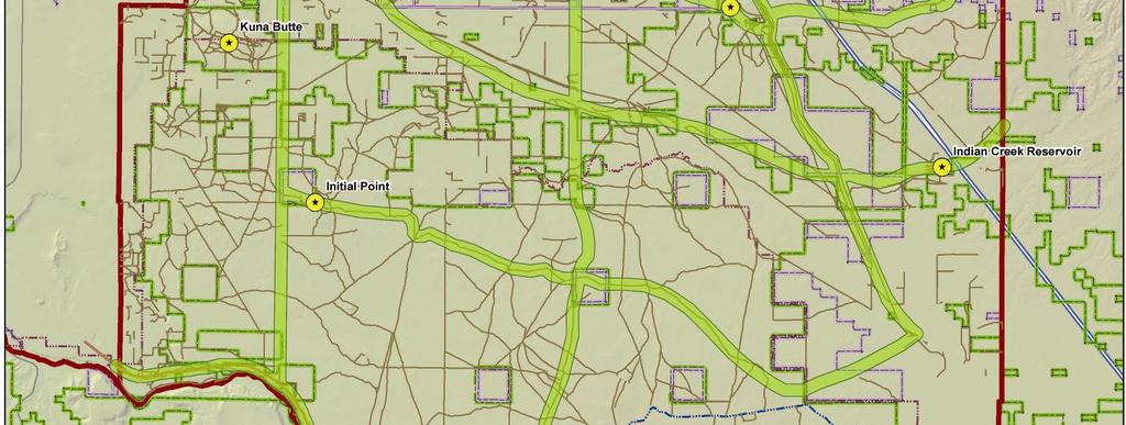

44 Figure 5-2: Conceptual County-Wide Trail System 33
3. VISION AND GOALS. Vision Statement. Goals, Objectives and Policies
 Vision Statement Queen Creek s interconnected network of parks, trails, open spaces and recreation opportunities provide safe and diverse activities and programs that sustain its unique, small town, equestrian
This page intentionally blank.
 This page intentionally blank. Parks, Recreation, and Open Space Chapter Relationship to Vision Vision Parks, Recreation and Open Space Chapter Concepts County Government. County government that is accountable
Support the implementation of Cape Coral's Comprehensive Plan. Protect and utilize the unique natural resources in the City.
 7.0 OVERVIEW - RECOMMENDATIONS Chapter 7 The preparation of the Cape Coral Parks and Recreation Master Plan spanned a period of approximately 12 months. Plan preparation included the input of a wide range
Chapter 5: Recreation
 Chapter 5: Recreation Introduction and Setting Recreational opportunities within Nevada County are varied, ranging from public parks with intensively used active recreational facilities, to vast tracts
Ada SWCD (Boise, Idaho) Partnership Outreach Strategy. NACD Urban & Community RPG Webinar September 20, 2012 Scott Koberg - Ada SWCD Manager
 Partnership Outreach Strategy. NACD Urban & Community RPG Webinar September 20, 2012 Scott Koberg - Ada SWCD Manager") Locally Led in Developing Areas: Ada SWCD (Boise, Idaho) Partnership Outreach Strategy NACD Urban & Community RPG Webinar September 20, 2012 Scott Koberg - Ada SWCD Manager Survive or Thrive? You can t
Locally Led in Developing Areas: Ada SWCD (Boise, Idaho) Partnership Outreach Strategy NACD Urban & Community RPG Webinar September 20, 2012 Scott Koberg - Ada SWCD Manager Survive or Thrive? You can t
Parks, Trails, and Open space Element
 Parks, Trails, and Open space Element Parks, Trails, and Open Space element Parks, Recreation, and Open Space are important components of the quality of life desired by the residents of Elk Grove. This
RECREATION, OPEN SPACE AND GREENWAYS ELEMENT GOALS, OBJECTIVES, AND POLICIES
 RECREATION, OPEN SPACE AND GREENWAYS ELEMENT GOALS, OBJECTIVES, AND POLICIES GOAL R-1: DEVELOP A RECREATION, OPEN SPACE AND GREENWAYS SYSTEM AS AN INTEGRAL COMPONENT OF AN OVERALL, COUNTY-WIDE ECONOMIC
Provide and maintain sufficient public parks, recreation facilities, and open space to meet the recreational needs of County residents and visitors.
 (ROS) Goal Provide and maintain sufficient public parks, recreation facilities, and open space to meet the recreational needs of County residents and visitors. OBJECTIVE ROS.01 The County shall acquire,
Ten Mile Creek Planning Area
 PLANNING AREA POLICIES TEN MILE CREEK Ten Mile Creek Planning Area Location and Context The Ten Mile Creek Planning Area ( Ten Mile Creek area ) is located south of the current Boise AOCI, generally south
Arlington, Virginia is a worldclass
 EXECUTIVE S U M M A RY Arlington maintains a rich variety of stable neighborhoods, quality schools and enlightened land use policies, and received the Environmental Protection Agency s highest award for
RECREATION AND OPEN SPACE ELEMENT GOALS, OBJECTIVES, AND POLICIES
 RECREATION AND OPEN SPACE ELEMENT GOALS, OBJECTIVES, AND POLICIES Goal 7 To provide park facilities, recreation programs, and open space resources that are safe, adequate, and accessible to all City residents,
City of Mahtomedi Park System Plan Public Hearing Draft: September 13, 2006
 Chapter 6: IMPLEMENTATION INTRODUCTION Earlier chapters of this Plan analyzed existing conditions, identified park and recreation needs, and proposed park, trail, and open space recommendations. This chapter
Purpose of the Master Plan
 Purpose of the Master Plan 4 Master Plan Purpose The Master Plan is a policy framework for decisions that affect the physical, social and economic environment of the Town. The Parker 2035: Master Plan
The transportation system in a community is an
 7 TRANSPORTATION The transportation system in a community is an important factor contributing to the quality of life of the residents. Without a sound transportation system to bring both goods and patrons
Town of Peru Comprehensive Plan Executive Summary
 Town of Peru Comprehensive Plan Executive Communities that plan grow by choice, not by chance. A plan makes growth thoughtful, understandable, and predictable. A plan shows that a community is managing
Parks, Trails, and Open Space Element
 P arks, Recreation, and Open Space are important components of the quality of life desired by the residents of Elk Grove. This Element of the General Plan addresses the City s goals, policies, and actions
OPEN SPACE CHAPTER 7: OVERVIEW. Preserve open space to protect natural resources, enhance character and provide passive recreation opportunities
 CHAPTER 7: OPEN SPACE OVERVIEW Ridgefield has made tremendous progress permanently preserving areas of town as open space. Open space preservation can serve many important purposes, including: protect
Purpose of the Master Plan
 Purpose of the Master Plan 4 Master Plan Purpose The Master Plan is a policy framework for decisions that affect the physical, social and economic environment of the Town. The Parker 2035: Master Plan
The following principles guide the development of goals and strategies to protect and promote these amenities:
 OPEN SPACE/PARKS/TRAILS/RECREATION GOALS/STRATEGIES Cherry Hills Village is a living environment that offers low density development, open areas, public scenic vistas, public trails and public parks. This
I. STAFF POLICY RECOMMENDATIONS. The following RMP policy strategies are proposed by staff in support of a Scenic Resource Protection Program:
 Policy Consideration: Scenic Resource Protection Program Status: For Consideration by the Highlands Council at September 14, 2006 Work session Date: September 12, 2006 I. STAFF POLICY RECOMMENDATIONS The
SECTION FOUR: MISSION STATEMENT, GOALS & OBJECTIVES
 SECTION FOUR: MISSION STATEMENT, GOALS & OBJECTIVES Chapter Summary Chapter Ten: Mission Statement, Goals & Objectives To fulfill its mission, the Parks and Recreation Commission has identified four basic
City of Tacoma Planning and Development Services
 Agenda Item D-1 City of Tacoma Planning and Development Services To: Planning Commission From: Elliott Barnett, Planning Services Division Subject: Application #2014-08 Open Space Element Update Meeting
CHAPTER 12 IMPLEMENTATION
 CHAPTER 12 IMPLEMENTATION The 2010 Town of Denton Comprehensive Plan is intended to capture a vision of the future of Denton. As such, it provides a basis for a wide variety of public and private actions
CHAPTER 4 FUTURE LAND USE AND URBAN SERVICES DISTRICTS
 CHAPTER 4 FUTURE LAND USE AND URBAN SERVICES DISTRICTS Introduction This chapter discusses how Benzie County should grow and change in the future. A community can grow and change in many different ways.
Green Infrastructure Policies and Ordinances
 Green Infrastructure Policies and Ordinances October 23, 2013 By Karen Firehock, Green Infrastructure Center 2013 Georgia Urban Forest Council s 23 rd Annual Conference The mission of the nonprofit Green
CHAPTER 1 Introduction
 CHAPTER 1 Introduction From sea to summit, Lane County covers almost 4,800 square miles of diverse Oregon landscape. Stretching from the Pacific Ocean through the Coastal Range, the Willamette Valley to
TOWN OF BETHLEHEM OPEN SPACE CONSERVATION PLAN PUBLIC MEETING: OCTOBER 12, 2017
 TOWN OF BETHLEHEM OPEN SPACE CONSERVATION PLAN PUBLIC MEETING: OCTOBER 12, 2017 Welcome and Agenda 6:00 6:45: Open House, Part One 6:45 7:15: Presentation and Questions 7:15 8:00: Open House, Part Two
RESPONSES TO PUBLIC CONCERNS AND QUESTIONS
 RESPONSES TO PUBLIC CONCERNS AND QUESTIONS Stations and Summary Questions for Public Meeting #2 June 23, 2015 General Questions / Concerns: 1. Is there any way this development can raise revenue for the
CITY OF CHARLOTTESVILLE, VIRGINIA CITY COUNCIL AGENDA
 CITY OF CHARLOTTESVILLE, VIRGINIA CITY COUNCIL AGENDA Agenda Date: December 16, 2013 Action Required: Adoption of Resolution Presenter: Staff Contacts: Title: James E. Tolbert, AICP, Director of NDS James
WASHINGTON COUNTY OREGON
 WASHINGTON COUNTY OREGON LONG RANGE PLANNING DIVISION North Bethany Subarea Stream Corridors: Existing Regulations In Oregon, there is a distinct difference between the land use rules that apply in rural
Whitemarsh Township Greenway Plan
 Whitemarsh Township Greenway Plan Prepared for: Whitemarsh Township August 16, 2007 Table of Contents Table of Contents... i Introduction... 1 Study Area Setting... 2 Regional Setting... 2 Township Character...
ADOPTION OF THE REVISED OPEN SPACE AND CONSERVATION ELEMENT OF THE GENERAL PLAN
 TO: FROM: SUBJECT: Honorable Mayor and City Council Planning Department ADOPTION OF THE REVISED OPEN SPACE AND CONSERVATION ELEMENT OF THE GENERAL PLAN RECOMMENDATION: It is recommended that the City Council:
Office of Greenways & Trails Providing Statewide Leadership and Coordination. Southeast Greenways and Trails Summit October 1-3, 2017
 Office of Greenways & Trails Providing Statewide Leadership and Coordination Southeast Greenways and Trails Summit October 1-3, 2017 1 Office of Greenways and Trails The Office of Greenways and Trails
COLVER ROAD INDUSTRIAL CONCEPT PLAN
 COLVER ROAD INDUSTRIAL CONCEPT PLAN A CONCEPTUAL LAND USE AND TRANSPORTATION PLAN FOR TA-4 AN URBAN RESERVE AREA OF THE CITY TALENT City of Talent Adopted by City Council Resolution No., June, 2015 PART
TOWN OF SPRINGFIELD, NEW HAMPSHIRE
 TOWN OF SPRINGFIELD, NEW HAMPSHIRE NATURAL RESOURCES INVENTORY EXECUTIVE SUMMARY March 2008 Prepared by: Watershed to Wildlife, Inc. Natural Resource Consultants 42 Mill Street, Suite 3 Littleton, NH 03561
Preface. Erie. Scranton. Allentown. Pittsburgh. Harrisburg. Philadelphia
 The Southern Alleghenies Region The Southern Alleghenies Region spans the Laurel Highlands and Allegheny Front in the west across the Appalachians to the east. It is comprised of Blair, Bedford, Cambria,
Chapter 5: Natural Resources and Environment
 NATURAL RESOURCES AND ENVIRONMENT 5-1 5 Chapter 5: Natural Resources and Environment BACKGROUND AND INTENT Urban expansion represents the greatest risk for the future degradation of existing natural areas,
The City shall enhance and improve the accessibility of parks and recreational facilities while protecting their quality. by:
 GOALS, OBJECTIVES AND POLICIES GOAL 1: To provide open space and recreation as an essential element needed for the betterment of the City s character and quality of urban life. The City shall plan for
Minnesota Department of Natural Resource - Natural Resource Guidance Checklist Conserving Natural Resources through Density Bonuses
 Minnesota Department of Natural Resource - Natural Resource Guidance Checklist Conserving Natural Resources through Density Bonuses NRDB Why Use Density Bonuses & This Checklist Local units of government
Regional Context Statement
 Regional Context Statement REGIONAL CONTEXT STATEMENT 3. REGIONAL CONTEXT STATEMENT In 1995, the Provincial Government passed into law the Growth Strategies Act. The purpose of this provincial initiative
Working together to leverage limited Funds
 Working together to leverage limited Funds ARAPAHOE COUNTY OPEN SPACES 10 County Budget Conference September 20, 2013 The Power of Partnerships 2013 SORP Conference 5/23/2014 Why Talk About Open Space?
OPEN SPACE AND RECREATION
 OPEN SPACE AND RECREATION The Town celebrates and maintains the spectacular visual character of our Sonoran Desert setting and we value our open space, mountain views, washes, vegetation, and wildlife.
Yadkin River Greenway Feasibility Study Fact Sheet Village of Clemmons, Town of Lewisville, Town of Bermuda Run
 Fact Sheet Village of Clemmons, Town of Lewisville, Town of Bermuda Run Project Background The Yadkin River Greenway Feasibility Study is a joint project with the Village of Clemmons, the Town of Bermuda
EL DORADO COUNTY GENERAL PLAN PARKS AND RECREATION ELEMENT PRINCIPLE INTRODUCTION STATE AUTHORIZATION
 EL DORADO COUNTY GENERAL PLAN PARKS AND RECREATION ELEMENT PRINCIPLE The General Plan must identify the types of governmental services, including parks and recreation facilities, which are necessary to
The Rocky Mountain Arsenal and the Northeast Greenway Corridor Project:
 The Rocky Mountain Arsenal and the Northeast Greenway Corridor Project: Contamination to Collaboration Presented by Howard Kenison Overview of Presentation Rocky Mountain Arsenal Contamination Litigation,
Meridian. Pathways Master Plan 1. INTRODUCTION. Plan Overview
 Meridian Pathways Master Plan 1. INTRODUCTION Plan Overview Pathways offer numerous aesthetic and recreational opportunities, as well as commuter options for traveling to and from destinations in the city
Photo by Carlton Ward Jr. Executive Summary
 Photo by Carlton Ward Jr. Executive Summary The Cooperative Conservation Blueprint (Blueprint) is a multi-partner strategic conservation process developed by the Florida Fish and Wildlife Commission (FWC)
Chapter 10 IMPLEMENTATION RECOMMENDATIONS
 Chapter 10 IMPLEMENTATION RECOMMENDATIONS The recommended land use plan presented in the previous chapter provides a design for the attainment of the urban and rural development and open space preservation
DRAFT MAP AMENDMENT FLU 04-4
 DRAFT MAP AMENDMENT FLU 04-4 SW 24 TH AVENUE ROADWAY CORRIDOR The University of Florida participates with the Metropolitan Transportation Planning Organization (MTPO) in its responsibilities for the continuing,
Department of Community Development. Planning and Environmental Review Division Revised Notice of Preparation
 Department of Community Development Michael J. Penrose, Acting Director Divisions Building Permits & Inspection Code Enforcement County Engineering Economic Development & Marketing Planning & Environmental
1) Providing education, access to healthy foods, and economic support for the local food system
 Providing education, access to healthy foods, and economic support for the local food system") Page 1 of x s Policy Statement Community gardens should be created, where appropriate, within designated urban agriculture areas in neighborhood parks, as well as on tax-forfeited parcels that are acquired
Page 1 of x s Policy Statement Community gardens should be created, where appropriate, within designated urban agriculture areas in neighborhood parks, as well as on tax-forfeited parcels that are acquired
IMPLEMENTING SOMERSET COUNTY S INVESTMENT FRAMEWORK
 IMPLEMENTING SOMERSET COUNTY S INVESTMENT FRAMEWORK SMART CONSERVATION THROUGH SMART GROWTH NJ LAND CONSERVATION RALLY March 22, 2014 Laurette Kratina, PP, AICP, Supervising Planner Somerset County Planning
Lewisville Lake Master Plan Revision Public Information Meeting May 2 & 4, 2017
 Lewisville Lake Master Plan Revision Public Information Meeting May 2 & 4, 2017 Presented By Rob Jordan Lake Manager U.S. Army Corps of Engineers Fort Worth District US Army Corps of Engineers Purpose
Implementation Guide Comprehensive Plan City of Allen
 Implementation Guide 2030 Comprehensive Plan City of Allen DRAFT 2015 Implementation Guide Allen 2030 Comprehensive Plan INTRODUCTION The Comprehensive Plan serves as a guide for the growth and development
Canyon Lake Master Plan Revision Public Information Meeting March 18, 2016
 Canyon Lake Master Plan Revision Public Information Meeting March 18, 2016 Marcus Schimank Canyon Lake Manager Capital Regional Office U.S. Army Corps of Engineers Fort Worth District US Army Corps of
Objectives and Strategies for the Integration of Recreation, Parks and Open Space in Regional Plans
 BULLETIN 2 Objectives and Strategies for the Integration of Recreation, Parks and Open Space in Regional Plans TABLE OF CONTENTS Introduction 3 Land-use Framework Outcomes 1 4-8 Land-use Framework Outcomes
Ottawa County Parks, Recreation & Open Space Plan. February, 2006
 2006 Ottawa County Parks, Recreation & Open Space Plan February, 2006 TABLE OF CONTENTS ACKNOWLEDGMENTS.................................................... v PLAN ADOPTION..........................................................vi
National Association of Conservation Districts. Kris Hoellen Vice President, Sustainable Programs The Conservation Fund September 19, 2013
 National Association of Conservation Districts Kris Hoellen Vice President, Sustainable Programs The Conservation Fund September 19, 2013 Our Mission The Conservation Fund forges partnerships to conserve
{Best Practices. Summary of Tools, Strategies and Best Practices from 11 Michigan Case Study Communities
 Case Studies Michigan Coastal Community Working Waterfronts { Summary of Tools, Strategies and from 11 Michigan Case Study Communities Table of Contents Zoning...2 Community and Stakeholder Collaboration
G. RECREATION AND OPEN SPACE ELEMENT. The following summarizes the Recreation and Open Space Element:
 G. RECREATION AND OPEN SPACE ELEMENT The purpose of the Element is to provide the framework and direction for a comprehensive system of public and private sites for recreation, including, but not limited
METROPOLITAN COUNCIL 390 North Robert Street, St. Paul, MN Phone (651) ; TDD (651)
 ; TDD (651)") DATE: December 20, 2011 METROPOLITAN COUNCIL 390 North Robert Street, St. Paul, MN 55101 Phone (651) 602-1000; TDD (651) 291-0904 TO: Metropolitan Parks and Open Space Commission FROM: Tori Dupre, Senior
DATE: December 20, 2011 METROPOLITAN COUNCIL 390 North Robert Street, St. Paul, MN 55101 Phone (651) 602-1000; TDD (651) 291-0904 TO: Metropolitan Parks and Open Space Commission FROM: Tori Dupre, Senior
Chapter 13: Implementation Plan
 Implementation A. Introduction The Implementation Plan, in table form on the following pages, provides a summary of all the Action Items recommended in Chapters 2 through 12. The table also indicates which
Master Plan Objectives and Policies
 Master Plan Objectives and Policies Introduction This chapter identifies the Park issues and recommended policies established by this Master Plan. The issues were identified through meetings with staff,
Overview of Southwestern Pennsylvania Commission s (SPC) 2040 Long Range Transportation Plan (LRTP)
 2040 Long Range Transportation Plan (LRTP)") Overview of Southwestern Pennsylvania Commission s (SPC) 2040 Long Range Transportation Plan (LRTP) Presented to Pennsylvania Agency Coordination Meeting May 27, 2015 Doug Smith & Ryan Gordon 1 Southwestern
Overview of Southwestern Pennsylvania Commission s (SPC) 2040 Long Range Transportation Plan (LRTP) Presented to Pennsylvania Agency Coordination Meeting May 27, 2015 Doug Smith & Ryan Gordon 1 Southwestern
Riparian Buffer on the Bushkill Creek. Policies
 Riparian Buffer on the Bushkill Creek Riparian buffers provide numerous benefits to landowners and the community by protecting groundwater recharge areas, providing flood control, providing stormwater
Arkansas River Corridor
 Planning for Access Welcome to the Access Project. This project is a recreational planning effort in response to an interest by regional communities along the Arkansas River corridor. The project plan
Plan Overview. Manhattan Area 2035 Reflections and Progress. Chapter 1: Introduction. Background
 Plan Overview The Manhattan Urban Area Comprehensive Plan (the Comprehensive Plan) is a joint planning initiative of the City of Manhattan, Pottawatomie County, and Riley County. The 2014 Comprehensive
INTERGOVERNMENTAL COORDINATION ELEMENT
 Goals, Objectives and Policies COORDINATION ELEMENT GOAL 8.1.: ESTABLISH EFFECTIVE COORDINATION MEASURES AMONG ALL PERTINENT PUBLIC AND QUASI-PUBLIC ENTITIES SO TO BEST MAINTAIN PALM BEACH GARDENS' QUALITY
STEWARDSHIP OF LONG ISLAND SOUND S ECOLOGICAL AND RECREATIONAL RESOURCES
 STEWARDSHIP OF LONG ISLAND SOUND S ECOLOGICAL AND RECREATIONAL RESOURCES Robin Kriesberg, Save the Sound, Inc. Thomas Halavik, US Fish and Wildlife Service Coastal Program An Initiative to Identify, Protect
Parks and Open Space Preservation and Dedication. January 26, 2016 Fort Worth City Council Pre-Council Meeting Randle Harwood and Richard Zavala
 Parks and Open Space Preservation and Dedication January 26, 2016 Fort Worth City Council Pre-Council Meeting Randle Harwood and Richard Zavala Purpose How does the City of Fort Worth preserve and protect
INTEGRATING NATURAL RESOURCES INTO A DEVELOPMENT, PUBLIC AND PRIVATE ROLES
 INTEGRATING NATURAL RESOURCES INTO A DEVELOPMENT, PUBLIC AND PRIVATE ROLES Why? Integrating natural resources into a development can increase its market value, enhance the quality of life for those who
Call for Artists for: Design and Construction of Environmental Art Activation Story Mill Community Park, Bozeman, MT
 Call for Artists for: Design and Construction of Environmental Art Activation Story Mill Community Park, Bozeman, MT Seeking artists to design, fabricate and install art elements in the nature sanctuary
Draft Stillwater 2030 Comprehensive Plan- Goals and Policies
 Draft Stillwater 2030 Comprehensive Plan- Goals and Policies Instructions- Review each goal and policy and discuss with group any changes, deletions for additions to the list using your groups pen. Keep
Public Information Meeting
 Lavon Lake Master Plan Revision Public Information Meeting March 10, 2015 Presented By Michael Kinard Lake Manager U.S. Army Corps of Engineers Fort Worth District US Army Corps of Engineers Purpose of
Open Space and Farmland Preservation
 Vibrant. Green. Connected. Competitive. Open Space and Farmland Preservation Statement of Purpose The purpose of this section of the Plan is to encourage and support the preservation of open space areas
Chapter 5 Greenway Corridors
 Chapter 5 Greenway Corridors Corridor Identification and Prioritization The inventory and analysis phase identified and mapped resources that contribute to greenway development. Corridors were then designated
Sorted citizen input comments in review of Blount County plans July, August, and September 2007
 Sorted citizen input comments in review of Blount County plans July, August, and September 2007 The following presents sorted citizen input comments from three sessions held in July, August and September
WARM SPRINGS PARK MASTER PLAN
 TABLE OF CONTENTS page 1.0 Introduction and Overview 1 2.0 Information Gathering 2 3.0 Conceptual Alternative Development 8 4.0 Master Plan Development 14 5.0 Construction Cost Estimates 19 LIST OF FIGURES
Pittsfield Action Plan (West Branch of the Housatonic River)
") An initiative of the Massachusetts Executive Office of Energy and Environmental Affairs in partnership with the City of Pittsfield Pittsfield Action Plan (West Branch of the Housatonic River) The spring
An initiative of the Massachusetts Executive Office of Energy and Environmental Affairs in partnership with the City of Pittsfield Pittsfield Action Plan (West Branch of the Housatonic River) The spring
FAQ S about Restoration Planning FROM THE Department of Ecology WEBSITE:
 FAQ S about Restoration Planning FROM THE Department of Ecology WEBSITE: http://www.ecy.wa.gov/programs/sea/sma/st_guide/smp/restoration/qanda.html Notations in parentheses are staff notes directing you
Joe Pool Lake Master Plan Revision Public Information Meeting May 23, 2017
 Joe Pool Lake Master Plan Revision Public Information Meeting May 23, 2017 Presented By Jason Owen Lake Manager U.S. Army Corps of Engineers Fort Worth District US Army Corps of Engineers Purpose of this
INTRODUCTION PLANNING HISTORY
 INTRODUCTION The Upper Rock Creek Master Plan Area lies in the east central part of Montgomery County. The Master Plan Area is adjacent to the City of Rockville to the south, the Olney Planning Area to
Conservation Corridor Planning and Green Infrastructure Themes
 Conservation Corridor Planning and Green Infrastructure Themes Prepared by the Green Infrastructure Center Inc. and the Northern Virginia Regional Commission February 22, 2011 Brief Overview Project Background
Portage County Parks, Trails and Greenways Plan
 Portage County Parks, Trails and Greenways Plan Agenda for Local Planning Meeting Introductory Presentation Why we need a Plan Plan project goals and process Benefits Overview of local planning region
CITY OF LANGLEY OFFICIAL COMMUNITY PLAN BYLAW, 2005, NO APPENDIX II - REGIONAL CONTEXT MAP
 CITY OF LANGLEY OFFICIAL COMMUNITY PLAN BYLAW, 2005, NO. 2600 APPENDIX II - REGIONAL CONTEXT MAP ± Legend Agricultural Mixed Employment Industrial Conservation & Recreation Regional City Centre Urban Containment
Staff will be providing an overview of the project need, purpose and intent for consideration as part of the Amendment cycle.
 Agenda Item D-2 City of Tacoma Planning and Development Services To: Planning Commission From: Stephen Atkinson, Planning Services Division Subject: Open Space Corridors Project Meeting Date: March 1,
Washtenaw County Department of Planning & Environment
 Washtenaw County Department of Planning & Environment 9/12/2007 Trudy Feldkamp, Planning Commission Secretary 7887 Klager Rd. Saline, MI 48176 Re: General Development Plan for Saline Township Review Dear
6. RECREATION AND OPEN SPACE ELEMENT
 6. RECREATION AND OPEN SPACE Introduction This Recreation and Open Space Element includes Goals, Objectives and Policies (GOP) that apply to the main campus in Gainesville and the Lake Wauburg Recreation
ESSENTIAL PUBLIC FACILITIES
 ESSENTIAL PUBLIC FACILITIES PURPOSE This section contains guidelines and policies which outline a process and define a set of criteria to be used to identify sites for development of facilities classified
Chapter 9 Community Facilities & Services Plan. Introduction. Cooperative Efforts. Monitoring of Needs
 Chapter 9 Community Facilities & Services Plan Introduction The location of key community facilities such as water, sewer, schools, parks, and roads is important to the provision of the necessary services
Executive Summary Purpose of the Plan Defining Open Space and Greenways
 Executive Summary Bucks County possesses a vast array of open space resources including natural areas, parks, farmland and historic and cultural resources that contribute to a high quality of life valued
Parks, Open Space and Trails
 Introduction Parks have often been referred as the lungs of our cities, cleansing the air of pollutants and particulate matter. Parks are also gathering places for families and community. They offer spaces
6.0 Conclusions & Recommendations
 6.0 Conclusions & Recommendations 75 The research, public outreach and feasibility analysis completed for this study indicate that Trail Alternative #2 (South side of Doctors Creek) is the most comprehensive
Countywide Green Infrastructure
 Montgomery County s Countywide Green Infrastructure F U N C T I O N A L M A S T E R P L A N The Maryland National Capital Park and Planning Commission INFRASTRUCTURE An underlying base or foundation especially
City of Missoula and Missoula County Open Space Planning Open House
 City of Missoula and Missoula County Open Space Planning Open House FEBRUARY 6, 2018 The following slides contain the display board content from the open house. Please use boards to answer questions in
PSRC REVIEW REPORT & CERTIFICATION RECOMMENDATION
 PSRC REVIEW REPORT & CERTIFICATION RECOMMENDATION KITSAP COUNTY COUNTYWIDE PLANNING POLICIES July 2, 2012 BACKGROUND A major emphasis of the Washington State Growth Management Act (GMA) is the need to
This chapter describes the purpose of the Plan, introduces how the Plan is organized and provides contextual background for the Plan.
 Chapter 1: INTRODUCTION Purpose of a Comprehensive Plan The 2040 Comprehensive Plan establishes Medina s vision as a community and sets goals and objectives which guide future decisions and policies. The
Open Space Element. General Plan. County of Sacramento Community Planning and Development Department
 General Plan Open Space Element Adopted December 15, 1993 Amended November 9, 2011 County of Sacramento Community Planning and Development Department This Page blank. Table of Contents SECTION I... 1 OPEN
FOUR MILE RUN VALLEY WORKING GROUP AND CHARGE
 FOUR MILE RUN VALLEY WORKING GROUP AND CHARGE Adopted April 16, 2016 Amended July 19, 2016 Overview of Integrated Effort The overall goal of the Four Mile Run Valley (4MRV) initiative is to develop a comprehensive
GENERAL PLAN UPDATE ISSUES MEETING. January 21, 2010 City Hall Mitchell Room 6:00 pm 9:00 pm
 GENERAL PLAN UPDATE ISSUES MEETING January 21, 2010 City Hall Mitchell Room 6:00 pm 9:00 pm WELCOME! Introductory Comments Continued Review of Quality of Life Standards, Growth Management, Proposition