AGENDA ITEM NO. 8 CITY OF HAWTHORNE CITY COUNCIL AGENDA BILL. For the special meeting of: March 8, 2016 Originating Department: Planning
|
|
|
- Brianne Henry
- 5 years ago
- Views:
Transcription
1 AGENDA ITEM NO. 8 CITY OF HAWTHORNE CITY COUNCIL AGENDA BILL For the special meeting of: March 8, 2016 Originating Department: Planning Department Head: Gregg McClain City Manager: Arnold Shadbehr SUBJECT: Final Environmental Impact Report General Plan Amendment 2016GP01 Downtown Hawthorne Specific Plan 2016SP01 DIRECTOR S RECOMMENDED MOTIONS: 1. Approve Resolution No. 7788, Certifying Final Environmental Impact Report for the Downtown Hawthorne Specific Plan Project (SCH # ), making Findings of Facts pursuant to CEQA, adopting a Statement of Overriding Consideration, adopting a Mitigation Monitoring Program as per Planning Commission Resolution No. PC Approve Resolution 7789, adopting General Plan Amendment 2016GP Approve Resolution 7790, adopting the Downtown Hawthorne Specific Plan 2016SP01. FISCAL IMPACT: Adoption of the specific plan provides opportunity for development at mall and civic center sites, as well as other sites along Hawthorne Boulevard and Imperial Highway. These will result in increased permit fees and development impact fees, but the extent of the increase will depend on the extent of construction activity. In the long range, new commercial developments will generate a net increase in sales tax revenue and all developments will generate additional property tax revenues. Hotels built pursuant to the plan will generate new transient occupancy tax revenues. NOTICING PROCEDURES: Advertising and notification of the Public Hearing was conducted in compliance with Title 17, Chapter of the HMC. 1
2 REPORT: What is the Downtown Hawthorne Specific Plan? The Downtown Hawthorne Specific Plan encapsulates the community s vision to once again make Hawthorne Boulevard the city s economic, civic and cultural Downtown with a healthy mix of retail, office, hotel, dining, entertainment, employment, housing, civic and public spaces. It builds on the area s rich history and outlines a series of goals, strategies, projects and implementation actions that will bring positive change. It proposes bold transformative projects, as well as tactical quick wins that can be accomplished cost-effectively and in the near term. The plan sets forth a comprehensive, holistic approach, weaving together a nuanced set of strategies that collectively will foster a prosperous, connected, healthy, attractive and inclusive Downtown. California and the nation are moving out of the Great Recession and as a result, jobs and investments are beginning to trickle back into Hawthorne and the South Bay region. In recent years the City has made significant infrastructure improvements in Downtown. In addition, companies such as SpaceX and Tesla have expanded operations and employment within the city. The Downtown Hawthorne Specific Plan establishes a blueprint for how the city center will look, feel and function in the future. Informed by the collective vision of residents, workers, merchants and property owners, the plan advocates for a new urban form that is compact and less reliant on the private automobile. This will result in a Downtown where motorists, pedestrians, bicyclists and transit users have a variety of transportation options to reach mixed-use projects, employment and commercial centers, and housing. Where parks, plazas and civic destinations frame key gathering spaces for the community. And where major employers provide higher wage, professional jobs for local workers. Overview of the Plan The Downtown Hawthorne Specific Plan is a strategic, action-oriented document that presents a clear vision followed by specific strategies and actions necessary to achieve positive change in the coming years. It provides a range of short- to long-term and low- to high-cost implementation actions that will be carried out by the City of Hawthorne, partner public agencies, and the broader community. Each specific action reflects the community s vision, is intended to be realistic and achievable, and is based on sound policy for future decisionmaking. Each chapter helps tell the story of Downtown Hawthorne and how it will become an even better place in the years ahead. The Specific Plan consists of the following chapters: 2
3 Chapter 2: Vision Framework This chapter establishes the high-level vision for Downtown Hawthorne s future, including several important plan goals. It introduces 5 Vision Elements, which are supported by specific Plan Strategies and Transformative Projects. Chapter 3: Plan Strategies This chapter expands upon the Vision Elements and includes 17 Plan Strategies that are key to implementing the vision. Each Plan Strategy includes a goal statement and summary of why it is important, followed by specific policies and strategies for achieving the goal. Chapter 4: Transformative Projects This chapter includes 4 Transformative Projects that are key to the future evolution of Downtown Hawthorne. These projects represent key sites within Downtown where significant public and private investment will be focused to create catalytic changes, including the Hawthorne Mall and Civic Center. Chapter 5: Implementation This chapter outlines the major actions and ongoing commitments required to implement the plan and realize the vision for Downtown Hawthorne. This includes diagrams identifying future land use, mobility and infrastructure changes and improvements. It also includes a detailed Implementation Action Plan. Why does Hawthorne need this specific plan? Hawthorne sits, at this moment in its history, at a key juncture. After decades of pursuing the same strategies, Hawthorne appears to have stood in place while surrounding communities have taken off. Lawndale, our neighbor to the south, has transformed from the once derided wannabe of the South Bay to a thriving city with evident positive change to the commercial corridor along Hawthorne Boulevard. Gardena, our neighbor to the east, once plagued by stagnation is showing strong growth lead by positive and progressive economic and housing policies. El Segundo, our neighbor to the west is building office towers so fast it effectively eliminates that option for Hawthorne. Redondo Beach, our neighbor to the southwest has recently built two new hotels on our border that are competing for LAX business. Inglewood, more than any other city in the vicinity, is about to soar. In the past few years Inglewood has begun to transform Hollywood Park and developed many transit-related districts associated with Metro s rail expansion efforts. They successfully attracted an NFL team and a huge entertainment complex/stadium are being built now. Even Lennox, our unincorporated neighbor to the north, is benefitting finally by its proximity to Inglewood and LAX. Hawthorne, on the other hand, aside from public works improvements, has not seen significant economic progress manifest since Space X and Tesla moved in a decade ago. Our policies for the past few decades have, perhaps, prevented economic backsliding, but when every city around is marching forward, standing in place is falling behind. It is time to stop worrying about small matters and to shift focus to policies that promote responsible economic development and positive growth. The old policies of the past have contributed to a growing sentiment that Hawthorne is not what it used to be, not what it can be, and not living up to the potential that is so evident. 3
4 Approval of the DHSP opens the way for the Hawthorne Plaza Mall to be demolished and replaced with a vibrant new economic engine to drive other growth. The project envisions a mixed use project on the 26 acre site consisting of approximately 173,000 square feet of retail and restaurants, another 230,000 square feet of retail, approximately 450,000 of flex space, and 608 condominium units, of which approximately half will be reserved for seniors and the rest will be luxury market rate units. Approval of the DHSP also paves the way for the development of the parking lot and former police station south of City Hall. Plans are to build a new 300-room hotel and restaurant complex. The South Bay Ford site on Hawthorne Boulevard was once approved for a 155-unit mixed use project. Due to timing and the economic troubles of 2008, the project was not built and eventually the tentative map expired. The DHSP would overwrite the old specific plan and permit a project of similar, but slightly lower, density. One of the most significant changes that would be triggered by the DHSP is rezoning of the area near the intersection of Hawthorne Boulevard and Imperial Highway into a commercial zone that promotes the building of upper-end hotels and restaurants. These would be poised to capture both NFL and LAX traffic. Although this change can be done without he DHSP, it would require a new EIR and would then be too late as other cities will have filled the void and built hotels. The largest change will come in a new commercial zone designed to facilitate mixed use. Mixed use is a very important tool for stimulating not only new construction, but continued long term economic viability. Mixed use is also the best way to promote sustainability, walkability, and alternative transportation, such as bicycles. All over the country and all over California, cities are encouraging mixed use developments and seeing many positive benefits. Large-scale commercial only developments are not being built anymore. ATTACHMENTS: Draft Resolution No Draft Resolution No Draft Resolution No Planning Commission Resolution PC Planning Commission Resolution PC Planning Commission Resolution PC
5 RESOLUTION NO A RESOLUTION OF THE CITY COUNCIL OF THE CITY OF HAWTHORNE, CALIFORNIA CERTIFYING THE FINAL ENVIRONMENTAL IMPACT REPORT FOR THE DOWNTOWN HAWTHORNE SPECIFIC PLAN (SCH # ) FOR PURPOSES OF TAKING ACTION ON GENERAL PLAN AMENDMENT 2016GP01 AND ADOPTION OF THE DOWNTOWN HAWTHORNE SPECIFIC PLAN, MAKING FINDINGS OF FACT PURSUANT TO THE CALIFORNIA ENVIRONMENTAL QUALITY ACT, ADOPTING A STATEMENT OF OVERRIDING CONSIDERATIONS, AND ADOPTING A MITIGATION MONITORING PROGRAM and WHEREAS, the City of Hawthorne seeks to promote economic development generally; WHEREAS, the City s economy suffered tremendously during the recession that began in 2008; and WHEREAS, the City Council and the Planning Department sought ways to stimulate responsible economic development within the city; and WHEREAS, in January of 2012, the Planning Department asked for authorization from the City Council to apply to the Strategic Growth Council (SGC) for a sustainable communities planning grant, which is designed to promote sustainable community planning and natural resource conservation through the adoption of an implementation of various plans, infrastructure improvements, and conservation efforts; and WHEREAS, the Planning Department made an application to the SGC and on May 24, 2012 was granted $277,000 for the project known as the Downtown Hawthorne Specific Plan (DHSP); and WHEREAS, the City Council entered into an grant agreement with the SGC in January of 2013, and the Planning Department prepared and released a Request for Proposals (RFP) to solicit proposals from qualified consulting firms to prepare the specific plan; and WHEREAS, the specific plan covers a large portion of the central part of the city (See Exhibit A) from the 105 Freeway on the north to Rosecrans Avenue on the south; covering the area between Inglewood Avenue and Prairie Avenue north of 118th Street, excluding the 8-acre former Robert F. Kennedy Hospital site; Ramona Avenue to Freeman Avenue between 118th Street and El Segundo Boulevard; and Ramona Avenue to midway between Washington Avenue and Jefferson Avenue south of El Segundo Boulevard; and WHEREAS, the DHSP originally intended to replace two existing specific plans of the City, namely Prestige Villas Specific Plan and Primavera Courts Specific Plan, the Prestige Villas Specific Plan was determined by its owners to still be viable and was therefore carved out of 1
6 the DHSP, but he Primavera Courts Specific Plan was not acted upon by its owner and the final map expired, so the DHSP will eliminate and replace that plan; and WHEREAS, ten qualified responses to the RFP were received and each consulting team was interviewed by a panel composed of Planning Department staff and certain key department directors within the City, culminating in the decision to select the firm MIG to prepare the specific plan; and WHEREAS, MIG and the Planning Department conducted a series of public outreach meetings and workshops that informed the development of the plan over the course of three years; and WHEREAS, the DHSP identifies four transformative projects within the plan area, which are the former Hawthorne Plaza Mall, the area known as the Civic Center located south of City Hall, the South Bay Ford site on Hawthorne Boulevard, and the property west of St. Joseph s church, each of which are identified for their potential to activate the plan area and instigate the responsible economic and/or social development of the city; and WHEREAS, the specific plan also identifies the need for two new zoning classifications, one to promote hotel and restaurant development and on that will permit mixed use projects; and WHEREAS, The SGC did not provide funding for analysis required under the California Environmental Quality Act (CEQA) in this round of grants; and WHEREAS, due to budgetary limitations, the start of CEQA analysis was delayed by approximately two years; and WHEREAS, two qualified firms bid to prepare the Environmental Impact Report (EIR) for the specific plan; and WHEREAS, JWA Urban Consultants was selected by the Planning Department to prepare the EIR and a contract was entered into with the City Council in May, 2014; and WHEREAS, a Draft Environmental Impact Report (DEIR) under CEQA, State Clearinghouse No , was prepared for the DHSP Project and was transmitted to the State Clearinghouse and circulated for public review during a public comment period from December 22, 2015 through February 4, A Public Hearing was held on the DEIR on January 25, Comments were received during that period and written responses were prepared and sent to all commentators. Those comments and responses have been included in the Final Environmental Impact Report (FEIR). These documents together comprise the FEIR, which is hereinafter referred to as the FEIR or EIR and is attached as Exhibit B; and WHEREAS, on February 17, 2016, the Planning Commission held a duly noticed public hearing and after taking additional testimony and receiving additional documentation, closed 2
7 the hearing. The Planning Commission passed a resolution recommending that the City Council adopt Resolution 7788 certifying the Environmental Impact Report. WHEREAS, the City Council held a duly noticed public hearing on March 8, 2016, on the DEIR, at which time public comments were received by the Council; and WHEREAS, evidence was heard and presented from all persons in favor of the approval of the DEIR, from all persons opposed, and from members of the City staff; and the City Council heard and received all of said evidence, testimony and statements and is fully informed. NOW THEREFORE, the City Council of the City of Hawthorne does hereby find, determine and order as follows: Section 1. true and correct. The City Council finds that all of the facts recitals of this Resolution are Section 2. The City Council is the decision-making body for certifying the FEIR. For purposes of taking action, the City Council reaffirms that it has received and reviewed the FEIR for the Downtown Hawthorne Specific Plan Project, including the comments to the DEIR, the responses to those comments, and the oral and written testimony received thereon during the hearing prior to any action on the Project. Based on that review, along with a review of all evidence in the record, and for purposes of taking action on the applications listed in this Section 2, the City Council hereby certifies that the FEIR was completed pursuant to the California Environmental Quality Act, Public Resources Code 21000, et seq. (CEQA), and the State Guidelines for Implementation of CEQA, 14 California Code of Regulations 15000, et seq. (the Guidelines) and that it adequately addresses the impacts and provides for appropriate mitigation measures related to the specific plan and this General Plan Amendment necessary to carry out the Project. Section 3. The City Council finds, based on the FEIR, additional public comments, the written and oral staff report, and the entire record before it, that the Project will not cause significant environmental impacts except with respect to level of service at intersections throughout the plan area and surrounding areas, operations-related air pollutants, cumulative air quality impacts and consistency with regional air quality plans, greenhouse gas emissions, short-term demolition and construction noise, traffic noise, long-term operational noise, shortterm vibrations, hazardous materials and construction activities, rail safety, light and glare, shade and shadows, impacts on parks and recreation, and water supply. With respect to all of these potentially significant impacted areas and resources, the FEIR identifies feasible mitigation measures for each impact that reduce the level of impact to less than significant except for level of service at several intersections in the vicinity, operations-related air pollutants, cumulative air quality impacts and consistency with regional air quality plans, and water supply, as identified in the FEIR. Section 4. In response to each significant impact identified in the FEIR, and listed in Section 3 of this Resolution, changes or alterations are hereby required in, or incorporated into 3
8 the Project, which avoid or substantially lessen the impacts identified. The mitigation measures set forth in the Mitigation Monitoring Program, attached hereto as Exhibit C avoid or substantially lessen the potential significant impacts of the Project. The Planning Commission finds that the mitigation measures and Mitigation Monitoring Program as set forth in Exhibit C will avoid or mitigate all significant environmental effects of the Project that can feasibly be avoided or mitigated, but that even with those mitigation measures, significant impacts will occur with respect to cumulative air quality impacts from vehicular emissions, short-term project-specific and cumulative air quality and noise impacts from construction of individual facilities and improvements, and project-specific and cumulative contributions to solid and hazardous waste disposal at regional landfill facilities, as well as level of service at intersections where it is not feasible to implement physical changes to mitigate traffic impacts, as identified in the FEIR. Section 5. The City Council finds that the FEIR describes a reasonable range of alternatives to the Project that might fulfill the basic objectives of the Project. These alternatives include the required No Project alternative, a Mixed-Use/Housing Emphasis Alternative, and a Commercial Expansion Alternative. The alternatives identified in the FEIR are not feasible because they would not achieve the basic objectives of the Project or would do so only to a much lesser degree, and therefore leave unaddressed significant economic and sustainability goals the Project was designed to achieve, and are thus infeasible. Accordingly, and for the reasons set forth herein, the Planning Commission finds that each of the alternatives is determined to be infeasible. Section 6. The City Council finds that the following substantial benefits will occur as a result of the Project: (a) effectively promoting responsible economic development in the downtown area; (b) establishing a vision for future growth and development; (c) promoting long-term viable development that provides employment to compensate for past employment losses in the City; (d) maximizing revenues to offset City costs incurred in providing municipal services to the project area; (e) stimulate the development of new job-creating employment centers at identified transformative project sites; (f) promotion of new open space and recreation facilities in the project area; (g) foster the development of hotels and restaurants; and (h) preserve the heritage and history of Hawthorne. Section 7. The City Council finds, after balancing the unavoidable and irreversible environmental impacts of the Project with the benefits of the Project as described in Section 6 of this Resolution, that to the extent that adverse and potentially adverse impacts of the Project have not been mitigated to a level of less than significant, that the specific economic, social, legal, environmental and technological or other benefits of the Project, as described in Section 6, outweigh the significant and irreversible impacts to the environment. Therefore, due to overriding benefits of the Project and because the alternatives identified in the FEIR are not feasible, as discussed in Section 5 above, the Planning Commission hereby finds that any unavoidable impacts of the Project, including the mitigated but unavoidable cumulative air quality impacts from vehicular emissions, short-term project-specific and cumulative air quality and noise impacts from construction of individual facilities and improvements, and project- 4
9 specific and cumulative contributions to solid and hazardous waste disposal at regional landfill facilities, as well as level of service at intersections where it is not feasible to implement physical changes to mitigate traffic impacts, as identified in the FEIR, are acceptable. This determination shall constitute a statement of overriding considerations within the meaning of CEQA and is based on the benefits of the Project identified in the FEIR, the record of proceedings, and Section 6 of this Resolution. The Planning Commission further finds that each overriding benefit is severable from any other consideration should one or more consideration be shown or determined to be legally insufficient for any reason. Section 8. The City Council further finds that the Mitigation Monitoring Program has been completed in compliance with CEQA. The Planning Commission hereby recommends that the City Council adopt each of the mitigation measures set forth in the FEIR and incorporate those measures into the Project. The Planning Commission also recommends that the City Council adopt the Mitigation Monitoring Program attached hereto as Exhibit C and incorporated herein by reference. The Mitigation Monitoring Program will be used to monitor compliance with the mitigation measures and conditions that have been adopted or made a condition of Project approval. Section 9. The documents and other materials that constitute the record of the proceedings upon which the City Council makes its determination, which include, but are not limited to, the staff reports for the Project, as well as all of the materials that comprise and support the FEIR and all of the materials that support the staff reports for the Project, are located in the office of the Planning Director of the City of Hawthorne, at 4455 West 126th Street, Hawthorne, California The custodian of these documents is the Director of Planning of the City of Hawthorne. Section 10. Based on the recitals and findings contained in this Resolution and all evidence in the record, the City Council hereby certifies the Environmental Impact Report for the Downtown Hawthorne Specific Plan. Section 11. The City Clerk shall certify to the passage and this Resolution. 5
10 PASSED, APPROVED, and ADOPTED this 8th day of March, ATTEST: ALEX VARGAS, MAYOR City of Hawthorne, California NORBERT HUBER, CITY CLERK City of Hawthorne, California APPROVED AS TO FORM: RUSSELL MIYAHIRA, CITY ATTORNEY City of Hawthorne, California 6

11 EXHIBIT A Map of the Downtown Hawthorne Specific Plan Area 7
12 EXHIBIT B FINAL ENVIRONMENTAL IMPACT REPORT 8
13 EXHIBIT C MITIGATION MONITORING PROGRAM
14 RESOLUTION NO A RESOLUTION OF THE CITY COUNCIL OF THE CITY OF HAWTHORNE, CALIFORNIA, AMENDING THE TEXT OF THE LAND USE ELEMENT OF THE GENERAL PLAN RELATED TO AND INCORPORATING THE DOWNTOWN HAWTHORNE SPECIFIC PLAN AND UPDATING DATA AND REORGANIZING THE ELEMNET IN GENERAL WHEREAS, Government Code Section gives to cities the ability to adopt specific plans that implement the goals and policies of the General Plan; and WHEREAS, the City of Hawthorne Land Use Element of the General Plan was adopted in 1990 and most recently updated in 2013; and WHEREAS, the City of Hawthorne intends to adopt the Downtown Hawthorne Specific Plan (DHSP); and WHEREAS, the Downtown Hawthorne Specific Plan advances the existing policies of the General Plan within the area designated, and specific ally with respect to the following policies: Land Use Element POLICY 1.2: The Hawthorne Boulevard Corridor shall be reviewed to determine the most feasible program for commercial revitalization. POLICY 1.4: The City shall support and encourage the rehabilitation or renovation of existing buildings or structures or the conversion of obsolete and/or chronically vacant storefronts from their original or most recent use to a new compatible, economically viable, and sustainable use. POLICY 2.3: A specific plan for the Hawthorne Boulevard corridor shall be prepared. POLICY 2.7: Encourage the development of unified commercial centers and neighborhood commercial centers rather than the continued development of "strip commercial." POLICY 3.1: The promotion of businesses that generate positive economic benefits to the community, including generating tax revenue, job creation and enhancing the quality of life for residents and visitors shall be encouraged and assisted. POLICY 3.2: The design of future developments projects shall consider the economic benefits and detriments that the project will provide. POLICY 3.3: Development standards that encourage positive economic outcomes shall be adopted.
15 POLICY 3.4: Any tools available to attract new businesses that create quality jobs, generate revenue, or enhance the quality of life for residents, those employed with the city and visitors to the city shall be considered. POLICY 3.5: Revitalization of declining commercial and industrial areas through new development, rehabilitation and other means that may be available shall be considered and, if deemed advantageous, implemented. POLICY 3.6: Land use regulations shall be regularly evaluated and updated to facilitate the attraction of high technology industries which will enhance the local economy and support Hawthorne's image as a aerospace research and development hub. POLICY 3.7: The retention and expansion of small businesses shall be encouraged through changes in zoning regulations. Housing Element: POLICY 2.3: Expand housing options through high-density multi-family and mixed use developments in targeted areas. POLICY 2.7: Promote homeownership to increase neighborhood stability and provide increased housing choice. POLICY 2.8: Emphasize ownership housing as a preferred tenure form for new housing to achieve a tenure distribution that is consistent with national and regional trends. POLICY 3.3: Encourage the use of special development zones and other mechanisms to allow more flexibility in housing developments. POLICY 4.1: Implement land use policies that allow for a range of residential densities. Circulation Element POLICY 1.8: The City shall encourage the maintenance and improvement, where appropriate, of the safe and convenient bicycle and pedestrian movement through the City. POLICY 1.12: The City shall examine the feasibility of designating streets for one-way traffic flow. POLICY 1.13: The City shall review and consider the designation of additional bike-lanes where appropriate. POLICY 1.26: The City is encouraged to design arterial streets as complete streets, balancing the needs, safety, and use of public right-of-way for all users of all abilities.
16 POLICY 1.27: The City shall identify bicycle corridors within City limits and adjacent municipalities in order to integrate into the regional bicycle plan and connect resident to activity centers. POLICY 1.29: The City shall support the retrofitting of existing arterials to be safe, accessible, and comfortable transportation corridors to meet the needs of all modes of transportation, prioritizing resurfaced and rebuilt streets for the first retrofits. Economic Development Element POLICY 1.1: The promotion of businesses that generate positive economic benefits to the community, including generating tax revenue, job creation and enhancing the quality of life for residents and visitors shall be encouraged and assisted. POLICY 1.2: Any tools available to attract new businesses that create quality jobs, generate revenue, or enhance the quality of life for residents, those employed with the city and visitors to the city shall be considered. POLICY 1.3: Revitalization of declining commercial and industrial areas through new development, rehabilitation and other means that may be available shall be considered and, if deemed advantageous, implemented. Policy 8.2: To enhance the quality of life in the City, which is an important marketing asset for business attraction, the City shall develop a plan to create publicly accessible and useable open space throughout the city, but most especially in areas where open space is scarce or non-existent. Policy 8.4: The City shall continue to develop special districts and use these to guide development and economic activity to better the whole community. These districts shall include, but not be limited to, zones, overlay zones, specific plans, districts (such as for business improvement), and the like. Open Space Element POLICY 1.14: The City shall create a specific plan for Hawthorne Boulevard streetscape improvements, and a green streets/corridors plan. Conservation Element: POLICY 2.2: The City shall encourage alternate modes of transportation including vanpooling, carpooling, bicycling and mass transit use. POLICY 2.3: The City shall encourage development plans that are less automobile oriented.
17 POLICY 2.4: The City shall promote an integration of land uses so that alternative modes of transportation such as walking and bicycling, can be utilized for movement between uses.; and WHEREAS, the proposed amendment to the Land Use Element identifies the specific plan and makes appropriate accommodations and updates to the element; and WHEREAS, the proposed amendment to the Land Use Element also reorganizes the tables and figures and makes other organizational improvements; and WHEREAS, the proposed amendment also corrects a longstanding inconsistency between the General Plan and zoning by reducing the maximum density of the Maximum Density Residential District to 30 units per acre; and WHEREAS, the above mentioned reduction in density will not have an impact, positive or negative, on the permitted density of developments within the city except that density bonus calculations will be based on the reduced density and thus bring the density bonuses offered to developers in line with the densities that are intended by the density bonus laws (Government Code et seq.), rather than far exceeding that density, as is currently the case; and WHEREAS, the City Council does find and determine that General Plan Amendment No. 2016GP01, as described above, should be approved, and that the evidence presented shows that all of the necessary conditions exist, based upon the findings approved and adopted by the Planning Commission in its Resolution No. PC , and that the evidence presented substantiates the need for an amendment to the Hawthorne General Plan and that the proposed amendment maintains the internal consistency of the General Plan as the proposed modifications to the Land Use Element of the General Plan, as shown in Exhibit A attached to this Resolution, are consistent with the goals and policies set forth in the General Plan; and WHEREAS, pursuant to Government Code Section , the City prepared a draft of the amendments to the Land Use Element as General Plan Amendment 2016GP01; and WHEREAS, City staff processed the proposed amendments to the Land Use Element in accordance with the procedures specified in Chapter 17.06, Title 17 of the Hawthorne Municipal Code and state law; and WHEREAS, the Planning Commission held a duly noticed public hearing on February 17, 2016, on the draft amendments to the Land Use Element, at which time public comments were received by the Commission. The Planning Commission passed a resolution recommending that the City Council adopt the amendments to the Land Use Element; and WHEREAS, the City Council held a duly noticed public hearing on March 8, 2016, on the draft amendments to the Land Use Element, at which time public comments were received by the Council; and
18 WHEREAS, evidence was heard and presented from all persons in favor of the approval of the Land Use Element, from all persons opposed, and from members of the City staff; and the City Council heard and received all of said evidence, testimony and statements and is fully informed in the application; NOW THEREFORE, the City Council of the City of Hawthorne does hereby find, determine and order as follows: Section 1. true and correct. The City Council finds that all of the facts recitals of this Resolution are Section 2. The City Council is the decision-making body for General Plan Amendment 2016GP01. For purposes of taking action on this Applications, the City Council reaffirms that it has received and reviewed the FEIR for the Downtown Hawthorne Specific Plan Project, including the comments to the DEIR, the responses to those comments, and the oral and written testimony received thereon during the hearing prior to any action on the Project. Based on that review, along with a review of all evidence in the record, and for purposes of taking action on the applications listed in this Section 2, the City Council hereby certifies that the FEIR was completed pursuant to the California Environmental Quality Act, Public Resources Code 21000, et seq. (CEQA), and the State Guidelines for Implementation of CEQA, 14 California Code of Regulations 15000, et seq. (the Guidelines) and that it adequately addresses the impacts and provides for appropriate mitigation measures related to the specific plan and this General Plan Amendment necessary to carry out the Project. Section 3. The City Council finds, based on the FEIR, additional public comments, the written and oral staff report, and the entire record before it, that the Project will not cause significant environmental impacts except with respect to level of service at intersections throughout the plan area and surrounding areas, operations-related air pollutants, cumulative air quality impacts and consistency with regional air quality plans, greenhouse gas emissions, short-term demolition and construction noise, traffic noise, long-term operational noise, shortterm vibrations, hazardous materials and construction activities, rail safety, light and glare, shade and shadows, impacts on parks and recreation, and water supply. With respect to all of these potentially significant impacted areas and resources, the FEIR identifies feasible mitigation measures for each impact that reduce the level of impact to less than significant except for level of service at several intersections in the vicinity, operations-related air pollutants, cumulative air quality impacts and consistency with regional air quality plans, and water supply, as identified in the FEIR. Section 4. In response to each significant impact identified in the FEIR, and listed in Section 3 of this Resolution, changes or alterations are hereby required in, or incorporated into the Project, which avoid or substantially lessen the impacts identified. The mitigation measures set forth in the Mitigation Monitoring Program, attached hereto as Exhibit C avoid or substantially lessen the potential significant impacts of the Project. The Planning Commission finds that the mitigation measures and Mitigation Monitoring Program as set forth in Exhibit C will avoid or mitigate all significant environmental effects of the Project that can feasibly be
19 avoided or mitigated, but that even with those mitigation measures, significant impacts will occur with respect to cumulative air quality impacts from vehicular emissions, short-term project-specific and cumulative air quality and noise impacts from construction of individual facilities and improvements, and project-specific and cumulative contributions to solid and hazardous waste disposal at regional landfill facilities, as well as level of service at intersections where it is not feasible to implement physical changes to mitigate traffic impacts, as identified in the FEIR. Section 5. The City Council finds that the FEIR describes a reasonable range of alternatives to the Project that might fulfill the basic objectives of the Project. These alternatives include the required No Project alternative, a Mixed-Use/Housing Emphasis Alternative, and a Commercial Expansion Alternative. The alternatives identified in the FEIR are not feasible because they would not achieve the basic objectives of the Project or would do so only to a much lesser degree, and therefore leave unaddressed significant economic and sustainability goals the Project was designed to achieve, and are thus infeasible. Accordingly, and for the reasons set forth herein, the Planning Commission finds that each of the alternatives is determined to be infeasible. Section 6. The City Council finds that the following substantial benefits will occur as a result of the Project: (a) effectively promoting responsible economic development in the downtown area; (b) establishing a vision for future growth and development; (c) promoting long-term viable development that provides employment to compensate for past employment losses in the City; (d) maximizing revenues to offset City costs incurred in providing municipal services to the project area; (e) stimulate the development of new job-creating employment centers at identified transformative project sites; (f) promotion of new open space and recreation facilities in the project area; (g) foster the development of hotels and restaurants; and (h) preserve the heritage and history of Hawthorne. Section 7. The City Council finds, after balancing the unavoidable and irreversible environmental impacts of the Project with the benefits of the Project as described in Section 6 of this Resolution, that to the extent that adverse and potentially adverse impacts of the Project have not been mitigated to a level of less than significant, that the specific economic, social, legal, environmental and technological or other benefits of the Project, as described in Section 6, outweigh the significant and irreversible impacts to the environment. Therefore, due to overriding benefits of the Project and because the alternatives identified in the FEIR are not feasible, as discussed in Section 5 above, the Planning Commission hereby finds that any unavoidable impacts of the Project, including the mitigated but unavoidable cumulative air quality impacts from vehicular emissions, short-term project-specific and cumulative air quality and noise impacts from construction of individual facilities and improvements, and projectspecific and cumulative contributions to solid and hazardous waste disposal at regional landfill facilities, as well as level of service at intersections where it is not feasible to implement physical changes to mitigate traffic impacts, as identified in the FEIR, are acceptable. This determination shall constitute a statement of overriding considerations within the meaning of CEQA and is based on the benefits of the Project identified in the FEIR, the record of
20 proceedings, and Section 6 of this Resolution. The Planning Commission further finds that each overriding benefit is severable from any other consideration should one or more consideration be shown or determined to be legally insufficient for any reason. Section 8. The City Council further finds that the Mitigation Monitoring Program has been completed in compliance with CEQA. The Planning Commission hereby recommends that the City Council adopt each of the mitigation measures set forth in the FEIR and incorporate those measures into the Project. The Planning Commission also recommends that the City Council adopt the Mitigation Monitoring Program attached hereto as Exhibit C and incorporated herein by reference. The Mitigation Monitoring Program will be used to monitor compliance with the mitigation measures and conditions that have been adopted or made a condition of Project approval. Section 9. The documents and other materials that constitute the record of the proceedings upon which the City Council makes its determination, which include, but are not limited to, the staff reports for the Project, as well as all of the materials that comprise and support the FEIR and all of the materials that support the staff reports for the Project, are located in the office of the Planning Director of the City of Hawthorne, at 4455 West 126th Street, Hawthorne, California The custodian of these documents is the Director of Planning of the City of Hawthorne. Section 10. Based on the recitals and findings contained in this Resolution and all evidence in the record, the City Council adopts the amendments to the Land Use Element. Section 11. The City Clerk shall certify to the passage and this Resolution. PASSED, APPROVED, and ADOPTED this8th day of March, ATTEST: ALEX VARGAS, MAYOR City of Hawthorne, California NORBERT HUBER, CITY CLERK City of Hawthorne, California APPROVED AS TO FORM: RUSSELL MIYAHIRA, CITY ATTORNEY City of Hawthorne, California
21 EXHIBIT A DRAFT REVISIONS TO LAND USE ELEMENT
22 RESOLUTION NO A RESOLUTION OF THE CITY COUNCIL OF THE CITY OF HAWTHORNE APPROVING THE DOWNTOWN HAWTHORNE SPECIFIC PLAN AND MAKING FINDINGS IN SUPPORT THEREOF and WHEREAS, the City of Hawthorne seeks to promote economic development generally; WHEREAS, the City s economy suffered tremendously during the recession that began in 2008; and WHEREAS, the City Council and the Planning Department sought ways to stimulate responsible economic development within the city; and WHEREAS, in January of 2012, the Planning Department asked for authorization from the City Council to apply to the Strategic Growth Council (SGC) for a sustainable communities planning grant, which is designed to promote sustainable community planning and natural resource conservation through the adoption of an implementation of various plans, infrastructure improvements, and conservation efforts; and WHEREAS, the Planning Department made an application to the SGC and on May 24, 2012 was granted $277,000 for the project known as the Downtown Hawthorne Specific Plan (DHSP); and WHEREAS, the City Council entered into an grant agreement with the SGC in January of 2013, and the Planning Department prepared and released a Request for Proposals (RFP) to solicit proposals from qualified consulting firms to prepare the specific plan; and WHEREAS, the specific plan covers a large portion of the central part of the city (See Exhibit A) from the 105 Freeway on the north to Rosecrans Avenue on the south; covering the area between Inglewood Avenue and Prairie Avenue north of 118th Street, excluding the 8-acre former Robert F. Kennedy Hospital site; Ramona Avenue to Freeman Avenue between 118th Street and El Segundo Boulevard; and Ramona Avenue to midway between Washington Avenue and Jefferson Avenue south of El Segundo Boulevard; and WHEREAS, the DHSP originally intended to replace two existing specific plans of the City, namely Prestige Villas Specific Plan and Primavera Courts Specific Plan, the Prestige Villas Specific Plan was determined by its owners to still be viable and was therefore carved out of the DHSP, but he Primavera Courts Specific Plan was not acted upon by its owner and the final map expired, so the DHSP will eliminate and replace that plan; and WHEREAS, ten qualified responses to the RFP were received and each consulting team was interviewed by a panel composed of Planning Department staff and certain key
23 department directors within the City, culminating in the decision to select the firm MIG to prepare the specific plan; and WHEREAS, MIG and the Planning Department conducted a series of public outreach meetings and workshops that informed the development of the plan over the course of three years; and WHEREAS, the DHSP identifies four transformative projects within the plan area, which are the former Hawthorne Plaza Mall, the area known as the Civic Center located south of City Hall, the South Bay Ford site on Hawthorne Boulevard, and the property west of St. Joseph s church, each of which are identified for their potential to activate the plan area and instigate the responsible economic and/or social development of the city; and WHEREAS, the specific plan also identifies the need for two new zoning classifications, one to promote hotel and restaurant development and on that will permit mixed use projects; and WHEREAS, a Draft Environmental Impact Report (DEIR) under CEQA, State Clearinghouse No , was prepared for the DHSP Project and was transmitted to the State Clearinghouse and circulated for public review during a public comment period from December 22, 2015 through February 4, A Public Hearing was held on the DEIR on January 25, Comments were received during that period and written responses were prepared and sent to all commentators. Those comments and responses have been included in the Final Environmental Impact Report (FEIR). These documents together comprise the FEIR, which is hereinafter referred to as the FEIR or EIR, and WHEREAS, on February 17, 2016, the Planning Commission held a duly noticed public hearing and after taking additional testimony and receiving additional documentation, closed the hearing. The Planning Commission passed a resolution recommending that the City Council adopt Resolution 7788 certifying the Environmental Impact Report. WHEREAS, the City Council held a duly noticed public hearing on March 8, 2016, on the DEIR, at which time public comments were received by the Council; and WHEREAS, evidence was heard and presented from all persons in favor of the approval of the specific plan, from all persons opposed, and from members of the City staff; and the City Council heard and received all of said evidence, testimony and statements and is fully informed. NOW THEREFORE, the City Council of the City of Hawthorne does hereby find, determine and order as follows: Section 1. true and correct. The City Council finds that all of the facts recitals of this Resolution are Section 2. The City Council is the decision-making body for approval of specific plans. For purposes of taking action, the City Council reaffirms that it has received and reviewed
24 the FEIR for the Downtown Hawthorne Specific Plan Project, including the comments to the DEIR, the responses to those comments, and the oral and written testimony received thereon during the hearing prior to any action on the Project. Based on that review, along with a review of all evidence in the record, and for purposes of taking action on the applications listed in this Section 2, the City Council hereby certifies that the FEIR was completed pursuant to the California Environmental Quality Act, Public Resources Code 21000, et seq. (CEQA), and the State Guidelines for Implementation of CEQA, 14 California Code of Regulations 15000, et seq. (the Guidelines) and that it adequately addresses the impacts and provides for appropriate mitigation measures related to this specific plan necessary to carry out the Project. Section 3. The City Council finds, based on the FEIR, additional public comments, the written and oral staff report, and the entire record before it, that the Project will not cause significant environmental impacts except with respect to level of service at intersections throughout the plan area and surrounding areas, operations-related air pollutants, cumulative air quality impacts and consistency with regional air quality plans, greenhouse gas emissions, short-term demolition and construction noise, traffic noise, long-term operational noise, shortterm vibrations, hazardous materials and construction activities, rail safety, light and glare, shade and shadows, impacts on parks and recreation, and water supply. With respect to all of these potentially significant impacted areas and resources, the FEIR identifies feasible mitigation measures for each impact that reduce the level of impact to less than significant except for level of service at several intersections in the vicinity, operations-related air pollutants, cumulative air quality impacts and consistency with regional air quality plans, and water supply, as identified in the FEIR. Section 4. In response to each significant impact identified in the FEIR, and listed in Section 3 of this Resolution, changes or alterations are hereby required in, or incorporated into the Project, which avoid or substantially lessen the impacts identified. The mitigation measures set forth in the Mitigation Monitoring Program, avoid or substantially lessen the potential significant impacts of the Project. The City Council finds that the mitigation measures and Mitigation Monitoring Program will avoid or mitigate all significant environmental effects of the Project that can feasibly be avoided or mitigated, but that even with those mitigation measures, significant impacts will occur with respect to cumulative air quality impacts from vehicular emissions, short-term project-specific and cumulative air quality and noise impacts from construction of individual facilities and improvements, and project-specific and cumulative contributions to solid and hazardous waste disposal at regional landfill facilities, as well as level of service at intersections where it is not feasible to implement physical changes to mitigate traffic impacts, as identified in the FEIR. Section 5. The City Council finds that the FEIR describes a reasonable range of alternatives to the Project that might fulfill the basic objectives of the Project. These alternatives include the required No Project alternative, a Mixed-Use/Housing Emphasis Alternative, and a Commercial Expansion Alternative. The alternatives identified in the FEIR are not feasible because they would not achieve the basic objectives of the Project or would do so only to a much lesser degree, and therefore leave unaddressed significant economic and
25 sustainability goals the Project was designed to achieve, and are thus infeasible. Accordingly, and for the reasons set forth herein, the Planning Commission finds that each of the alternatives is determined to be infeasible. Section 6. The City Council finds that the following substantial benefits will occur as a result of the Project: (a) effectively promoting responsible economic development in the downtown area; (b) establishing a vision for future growth and development; (c) promoting long-term viable development that provides employment to compensate for past employment losses in the City; (d) maximizing revenues to offset City costs incurred in providing municipal services to the project area; (e) stimulate the development of new job-creating employment centers at identified transformative project sites; (f) promotion of new open space and recreation facilities in the project area; (g) foster the development of hotels and restaurants; and (h) preserve the heritage and history of Hawthorne. Section 7. The City Council finds, after balancing the unavoidable and irreversible environmental impacts of the Project with the benefits of the Project as described in Section 6 of this Resolution, that to the extent that adverse and potentially adverse impacts of the Project have not been mitigated to a level of less than significant, that the specific economic, social, legal, environmental and technological or other benefits of the Project, as described in Section 6, outweigh the significant and irreversible impacts to the environment. Therefore, due to overriding benefits of the Project and because the alternatives identified in the FEIR are not feasible, as discussed in Section 5 above, the Planning Commission hereby finds that any unavoidable impacts of the Project, including the mitigated but unavoidable cumulative air quality impacts from vehicular emissions, short-term project-specific and cumulative air quality and noise impacts from construction of individual facilities and improvements, and projectspecific and cumulative contributions to solid and hazardous waste disposal at regional landfill facilities, as well as level of service at intersections where it is not feasible to implement physical changes to mitigate traffic impacts, as identified in the FEIR, are acceptable. This determination shall constitute a statement of overriding considerations within the meaning of CEQA and is based on the benefits of the Project identified in the FEIR, the record of proceedings, and Section 6 of this Resolution. The Planning Commission further finds that each overriding benefit is severable from any other consideration should one or more consideration be shown or determined to be legally insufficient for any reason. Section 8. The City Council further finds that the Mitigation Monitoring Program has been completed in compliance with CEQA. The Planning Commission hereby recommends that the City Council adopt each of the mitigation measures set forth in the FEIR and incorporate those measures into the Project. The Planning Commission also recommends that the City Council adopt the Mitigation Monitoring Program and incorporated herein by reference. The Mitigation Monitoring Program will be used to monitor compliance with the mitigation measures and conditions that have been adopted or made a condition of Project approval. Section 9. The documents and other materials that constitute the record of the proceedings upon which the City Council makes its determination, which include, but are not
26 limited to, the staff reports for the Project, as well as all of the materials that comprise and support the FEIR and all of the materials that support the staff reports for the Project, are located in the office of the Planning Director of the City of Hawthorne, at 4455 West 126th Street, Hawthorne, California The custodian of these documents is the Director of Planning of the City of Hawthorne. Section 10. Based on the recitals and findings contained in this Resolution and all evidence in the record, the City Council hereby adopts the Downtown Hawthorne Specific Plan. Section 11. The City Clerk shall certify to the passage and this Resolution. PASSED, APPROVED, and ADOPTED this 8th day of March, ATTEST: ALEX VARGAS, MAYOR City of Hawthorne, California NORBERT HUBER, CITY CLERK City of Hawthorne, California APPROVED AS TO FORM: RUSSELL MIYAHIRA, CITY ATTORNEY City of Hawthorne, California

27 EXHIBIT A Map of the Downtown Hawthorne Specific Plan Area
28 EXHIBIT B DOWNTOWN HAWTHORNE SPECIFIC PLAN
29 LAND USE ELEMENT CITY OF HAWTHORNE GENERAL PLAN Adopted April, 1990 Last amended March, 2016 Prepared by: Cotton/Beland/Associates, Inc North Lake Avenue, Suite 107 Pasadena, California Revision Table Date Case # Resolution # Date Case # Resolution # 09/09/1990 GPA GP03 06/27/1994 GPA /28/ GP /26/1994 GPA GP06 11/28/1994 GPA /28/ GP /13/1996 GPA /27/ GP /11/1998 GPA /25/ GP /08/ GP /28/ GP /09/ GP /13/ GP /14/ GP /12/ GP /16/ GP /24/ GP /16/ GP /07/ GP /08/ GP /14/ GP /08/ GP
30 TABLE OF CONTENTS Section Page Table 1: Revisions of the Land Use Element 1 I. Introduction to the Land Use Element 3 Purpose of this Element 3 Related Plans and Programs 3 II. Existing Conditions 5 III. Issues and Opportunities 6 IV. Land Use Element Goals and Policies 7 Additional and Revitalized Commercial Development 7 Compatibility Between Existing and Future Development 7 Related Goals and Policies 8 Table 2: General Plan Policy Matrix 9 V. Land Uses Policy 11 Land Use Policy Designations and Standards 10 Implications of Land Use Policy 12 Table 3: Land Use and Zoning 13 Map 1: Land Use Policy Map 15
31 TABLE 1 REVISIONS OF THE LAND USE ELEMENT Resolution Number Date Case Number(s) 5855 September 9, 1990 GPA June 27, 1994 GPA September 26, 1994 GPA November 28, 1994 GPA May 13, 1996 GPA May 11, 1998 GPA July 8, GP December 9, GP April 14, GP July 16, GP July 16, GP November 8, GP November 8, GP June 28, GP03, 2005GP02, 2005GP June 28, GP February 27, GP September 25, GP November 28, GP May 13, GP November 12, GP November 24, GP June 7, GP May 14, GP March 8, GP01 1
32 LIST OF TABLES Table Page Table1: Existing Land Use & Zoning 5 Table2: General Plan Policy Matrix 9 Table3: Land Use Designations 13 Table4: Distribution of Land Use 14 LIST OF FIGURES Figure1: Land Use Policy Map 15 2
33 SECTION I INTRODUCTION TO THE LAND USE ELEMENT Purpose of this Element The Land Use Element is the single most important element of this General Plan in that it will guide future development in the city for many years to come. The Land Use Element will also affect the key issues that are addressed in the remaining elements. For example, land use policies will have a direct bearing on the local system of streets and roadways which are the focus of the Circulation Element. Housing issues and needs identified in the Housing Element will be linked to land use policies related to both existing and future residential development. Even issues related to safety, noise, and the environment will be directly affected by the land use policies contained in this element. The City seeks to accomplish the following with the implementation of the goals and policies contained in this Land Use Element: Establishment of a balanced and functional mix of development consistent with the long-range goals, objectives, and values of the City; Provide a guide for both public and private investments indicating where new development is permitted and the nature, density, and intensity of that development; Identification of opportunities for new development and the redevelopment and revitalization of existing development in the city as well as any constraints that might affect this new development; Reduction of loss of life, injury, and property damage that might result from flooding, seismic hazards and other natural and man-made hazards that need to be considered in future land use planning and decision making; The preservation and maintenance of the residential quality of the individual neighborhoods which comprise the city. Through the use of text and diagrams, this Land Use Element establishes clear and logical patterns of land use as well as standards for new development. The single most important feature of this element is the Land Use Policy Map which indicates the location, density, and intensity of development for all land uses citywide. The Land Use Policy Map is located at the end of this element. The goals and policies contained in this element establish a "constitutional" framework for future land use planning and decision making in the city. 3
34 Related Plans and Programs The scope and content of this element is largely governed by the General Plan Law and Guidelines and the Planning and Zoning Development Laws for the State of California. There are a number of other plans and programs that also require consideration in the formulation of land use policy. City of Hawthorne Zoning Ordinance: The Zoning Ordinance is the primary implementation mechanism for the Land Use Element and the goals and policies contained herein. For this reason, the Zoning Map must be consistent with the Land Use Policy map contained in the General Plan. The Land Use Policy Map indicates the location and extent of future land use in the city. The land use designations contained in this element and the boundaries of each correspond to one or more zoning districts identified on the Zoning Map (see Table 3). Some land uses contained in the Land Use Policy Map differ from the existing zoning. Therefore, zone changes will have to be made to maintain consistency with the Land Use Policy Map. Specific Plans: Land use policies contained in this element call for the preparation and implementation of specific plans for certain areas of the city. The General Plan establishes broad parameters of development on a long-term basis. A specific plan is designed to identify particular land uses and development standards relating to a specific site or development proposal. The Land Use Policy Map identifies Hawthorne Boulevard as an area suitable for specific plan treatment. Section of the Government Code requires that a specific plan include regulations, conditions, programs, and proposed legislation concerning the following: The development standards and precise location for land use and facilities; The standards and precise location designated for streets, roadways, and other transportation facilities; Standards indicating population density and building intensity and provisions for supporting services and infrastructure; Specific standards designed to address the use, development and conservation of natural resources; and Provisions for the implementation of the General Plan. 4
35 SECTION II EXISTING CONDITIONS The City of Hawthorne is completely developed with the remaining vacant land limited to smaller, scattered parcels. The City contains a mix of residential and multifamily housing types and densities, strip commercial along the major arterials, retail centers, public facilities, and industrial uses near the airport and in the southwest portion of the City. The Northrop Corporation has extensive development in the eastern industrial part of the City. Changes in the demographic characteristics have resulted in a demand for more housing while at the same time, the population has remained relatively constant. There has been and will continue to be pressure to recycle residential uses to higher densities due to the City's location adjacent to the Los Angeles International Airport business center. The Century Freeway (1-105) will greatly increases regional accessibility to Hawthorne when completed as scheduled in Therefore,resulting in improved opportunities for development are forecast. Table 13, at the end of this Element, compares the acreage of existing development to existing zoning by use or zoning designation. As shown in Table 1, existing development and existing zoning are generally consistent. 5
36 TABLE LAND USES & CURRENT ZONING Use, Zone Type Residential R-1 R-2 R-3 R-4 Subtotal Open Space H UOS Subtotal Commercial C-1 C-2 C-3 Subtotal Industrial M-1 M-2 Subtotal Special District P SP* Subtotal 1989 Development (in acres) n/a 4 Existing Zoning (in acres) , < Total 2,752 acres 3,134 acres Source: Cotton/Beland/Assoclates, Inc. * Includes Pacific Glen, Willow Glen, Prestige Village, Primavera Villas, Century Business Center, and Central Park Specific Plans, as well as Airport Master Plan. 6
37 SECTION III ISSUES AND OPPORTUNITIES The Land Use Element is based upon policy response to land use issues and opportunities. Issues are local concerns relating to existing or expected land uses which need resolution. Opportunities are potential benefits which might be achieved as a result of new land use situations. The following factors have been identified as the major issues and opportunities to be addressed in the Land Use Element: Freeway- RelatedRegional Commercial / Mixed Use Potential Areas adjacent to the Century Freeway (1-105) and San Diego Freeway (I- 405)/Rosecrans Avenue offer significant development potential for land uses requiring accessibility and visibility. Such uses include major retail goods and services involving comparison purchasing decisions. The Land Use Element defines such areas and includes policies to stimulate such commercial development, and accommodate planned residential units as part of a mixed-use project. Commercial Corridor Revitalization Current land uses along arterial streets within the city include opportunities for intensification and upgrading. Better development would increase sales tax revenue to the city and improve land use compatibility and appearance. The Land Use Element identifies such corridors and establishes policies to initiate commercial revitalization. Protection of Single Family Housing The City contains large areas of single-family residential development. In light of the continuedpast overdevelopment of multiple-family residences, low density residential areas should be protected from intrusion. Parks/and Open Space The limited parks and open space areas that provide recreational opportunities to the public need to be developed and maintained. Additional areas of open space such as rights-of-way, and easements offer additional offer additional opportunities which are identified in the Land Use Policy Map. Sphere of Influence Planning Existing unincorporated "island" in the City's Sphere of Influence should be reviewed established in case such land is territory within the and land use policy annexedfor possible annexation in the future. 7
38 Hawthorne Airport Park The City's airport and adjacent lands together constitute the Hawthorne Air Park which provides an opportunity for future expansion of aviation-related development. 8
39 SECTION IV LAND USE ELEMENT GOALS AND POLICIES The goals and policies contained in the Land Use Element are concerned with both preserving the integrity of the individual neighborhoods that make up the city while ensuring that future development is compatible with the environment and any constraints that might be present. While new development can be beneficial to a city, future growth must be managed in a sensible and rational manner. Adequate infrastructure and services must be available to meet any future demand to ensure that the existing levels of service are maintained. The major issues facing the City are underscored in the following policies that emphasize the need for future development to be sensitive to the existing residents, their homes and businesses, and the natural environment. It is important that Goals 1, 2 and 3 work together and are not pursued in a way that achieves one goal at the expense of another. As critical as economic growth and strength are to the city, they would be hollow achievements if the core fabric of the community is sacrificed to gain that prosperity. Likewise, preserving obsolete and tired land uses that have no redeeming historical, cultural or other intrinsic value to the extent that the economic health of the city is suppressed is foolish in the long run. The way land is used in Hawthorne and throughout the region has changed significantly over the decades since the founding of the city, and will this will continue. This Element is intended to provide guidance that seeks to achieve all of the Goals of the General Plan simultaneously while providing a strong policy foundation that is also flexible enough to adapt to changing circumstances. Additional and Revitalized Commercial Development Hawthorne needs new and revitalized commercial development to increase sales tax revenue for municipal funding and to upgrade its physical image. As an older and well-established South Bay community, the City's future development will play a significant role in its efforts to maintain and upgrade residential neighborhood quality. GOAL 1.0: THE CITY SHALL EXPAND CURRENT EFFORTS TO ATTRACT AND ENHANCE COMMERCIAL DEVELOPMENT. POLICY 1.1: The Century Freeway (I-105) and San Diego Freeway (I-405) Corridors shall be planned for freeway-relatedregionally-oriented commercial uses where appropriate. POLICY 1.2: The Hawthorne Boulevard Corridor shall be reviewed to determine the most feasible program for commercial revitalization. 9
40 POLICY 1.3: Hawthorne Municipal Airport and related properties shall be analyzed to explore possibilities for "air park" development while ensuring that the airport remains a vital economic asset for the community. The airport master plan shall be incorporated into this analysis. POLICY 1.4: The City shall support and encourage the rehabilitation or renovation of existing buildings or structures or the conversion of obsolete and/or chronically vacant storefronts from their original or most recent use to a new compatible, economically viable, and sustainable use. POLICY 1.5: The City shall continue to explore and adopt ways to use its assets to promote commercial activity within the city. Compatibility Between Existing and Future Development Land use conflicts often arise when newer projects are insensitive to the use, character, or scale of existing development. In many instances, these conflicts over time can lead to both deterioration and blight of both the older and newer homes and businesses. There are a number of ways potential conflicts can be resolved through proper planning in the early stages of project design and subsequent code enforcement. The following policies include measures to ensure that the existing character of development is maintained and that future development is compatible with existing land uses. GOAL 2.0: EVERY EFFORT SHALL BE MADE TO ENSURE THAT BOTH EXISTING AND FUTURE DEVELOPMENT WILL BE AND WILL REMAIN COMPATIBLE WITH SURROUNDING DESIRABLE USES. POLICY 2.1: The design of future development shall consider the constraints and opportunities that are provided by adjacent existing development. POLICY 2.2: The construction of very large buildings shall be discouraged where such structures are incompatible with surrounding residential development. POLICY 2.3: A specific plan for the Hawthorne Boulevard corridor shall be prepared. POLICY 2.4: Retention of buffer zones to protect adjacent areas of freeway corridor from noise, exhaust, and light shall be encouraged. POLICY 2.5: Billboards and obtrusiveobtrusive advertising media near residential areas andor locally-oriented commercial corridors shall be discouraged unless features that mitigate intrusive light, glare and blight are incorporated in and/or around the appurtenant structure and/or programmed into the media itself. 10
41 POLICY 2.6: Where it is necessary to construct retaining or noise-attenuating walls along freeway corridors, they should be constructed with natural-appearing materials and generously landscaped with vines, trees and shrubbery. POLICY 2.7: Encourage the development of unified commercial centers and neighborhood commercial centers rather than the continued development of "strip commercial." POLICY 2.8: The residential character of the City s shall be substantially single-family detached housingresidential neighborhoods shall be preserved. POLICY 2.9: Chapter of the City Code shall be amended to accommodate residential nonconforming uses and permit expansion subject to current development standards. POLICY 2.10: The City shall evaluate the feasibility and appropriateness of adopting form-based zoning codes or some hybrid version. Economic Development Land use policies have an immediate and direct impact on economic activity within the city. Many decisions made in the past were made without consideration of these impacts, and the cumulative effect of this has contributed to economic decline. Although land use matters cannot be decided solely on the basis of their potential economic impacts, to not consider economic impacts is to handicap economic stability and growth in the city. GOAL 3.0: A SOUND LOCAL ECONOMY WHICH ATTRACTS INVESTMENT, INCREASES THE TAX BASE, CREATES EMPLOYMENT OPPORTUNITIES FOR HAWTHORNE RESIDENTS AND GENERATES PUBLIC REVENUES. POLICY 3.1: The promotion of businesses that generate positive economic benefits to the community, including generating tax revenue, job creation and enhancing the quality of life for residents and visitors shall be encouraged and assisted. POLICY 3.2: The design of future developments projects shall consider the economic benefits and detriments that the project will provide. POLICY 3.3: Development standards that encourage positive economic outcomes shall be adopted. POLICY 3.4: Any tools available to attract new businesses that create quality jobs, generate revenue, or enhance the quality of life for residents, those employed with the city and visitors to the city shall be considered. 11
42 POLICY 3.5: Revitalization of declining commercial and industrial areas through new development, rehabilitation and other means that may be available shall be considered and, if deemed advantageous, implemented. POLICY 3.6: Land use regulations shall be regularly evaluated and updated to facilitate the attraction of high technology industries which will enhance the local economy and support Hawthorne's image as a aerospace research and development hub. POLICY 3.7: The retention and expansion of small businesses shall be encouraged through continued changes in zoning regulations. POLICY 3.8: The City shall develop and adopt and periodically update an Economic Development Element of the General Plan. POLICY 3.9: The City shall continue to explore and adopt ways to use its assets to promote fiscal health of the city s government so that vital services are maintained and improved to adapt to changing needs of the citizens and businesses of the city. Related Goals and Policies The goals and policies and the Land Use Policy Map contained in this element serves as the framework for the remaining General Plan Elements. A number of goals and policies included in these other elements will also support, either directly or indirectly, the goals and policies contained in the Land Use Element. Table 2: Land Use Policy Matrix identifies those goals and policies that correspond with the major issue areas considered in the Land Use Element. TABLE 2 GENERAL PLAN POLICY MATRIX General Plan Elements Opportunity/Issue Areas Housing Circulation Conservation Safety Noise Open Space/ Recreation 1. Freeway-Related Commercial 2. Commercial Corridor Revitalization 3. Protection of Single-Family 4. Parks and Open Space 5. Sphere of Influence Planning 6. Hawthorne Airport 12
43 TABLE 2 LAND USE POLICY MATRIX Opportunity/ Issue Area 1. Freeway- Related Commercial Potential General Plan Elements Housing Circulation Conservation Safety Noise X X X Open Space/ Recreation 2. Commercial Corridor Revitalization X X 3. Protection of Single-Family X X X X X 4. Parkland/ Open Space X X X X 5. Sphere of Influence Planning X X 6. Hawthorne Air Park X X X * Matrix illustrates interrelationship of General Plan Elements vis-a-vis identified land use opportunities and issue areas. 13 Land Use Element
44 SECTION V LAND USES POLICY Land Use Policy Designations and Standards Figure 1, thethe Land Use Policy Map, at the end of this Element applies Hawthorne's stated goals to specific land uses within the City. The Land Use Element designates five major categories of land use, which roughly correspond to existing development patterns. These categories include residential, commercial, industrial, public facilities and open space. The residential designation is further subdivided into three density ranges: low, medium, and high density. The commercial designation is also divided into three types: local, general, and regional commercial, retail commercial, and freeway commercial/mixed use. The distribution of land uses is shown in Table 43. Table 3 also indicates residential development densities including potential ranges that exist under current zoning. (The maximum allowable densities are not achievable in many cases because existing street, alley, and lot configurations as well as setback, open space, and parking requirements serve to limit densities). Table 3 also indicates development intensities for the remaining land use designations and corresponding zoning districts. Table 3 shows the distribution of acreage within Hawthorne by land use designation. The Floor Area Ratios (FARs) shown for the commercial and industrial land uses indicate the maximum ratio of the gross floor area of all buildings on a lot to the lot area. As is the case with residential density designations, the achievable floor area ratios for some areas are less than the maximum. This is due to small lots as well as the necessity of complying with setback, open space, and parking requirements. Low Density Residential - Residential dwelling unit densities in this category will correspond to those intensities allowed under the R-] zoning designation which allows] to 8.0 dwelling units per acre. This particular land use designation is characterized by single-family detached units and is found throughout the city. Approximately acres of the city are classified as Low Density Residential. Medium Density Residential - This land use designation applies to those areas of the city in which the allowable densities for residential development corresponds to the R-2 zoning designation of 8.1 to 17.0 dwelling units per acre. Housing units within this density range typically include a mix of single-family detached and attached units and duplexes. Approximately acres have been designated for Medium Residential Density development (Table 4). High Density Residential - This land use designation applies to those areas of the City where the. allowable residential densities are between 17.1 and units per acre and corresponds to the R-3 zoning designation. This designation identifies those neighborhoods where triplexes, fourplexes and multi-family 14 Land Use Element
45 units are located. An estimated acres have been designated for High Density Residential development (Table 4). Local Commercial - This designation is a more restrictive land use category than General Commercial. This particular designation identifies those areas of the city where smaller professional offices, local services and retailing activities will be located. The maximum Floor Area Ratio will be 1.5. General Commercial - The general commercial land use designation refers to those office and commercial activities which serve both the local and regional markets. This is a more intense type of commercial development than that permitted in local commercial areas and involves larger firms which generate more traffic. The Floor Area Ratio for this development may go as high as 2.5 and subterranean parking is permitted. Local Commercial - This designation is a more restrictive land use category than General Commercial. This particular designation identifies those areas of the city where smaller professional offices, local services and retailing activities will be located. The maximum Floor Area Ratio will be 1.5, subterranean parking is prohibited, and more extensive landscaping is required. Freeway Commercial/Mixed UseRegional Commercial - This designation accommodates mixed commercial uses with primary orientation to freeway accessibility. Allowable uses within this designation include business parks, office, multi-family residential, restaurants, auto centers, along with other general commercial uses. Residential development must be planned and constructed as part of a project. The Floor Area Ratio for this type of development may go as high as 3.5. General Industrial - The General Industrial designation includes generally largescale developments or industrial parks whose activities include heavy manufacturing, compounding, processing or fabrication. Such uses may also include warehousing, storage, freight handling, truck services, and terminals. This designation can also accommodate all uses allowed in the Industrial designation. An FAR of 1.75 is allowed for this designation. Industrial - The Industrial land use designation generally involves smaller scale development than the General Industrial designation and includes such uses as manufacturing, assembly, fabrication, wholesale, heavy commercial and office uses. This land use is appropriate as a buffer between non-industrial and general industrial land uses. The Floor Area Ratio for this type of development may go as high as Open Space/Parks - This designation includes open spaces which still exist within the City including parklands, school yards, horticultural plots, railroad rights-of- 15 Land Use Element
46 way, flood control channels, Southern California Edison easements, and small, isolated lots. Development in this category is limited to uses associated with recreation or other uses necessary in easements or flood control channels. A Floor Area Ratio ranging from 0.1 to 0.3 will be allowed for recreational uses. Public Facilities - The public facilities designation includes a variety of public uses such as institutional uses (elementary, junior high, and high schools), the Hawthorne Municipal Airport, and City officesgovernment facilities (city hall, police and fire stations, libraries, etc.). Allowable development may include a Floor Area Ratio ranging from 0.3 to Approximately acres have been designated as public facilities (Table 3). Implications of land Use Policy The implementation of the land use policy contained in this Element will permit additional development though this growth will be managed in a manner that is consistent with citywide goals and objectives. The distribution of land uses citywide is indicated in Table Land Use Element
47 TABLE 3 LAND USE DESIGNATIONS General Plan Designation Residential Low-Density Residential Medium-Density Residential High-Density Residential Commercial Freeway Commercial/Mixed Use Local Commercial General Commercial Industrial Industrial General Industrial Development Standards du/acre du/acre du/acre FAR-3.5 FAR-1.5 FAR-2.5 FAR-0.75 FAR-1.75 Corresponding Zone District R-1: R-2: Low-Density Residential Medium-Density Residential R-3: High Density Residential and R-4: Maximum Density Residential C-1: Use C-2: Freeway Commercial/Mixed General Commercial C-M: Commercial Manufacturing M-1: Limited Industrial M-2: Heavy Industrial Open Space Open Space/Parks FAR-0.l to 0.3 UOS: Urban Open Space H: Horticultural Public Facilities Public Facilities FAR-0.3 to 0.75 All Zones 17 Land Use Element
48 TABLE 4 DISTRIBUTION OF LAND USE Genera Plan Land Use Designation Area (in Acres) Percentage of City Total Residential Low-Density Residential Medium-Density Residential High-Density Residential Commercial Local Commercial General Commercial Freeway Commercial Industrial Industrial General Industrial Other Designations Public Facilities Open Space/Parks Specific Plans Central Park Century Business Center Pacific Glen Prestige Village Primavera Villas Willow Glen TOTAL Sphere of Influence Land * Low Density Residential Medium Density Residential General Commercial Freeway Commercial General Industrial * Currently not part of incorporated city Area (in Acres) Land Use Element
49 Table 3 LAND USES & ZONING Land Use Designation Area (in acres) 1 Percentage of City Total Development Standards Corresponding Zones Area (in acres) 1 Percentage of City Total Residential 1, , LDR Low Density Residential du/acre R-1 Low Density Residential MDR Medium Density Residential du/acre R-2 Medium Density Residential HDR High Density Residential du/acre R-3 High Density Residential & R-4 Maximum Density Residential Commercial LC Local Commercial FAR = 1.5 CL Local Commercial GC General Commercial FAR = 2.5 CG General Commercial RC Regional Commercial FAR = 3.5 CR Regional Commercial Industrial LI Light Industrial FAR = 0.75 no corresponding zones GI General Industrial FAR = 1.75 M-1 Limited Industrial & M-2 Heavy Industrial Other Designations OS Open Space FAR = 0.3 OS Open Space PF Public Facilities FAR = 0.75 any zone Specific Plans 1, , DHSP Downtown Hawthorne CP Central Park CBC Century Business Center PG Pacific Glen See specific plans for details PV Prestige Village WG Willow Glen AMP Airport Master Plan CITY TOTAL 3, , including public rights of way 3,839 3,839 Sphere of Influence (not part of City) 649 LDR Low Density Residential 229 R-1 Low Density Residential MDR Medium Density Residential 67 R-2 Medium Density Residential CG General Commercial 54 CG General Commercial CR Regional Commercial 81 CR Regional Commercial GI General Industrial 218 M-2 Heavy Industrial Source: Planning Department Notes: 1 There are numerous properties having a land use and zone that do not match. 2 There are legacy zones that no longer have a corresponding Land Use.
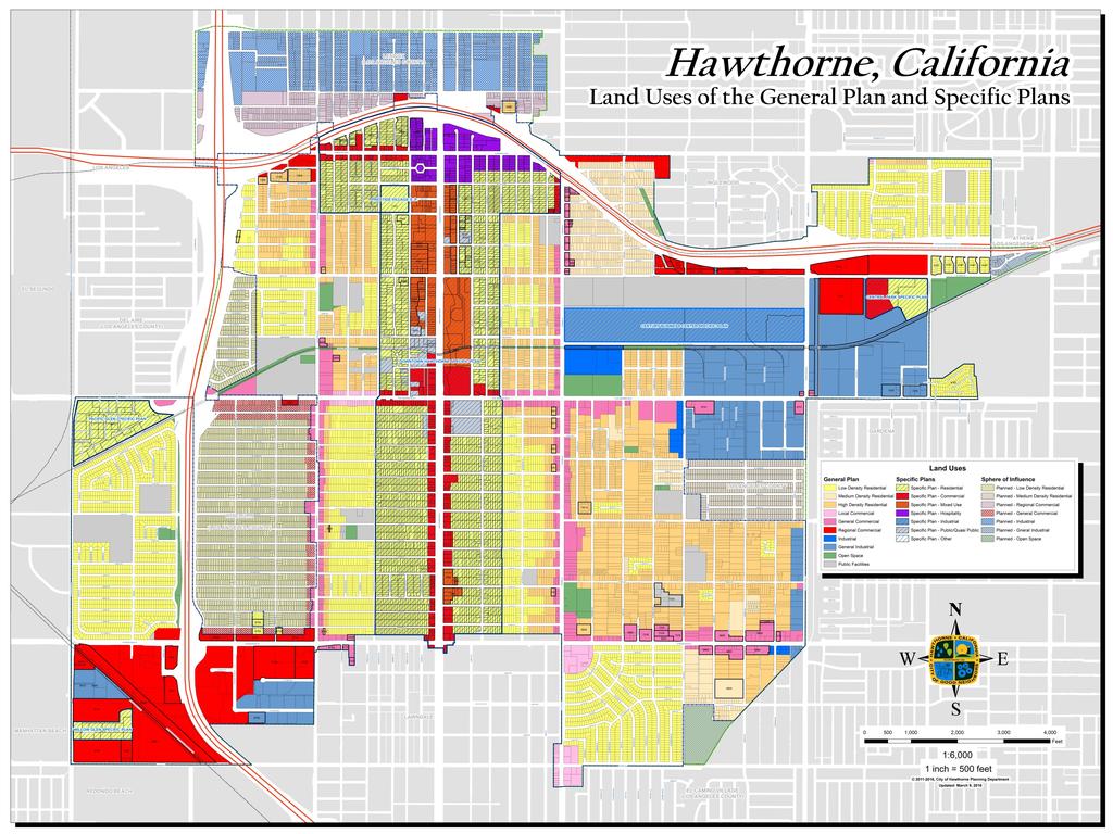
50
PLANNING COMMISSION RESOLUTION NO GREEN LINE MIXED USE SPECIFIC PLAN
 PLANNING COMMISSION RESOLUTION NO. 2017-16 GREEN LINE MIXED USE SPECIFIC PLAN A RESOLUTION OF THE PLANNING COMMISSION OF THE CITY OF HAWTHORNE RECOMMENDING THAT THE CITY COUNCIL OF THE CITY OF HAWTHORNE,
AGENDA ITEM NO. 17. Interim City Manager: Arnold Shadbehr Dir. Of Planning: Brian James
 AGENDA ITEM NO. 17 CITY OF HAWTHORNE CITY COUNCIL AGENDA BILL For the meeting of October 23, 2018 Originating Department: Planning and Community Development Interim City Manager: Arnold Shadbehr Dir. Of
The transportation system in a community is an
 7 TRANSPORTATION The transportation system in a community is an important factor contributing to the quality of life of the residents. Without a sound transportation system to bring both goods and patrons
A. WHAT IS A GENERAL PLAN?
 I. Introduction A. WHAT IS A GENERAL PLAN? A general plan is the planning guideline for the future of a city. It contains goals and policies which regulate urban development, the protection of the natural
ARLINGTON COUNTY, VIRGINIA
 ARLINGTON COUNTY, VIRGINIA County Board Agenda Item Meeting October 15, 2005 DATE: September 28, 2005 SUBJECT: Request to Advertise the adoption of the 2005 Clarendon Sector Plan C. M. RECOMMENDATION:
AGENDA ITEM No. 13 RESOLUTION No CITY OF HAWTHORNE CITY COUNCIL AGENDA BILL
 AGENDA ITEM No. 13 RESOLUTION No. 7624 CITY OF HAWTHORNE CITY COUNCIL AGENDA BILL For the meeting of May 13, 2014 Originating Department: Planning & Economic Development City Manager: Michael Goodson Director:
WEST OAKLAND SPECIFIC PLAN & DRAFT ENVIRONMENTAL IMPACT REPORT
 WEST OAKLAND SPECIFIC PLAN & DRAFT ENVIRONMENTAL IMPACT REPORT Landmarks Preservation Advisory Board Public Hearing February 10, 2014 1 Specific Plan Overview Plan Area is generally bounded by I-580 to
MALL REVITALIZATION CASE STUDIES
 MALL REVITALIZATION CASE STUDIES DECEMBER 9, 2012 MALL REVITALIZATION OVERVIEW Introduction Sample Case Studies prepared for Lacey Woodland District Steering Committee as it considers strategies to revitalize
Welcome to the Oakridge Centre Open House
 Welcome to the Oakridge Centre Open House Why is the City hosting this event? This open house is to inform you of a rezoning application submitted to the City of Vancouver to amend the existing CD-1 (Comprehensive
CITY OF CHARLOTTESVILLE, VIRGINIA CITY COUNCIL AGENDA
 CITY OF CHARLOTTESVILLE, VIRGINIA CITY COUNCIL AGENDA Agenda Date: December 16, 2013 Action Required: Adoption of Resolution Presenter: Staff Contacts: Title: James E. Tolbert, AICP, Director of NDS James
Town Center (part of the Comprehensive Plan)
") Town Center (part of the Comprehensive Plan) Mercer Island Town Center Looking North (2014) In 1994, a year-long process culminated in a set of design guidelines and code requirements for the Town Center
Town Center (part of the Comprehensive Plan) Mercer Island Town Center Looking North (2014) In 1994, a year-long process culminated in a set of design guidelines and code requirements for the Town Center
TREASURE COAST REGIONAL PLANNING COUNCIL M E M O R A N D U M. To: Council Members AGENDA ITEM 5H
 TREASURE COAST REGIONAL PLANNING COUNCIL M E M O R A N D U M To: Council Members AGENDA ITEM 5H From: Date: Subject: Staff October 17, 2008 Council Meeting Local Government Comprehensive Plan Review Draft
ORDINANCE NO
 ATTACHMENT CC-1 ORDINANCE NO. 13-2113 AN ORDINANCE OF THE CUPERTINO CITY COUNCIL APPROVING THE REZONING OF AN APPROXIMATELY 1.1 ACRE AREA FROM PARK AND RECREATION (PR) TO PLANNED INDUSTRIAL PARK (P(MP))
2035 General Plan Update and Belmont Village Specific Plan. Joint Study Session with the City Council and Planning Commission April 12, 2016
 2035 General Plan Update and Belmont Village Specific Plan Joint Study with the City Council and Planning Commission April 12, 2016 Agenda 1. Welcome and Introductions 2. General Plan Update Status of
Urban Planning and Land Use
 Urban Planning and Land Use 701 North 7 th Street, Room 423 Phone: (913) 573-5750 Kansas City, Kansas 66101 Fax: (913) 573-5796 Email: planninginfo@wycokck.org www.wycokck.org/planning To: From: City Planning
North Fair Oaks Community Plan Summary and Information
 North Fair Oaks Community Plan Summary and Information WHAT IS THE NORTH FAIR OAKS COMMUNITY PLAN? The North Fair Oaks Community Plan is part of the San Mateo County General Plan, and establishes policies
V. Vision and Guiding Principles
 V. Vision and Guiding Principles The Master Plan for the Powers Ferry Corridor seeks a foundation in the desires of the community. At times, various elements of the community offered opposing viewpoints,
CITY OF ALAMEDA PLANNING BOARD Draft RESOLUTION
 CITY OF ALAMEDA PLANNING BOARD Draft RESOLUTION A RESOLUTION OF THE PLANNING BOARD OF THE CITY OF ALAMEDA APPROVING DESIGN REVIEW AND DEVELOPMENT PLAN AMENDMENT APPLICATION PLN13-0157 TO CONSTRUCT ELEVEN
WATERFORD Plan of Preservation, Conservation and Development Supplement Part 1 - Policy Element
 WATERFORD 2012 Plan of Preservation, Conservation and Development 2015 Supplement Part 1 - Policy Element Effective June 11, 2015 2015 Plan Update GOAL To respond to the evolving land use needs and continually
S A C R A M E N T O C O U N T Y JACKSON HIGHWAY & GRANT LINE EAST VISIONING STUDY
 JACKSON HIGHWAY & GRANT LINE EAST S A C R A M E N T O C O U N T Y P L A N N I N G D E P A R T M E N T SUMMARY AND WORKBOOK November 19, 2008 History of the Visioning Study Sacramento County has two growth
RESOLUTION NO. R Refining the route, profile and stations for the Downtown Redmond Link Extension
 RESOLUTION NO. R2018-32 Refining the route, profile and stations for the Downtown Redmond Link Extension MEETING: DATE: TYPE OF ACTION: STAFF CONTACT: Capital Committee Board PROPOSED ACTION 09/13/2018
DALY CITY VISIONING PROCESS COMMUNITY WORKSHOP 3 MAY 8, 2008
 DALY CITY VISIONING PROCESS COMMUNITY WORKSHOP 3 MAY 8, 2008 PROCESS General Plan - a statement of the community s values, vision and aspirations for now and into the future... Timeframe LONG TERM - 2030
RESOLUTION NO. WHEREAS, the Planning Commission of the City certified said General Plan Update FPEIR, which certification was not appealed; and
 RESOLUTION NO. A RESOLUTION OF THE COUNCIL OF THE CITY OF SAN JOSE APPROVING THE MONTGOMERY 7 PROPOSED RESIDENTIAL AND RETAIL PROJECT 565 LORRAINE AVENUE ADDENDUM TO THE DIRIDON STATION AREA PLAN FINAL
EXHIBIT A. Tax Increment Reinvestment Zone No. 1 (Town Center) First Amended Project Plan 1
 First Amended Project Plan 1") EXHIBIT A Tax Increment Reinvestment Zone No. 1 (Town Center) First Amended Project Plan 1 1 As amended by Resolution No. 2008-02-001(TR1R) of the Tax Increment Reinvestment Zone No.1, and approved to
EXHIBIT A Tax Increment Reinvestment Zone No. 1 (Town Center) First Amended Project Plan 1 1 As amended by Resolution No. 2008-02-001(TR1R) of the Tax Increment Reinvestment Zone No.1, and approved to
Plano Tomorrow Vision and Policies
 Plano Tomorrow Vision and Policies PLANO TOMORROW PILLARS The Built Environment The Social Environment The Natural Environment The Economic Environment Land Use and Urban Design Transportation Housing
Corridor Vision. 1Pursue Minnehaha-Hiawatha Community Works Project. Mission of Hennepin County Community Works Program
 1Pursue Minnehaha-Hiawatha Community Works Project Minnehaha-Hiawatha Community Works is a project within the Hennepin Community Works (HCW) program. The mission of the HCW program is to enhance how the
2. INTRODUCTION 2.1 AUTHORITY 2.2 PURPOSE AND INTENT 2.3 SITE LOCATION
 2. INTRODUCTION 2.1 AUTHORITY The City of Gardena initiated and prepared the Artesia Corridor Specific Plan pursuant to the provisions of California Government Code, Title 7, Division 1, Chapter 3, Article
PUBLIC OPEN HOUSE HURONTARIO-MAIN CORRIDOR SECONDARY PLAN
 PUBLIC OPEN HOUSE HURONTARIO-MAIN CORRIDOR SECONDARY PLAN Tuesday, February 28, 2012 6pm 9pm 1 st Floor Atrium, City Hall 2 Wellington Street West, Brampton 1 POLICY FRAMEWORK The 2006 Provincial Growth
Policies and Code Intent Sections Related to Town Center
 Policies and Code Intent Sections Related to Town Center The Town Center Vision is scattered throughout the Comprehensive Plan, development code and the 1994 Town Center Plan. What follows are sections
City Council Special Meeting AGENDA ITEM NO. C.
 City Council Special Meeting AGENDA ITEM NO. C. DATE: 01/04/2019 TO: Honorable Mayor and City Council Members SUBJECT: Transit Villages Specific Plan project Study Session (Development Services Director
The Five Components of the McLoughlin Area Plan
 The Five Components of the McLoughlin Area Plan This documents contains the complete language of the five components of the McLoughlin Area Plan: The Vision Statement The Values The Guiding Principles
Planning Commission Report
 Planning Commission Report To: From: Subject: Planning Commission Meeting: January 6, 2016 Agenda Item: 8-B Planning Commission David Martin, Planning & Community Development Director Introduction to the
THE TOWN OF WASAGA BEACH
 THE TOWN OF WASAGA BEACH Downtown Development Master Plan Committee of the Whole Presentation January 26 th 2017 Uses within this designation should reflect a dependence on tourism as opposed to the permanent
Executive Summary. NY 7 / NY 2 Corridor
 Executive Summary NY 7 / NY 2 Corridor Transportation and Land Use Study December 2005 Prepared for: Town of Colonie Capital District Transportation Committee Prepared by: Introduction: Land use decisions
CHAPTER 3 VISION, GOALS, & PLANNING PRINCIPLES. City of Greensburg Comprehensive Plan. Introduction. Vision Statement. Growth Management Goals.
 CHAPTER 3 VISION, GOALS, & PLANNING PRINCIPLES Introduction The Greensburg Comprehensive Plan is intended as a working community document. A combination of long and short-term goals, this document is intended
Executive Summary General Plan Amendment Initiation
 Executive Summary General Plan Amendment Initiation HEARING DATE: AUGUST 6, 2015 Date: July 30, 2015 Case No.: 2011.0409PCA Project Address: 925 Mission Street and various parcels (aka 5M ) Existing Zoning:
3. VISION AND GOALS. Vision Statement. Goals, Objectives and Policies
 Vision Statement Queen Creek s interconnected network of parks, trails, open spaces and recreation opportunities provide safe and diverse activities and programs that sustain its unique, small town, equestrian
AGENDA 07/14/11 PLANNING COMMISSION Meeting
 AGENDA 07/14/11 PLANNING COMMISSION Meeting MEETING DATE: Thursday, July 14, 2011 MEETING TIME: MEETING PLACE: VIDEO: 5:30 p.m. City Council Chambers, City Hall 350 Main Street El Segundo, California 90245-0989
Introduction. Chapter 1. Purpose of the Comprehensive Plan Plan Organization Planning Process & Community Input 1-1
 Chapter 1 Introduction Lakewood 2025: Moving Forward Together Purpose of the Comprehensive Plan Plan Organization Planning Process & Community Input 1-1 Purpose of the Comprehensive Plan The Comprehensive
CITY OF SEASIDE STAFF REPORT
 Item 12 CITY OF SEASIDE STAFF REPORT TO: FROM: BY: Honorable Mayor and City Council Ray Corpuz, City Manager Diana Ingersoll, Deputy City Manager, Resource Management Services Rick Medina, Senior Planner
MAIN STREET ECONOMIC DEVELOPMENT STRATEGY
 MAIN STREET ECONOMIC DEVELOPMENT STRATEGY A PATHWAY TO A BETTER POUGHKEEPSIE DRAFT Working Paper #2: Planning Strategies Submitted December 1 st, 2015 to the City of Poughkeepsie LAND USE LAW CENTER PACE
RECREATION AND OPEN SPACE ELEMENT GOALS, OBJECTIVES, AND POLICIES
 RECREATION AND OPEN SPACE ELEMENT GOALS, OBJECTIVES, AND POLICIES Goal 7 To provide park facilities, recreation programs, and open space resources that are safe, adequate, and accessible to all City residents,
ITEM #8. Regional Smart Growth Program. Regional Smart Growth Program. Presentation Overview. Coast Highway Vision and Stategic Plan.
 Regional Smart Growth Program Economic Development Commission What is Smart Growth? Adopted as part of the Regional Comprehensive Plan (RCP) RCP provides vision for region based on Smart Growth and sustainability
DRAFT PLAN PRESENTATION
 DRAFT PLAN PRESENTATION 1.23.2018 AGENDA Process Project Schedule Results from Visioning Workshop Draft Plan Highlights Concept Plans Feedback Next Steps PROJECT SCHEDULE KICK-OFF WORKSHOP August 29 th
SAN FRANCISCO PLANNING DEPARTMENT
 PLANNING DEPARTMENT Certificate of Determination EXEMPTION FROM ENVIRONMENTAL REVIEW Case No.: Project Address: Zoning: UMU (Urban Mixed Use) Zoning District 68-X Height and Bulk District Life Science
The Village of Shirlington
 The Village of Shirlington Suburban Smart Growth Without Rail Transit July 2018 Agenda History (1940 to present) Attributes and Outcomes Lessons Learned Setting the Stage Arlington County Arlington is
ADOPTION OF THE REVISED OPEN SPACE AND CONSERVATION ELEMENT OF THE GENERAL PLAN
 TO: FROM: SUBJECT: Honorable Mayor and City Council Planning Department ADOPTION OF THE REVISED OPEN SPACE AND CONSERVATION ELEMENT OF THE GENERAL PLAN RECOMMENDATION: It is recommended that the City Council:
ORDINANCE WHEREAS, this Ordinance is consistent with the City of Winter Garden Comprehensive Plan; and
 ORDINANCE 17-06 AN ORDINANCE OF THE CITY COMMISSION OF THE CITY OF WINTER GARDEN, FLORIDA, CREATING ARTICLE XIV OF CHAPTER 118 OF THE CITY OF WINTER GARDEN CODE OF ORDINANCES PROVIDING FOR THE EAST PLANT
City of Long Beach. creating vibrant and exciting places
 City of Long Beach creating vibrant and exciting places Land Use Element Urban Design Element Overview of the two draft General Plan elements Discuss areas of change Economic goals of the plans Case study
CHAPTER 12 IMPLEMENTATION
 CHAPTER 12 IMPLEMENTATION The 2010 Town of Denton Comprehensive Plan is intended to capture a vision of the future of Denton. As such, it provides a basis for a wide variety of public and private actions
ARLINGTON COUNTY, VIRGINIA
 ARLINGTON COUNTY, VIRGINIA County Board Agenda Item Meeting of July 21, 2012 DATE: July 12, 2012 SUBJECT: SP #416 SITE PLAN AMENDMENT to modify condition #6 to eliminate requirement to provide a pedestrian
Visioning Statement and Guiding Principles
 Visioning Statement and Guiding Principles Planning for the Future The General Plan The General Plan represents Woodland's shared vision of the future and defines a path to lead the community toward its
ORANGE LINE TRANSIT NEIGHBORHOOD PLANS VAN NUYS NEIGHBORHOOD COUNCIL, PLUM COMMITTEE DEPARTMENT OF CITY PLANNING, CITY OF LOS ANGELES
 Photo: Mission Meridian(Moule & Polyzoides) ORANGE LINE TRANSIT NEIGHBORHOOD PLANS VAN NUYS NEIGHBORHOOD COUNCIL, PLUM COMMITTEE DEPARTMENT OF CITY PLANNING, CITY OF LOS ANGELES JULY 18, 2018 Project partially
SUMMERSIDE / MT. CARMEL REINVESTMENT CORRIDOR COMMUNITY DEVELOPMENT STRATEGY
 SUMMERSIDE / MT. CARMEL REINVESTMENT CORRIDOR COMMUNITY DEVELOPMENT STRATEGY FEBRUARY 2013 I. Location of the Summerside/Mt. Carmel Reinvestment Corridor The Summerside/Mt. Carmel Reinvestment Corridor
ARLINGTON COUNTY, VIRGINIA
 ARLINGTON COUNTY, VIRGINIA County Board Agenda Item Meeting of April 23, 2019 DATE: April 12, 2019 SUBJECT: SP #413 SITE PLAN AMENDMENT to permit a fixed bar in a private outdoor café space with associated
III. PROJECT DESCRIPTION
 III. PROJECT DESCRIPTION LOCATION AND BOUNDARIES The City of Manhattan Beach is located in the South Bay region of Los Angeles County, California, approximately 2 miles south of the Los Angeles International
Honorable Mayor and Members of the City Council. Submitted by: Eric Angstadt, Director, Planning and Development
 Office of the City Manager ACTION CALENDAR January 29, 2013 To: From: Honorable Mayor and Members of the City Council Christine Daniel, City Manager Submitted by: Eric Angstadt, Director, Planning and
City of Tacoma Planning and Development Services
 Agenda Item E-1 City of Tacoma Planning and Development Services To: Planning Commission From: Elliott Barnett, Planning Services Division Subject: Tacoma Mall Regional Center Subarea Plan and EIS Meeting
Chapter 1.0 Introduction
 Chapter 1.0 Introduction 1.1 Background The North Metro commuter rail line is part of the RTD FasTracks regional transit system expansion program to build more than 100 miles of rail transit throughout
BROOKLYN PARK / 85TH AVE LRT STATION CDI DEVELOPMENT GUIDELINES DRAFT
 August 2018 Page intentionally left blank The Brooklyn Park Library adjacent to the 85th Ave LRT Station Area. OVERVIEW The Blue Line LRT Extension / Bottineau corridor offers a unique opportunity to leverage
PSRC REVIEW REPORT & CERTIFICATION RECOMMENDATION
 PSRC REVIEW REPORT & CERTIFICATION RECOMMENDATION KITSAP COUNTY COUNTYWIDE PLANNING POLICIES July 2, 2012 BACKGROUND A major emphasis of the Washington State Growth Management Act (GMA) is the need to
REPORT TO PLANNING COMMISSION City of Sacramento
 REPORT TO PLANNING COMMISSION City of Sacramento 915 I Street, Sacramento, CA 95814-2671 3 PUBLIC HEARING September 23, 2010 Members of the Planning Commission Subject: Florin Road Corridor Plan - Policies
Staff Report and Recommendation
 Community Planning and Development Planning Services 201 W. Colfax Ave., Dept. 205 Denver, CO 80202 p: 720.865.2915 f: 720.865.3052 www.denvergov.org/cpd TO: City Council Neighborhoods and Planning Committee
Gold Line Bus Rapid Transit Transit Oriented Development (BRTOD) Helmo Station Area Plan
 Helmo Station Area Plan") Appendix F Gold Line Bus Rapid Transit Transit Oriented Development (BRTOD) Helmo Station Area Plan Introduction and Purpose of the Plan The Gold Line Bus Rapid Transit facility is an eleven-mile dedicated
Appendix F Gold Line Bus Rapid Transit Transit Oriented Development (BRTOD) Helmo Station Area Plan Introduction and Purpose of the Plan The Gold Line Bus Rapid Transit facility is an eleven-mile dedicated
WHEREAS, the current Comprehensive Plan was adopted in 2005; and
 RESOLUTION 2018-06 RESOLUTION TO AMEND THE CITY S COMPREHENSIVE PLAN TO (1) AMEND CHAPTER 4 TO ADD A SPECIAL REVITALIZATION DISTRICT FOR EDUCATION AND ECONOMIC DEVELOPMENT ; (2) DESIGNATE ON THE FUTURE
CHARLES PUTMAN CHARLES PUTMAN AND ASSOCIATES, INC
 MEMORANDUM CHARLES PUTMAN & ASSOCIATES, INC. LAND DEVELOPMENT CONSULTANTS PLANNING ZONING PERMITTING 4722 NW Boca Raton Boulevard, Suite C-106 Boca Raton, Florida 33431 Phone: 561/994-6411 FAX: 561/994-0447
Draft for Public Review. The Market and Octavia Neighborhood Plan
 Draft for Public Review The Market and Octavia Neighborhood Plan San Francisco Planning Department As Part of the Better Neighborhoods Program December 2002 IOverview Why Plan a Better Neighborhood Here
PC RESOLUTION NO GRADING PLAN MODIFICATION (GPM)
") PC RESOLUTION NO. 16-07-26- GRADING PLAN MODIFICATION (GPM) 16-006 A RESOLUTION OF THE PLANNING COMMISSION OF THE CITY OF SAN JUAN CAPISTRANO, CALIFORNIA APPROVING GRADING PLAN MODIFICATION (GPM) 16-006,
PC RESOLUTION NO. 16-07-26- GRADING PLAN MODIFICATION (GPM) 16-006 A RESOLUTION OF THE PLANNING COMMISSION OF THE CITY OF SAN JUAN CAPISTRANO, CALIFORNIA APPROVING GRADING PLAN MODIFICATION (GPM) 16-006,
City of San Mateo General Plan Circulation Element. Adopted October 18, 2010
 City of San Mateo General Plan Circulation Element. Adopted October 18, 2010 TRANSIT (pp III-20 to III-21) Exhibit A - Item 20 Excerpt from 2010 Downtown Plan Update and enacting Resolution C 3.4: Hillsdale
Subject: 30 Otis Street, Evaluation of Shadow on Proposed 11th and Natoma Park
 Date: September 5, 2018 To: Recreation and Park Commission Capital Committee Through: Philip A. Ginsburg, General Manager Toks Ajike, Director, Capital & Planning Division From: Brian Stokle, Planner,
Dyersville Downtown Plan. Open House October 24, 2017
 Dyersville Downtown Plan Open House October 24, 2017 What is a Comprehensive Plan? - Vision - Guidance for decisions - Basis for regulations What is a Downtown Plan? - Understand priorities - Identify
Table L-1 Summary Action Strategy. Action Item Timing Status Responsible Agency
 CHAPTER 4: CIRCULATION ELEMENT ISSUE #1: MAJOR THOROUFARES AND TRANSPORTATION ROUTES A balanced transportation system for Fontana is provided that meets the mobility needs of current and future residents
South Davis County COMMUNITY SPOTLIGHT
 South Davis County COMMUNITY SPOTLIGHT Davis/SLC Community Connector Bus Rapid Transit line connecting SLC & Davis County RTP Phase 1 Project Generate 3,100 average weekday riders Relieve congestion on
The West Vaughan Employment Area Secondary Plan Policies
 Part 2: The West Vaughan Employment Area Secondary Plan Policies 2.1 General Policies It is the policy of Council: 2.1.1. That the West Vaughan Employment Area (the WVEA), identified on Schedule 1, will
Council approve the general plan amendment, zone change, and planned development overlay zone; and
 1 1 RESOLUTION NO. 1- A RESOLUTION OF THE CITY COUNCIL OF THE CITY OF SAN GABRIEL, CALIFORNIA CERTIFYING THE ENVIRONMENTAL IMPACT REPORT FOR THE OLSON RESIDENTIAL COMMUNITY PROJECT FOR PURPOSES OF THE
4.1.3 LAND USE CATEGORIES
 4.1.3 LAND USE CATEGORIES a. City Center District The City Center District incorporates the existing character and mix of uses in downtown Belmont to encourage redevelopment and new development in keeping
CHAPTER 7: VISION AND ACTION STATEMENTS. Noble 2025 Vision Statement
 CHAPTER 7: VISION AND ACTION STATEMENTS This chapter presents the vision, policy and action statements that transform the comprehensive planning study, an analysis of Noble s past, future trends and community
Santa Monica Chamber of Commerce DSP Subcommittee s DSP EIR Scoping Comments and Preliminary Comments on the DSP Framework
 Santa Monica Chamber of Commerce DSP Subcommittee s DSP EIR Scoping Comments and Preliminary Comments on the DSP Framework The Chamber of Commerce s DSP Subcommittee s comments on the scope of the DSP
RESOLUTION NO. PC
 RESOLUTION NO. PC 2018-14 A RESOLUTION OF THE CITY OF ENCINITAS PLANNING COMMISSION RECOMMENDING CITY COUNCIL ADOPTION OF ORDINANCE NO. 2018-05, ADOPTING AMENDMENTS TO THE LOCAL COASTAL PLAN, NORTH 101
~P'~'~; SAN FRANCISCO
 ~o counr~, ~P'~'~; SAN FRANCISCO ~'.~ PLANNING DEPARTMENT a 2 757 O~~~S 0 Case No.: Project Address: Zoning: Certificate of Determination COMMUNITY PLAN EVALUATION UMU (Urban Mixed Use) District 58-X Height
3. Project Description
 3.1 PROJECT LOCATION The Platinum Triangle (herein after also referred to as the Project Area ) is located at the confluence of the Interstate 5 (I-5 Freeway) and the State Route 57 (SR-57 Freeway), in
Comprehensive Plan. Faribault, Minnesota. Hoisington Koegler Group Inc. Claybaugh Preservation Architecture Inc. Howard R. Green Company Bonz/REA
 Comprehensive Plan Faribault, Minnesota Adopted by the Faribault City Council July 8, 2003 prepared for: prepared by: Hoisington Koegler Group Inc. Claybaugh Preservation Architecture Inc. Howard R. Green
DOWNTOWN AREA PLAN. June 9, 2009
 DOWNTOWN AREA PLAN June 9, 2009 Issues Identified by Councilmembers Overlap with Southside Plan Southwest Residential Area & Herrick Shadows & Residential Areas Shadows on Streets & Canyon Effect Transit
PINE CURVE REZONING. Property does not meet criteria for open space preservation and is not a candidate for a park
 PINE CURVE REZONING BACKGROUND Purchased as two parcels in 2001 and 2002 Annexed and Zoned Greater Downtown District Historic Center September 25, 2002 and October 7, 2002 WHAT THE PROJECT IS AND IS NOT
City of Welland Commercial Policies. Public Information Centre March 25 th, 2009
 City of Welland Commercial Policies Public Information Centre March 25 th, 2009 Presentation Outline Presentation will address the following four areas: Purpose of this Public Information Centre? Why does
PC RESOLUTION NO ARCHITECTURAL CONTROL (AC)
") PC RESOLUTION NO. 16-07-26- ARCHITECTURAL CONTROL (AC) 15-035 A RESOLUTION OF THE PLANNING COMMISSION OF THE CITY OF SAN JUAN CAPISTRANO, CALIFORNIA APPROVING ARCHITECTURAL CONTROL (AC) 15-035, INN AT
PC RESOLUTION NO. 16-07-26- ARCHITECTURAL CONTROL (AC) 15-035 A RESOLUTION OF THE PLANNING COMMISSION OF THE CITY OF SAN JUAN CAPISTRANO, CALIFORNIA APPROVING ARCHITECTURAL CONTROL (AC) 15-035, INN AT
NOTICE OF SPECIAL MEETING
 NOTICE OF SPECIAL MEETING Pursuant to Section 54956 of the Government Code of the State of California, a Special meeting of the Tracy City Council is hereby called for: Date/Time: Location: Tuesday, April
TRANSPORTATION ELEMENT GOALS, OBJECTIVES, AND POLICIES
 TRANSPORTATION ELEMENT GOALS, OBJECTIVES, AND POLICIES GOAL 2 The City shall provide a safe, convenient, effective, and energy efficient multimodal transportation system which is coordinated with the Future
D-O LRT Zoning Discussion. Chapel Hill Boards & Commissions October 16, 2017
 D-O LRT Zoning Discussion Chapel Hill Boards & Commissions October 16, 2017 Update on Overall D-O LRT Station Area Initiative Objectives Design and educate on principles of Good Transit-Oriented Development
MOUNT BAKER TOWN CENTER: THE 2014 REZONE AND TRANSIT ORIENTED DEVELOPMENT. By Talis Abolins
 MOUNT BAKER TOWN CENTER: THE 2014 REZONE AND TRANSIT ORIENTED DEVELOPMENT By Talis Abolins In 2014, the City of Seattle adopted Ordinance 124513, and created a transit oriented rezone over the area known
LOS ANGELES CITY PLANNING DEPARTMENT STAFF REPORT
 LOS ANGELES CITY PLANNING DEPARTMENT STAFF REPORT LOS ANGELES CITY PLANNING COMMISSION CASE NO: CPC 2006-9374 CRA CEQA: Exempt DATE: December 21, 2006 Location: Valley Plaza and Laurel Plaza TIME: after
Denton. A. Downtown Task Force
 2 Public Involvement Early and ongoing public involvement was solicited so that the public had ample opportunity to help direct the DTIP s concepts and implementation strategies. The residents of Denton
9 CITY OF VAUGHAN OFFICIAL PLAN AMENDMENT NO BOCA EAST INVESTMENTS LIMITED
 9 CITY OF VAUGHAN OFFICIAL PLAN AMENDMENT NO. 631 - BOCA EAST INVESTMENTS LIMITED The Planning and Economic Development Committee recommends the adoption of the recommendations contained in the following
Tacoma Mall Neighborhood Subarea Plan & EIS. Planning Commission January 18, 2017
 Tacoma Mall Neighborhood Subarea Plan & EIS Planning Commission January 18, 2017 Objectives Develop one or more options for connectivity requirement What is the intent? Key considerations Range of options
WEST OAKLAND SPECIFIC PLAN Final Plan. 2. Vision & Goals. 2.1 Community-Based Goals and Objectives
 WEST OAKLAND SPECIFIC PLAN Final Plan 2. Vision & Goals 2.1 Community-Based Goals and Objectives June 2014 2: Vision & Goals The vision of the West Oakland Specific Plan is to see this remarkable community
Silverdale Regional Center
 Silverdale Regional Center Vision for Silverdale Regional Center The Silverdale Regional Center Plan (Plan) will guide the evolution of the Silverdale Regional Center from a collection of strip malls and
1.0 Purpose of a Secondary Plan for the Masonville Transit Village
 Report to Planning and Environment Committee To: Chair and Members Planning & Environment Committee From: John M. Fleming Managing Director, Planning and City Planner Subject: Masonville Transit Village
hermitage town center
 hermitage town center A Community Vision prepared by Strada for The City of Hermitage and The Mercer County Regional Planning Commission January 2007 table of contents introduction 3 design principles
Port Lavaca Future Land Use
 Port Lavaca Future Land Use Introduction The City of Port Lavaca is beginning to see sustained growth, after many years of relative stable population. New single family homes, apartments, and businesses
1 October Dear Citizens of Charlotte and Mecklenburg County,
 1 October 2011 Dear Citizens of Charlotte and Mecklenburg County, As co-chairs of the Center City 2020 Vision Plan Steering Committee, we are proud to present the Center City 2020 Vision Plan, which sets