Land Use and Management Plan Potts Preserve. Executive Summary
|
|
|
- Stella McBride
- 5 years ago
- Views:
Transcription


1 Land Use and Management Plan Potts Preserve August 2011
2 Table of Contents... 1 Potts Preserve at a Glance... 1 Planning Process... 2 and... 6 Resource Protection and Security Program... 6 Public Use Program... 6 Land Maintenance Program... 7 Fire Management Program... 7 Exotic Species Control Program... 7 Water Resources and Natural Communities Restoration Program... 8 Resource Utilization Program... 8 Resource Monitoring Program... 8 Challenges to Achieving... 9 Potts Preserve Land Use and Management Plan Page i
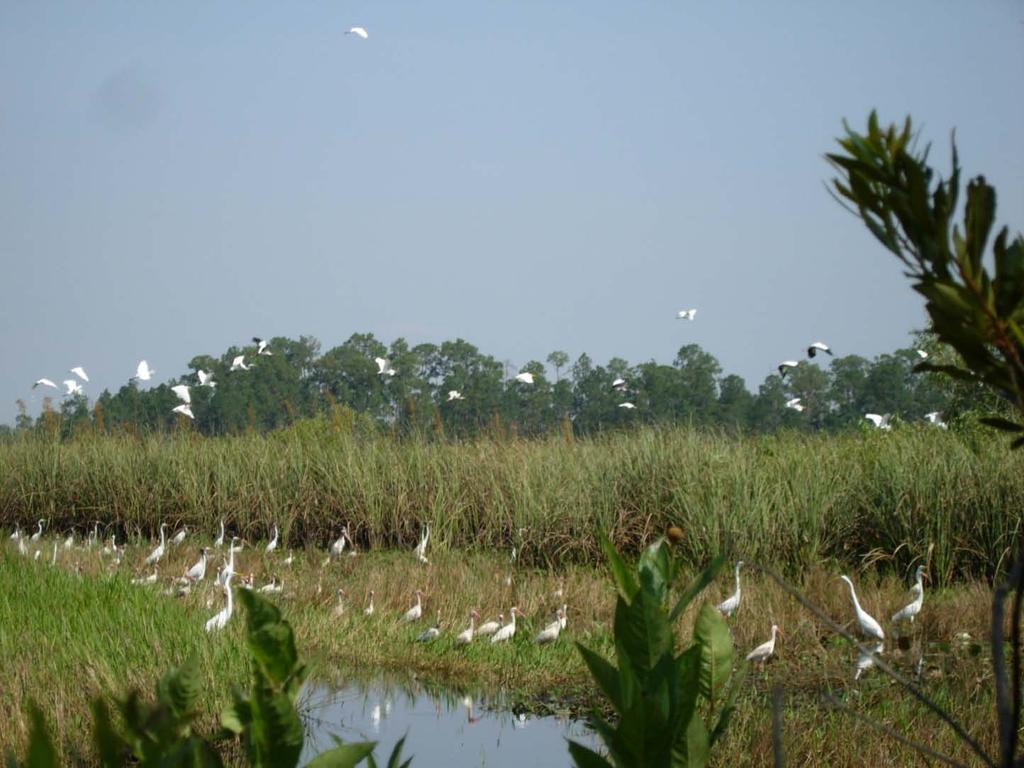
3 The mission of the Southwest Florida Water Management District is to manage water and related natural resources to ensure their continued availability while maximizing environmental, economic and recreational benefits. Central to this mission is protecting and maintaining water and water related natural resources that provide the District s 16-county region with its existing and future water supply and maintaining the balance between the land-use needs of current and future users. The District acquires and manages lands in support of this mission, and the District s goals and areas of responsibility. To ensure that District lands are used and managed in ways that are consistent with Florida Statutes and the District s mission and goals, the District adopts Land Use and Management Plans. These plans guide the use and management of properties for a specific planning horizon by establishing a continuum of geographic zones determined by factors that include previously adopted management plans, water and natural resource data, existing recreational amenities and demands, adjacent land uses and public input. Land Use and Management Plans are created to maximize the quality of experience for recreationists and other users in ways that are compatible with the protection and sustainability of water resources and related natural systems. This executive summary provides a brief description of the property, summarizes the analysis and findings contained within the formal land use and management plan, and identifies programmatic accomplishments and goals for the relevant planning horizons. Potts Preserve at a Glance Potts Preserve is located along the northwest border of Citrus County (Figure 1) within the Withlacoochee River watershed. Acquisition of lands within the Preserve began in It is part of a contiguous 122,000-acre core of protected public conservation/recreation lands and was primarily acquired to protect, restore and maintain the quality and natural functions of land, water and wetland systems of the state; and for natural flood control and water detention. While several references and depictions in this Land Use and Management Plan may appear to represent the Preserve as more than 9,300 acres, the area within the project limits is, in fact, a mosaic of lands owned and managed by the Southwest Florida Water Management District and lands held in trust by the State of Florida under the designation of sovereign submerged lands. Potts Preserve includes 4 miles of frontage along the Withlacoochee River which is designated by the Florida Department of Environmental Protection as an Outstanding Florida Water. The Preserve is comprised of mesic hammock and other forested uplands that total 3,742 acres with 1,533 acres of pasture and other lands covering the remainder of the uplands. The remainder of Potts Preserve and interwoven state lands consists of basin marsh, swamp and other wetland communities. Important natural resources and their ecological significance are summarized in the Water and Natural Resource Data Section of this plan. The Preserve has a rich historic and prehistoric past. Early accounts from the Seminole Wars indicate that the elevated hammocks along the Withlacoochee River and along the east and west sides of the Tsala Apopka Lake system served as settlement locales for the Seminole Indians and earlier native populations and as sites for their fields. Several archeological sites scattered throughout the Preserve have been identified, are preserved under the guidelines of the state s Division of Historical Resources and are further protected by the District s ownership. Historical Potts Preserve Land Use and Management Plan Page 1
4 uses of the Preserve include cattle grazing, turpentining, logging and hunting. Today, there is a variety of recreational opportunities compatible with the natural communities present at the Preserve including bicycling, birding, backpacking, equestrian riding, hiking, hunting, geocaching, interpretive uses, nature study and photography. Planning Process Governing Board Policy requires that District conservation lands be managed for water supply, natural systems, public access, recreation and education, biodiversity, archaeological resources and forestland. Governing Board Procedure 61-3 provides the framework to implement Policy and to evaluate appropriate land management activities and recreation opportunities on District lands. The process includes the following steps: Review the previously adopted management plan Verify water and natural resource data Delineate management zones Review regional recreational supply and demand Complete land use matrix Obtain public input The formal land use and management plan includes a comprehensive discussion about the natural systems and data evaluated during the development of this plan. This information, combined with information from previous plans is used to delineate management zones. These zones are established to protect and preserve sensitive natural communities, imperiled plant and wildlife populations, and several ongoing restoration projects. Before the land use and management zone map is finalized, District staff conduct a regional recreation assessment to identify nearby recreational opportunities offered by other recreation providers including state and local governments. Additionally, staff inventory the resource-dependant recreation opportunities within the 20-mile radius of the Preserve and identify demographic trends that are likely to influence recreation demands. The land use and management zones established for the Potts Preserve were incorporated into a matrix that contains a broad range of resource-dependant recreation activities and renewable resource land uses. Consistent with preservation objectives, only those resource-based recreation activities that require minimal amenities and can still have a quality recreation experience were considered compatible as depicted in Table 1. The full regional assessment that identifies public lands that are connected to or within proximity of the Preserve available for public use indicates that any future demands for resource-dependant recreation in the region for the next 15 years can be fulfilled by existing recreation opportunities. Based on the intrinsic character of the Preserve, existing and proposed recreational opportunities on public lands within the region, and limitations on the Preserve, the existing trail network and designated uses at the Preserve are satisfactory and appropriate to provide users with a quality passive recreation experience. The location and type of uses are depicted in Figure 2. District staff will continue to monitor future demands in the region for compatible resource-based opportunities that may be compatible at the Preserve. Potts Preserve Land Use and Management Plan Page 2

5 Figure 1. Location and Regional Conservation Corridor Links Potts Preserve Land Use and Management Plan Page 3

6 Figure 2. Potts Preserve Recreation and Zone Map Potts Preserve Land Use and Management Plan Page 4
7 Table 1. Land Use Matrix for Potts Preserve Resource-Dependant Recreation Land Use Categories Management Zones Mobility-impaired access Access-Walkthrough Access-5 vehicle maximum Access->5 vehicles Bicycling- Unimproved dirt trail Birdwatching Camping-Backpacking Camping-Group Equestrian Hiking Geocaching Interpretive areas or trails Nature Viewing Nature Photography Non-Wildlife Manangement Area Hunting Preservation 1 Preservation 2 Preservation 3 Special Protection 1 Special Protection 2 Special Protection 3 Special Protection 4 Recreation 1 Recreation 2 Recreation 3 Recreation 4 Recreation 5 Recreation 6 Special Use 1 Wildlife Management Area Potts Preserve Land Use and Management Plan Page 5
8 and The current Land Use and Management Plan guides the use and management of Potts Preserve throughout the ten-year period from 2010 to This describes the accomplishments that occurred from 1999 to 2010 and the goals identified for 2010 to The various goals and accomplishments are listed according to the corresponding managementrelated program. Additionally, District staff has identified external factors that have the potential to impede appropriate management and use of District lands. Resource Protection and Security Program Entered into contract for security services to patrol lands and provide information and other support to the public. Installed and currently maintain approximately 6.6 miles of boundary fencing. Continue to identify and address security issues at Potts Preserve. Establish strategy to address areas prone to vandalism and unauthorized uses. Implement and adjust strategy as needed. Achieve maintenance-level status. Assess all fencing along the boundary to ensure compliance with legal requirements, and replace/install fencing as necessary. Continuously evaluate effectiveness of security and adapt as appropriate. Public Use Program Designated and marked 30 miles of hiking and multiple use trails and 12 miles of equestrian trails. Twenty miles of trail designated for hiking only are maintained by the Florida Trail Association. Coordinated with the Citrus County Airboat Alliance to establish picnic/recreation area accessible only from sovereign lands. Entered into a use agreement with the Florida Fish and Wildlife Conservation Commission to establish Potts Preserve as a Wildlife Management Area. Entered into agreement with the Florida Trail Association for management of a segment of the Florida Trail through Potts Preserve. Acquired access easement in northwest area of the Preserve for management and maintenance activities. Evaluate recreational amenities to ensure accurate information is presented in periodic Recreation Guide updates. Increase volunteer activity focusing on recreational amenities and resource management services. Schedule public speaking engagements and field trips with adjacent and potentially impacted residential communities and user groups to educate residents and users on resource management activities, particularly ongoing restoration, exotic species control and Potts Preserve Land Use and Management Plan Page 6
9 prescribed fire application. Develop relationships with neighbors and user groups to facilitate communication and feedback loops on management activities. Enhance monitoring program for recreational use areas and trails. Establish methods to most effectively monitor proper use of trails, number of users, effectiveness and success of public access points to accommodate users. Monitor use of adjacent sovereign lands to determine level of impacts on District lands. Monitor trail use in area affected by the berm removal completed in 2010 to determine if desired use of inundated area changes. Determine level of secondary impacts that result from public use of Potts Preserve and implement steps to reverse impacts. Refine monitoring protocols and utilize data to ensure protection of the resource. Land Maintenance Program Stabilized roads as needed. Installed culverts as needed. Conducted boundary surveys to resolve encroachments. Mapped and continue standard maintenance of all roads, firebreaks, gates, culverts, and associated infrastructure. Removed berm road previously linking several upland islands in western area of the Preserve for restoration purposes. Established agreement for maintenance of Dee River Road. Coordinate with local power company to remove old power lines and converter boxes. Remove former ranger residence. Fire Management Program 13,757 acres burned with approximately 40% conducted in the growing season. Burn units are generally on a 3-4 year rotation. Obtain necessary authorization from the DEP for use of heavy equipment in sovereign lands to conduct fire line construction and maintenance. Burn scrub restoration units as needed and apply mechanical preparation as needed. Conduct priority marsh burns west of Main Road when conditions are suitable. Exotic Species Control Program Instituted a systematic invasive species control program targeting exotic flora. A total of $9,935 has been spent since 1998 to treat a variety of exotic plants occurring on the property. Potts Preserve Land Use and Management Plan Page 7
10 Survey for, and treat as necessary, Category I and II exotics following removal of berm sections on Loop Road and Middle Loop Road. Focus will be on roads, haul routes and fill disposal areas. Implement feral hog trapping program. Achieve maintenance level status for treatment of Chinese tallow. Assess District s exotics control program and, if necessary, take practicable measures to maximize effectiveness. Water Resources and Natural Communities Restoration Program Contracted with Florida Natural Areas Inventory (FNAI), Florida State University, to map existing and historic natural communities, quantify current conditions, and record observed plant and wildlife species. Completed removal of approximately 0.8 miles of elevated roads bisecting wetlands to restore hydrology. Completed removal of remnant bridge and causeway material from an area known as Parson s Point that historically connected the property to the town of Hernando. Completed approximately 721 acres of mechanical restoration in upland plant communities (scrub, scrubby flatwoods, and mesic flatwoods). Complete mechanical treatment of remaining scrub restoration units. Complete selective follow-up treatment of overgrown hardwoods. Develop strategy to identify and conduct joint upland restoration and habitat enhancement projects utilizing combined expertise of District and FWC staff. Resource Utilization Program Completed 200 acre pine thinning for restoration in December 2000 that generated $25, in revenue. Continue to evaluate/explore potential for resource management activities to generate revenue, in ways that are renewable, to offset management costs. Resource Monitoring Program Initiated Florida scrub-jay monitoring. Program includes regular surveys to detect new occurrences, presence of juveniles, territory size and population estimates, and banding of individuals for long-term tracking. Completed gopher tortoise burrow surveys in approximately 50% of suitable habitat (scrub, scrubby flatwoods, xeric hammock; xeric pastures and old fields). Implemented gopher tortoise burrow surveys in areas of sub-optimal habitat, especially in mesic hammocks occurring on well-drained soils. Assisted Florida Natural Areas Inventory (FNAI) staff with locations of rare plant populations. Potts Preserve Land Use and Management Plan Page 8
11 Worked with botanists to identify, map, and monitor numerous rare plant populations including state listed species and several tracked by FNAI. Achieve maintenance level status with regard to banding of Florida scrub-jays. Assess status of gopher tortoise population in the Point Lonesome Grove area located in southwest corner of the Preserve and on upland islands on west side of the Preserve. Complete GIS mapping of gopher tortoise locations in all suitable habitat. Challenges to Achieving There are several key factors external to the District that could significantly affect the achievement of long-term goals described in this plan. Below is a summary of external factors that may affect or influence future management of Potts Preserve. Funding for land use and management expenses susceptible to changes in District budget and allocation of land management funds. Exotic flora and fauna that originate offsite and infest Potts Preserve. Increasing restrictions with regard to exotic plant and animal treatments, such as herbicide application restrictions. Difficulty of access to western portion of the property for resource monitoring, prescribed burning, and wildfire suppression due to removal of berm sections of the Loop Road. Narrow windows for conducting marsh burns due to exacting conditions required for effectiveness and smoke management. Absentee property owners adjacent to the Preserve contributing to unauthorized access issues. Legal impediments and policy shifts affecting fire management, such as increasing air quality standards. Development adjacent to or in proximity to the Preserve may impact resources and ecosystem processes within the property. Land use practices of adjacent landowners affecting the property s resources. Natural disasters such as hurricanes, floods, climate change and disease that potentially cause unrecoverable resource losses and affect the long-term balance and viability of populations and functionality. New construction or expansion of primary roads, highways or other development that impact habitat and buffers and affect fire management practices. This executive summary is designed as a companion to the full, comprehensive land use and management plan. It provides a brief description of the property, summarizes the analysis and findings contained within the formal land use and management plan, and identifies programmatic accomplishments and goals for the relevant planning horizons. A detailed land use and management plan is available upon request. Potts Preserve Land Use and Management Plan Page 9
Florida Forever Conservation Needs Assessment Overview Maps
 Florida Forever Conservation Needs Assessment Overview Maps Prepared by Florida Natural Areas Inventory, The maps in this document are derived from the Florida Forever Conservation Needs Assessment, an
Community Conservation Workshop. Lake Placid
 Community Conservation Workshop Lake Placid 2 Community Conservation Program Welcome! We have designed a Community Conservation Program that listens to the needs of community members. We are conducting
SECTION FOUR: MISSION STATEMENT, GOALS & OBJECTIVES
 SECTION FOUR: MISSION STATEMENT, GOALS & OBJECTIVES Chapter Summary Chapter Ten: Mission Statement, Goals & Objectives To fulfill its mission, the Parks and Recreation Commission has identified four basic
This page intentionally blank.
 This page intentionally blank. Parks, Recreation, and Open Space Chapter Relationship to Vision Vision Parks, Recreation and Open Space Chapter Concepts County Government. County government that is accountable
Community Conservation Workshop. Saranac River Basin Communities
 Community Conservation Workshop Saranac River Basin Communities 2 Community Conservation Program Welcome! We have designed a Community Conservation Program that listens to the needs of community members.
RECREATION, OPEN SPACE AND GREENWAYS ELEMENT GOALS, OBJECTIVES, AND POLICIES
 RECREATION, OPEN SPACE AND GREENWAYS ELEMENT GOALS, OBJECTIVES, AND POLICIES GOAL R-1: DEVELOP A RECREATION, OPEN SPACE AND GREENWAYS SYSTEM AS AN INTEGRAL COMPONENT OF AN OVERALL, COUNTY-WIDE ECONOMIC
Pinellas County Greenways
 Pinellas County Greenways USING GREENWAYS TO LINK OPEN SPACES The Florida Greenways Commission has defined a greenway as...a corridor of protected open space that is managed for conservation and/or recreation.
Master Plan Objectives and Policies
 Master Plan Objectives and Policies Introduction This chapter identifies the Park issues and recommended policies established by this Master Plan. The issues were identified through meetings with staff,
DRAFT MAP AMENDMENT FLU 04-4
 DRAFT MAP AMENDMENT FLU 04-4 SW 24 TH AVENUE ROADWAY CORRIDOR The University of Florida participates with the Metropolitan Transportation Planning Organization (MTPO) in its responsibilities for the continuing,
ADOPTED CAPITAL IMPROVEMENT PROGRAM BUDGET ARROYO PROJECTS
 ADOPTED CAPITAL IMPROVEMENT PROGRAM BUDGET ARROYO PROJECTS HAHAMONGNA FY 212-216 Capital Improvement Program Priority Description Total Estimated Costs Appropriated Through FY 211 Adopted FY 212 FY 213
Chapter 5: Natural Resources and Environment
 NATURAL RESOURCES AND ENVIRONMENT 5-1 5 Chapter 5: Natural Resources and Environment BACKGROUND AND INTENT Urban expansion represents the greatest risk for the future degradation of existing natural areas,
systems is available on the Colorado Wetland Information Center (CWIC) website.
 website.") Colorado Natural Heritage Program Wetland Program Plan -- Dec 2015 Status Update and Addendum -- The Colorado Natural Heritage Program (CNHP) developed a Wetland Program Plan (WPP) in 2010 for the planning
Colorado Natural Heritage Program Wetland Program Plan -- Dec 2015 Status Update and Addendum -- The Colorado Natural Heritage Program (CNHP) developed a Wetland Program Plan (WPP) in 2010 for the planning
Yadkin River Greenway Feasibility Study Fact Sheet Village of Clemmons, Town of Lewisville, Town of Bermuda Run
 Fact Sheet Village of Clemmons, Town of Lewisville, Town of Bermuda Run Project Background The Yadkin River Greenway Feasibility Study is a joint project with the Village of Clemmons, the Town of Bermuda
OPEN SPACE CHAPTER 7: OVERVIEW. Preserve open space to protect natural resources, enhance character and provide passive recreation opportunities
 CHAPTER 7: OPEN SPACE OVERVIEW Ridgefield has made tremendous progress permanently preserving areas of town as open space. Open space preservation can serve many important purposes, including: protect
Peninsular Florida Landscape Conservation Cooperative. Marine and Estuarine Priority Resources and Conservation Targets
 Peninsular Florida Landscape Conservation Cooperative Marine and Estuarine Priority Resources and Conservation Targets Why are we here today? Workshop Goals: Develop a list of potential conservation targets
Table of Contents TABLE OF CONTENTS SECTION TITLE PAGE
 TABLE OF CONTENTS SECTION TITLE PAGE 1 INTRODUCTION AND OVERVIEW 1-1 1.1 Purpose and Need 1-1 1.2 Goals and Objectives 1-3 1.3 Overview of the Planning Process 1-5 1.4 Federal and State Requirements and
Burrowing Owl Habitat Project at the Albany Plateau. (a component project of the Gilman Street Playing Fields Project City of Berkeley) March 10, 2006
 March 10, 2006") Burrowing Owl Habitat Project at the Albany Plateau (a component project of the Gilman Street Playing Fields Project City of Berkeley) March 10, 2006 Submitted by The City of Berkeley Project history During
Burrowing Owl Habitat Project at the Albany Plateau (a component project of the Gilman Street Playing Fields Project City of Berkeley) March 10, 2006 Submitted by The City of Berkeley Project history During
PLANNING AND NATURAL RESOURCES COMMITTEE. Public Access Conceptual Design Alternatives for the Red Barn Area of La Honda Creek Open Space Preserve
 PLANNING AND NATURAL RESOURCES COMMITTEE R-17-56 May 9, 2017 AGENDA ITEM AGENDA ITEM 2 Public Access Conceptual Design Alternatives for the Red Barn Area of La Honda Creek Open Space Preserve GENERAL MANAGER
& SUSTAINABILITY PLAN
 Chapter 6: IMPLEMENTATION, MANAGEMENT, & SUSTAINABILITY PLAN Overview The Oxbow Park and Zollman Zoo Master Plan presents a long-term vision for the park. While phasing of improvements is suggested, Olmsted
2.4 FUTURE LAND USE ELEMENT Goals, Objectives and Policies
 GOAL 1: To create developmental patterns that direct future growth to appropriate areas on campus, in a manner that promotes the educational mission of the University, the protection of environmentally
Mendota Heights 2040 Comprehensive Plan Draft Vers
 4 Parks and Trails The City of Mendota Heights boasts a variety of recreational and open space opportunities. Few cities can claim access to regional trails, riverside and lakeside parks, scenic bluffs
Preface. Erie. Scranton. Allentown. Pittsburgh. Harrisburg. Philadelphia
 The Southern Alleghenies Region The Southern Alleghenies Region spans the Laurel Highlands and Allegheny Front in the west across the Appalachians to the east. It is comprised of Blair, Bedford, Cambria,
Parks, Trails, and Open space Element
 Parks, Trails, and Open space Element Parks, Trails, and Open Space element Parks, Recreation, and Open Space are important components of the quality of life desired by the residents of Elk Grove. This
Arlington, Virginia is a worldclass
 EXECUTIVE S U M M A RY Arlington maintains a rich variety of stable neighborhoods, quality schools and enlightened land use policies, and received the Environmental Protection Agency s highest award for
I. STAFF POLICY RECOMMENDATIONS. The following RMP policy strategies are proposed by staff in support of a Scenic Resource Protection Program:
 Policy Consideration: Scenic Resource Protection Program Status: For Consideration by the Highlands Council at September 14, 2006 Work session Date: September 12, 2006 I. STAFF POLICY RECOMMENDATIONS The
G. RECREATION AND OPEN SPACE ELEMENT. The following summarizes the Recreation and Open Space Element:
 G. RECREATION AND OPEN SPACE ELEMENT The purpose of the Element is to provide the framework and direction for a comprehensive system of public and private sites for recreation, including, but not limited
BISCUIT RUN PARK MASTER PLAN
 BOARD OF SUPERVISORS November 14, 2018 BISCUIT RUN PARK MASTER PLAN COUNTY OF ALBEMARLE ANHOLD ASSOCIATES Contents Project Introduction Property Background County Park Planning Process Existing Site &
Chapter 10 IMPLEMENTATION RECOMMENDATIONS
 Chapter 10 IMPLEMENTATION RECOMMENDATIONS The recommended land use plan presented in the previous chapter provides a design for the attainment of the urban and rural development and open space preservation
3. VISION AND GOALS. Vision Statement. Goals, Objectives and Policies
 Vision Statement Queen Creek s interconnected network of parks, trails, open spaces and recreation opportunities provide safe and diverse activities and programs that sustain its unique, small town, equestrian
ARROYO PROJECTS ADOPTED CAPITAL IMPROVEMENT PROGRAM BUDGET
 A RROYO P ROJECTS ADOPTED CAPITAL IMPROVEMENT PROGRAM BUDGET FISCAL YEARS 214-218 HAHAMONGNA Priority Description 1 Hahamongna Watershed Park - Implement Master Plan 211,6 211,6 (77565) 2 Hahamongna -
FEGN Update Goals and Objectives
 FEGN Update Goals and Objectives Update the FEGN to identify a functionally connected statewide ecological network of public and private conservation lands that incorporates new and updated GIS data. Ensure
Public Review Draft Oceanside Subarea Habitat Conservation Plan/ Natural Communities Conservation Plan
 Oceanside Subarea Habitat Conservation Plan/ Natural Communities Conservation Plan Prepared for City of Oceanside Planning Department 300 N. Coast Highway Oceanside, CA 92054 Prepared by Ogden Environmental
City of Missoula and Missoula County Open Space Planning Open House
 City of Missoula and Missoula County Open Space Planning Open House FEBRUARY 6, 2018 The following slides contain the display board content from the open house. Please use boards to answer questions in
CONSERVATION ELEMENT GOALS, OBJECTIVES, AND POLICIES
 CONSERVATION ELEMENT GOALS, OBJECTIVES, AND POLICIES Goal 4 To conserve, manage, appropriately use and protect the natural resources of the City ensuring continued resource availability and environmental
EXHIBIT A CITY OF FORT WALTON BEACH, FLORIDA COASTAL MANAGEMENT & CONSERVATION
 EXHIBIT A CITY OF FORT WALTON BEACH, FLORIDA INTRODUCTION The Coastal Management and the Conservation Elements required by Chapter 9J-5.012 and 5.013, F.A.C., respectively, have been combined into one
Parks, Trails, and Open Space Element
 P arks, Recreation, and Open Space are important components of the quality of life desired by the residents of Elk Grove. This Element of the General Plan addresses the City s goals, policies, and actions
Policy & Procedure Effective Date: Parks Department Page of
 City of Arvada Policy & Procedure Effective Date: Parks Department Page of TITLE: City of Arvada Prairie Dog Habitat Plan APPROVAL: PURPOSE: To establish a plan for the preservation of black-tailed prairie
Support the implementation of Cape Coral's Comprehensive Plan. Protect and utilize the unique natural resources in the City.
 7.0 OVERVIEW - RECOMMENDATIONS Chapter 7 The preparation of the Cape Coral Parks and Recreation Master Plan spanned a period of approximately 12 months. Plan preparation included the input of a wide range
Albion Hills Conservation Area Master Plan. Public Information Session
 Albion Hills Conservation Area Master Plan Public Information Session 1 03.25.2014 Meeting Agenda 1. Project Introduction Property History Current Use Master Plan Process 2. Draft Vision Goals and Objectives
The City shall enhance and improve the accessibility of parks and recreational facilities while protecting their quality. by:
 GOALS, OBJECTIVES AND POLICIES GOAL 1: To provide open space and recreation as an essential element needed for the betterment of the City s character and quality of urban life. The City shall plan for
SCC PRD (2016) COUNTY PARK MASTER PLAN
 COUNTY PARK MASTER PLAN") SCC PRD (2016) COUNTY PARK MASTER PLAN MASTER PLAN UPDATE PARKS AND RECREATION COMMISSION NOVEMBER 7, 2018 PURPOSE OF THE MASTER PLAN The Sanborn County Park Master Plan will provide the Department with
SCC PRD (2016) COUNTY PARK MASTER PLAN MASTER PLAN UPDATE PARKS AND RECREATION COMMISSION NOVEMBER 7, 2018 PURPOSE OF THE MASTER PLAN The Sanborn County Park Master Plan will provide the Department with
Concept Master Plan. for. Draft of. Wildlife Management Area. Prepared for. June, 2008
 Draft of Concept Master Plan for Vermillion Highlands: A Research, Recreation and Wildlife Management Area Prepared for Vermillion Highlands Steering Committee - Minnesota Department of Natural Resources
WATERLOO RECREATION AREA PHASE 2 LONG-RANGE ACTION GOALS. September 2012
 September 2012 PHASE 2 LONG RANGE ACTION GOALS PLAN Long-range management guidance focused on the specific natural resources, historic-cultural resources, recreation opportunities and the education-interpretation
Wisconsin Dept. of Transportation November 2017
 Wisconsin Dept. of Transportation November 2017 Jennifer Gibson WisDOT Environmental Coordinator Mike Helmrick WisDOT Environmental Coordinator Background on compensatory wetland mitigation Site purpose
San Diego River Coalition 2012 Work Plan
 San Diego River Coalition 2012 Work Plan Adopted November 18, 2011 The mission of the San Diego River Coalition is preserve and enhance the San Diego River, its watershed, and its natural, cultural and
Minnesota Department of Natural Resource - Natural Resource Guidance Checklist Conserving Natural Resources through Density Bonuses
 Minnesota Department of Natural Resource - Natural Resource Guidance Checklist Conserving Natural Resources through Density Bonuses NRDB Why Use Density Bonuses & This Checklist Local units of government
Photo by Carlton Ward Jr. Executive Summary
 Photo by Carlton Ward Jr. Executive Summary The Cooperative Conservation Blueprint (Blueprint) is a multi-partner strategic conservation process developed by the Florida Fish and Wildlife Commission (FWC)
CHARLES COUNTY GOVERNMENT RFP NO POPES CREEK RAIL TRAIL DESIGN
 CHARLES COUNTY GOVERNMENT Department of Fiscal and Administrative Services Purchasing Division Telephone: 301-645-0656 July 7, 2015 RFP NO. 16-02 POPES CREEK RAIL TRAIL DESIGN ADDENDUM NUMBER ONE TO: All
PARTF Scoring System for Grants
 PARTF Scoring System for Grants The members of the N.C. Parks and Recreation Authority use the PARTF scoring system as one of several tools to select grant recipients. Please provide all of the information
Member Service Plan Sierra Nevada AmeriCorps Partnership
 Member Service Plan Sierra Nevada AmeriCorps Partnership Service plans lay the framework for what each Member will be doing during their service. Service plans detail the major projects and expected results
HAZARD MITIGATION GOALS AND OBJECTIVES
 SEWRPC Community Assistance Planning Report No. 282, 2nd Edition CITY OF MILWAUKEE ALL HAZARDS MITIGATION PLAN UPDATE Chapter IV HAZARD MITIGATION GOALS AND OBJECTIVES [NOTE: Throughout this plan update
METROPOLITAN COUNCIL 390 North Robert Street, St. Paul, MN Phone (651) ; TDD (651)
 ; TDD (651)") DATE: December 20, 2011 METROPOLITAN COUNCIL 390 North Robert Street, St. Paul, MN 55101 Phone (651) 602-1000; TDD (651) 291-0904 TO: Metropolitan Parks and Open Space Commission FROM: Tori Dupre, Senior
DATE: December 20, 2011 METROPOLITAN COUNCIL 390 North Robert Street, St. Paul, MN 55101 Phone (651) 602-1000; TDD (651) 291-0904 TO: Metropolitan Parks and Open Space Commission FROM: Tori Dupre, Senior
2011 ASLA Design Awards. Westside Creeks Restoration Plan Merit Award AECOM, Fort Collins. Planning & Urban Design
 2011 ASLA Design Awards Westside Creeks Restoration Plan Merit Award AECOM, Fort Collins Planning & Urban Design Project Fact Sheet Category of Entry: Rotating Specialty Award: 2011 2011 ASLA Colorado
The Illinois Department of Transportation and Lake County Division of Transportation. Route 173, including the Millburn Bypass
 The Illinois Department of Transportation and Lake County Division of Transportation welcome you to this Public Hearing for U.S. Route 45 from Illinois Route 132 to Illinois Route 173, including the Millburn
SUSTAINABILITY PLAN OTTAWA COUNTY PARKS AND RECREATION COMMISSION FALL 2017
 SUSTAINABILITY PLAN OTTAWA COUNTY PARKS AND RECREATION COMMISSION FALL 2017 Table of Contents Introduction Natural Resources Quality of Life Community Continuing the Mission Sustainability Measuring Sustainability
North Oakville East Parks Facilities Distribution Plan. November, 2009
 North Oakville East November, 2009 POLICY CONTEXT 1) Purpose a) The purpose of this document is to be a guide for the location, configuration, design and development of the parks system for the North Oakville
Provide and maintain sufficient public parks, recreation facilities, and open space to meet the recreational needs of County residents and visitors.
 (ROS) Goal Provide and maintain sufficient public parks, recreation facilities, and open space to meet the recreational needs of County residents and visitors. OBJECTIVE ROS.01 The County shall acquire,
RESPONSES TO PUBLIC CONCERNS AND QUESTIONS
 RESPONSES TO PUBLIC CONCERNS AND QUESTIONS Stations and Summary Questions for Public Meeting #2 June 23, 2015 General Questions / Concerns: 1. Is there any way this development can raise revenue for the
Executive Summary 1 B
 Executive Summary There are few places in Florida, or America, that equal the natural resource superlatives of the Rainbow River. One of the world s longest spring runs, and one of the clearest aquatic
National Association of Conservation Districts. Kris Hoellen Vice President, Sustainable Programs The Conservation Fund September 19, 2013
 National Association of Conservation Districts Kris Hoellen Vice President, Sustainable Programs The Conservation Fund September 19, 2013 Our Mission The Conservation Fund forges partnerships to conserve
STREAM BUFFERS
 88-415 STREAM BUFFERS 88-415-01 PURPOSE In the Kansas City region and throughout the nation, vegetated stream buffers have been clearly shown to protect stream stability and related infrastructure, improve
Overview of the Plan. The Building Blocks of Centers, Neighborhoods and Network INTERNAL DRAFT
 Overview of the Plan 4 East Davidson Ramah Church Rd June Washam Rd Bradford District Park Bradford Shearer Rd Campus District NC 73 Davidson-Concord North Rocky River This Master Plan projects an approximate
Middle Mississippi River. Regional Corridor
 Middle Mississippi River St. Louis District Regional Corridor Lessons Learned from a Collaborative Planning Study Brian Johnson US Army Corps of Engineers 12 th Biennial Governor s Conference on the Management
Please read the entire document
 projects impacting the waterfront revitalization area. The waterfront revitalization area of the town will have to subareas to the west and east of the village. Page 6 of 6 Wayfinding master plan create
QUARRY REHABILITATION PLANS Specifications (version 1.3)
") For all our quarries, a rehabilitation plan must be developed from the outset. It is an integral part of the quarrying plan and provides for progressive and co-ordinated rehabilitation whenever possible.
For all our quarries, a rehabilitation plan must be developed from the outset. It is an integral part of the quarrying plan and provides for progressive and co-ordinated rehabilitation whenever possible.
Section 1 TABLE OF CONTENTS
 Section 1 TABLE OF CONTENTS... [M]ineral fertilizer is essential to feed around half of the world s population, and will be fundamental to ensure global food security through the 21 st century. 2013 U.N.
RECREATION AND OPEN SPACE ELEMENT GOALS, OBJECTIVES, AND POLICIES
 RECREATION AND OPEN SPACE ELEMENT GOALS, OBJECTIVES, AND POLICIES Goal 7 To provide park facilities, recreation programs, and open space resources that are safe, adequate, and accessible to all City residents,
& SUSTAINABILITY PLAN
 Chapter 6: IMPLEMENTATION, MANAGEMENT, & SUSTAINABILITY PLAN Overview The Chester Woods Master Plan presents a long-term vision for the park. While phasing of improvements is suggested, Olmsted County
Mitchell Ranch South MPUD Application for Master Planned Unit Development Approval Project Narrative. Introduction
 Mitchell Ranch South MPUD Application for Master Planned Unit Development Approval Project Narrative Introduction Mitchell Ranch South is a proposed single family (detached) residential development on
3-2 Environmental Systems
 3-2 Environmental Systems 3.0 ENVIRONMENTAL SYSTEMS CONTENTS 3.1 GREENWAY SYSTEM 3.1.1 General Policies 3.1.2 Natural Heritage Network 3.1.3 Natural Heritage Network Enhancement Lands 3.1.4 Rouge Watershed
Rosemount Greenway Master Plan Executive Summary. draft. Spring for more information visit
 Rosemount Greenway Master Plan Executive Summary Spring 2012 draft for more information visit www.hkgi.com/projects/dakota INTRODUCTION The Rosemount Greenway Master Plan portrays a vision to establish
10.0 Open Space and Public Realm
 10.0 Open Space and Public Realm 10.0 Open Space and Public Realm The Public Open Space System is comprised of: outdoor spaces available for public use that are either publicly owned (e.g., parks and
Call for Artists for: Design and Construction of Environmental Art Activation Story Mill Community Park, Bozeman, MT
 Call for Artists for: Design and Construction of Environmental Art Activation Story Mill Community Park, Bozeman, MT Seeking artists to design, fabricate and install art elements in the nature sanctuary
INTEGRATING PROTECTED AREAS INTO THE WIDER LANDSCAPE, SEASCAPE AND RELATED SECTORS. An Overview
 INTEGRATING PROTECTED AREAS INTO THE WIDER LANDSCAPE, SEASCAPE AND RELATED SECTORS An Overview USING AN EXAMPLE FROM NORTHEAST US Relationship of IPAWLS guide to other planning and assessment processes
Marshview Park. Concept Briefing and Feedback Session. Aquarium/Owls Creek Plan Steering Committee March 20, 2012
 Marshview Park Concept Briefing and Feedback Session Aquarium/Owls Creek Plan Steering Committee March 20, 2012 1 Outline of Today s Discussion Introductions Context for Marshview Park Site analysis -
Study Area Map. Wasatch Hollow Open Space Restoration, Use, & Management Plan. Legend. Harrison Ave East. Roosevelt East.
 Harrison Ave Roosevelt Emerson «4 «5 Rosecrest 1900 East «3 1800 East Wasatch Hollow Open Space Restoration, Use, & Management Plan Study Area Map Legend «2 «1 Potential Access Location Emigration Creek
Planning for and Managing Open Space and Natural Areas
 Planning for and Managing Open Space and Natural Areas Increasingly, development proposals in Delaware include large amounts of open space and natural areas. While open space is important as a community
Key Elements of Successful Conservation Planning. John Paskus October 17, 2013 Pierce Cedar Creek Institute Michigan Natural Features Inventory
 Key Elements of Successful Conservation Planning John Paskus October 17, 2013 Pierce Cedar Creek Institute Michigan Natural Features Inventory What is Conservation Planning? Pressey et al (2008): The process
Conservation Corridor Planning and Green Infrastructure Themes
 Conservation Corridor Planning and Green Infrastructure Themes Prepared by the Green Infrastructure Center Inc. and the Northern Virginia Regional Commission February 22, 2011 Brief Overview Project Background
Canyon Lake Master Plan Revision Public Information Meeting March 18, 2016
 Canyon Lake Master Plan Revision Public Information Meeting March 18, 2016 Marcus Schimank Canyon Lake Manager Capital Regional Office U.S. Army Corps of Engineers Fort Worth District US Army Corps of
April 11, 2016 Park Board Chair and Commissioners General Manager Vancouver Board of Parks and Recreation New Brighton Salt Marsh - Preferred Concept
 TO: FROM: SUBJECT: April 11, 2016 Park Board Chair and Commissioners General Manager Vancouver Board of Parks and Recreation New Brighton Salt Marsh - Preferred Concept RECOMMENDATION A. THAT the Vancouver
Virginia DCR- Natural Heritage Program. Tools for Linking Conservation and Transportation Planning
 Virginia DCR- Natural Heritage Program Tools for Linking Conservation and Transportation Planning November 9, 2009 MISSION: to conserve Virginia's biodiversity through statewide biological inventory, protection,
An Update on the Air Force Pilot Project: Developing the Florida Strategic Plan for Sustaining Military Readiness through Conservation Partnerships
 An Update on the Air Force Pilot Project: Developing the Florida Strategic Plan for Sustaining Military Readiness through Conservation Partnerships 18 November 2015 Quick Overview Pilot Project Background
Lewisville Lake Master Plan Revision Public Information Meeting May 2 & 4, 2017
 Lewisville Lake Master Plan Revision Public Information Meeting May 2 & 4, 2017 Presented By Rob Jordan Lake Manager U.S. Army Corps of Engineers Fort Worth District US Army Corps of Engineers Purpose
Courthouse Planning Area
 Courthouse Planning Area Current Reality The Courthouse Planning Area is the characterized by expansive suburbanscale residential areas as well as the community resource planned area of athletic, educational,
Rocky Areas Project Guidance HABITAT
 Rocky Areas Project Guidance HABITAT Introduction Rocky habitats are surface areas dominated by exposed rock, such as mountain peaks, inland cliffs, buttes and rocky outcrops. In many cases, rocky areas
Green Infrastructure Policies and Ordinances
 Green Infrastructure Policies and Ordinances October 23, 2013 By Karen Firehock, Green Infrastructure Center 2013 Georgia Urban Forest Council s 23 rd Annual Conference The mission of the nonprofit Green
Central Lake Ontario Conservation Conservation Lands Master Plan
 Conservation Lands Master Plan Top 13 Frequently Asked Questions 1. What are conservation lands? Where are these conservation lands located in the Central Lake Ontario Conservation watershed? Conservation
Greenways as an alternative to traditional infrastructure. Green Infrastructure
 Greenways as an alternative to traditional infrastructure Green Infrastructure What is a Greenway? Little (1990) - A linear open space along a natural or human made corridor. Fabos - linked corridors nature
Gold Line Bus Rapid Transit Transit Oriented Development (BRTOD) Helmo Station Area Plan
 Helmo Station Area Plan") Appendix F Gold Line Bus Rapid Transit Transit Oriented Development (BRTOD) Helmo Station Area Plan Introduction and Purpose of the Plan The Gold Line Bus Rapid Transit facility is an eleven-mile dedicated
Appendix F Gold Line Bus Rapid Transit Transit Oriented Development (BRTOD) Helmo Station Area Plan Introduction and Purpose of the Plan The Gold Line Bus Rapid Transit facility is an eleven-mile dedicated
Pontchartrain Coastal Lines of Defense Program Figure 1 Figure 2 Figure 1
 Pontchartrain Coastal Lines of Defense Program Coastal Sustainability Program February 2006 The Pontchartrain Coastal Lines of Defense Program consists of ten priority project areas within the Pontchartrain
STEWARDSHIP OF LONG ISLAND SOUND S ECOLOGICAL AND RECREATIONAL RESOURCES
 STEWARDSHIP OF LONG ISLAND SOUND S ECOLOGICAL AND RECREATIONAL RESOURCES Robin Kriesberg, Save the Sound, Inc. Thomas Halavik, US Fish and Wildlife Service Coastal Program An Initiative to Identify, Protect
Green Infrastructure. by Karen Engel, NYS DEC. NYS Department of Environmental Conservation
 Green Infrastructure by Karen Engel, NYS DEC What is Green Infrastructure? For some it s all about water Green Infrastructure techniques use soils and vegetation to infiltrate, evapotranspirate, and/or
Arkansas River Corridor
 Planning for Access Welcome to the Access Project. This project is a recreational planning effort in response to an interest by regional communities along the Arkansas River corridor. The project plan
Mendota-Lebanon Hills Greenway Master Plan Executive Summary. August draft for more information visit
 Mendota-Lebanon Hills Greenway Master Plan Executive Summary August 2013 draft for more information visit www.hkgi.com/projects/dakota INTRODUCTION The Mendota-Lebanon Hills Greenway Master Plan portrays
1.0 Circulation Element
 5/9/18 1.0 Circulation Element 1.1 Introduction As growth and development occur in Apache County, enhancements to its circulation system will be necessary. With time, more roads will be paved and air and
Town of Rico Three Mile Plan for Annexation
 Town of Rico Three Mile Plan for Annexation 10.20.2010 Adopted by Resolution 2010-2 Produced with funding support from the Colorado Department of Local Affairs 2 Content Guide Introduction. 3 Annexation
To qualify for federal Transportation Enhancement (TE) funds a project must meet two basic federal requirements:
 funds a project must meet two basic federal requirements:") Eligibility Requirements To qualify for federal Transportation Enhancement (TE) funds a project must meet two basic federal requirements: 1) Relate to surface transportation and 2) Be one of the 12 designated
Eligibility Requirements To qualify for federal Transportation Enhancement (TE) funds a project must meet two basic federal requirements: 1) Relate to surface transportation and 2) Be one of the 12 designated
Figure 1. Proposed Strategic Habitat Conservation Areas for Florida
 Figure 1. Proposed Strategic Habitat Conservation Areas for Florida Critical Lands and Waters Identification Project (CLIP) Cooperative Effort Century Commission for Sustainable Florida Florida Natural
Southwest Florida Water Management District Conservation Land Acquisition Project Boundary Review Ecological GIS Decision Support System Final Report
 Southwest Florida Water Management District Conservation Land Acquisition Project Boundary Review Ecological GIS Decision Support System Final Report Introduction By: Tom Hoctor, Ph.D. Director, Center