FEGN Update Goals and Objectives
|
|
|
- Gabriella Perkins
- 6 years ago
- Views:
Transcription
1 FEGN Update Goals and Objectives Update the FEGN to identify a functionally connected statewide ecological network of public and private conservation lands that incorporates new and updated GIS data. Ensure the FEGN maximizes protection of high priority natural communities and species identified in the Florida State Wildlife Action Plan. Address climate change impacts to maximize the potential of Florida s s native biodiversity to functionally respond to sea-level rise and other environmental changes.
2 Key Analysis Steps Step 1 - Identify: Areas of Ecological Significance Step 2 - Select: Ecological Hubs Step 3 - Delineate: Landscape Linkages
3 PEA Data Layers Landscape Species Habitat (Crested caracara, Florida sandhill crane, Short Crested caracara, Florida sandhill crane, Short tailed tailed hawk, Swallow tailed kite, Sherman s s fox squirrel. Big Cypress fox squirrel) USFWS Florida panther conservation zones University of Tennessee USFWS panther habitat Florida black bear habitat quality model Florida black bear Population Priority Conservation Areas FNAI Rare Matrix Landscape Natural Communities (sandhill, flatwoods, dry prairie, upland hardwood forest, upland pine) Integrated Habitat Network Existing conservation lands FWC Strategic Habitat Conservation Areas (SHCA) FNAI Rare Species Habitat FNAI Rare Natural Communities FNAI Functional Wetlands FNAI Potential Natural Areas Coastal Barrier Resources Act Lands

4 FEGN Update Hubs
5 Connectivity Analyses Major river/riparian connectivity/buffer analysis Coastal to inland connectivity analysis Xeric habitat connectivity analysis Florida panther and Florida black bear habitat and connectivity analyses General landscape connectivity analysis
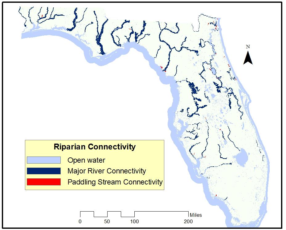
6 Riparian Connectivity
7 Coastal-Inland Connectivity

8 Xeric Habitat Connectivity
9 Bear/Panther Corridors and Hubs

10 General Landscape Connectivity
11 Updated FEGN
12 FEGN Land/Water Category Stats Land Use Category Acres Open Water 2,072,653 Existing Conservation Lands 9,706,439 Florida Forever Projects 1,822,274 Other Private Wetlands 2,963,792 Other Private Land 6,542,589 Total Acres 23,107,747

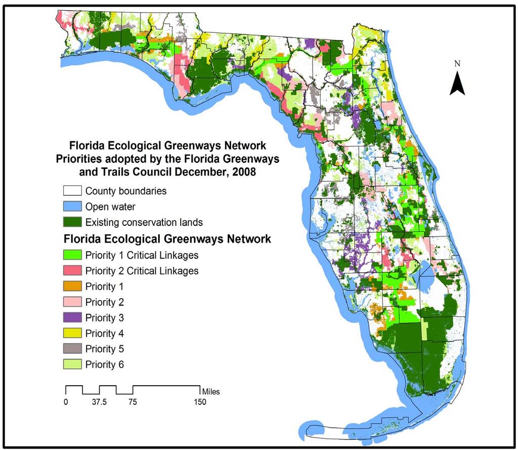
13 Current and New Draft FEGN Comparison
14 Current and New FEGN Comparison (terrestrial only) Description Acres In Both 19,030,153 In New FEGN Only 2,192,800 In Current FEGN Only 2,522,786
15

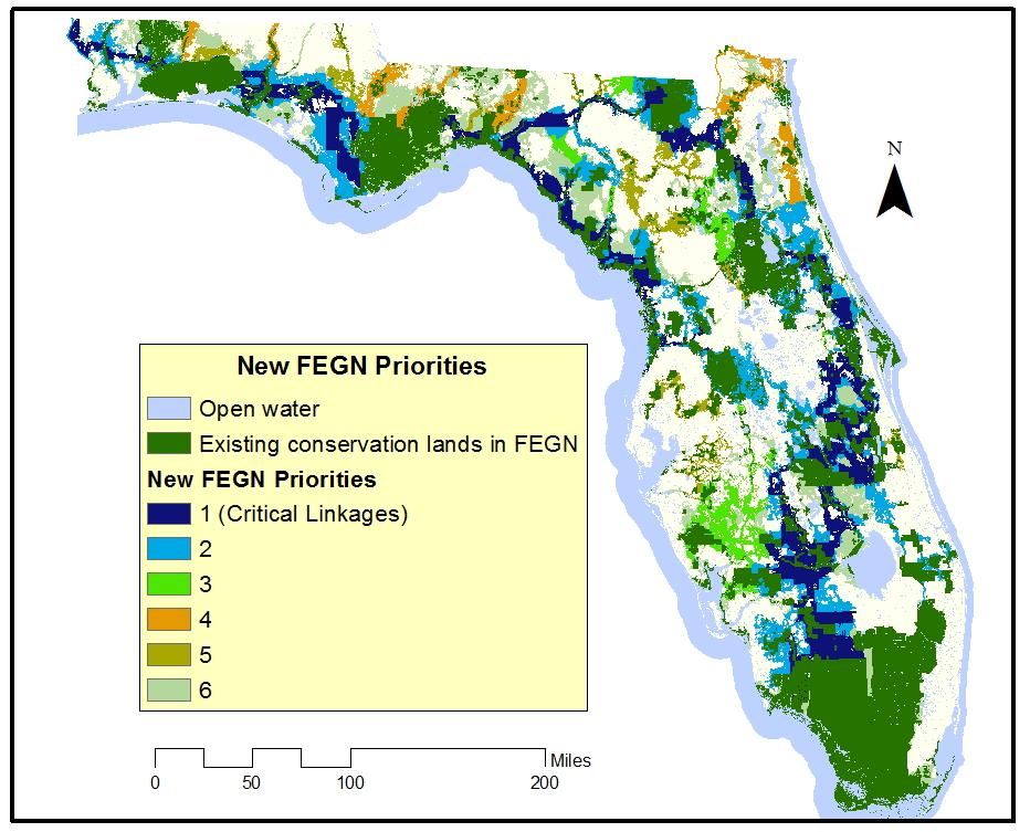
16 Assigned Prioritization to New FEGN Base Boundary
17 Prioritization Considerations: Future Development and Sea Level Rise Based on past FEGN prioritization work and the goals of the FEGN Update project, we used three primary considerations for any alterations to existing FEGN priorities: A new 2060 development projection from Zwick and Carr (UF) updated for the concurrent statewide SLR impact assessment project. Comparison of the new FEGN and assigned priorities to Lidar-based DEM sea level rise projections. Considerarion of merging Critical Linkages P1 and Critical Linkages P2 and the P1 and P2 classes to create six priority classes instead of the current eight classes.

18 Prioritization Considerations: FEGN and 2060 Growth Projection

19 Prioritization Considerations: FEGN High Priorities and 2060 Growth Projection

20 Prioritization Considerations: FEGN and Sea Level Rise

21 Prioritization Considerations: FEGN High Priorities and Sea Level Rise
22 Potential FEGN Prioritization Edits Proposed edits to the FEGN priorities include: 1) Consider merging Critical Linkages P1 and Critical Linkages P2 and the P1 and P2 classes to create six priority classes instead of the current rent eight classes. 2) Expand the St. Marks Critical Linkage to address SLR south of Tallahassee. 3) Consider Critical Linkage or at least P3 status for corridor that circles Tallahassee to the north (to serve as an alternate for St. Marks Critical Linkage). 4) Expand Coastal Big Bend Critical Linkage and consider elevating priority of inland Big Bend corridor to address SLR. 5) Consider expanding Critical Linkage around strategic areas of the St. Johns River to address potential sea level rise impacts. 6) Peace River from P3 to Critical Linkage to provide an additional option to connect south and north Florida. 7) Kissimmee to Green Swamp (Four Corners) corridor from P1 to Critical C Linkage to provide an additional option to connect south and north Florida. 8) Consider assigning higher priority to south to north corridors s within north Florida that connect to areas of conservation significance in Georgia and Alabama.
23 FEGN Update Prioritization
24 FEGN High Priority Stats Land Use Category FEGN Priority Level Acres Open Water Priority 1 (Critical Linkage) 1,078,086 Existing Conservation Lands Priority 1 (Critical Linkage) 7,278,356 Florida Forever Projects Priority 1 (Critical Linkage) 939,537 Other Private Wetlands Priority 1 (Critical Linkage) 669,474 Other Private Land Priority 1 (Critical Linkage) 1,465,675 Open Water Priority 2 266,906 Existing Conservation Lands Priority 2 1,102,105 Florida Forever Projects Priority 2 450,427 Other Private Wetlands Priority 2 769,167 Other Private Land Priority 2 1,799,252

25 Proposed Tallahassee Greenbelt P3 Corridor St. Marks River option in red; ; Aucilla River option in blue

26 Proposed Big Bend Critical Linkage Expansion Coastal expansion option in red; Interior Critical Linkage option Proposed Big Bend Critical Linkage Expansion in blue; ; Suwannee River corridor option in yellow

27 Proposed Middle St. Johns River Critical Linkage Expansion Potential area of expansion of the middle St. Johns River portion of this Critical Linkage in red

28 Proposed Peace River Corridor Critical Linkage Potential Peace River Critical Linkage in pink though some of the fringe areas would likely not be included.

29 Proposed Four Corners Critical Linkage Potential Four Corners Critical Linkage in pink though some of the fringe areas would likely not be included.

30 Proposed Florida to Georgia and Alabama Corridors Potential Florida to Alabama or Georgia corridor options in pink; St. Mary s s River in northeast Florida is another option not depicted on this map.
31 FEGN Update Prioritization
Southwest Florida Water Management District Conservation Land Acquisition Project Boundary Review Ecological GIS Decision Support System Final Report
 Southwest Florida Water Management District Conservation Land Acquisition Project Boundary Review Ecological GIS Decision Support System Final Report Introduction By: Tom Hoctor, Ph.D. Director, Center
Florida Forever Conservation Needs Assessment Overview Maps
 Florida Forever Conservation Needs Assessment Overview Maps Prepared by Florida Natural Areas Inventory, The maps in this document are derived from the Florida Forever Conservation Needs Assessment, an
Updating the Florida Ecological Greenways Network
 Updating the Florida Ecological Greenways Network FWC Agreement: 10066 Final Report Date Submitted: July 15, 2013 Dates Covered: July 1, 2010- June 30, 2013 Prepared by: Dr. Tom Hoctor, Conservation Trust
Wide-ranging Species Conservation
 Wide-ranging Species Conservation The overwhelming message from population viability studies of large carnivores is that conservation planning must be undertaken at vast spatial scales and must consider
ROLE OF LANDSCAPE CONSERVATION COOPERATIVES IN EVERGLADES RESTORATION
 ROLE OF LANDSCAPE CONSERVATION COOPERATIVES IN EVERGLADES RESTORATION GEER April 2017 Steve Traxler 1, Todd Hopkins 1, Beth Stys 2 1 US Fish and Wildlife Service 2 Florida Fish & Wildlife Conservation
Heartland Ecological Assessment Report. June 2010
 Heartland Ecological Assessment Report June 2010 photos by Carlton Ward Jr. Technical Advisory Group participants Hilary Swain, Roberta Pickert Archbold Biological Station Paul Gray Audubon of Florida
Photo by Carlton Ward Jr. Executive Summary
 Photo by Carlton Ward Jr. Executive Summary The Cooperative Conservation Blueprint (Blueprint) is a multi-partner strategic conservation process developed by the Florida Fish and Wildlife Commission (FWC)
Office of Greenways & Trails Providing Statewide Leadership and Coordination. Southeast Greenways and Trails Summit October 1-3, 2017
 Office of Greenways & Trails Providing Statewide Leadership and Coordination Southeast Greenways and Trails Summit October 1-3, 2017 1 Office of Greenways and Trails The Office of Greenways and Trails
Figure 1. Proposed Strategic Habitat Conservation Areas for Florida
 Figure 1. Proposed Strategic Habitat Conservation Areas for Florida Critical Lands and Waters Identification Project (CLIP) Cooperative Effort Century Commission for Sustainable Florida Florida Natural
October 28, May 25, 2010
 October 28, 2009 May 25, 2010 Jim Farr Staff Director, Acquisition and Restoration Council Office of Environmental Services Division of State Lands Florida Department of Environmental Protection 3900 Commonwealth
An Update on the Air Force Pilot Project: Developing the Florida Strategic Plan for Sustaining Military Readiness through Conservation Partnerships
 An Update on the Air Force Pilot Project: Developing the Florida Strategic Plan for Sustaining Military Readiness through Conservation Partnerships 18 November 2015 Quick Overview Pilot Project Background
Peninsular Florida Landscape Conservation Cooperative. Marine and Estuarine Priority Resources and Conservation Targets
 Peninsular Florida Landscape Conservation Cooperative Marine and Estuarine Priority Resources and Conservation Targets Why are we here today? Workshop Goals: Develop a list of potential conservation targets
RECREATION, OPEN SPACE AND GREENWAYS ELEMENT GOALS, OBJECTIVES, AND POLICIES
 RECREATION, OPEN SPACE AND GREENWAYS ELEMENT GOALS, OBJECTIVES, AND POLICIES GOAL R-1: DEVELOP A RECREATION, OPEN SPACE AND GREENWAYS SYSTEM AS AN INTEGRAL COMPONENT OF AN OVERALL, COUNTY-WIDE ECONOMIC
Surrey Ecosystem Management Study
 Surrey Ecosystem Management Study Green Infrastructure Network Opportunities Public Open House & Information Session June 24 th, 2010 EMS Process Ecological Inventory Ecological Assessment Management Policy
SUNBRIDGE PARKWAY PRELIMINARY DESIGN STUDY. November 30, 2017
 SUNBRIDGE PARKWAY PRELIMINARY DESIGN STUDY November 30, 2017 Agenda Introductions and Overview Study Purpose Study Approach Key Analysis Components Study Context Existing Conditions Corridor Constraints
North Ranch Master Plan
 North Ranch Master Plan Presentation to: East Central Florida Corridor Task Force Presentation by: Osceola County Office of Strategic Initiatives and Deseret Ranches Planning Team Kissimmee, Florida Friday,
Landscape Conservation Design April, 2014
 Designing Sustainable Landscapes in the Northeast A project of the North Atlantic Landscape Conservation Cooperative & Northeast Climate Science Center Landscape Conservation Design April, 2014 Conceptual
Identifying a Linked Reserve System Using a Regional Landscape Approach: the Florida Ecological Network
 Identifying a Linked Reserve System Using a Regional Landscape Approach: the Florida Ecological Network THOMAS S. HOCTOR,* MARGARET H. CARR, AND PAUL D. ZWICK *Department of Wildlife Ecology and Conservation,
Countywide Green Infrastructure
 Montgomery County s Countywide Green Infrastructure F U N C T I O N A L M A S T E R P L A N The Maryland National Capital Park and Planning Commission INFRASTRUCTURE An underlying base or foundation especially
GIS to Estimate Archaeological Site Loss and Develop Conservation Strategies
 GIS to Estimate Archaeological Site Loss and Develop Conservation Strategies Terry Jackson Office of Decision Support Systems Planning and Environmental Management Division Georgia Department of Community
Land Use and Management Plan Potts Preserve. Executive Summary
 Land Use and Management Plan Potts Preserve August 2011 Table of Contents... 1 Potts Preserve at a Glance... 1 Planning Process... 2 and... 6 Resource Protection and Security Program... 6 Public Use Program...
Florida s Ecological Network
 Case Study Series Florida s Ecological Network Photo by Jane M. Rohling / USFWS Vision "In the 21st century, Florida has a protected system of greenways that is planned and managed to conserve native landscapes,
Section 1 TABLE OF CONTENTS
 Section 1 TABLE OF CONTENTS... [M]ineral fertilizer is essential to feed around half of the world s population, and will be fundamental to ensure global food security through the 21 st century. 2013 U.N.
A Joined-up Regional Landscape: A Roadmap to connect the parts
 Breaking the Barriers: Engineering Solutions to Ecological Problems A Joined-up Regional Landscape: A Roadmap to connect the parts Associate Professor Darryl Low Choy Urban Research Program Outline Nature
Map Development 5/15/2012. New Virginia Modeling Tools
 Regional Green Infrastructure Base Map Development 5/15/2012 RRRC Land Use & Environment Committee New Virginia Modeling Tools VA Natural Landscape Assessment Forest Habitats Cultural Model Historic Resources
Chapter 5: Natural Resources and Environment
 NATURAL RESOURCES AND ENVIRONMENT 5-1 5 Chapter 5: Natural Resources and Environment BACKGROUND AND INTENT Urban expansion represents the greatest risk for the future degradation of existing natural areas,
Blue/Green Infrastructure Study Accomack County, VA
 Blue/Green Infrastructure Study Accomack County, VA Draft Asset Maps March 8-9, 2010 Green Infrastructure Center, Inc. 2 Overview What is Green and Blue Infrastructure Project Timeline & Tasks Literature
Florida s Evolving Large-scale Ecological Greenways S ystem. basis for a proposed ecological greenway connecting two large conservation areas.
 Florida s Evolving Large-scale Ecological Greenways S ystem By Doug Alderson & Dan Pennington The female adult bear paused while ambling through the Osceola National Forest. She raised her head and sniffed.
CURRICULUM VITAE. Thomas Scott Hoctor, Ph.D.
 CURRICULUM VITAE Thomas Scott Hoctor, Ph.D. Director of the Center for Landscape Conservation Planning Research Associate Professor College of Design, Construction and Planning University of Florida Research
INTEGRATING PROTECTION OF ECOSYSTEM SERVICES INTO THE PLANNING PROCESS IN FLORIDA
 INTEGRATING PROTECTION OF ECOSYSTEM SERVICES INTO THE PLANNING PROCESS IN FLORIDA Clay Henderson Institute for Water and Environmental Resilience - Stetson University Elizabeth Porter Economics Department,
Integration of Planning & Environmental Analysis in Transportation
 Integration of Planning & Environmental Analysis in Transportation How Natural Resources Conservation Fits into SAFETEA-LU Planning Rules Transportation Research Board Annual Meeting January 2008 Jeff
2014 South Atlantic LCC
 2014 South Atlantic LCC Annual Report 1 Allie Stewart, U.S. FWS The South Atlantic LCC s 2014 Annual Report this year of progress and accomplishments is dedicated to South Atlantic LCC Coordinator, Ken
Landscape Conservation Design June, 2014
 Designing Sustainable Landscapes in the Northeast A project of the North Atlantic Landscape Conservation Cooperative & Northeast Climate Science Center June, 2014 Adaptive Establish Conservation Goals
Conservation Corridor Planning and Green Infrastructure Themes
 Conservation Corridor Planning and Green Infrastructure Themes Prepared by the Green Infrastructure Center Inc. and the Northern Virginia Regional Commission February 22, 2011 Brief Overview Project Background
CURRICULUM VITAE. Thomas Scott Hoctor, Ph.D.
 CURRICULUM VITAE Thomas Scott Hoctor, Ph.D. Director of the Center for Landscape Conservation Planning Research Associate Professor College of Design, Construction and Planning University of Florida Research
CURRICULUM VITAE. Thomas Scott Hoctor, Ph.D.
 CURRICULUM VITAE Thomas Scott Hoctor, Ph.D. Director of the Center for Landscape Conservation Planning Research Associate Professor College of Design, Construction and Planning University of Florida Research
Bristol Marsh Heritage Conservancy
 Bristol Marsh Heritage Conservancy The Pennsylvania Environmental Council (PEC) protects and restores the natural and built environments through innovation, collaboration, education and advocacy. PEC believes
Phase I Ecological Network Report Terms of Reference
 Phase I Ecological Network Report Terms of Reference INTRODUCTION In 2007, the City of Edmonton created a new Natural Area Systems Policy (C-531) and a strategic plan, Natural Connections. Together, these
CURRICULUM VITAE. Thomas Scott Hoctor, Ph.D.
 CURRICULUM VITAE Thomas Scott Hoctor, Ph.D. Director of the Center for Landscape Conservation Planning College of Design, Construction and Planning University of Florida Research Associate, GeoPlan Center
Florida s Ephemeral Ponds and Pond-Breeding Amphibians
 Florida s Ephemeral Ponds and Pond-Breeding Amphibians What are Ephemeral Ponds? Ephemeral ponds are small, isolated wetlands that dry periodically. These ponds can be deep, sand-bottomed depressions with
Collaborative Conservation across Landscapes: Experiences from the Upper Midwest and Great Lakes LCC 2/29/2016. GreatLakesLCC.org
 Collaborative Conservation across Landscapes: Experiences from the Upper Midwest and Great Lakes LCC 2/29/2016 GreatLakesLCC.org Personal introduction Brad Potter - Science Coordinator for the Upper Midwest
Lake O the Pines Master Plan Revision Public Information Meeting April 25 & 27, 2017
 Lake O the Pines Master Plan Revision Public Information Meeting April 25 & 27, 2017 Presented By Matthew Like, Lake Manager U.S. Army Corps of Engineers Fort Worth District US Army Corps of Engineers
CONSERVATION ELEMENT. LISTED SPECIES Those species designated as endangered, threatened, or of special concern.
 CONSERVATION ELEMENT Definitions: LISTED SPECIES Those species designated as endangered, threatened, or of special concern. PROTECTED Refers to official federal, state, or internationally treaty lists
systems is available on the Colorado Wetland Information Center (CWIC) website.
 website.") Colorado Natural Heritage Program Wetland Program Plan -- Dec 2015 Status Update and Addendum -- The Colorado Natural Heritage Program (CNHP) developed a Wetland Program Plan (WPP) in 2010 for the planning
Colorado Natural Heritage Program Wetland Program Plan -- Dec 2015 Status Update and Addendum -- The Colorado Natural Heritage Program (CNHP) developed a Wetland Program Plan (WPP) in 2010 for the planning
Planning for Staten. Habitat Restoration and Green Infrastructure. Island s North Shore
 Habitat Restoration and Green Infrastructure Planning for Staten Island s North Shore Community Board 1 March 1, 2018 NYC Parks Forestry, Horticulture, and Natural Resources Funded by the NYS Department
DRAFT MAP AMENDMENT FLU 04-4
 DRAFT MAP AMENDMENT FLU 04-4 SW 24 TH AVENUE ROADWAY CORRIDOR The University of Florida participates with the Metropolitan Transportation Planning Organization (MTPO) in its responsibilities for the continuing,
G A R Y G R E E N L I N K APPENDIX A
 G A R Y G R E E N L I N K M A S T E R P L A N 1 American Bridge Property data American Bridge Property Manager 2 Little Calumet-Galien River Watershed Study Applied Ecological Services, Inc. 3 Final Assessment
EACCS Goal: provide guidelines for mitigation practices and overall conservation in east Alameda County
 EAST ALAMEDA COUNTY CONSERVATION STRATEGY: A BLUEPRINT FOR ACTION Community Meeting June 11, 2009 Agenda Welcome and Introductions Project Update o Introduction o Progress to Date o Next Steps Perspectives
Brockton. Produced in This report and associated map provide information about important sites for biodiversity conservation in your area.
 CONSERVING THE BIODIVERSITY OF MASSACHUSETTS IN A CHANGING WORLD Brockton Produced in 2012 This report and associated map provide information about important sites for biodiversity conservation in your
New Jersey Habitat Connectivity Project
 Mapping Core Team Meeting Two January 25 th, 10 am - noon Assunpink Wildlife Management Area, Main Office Meeting attendees: Patrick Carr, Margaret Conroy, Karl Figueiredo, Gretchen Fowles, Gylla MacGregor,
Land Corridors in the Southeast USA: Connectivity to Protect Biodiversity and Ecosystem Services
 Journal of Conservation Planning Vol 4 (2008) 90 122 Topics in Conservation Planning Not Peer Reviewed Land Corridors in the Southeast USA: Connectivity to Protect Biodiversity and Ecosystem Services Thomas
Making Space for Nature A Leicester Case Study. Dr Helen O Brien Leicester City Council
 Making Space for Nature A Leicester Case Study Dr Helen O Brien Leicester City Council Helen.Obrien@Leicester.gov.uk Definitions Biodiversity (biological diversity) The variety of plant and animal life
Great Lakes Conservation Blueprint for Terrestrial Biodiversity on the Canadian Shield
 Great Lakes Conservation Blueprint for Terrestrial Biodiversity on the Canadian Shield Bonnie L. Henson 1, Kara E. Brodribb 2 and John L. Riley 3 1 Ontario Ministry of Natural Resources 2,3 The Nature
Sustainable Natural Environment Wetlands
 Town of Huntsville Official Plan Review - POLICY BACKGROUND PAPER Sustainable Natural Environment Wetlands BACKGROUND: Wetlands are an important natural resource. The ecological, social and economic benefits
I ll be talking about the Designing Sustainable Landscapes project today. This is a large integrated modeling effort our group at UMass has been
 1 I ll be talking about the Designing Sustainable Landscapes project today. This is a large integrated modeling effort our group at UMass has been working on for the past 5 years, in close collaboration
Section 4 BUILDING THE MASTER PLAN
 The Master Plan 33 Section 4 BUILDING THE MASTER PLAN Figure 4:1. A collaborative effort characterized the two design workshops sponsored by DISC to create hypothetical Master Plans for the Towers Property
Conservation Corridor Base and Thematic Maps
 Conservation Corridor Base and Thematic Maps August 20, 2010 This project is funded in part by the Virginia Coastal Zone Management Program at the Department of Environmental Quality through Grant #NAO9NOS4190163
GEORGETOWN RIVERFRONT PARK FCT FF8
 MANAGEMENT PLAN GEORGETOWN RIVERFRONT PARK FCT 08-020-FF8 AUGUST 2010 PUTNAM COUNTY TABLE OF CONTENTS PAGE I. INTRODUCTION 3 II. PURPOSE.4 III. NATURAL AND CULTURAL RESOURCES..6 IV. SITE DEVELOPMENT AND
3-2 Environmental Systems
 3-2 Environmental Systems 3.0 ENVIRONMENTAL SYSTEMS CONTENTS 3.1 GREENWAY SYSTEM 3.1.1 General Policies 3.1.2 Natural Heritage Network 3.1.3 Natural Heritage Network Enhancement Lands 3.1.4 Rouge Watershed
LANDSCAPE ARCHITECTURAL DESIGN: PROCESS, PREDILECTIONS, AND PRIORITIES
 LANDSCAPE ARCHITECTURAL DESIGN: PROCESS, PREDILECTIONS, AND PRIORITIES ECOLOGICAL DESIGN IN THE SOUTHEAST APRIL 23, 2014 DR. JON CALABRIA, ASLA ASSISTANT PROFESSOR, COLLEGE OF ENVIRONMENT AND DESIGN, UNIVERSITY
The Landscape Project. New Jersey Department of Environmental Protection Division of Fish and Wildlife Endangered and Nongame Species Program
 The Landscape Project New Jersey Department of Environmental Protection Division of Fish and Wildlife Endangered and Nongame Species Program New Jersey is One of the smallest states in the country Yet
319 Grant: Baker Creek & Centenary Creek Restoration Initiative
 319 Grant: Baker Creek & Centenary Creek Restoration Initiative Objectives: Overview of Watershed Characteristics: Discussion of Project Tasks: Discussion of Watershed Management Plan: Presented by: Erich
Resiliency Initiative (based on TNC Terrestrial Resilience) Open Space Institute - - March; webinar
 Open Space Institute - - March; webinar") HOUSEKEEPING Notes Recent/upcoming meetings related to connectivity: DEP Commissioner update - - March Division of Fish and Wildlife regional meetings - - March NJ Land Conservation Rally --March Resiliency
HOUSEKEEPING Notes Recent/upcoming meetings related to connectivity: DEP Commissioner update - - March Division of Fish and Wildlife regional meetings - - March NJ Land Conservation Rally --March Resiliency
Aquatic, Terrestrial and Landscape Conservation Design Tools and Products of the North Atlantic LCC
 Aquatic, Terrestrial and Landscape Conservation Design Tools and Products of the North Atlantic LCC Scott Schwenk Science Coordinator, North Atlantic LCC Chesapeake Bay FWS Partners Meeting Annapolis,
Mitchell Ranch South MPUD Application for Master Planned Unit Development Approval Project Narrative. Introduction
 Mitchell Ranch South MPUD Application for Master Planned Unit Development Approval Project Narrative Introduction Mitchell Ranch South is a proposed single family (detached) residential development on
Green Infrastructure and Coastal Community Resilience
 Florida Waterfronts Program Managers Meeting May 24, 2012 - Crystal River, FL Green Infrastructure and Coastal Community Resilience Rosalyn Kilcollins Coastal Training Program Coordinator Apalachicola
West Bay Parkway (Segment 2) Land Suitability Mapping Analysis Technical Memorandum
 Land Suitability Mapping Analysis Technical Memorandum") PROJECT DEVELOPMENT AND ENVIRONMENT STUDY West Bay Parkway (Segment 2) Technical Memorandum The proposed widening of CR 388 from SR 79 to SR 77 Bay County FPID: 424464-3-22-01 Prepared for: Florida Department
PROJECT DEVELOPMENT AND ENVIRONMENT STUDY West Bay Parkway (Segment 2) Technical Memorandum The proposed widening of CR 388 from SR 79 to SR 77 Bay County FPID: 424464-3-22-01 Prepared for: Florida Department
Prioritizing Tidal Wetlands: A Landscape Approach
 Prioritizing Tidal Wetlands: A Landscape Approach Laura Brophy Director, Estuary Technical Group Institute for Applied Ecology Corvallis, OR College of Earth, Ocean and Atmospheric Sciences, Oregon State
Pontchartrain Coastal Lines of Defense Program Figure 1 Figure 2 Figure 1
 Pontchartrain Coastal Lines of Defense Program Coastal Sustainability Program February 2006 The Pontchartrain Coastal Lines of Defense Program consists of ten priority project areas within the Pontchartrain
Minnesota Department of Natural Resource - Natural Resource Guidance Checklist Conserving Natural Resources through Density Bonuses
 Minnesota Department of Natural Resource - Natural Resource Guidance Checklist Conserving Natural Resources through Density Bonuses NRDB Why Use Density Bonuses & This Checklist Local units of government
MAYFIELD WEST SECONDARY PLAN PHASE 2
 MAYFIELD WEST SECONDARY PLAN PHASE 2 Public Open House #3 February 25, 2010 Draft Preferred Land Use Scenario TOWN OF CALEDON PLANNING & DEVELOPMENT DEPARTMENT Open House Agenda TOWN OF CALEDON 1. Welcome
Incorporating Traditional Ecological Knowledge and Cultural Information Into Wetland Protection, Management, and Restoration - Tulalip Reservation
 Incorporating Traditional Ecological Knowledge and Cultural Information Into Wetland Protection, Management, and Restoration - Tulalip Reservation By Jonathan Hall, Wetland Biologist, Tulalip Tribes Weallup
SUNBRIDGE PARKWAY PRELIMINARY DESIGN STUDY. Board of County Commissioners Public Hearing
 SUNBRIDGE PARKWAY PRELIMINARY DESIGN STUDY Board of County Commissioners Public Hearing March 20, 2018 Presentation Overview Study Overview Existing Conditions Project Development Plan Public Involvement
Goleta Community Plan Update
 Goleta Community Plan Update Ecology, Biology, and Habitats GVPAC Meeting Agenda [Wednesday, December 17, 2008, 6:00PM] Pledge of Allegiance and Roll Call Public Comment Period Administrative December
Building Ecological Solutions to Coastal Community Hazards: Guidance and NJ Coastal Community Assistance
 Building Ecological Solutions to Coastal Community Hazards: Guidance and NJ Coastal Community Assistance Stacy Small-Lorenz National Wildlife Federation Restore America s Estuaries Summit New Orleans,
CITY OF ANN ARBOR MASTER PLAN. Land Use Element
 CTY OF ANN ARBOR MASTER PLAN Land Use Element June 15, 2009 Prepared by the Ann Arbor City Planning and Development Services Unit and the City of Ann Arbor Planning Commission City Master Plan: Land Use
AMENDMENT NO. 30 TO THE OFFICIAL PLAN OF THE TOWN OF MILTON
 AMENDMENT NO. 30 TO THE OFFICIAL PLAN OF THE TOWN OF MILTON Subject: Boyne Survey Secondary Plan and Related Official Plan Amendments The following text and schedules constitute Amendment No. 30 to the
National Association of Conservation Districts. Kris Hoellen Vice President, Sustainable Programs The Conservation Fund September 19, 2013
 National Association of Conservation Districts Kris Hoellen Vice President, Sustainable Programs The Conservation Fund September 19, 2013 Our Mission The Conservation Fund forges partnerships to conserve
Appendix H ETDM Screening Results Meeting Minutes
 Appendix H ETDM Screening Results Meeting Minutes RECORD OF MEETING - DRAFT SR 7 Corridor Extension PD&E Study FPID No. 229664-2-22-01 ETDM #8127 SUBJECT: ETDM Screening Results Meeting DATE AND TIME:
Appendix Q. Baseline Biology Report
 Appendix Q Baseline Biology Report A u g u s t 2 0 1 4 (DRECP) Baseline Biology Report Prepared for: California Energy Commission 1516 Ninth Street Sacramento, California 95814 Under Contract to: Aspen
Key Elements of Successful Conservation Planning. John Paskus October 17, 2013 Pierce Cedar Creek Institute Michigan Natural Features Inventory
 Key Elements of Successful Conservation Planning John Paskus October 17, 2013 Pierce Cedar Creek Institute Michigan Natural Features Inventory What is Conservation Planning? Pressey et al (2008): The process
CAO Update Status Work continues on products: Draft ordinance BAS report CAO process summary (2002 to present) Comprehensive e Plan policy review Some
 Comprehensive e Plan policy review Some") Critical Areas Ordinance Update Wetlands Andrew Deffobis Jeremy Davis Cynthia Wilson Thurston County Planning April 6, 2011 CAO Update Status Work continues on products: Draft ordinance BAS report CAO
Critical Areas Ordinance Update Wetlands Andrew Deffobis Jeremy Davis Cynthia Wilson Thurston County Planning April 6, 2011 CAO Update Status Work continues on products: Draft ordinance BAS report CAO
There are 11 different micro-ecosystems that are found in 76 different areas throughout Stoneybrook. They are divided into three major groups.
 by Larry Eichert There are 11 different micro-ecosystems that are found in 76 different areas throughout Stoneybrook. They are divided into three major groups. Wetlands Upland Mitigated sections (a term
Executive Summary. Essential Connectivity Map (Figure ES-1)
") Executive Summary The California Department of Transportation (Caltrans) and California Department of Fish and Game (CDFG) commissioned the because a functional network of connected wildlands is essential
Executive Summary The California Department of Transportation (Caltrans) and California Department of Fish and Game (CDFG) commissioned the because a functional network of connected wildlands is essential
DISCUSSION TOPIC: ST JOHNS RIVER & ITS TRIBUTARIES (BPII) 2030 COMPREHENSIVE PLAN POLICES AND REGULATORY FRAMEWORK
 2030 COMPREHENSIVE PLAN POLICES AND REGULATORY FRAMEWORK") DISCUSSION TOPIC: ST JOHNS RIVER & ITS TRIBUTARIES (BPII) 2030 COMPREHENSIVE PLAN POLICES AND REGULATORY FRAMEWORK St. John s River & Its Tributaries Issue Summary: The St. Johns River is an important
DISCUSSION TOPIC: ST JOHNS RIVER & ITS TRIBUTARIES (BPII) 2030 COMPREHENSIVE PLAN POLICES AND REGULATORY FRAMEWORK St. John s River & Its Tributaries Issue Summary: The St. Johns River is an important
Green Infrastructure Policies and Ordinances
 Green Infrastructure Policies and Ordinances October 23, 2013 By Karen Firehock, Green Infrastructure Center 2013 Georgia Urban Forest Council s 23 rd Annual Conference The mission of the nonprofit Green
CHATHAM COUNTY S PATH TO SUSTAINABILITY - THE NATURAL RESOURCES SIDE
 CHATHAM COUNTY S PATH TO SUSTAINABILITY - THE NATURAL RESOURCES SIDE GEORGIA ENVIRONMENTAL CONFERENCE SAVANNAH, GEORGIA AUGUST 23, 2012 Jackie Jackson Teel Chatham County-Savannah Metropolitan Planning
The Restoration of Reading Creek & Model Stream Buffer Ordinances/ Zoning Regulations for Alabama Streams
 The Restoration of Reading Creek & Model Stream Buffer Ordinances/ Zoning Regulations for Alabama Streams Charlene LeBleu, AICP, ASLA, Associate Professor of Landscape Architecture Auburn University Auburn,
What is the EDPA? The EDPA has three objectives: 1. Protect biodiversity. 2. Mitigate damage during development. 3. Restore degraded ecosystems
 What is the EDPA? Environmental Development Permit Areas are the best tool available to municipalities to protect ecosystems and habitat on private land. The EDPA has three objectives: 1. Protect biodiversity
4. What are the goals of the Kawarthas, Naturally Connected project? 7. What are watersheds and why are they being used as the project boundaries?
 Frequently Asked Questions (FAQs) 1. What are Natural Heritage Systems (NHS)? 2. Why are they important? 3. Which areas of the province have undertaken NHS projects? 4. What are the goals of the Kawarthas,
City of Surrey Ecosystem Management Study. Integration of ecological processes with land use
 City of Surrey Ecosystem Management Study Integration of ecological processes with land use Natural areas in Surrey are changing as the City grows and evolves. Many important natural areas remain or may
Middle Mississippi River. Regional Corridor
 Middle Mississippi River St. Louis District Regional Corridor Lessons Learned from a Collaborative Planning Study Brian Johnson US Army Corps of Engineers 12 th Biennial Governor s Conference on the Management
Florida Fish And Wildlife Conservation Commission
 Florida Fish And Wildlife Conservation Commission Division of Habitat And Species Conservation Invasive Plant Management Section Upland Invasive Exotic Plant Management Subsection Yet another year!!! Where
Call for Artists for: Design and Construction of Environmental Art Activation Story Mill Community Park, Bozeman, MT
 Call for Artists for: Design and Construction of Environmental Art Activation Story Mill Community Park, Bozeman, MT Seeking artists to design, fabricate and install art elements in the nature sanctuary
EC Conference on Green Infrastructure Green Infrastructure Applications in the U.S. Kris Hoellen, The Conservation Fund
 EC Conference on Green Infrastructure Green Infrastructure Applications in the U.S. Kris Hoellen, The Conservation Fund The Conservation Fund Partners in Land & Water Conservation Mission & Program Areas
PUBLIC NOTICE. us Anny Corps CENAE-R-A FILE NO. NAE
 CENAE-R-A FILE NO. NAE-2007-02926 PUBLIC NOTICE us Anny Corps of Engineers s. New England District 696 Virginia Road Concord, MA 01742-2751 Comment Period Begins: January 15, 2019 Comment Period Ends:
Category for Proposal: Partner Forums
 Project Title: Strategic conservation planning for management applications in Cascadia. Project Coordinator: Jen Watkins (Conservation Northwest, jwatkins@conservationnw.org) Project PIs: Cascadia Partner
Northeast Florida Estuary Restoration Initiative: A District Perspective. Ron Brockmeyer, SJRWMD And a cast of thousands!!
 Northeast Florida Estuary Restoration Initiative: A District Perspective Ron Brockmeyer, SJRWMD And a cast of thousands!! Success and Local Partners Impoundment Reconnection / Restoration (Merritt Island
Memorandum Planning. Thursday, January 8, 2015
 Memorandum Planning Thursday, January 8, 2015 7.A. To: Coastal Advisory Committee From John Ciampa, Associate Planner Subject: Review Draft Local Coastal Program Copies: James Pechous, City Planner Purpose
COLORADO S Comprehensive Wildlife Conservation Strategy Linking Conservation and Transportation Planning August 15, 2006
 COLORADO S Comprehensive Wildlife Conservation Strategy Linking Conservation and Transportation Planning August 15, 2006 The Input Process Input from DOW experts List of scientific experts Mailing to 1000