Heartland Ecological Assessment Report. June 2010
|
|
|
- Wendy Mariah Cunningham
- 6 years ago
- Views:
Transcription

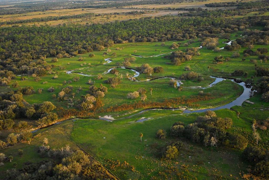
1 Heartland Ecological Assessment Report June 2010 photos by Carlton Ward Jr.
2 Technical Advisory Group participants Hilary Swain, Roberta Pickert Archbold Biological Station Paul Gray Audubon of Florida Pat Steed Central Florida Regional Planning Council Luis Gonzalez, Steve Lau Florida Fish and Wildlife Conservation Commission Margaret Barletto South Florida Water Management District Stephanie Green, Steve Dicks Southwest Florida Water Management District B Pace-Aldana, Keith Schue, Tricia Martin The Nature Conservancy Dan Smith University of Central Florida Steve Schubert, Mary Peterson, Charlie Pelizza U.S. Fish and Wildlife Service Contractors Tom Hoctor, Director, Center for Landscape and Conservation Planning, Research Associate, GeoPlan Center Department of Landscape Architecture, University of Florida Michael O'Brien, graduate student, University of Florida School of Landscape Architecture and Planning Jon Oetting, Conservation Planner, Florida Natural Areas Inventory (FNAI) Report prepared by The Nature Conservancy, Babson Park, FL i
3 Table of Contents Executive Summary... 4 Heartland Overview... 6 Explanation of Data Layers... 7 Matrix of Priority Conservation Resources by Land Use Category... 7 Florida Black Bear Habitat... 9 Florida Panther Habitat Riparian Greenways Ecological Network Groundwater Priorities Smokesheds Data layers with no Figures Rare Species Habitat Conservation Priorities Riparian Buffers Conservation Buffers Strategic Habitat Conservation Areas Natural Communities Greenways Wetlands Potential Natural Areas Landscape Integrity Literature Cited Figure Heartland Ecological Assessment Report 2
4 Figure Figure Figure Figure Figure Figure Figure Heartland Ecological Assessment Report 3
5 Executive Summary The Nature Conservancy convened a Technical Advisory Group (TAG) and contractors to assist the Central Florida Regional Planning Council in developing the ecological foundation for the Heartland 2060 regional visioning project. The Heartland 2060 multi-year effort will result in a vision statement expressing common values, a regional future growth plan, and an action plan to address regional priorities. We designed this study to help create a sustainable future for Florida s Heartland (Polk, Highlands, Glades, Desoto, Okeechobee, Hendry and Hardee counties). This report and the associated database synthesize the best available ecological data for this 7-county region. This information is intended to provide the best available science to help guide the Heartland 2060 visioning effort. The data is intended to be regional in scope not site specific. In crafting a vision for this region, it is essential to protect a functional landscape that will preserve critical ecosystem services and the viability of species and natural systems. This is an opportunity to be proactive and take into account these important ecosystem values (and our responsibilities as stewards of these resources) before they are compromised, requiring costly restoration or engineered solutions. The database includes a suite of ecological information that can be viewed as individual layers or combined with other layers. Select data layers are provided as figures in this report. The culmination of this study is the Conservation Strategies Matrix. The contractors developed this matrix (Table 1) to identify priority areas and propose different conservation approaches for natural and working lands. Areas identified in the highest levels of the natural category might be appropriately identified for fee title land acquisition programs; sites in the current working landscape category might be more appropriately identified as priorities for conservation easement or incentive programs. The methodology used to develop this matrix is described in the Explanation of Data Layers section. Heartland Ecological Assessment Report 4
6 Table 1. Conservation Strategy Matrix "Natural" "Working Landscapes" Priority 1 FNAIHAB P1 on natural landcover FNAIHAB P1 on seminatural SHCA P1 on natural landcover SHCA P1 on seminatural NC: Scrub and sandhill if on PNA 1-4,100 or LI 7-10 Riparian Buffers - Value 1 on seminatural NC: All dry prairie, seeps, SH upl lakes Panther - Value 9 on seminatural landcover (or other ag) Riparian Buffers - Value 1 on natural Bear - Values 9, 8 on seminatural landcover (or other ag) Panther - Value 9 on natural landcover Greenways: C1-2 on seminatural lancover Bear - Values 9, 8 on natural landcover Greenways: C1-2 on natural lancover Priority 2 FNAIHAB P2-3 on natural FNAIHAB P2-3 on seminatural SHCA P2-3 on natural SHCA P2-3 on seminatural NC: Rem. scrub and sandhill Greenways P1-3 on seminatural (or other ag) NC: All Seepage Slope/Bog and Trop. Hammock Smoke Buffers - Value 9 or 8 on seminatural landcover Greenways P1-3 on natural Riparian Buffers - value 2-3 on seminatural Panther - Value 7 and 8 on natural Panther - Value 7 and 8 on seminatural (or other ag) Bear - Value 7 on natural Bear - Value 7 on semi-natural (or other ag) Wetlands - all Conservation Buffers - Values 9, 8, or 7 on seminatural Smoke Buffers - Value 9 or 8 on natural landcover Conservation Buffers - Value 9, 8, 7 on natural Priority 3 FNAIHAB P4-6 on natural FNAIHAB P4-6 on seminatural SHCA P4-5 on natural SHCA P4-5 on seminatural NC: All upland hardwd forest and pine flatwoods Landscape Int P7-10 on seminatural Landscape Int P7-10 on natural Greenways P4-6/Riparian Greenways on seminatural Greenways P4-6/Riparian Greenways on natural Bear - Value 6, 5, 4 on seminatural (or other ag) Bear - Value 6, 5, 4 on natural Smoke Buffers - Values 6-7 on seminatural Panther - Value 6 and 5 on natural Panther - Value 6 and 5 on semi-natural (or other ag) Smoke Buffers - Values 6-7 on natural landcover Conservation Buffers - Value on seminaural FNAIHAB SHCA NC Riparian Buffers Panther Bear Greenways Wetlands Smoke Buffers Conservation Buffers PNA LI or Landscape Int. FNAI Rare Species Habitat Conservation Priorities FWC Strategic Habitat Conservation Areas Natural Community models UF priority buffers along riparian corridors UF panther model UF bear model UF/OGT Ecological Greenways Network WMD FLUCCS wetlands TNC conservation land smoke buffers conservation land buffers FNAI Potential Natural Areas UF Landscape Integrity model Heartland Ecological Assessment Report 5
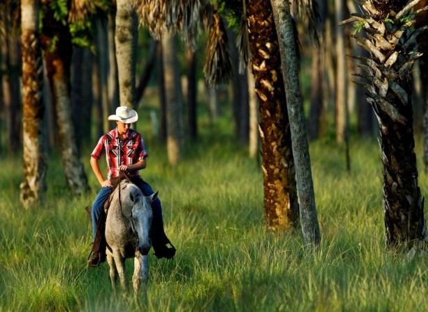
7 The information helps us understand where ecological priorities are located and what should be preserved to protect a healthy environment. This report identifies an ecological footprint for the region that seeks to minimize potential conflicts between land uses and helps to ensure that ecosystem functionality can be maintained as the region grows in a sustainable manner. The TAG focused on four main areas: protecting the biological diversity encompassed within this region; preserving the integrity of important water resources; examining management needs for conservation lands; and identifying regionally important ecological greenways, or corridors, for wildlife. Heartland Overview The ecological, agricultural, recreational and cultural attributes of the Heartland region are inextricably linked. A balanced approach is necessary for maintaining and growing a sustainable economy; protecting biodiversity and ecosystem services; and ensuring a high quality of life for residents and visitors. In crafting a vision for the region, Heartland 2060 must protect the ecological infrastructure that provides the foundation for a sustainable future. The region supports a large concentration of threatened and endangered species, high quality habitats, endemic natural communities and significant hydrological resources. It is an important region for long-standing conservation efforts (See Figure 1). The large ranches characteristic of the region are a cornerstone of this area s economy and heritage and play a critical role in maintaining its ecological integrity. Sustainable and viable agricultural are critical for the future of this region. A 10-mile buffer around the project area was included to encourage thinking about ecological connections with adjacent regions. Certain ecological goals stand out: Strengthening north/south functional connections for panthers, bears and other wideranging species. Creating a permanently protected network of functionally connected public and private conservation lands across the region. Protecting the unique and imperiled biodiversity of the region s scrub and prairie ecosystems. Heartland Ecological Assessment Report 6
8 Maintaining the ecological integrity of the high priority natural and working landscapes as identified in the Conservation Strategy Matrix. Creating compatible neighbors by minimizing potential conflicts between urban/suburban lands uses and conservation lands. Establishing, restoring and maintaining riparian networks and buffers. Public and private conservation entities have invested years of effort and millions of dollars to create an interconnected landscape through this region of the state. It is essential that we protect investments already made and that we connect and buffer conservation areas to create a functional, resilient landscape rather than a collection of fragmented sites. Explanation of Data Layers Matrix of Priority Conservation Resources by Land Use Category For the Heartland 2060 conservation priorities analysis, resources were grouped into three priority classes, with Priority 1 representing the highest priority for conservation. In addition to these priorities, we categorized resources by the intensity of land use that would be appropriate or compatible with those resources. Resources were grouped into two land use categories: Natural and Working Landscapes. The result is the Matrix of Priority Conservation Resources by Land Use Category (see Figure 2). The intent of this matrix is to acknowledge that areas important for conservation occur both within natural areas and on working landscapes. Not all natural resources must be acquired as conservation lands for the resources to persist. Many rural land uses of varying intensities are compatible with various natural resource conservation objectives. Some natural resources such as scrub, most wetlands, and various habitat specialist species (for instance, the Florida scrub-jay and many rare plant species) require the maintenance or restoration of natural cover or conditions. However, many natural resources and species can persist or remain viable in conjunction with some degree of human-influenced land uses. Therefore, resources included in the "Natural" land use category are those resources that require relatively pristine natural systems to function and persist long term. These include high quality natural communities and sensitive species habitat. For the purpose of this analysis, Heartland Ecological Assessment Report 7
9 we included most resource priority areas that currently exist on natural land cover. While some of these resources could potentially remain viable with some degree of human disturbance, natural land cover is highly preferable, especially for those resources in Priority 1 in the Matrix. Resources included in the "Working Landscapes" category are resources that are compatible with relatively low-intensity human land uses such as ranching. Assuming that best management practices are used, these land uses are considered to be compatible with the long term persistence of the identified resources. Overall, the focus of conservation efforts should be first to maintain current land uses, or even restore natural systems, across resources grouped as Priority 1. Ideally, Priority 2 and 3 resources are also important to the goal of maintaining current compatible land uses, although these resources are lower priority for maintaining the overall suite of ecosystem functions in the region. One important caveat to these very general guidelines is that areas important for protecting state and regional ecological connectivity incorporate both lands in the Natural and Working Landscape categories. It is important that ecological connections across natural and working landscapes be carefully considered to maintain and restore functional connectivity. However, with this said, working land uses such as ranches in the Heartland region are at least generally compatible with the goal of protecting regional ecological connectivity and should be treated as such in planning efforts in the region. Notes on the Modeling Process Note that there can be overlap between different resource types included in this analysis. In case of overlap, Priority 1 overrides Priority 2, which overrides Priority 3. As a result, lands that meet one or more criteria for Priority 2 or 3 may also be identified in Priority 1 criteria. (For example, an area might be a high priority for Rare Natural Communities but a low priority for the Florida Ecological Greenways Network. In this model this areas would still be an overall high priority because it is a high priority for at least one of the component resources. This is called this a rules-based combination where an area's priority is based on the highest priority received for any single input layer.) Natural and semi-natural land covers were classified from two primary land cover data sources. The base layer was the water management districts FLUCCS land Heartland Ecological Assessment Report 8
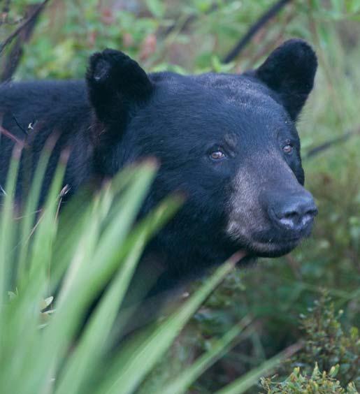
10 cover. However, where FNAI natural community models have been developed, they superseded the FLUCCS classification. Ideally, natural resources occurring on semi-natural land cover might undergo detailed examination to determine if some might in fact require a more natural landscape for long term persistence (i.e., some semi-natural areas should be restored to natural systems to maintain viability of resources on those lands). That level of analysis was beyond the scope of this project. 0 = not priority 1 = working landscape P3 2 = working landscape P2 3 = working landscape P1 4 = natural P3 5 = natural P2 6 = natural P1 Florida Black Bear Habitat The first major step in the process was to create a black bear habitat map for the study area. The Florida black bear potential habitat model was created using documented information about Florida black bear habitat preferences and assessment of connectivity thresholds based on distance from primary habitat and land use type (Maehr et al 2001, Hoctor 2003, Orlando 2003). Habitat was identified using Water Management District land-use data at a 10 meter cell size. Three types of habitat/land use were identified: 1) Primary habitat forest cover including flatwoods, hammocks, scrub, and forested wetlands. All patches of primary habitat greater than 6 hectares (approximately 15 acres) were identified (Cox et al. 1994). 2) Secondary habitat sandhills, shrub and brush, and freshwater shrub wetlands and freshwater herbaceous wetlands. Patches of secondary habitat or smaller Heartland Ecological Assessment Report 9
11 patches of primary habitat that are near larger primary habitat (15 acres and larger) can also be used by bears. However, patches separated by intensive land uses that cannot be reached or easily reached may not be used. Therefore, traversable matrix land cover and land uses were also identified to determine which secondary patches were functionally connected to primary patches. All secondary habitat types and all smaller patches of primary cover within 1.5 kilometers of primary patches and connected by traversable matrix were identified as potential habitat. 3) Traversable matrix almost all other land use types that bears are capable of moving through when proximal to primary habitat including agriculture, mining lands, and saltmarsh. Roads also were included to model habitat patches across roads that bears might be able to access (Larkin et al. 2004). Large water bodies were not included as potential habitat, but narrow channels that might be crossed were identified and included within the traversable matrix. Narrow water gaps were defined as <100 meters (Dave Maehr, personal communication). Then, all primary and secondary habitat were combined to identify connected blocks >10,000 acres. This was done to identify areas that are more likely to be large enough to serve as minimum functional habitat units for black bear (Hellgren and Maehr 1992). Within these areas, primary habitat was given a value of 1, secondary habitat was given a value of 2, and traversable matrix was given a value of 3. The second major step was to combine the black bear potential habitat map with areas representing occupied bear range or other habitat conservation priorities for black bear in the study area. The following data were used in this step: 1.) Florida Black Bear Strategic Habitat Conservation Areas from the Florida Fish and Wildlife Conservation Commission 2.) Primary and secondary bear range from the Florida Fish and Wildlife Conservation Commission Heartland Ecological Assessment Report 10
12 3.) Priority Bear Population Priority Conservation Areas identified by Tom Hoctor. These areas were identified using set of habitat and landscape variables relevant to identifying bear habitat with high integrity created under contract for the Florida Fish and Wildlife Conservation Commission in This model of habitat quality/integrity was then modified to give higher priority to areas near existing conservation areas within occupied bear range. Then, all habitat areas needed to secure a protected habitat base of at least 500,000 acres were identified for each Florida black bear population in Florida. 4.) A priority corridor connection south of Lake Kissimmee to connect priority bear habitat in Avon Park Air Force Range to Three Lakes Wildlife Management Area was also identified for this project. These four different priority areas were then combined into one dataset and combined with black bear potential habitat in the following fashion: 9 = Potential primary habitat within priority areas; priority 1 (highest) 8 = Potential secondary habitat within priority areas; priority 2 7 = Potential traversable matrix with priority areas; priority 3 6 = Other potential primary habitat; priority 4 5 = Other potential secondary habitat; priority 5 4 = Other potential traversable matrix; priority 6 1 = All other areas in the study area The reader should keep in mind that some areas are critical to achieving the ultimate objective of creating a connected network of protected lands that sustain a viable population of black bear. This means that areas of moderate bear habitat value (brown color) could become very important if they provide a vital linkage between higher priority habitat areas. Although this map of priority bear habitat (Figure 3) depicts a pretty robust corridor for bear movement north and south through the region, the Heartland Conservation Priorities map Heartland Ecological Assessment Report 11
13 shows almost all of this area as working priority lands. For these lands to actually remain viable for black bear, it will be important that the type of agriculture remain conducive to the species (and for these areas to not be severed by roads). For example, forested areas should remain as such to support the black bear, rather than be converted to other forms of agriculture that might support other wildlife, but not the Florida black bear. Florida Panther Habitat The first major step in the process was to create a Florida panther potential habitat map for the study area (See Figure 4). The Florida panther requires intact landscapes with no to low human activity dominated by land cover and land use that supports suitable cover and prey (Kautz et al. 2006, USFWS 2008). Various types of forest are of primary significance but panthers also use rural mosaics containing upland and wetland forest, herbaceous wetlands, dry prairies, pasturelands, and other agricultural land uses (Kautz et al. 2006, Land et al USFWS 2008). Panthers require large areas to support functional home ranges and the integrity of home ranges, with respect to impacts from roads and other human land use and activities, is an important consideration for maintaining or restoring suitable habitat (Kautz et al. 2006, USFWS 2008). The Florida panther habitat model applied in this study was adapted from the potential habitat model created by the Florida Fish and Wildlife Conservation Commission as part of their update to Strategic Habitat Conservation Areas ( The model was created using Water Management District land-use data at a 10 meter cell size to identify forest patches 2 hectares (approximately 5 acres) or larger and then adding all non developed (natural, semi-natural, agriculture) areas within 200 meters of such forest patches (Kautz et al. 2006). Forest patches 2 hectares or larger and all other habitats within 200 meters of these patches were all given a value of 1. Heartland Ecological Assessment Report 12
14 The second major step was to combine the Florida panther potential habitat map with areas representing habitat conservation priorities for panther in the study area. The following data were used in this step: 1. U.S. Fish and Wildlife Service (USFWS) Florida Panther Subteam Primary, Secondary, and Dispersal Conservation Zones 2. University of Tennessee Florida Panther Potential Habitat Priorities Analysis for the USFWS 3. Potential Florida Panther corridors identified by Tom Hoctor connecting Babcock Ranch to Myakka conservation lands complex, Avon Park Air Force Range, and Okaloachoochee Slough State Forest (Noss and Hoctor 2010) To start the combination of the Florida panther potential panther habitat and priority areas, we combined the Panther Subteam Primary and Dispersal Zones; University of Tennessee high, medium, low probability habitat areas; and potential panther corridors from the Babcock Ranch connectivity study. These priority areas were only retained if they also overlapped with panther potential habitat. Then we ran a connectivity analysis and retained only the areas that were connected together in a regional network of priority potential panther habitat. Finally, we combined this panther habitat network with other data to identify the following priority habitat values: 9 = Panther habitat network within Panther Subteam Primary and Dispersal Zones; priority 1 (highest) 8 = Panther habitat network within Panther Subteam Secondary Zone; priority 2 7 = Panther habitat network within University of Tennessee high and medium probability habitat areas; priority 3 6 = Panther habitat network within University of Tennessee low probability habitat areas; priority 4 5 = Panther habitat network within other panther potential habitat; priority 5 4 = University of Tennessee high probability habitat areas NOT within the panther habitat network; priority 6 Heartland Ecological Assessment Report 13
15 1 = All other areas in the study area As with the bear layer, the reader should keep in mind that some areas are critical to achieving the ultimate objective of creating a connected network of protected lands that sustain a viable population of panthers. This means that areas of moderate panther habitat value (brown color) could become very important if they provide a vital linkage between higher priority habitat areas. Riparian Greenways Since the Florida Ecological Greenways Network (FEGN) focuses on state and regional corridor priorities, there can be other significant corridors at the regional to local scale that are not included within the FEGN (Figure 5). Riparian networks including rivers, streams, lakeshores and associated wetlands, floodplains, and forests, are important landscape features used by many species. Therefore, any intact riparian corridors that might provide additional connectivity within the study area were identified. The riparian corridor layer was created by combining all forested wetlands from Water Management District land use data with streams from NHD flowlines data. Then we identified all additional natural or semi-natural land cover (defined as all FLUCCS values from 3000 to 7399) within 400 meters (half the corridor distance we would like to see at regional scales, but a good starting point for riparian based networks; Hoctor 2003) of these forested wetlands and streams. We then identified all parts of the FEGN in natural and semi-natural land use and combined these areas with riparian habitat. Finally, only areas of riparian habitat and/or FEGN in natural/semi-natural land use in swaths 1000 acres or larger were retained. Values are: 1 = Combined patches of intact FEGN and/or riparian habitat/corridors that are 1,000 acres or larger 0 = Not within these larger patches/corridors Heartland Ecological Assessment Report 14
16 Ecological Network This dataset was not used in the Natural Resources prioritization matrix, but it provides an explicit identification of priority areas for protecting a functionally connected network of public and private conservation lands across the study region. However, this identification of ecological connectivity priority areas is a regional-scale model that identifies general opportunities. In reserve design at the landscape or site scale, areas included might be modified and widths of corridors may need to be wider or could be made narrower than depicted here depending on the scale of the corridor, context, protection of functional buffers (including both hydrology and negative edge effects), and the focal species under consideration. With that said, the two most demanding species regarding required space, corridor width, and sensitivity to intensive human activities are the Florida panther and Florida black bear, and each of these species are the best candidates for serving to identify, design, restore, protect, and manage functional corridors and connectivity. This dataset was created by identifying all natural and semi-natural land uses within any of the following areas: the Panther Primary and Dispersal Zones, all high and medium probability areas in the University of Tennessee panther potential habitat model, all Florida black bear potential habitat, and Riparian Buffers (See Figure 6). These areas were then buffered by 400 meters and all other rural land uses within these buffers were also identified. Areas within the Integrated Habitat Network were also added included as either natural/semi-natural, other rural/agricultural, or more intensive land use categories depending on the overlaying land use. The values are: 1 = Natural/semi-natural land uses within the regional ecological network; priority 1 (highest) 2 = Rural/other agricultural land uses within the regional ecological network; priority 2 3 = Areas of more intensive land uses (mostly mining) within the Integrated Habitat Network; priority 3 Heartland Ecological Assessment Report 15
17 Groundwater Priorities We reclassified the Groundwater priorities map from the Florida Forever Needs Assessment to identify areas important for protecting groundwater resources (See Figure 7). These resources are potentially compatible with moderate or even high intensity land uses, if potential impacts to the resources are carefully considered and appropriate design, mitigation, and management practices are used. For example, a variety of land uses can potentially occur on high recharge areas, as long as the quality and quantity of water being recharged to groundwater aquifers is minimally impacted. One of the legislatively stated goals of the Florida Forever program is to acquire acres of groundwater recharge critical to springs, sinks, aquifers, other natural systems or water supply. In order to develop a means of identifying these areas, Florida Natural Areas Inventory subcontracted with Advanced Geospatial, Inc. (AGI) to develop a statewide Recharge Potential model. Input data layers for the model were consistent with those used in the Florida Aquifer Vulnerability Assessment (FAVA) developed by the Florida Geological Survey and consisted of soil hydraulic conductivity, proximity to karst features, depth to water, and overburden. These input layers were combined using a spatial analysis called Fuzzy Logic. Detailed documentation for the base model may be found in AGI's final report, "FNAI- Recharge Component, 2009". The AGI model is a statewide grid of 300 x 300m cells, with cell values ranging from 0-1 on a continuous scale. The continuous values allow for flexibility in how the model is applied. For Florida Forever reporting and evaluation it was necessary to group the values into several priority classes, ranging from high to low, to help focus on the most important places statewide to protect significant recharge areas. The prioritization also addresses the intent of Florida Forever to acquire recharge areas important for springs and water supply. FNAI consulted with AGI, Florida Geological Survey and DEP to accomplish this prioritization. For more details please refer to the Florida Forever Conservation Needs Assessment Technical Report version 3.2, available online at The final Prioritized Recharge dataset is a 30m grid with 6 priority classes. Heartland Ecological Assessment Report 16
18 1 = Priority 1 (Highest) 2 = Priority 2 3 = Priority 3 4 = Priority 4 5 = Priority 5 6 = Priority 6 Smokesheds This shapefile consists of smokesheds for the existing fire-dependent conservation lands within Heartland 2060 region (See Figure 8). To avoid conflicting land uses, The Nature Conservancy developed the smokeshed data layer to serve as a land-use planning tool that provides guidance for the best locations of new development to minimize smoke impact from prescribed fires. It is important to note that this model does not map smoke buffers for agricultural lands that also rely on prescribed burning. If additional lands are acquired, this data layer will need to be updated. The smokeshed areas are classified into four stacked buffer zones extending outward from conservation boundaries up to 2 mi. The buffer zones are numbered 1 through 4, reflecting increasing suitability for development types of greater smoke sensitivity (i.e., development types of greater smoke sensitivity are limited to zones of higher value than are development types of lesser smoke sensitivity). To preserve the smokesheds, land-use planners would allow new roads, road expansions, and developments only within the appropriate buffer zones (Table 1). For example, a new hospital should occur only within an area classified as buffer zone 4; a new local-rural road should be sited within a buffer zone 2 or higher. The distribution of smoke-sensitive development types among the four buffer zones is determined by a set of minimum distance criteria (Table 2) from conservation boundaries. The development types consist of roads by Florida Department of Transportation (FDOT) functional Heartland Ecological Assessment Report 17
19 class, hospitals, nursing homes, airports and other aviation sites, and commercial, residential, and industrial areas. These criteria were developed by Nature Conservancy fire managers and reviewed by land managers of Lake Wales Ridge conservation sites. Table 2. Minimum distance criteria for smoke sensitive development. FDOT Road Class Description Distance from Conservation Boundary 6 minor arterial -rural > 0.25 mile 2, 3, 4 8 minor collector - rural > 0.25 mile 2, 3, 4 9 local - rural > 0.25 mile 2, 3, 4 1 principal arterial - > 0.5 mile 3, 4 interstate, rural 2 principal arterial - > 0.5 mile 3, 4 other, rural 7 major collector - rural > 0.5 mile 3, 4 16 minor arterial - urban > 0.5 mile 3, 4 17 collector - urban > 0.5 mile 3, 4 19 local - urban >0.5 mile 3, 4 11 principal arterial - > 1 mile 4 interstate, urban 12 principal arterial - freeways\ expressways, urban > 1 mile 4 Smokeshed Buffer Zone(s) 14 other principal arterial - urban Other land use types > 1 mile 4 residential\commercial\ industrial > 0.25 mile 2, 3, 4 hospitals \ nursing homes > 1 mile 4 airports, airstrips, heliports > 2 miles outside of smokesheds To identify the smokesheds, a land-use analysis was conducted using ArcGIS Spatial Analyst's cost-weighted distance tool. Road data was obtained from the Florida Department of Heartland Ecological Assessment Report 18
20 Transportation; airport, hospital and nursing home locations were obtained from the Florida Geographic Data Library ( commercial, industrial, and residential areas were digitized from the latest DOQQ imagery available from each county; conservation area boundaries were provided by the Florida Natural Areas Inventory, The Nature Conservancy, Archbold Biological Station, and Polk County Environmental Lands Program. The default maximum buffer zone widths are 0.25 mi, for each of buffer zones 1 and 2, 0.5 mi for buffer zone 3, and 1 mi for buffer zone 4. Where developments occur at less than the minimum recommended distances, the category, location, and width of the buffer zones are determined by the existing development types and their distances from the nearest conservation edge. For example, where residential, commercial, or industrial area occurs immediately adjacent to a conservation boundary, the area is classified as a zone 2 at best. Where there are no developments extending at a perpendicular distance from a conservation edge or where all developments are at or exceed the recommended distances, the buffer zones are at their full width from the nearest conservation boundary. Areas where smokesheds are compromised by smoke-sensitive development in too close proximity may have one or more buffer zones narrower than the maximum width or may be missing one or more zones all together. In these cases, the area is still crucial for protection from further deterioration because they still function as part of smokesheds for areas up to two miles away within the conservation boundary. Data layers with no Figures All of the following data layers were used in the Conservation Strategy Matrix. Separate figures are not provided in this report. Heartland Ecological Assessment Report 19
21 Rare Species Habitat Conservation Priorities This data layer was created by FNAI as part of the Florida Forever Conservation Needs Assessment, a statewide analysis of natural resource conservation priorities for the Florida Forever statewide environmental land acquisition program. The model was explicitly designed to identify areas important for species habitat based on both species rarity and species richness. This data layer closely reflects the conservation priorities of FNAI and the rare species and natural communities we track. FNAI mapped occurrence-based potential habitat for 248 species of plants, invertebrates, and vertebrates, including aquatic species. Because land acquisition was the focus, species were included according to their need for additional habitat placed in conservation. All federally listed species were included, as well as many state listed species and several rare species not listed at either the federal or state levels. Suitable habitat was mapped only in the vicinity of known occurrences so that lands acquired because of these priorities are assured of protecting a known population of the species. Riparian Buffers Riparian buffers were identified by starting with NHD Flowlines data modified by the Florida Fish and Wildlife Conservation Commission to improve its accuracy. Then all ditches were removed from the flowline data, which included a manual step where additional ditches that were not identified as ditches in the flowline attribute data. Then, all the remaining flowlines were combined with all wetlands from the Water Management District land use data and all flowlines plus all wetlands that intersected with these flowlines were identified as the riparian network. This riparian network was then buffered by 305 meters, and all natural (except open water), semi-natural, and pasture land cover or land uses that were within 305 meters and connected to the riparian network were identified as potentially functional buffers. In addition, all areas with Heartland Ecological Assessment Report 20
22 the Florida Department of Environmental Protection s Integrated Habitat Network (IHN) were added to the riparian network and functional buffers. The IHN represents both existing and proposed restored riparian networks in the phosphate mining region within the study area. Then, only larger areas within this combined riparian network and buffer systems were retained, where large was defined as all areas that were 1000 acres or larger. Finally the following values were assigned to these remaining areas to create the final Riparian Buffers data layer: 1 = Natural and semi-natural land use within the riparian buffer network (or IHN); Priority 1 (highest) 2 = Improved pasture within the riparian buffer network (or IHN); Priority 2 3 = Other parts of the IHN in other land uses: Priority 3 0 = All other areas Conservation Buffers The Conservation Land Buffers dataset identifies and prioritizes areas around existing conservation lands where intensive land uses may be inappropriate because of potential impacts on the conservation lands themselves. Inclusion and prioritization were based on a blend of two factors, distance from the perimeter of existing conservation lands and current land use. First, these factors were applied individually as follows: Distance: existing conservation land perimeters were offset by one-quarter and one mile, creating concentric rings one-quarter and one mile outside the existing perimeters. Current land use: Water Management District land-use data were reclassified so that all land uses fell into one of three categories, high, moderate, or low compatibility with conservation. Then the two factors were blended as shown below to achieve a prioritization: 9 = ¼ mile high compatibility; priority 1 (highest) 8 = ¼ mile moderate compatibility; priority 2 7 = 1 mile high compatibility; priority 3 Heartland Ecological Assessment Report 21
23 6 = 1 mile moderate compatibility; priority 4 5 = ¼ mile low compatibility; priority 5 4 = 1 mile low compatibility; priority 6 0 = all other areas not within buffers Strategic Habitat Conservation Areas The Florida Fish and Wildlife Conservation Commission originally identified strategic habitat conservation areas (SHCA) in the Commission report, Closing the Gaps in Florida s Wildlife Habitat Conservation System. The goal of the SHCAs is to identify the minimum amount of land needed in Florida to ensure long-term survival of key components to Florida s biological diversity. In 2007, the SHCAs underwent a significant revision based on a new suite of species, updated datasets, new datasets that did not exist when the original analysis was conducted, and improved analytical techniques including spatially explicit population viability analyses. The SHCAs identify important remaining habitat conservation needs on private lands for 30 terrestrial vertebrates. Natural Communities With the exception of cutthroat seep, all of the natural community models used came from the FNAI Under-Represented Natural Communities data layer. The Under-protected Natural Communities data layer shows the statewide distribution of 12 natural communities needing additional protection in Florida, including upland glade, pine rockland, rockland hammock, scrub, dry prairie, seepage slope, sandhill, sandhill upland lake, coastal uplands, upland hardwood forest, pine flatwoods, and coastal wetlands (mangrove and salt marsh). This data layer was created by FNAI as part of the Florida Forever Conservation Needs Assessment, a statewide analysis of natural resource conservation priorities for the Florida Forever statewide environmental land acquisition program. Under-protected communities include those that are under-represented on conservation lands as well as fragile coastal resources. Heartland Ecological Assessment Report 22
24 Depending on the classification system followed, Florida features as many as 81 different natural community types. Many of these community types, particularly wetland communities, are relatively well represented on existing conservation lands, and therefore are less of a priority for land acquisition than some of Florida's rarest communities that are currently not well-protected. Based on Florida Department of Environmental Protection criteria, a natural community is considered to be inadequately represented on conservation lands if less than 15% of the original extent of that community is currently found on existing conservation lands. Coastal uplands, which include beach dune, coastal grassland, coastal strand, and maritime hammock, and coastal wetlands, which include mangrove and salt marsh, were mapped because these communities are considered fragile coastal resources, a priority of the Florida Forever program. The natural communities were mapped based on a combination of field observations, remotely sensed vegetation data (FWC satellite imagery landcover) and aerial photography (classed into FLUCCS codes by Florida s Water Management Districts). The cutthroat seep community model was developed separately for Highlands County. This model consists of areas with soils identified as indicators of cutthroat seep by Archbold Biological Station, overlayed on current FLUCCS land cover to show areas still in natural condition. Greenways The Florida Ecological Greenways Network model was created to delineate the ecological component of a Statewide Greenways System plan developed by the DEP Office of Greenways and Trails, under guidance from the Florida Greenways Coordinating Council and the Florida Greenways and Trails Council. The model started with an aggregation of a variety of existing habitat models including FWC Strategic Habitat Conservation Areas, FWC Biodiversity Hotspots, FWC Priority Wetlands for Listed Species, FNAI Potential Natural Areas, FNAI Areas of Conservation Interest, existing and proposed conservation lands, and vegetation from FWC satellite imagery landcover. These data were used to identify a series of hubs, or core areas, of Heartland Ecological Assessment Report 23
25 large, landscape-scale ecological significance, and a network of corridors connecting the hubs into a statewide ecological greenways system. The entire model was updated in 2004 to include newly identified areas of ecological significance (including the FNAI Rare Species Habitat Conservation Priorities and High Quality Watersheds models) and to remove recently developed areas. Wetlands The wetlands used in this analysis come directly from water management district FLUCCS land cover data. All FLUCCS wetland categories were included. Potential Natural Areas Potential Natural Areas were not directly included in the analysis, but were used to prioritize certain natural community models as outlined in the Heartland 2060 Matrix. The Potential Natural Areas (PNA) data layer identifies, throughout the State of Florida, privately owned lands that are not managed or listed for conservation purposes, which may contain good quality natural communities. These areas were delineated by FNAI scientific staff through interpretation of natural vegetation from FDOT aerial photographs and from input received during Regional Ecological Workshops held for each regional planning council. These workshops were attended by experts familiar with natural areas in the region. All PNA classifications and rankings were made based on the combined judgment of at least two scientists making independent determinations. Element occurrences in the FNAI database may or may not be present on these sites. In order to be classified as a Potential Natural Area the natural communities identified through aerial photographs had to meet the following criteria: Heartland Ecological Assessment Report 24
26 1. Must be a minimum of 500 acres. Exceptions: sandhill, min. 320 acres; scrub, min. 80 acres; pine rockland, min. 20 acres; dry prairie, min. 320 acres; or any example of coastal rock barren, upland glade, coastal dune lake, spring-run stream or terrestrial cave. 2. Must contain at least one of the following: a. One or more high quality examples of FNAI state-ranked S3 or above natural communities. b. An outstanding example of any FNAI tracked natural community. Potential Natural Areas were assigned ranks of Priority 1 through Priority 5 based on size, perceived quality, and type of natural community present. The areas included in Priority 5 are exceptions to the above criteria. These areas were identified through the same process of aerial photographic interpretation and regional workshops as the PNA 1 through 4 ranked sites, but do not meet the standard criteria. These PNA 5 areas are considered lower priority for conservation than areas ranked PNA 1-4, but nonetheless are believed to be ecologically viable tracts of land representative of Florida's natural ecosystems. Landscape Integrity The Landscape Integrity model was not directly included in the analysis, but was used to prioritize certain natural community models as outlined in the Heartland 2060 Matrix. The landscape integrity layer was developed by the University of Florida GeoPlan Center, and is comprised of two related landscape indices assessing ecological integrity based on land use intensity, patch size of natural communities and semi-natural land uses. The landscape integrity layer was developed as part of the CLIP TAG process after discussion about the need for an additional landscape layer that identified areas of high ecological integrity based on land use intensity and patch size, where areas dominated by large patches of natural and semi-natural land use are assigned the highest significance. Since these analyses are dependent on landscape scale analysis buffer areas in Georgia and Alabama were included to provide accurate Heartland Ecological Assessment Report 25
27 assessment of the areas of Florida near the Georgia or Alabama border. Please note that this index is intended to primarily characterize terrestrial ecosystems and therefore values for large water bodies are not considered significant. The land use intensity index characterizes the intensity of land use across the state based on five general categories of natural, semi-natural (such as rangelands and plantation silviculture), improved pasture, agricultural/low-intensity development, and high intensity development. The assumption is that areas dominated by high intensity land uses are more likely to have severe ecological threats and much lower ecological integrity than areas dominated by natural land cover. The land use data is from the Water Management Districts 2004 data for most of the state (SJRWMD, SWFWMD, SFWMD, parts of SRWMD) and then a hybrid between either 1995 land use, the 2003 FWC landcover data, and the 2004 FNAI development layer wherever 2004 land use data was not available (small parts of the SRWMD and all of the NWFWMD). In Georgia and Alabama the National Land Cover Data set (NLCD) from 2001 was used. The patch size index combines the land use data with major roads data to identify contiguous patches of natural and semi-natural land cover and ranks them based on area. In addition all pasturelands within the south-central prairies region were also considered "intact" and potentially part of patches. This region was defined using the Davis Potential Natural Vegetation map for Florida. Major roads were defined as all roads that have 4 or more through lanes and all roads with average annual daily traffic of 5,000 or more vehicles per day. These roads were selected because they are considered to be the most likely to fragment habitat through a combination of road width and traffic level. The assumption is that small patches are likely to have the highest threat and lowest ecological integrity and large patches are likely to have the lowest threat and highest ecological integrity. The following scheme was used to rank patches based on area: acres = acres = acres = 4 Heartland Ecological Assessment Report 26
28 ,000 acres = 5 10,000-50,000 acres = 6 50, ,000 acres = 7 100, ,000 acres = 8 500,000-1,000,000 acres = 9 1,000,000 and larger = 10 The combination of the land use intensity and patch size indices was created by adding the two together and dividing by two to create a non-weighted average of the two indices. Values of 10 represent areas with the highest potential ecological integrity based on these landscape indices and 1 represents the lowest ecological integrity (Fig. 6). The following are general descriptions of the landscape integrity priority levels: Index Level 10 areas with the highest ecological integrity where natural lands predominate in very large patches; Index Level 9 areas with the highest ecological integrity; Index Level 8 areas with high ecological integrity; Index Level 7 areas with moderately high ecological integrity; Index Level 6 areas with moderate ecological integrity; Index Level 5 areas with moderate ecological integrity and also includes most large areas of coastal water and large lakes, which are not intended to be a primary target of this index; Index Level 4 areas with moderately low ecological integrity; Index Level 3 areas with low ecological integrity; Index Level 2 areas with very low ecological integrity; Index Level 1 areas with little or no ecological integrity due to predominance of intensive land uses. Heartland Ecological Assessment Report 27
29 Literature Cited Cox, J., R. Kautz, M. MacLaughlin, and T. Gilbert Closing the gaps in Florida s wildlife habitat conservation system: recommendations to meet minimum conservation goals for declining wildlife species and rare plant and animal communities. Florida Game and Fresh Water Fish Commission, Tallahassee Florida. Hellgren, E. C., and D. S. Maehr Habitat fragmentation and black bears in the eastern United States. Proceedings of the Eastern Black Bear Workshop on Management and Research 11: Hoctor. T. S Regional landscape analysis and reserve design to conserve Florida s biodiversity. Ph.D. dissertation. University of Florida, Gainesville. Kautz, R., Kawula, R., Hoctor, T., Comiskey, J., Jansen, D., Jennings, D., Kasbohm, J., Mazzotti, F., McBride, R., Richardson, L., and Root, K How much is enough? Landscape-scale conservation for the Florida panther. Biological Conservation 130: Land, E. D, D. B. Shindle, R. J. Kawula, J. F. Bensona, M. A. Lotz, and D. P. Onorato Florida panther habitat selection analysis of concurrent GPS and VHF telemetry data. Journal of Wildlife Management 72(3): Maehr, D. S., T. S. Hoctor, L. J. Quinn, and J. S. Smith. 2001a. Black bear habitat management guidelines for Florida. Florida Fish and Wildlife Conservation Commission, Tallahassee, FL. Noss, R. and T. Hoctor Babcock Ranch Regional Connectivity Study. Report to the Babcock Ranch Steering Committee. Orlando, M.A The ecology and behavior of an isolated black bear population in westcentral Florida. M.S. thesis. University of Kentucky, Lexington, Kentucky, USA. U.S. Fish and Wildlife Service Florida Panther Recovery Plan, third revision. Atlanta, GA. Heartland Ecological Assessment Report 28

30 Figure 1 Heartland Ecological Assessment Report 29

31 Figure 2 Heartland Ecological Assessment Report 30

32 Figure 3 Heartland Ecological Assessment Report 31
Southwest Florida Water Management District Conservation Land Acquisition Project Boundary Review Ecological GIS Decision Support System Final Report
 Southwest Florida Water Management District Conservation Land Acquisition Project Boundary Review Ecological GIS Decision Support System Final Report Introduction By: Tom Hoctor, Ph.D. Director, Center
Florida Forever Conservation Needs Assessment Overview Maps
 Florida Forever Conservation Needs Assessment Overview Maps Prepared by Florida Natural Areas Inventory, The maps in this document are derived from the Florida Forever Conservation Needs Assessment, an
Wide-ranging Species Conservation
 Wide-ranging Species Conservation The overwhelming message from population viability studies of large carnivores is that conservation planning must be undertaken at vast spatial scales and must consider
Photo by Carlton Ward Jr. Executive Summary
 Photo by Carlton Ward Jr. Executive Summary The Cooperative Conservation Blueprint (Blueprint) is a multi-partner strategic conservation process developed by the Florida Fish and Wildlife Commission (FWC)
FEGN Update Goals and Objectives
 FEGN Update Goals and Objectives Update the FEGN to identify a functionally connected statewide ecological network of public and private conservation lands that incorporates new and updated GIS data. Ensure
ROLE OF LANDSCAPE CONSERVATION COOPERATIVES IN EVERGLADES RESTORATION
 ROLE OF LANDSCAPE CONSERVATION COOPERATIVES IN EVERGLADES RESTORATION GEER April 2017 Steve Traxler 1, Todd Hopkins 1, Beth Stys 2 1 US Fish and Wildlife Service 2 Florida Fish & Wildlife Conservation
Virginia DCR- Natural Heritage Program. Tools for Linking Conservation and Transportation Planning
 Virginia DCR- Natural Heritage Program Tools for Linking Conservation and Transportation Planning November 9, 2009 MISSION: to conserve Virginia's biodiversity through statewide biological inventory, protection,
Key Elements of Successful Conservation Planning. John Paskus October 17, 2013 Pierce Cedar Creek Institute Michigan Natural Features Inventory
 Key Elements of Successful Conservation Planning John Paskus October 17, 2013 Pierce Cedar Creek Institute Michigan Natural Features Inventory What is Conservation Planning? Pressey et al (2008): The process
Peninsular Florida Landscape Conservation Cooperative. Marine and Estuarine Priority Resources and Conservation Targets
 Peninsular Florida Landscape Conservation Cooperative Marine and Estuarine Priority Resources and Conservation Targets Why are we here today? Workshop Goals: Develop a list of potential conservation targets
Green Infrastructure Policies and Ordinances
 Green Infrastructure Policies and Ordinances October 23, 2013 By Karen Firehock, Green Infrastructure Center 2013 Georgia Urban Forest Council s 23 rd Annual Conference The mission of the nonprofit Green
Figure 1. Proposed Strategic Habitat Conservation Areas for Florida
 Figure 1. Proposed Strategic Habitat Conservation Areas for Florida Critical Lands and Waters Identification Project (CLIP) Cooperative Effort Century Commission for Sustainable Florida Florida Natural
RECREATION, OPEN SPACE AND GREENWAYS ELEMENT GOALS, OBJECTIVES, AND POLICIES
 RECREATION, OPEN SPACE AND GREENWAYS ELEMENT GOALS, OBJECTIVES, AND POLICIES GOAL R-1: DEVELOP A RECREATION, OPEN SPACE AND GREENWAYS SYSTEM AS AN INTEGRAL COMPONENT OF AN OVERALL, COUNTY-WIDE ECONOMIC
October 28, May 25, 2010
 October 28, 2009 May 25, 2010 Jim Farr Staff Director, Acquisition and Restoration Council Office of Environmental Services Division of State Lands Florida Department of Environmental Protection 3900 Commonwealth
Updating the Florida Ecological Greenways Network
 Updating the Florida Ecological Greenways Network FWC Agreement: 10066 Final Report Date Submitted: July 15, 2013 Dates Covered: July 1, 2010- June 30, 2013 Prepared by: Dr. Tom Hoctor, Conservation Trust
The Landscape Project. New Jersey Department of Environmental Protection Division of Fish and Wildlife Endangered and Nongame Species Program
 The Landscape Project New Jersey Department of Environmental Protection Division of Fish and Wildlife Endangered and Nongame Species Program New Jersey is One of the smallest states in the country Yet
3-2 Environmental Systems
 3-2 Environmental Systems 3.0 ENVIRONMENTAL SYSTEMS CONTENTS 3.1 GREENWAY SYSTEM 3.1.1 General Policies 3.1.2 Natural Heritage Network 3.1.3 Natural Heritage Network Enhancement Lands 3.1.4 Rouge Watershed
Great Lakes Conservation Blueprint for Terrestrial Biodiversity on the Canadian Shield
 Great Lakes Conservation Blueprint for Terrestrial Biodiversity on the Canadian Shield Bonnie L. Henson 1, Kara E. Brodribb 2 and John L. Riley 3 1 Ontario Ministry of Natural Resources 2,3 The Nature
National Association of Conservation Districts. Kris Hoellen Vice President, Sustainable Programs The Conservation Fund September 19, 2013
 National Association of Conservation Districts Kris Hoellen Vice President, Sustainable Programs The Conservation Fund September 19, 2013 Our Mission The Conservation Fund forges partnerships to conserve
Executive Summary. Essential Connectivity Map (Figure ES-1)
") Executive Summary The California Department of Transportation (Caltrans) and California Department of Fish and Game (CDFG) commissioned the because a functional network of connected wildlands is essential
Executive Summary The California Department of Transportation (Caltrans) and California Department of Fish and Game (CDFG) commissioned the because a functional network of connected wildlands is essential
2014 South Atlantic LCC
 2014 South Atlantic LCC Annual Report 1 Allie Stewart, U.S. FWS The South Atlantic LCC s 2014 Annual Report this year of progress and accomplishments is dedicated to South Atlantic LCC Coordinator, Ken
Green Infrastructure. by Karen Engel, NYS DEC. NYS Department of Environmental Conservation
 Green Infrastructure by Karen Engel, NYS DEC What is Green Infrastructure? For some it s all about water Green Infrastructure techniques use soils and vegetation to infiltrate, evapotranspirate, and/or
Landscape Conservation Design April, 2014
 Designing Sustainable Landscapes in the Northeast A project of the North Atlantic Landscape Conservation Cooperative & Northeast Climate Science Center Landscape Conservation Design April, 2014 Conceptual
THE CORPORATION OF THE CITY OF WINDSOR Office of the City Solicitor Planning Department
 THE CORPORATION OF THE CITY OF WINDSOR Office of the City Solicitor Planning Department REPORT TO THE CITY OF WINDSOR PLANNING ADVISORY COMMITTEE DATE OF REPORT: August 19, 2010 SUBJECT: Official Plan
Preface. Erie. Scranton. Allentown. Pittsburgh. Harrisburg. Philadelphia
 The Southern Alleghenies Region The Southern Alleghenies Region spans the Laurel Highlands and Allegheny Front in the west across the Appalachians to the east. It is comprised of Blair, Bedford, Cambria,
STEWARDSHIP OF LONG ISLAND SOUND S ECOLOGICAL AND RECREATIONAL RESOURCES
 STEWARDSHIP OF LONG ISLAND SOUND S ECOLOGICAL AND RECREATIONAL RESOURCES Robin Kriesberg, Save the Sound, Inc. Thomas Halavik, US Fish and Wildlife Service Coastal Program An Initiative to Identify, Protect
Minnesota Department of Natural Resource - Natural Resource Guidance Checklist Conserving Natural Resources through Density Bonuses
 Minnesota Department of Natural Resource - Natural Resource Guidance Checklist Conserving Natural Resources through Density Bonuses NRDB Why Use Density Bonuses & This Checklist Local units of government
Conservation Corridor Planning and Green Infrastructure Themes
 Conservation Corridor Planning and Green Infrastructure Themes Prepared by the Green Infrastructure Center Inc. and the Northern Virginia Regional Commission February 22, 2011 Brief Overview Project Background
GIS to Estimate Archaeological Site Loss and Develop Conservation Strategies
 GIS to Estimate Archaeological Site Loss and Develop Conservation Strategies Terry Jackson Office of Decision Support Systems Planning and Environmental Management Division Georgia Department of Community
An Update on the Air Force Pilot Project: Developing the Florida Strategic Plan for Sustaining Military Readiness through Conservation Partnerships
 An Update on the Air Force Pilot Project: Developing the Florida Strategic Plan for Sustaining Military Readiness through Conservation Partnerships 18 November 2015 Quick Overview Pilot Project Background
INTEGRATING PROTECTION OF ECOSYSTEM SERVICES INTO THE PLANNING PROCESS IN FLORIDA
 INTEGRATING PROTECTION OF ECOSYSTEM SERVICES INTO THE PLANNING PROCESS IN FLORIDA Clay Henderson Institute for Water and Environmental Resilience - Stetson University Elizabeth Porter Economics Department,
WASHINGTON COUNTY OREGON
 WASHINGTON COUNTY OREGON LONG RANGE PLANNING DIVISION North Bethany Subarea Stream Corridors: Existing Regulations In Oregon, there is a distinct difference between the land use rules that apply in rural
Aquatic, Terrestrial and Landscape Conservation Design Tools and Products of the North Atlantic LCC
 Aquatic, Terrestrial and Landscape Conservation Design Tools and Products of the North Atlantic LCC Scott Schwenk Science Coordinator, North Atlantic LCC Chesapeake Bay FWS Partners Meeting Annapolis,
New Jersey Habitat Connectivity Project
 Mapping Core Team Meeting Two January 25 th, 10 am - noon Assunpink Wildlife Management Area, Main Office Meeting attendees: Patrick Carr, Margaret Conroy, Karl Figueiredo, Gretchen Fowles, Gylla MacGregor,
Blue/Green Infrastructure Study Accomack County, VA
 Blue/Green Infrastructure Study Accomack County, VA Draft Asset Maps March 8-9, 2010 Green Infrastructure Center, Inc. 2 Overview What is Green and Blue Infrastructure Project Timeline & Tasks Literature
City of Surrey Ecosystem Management Study. Integration of ecological processes with land use
 City of Surrey Ecosystem Management Study Integration of ecological processes with land use Natural areas in Surrey are changing as the City grows and evolves. Many important natural areas remain or may
Map Development 5/15/2012. New Virginia Modeling Tools
 Regional Green Infrastructure Base Map Development 5/15/2012 RRRC Land Use & Environment Committee New Virginia Modeling Tools VA Natural Landscape Assessment Forest Habitats Cultural Model Historic Resources
Section 1 TABLE OF CONTENTS
 Section 1 TABLE OF CONTENTS... [M]ineral fertilizer is essential to feed around half of the world s population, and will be fundamental to ensure global food security through the 21 st century. 2013 U.N.
Overview of Southwestern Pennsylvania Commission s (SPC) 2040 Long Range Transportation Plan (LRTP)
 2040 Long Range Transportation Plan (LRTP)") Overview of Southwestern Pennsylvania Commission s (SPC) 2040 Long Range Transportation Plan (LRTP) Presented to Pennsylvania Agency Coordination Meeting May 27, 2015 Doug Smith & Ryan Gordon 1 Southwestern
Overview of Southwestern Pennsylvania Commission s (SPC) 2040 Long Range Transportation Plan (LRTP) Presented to Pennsylvania Agency Coordination Meeting May 27, 2015 Doug Smith & Ryan Gordon 1 Southwestern
City of Surrey Ecosystem Management Study. Integration of ecological processes with land use
 City of Surrey Ecosystem Management Study Integration of ecological processes with land use Natural areas in Surrey are changing as the City grows and evolves. Many important natural areas remain or may
Township of Adjala-Tosorontio Official Plan Review. Natural Heritage
 Township of Adjala-Tosorontio Official Plan Review 13 Natural Heritage Introduction What is an Official Plan? An official plan is a municipal policy document which sets out the community s vision and strategies
THREE-STEP DESIGN PROCESS FOR OPEN SPACE SUBDIVISIONS
 00216106.DOC NMA/RRK 1/30/14 THREE-STEP DESIGN PROCESS FOR OPEN SPACE SUBDIVISIONS Open space subdivisions, sometimes called cluster developments, maintain a significant portion of a development site in
DRAFT MAP AMENDMENT FLU 04-4
 DRAFT MAP AMENDMENT FLU 04-4 SW 24 TH AVENUE ROADWAY CORRIDOR The University of Florida participates with the Metropolitan Transportation Planning Organization (MTPO) in its responsibilities for the continuing,
NJ Habitat Connectivity Initiative
 NJ Habitat Connectivity Initiative Full Working Group Update #1 Spotted Salamander Crossing Road in Northern NJ Wildlife Habitat Connectivity Initiative A strategic plan to reconnect New Jersey s landscape
SUSTAINABILITY PLAN OTTAWA COUNTY PARKS AND RECREATION COMMISSION FALL 2017
 SUSTAINABILITY PLAN OTTAWA COUNTY PARKS AND RECREATION COMMISSION FALL 2017 Table of Contents Introduction Natural Resources Quality of Life Community Continuing the Mission Sustainability Measuring Sustainability
INTRODUCTION Key Issues and Findings Goals, Objectives, and Policies - Natural Resources - Map M18 - Environmental Resources
 Natural, Environmental, Cu INTRODUCTION This Element provides policies related to the preservation and protection of the Centre Region s natural, environmental, cultural, and historic resources. This Element
Green Infrastructure Planning for Sustainability and Resiliency
 Green Infrastructure Planning for Sustainability and Resiliency Linking Lands and Communities in the Land-of-Sky Region SAMAB Conference - November 18, 2010 www.linkinglands.org Linda Giltz, AICP, Regional
Road Ecology in Practice: Building Resiliency of Urban Ecosystems through Informed Road Network Planning
 Road Ecology in Practice: Building Resiliency of Urban Ecosystems through Informed Road Network Planning Outline What is road ecology? Why is road ecology important? TRCA and road ecology application Peel
Table of Contents TABLE OF CONTENTS SECTION TITLE PAGE
 TABLE OF CONTENTS SECTION TITLE PAGE 1 INTRODUCTION AND OVERVIEW 1-1 1.1 Purpose and Need 1-1 1.2 Goals and Objectives 1-3 1.3 Overview of the Planning Process 1-5 1.4 Federal and State Requirements and
GREEN NETWORK APPLICATIONS IN ESTONIA
 GREEN NETWORK APPLICATIONS IN ESTONIA Kalev Sepp, Tuuli Veersalu, Martk Külvik Estonian University of Life Sciences 1 WHY? BACKGROUND - POLITICAL By adopting the Pan-European Biological and Landscape Diversity
Countywide Green Infrastructure
 Montgomery County s Countywide Green Infrastructure F U N C T I O N A L M A S T E R P L A N The Maryland National Capital Park and Planning Commission INFRASTRUCTURE An underlying base or foundation especially
North Ranch Master Plan
 North Ranch Master Plan Presentation to: East Central Florida Corridor Task Force Presentation by: Osceola County Office of Strategic Initiatives and Deseret Ranches Planning Team Kissimmee, Florida Friday,
This page intentionally blank.
 This page intentionally blank. Parks, Recreation, and Open Space Chapter Relationship to Vision Vision Parks, Recreation and Open Space Chapter Concepts County Government. County government that is accountable
FREEDOM S WAY GIS INVENTORY
 APPENDIX F FREEDOM S WAY GIS INVENTORY Freedom s Way National Heritage Area (FWNHA) is required by its enabling legislation to prepare an inventory of natural, historical, and recreational resources within
Community Conservation Workshop. Lake Placid
 Community Conservation Workshop Lake Placid 2 Community Conservation Program Welcome! We have designed a Community Conservation Program that listens to the needs of community members. We are conducting
Central Lake Ontario Conservation Conservation Lands Master Plan
 Conservation Lands Master Plan Top 13 Frequently Asked Questions 1. What are conservation lands? Where are these conservation lands located in the Central Lake Ontario Conservation watershed? Conservation
The transportation system in a community is an
 7 TRANSPORTATION The transportation system in a community is an important factor contributing to the quality of life of the residents. Without a sound transportation system to bring both goods and patrons
Town of Peru Comprehensive Plan Executive Summary
 Town of Peru Comprehensive Plan Executive Communities that plan grow by choice, not by chance. A plan makes growth thoughtful, understandable, and predictable. A plan shows that a community is managing
OPEN SPACE CHAPTER 7: OVERVIEW. Preserve open space to protect natural resources, enhance character and provide passive recreation opportunities
 CHAPTER 7: OPEN SPACE OVERVIEW Ridgefield has made tremendous progress permanently preserving areas of town as open space. Open space preservation can serve many important purposes, including: protect
INTEGRATING PROTECTED AREAS INTO THE WIDER LANDSCAPE, SEASCAPE AND RELATED SECTORS. An Overview
 INTEGRATING PROTECTED AREAS INTO THE WIDER LANDSCAPE, SEASCAPE AND RELATED SECTORS An Overview USING AN EXAMPLE FROM NORTHEAST US Relationship of IPAWLS guide to other planning and assessment processes
Development of a Resource Planning Index for Washington's Scenic and Recreational Highways
 Development of a Resource Planning Index for Washington's Scenic and Recreational Highways WA-RD 740.1 Kevin Ramsey February 2010 WSDOT Research Report Office of Research & Library Services Final Technical
I ll be talking about the Designing Sustainable Landscapes project today. This is a large integrated modeling effort our group at UMass has been
 1 I ll be talking about the Designing Sustainable Landscapes project today. This is a large integrated modeling effort our group at UMass has been working on for the past 5 years, in close collaboration
LANDMAP Methodology Overview
 LANDMAP Methodology Overview June 2017 Jill Bullen, Senior Landscape Specialist jill.bullen@cyfoethnaturiolcymru.gov.uk 0300 065 4706 (Please note this is an information document and not a training presentation)
10.0 Open Space and Public Realm
 10.0 Open Space and Public Realm 10.0 Open Space and Public Realm The Public Open Space System is comprised of: outdoor spaces available for public use that are either publicly owned (e.g., parks and
San Francisco Bay Area Upland Habitat Goals Project
 San Francisco Bay Area Habitat Preserving Biological Diversity for Future Generations A of the Bay Area Open Space Council funding provided by: California State Coastal Conservancy Gordon and Betty Moore
TOWN OF BETHLEHEM OPEN SPACE CONSERVATION PLAN PUBLIC MEETING: OCTOBER 12, 2017
 TOWN OF BETHLEHEM OPEN SPACE CONSERVATION PLAN PUBLIC MEETING: OCTOBER 12, 2017 Welcome and Agenda 6:00 6:45: Open House, Part One 6:45 7:15: Presentation and Questions 7:15 8:00: Open House, Part Two
Rural Land Use Designations Kittitas County December 6, 2007 Draft
 KITTITAS COUNTY COMMUNITY DEVELOPMENT SERVICES 411 N. Ruby St., Suite 2, Ellensburg, WA 98926 CDS@CO.KITTITAS.WA.US Office (509) 962-7506 Fax (509) 962-7682 Rural Land Use Designations Kittitas County
CONSERVATION ELEMENT GOALS, OBJECTIVES, AND POLICIES
 CONSERVATION ELEMENT GOALS, OBJECTIVES, AND POLICIES Goal 4 To conserve, manage, appropriately use and protect the natural resources of the City ensuring continued resource availability and environmental
Phase I Ecological Network Report Terms of Reference
 Phase I Ecological Network Report Terms of Reference INTRODUCTION In 2007, the City of Edmonton created a new Natural Area Systems Policy (C-531) and a strategic plan, Natural Connections. Together, these
LANDSCAPE GUIDELINES. Countryside & Coastal Countryside Environments. Landscape, Natural Character & Amenity Values Guide
 Landscape, Natural Character & Amenity Values Guide Copyright WDC 2009 Version A2 18May09 Environmental Services Group Publication Countryside & Coastal Countryside Environments START HERE Quality Land
Selected Area Study. Vision Plan Draft
 East Polk County Selected Area Study Draft 10.30.08 Contents Guiding Principles...4 Context Conclusions...5 Current Context...8 Scenarios...9 Scenario: Status Quo...10 Scenario: Connected & Directed Growth...12
3. Highway Landscaping Assessment
 Guidelines for Highway Landscaping 3-1 3. Highway Landscaping Assessment 3.1 Introduction This section outlines the steps necessary to assess the highway landscaping component of a state highway construction
Public Review Draft Oceanside Subarea Habitat Conservation Plan/ Natural Communities Conservation Plan
 Oceanside Subarea Habitat Conservation Plan/ Natural Communities Conservation Plan Prepared for City of Oceanside Planning Department 300 N. Coast Highway Oceanside, CA 92054 Prepared by Ogden Environmental
Ecological Issues 1 in Sustainability & the Built Environment
 Ecological Issues 1 in Sustainability & the Built Environment DCP 6205-3 Credit Hours Sections 137D (SDM) & 137F (SDC) E-Learning Course Course website can be found at: http://elearning.ufl.edu Instructors
RECREATION AND OPEN SPACE ELEMENT GOALS, OBJECTIVES, AND POLICIES
 RECREATION AND OPEN SPACE ELEMENT GOALS, OBJECTIVES, AND POLICIES Goal 7 To provide park facilities, recreation programs, and open space resources that are safe, adequate, and accessible to all City residents,
Appendices. Contents. Appendices - Sep 1997 CP-1 AP-1
 Appendices Contents 1. Goals for Protected Areas in British Columbia... AP-3 2. Guiding Principles for Protected Areas... AP-4 3. Resource and Recreation Use Guidelines for Protected Areas... AP-5 4. Aboriginal
Land Use and Management Plan Potts Preserve. Executive Summary
 Land Use and Management Plan Potts Preserve August 2011 Table of Contents... 1 Potts Preserve at a Glance... 1 Planning Process... 2 and... 6 Resource Protection and Security Program... 6 Public Use Program...
50-year Water & Wetland Vision for England WORKSHOP DETAILS
 50-year Water & Wetland Vision for England Workshop 3: Wetland vision maps; your feedback on draft maps, methodology and ways forward 7 th December 2006 WORKSHOP DETAILS Theme 1: Methodology and prioritisation
Developing Landscape Conservation Designs & Adaptation Strategies for the GCPO LCC
 Developing Landscape Conservation Designs & Adaptation Strategies for the GCPO LCC D. Todd Jones-Farrand Science Coordinator david_jones-farrand@fws.gov 29-30 June 2015 Replace this box with key image
Presentation to Planning Committee, DMM
 District Municipality of Muskoka Muskoka Official Plan Review Background Study: Natural Heritage Review of Urban Centres and Species At Risk Dale Leadbeater 1 September 2011 Presentation to Planning Committee,
CONSERVATION ELEMENT. LISTED SPECIES Those species designated as endangered, threatened, or of special concern.
 CONSERVATION ELEMENT Definitions: LISTED SPECIES Those species designated as endangered, threatened, or of special concern. PROTECTED Refers to official federal, state, or internationally treaty lists
Executive Summary Purpose of the Plan Defining Open Space and Greenways
 Executive Summary Bucks County possesses a vast array of open space resources including natural areas, parks, farmland and historic and cultural resources that contribute to a high quality of life valued
Level 1: GIS-based Desktop Assessments. Meghan Burns, Landscape Ecologist
 Level 1: GIS-based Desktop Assessments Meghan Burns, Landscape Ecologist EPA three-tier framework WETLAND AND RIPARIAN MAPPING LEVEL 1 LANDSCAPE ASSESSMENT WETLAND LANDSCAPE PROFILES LEVEL 2 RAPID ASSESSMENT
Green Infrastructure Plan Evaluation Frameworks
 Green Infrastructure Plan Evaluation Frameworks McDonald, L., W. Allen, M. Benedict, & K. O'Connor Keywords green, infrastructure, planning, conservation, landscape, sprawl, framework, evaluation, taxonomy,
BLACK/HARMONY/FAREWELL CREEK WATERSHED EXISTING CONDITIONS REPORT CHAPTER 5 IMPERVIOUS SURFACES
 BLACK/HARMONY/FAREWELL CREEK WATERSHED EXISTING CONDITIONS REPORT CHAPTER 5 IMPERVIOUS SURFACES Draft November 2009 TABLE OF CONTENTS 1.0 INTRODUCTION... 3 2.0 STUDY AREA AND SCOPE... 4 3.0 METHODOLOGY...
1. Parks & Recreation Neighborhood Parks Community Parks Special Use Sites 2. Open Space 3. Trails
 Appendix A: Park Classifications The intent of parks and recreation classifications is to aid in making acquisition and design decisions for park sites, facilities and the organization of recreation space
A Growing Community Rural Settlement Areas
 Town of Huntsville Official Plan Review - POLICY BACKGROUND PAPER A Growing Community Rural Settlement Areas BACKGROUND: In addition to the fully municipally-serviced Urban Settlement Area and the Hidden
Arkansas River Corridor
 Planning for Access Welcome to the Access Project. This project is a recreational planning effort in response to an interest by regional communities along the Arkansas River corridor. The project plan
TRANSPORTATION ELEMENT GOALS, OBJECTIVES, AND POLICIES
 TRANSPORTATION ELEMENT GOALS, OBJECTIVES, AND POLICIES GOAL 2 The City shall provide a safe, convenient, effective, and energy efficient multimodal transportation system which is coordinated with the Future
Subject: Hendry County Evaluation and Appraisal Report Letter of Understanding - Identification of Major Issues
 HENDRY COUNTY PLANNING & ZONING DEPARTMENT POST OFFICE BOX 2340 165 S. LEE STREET LABELLE, FLORIDA 33975 (863) 675-5240 FAX: (863) 675-5317 SUNCOM 744-4750 November 16, 2007 Mr. Mike McDaniel, Chief Office
3. VISION AND GOALS. Vision Statement. Goals, Objectives and Policies
 Vision Statement Queen Creek s interconnected network of parks, trails, open spaces and recreation opportunities provide safe and diverse activities and programs that sustain its unique, small town, equestrian
Mosaic of patches Agents of patch formation: Environmental constraints (Abiotic) Biotic processes Disturbances (natural and human induced)
 Biotic processes Disturbances (natural and human induced)") Landscape: Mosaic of patches Agents of patch formation: Environmental constraints (Abiotic) Biotic processes Disturbances (natural and human induced) Concepts for Quantification of a Landscape Landscape
Landscape: Mosaic of patches Agents of patch formation: Environmental constraints (Abiotic) Biotic processes Disturbances (natural and human induced) Concepts for Quantification of a Landscape Landscape
Lewisville Lake Master Plan Revision Public Information Meeting May 2 & 4, 2017
 Lewisville Lake Master Plan Revision Public Information Meeting May 2 & 4, 2017 Presented By Rob Jordan Lake Manager U.S. Army Corps of Engineers Fort Worth District US Army Corps of Engineers Purpose
Staff will be providing an overview of the project need, purpose and intent for consideration as part of the Amendment cycle.
 Agenda Item D-2 City of Tacoma Planning and Development Services To: Planning Commission From: Stephen Atkinson, Planning Services Division Subject: Open Space Corridors Project Meeting Date: March 1,
CHAPTER 1 Introduction
 CHAPTER 1 Introduction From sea to summit, Lane County covers almost 4,800 square miles of diverse Oregon landscape. Stretching from the Pacific Ocean through the Coastal Range, the Willamette Valley to
GREEN INFRASTRUCTURE for the U.S.
 GREEN INFRASTRUCTURE for the U.S. Maps and Apps to connect the most valuable landscapes in the nation By Arancha Munoz-Criado Green Infrastructure for the U.S. 1 2 Green Infrastructure for the U.S. What
Office of Greenways & Trails Providing Statewide Leadership and Coordination. Southeast Greenways and Trails Summit October 1-3, 2017
 Office of Greenways & Trails Providing Statewide Leadership and Coordination Southeast Greenways and Trails Summit October 1-3, 2017 1 Office of Greenways and Trails The Office of Greenways and Trails
Planning for Staten. Habitat Restoration and Green Infrastructure. Island s North Shore
 Habitat Restoration and Green Infrastructure Planning for Staten Island s North Shore Community Board 1 March 1, 2018 NYC Parks Forestry, Horticulture, and Natural Resources Funded by the NYS Department
Integration of Planning & Environmental Analysis in Transportation
 Integration of Planning & Environmental Analysis in Transportation How Natural Resources Conservation Fits into SAFETEA-LU Planning Rules Transportation Research Board Annual Meeting January 2008 Jeff
ELIGIBILITY CRITERIA CHECKLIST OPEN SPACE CLASSIFICATION
 THURSTON COUNTY DEVELOPMENT SERVICES OPEN SPACE TAX PROGRAM ELIGIBILITY CRITERIA CHECKLIST OPEN SPACE CLASSIFICATION Use this checklist to help you determine whether your property is eligible for open
systems is available on the Colorado Wetland Information Center (CWIC) website.
 website.") Colorado Natural Heritage Program Wetland Program Plan -- Dec 2015 Status Update and Addendum -- The Colorado Natural Heritage Program (CNHP) developed a Wetland Program Plan (WPP) in 2010 for the planning
Colorado Natural Heritage Program Wetland Program Plan -- Dec 2015 Status Update and Addendum -- The Colorado Natural Heritage Program (CNHP) developed a Wetland Program Plan (WPP) in 2010 for the planning