Comprehensive,Legible,Cityscape,Plan,for,Downtown,Wilmington,
|
|
|
- Agnes Cobb
- 5 years ago
- Views:
Transcription
1
2 Comprehensive,Legible,Cityscape,Plan,for,Downtown,Wilmington, Athesissubmittedtothe GraduateSchool OftheUniversityofCincinnati Inpartialfulfillmentofthe Requirementsforthedegreeof MasterofCommunityPlanning IntheSchoolofPlanning OftheCollegeofDesign,Architecture,ArtandPlanning By AngLi B.S.BeijingUniversityofTechnology June2012 CommitteeChair:VikasMehtaPh.D. CommitteeMember:XinhaoWangPh.D.
3 Abstract( ( This paper illustrates how to use the comprehensive legible cityscape plan to revitalize a smallcity.thestudyisinwilmington,ohio.inthepasttwodecades,especiallyinunited States,lotsofsmallcitiesarefacingchallenges,suchasabsorptionbymetropolitancities, declining population, loss of working lands, lack of job opportunities and inactive commercial.howtosolvetheseproblemsbecomesoneofthemostimportantchallenges for our society. By the methods of site research and analysis mapping, a comprehensive legiblecityscapeplanisdeveloped.thecomprehensivelegiblecityscapeplaninthisproject consistsof:retailstoresigndesign,creatingsenseofentrance,wayfindingsigns,creatingor redesigning open space, main intersection redesign, bike lane and detail design, factory redesignandwallprinting.thecomprehensivelegiblecityscapeplanwillmakethecityof Wilmingtonmorewalkable,livableandlegible.Moreover,itwillbringbackmoreresidents, attract more visitors and create more job opportunities. As a conclusion, the comprehensive plan makes the city more legible, and revitalizing a small city reduces pressureonlargecitiesandmakesabetterlivableplaceforlocalresidents. II
4 ( ( III
5 Table(of(Contents( ( 1Introduction...1 2TheProblem OverviewProblem WeaknessofDowntownAreaIdentityandIllegible JobOpportunityLoss LackofDiversityofJobsandStimulatingJobs MoreCommutersMovingAway TheNaturalEnvironmentnotasGoodasBefore SiteAnalysis:IndividualProblemMap SiteAnalysis PublicOpenSpace ParkingSpace FigureGround StreetEdges MainRoadforEntrance LandUse Signage LegibilityAnalysis SiteAnalysis:ComprehensiveProblemMap SWOTAnalysis SignageAnalysis...20 IV
6 2.3.3StreetViewEvaluation ComprehensiveSiteAnalysisMap Idea CityScaleIdeaMap DowntownScaleIdeaMap CaseStudy DowntownAustinWayfindingMasterPlan UrbanWayfindingPlanningandImplementationManual ResearchProcedures DesignandPlanning RetailStoreSignsDesign CreateSenseforEntrance WayfindingSigns CreateorRedesignOpenSpace MainIntersectionRedesign BikeLaneandDetailDesign FactoryRedesign WallPrinting SiteMap Bibliography...55 V
7 List(of(Figures( ( Figure1.WilmingtonLocationMap...2 Figure2.RelationshipBetweenDifferentAreas...3 Figure3.DowntownLocationMap...9 Figure4.PublicOpenSpace...10 Figure5.ParkingSpace...11 Figure6.FigureGround...12 Figure7.StreetEdges...13 Figure8.MainRoadforEntrance...14 Figure9.LandUse...15 Figure10.TrafficSignage...16 Figure11.LegibilityAnalysis...17 Figure12.SWOTAnalysis...20 Figure13.SignageAnalysis...21 Figure14.SignageHeightAnalysis...22 Figure15.SignageCategoryAnalysis...23 Figure16.StreetViewEvaluation\ Figure17.StreetViewEvaluation\ Figure18.StreetViewEvaluation\ Figure19.StreetViewEvaluation\ Figure20.StreetViewEvaluation\ZoomIn...29 Figure21.ComprehensiveSiteAnalysisMap...30 VI
8 Figure22.ComprehensiveSiteAnalysisMap\Detail Figure23.ComprehensiveSiteAnalysisMap\Detail Figure24.Cityscaleideamap...32 Figure25.Downtownscaleideamap...33 Figure26.WayfingdingMapforDowntownAustin,FormCityofAustin, Taxes...35 Figure27.SignageDesigninRockvilleTownCenter,MD,From:Signage Foundation...37 Figure28.StreetViewwithoutSignageDesign...41 Figure29.StreetViewwithSignageDesign...41 Figure30.ComparisonforEntranceDesign...43 Figure31.Wayfindingsigns...45 Figure32.OpenSpaceMap...47 Figure33.MainIntersectionMap...48 Figure34.BikeLaneMap...50 Figure35.BikeLaneDetailDesign...50 Figure36.FactoryRedesignExample...52 Figure37.ComparisonforWallPrinting...53 Figure38.SiteMap...54 VII
9 1Introduction Inlasttwodecades,manysmallcitiesarefacingchallenges,particularlytheabsorptionby the metropolitan cities, declining rural population, loss of working lands, lack of job opportunities and inactive commercial districts. Thus bringing back the working populationistheprimarysolutiontosolvetheproblemsfacingmanysmallcities. Those small towns with a current condition that is unable to attract more people, due to lackofattentiontoruraldevelopment,properpublicfacilitiesornecessarylivingcondition are neither good enough to satisfy local residents nor to satisfy newcomers. One of the most positive aspects for small cities is environmental quality. Fewer people, with fewer cars and more tree and natural environmentcoveragearethefeaturesthatcouldattract people who are looking for a quiet and better place to live. The second aspect is the convenient and easy city life style. Small cities usually have a tightrelationshipbetween residential,commercialandworkingplaces.forexampleinsmallcities,peoplecaneasily getfromoneplacetoanotherwithoutwastingtime.ofcourse,thelivingexpenseinasmall cityismuchcheaperthaninabigcity. In this thesis project, I will presenta comprehensive legible cityscape plan to revitalize a smallcitynamedwilmington,ohio. 1

10 TheCityofWilmingtonislocatedin Clinton County, Ohio, which is located between Cincinnati, Dayton and Columbus. According to the Ohio hometown locator in 2014 the population is 12,575 people with 5,905 housing units. The population has remained stable from 2010 to 2014.Figure1:WilmingtonLocationMap TheCityofWilmingtonwaspreviouslyknownfortheDHLAirPark,whichalmosthalfof thelocalresidentsworkedeitherdirectlyorindirectlyforcompany.butinmay2008,dhl announcedthattheywouldbemovingitsbusinessformwilmingtontocincinnatinorthern Kentucky International Airport. This became a turning point for City of Wilmington, because of the disappearance of more than 7,000 jobs, and the local business that dependedonthewilmingtonairparkweremostlikelyclosed,takingaserioustollonthe localeconomy. ThethirteenblocksofDowntownWilmingtonisahistoricandtraditionalcommercialarea. It contains some historic buildings, retail stores, service stores and restaurants. City of Wilmington has implemented the Main Street Program, which is designed to improve all aspectsofthedowntownarea,inordertoproduceafunplacetovisit. 2

11 IntheeastportionofWilmingtonthereisacommercialarea,whichincludessupermarkets, gasstations,retailstoresandfastfoodrestaurants.thisistheprimaryarearesidentsto shoplocally. Figure2:RelationshipBetweenDifferentAreas In my opinion, different cities have different characteristics.bigcitiesmay have more attraction, function, activity and so on, but small cities have their own advantage. In Wilmington,therearebeautifulhistoricbuildings,acommercialdistrict,andsoon.Sothe 3
12 problemscomeout.howtoletpeopleknowwilmingtonisbetter,howtomakepeoplefeel safe and comfortable in Downtown Wilmington, how to attract more people back Wilmington and how to create more jobs for local residents? Wilmington need to solve theseproblems, and my comprehensive legible cityscape plan is a way to solve these problemsthathelptorevitalizethecotyofwilmington. First, I want to discuss the components of the comprehensive legible cityscape plan and howtheplancanhelpthecity. The formation of a city needs a long time, and during theprocess of formation, the city should some exclusive urban characteristic and elements. Whether is a city livable or unlivable, depends on complex factors, that are not how we usually think of as the environment, transportation, economic and cultural. A livable city should be concerned about the relationship between these factors, as well as the communication between the peopleandthecity. BeforeIdothisproject,Ihavethefollowingquestionsinmymind:Whatistheculturalof thecity?whatistheoriginalecologicalmakeupofthecity?inordertohelpmeknowthe CityofWilmingtonwell,andallowmebepartofit. First,IneedtoknowwhatdothepeopleneedinthecityofWilmington,Ialsoneedtoknow whatkindofdowntowntheywillliketoseeandwhatkindofproblemsareinthecityof Wilmington,SomyopinionistousethecomprehensivelegiblecityscapeplantomakeCity 4
13 ofwilmingtonbecomemorelivable.thevisualstateofurbanpublicspacehasapotential impact on human behaviors and wecanbeginwith the existing condition, and then do some adjustment or reconstruction in visual design. A good visual design or legible cityscapeplanisthemostimportantcriteriaforalivablecity,whichisthemainpartthat mythesisiwillfocuson. Forexample,weknowsignageisoneofthemainpartsofvisualdesignorlegiblecityscape plan, and unordered signage will deeply affect the quality of people s daily life, bringing wild topeoplevisually.forlocalresidents,itwillreducethequalityofpeople slife.for the people that come from outside, it will create a bad perception of the city, as well as affecting the external perception. One cannot image what is a city looks like without signage. Signage is the most important factor in comprehensive legible cityscape plan,it willmakecityhaveabettervisualactivation,andbeabletohighlightculturaldifferences. Thatistheimportanceofthelegiblecityscapeplan.Ofcourse,thecomprehensivelegible cityscape plan will contain many other parts, such as: Wayfinding, Architectural Detail Design, Entrance Logo Design and so on. In my thesis, I will focus on all these parts in comprehensivelegiblecityscapeplanforthecityofwilmington. 5
14 2TheProblem 2.1OverviewProblems 2.1.1WeaknessofDowntownAreaIdentityandIllegible Downtownsarealwaysthefaceofanycity.Betterandactivedowntownswillgiveabetter impressionofthecity.unlikelargecities,commercial,recreational,andeverydaysupplies arealltogetherin the downtown. In most American small cities, everyday supplies are locatedoutside of downtown areas. Everyday supplies are always the major reason for people going out,and if the downtowns of small cities did not have the capacity provide everydaysupplies,therewillbelesspeoplevisitingthedowntownarea JobOpportunityLoss Jobsarealwaysthereasonforresidentstostayinoneplace.Providingenoughjobscan helpmaintainthelocalworkforcebygivingthemtheoptiontocommuteformhomeand work,whichhelpstomaintainthepopulationofsmallcities.inmostamericanregional cities,theyusuallycanprovidemorejobopportunitiesandbettersalaries.togetherwith theconvenienttransportationsystemandpublicfacilities,residentsfromnearbysmall citiesprefertoseekjobsinthosecitiesratherthanstayinginsmallcities LackofDiversityofJobsandStimulatingJobs ManyAmericansmallcitieshaveonlyonemajorindustryandmanylocalresidentsare workingforthisindustryorsomejobsrelatedtothisindustry.asanexampleof 6
15 Wilmington,whichwasacitywithmorethanonehalfoftheworkforceemployedbyDHL AirParkinthebeginningofthe21stcentury.AftertheshutdownofDHLAirPark,those peopleandtheirfamiliesarehaveexperiencedahardtimeforfamilyincome.asmallcity whichhasmorestimulatingjobsandmuchmoredifferenttypesofdominateindustryand willbemoreresilienttolossofjobs.inthisway,thecitycanovercomequicklyfromthis kindofdisaster MoreCommutersMovingAway Residentswhodidnothaveajobinasmallcitywillseekforjobsinthenearbylargercities whichmightprovidemorejobopportunities.atthebeginningofthisbehavior,the commutingtimefromhometoworkwillgrow.asimentionedbefore,thestrengthofthe smallcitylifeistheconvenienceofcommutingfromhometowork.ifthesmallcitycannot providetheconvenienceofcommuting,whydon'tpeoplejustmovingoutfromthesmaller city? 2.1.5TheNaturalEnvironmentnotasGoodasBefore Usuallydevelopmentofthesmallcitiesreliesonamajorindustry.Becausethecityneedsto meettheneedsofitsresidents,thisindustrymightdestroythelocalenvironment,for example,cuttingdowntreesforwarehousesandfactories.anotherproblemisthesocial environment.moreandmoretrucksandcarsneedtopassthroughthecitycentertoreach theirdestinations,andthiswouldcauseco2,noise,trafficandsafetyproblemstothe residentialareawithinthecitycenter. 7
16 Consideringtheseproblems,IbelievetheCityofWilmingtonneedstodosomechange.I willtrytosolvethiswithmythesistopic:comprehensivelegiblecityscapeplanfor DowntownWilmington.ThiswillbeusedtoDowntownWilmingtonfriendlierandmore walkable,alsoitmaycreatemorejobsforlocalpeople.thefinalgoalofmythesisisbring moreandmorepeoplebacktoworkingandlivinginasmallcitylikethecityofwilmington. 2.2SiteAnalysis:IndividualProblemMap Basedontheseproblems,Ithinkthemostimportantoneisthe Weaknessofdowntown areaidentityandillegible.atfirst,iwillanalyzetheweaknessinthedowntownareaof identityandillegibleinthecityofwilmingtonin9maps: 2.2.1SiteAnalysis Mystudyareaisthe13blocksinDowntownWilmington,the4mainblocksinthecenterof thedowntownarethemainofficeandcommercialarea,theother9blockssurroundingit areamixeduseareawhichincluderesidentialandcommercial.these13blocksconstitute thedowntownofwilmington. ThecityisservedbytheWilmingtonPublicLibraryofClintonCounty,andalsofeaturesa weatherforecastofficeofthenationalweatherservice,whichservesallofsouthwestern OhioandportionsofKentuckyandIndiana. 8

17 Figure3:DowntownLocationMap 2.2.2PublicOpenSpace Public open space is an important factor for a city. In the City of Wilmington, the public openspaceshouldinclude:setbacks,plazasandurbanparksandsoon. From the map we can see that the City of Wilmington has lots of public open space, but thereisalmostnobiggreenspaceinoraroundthedowntownarea.thatmeansthereisno areaforthelocalresidentsandvisitorswhentheywanttoenjoythesunshineandnaturein thedowntown.thereisalsolackofpublicspaceforeventsorplaygroundforchildren.that 9

18 meanspeoplecannotstayinthedowntownareaforalongtime.atthesametime,thatalso givesmetheanswerthatwhytherearefewpeoplethatwalkwithinthedowntownarea. Figure4:PublicOpenSpace 2.2.3ParkingSpace Thereareabout18parkinglotsinthedowntownarea. ThestreetparkingisfreeindowntownofWillington,mostofthemare2hourslimited,and othersare4hourslimited. 10

19 WhenIwalkedinDowntownofWilmington,Isawtherearenottoomanycarsonthestreet, andseveralcarsparkedinaparkinglot,whichcancontainabout30cars.soingeneral therearetoomanyvacancyparkinglotsinthedowntownarea,andsomeofthemcanbe usedforanotherfunction. Figure5:ParkingSpace 2.2.4FigureGround DowntownofWilmingtonhasdifferentkindsofarchitecturalstyle,somebuildinghavea verylonghistoryandstillinaverygoodcondition. 11

20 WecanclearlyknowwhereistheDowntownofWilmingtonisfromthemapwithouta boundary.thereisnottoomanychancetochangethebuildingshapeindowntownarea, almostallblocksarefullofbuildings. Figure6:FigureGround 2.2.5StreetEdges Thedifferentwidthoflinemeansdifferentlevelofwalkability. Thedifferentlevelofwalkbaseonthewidthandconditionofsidewalk,treecanopy,retail storeandsoon.therearesomanyfactorsthatcaninfluencethelevelofwalkability. 12

21 In Downtown Wilmington, especially in the 4 main blocks, the buildings are in good condition, the sidewalk are wide enough, and there are some places that you can site outsidetohavelaunchordinner.butitstillhassomeproblem,thetreecoverisnotgoodat all,thetreesaretoosmallandcannotprovideashadow.also,itistoosmallthatdoesn tlet you feel safe when walking on the street. Another thing is that some buildings need redesignorinfillsomedetailstomakeitmorecolorful.butinthegeneralthestreetsinthe fourmainblocksarewalkablestreet. Figure7:StreetEdges 13

22 2.2.6MainRoadforEntrance The City of Wilmington is about 6 miles from the Ic71. It is very convenient drive from Cincinnati,ColumbusandDayton. Thereare3roadclassesforentranceforDowntownWilmington.Thefirstoneisbothgood forwalkinganddriving,themainentrancethatconnectic71todowntownwilmingtonand alsohasagoodqualityofsidewalk.thesecondoneisgoodfordriving,directlyconnectic 71toDowntownWilmington.Thethirdoneisbetterconditionforawalkingentrance. Figure8:MainRoadforEntrance 14

23 2.2.7LandUse TheDowntownofWilmingtonismainlyforofficeandcommercial,whichshowsinred.So itisgoodifonewantstobuildthedowntownareaasamixeduseareathatlocalpeopleor visitors can stay here both daytime and nighttime. But there is a weakness that the light industrial area is at the east of downtown. These areas have bad street view, noise and traffic. Figure9:LandUse 15

24 2.2.8TrafficSignage In Downtown Wilmington, the quantity of signage is enough, but the quality is not good enough.moststreetsinthecityhaveaproblemwithsignagedesign.almostallsignagein DowntownWilmingtonisfortraffic,nothingfornavigation. InWilmingtonsomestreetarelackingsignage.Somythesiswillmainlyfocusonsignage designandawayfindingsystemindowntownwilmington.itshouldhaveagoodlegibility and wide letter proportions with proportions that have prominent ascenders to ensure a goodreadability. Figure10:TrafficSignage 16
25 2.2.9LegibilityAnalysis TheLegibilityanalysismaptellsuswhichstreethaveagoodstreetviewandwhichisthe main visual point in this area. To make a city more legible there should be continuity betweensalientelementsofthecity,andbetweenmainintegratorsandvisiblefieldsofthe landmarks,toformacoherentstructure. \\\\\ Figure11:LegibilityAnalysis 17
26 2.3Siteanalysis:ComprehensiveProblemMap After examining the individual problem map, I will have a better understanding of DowntownWilmington,Iamgoingtothenputtheseproblemstogethertodevelop,come withsomecomprehensiveproblemmaps SWOTAnalysis I identified six different areas for SWOT analysis: Downtown Wilmington, the industrial area,theresidentialarea,greenspace,thecommercialarea,andthewilmingtonairpark. Bycompletingthisanalysis,IcanhaveabetterunderstandingfortheCityofWilmington, andspecificallythroughthesowtanalysis,wecanlearnhowtouseeach,howcanmitigate weaknesses,howtoexploitopportunities,andhowtodefendagainstthreatsinwilmington. 1:DowntownWilmington S:Richarchitecturestyle,withalonghistoryandisingoodcondition W:Toomuchparkingspace,andlackofsignagedesign O:GoodforaComprehensiveLegibleCityscapePlan T:Nottoomanyhavechosentochangethebuildingshape 2:IndustrialArea S:Mostofbuildingsarevacant W:Badstreetview O:Closetodowntown,andeasytoredesign 18
27 T:Costlytorebuildthebuildings 3:ResidentialArea S:Niceneighborhood,buildingsareingoodcondition W:Maintrafficflowsacrosstheresidentialarea,andisnotwalkable O:WalkingdistancetoDowntownWilmington T:Outmigration,contributingtobuildingsthatareabandoned 4:GreenSpace S:ClosetoDowntownWilmington W:NoconnectionwithDowntownWilmington O:Easytovisitbyresidents T:Underutilized 5:CommercialArea S:Varietyofsupermarkets W:NotwalkabletoDowntownWilmington O:Buildabikelane T:Highspeedtrafficflow 6:WilmingtonAirPark S:OwnedbyClintonCounty,withgoodconstruction W:20milesdrivetoDowntownWilmington O:Builtasathemepark T:Almostabandoned 19
28 Figure12:SWOTAnalysis 2.3.2SignageAnalysis ThefirstsignageanalysismapisfordifferentlevelsofsignageinDowntownWilmington.I classify four different levels for it, which can show the current signage situation in DowntownWilmington. 1:Goodsignagedesign,canprovideenoughinformation,butnotasasystem. 20
29 2:Sufficientsignage,butnotcleartoseebecausesomesignsaretoosmallandsomesigns arenotobvious. 3:Notenoughsigns,andsomebuildingsdonothavesigns. 4:Onlyhavetrafficsigns,andnosignsforretailstoresorinformation Thesefourareashaveaproblemwithsignage,andneedtobeimproved. Figure13:SignageAnalysis Thesecondsignageanalysismapistoshowtheheightofsignageintwomainstreets.The bestsignagesystemshouldhavedifferentshapes,stylesandheights.also,shouldnotblock eachother,andcanbeconsiderasasystem. 21
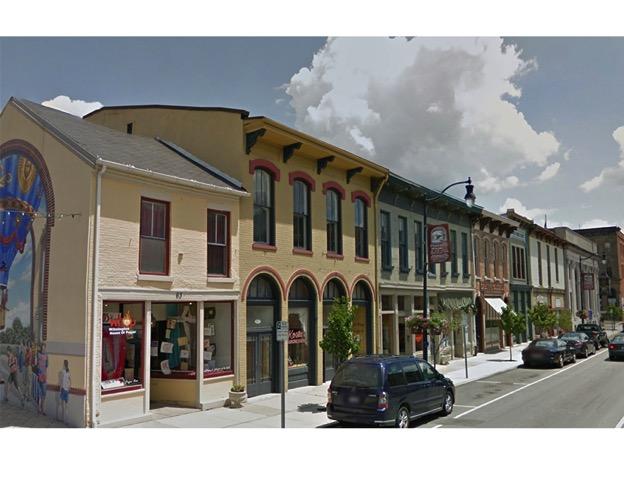
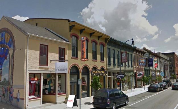
30 Figure14showsthesignsattwomainstreetsinDowntownWilmington(MainStreetandN SouthStreet),wheremostlyallretailstoresandservicestoreslocate.Wecanclearlysee mostlyallofthesignsarewindowssignsandthequalityofsignsneedtobeimproved. Figure14:SignageHeightAnalysis The last analysis is for the evaluation for all signs in Downtown Wilmington; I classify 9 differentkindsofsigns,andshowthenumberofsignsinfigure15.agoodsignagesystem needstohavealldifferentkindsofsigns,butindowntownwilmington,itlacksadiversity ofsigns.thestorefrontwindowsignsisthemainpartofsignsindowntownwilmington.in my thesis, I will try to create all kinds of signs which are suitable for Downtown Wilmington, and not only for retail store signs, but it will also include wayfinding signs, 22

31 welcome signs, temporary signs and so on. The goal is to make Downtown Wilmington morelegibleandreadable. Figure15:SignageCategoryAnalysis Signage is to ensure that correct information can convey an important prerequisite. Scientificandrationalsignagemustbeconsideredasaholisticandcompletesystem.The signage system should be able to have some reasonable artistic elements, which will not onlyensurethatsignscanachievetheirbasicfunctions,butalsoincreasevisualappealand enhancedthecommunicationbetweenpeopleandcity. 23
32 There are two main weaknesses for the signage system in Downtown Wilmington: 1) no connection,andlackinganoverallplan.2)thedesignistoosimple,lackingrepresentation ofthecity scharacter. The signage system should have a new understanding; it should not be confined only to trafficsings.asignagesystemforacitythatisaverylargeinvolvesmanyareasofthecity. Itnotonlyallowsurbantraffictoflowinanorderlyfashion,butalsoforthenamecardfor thecity.itshoulddemonstratesocial,culturalvalueandareavalues.agoodsignagesystem should combine factors to create a never get lost city, so the city will become more humane,anditwillnarrowthedistancebetweenthepeopleandthecity StreetViewEvaluation ThestreetviewevaluationmapisthewaytoknowDowntownWilmingtonindetails.Each picturewastakenevery10feetoneachstreet,whichshowslotsofdetailsinformationin DowntownWilmington.Forinstance,thenumberoftrashcans?Sidewalkcondition?Tree canopydensity?thestreetviewevaluationmapprovidesanswerstothesequestions. I selected four main streets in Downtown Wilmington, and have provided an evaluation summaryforeachpicture.figure20showsthezoomedinmapforthemainintersection. 24
33 25
34 26
35 27
36 28

37 Figure20:Street View Evaluation-Zoom In 2.3.4ComprehensiveSiteAnalysisMap The comprehensive site analysis map shows all the problems and current situation together,whichcombinesallofthefactorstogether. Themaphastwomainparts: 1: Current situation: landmark, parking lot, green space, industrial area, highest building andmainaccess. 2:Problems:nocrosswalk,openspacenotusedwell,nosenseofentrance,badconnection andnoconnection. Therearetwodetailedmapsshowingthefourmainblocks,thefirstoneisfortheproblems, andthelastoneisforthecurrentsituation.allthreemapsarethebasementforideaand design. 29
38 30
39 Figure22:ComprehensiveSiteAnalysisMapcDetail1 Figure23:ComprehensiveSiteAnalysisMapcDetail2 31
40 3Ideas Afterreviewingtheanalysismap,therearetwoideamapsconsideringdifferentscalesthat act as a transition, before design and planning, this gives an overview of the City of Wilmington sneeds. 3.1CityScaleIdeaMap The city scale idea map shows how to connect each area, such as green space, airpark, DowntownWilmingtonandthecommercialarea.Inmyideamap,Iwanttousebikelaneto connect these areas. Another point is the multicfamily housing around Downtown Wilmington. Figure24:Cityscaleideamap 32

41 3.2DowntownScaleIdeaMap The downtown scale idea map reflects the problems put forth in The Problems section. AllthedesignsandplanningarethesolutionsfortheproblemswhichWilmingtonfacing. Theideasinclude:wayfindingsigns,wallprinting,welcomesigns,openspaceredesignand so on. The main goal of the ideas is to make Downtown Wilmington more diverse and legible. Figure25:Downtownscaleideamap 33
42 4CaseStudy My thesis is about how to redesign or enhance the identity of the city, creating a comprehensive legible cityscape in Downtown Wilmington that is compatible with its historiccharacter,andtodifferentiateexistingandemergingdistricts.thegoalofmythesis is to make Downtown Wilmington more walkable and improve the flow of activities. Wayfindingisthemainpartofthecityredesignplan.Thus,Ilookedintosomearticlesand projects that talk about city redesign plan and wayfinding systems. These articles and projectsprovidedabasistouseinmyoverallcityredesignplan. 4.1DowntownAustinWayfindingMasterPlan TheWayfindingMasterPlanoutlinespriorityprojects,initiativesandapproachesthatwill helptoestablishaphasingplanforbothshorttermandlongtermopportunities.phasingis based on the complexity of the system and the funding available. (Signage Foundation, 2013) Thewayfindingsystemwillestablishaunifyinggraphiclanguageacrossawidevarietyof communication elements in Downtown Austin. Further awareness of the system can be achieved by creating a memorable identity for the overall Downtown Austin Wayfinding system.thiswillestablishthewayfindingsystemasahelpfultoolthatpresentsaustinas anorganized,thoughtfulandwelcomingcity. (SignageFoundation,2013) 34

43 ProjectObjectives PromoteDowntownAustinasafriendly,wellcplanned,organizedandsafeenvironment Thedesignshallbeofitsplace Buildconsensusthroughpublicinput Seamlesslyintegrateavarietyofwayfindingtools Gatewaysshallconsiderlandscaping,lightingandpublicart Promotethe ParkcOnce philosophy Enhancepedestriantravelandaccessibility Supportmulticmodaltransportationandsustainableinitiatives Createapublicoutreachplanthatpromotesthewayfindingsystem DevelopaStrategicImplementationPlanandarealisticphasingsequence Identifyfundingsourcesandcreativestrategies Developaplanforlongctermmanagementandmaintenance(CityofAustin,Taxes,2013) Maps Figure26:WayfingdingMapforDowntownAustin,FormCityofAustin,Taxes 35
44 Conclusion: TherearesomanydifferencesbetweenDowntownAustinandDowntownWilmington,not only the size and population, but also they are in different area. Austin is a city that is growing, while Wilmington is facing population stagnancy with rising unemployment. Therearestilllearningopportunitiesfromthiscase.Theprocess,thegoalsandobjectives, themapforsignageandwayfindingareperfectexamples. 4.2:UrbanWayfindingPlanningandImplementationManual CaseStudy:RockvilleTownCenter,MD TheRockvilleTownCenterisamongtheleadingexamplesofapublic/privatepartnership for the development of a new mixedcuse transitcoriented development. Centered on the Rockville Town Square mixed use project, the Town Center contains a number of innovativewayfindingsystemapproaches. (SignageFoundation,2013) PlanningInnovation Wayfinding elements including signs, gateways, street furniture, public places and directorieswerepartoftheplanningprocessfromthebeginningofthesitedevelopment process. This allowed these elements to be part of larger streetscape projects, which allowedforfasterdevelopmentduetoearlyfinancingandprecexistingstakeholdergroups. (SignageFoundation,2013) 36
 OngoingDevelopment TheTownCenterplanismeanttobedevelopedoverdecades.")
45 DesignInnovation Thelevelofintegrationofdesignelementswiththestreetscape,commercialbuildingsand parkingfacilitiesmadeforbothahighlycomplementarydesign(byselbertperkinsdesign), andamixofuniquefountainsandpublicspaces. (SignageFoundation,2013) OngoingDevelopment TheTownCenterplanismeanttobedevelopedoverdecades.Inrecentyears,alibrary, innovationcenterandapartmenthomeshavebeenadded.aseriesofguidelinesincluding wayfindingaspartofthelargerurbandesignhasmaintainedthecohesionoftheproject. (SignageFoundation,2013) Photos 1 Figure27:SignageDesigninRockvilleTownCenter,M,From:SignageFoundation 37
46 Conclusion ComparingRockvilleTownCenterandDowntownWilmington,wecanfindaverysimilar situation.botharesmallcitiesortownshipcenterswithjustafewblocksinthecbdarea, which means they probably do not have enough funding for the redesign plan or wayfindingsystem.inrockvilletowncenter,morethan70%oftheprojectwasdeveloped through private funding. Wilmington could follow suit, and they could develop a new wayfindingsystemwithprivatefunding. 38
47 5ResearchProcedures Researchmethodology ThemethodologythatIwilluseformythesisisdesignandevaluation.Iwilldothedesign firstbasedontheexistingconditionandanalysismap,andafterthatiwilldosomeanalysis workthatwillletusknowwhatthisprojectwillgivetothecity. InstrumentationandData 1:GIS:TheGISdatawillbecollectedfromwww.clintoncountyohgis.org' 2:TheanalysismapdatacamefromthefieldresearchintheCityofWilmington. 3:ThedatafrommeetingwithClintonCountyPlanningCommission. SpecificProcedures 1:Basedonanalysismap,identifystreetsneedingredesign 2:EstablishhowmanylocalresidentswillgotoDowntownWilmington 3:EstablishwhatkindofsignageisneededinDowntownWilmington 4:CreateacomprehensivelegiblecityscapeplanfortheCityofWilmington 39
48 6DesignandPlanning In this section, I will provide eight different solutions for problems that the City of Wilmington is facing. It includes: retail store sign design, creating a sense of entrance, wayfindingsigns,creatingorredesigningopenspace,mainintersectionredesign,bikelane anddetaildesign,factoryredesignandwallprinting. 6.1:RetailStoreSignsDesign Intoday surbanenvironment,especiallyinthecity scentralbusinessdistrict,ifthesignage system is not sufficiently systematic and standardized, it not only affects local people s dailylife,butalsoitwillgiveabadimpressionforvisitors.agoodsignagedesignforretail storesislikeanametagforacity. ForDowntownWilmington,Ipickedarepresentativestreettoredesign.Inthedesignpart, Imadesignsatdifferentheights,colorsandtextures.Texturesconsideredsurfacessuchas wood, stone, and metal. Meanwhile, the signage system will fully consider human visual comfort,suchasheightsetting,fontsizeandscaleofthemap. Figure28andfigure29comparethecurrentsituationandtheredesign: 40
49 Figure28:StreetViewwithoutSignageDesign Figure29:StreetViewwithSignageDesign 41
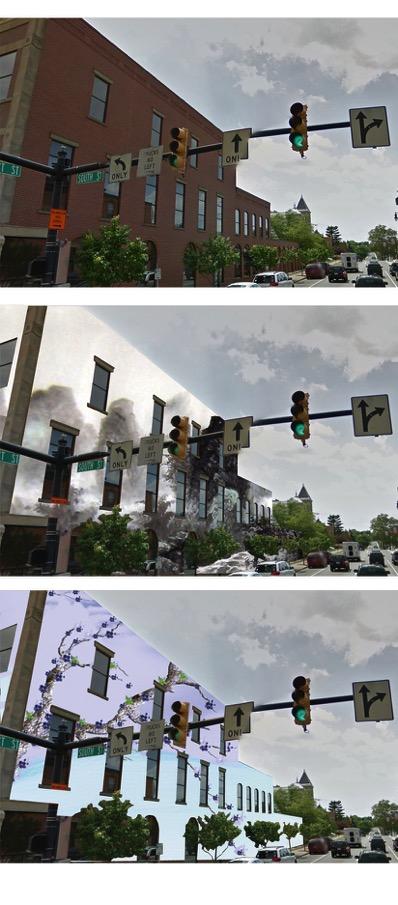
50 6.2CreateSenseofEntrance Anentrancetothecityisthefirstimpressionofthecity.Agoodentrancedesignisoneof themostimportantpartsforthelegiblecityscapeplan.itisthelinkofthecitytoconnect withtheoutside,andhasanimportantroleinthecommunicationbetweeninnerandouter city,intermsofmaterialenergyandinformationanditplaysanimportantroleinshaping the city s landscape. As a cultural and historical carrier, a good entrance design can increase the character and attraction of the city and bringing prosperity and vigor to the city. ForDowntownWilmington,Iusethemainentranceasthedesignexample(NSouthStreet). Theentranceischargedwiththemissiontoconveythecity scharacter,soinmydesign,i usethelogoofwilmingtoninwallprintingandawelcomesignwithwilmington sstyle.it maintains the continuity of the local historical context and transfers the local cultural information.ididtwodifferentdesignsusinglocalflavorandwilmington slogo. Thefigureshowsthecomparisonofthecurrentsituationandwhatislookslikeafterthe redesign: 42
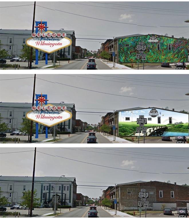
51 Figure30:ComparisonforEntranceDesign 43
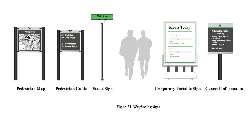
52 6.3WayfindingSigns Wayfindingsignsplacedthroughouteverycornerofthecityprovidesagreatconvenience forpeople sdailylife.itprovidesallkindsofinformationtohelppeoplebetterunderstand thecity.italsohelpstobuildaricher,deeperrelationshipbetweenthepeopleandcity.the wayfingdingsystemshouldtakethecityasawhole:anentireurbanenvironment,downto thebuilding,eachpartshouldhaveitsownwayfindingsystem,itshouldletlocalpeopleor visitorsfeelcomfortableindailylifeandintravelinginthecity. Baseonthedifferentfunctionsofthecity sareas,wecanconsiderfourdistinctparts: 1:Trafficwayfindingsystem:roads,districts,subways,busstationsandsoon. 2:Commercialwayfindingsystem:supermarkets,hotels,andrestaurants. 3:Publicinformationwayfindingsystem:government,hospital,andlibrary. 4:Attractionwayfindingsystem:openspace,recreationalareasandforest. In Downtown Wilmington, there are almost no wayfinding signs, and there is little attention given to it. In my design, I will implement a wayfinding system as an indispensablepartofthebuiltenvironmentandplanningofwilmington. Inthedesignpart,IcreateaseriesofwayfindingsignsfortheCityofWilmington. 44
53 45
54 6.4CreateorRedesignOpenSpace Openspacesareavitalpartofacity.Itisthepublicareafordailyactivities,anditisalsoan areathatshowsthelocalhistoryandculture.itisthemainpartofurbanplanningandofa legiblecityscapeplan. InDowntownWilmington,thereareonlytwoopenspacesintheDowntown:theyarethe lawn around the Court House and a narrow open space between two buildings. It is not enoughforpeople sdailyuse. In the design part,it will have more open space for local people and visitors. All open spaces in Downtown Wilmington are based on human scale and include many elements, suchas:opencairstructures,waterfeaturesandstreetfurniture.therearethreedifferent kindsofopenspaces: 1:Parkinglotredesign:Ingeneral,mostparkinglotsinDowntownWilmingtonarenotfully used,sothenumberofparkinglotwilldeclineinordertomakemoreareaforopenspace. The new parking lot will have more public utilities, such as street seats, fountains and increasedtreecanopy. 2: Open space redesign: The new open space will have more function and more detail design,suchassundaymarket,landmarkandsoon. 46
inDowntownWilmington for the redesign, which is the area with the most population flow.")
55 3:Vacantparcelredesign:Infigure31,itshowsanabandonedgasstationredesignedasa retail store building,insidetheparcelthereisaparkingspacethatcancontainsixcars. Thereisalsoasignthatshows parkinglotinside. Figure32:OpenSpaceMap 6.5MainIntersectionRedesign Ipickedthemainintersection(MainStreetandNSouthStreet)inDowntownWilmington for the redesign, which is the area with the most population flow. The intersection is the transferpoint,bothforpeopleandcars.inthedesignsection,iconsidertheentiresituation thatincludes: 47

56 1:Pedestrianfirst:Therearefourspeedbumpsintheintersectionandtwointhemiddleof thestreet.allofthemcanmakethetrafficflowinareducedspeedtomakepedestriansfeel safer. 2:Widersidewalksaroundintersections:Thebiggerintersectionscanmakethepedestrian walkingdistanceshorter,anditisalsobettermarkedforpassingdrivers. 3:Moretreecanopy:ThetreecanopyinDowntownWilmingtonislacking.Increasedtree canopyblockstrafficandpedestrians,makingpeoplefeelsaferwhentheyarewalking. 4:Streetseats:Thestreetseatallowspeopletostayonthestreets,anditcanbeconsidered as a microcsquare on the street. During the holidays, it can also be use as a temporary boothforsmallbusinesses. Figure33:MainIntersectionMap 48
57 6.6BikeLaneandDetailDesign Inthelasttwodecades,bicycleshavebecomemoreandmorepopularasuseexpandedinto more and more areas such as leisure, fitness, social interaction and cultural experience. Fromtheperspectiveofthecity,thebicycleisareflectionofaspiritualcivilizationandthe urban cityscapeacts as animportant window. Good and bad bicycle traffic environments reflect the city as peoplecoriented or not,and it becomes more and more important for people sdailylife. InCityofWilmington,thereisa TriccountyGreenbeltBicycletrail.However,thebicycle trailisdisconnected.peoplealwayshaveashorttrip,becausetheyfeelunsafewhenthey want to cross the street. On the other hand, a complete bike lane makes each area in Wilmingtonhaveabetterconnection. Inthedesignandplanningsection,basedonthecurrentsituation,Imakesomenewbike lanestoconnecttheexistingbikelanes,aswellasconnectotherareas,suchastheforestin thewest,wilmingtoncollege,thecommercialareasanddowntownwilmington. Inthepast,peoplewantingtotraveltotheseareashadtodosobycar.Whenthebikelane comes out, it will change people s life style and trip mode. For the detail design, it will include: bicycle logo light boxes, bicycle traffic signs, speed bumps for coming traffic and restareas.thesedesignswillmakepeoplefeelmuchsaferthaninpastwhentheytraveled bybicycle. 49
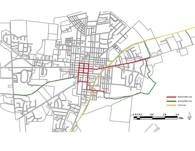

58 Figure34:BikeLaneMap Figure35:BikeLaneDetailDesign 50
59 6.7FactoryRedesign Today,alargenumberofoldindustrialbuildingsfacedwithnumerousproblems:someof themneedupdating;someofthemneedreconstructionorredesign.factoryredesignhas become one of the most important pieces in cityscape redesign, and we need to protect, developandreuseoldindustrialbuildings. The industrial area located in the east of Wilmington is very close to downtown. Some buildingsarealreadyabandoned,andsomeofthemareinverybadcondition.badstreet views have aterribleinfluence on cityscape. However, on the other hand, it is also an opportunity,becausethehighestbuildingforcityofwilmingtonislocatedintheindustrial area.ifwedomorearchitecturaldetaildesigntomakethebuildingsurfacemorecolorful ormoredetailed,itwillhaveahugedifferenceonstreetviews.theabandonedfactorywill alsobecomethemostfamousattractionforthecity. I used a Chinese case study as an example. In the design section, italsohaditshighest building;iaddedsomesurfacedesigntomakeitstandoutfromotherbuildingsmakingita landmarkforthatarea.thesamesituationappliesinwilmington,afterasurfaceredesign itwillbecomethelandmarkofthecity.otherbuildingscanbeusedasexhibitionbuildings, galleries, theme restaurants and so on. The new industrial area will become a new attractionforvisitors. Thefigure36showsthemodelasthesuggestionfortheWilmingtonindustrialarea redesign. 51

60 Figure36:FactoryRedesignExample 6.8WallPrinting InDowntownWilmington,somebuildingsareingoodcondition,butwithlessarchitectural details,sowallprintingisoneofthebestsolutionstogivebuildingsmoredesigndetails. WallprintingisalsoatraditioninWilmington;therearesomeverynicenewdrawingson buildingsinthelasttwoyears.wallprintingwillmakedowntownwilmingtonmorevivid andmoreartistic. Inmydesign,IhavetwodifferentstylesofdrawingfortheMunicipalCourtProbation.The firstoneislocalstyleprintingandanotherischineseprinting.bothofthemaresuitablefor thebuilding. 52
61 Figure37:ComparisonforWallPrinting 53

62 6.9SiteMap Thesitemapisacombinationoftheeightdesignandplanningsections.Alleightsections aresolutionsfortheproblems,whichthecityofwilmingtonisfacing.itshows: Figure38:SiteMap 54
63 Bibliography Bentley,I.(1987).Respinsive'Environments:'A'Manual'for'Desginers.Burlington: ArchitecturalPress. CityofAustin,Taxes.(2013).Downtown'Austin'Wayfinding'Master'Plan'.Retrievedfrom ftp://ftp.ci.austin.tx.us/npzd/austingo/final_wayfinding_masterplan.pdf Davies,L.(2000).Urban'Design'Compendium.London:ThehousingCorporation. DepartmentofNewYorkState.(2011).Municipal'Control'of'Signs.Retrievedfrom Fischer,E.(2000).'BuildingLivableCommunitiesforthe21stCentury.'PublicRoads. May/June,pp30c34. Metha,V.(2009).Tamoa'Urban'Design'Studio.Tampa:UniversityofSouthFlorida. Morrison,C.(2004).The'Rocks'Signage'Policy'Vilume'2:'Commercial'Signs.Retrievedfrom %20July04.pdf 55
64 Newsom,G.(2008).Better'Street'Plan.Retrievedfromhttp:// planning.org/ftp/betterstreets/proposals.htm NorthCentralRegionalCenterforRuralDevelopment.(1991).Visual'Merchandising'A' Guide'for'Small'Retailers.Retrievedfrom PortlandMainStreet.(2011).Portland'Main'Street'Design'Handbook.Retrievedfrom pdf.sflb.ashx SydneyHarbourForehoreAuthority.(2013).The'Rocks'Commercial'Signage.Retrieved fromhttp:// 8ABC3D8DA271B324.pdf SignageFoundation.(2013).Urban'Wayfinding'Planning'Implementation'Manual'. Retrievedfrom onmanualwebsite.pdf SoundTransit.(2004).SystemKwide'Signage'Design'Manual.Retrievedfrom 56
65 UniversityofNebraska.(2009).Wayfinding'and'Signage'Standards'Manual.Retrievedfrom UniversityofMinnesota.(2008).Belle'Plaine'Commercial'Boulevard'District'Guidelines. Retrievedfrom spp30c37.pdf 57
Community Design Plan
 Gardena General Plan 2006 Authority While the is not a required element of a General Plan, it is included because improving the community appearance and image is paramount to the overall quality of life
Downtown North Las Vegas Demonstration Site Project. Project Update
 Downtown North Las Vegas Demonstration Site Project Project Update 7.16.14 Presentation Overview Project Purpose and Process Planning Context Opportunities and Barriers Summary Community Input Preliminary
SECTION TWO: Overall Design Guidelines
 SECTION TWO: Overall Design Guidelines This section provides overall design principles and guidelines for the Gardnerville Mixed-use Overlay. They provide criteria for mixed-use places consisting of residential,
Table of Contents. Elm Avenue Improvement Plan City of Waco, Texas. Introduction 1. Existing Context 1 Figure 1 2.
 Table of Contents Introduction 1 Existing Context 1 Figure 1 2 Plan Guidelines 3 Future Urban Form 4 The West-End 4 Main Street 6 The East-End 7 Figure 2 9 Public Improvement Recommendations 7 General
PIKE PINE RENAISSANCE: ACT ONE. October 19, 2017
 PIKE PINE RENAISSANCE: ACT ONE October 19, 2017 WATERFRONT SEATTLE PROGRAM PROJECT INTRODUCTION Pike and Pine streets, between First and Melrose avenues Pedestrian and streetscape improvements Budget:
Urban Design 9Identity
 Urban Design 9Identity URBAN DESIGN IDENTITY Urban design is about connecting people to their places through the built environment, nature, and overall urban form. Done well, it creates a memorable space
UNION STUDIO Greater Kennedy Plaza!
 April May 2013 UNION STUDIO Greater Kennedy Plaza! It s time: Providence s civic plaza and transit hub is re-imagined as a vibrant urban gathering place 1 Kennedy Plaza Reborn THE TEAM Client: The City
greenprint midtown SUSTAINABILITY ACTION PLAN 2012
 greenprint midtown SUSTAINABILITY ACTION PLAN 2012 MIDTOWN ALLIANCE SOUTHFACE ENERGY INSTITUTE RENAISSANCE PLANNING GROUP SUSTAINABLE ATLANTA PERKINS+WILL 2 GREENPRINT MIDTOWN 1. Introduction Sustainability
City of Long Beach. creating vibrant and exciting places
 City of Long Beach creating vibrant and exciting places Land Use Element Urban Design Element Overview of the two draft General Plan elements Discuss areas of change Economic goals of the plans Case study
EXISTING COMPREHENSIVE PLAN
 EXISTING COMPREHENSIVE PLAN Town Center Land Use Element: V. LAND USE POLICIES Town Center Mercer Island's business district vision as described in "Your Mercer Island Citizen-Designed Downtown" was an
Port Lavaca Future Land Use
 Port Lavaca Future Land Use Introduction The City of Port Lavaca is beginning to see sustained growth, after many years of relative stable population. New single family homes, apartments, and businesses
Mark-up of the effect of the proposed Bronte Village Growth Area OPA No.18 on the text of section 24, Bronte Village, of the Livable Oakville Plan
 Mark-up of the effect of the proposed Bronte Village Growth Area OPA No.18 on the text of section 24, Bronte Village, of the Livable Oakville Plan Notes: This document is provided for information purposes
V. Vision and Guiding Principles
 V. Vision and Guiding Principles The Master Plan for the Powers Ferry Corridor seeks a foundation in the desires of the community. At times, various elements of the community offered opposing viewpoints,
Charles Eames Artist Studio AN APPLICATION OF PATTERN LANGUAGE TO THE ENTRANCE
 Charles Eames Artist Studio AN APPLICATION OF PATTERN LANGUAGE TO THE ENTRANCE MICHELLE HAY D263 DESIGN METHODS SPRING 2014 Contents 1 2 3 INTRODUCTION BACKGROUND CASE STUDY 3 4 12 INITIAL PLAN DESIGN
3.1 community vision. 3.3 required plan elements
 Chapter 3 Community Form 3.1 community vision 3.2 Parks & landscaping concepts 3.3 required plan elements D R A F T 20 Community Form Chapter 3 3.0 Community form 3.1 community vision The Specific Plan
WEST LOOP DESIGN GUIDELINES CHECKLIST
 WEST LOOP DESIGN GUIDELINES CHECKLIST Section 1.0 General Strategies 1.1 DESIGN EXCELLENCE: ENCOURAGE HIGH QUALITY AND INNOVATIVE DESIGN OF NEW BUILDINGS WITHIN THE WEST LOOP WITHOUT BEING PRESCRIPTIVE
8implementation. strategies
 PROGRAM STRATEGIES 8implementation strategies T he implementation actions of this chapter are designed to support and carry out the land use, economic development, transportation, urban design, and program
Hockessin Community Redevelopment Plan
 Hockessin Community Redevelopment Plan 3.1 Introduction The Community Redevelopment Plan for the Village of Hockessin is the result of the people s vision for a distinct village center that serves as the
Executive Summary. The Mebane CLP is not a regulatory document, but is intended to guide land development decisions. The plan includes:
 Executive Summary P URPOSE AND O RGANIZATION OF THE P LAN The City of Mebane, with input from citizens and an appointed CLP Advisory Committee, adopted Mebane by Design, a Comprehensive Land Development
Wayfinding. North Gateway: Integrate a vertical gateway marker on the west side of Ward Street at the south corner of Vernon Street.
 3.3.6.2 Wayfinding Existing Conditions Wayfinding signage is important to direct visitors and tourists to different locations in the downtown. A significant part of the wayfinding signage in the downtown
Include new ideas developed during this planning process
 Pull ideas from several previously adopted plans Noblesville Alternative Transportation Plan (2015) PLANoblesville (2016) Noblesville Downtown Parking Study (2016) Cultural Arts Blueprint (2016) Alley
Project Consulting Team:
 THE DOWNTOWN CHERRYVILLE LAND USE + STREETSCAPE MASTER PLAN WAS FUNDED THROUGH THE GENEROUS DONATIONS OF THE FOLLOWING: The Community Foundation of Gaston County ElectriCities of North Carolina The Cherryville
ITEM #8. Regional Smart Growth Program. Regional Smart Growth Program. Presentation Overview. Coast Highway Vision and Stategic Plan.
 Regional Smart Growth Program Economic Development Commission What is Smart Growth? Adopted as part of the Regional Comprehensive Plan (RCP) RCP provides vision for region based on Smart Growth and sustainability
Welcome & Introductions
 Charrette Week Report Back - Thursday Evening April 25, 2013 Welcome & Introductions A New Master Plan Land Use and Circulation Putting data and information to work to create solutions for the master plan
PUBLIC RIGHT-OF-WAY IN THIS CHAPTER PUBLIC REALM
 PUBLIC RIGHT-OF-WAY This section provides design guidelines for improvements in the public right-of-way. The public right-of-way refers to streets, sidewalks, non-vehicular thoroughfares, parks and greenways
Mississippi Drive Corridor Revitalization. A DestinationTransportation Project...
 Mississippi Drive Corridor Revitalization A DestinationTransportation Project... Mississippi Drive Corridor Revitalization Welcome! Tonight s Agenda: Further define the Scope of the Project Discuss the
W O R K S H O P S U M M A R Y. Community Workshop #1: Visioning September 11th, 2007
 W O R K S H O P S U M M A R Y Community Workshop #1: Visioning September 11th, 2007 Upper Market Community Workshop Series and Design Plan Page 1 of 9 INTRODUCTION The Upper Market Community Workshop Series
A Vibrant Downtown. Chapter 5 Cary Public Art Opportunities 31
 A Vibrant Downtown Cary s vision for Downtown is a unique, vibrant, dynamic, pedestrian friendly location; a regional destination and a place to live, work, and recreate, according to the 2001 Town Center
Proposed Reconstruction of Cleveland s Public Square
 Proposed Reconstruction of Cleveland s Public Square This information packet describes a proposed reconstruction of Cleveland s Public Square. The purpose of the reconstruction is to make Public Square
Potential Green Infrastructure Strategies May 6, 2015 Workshop
 Potential Green Infrastructure Strategies May 6, 2015 Workshop Background The City of Cortland is developing the Tioughnioga Urban Headwaters Green Infrastructure Action Plan with funding from the National
Sheridan Boulevard S TAT I O N A R E A P L A N S H E R I D A N B O U L E VA R D S TAT I O N A R E A P L A N
 Sheridan Boulevard S TAT I O N A R E A P L A N 1 City of Lakewood Adopted November, 2006 S H E R I D A N B O U L E VA R D S TAT I O N A R E A P L A N The Vision The City of Lakewood s overall vision is
DOWNTOWN NORFOLK COUNCIL ACTION PLAN. Strategic Initiatives Focus Area Objectives. Departmental Focus Area Key Objectives
 DOWNTOWN NORFOLK COUNCIL ACTION PLAN FY18 Strategic Initiatives Focus Area Objectives Departmental Focus Area Key Objectives STRATEGIC INITIATIVES FOCUS AREA OBJECTIVE #1: NURTURE A VIBRANT URBAN ENVIRONMENT
FLORIN ROAD CORRIDOR Site Plan and Design Review Guidelines Checklist
 FLORIN ROAD CORRIDOR Site Plan and Design Review Guidelines Checklist Applicant s Name: Project Address: Phone: Email: Applicant shall fill out the design guidelines checklist for all guidelines applicable
Preservation Planning
 Protect and Maintain the Historic Character of your Community Beverly, West Virginia Randolph County HLC PROTECT Purpose of all work done in survey and registration is not to only register properties.
NATICK COMPREHENSIVE MASTER PLAN. Natick Center Outreach Meeting. After presentations about the Natick Master Plan process, town staff and
 Meeting Notes After presentations about the Natick 2030+ Master Plan process, town staff and consultants from Crosby, Schlessinger and Smallridge posed questions to the audience. Responses are cataloged
Corridors. Re-vitalize our Corridors and Gateways
 Corridors Re-vitalize our Corridors and Gateways Artist s rendering from the 287 Strategic Plan, 2015 Corridors are the major throughways of Loveland but they also provide important commercial, community
CHAPTER 7: Transportation, Mobility and Circulation
 AGLE AREA COMMUNITY Plan CHAPTER 7 CHAPTER 7: Transportation, Mobility and Circulation Transportation, Mobility and Circulation The purpose of the Transportation, Mobility and Circulation Chapter is to
Public Meeting May 20, 2014
 Public Meeting May 20, 2014 Overview Study Purpose Study Area Overview Strategies Potential Opportunities Implementation and Discussion Skeo Solutions Raleigh Walkable Watershed Pilot 2 Purpose Develop
38 Queen s University Campus Master Plan Part 1
 38 Queen s University Campus Master Plan Part 1 46 The Campus at the City Scale Chapter 4 The Campus at the City Scale 39 Queen s is an urban University centrally located in Kingston. Decisions made by
Policies and Code Intent Sections Related to Town Center
 Policies and Code Intent Sections Related to Town Center The Town Center Vision is scattered throughout the Comprehensive Plan, development code and the 1994 Town Center Plan. What follows are sections
Maplewood Avenue Downtown Complete Street Project
 Maplewood Avenue Downtown Complete Street Project Second Public Meeting January 24, 2018 Welcome and Introduction of Project Team City Planning and Public Works Staff City of Portsmouth Juliet Walker Planning
CHAPTER 3 VISION, GOALS, & PLANNING PRINCIPLES. City of Greensburg Comprehensive Plan. Introduction. Vision Statement. Growth Management Goals.
 CHAPTER 3 VISION, GOALS, & PLANNING PRINCIPLES Introduction The Greensburg Comprehensive Plan is intended as a working community document. A combination of long and short-term goals, this document is intended
Public input has been an important part of the plan development process.
 Lakewood s Comprehensive Plan recognizes that transportation helps shape the community, and that the way the community provides for the safe and efficient movement of people affects the character of the
DRAFT City of Titusville 2040 Comprehensive Plan Future Land Use, Housing, and Transportation Elements April 16, 2018
 DRAFT City of Titusville 2040 Comprehensive Plan Future Land Use, Housing, and Transportation Elements April 16, 2018 Prepared by Canin Associates for the City of Titusville About the Comprehensive Plan:
V. Gateways GATEWAYS / V-1
 V. GATEWAYS / V-1 Many of Chesapeake s gateways are located on highways and call for bold and attractive designs that motorists can understand, appreciate, and enjoy. can also take the form of natural
appendix and street interface guidelines
 appendix five: building and street interface guidelines appendix 5 building and street interface guidelines BOULEVARDS Boulevards are generally characterized by higher levels of traffic movement at higher
4.1.3 LAND USE CATEGORIES
 4.1.3 LAND USE CATEGORIES a. City Center District The City Center District incorporates the existing character and mix of uses in downtown Belmont to encourage redevelopment and new development in keeping
July 12, Columbus City Council City Hall 90 West Broad Street Columbus, OH RE: I-70/71 Columbus Crossroads Project
 OHIO DEPARTMENT OF TRANSPORTATION DISTRICT 6 400 EAST WILLIAM STREET DELAWARE, OHIO 43015 800.372.7714 Columbus City Council City Hall 90 West Broad Street Columbus, OH 43215-9015 RE: I-70/71 Columbus
II. SINGLE FAMILY RESIDENTIAL
 II. SINGLE FAMILY RESIDENTIAL Castle Rock is made up of numerous individually built houses and subdivision tracts that have been developed during the past century. Some of the tracts are diverse in architectural
A Diamond in the Rough:
 A Diamond in the Rough: A Land Use and Design Concept Plan for the Princess and Division Streets Area, City of Kingston, Ontario Royce Fu Steve Jones A report submitted to the School ofurban and Regional
Development and Engineering Services
 To: From: Regular Meeting Date: June 11, 2018 Development and Engineering Services Subject: Development Permit Application No. DP 2018-002 Proposed free-standing restaurant with a drive-thru and patio
Taming Tysons Corner Transforming the Quintessential Edge City
 Taming Tysons Corner Transforming the Quintessential Edge City Transit is the greatest catalyst for change at Tysons, but how do we take advantage of this billion-dollar investment? If transit is built
Access Management: An Overview
 Figures 1-5 Below Evolution of development along a highway. In the early stages, land along the road is used for farming with little traffic generated. As time passes, the highway corridor becomes a de
A BLUEPRINT FOR BROCKTON A CITY-WIDE COMPREHENSIVE PLAN
 A BLUEPRINT FOR BROCKTON A CITY-WIDE COMPREHENSIVE PLAN Public Meeting October 2016 1 Plan Summary and Discussion Public Meeting May 4 2017 City of Brockton Bill Carpenter, Mayor Department of Planning
Downtown Lead Revitalization Project Final Recommendations. Three Proposed Options for the Revitalization of Downtown Lead
 Downtown Lead Revitalization Project Final Recommendations Three Proposed Options for the Revitalization of Downtown Lead November 1, 2011 Three Proposed Options for the Revitalization of Downtown Lead
Speakers: Yu-Jui, Lee. Key words: integrated development, evaluation of utilization
 A Post-Occupancy Evaluation Study of Traditional Shopping Street Reconstruction and Renovation A Case Study of Sanfong Central Street in Kaohsiung, Taiwan Speakers: Yu-Jui, Lee 1 Kao Yuan University, Kaohsiung
Information Session July 25, 2018
 Concord Pike (US 202) Master Plan Information Session July 25, 2018 1 Concord Pike (US 202) Master Plan 2018 Project Partners Wilmington Area Planning Council Delaware Department of Transportation New
Fifth and Detroit Street Design May 2017 Capital Improvements Committee. DOWNTOWN Street Design
 1 Fifth and Detroit Street Design May 2017 Capital Improvements Committee Agenda 2 Review Street Configuration Prior Meeting Review Outreach Synopsis Functional Street Design Refinements Curb Edge, Turning
Appendix A COMMUNITY IMPROVEMENT PLAN DESIGN GUIDELINES
 Appendix A COMMUNITY IMPROVEMENT PLAN DESIGN GUIDELINES INTRODUCTION The continuous and desirable improvement of Arnprior requires a clear understanding of what is envisioned for the Town. These Design
Chapter 1: Introduction
 Chapter 1: Introduction The Penn Avenue Community Works Corridor Vision and Implementation Framework presents an integrated communitybased vision and a coordinated, long-term implementation framework for
Elm Street Business District: Streetscape and Signage Plan
 Elm Street Business District: Streetscape and Signage Plan VILLAGE OF WINNETKA DOWNTOWN MASTER PLAN TASK FORCE MTG #1 Teska Associates 30 October 2017 AGENDA 1. Introductions and Walking Tour 2. Past Streetscape
4.9 Mendocino Avenue Corridor Plan Design Guidelines
 4.9 Mendocino Avenue Corridor Plan Design Guidelines The Mendocino Avenue Corridor Plan addresses the area between College Avenue and Steele Lane. Mendocino Avenue is a busy arterial that runs parallel
URBAN DESIGN BRIEF. 2136&2148 Trafalgar Road. Town of Oakville
 URBAN DESIGN BRIEF 2136&2148 Trafalgar Road Town of Oakville Prepared By: METROPOLITAN CONSULTING INC For 2500674 Ontario Inc November 2016 TABLE OF CONTENTS Page No. 1.0 Introduction/Description of Subject
Previous Stakeholder Meetings
 Titusville Tomorrow Previous Stakeholder Meetings Workshop 1 SWOT CVS Workshop 2 SWOT and CVS Results Value of Place Based Design 3 Table Top Designs The Waterfront The Gateways The Downtown Key Points
The Project. In 2013, construction was completed between 100 Street and 102 Street.
 The Project Jasper Avenue New Vision (JANV) is a major catalyst project identified in the Capital City Downtown Plan (2010) between 92 Street and 109 Street, including the streets half a block north and
Draft Bergamot Area Plan
 ATTACHMENT 1 Draft Bergamot Area Plan Taskforce on the Environment April 15, 2013 www.bergamotplan.net 1 Overview WHAT IS THE BERGAMOT AREA PLAN? A Community-Based Planning Document Guiding the Future
Project Goal. RRRC Living Towns Planning Workshp. Town of Halifax Revitalization Project. Dynamic Planning & Management Duo: July 12, 2006
 Project Goal Town of Halifax Revitalization Project RRRC Living Towns Planning Workshp July 12, 2006 Town of Halifax Halifax County *** Revitalization Project Goal*** To create Economic Opportunity and
The Lower SaLuda Greenway
 The Lower SaLuda Greenway InITIaTIve a FLourIShInG Greenway. a hub For economic GrowTh. a ConneCTIon BeTween CoMMunITIeS. In April 2017 the Michael J. Mungo Foundation and Lexington County commissioned
Transit-Oriented Development
 Transit-Oriented Development Path to Sustainability West Windsor February 22, 2007 George S. Hawkins Context for Presentation NJ Future is a non-partisan, 501(c)3 non-profit organization. Offer perspective,
Guiding Principles. People dance, and to share culture. Place consistency and internal connections. Management community for years to come
 3. The Campus Concept This chapter presents an overview of the Campus Concept from the formulations of its guiding principals through general recommendations to facilitate the triple urban design plan
urban design Introduction
 ACHIEVE SP RI NGF I ELD.3 Introduction Urban Design Areas Design Areas are areas within Springfield that have a unique and recognizable character that is different from other areas in the community. The
Cumberland Region Tomorrow is a private, non-profit, citizen based regional organization working with Greater Nashville Regional Council
 Cumberland Region Tomorrow is a private, non-profit, citizen based regional organization working with Greater Nashville Regional Council and others in the public and private sectors, dedicated to planning
THE CIVIC DISTRICT DEVELOPMENT OPPORTUNITIES
 1 THE CIVIC DISTRICT DEVELOPMENT OPPORTUNITIES The Civic District is the physical and emotional heart of the downtown. It is also a major gateway into the central core, establishing the image and identity
LUNDY S LANE COMMUNITY IMPROVEMENT PLAN STUDY
 PUBLIC INFORMATION MEETING #2 October 12, 2016 LUNDY S LANE COMMUNITY IMPROVEMENT PLAN STUDY AGENDA 5:00 to 5:30pm: Open House 5:30 to 6:15pm: Presentation 6:15 to 7:00pm: Individual paced workshop with
STREETSCAPE IMPROVEMENTS - RECOMMENDATIONS
 STREETSCAPE IMPROVEMENTS - RECOMMENDATIONS Figure 4.3.1- A map of all of the recommended streetscape improvements. The key component of downtown s public realm, apart from its public spaces, is its street
Lower Merion Commercial Districts Issues and Characteristics Handbook November 2013
 Lower Merion Commercial Districts Issues and Characteristics Handbook November 2013 DRAFT TOWNSHIP-WIDE VISION: To maintain and enhance commercial areas to complement the surrounding high-quality residential
Dyersville Downtown Plan. Open House October 24, 2017
 Dyersville Downtown Plan Open House October 24, 2017 What is a Comprehensive Plan? - Vision - Guidance for decisions - Basis for regulations What is a Downtown Plan? - Understand priorities - Identify
BUSINESS DISTRICT DESIGN GUIDELINES
 Des Plaines, Illinois Prepared for the City of Des Plaines by: The Lakota Group Laurie Marston, AICP March 2005 Section 5: Streetscape Elements Business District Design Guidelines STREETSCAPE ELEMENTS
Sign System Recommendations
 4.1 Sign System Recommendations 4.2 Recommended sign types required for a complete wayfinding system on the TCNJ campus are described below. Detailed sign messages and their typical locations are included
About Momentum Midland
 About Momentum Midland Achieving a community s full potential in terms of economic development and quality of life is critically important to its long term sustainability. Core to achieving this is a vibrant
TRANSIT NEIGHBORHOOD PLANS PROGRAM OVERVIEW
 TRANSIT NEIGHBORHOOD PLANS PROGRAM OVERVIEW OCTOBER 2017 Los Angeles Department of City Planning @LATNP and @Planning4LA Outline Introduction Policy Framework The Transit Neighborhood Plans Program Overview:
ROBBINSDALE LRT STATION CDI DEVELOPMENT GUIDELINES
 August 2018 OVERVIEW The City of Robbinsdale has a prime-opportunity site in the middle of the 13 mile stretch of the Bottineau LRT corridor / Blue Line extension. Robbinsdale offers a prominent, vital,
Copake Hamlet Plan: Visioning Workshop
 Copake Hamlet Plan: May 2-3 rd 2015 Design Team Mauricio Castro PLACE Alliance Ian Law PLACE Alliance Paula Diaz PLACE Alliance Mary Moore Wallinger PLACE Alliance Margaret Irwin River Street Planning
The Private Role in a Public-Private Partnership. Ask Me Anything Conference May 30, 2018
 The Private Role in a Public-Private Partnership Ask Me Anything Conference May 30, 2018 1 Thoughts to Share Today Schmit+Associates Essential Elements of a P3 Community Vision Market Demand Economic Viability
PROPOSED REDEVELOPMENT OF THE GLEN ABBEY GOLF CLUB. STREETSCAPE DESIGN STUDY (excerpt from the Urban Design Brief) TOWN OF OAKVILLE.
 TOWN OF OAKVILLE.") PROPOSED REDEVELOPMENT OF THE GLEN ABBEY GOLF CLUB STREETSCAPE DESIGN STUDY (excerpt from the Urban Design Brief) TOWN OF OAKVILLE OCTOBER, 2016 for 2.4.2 STREETS Streets are the single largest component
PROPOSED REDEVELOPMENT OF THE GLEN ABBEY GOLF CLUB STREETSCAPE DESIGN STUDY (excerpt from the Urban Design Brief) TOWN OF OAKVILLE OCTOBER, 2016 for 2.4.2 STREETS Streets are the single largest component
Pine Avenue Improvement Project
 Seaside Way to ocean Boulevard ocean Boulevard to 7 th Street 7 th Street to anaheim Street L O ng BeACh DeveLOpment ServiC e S Building a Better long Beach Pine Avenue Improvement Project Seaside Way
Robbinsdale LRT Station. CDI Development Guidelines. August Overview
 Robbinsdale LRT Station August 2018 Overview The City of Robbinsdale may have the coolest opportunity site along the 13 mile stretch of the Bottineau LRT corridor / Blue Line extension. Located a block
The University District envisions, in its neighborhood
 Envisioning the University District Link Light Rail in Seattle s neighborhoods CIY OF SEALE CONCEP-LEVEL SAION AREA PLANNING RECOMMENDAION RESOLUION # 30165 EXHIBI L Vision 08.2000 he University District
New Street Proposed Redevelopment Architecture & Urban Design Brief
 2130 2136 New Street Proposed Redevelopment Architecture & Urban Design Brief Prepared By: Cynthia Zahoruk Architect Inc. 3077 New Street, Burlington, ON, L7N 1M6 TABLE OF CONTENTS Background and Objective
Village Center Zoning. Town of Sutton, MA June 15, 2016
 Village Center Zoning Town of Sutton, MA June 15, 2016 Village Center Zoning Project Phase 1 was the development of the new Model Bylaw Phase 2 sought communities to work with to update existing or create
Image Credit: crja.com
 Image Credit: crja.com 6 ADDITIONAL PLACEMAKING ELEMENTS 6A 6B 6C 6D Signage and Wayfinding in the Public Realm Gateways Public Art Water Features ADDITIONAL PLACEMAKING ELEMENTS INTENT In addition to
City of Farmington. Downtown Plan. Amendment to the 1998 Master Plan Adopted October 11, 2004
 City of Farmington Amendment to the 1998 Master Plan Adopted October 11, 2004 Introduction Planning Background 1 Scope and Components of the Plan Amendment 2 Concept Introduction 3 Plan Concepts 3 Conceptual
RESEDA - WEST VAN NUYS COMMUNITY PLAN
 RESEDA - WEST VAN NUYS COMMUNITY PLAN Executive Summary As part of the initial outreach effort, the Department of City Planning hosted two workshops for the Reseda-West Van Nuys Community Plan Area during
Comprehensive Plan & Station Area Zoning
 Village of Tarrytown Comprehensive Plan & Station Area Zoning Public Workshop November 5, 2017 Warner Library WXY architecture + urban design Pace University - Land Use Law Center George M. Janes & Associates
TABLE OF CONTENTS CHAPTER TITLE PAGE DECLARATION DEDICATION ACKNOWLEDGEMENTS ABSTRACT ABSTRAK
 vii TABLE OF CONTENTS CHAPTER TITLE PAGE DECLARATION DEDICATION ACKNOWLEDGEMENTS ABSTRACT ABSTRAK TABLE OF CONTENTS LIST OF FIGURES LIST OF TABLES LIST OF ACROYMS LIST OF APPENDIXES ii iii iv v vi vii
VILLAGE OF SKOKIE Design Guidelines for Mixed-Use Districts NX Neighborhood Mixed-Use TX Transit Mixed-Use CX Core Mixed-Use
 VILLAGE OF SKOKIE Design Guidelines for Mixed-Use Districts NX Neighborhood Mixed-Use TX Transit Mixed-Use CX Core Mixed-Use TABLE OF CONTENTS CHAPTER 1 SITE DESIGN Purpose 1 CHAPTER 2 SITE DESIGN Streetscape
DOMINION BOULEVARD CORRIDOR STUDY AND ECONOMIC DEVELOPMENT STRATEGIC PLAN A MODEL FOR CHESAPEAKE S FUTURE
 DOMINION BOULEVARD CORRIDOR STUDY AND ECONOMIC DEVELOPMENT STRATEGIC PLAN A MODEL FOR CHESAPEAKE S FUTURE Overview I. Draft Plan Process II. Draft Plan Overview a. Market Analysis b. Master Land Use Plan
open house 3 CITY OF SALEM Downtown Streetscape Plan
 open house 3 Streetscape concepts CITY OF SALEM Downtown Streetscape Plan analysis concepts we are here refined concepts & document Feb 13th 1 2 3 apr 18th KICKOFF OPEN HOUSE Streetscape Work Group Walking
WEST BLACKHALL STREET PUBLIC REALM + TOWN CENTRE CONNECTIONS Public Exhibition 28 th June 2018
 WEST BLACKHALL STREET PUBLIC REALM + TOWN CENTRE CONNECTIONS Public Exhibition 28 th June 2018 Welcome Introduction Design Your Involvement Thank you for coming Engagement We would like to gather to this
CHAPTER 1. Ms. Guajardo s Class - Central Elementary CH 1 1
 INTRODUCTION CHAPTER 1 Ms. Guajardo s Class - Central Elementary CH 1 1 1.1 SETTING South Centre City is a linear corridor south of Downtown Escondido paralleling Centre City Parkway and South Escondido