Kempsville Planning Area
|
|
|
- Bryce Hudson
- 5 years ago
- Views:
Transcription

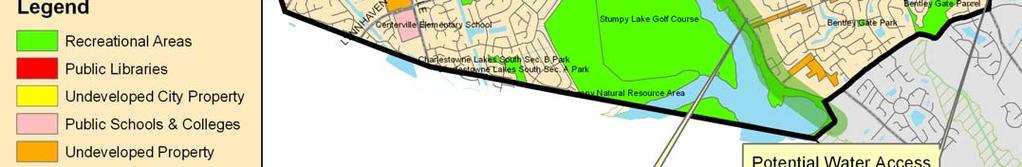
1 Kempsville Planning Area Current Reality The Kempsville Planning Area is by far the most populated planning area in the City. The preservation of the 1,422 Stumpy Lake Natural Area, the largest City-owned parkland, provides that much more of a positive impact because of the contrast with the development that surrounds it. It addition to Stumpy Lake Natural Area, over 45 park sites are currently located throughout Kempsville. City View Metro Park, Salem Woods Community Park and Woodstock Community Park are the most utilized larger parks. While Charlestown Athletic Park, Lark Downs and Newlight are the most utilized neighborhood parks because of the athletic facilities that exist at those sites. While the majority of Kempsville is developed, according to the City s Comprehensive Plan, it is projected that the planning area will see its population increase over the next 30 years by nearly 30%. The table below provides the 2000 census population as well as the theoretical build-out population for Kempsville, estimated in the City s 2003 Comprehensive Plan. The Kempsville Planning Area is geographically bound by Interstate 264 to the north; the Chesapeake/ Virginia Beach City line to the south and west; Salem Road and Princess Anne Road to the east. Year Percent Change Census Year ,301 Theoretical Build-Out Year ,123 28% While the proportion of growth projection figures cited above are generally correct, sole reliance on these figures should not be used for determinations of specific facility demand. Significant features that are uniquely located in the Kempsville Planning Area and affect the City s planning for outdoor recreation in the planning area include: City View Metro Park Stumpy Lake Natural Area Elizabeth River Landfill #2 The results of community involvement, statistical analysis, and equity mapping completed for the planning area explained on the forthcoming pages, applied to the unique circumstances of Kempsville, served as the primary drivers for the overall open space and outdoor planning recommendations that are provided at the end of this section. 77 Woodstock Community Park
2 Open Space/Parkland Statistical Analysis Open Space/Parkland Statistical Analysis - The table below applies the City s new park designation service standards to the planning area s 2000 census population as well as the projected theoretical build-out for the year The analysis includes park designations that can be located within relatively small geographic areas, such as planning areas. For example, three park designation standards are not applied to planning area analysis because they are larger in size and/or have a unique site characteristic that provides more of a citywide recreational opportunity. For example, Signature Parks, Natural Areas and Linkages (i.e. trails that transcend planning area boundaries) are not applied to the planning area analysis but are applied to the citywide statistical analysis provided in the Capital Improvement Program Impact section of this plan. Consequently, the planning area statistical standard for parkland/open space is 11 acres/1,000 residents while the city-wide statistical standard for parkland/open space is 16 acres/1,000 residents. Note: The statistical analysis is only one tool in determining service area gaps. Site Type and Virginia Beach Standard Neighborhood Parks /1,000 Community Parks /1,000 Metro Parks /1,000 Park Standard Applied to 2000 and Existing Park Inventory Existing Standard Existing Standard 43.5 Existing Standard Park Acreage Results for 2000 Need Need Need Park Standard Applied to 2026 and Existing Park Inventory Existing Standard Existing Standard 43.5 Existing Standard Park Acreage Results for 2026 Need Need Need General Open Space 1.0 Acre/1, Existing Standard Need Existing Standard Need Special Use Facility 1.0 Acre/1, Existing Standard Surplus Existing Standard Surplus School Parks 1.0 Acre/1, Existing Standard Surplus Existing Standard Need 26.9 Total Park 11.0 /1, Existing Standard Gross Need Existing Standard Gross Need Natural Resource Area* 1120 Existing Existing Total Analysis for Planning Area Homeowners ** Association Property Surplus Total Analysis for Planning Area Surplus Existing Existing *Site type applied only to city wide needs analysis, not individual planning areas ** Homeowners Association (HOA) Property are not counted toward meeting the public park and open space need because they are not accessible to all Virginia Beach residents. However, HOA should be considered as recreational assets for the residents of the planning area that have legal access to them. 78
3 Outdoor Recreational Asset Statistical Analysis Outdoor Recreational Amenity Statistical Analysis - Similar to the Open Space/Parkland Statistical Analysis, the table below applies the City s outdoor recreational site type service standards that are unique to Virginia Beach to the planning area s 2000 census population as well as the projected theoretical build-out for the year Note: The statistical analysis is only one tool in determining service area gaps. Asset Type and Virginia Beach Standard Tennis Courts 1 Court/5,000 Outdoor Basketballs 1 Court/2,500 Playgrounds 1 Site/2,000 Picnic Pavilions 1 Site/2,500 Baseball 200' Outfield 1 Field/3,125 Baseball 300' Outfield 1 Field/18,000 Softball (Youth Competitive) 1 Field/5,000 Softball (Adult Competitive) 1 Field/18,000 Soccer (Youth/Competitive/ Practice) 1 Field/4,000 Soccer (Regulation/Competitive/) 1 Field/6,000 Asset Standard Applied to 2000 and Existing Park Inventory 43 Courts Existing 20 Courts Standard 59 Courts Existing 41 Courts Standard 56 Existing 50 Standard 48 Existing 40 Standard 37 Existing 32 Standard 7 Existing 5 Standard 37 Existing 20 Standard 3 Existing 4 Standard 11 Existing 25 Standard 11 Existing 16 Standard Asset Results for 2000 Surplus 23 Courts Surplus 18 Courts Surplus 6 Surplus 8 Surplus 5 Surplus 2 Surplus 17 Need 1 Field Need 14 Need 5 Asset Standard Applied to 2026 and Existing Park Inventory 43 Courts Existing 26 Courts Standard 59 Courts Existing 52 Courts Standard 56 Existing 65 Standard 48 Existing 52 Standard 37 Existing 41 Standard 7 Existing 7 Standard 37 Existing 26 Standard 3 Existing 7 Standard 11 Existing 33 Standard 11 Existing 22 Standard Asset Results for 2026 Surplus 17 Courts Surplus 7 Courts Need 9 Need 4 Need 4 Need 0 Surplus 11 Need 4 Need 22 Need 11 Football (Competitive/Practice) 1 Field/6, Existing 16 Standard Need 5 11 Existing 22 Standard Need 11 Lacrosse/Field Hockey 1 Field/50,000 0 Existing 2 Standard Need 2 0 Existing 3 Standard Need 3 Dog Parks 1 Site/50,000 Skate Parks (Inline, Skateboard, BMX) 1 Site/50,000 1 Site Existing 2 Standard 1 Site Existing 2 Standard Need 1 Site Need 1 Site 1 Site Existing 3 Standard 1 Site Existing 3 Standard Need 2 Need 2 79

4 80

5 Ten-Minute Walk Zone Analysis The following map depicts walkable service areas based upon a ten-minute walk, based on a three mile-perhour walking pace, to parks in the Courthouse Planning Area. Areas highlighted in green are within a ten minute walk of a park utilizing the City s existing rights-of-way, showing areas that are currently served by City parks and areas that require additional focus of resources. The walk-zone analysis is much more practical of a service area analysis as opposed to the typical distance circle-radius service area buffers because they account for physical barriers such as Virginia Beach s many waterways and areas without roadways which cannot be crossed or otherwise accessed. Level Green Neighborhood Park Trail Connections An extensive asphalt shared-use pathway at the Level Green Neighborhood Park provides several connections to adjacent residential areas in addition to serving as a recreational amenity for the park itself. 81


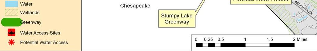
6 Bikeways and Trails System - According to the City s adopted Bikeways and Trails Plan, the following bikeways and trails system initiatives either existing or are recommended for implementation: Witchduck Road New shared use paths are being planned with the roadway widening project on both sides of the new roadway between Witchduck Road and I-264 Princess Anne/Kempsville Road Intersection Improvement Project Historic Kempsville Plan pedestrian connectivity improvements Indian River Road Phase VII Improvement Potential for Stumpy Lake to Back Bay Greenway 82


7 Kempsville Recommendations Stumpy Lake Natural Area Master Plan Implement phased public access improvements as recommended in the Master Plan with connections to Woodbridge area on Lynnhaven Parkway. Stumpy Lake to Back Bay Greenway- Develop a comprehensive corridor feasibility and green infrastructure study for the Stumpy Lake to Back Bay Greenway. Avalon Woods Site / Neighborhood Park Gaps Address neighborhood park service area gaps in Arrowhead, College Park/Level Green, and Woods of Avalon. The proposed Avalon Woods Neighborhood Park site is shown to the left. Historic Kempsville Plan Coordinate with Princess Anne/Kempsville Road Intersection project to incorporate central plaza/open space and pedestrian connections to existing neighborhoods as well as planned mixed use areas. Woodbridge Community Park - Develop and implement a master plan for the 25-acre wooded parcel that can potentially serve both as an additional link to the Stumpy Lake Natural Area from Lynnhaven Parkway as well as a park for the Woodbridge area residents. Parks and Recreation Planning Resource for Homeowner Associations Serve as a resource to homeowners associations, such as Indian Lakes, by providing advice in the planning of capital improvement development and maintenance of recreation-related land and facilities. School Field Improvements Coordinate with Schools to improve existing athletic fields to increase their potential for additional athletic program. City View Park Expansion/Landfill #2 End Use Monitor the use of Landfill #2, which comprises over 400 acres, to determine appropriate time for developing an master plan for the expansion of City View Park. 83

8 Kempsville Recommendations Skate Park Need - The 2026 statistical analysis shows a need for two additional skate parks to serve the Kempsville Planning Area, in addition to Woodstock Skate Plaza which opened in April It is recommended that the City continue with its overall City-wide action sports park strategy to consider providing additional community parkscale skate parks after evaluating annual trends with attendance at existing municipal skate parks. If there is a demonstrated need for another skate park in this area, it is recommended that either Woodstock Skate Plaza be expanded or that a new skate park be considered for City View Metro Park. Elizabeth River Greenway Develop a comprehensive corridor feasibility and green infrastructure study for the Elizabeth River Greenway. Public Access to Elizabeth River and Tributaries Evaluate providing non-motorized watercraft public access improvements to the Elizabeth River at the Avalon Woods site and Hunts Pointe Park. Public Access to Salem Canal Evaluate providing non-motorized watercraft public access improvements to the Salem Canal at either Salem Woods or Wyndamere Parks. Virginia Power Right-of-Way - Acquire a strategic 4.4mile long, 66-foot wide linkage that extends from the Municipal Center through the Holland and Kempsville Planning Areas to Baxter Road. The corridor has the potential to serve as a potential linear park and shared-use pathway, similar to the existing trail network parallel to Rosemont Road and Independence Boulevard. 84
Courthouse Planning Area
 Courthouse Planning Area Current Reality The Courthouse Planning Area is the characterized by expansive suburbanscale residential areas as well as the community resource planned area of athletic, educational,
Little Neck Planning Area
 Little Neck Planning Area Current Reality The Little Neck Planning Area is characterized by established residential neighborhoods, Town Center and Pembroke. The Eastern and Western Branches of the Lynnhaven
Great Neck Planning Area
 Great Neck Planning Area Current Reality The Great Neck Planning area is characterized primarily by large lot/lowdensity residential development with the majority of recreational opportunity existing as
Pungo/Blackwater Planning Area
 Pungo/Blackwater Planning Area Current Reality The Pungo/Blackwater Planning Area represents the rural landscape and lifestyle that encompasses nearly 40% of Virginia Beach. The Agricultural Reserve Program
RECREATION AND OPEN SPACE ELEMENT
 RECREATION AND OPEN SPACE ELEMENT Last amended August 19, 2008 Table of Contents Objective Page 5.1 Park system defined... 5-1 5.2 Access to parks and recreational facilities... 5-2 5.3 Recreation and
Appendix A. Park Land Definitions
 Appendix A Park Land Definitions Mini Park May serve specific function for any and all ages, depending on need of the user area. Size range 1-5 acres with optimum size being 3 acres. Service area is sub-neighborhood
APPENDIX D2: PARKS AND TRAILS
 APPENDIX D2: PARKS AND TRAILS Cultivate Hopkins Comprehensive Plan 8/15/18 DRAFT Cultivate Hopkins Appendix D2 1 Existing Conditions Local Parks and Trails Figure D2.1 shows the existing park and trail
Outdoor Recreation Facilities Inventory
 Outdoor Recreation Facilities Inventory Allouez Neighborhood Parks: East Lawn Park (4.90 acres) is located in the northeastern corner of Allouez near Boyd Street. This site contains: Baseball diamond with
Centerville SGA. virginia beach, va. Prepared for the City of Virginia Beach February,
 Centerville SGA virginia beach, va Phase 3 presentation Prepared for the City of 12-13 February, 2013 www.vbgov.com/centervilleplan urban design associates miles agency, rclco, urs, vhb & wpl A Three Phase
Southeast Quadrant Plan
 Southeast Quadrant Plan Southeast Quadrant Distinctive Features Land Use The Southeast Quadrant includes all the area within the planning area that is east of Interstate 5 and south of State Route 44.
Provide and maintain sufficient public parks, recreation facilities, and open space to meet the recreational needs of County residents and visitors.
 (ROS) Goal Provide and maintain sufficient public parks, recreation facilities, and open space to meet the recreational needs of County residents and visitors. OBJECTIVE ROS.01 The County shall acquire,
City Council March 27, Parks, Recreation, and Trails Master Plan
 City Council March 27, 2018 Parks, Recreation, and Trails Master Plan Planning Process Develop Goals and Objectives Inventory of Areas and Facilities Needs Assessment And Identification Public Participation
PARKS & RECREATION SUBCOMMITTEE. Oct. 1, 2015
 PARKS & RECREATION SUBCOMMITTEE Oct. 1, 2015 1999 Bond - $22,000,000 Land Acquisition Allen Station Phase II Neighborhood Parks PREVIOUS BOND ELECTIONS 1999 & 2007 2002 Bond - $4,000,000 Allen Senior Recreation
RECREATION AND OPEN SPACE ELEMENT GOALS, OBJECTIVES, AND POLICIES
 RECREATION AND OPEN SPACE ELEMENT GOALS, OBJECTIVES, AND POLICIES Goal 7 To provide park facilities, recreation programs, and open space resources that are safe, adequate, and accessible to all City residents,
Westwood Shopping Center Sketch Plan, Plan # February 23, 2017 Item # 9
 Westwood Shopping Center Sketch Plan, Plan # 320170010 February 23, 2017 Item # 9 Westwood II Site 64,111 s.f. Manor Care site: vacant two story building HOC-Westwood Towers, 15 story tower To be considered
PARKS AND RECREATION
 PARKS AND RECREATION WHAT YOU WILL FIND IN THIS CHAPTER: Background information on the development of the Park, Recreation, and System Plan (PRSP). General overview of Ellensburg s parks and recreation
SCHOOLS, PARKS AND TRAILS
 Schools, Parks, and Trails Page 1 of 12 SCHOOLS, PARKS AND TRAILS BACKGROUND Public Schools in the Clifton-Fruitvale Community include Clifton Elementary, Rocky Mountain Elementary, Grand Mesa Middle,
RECREATION, OPEN SPACE AND GREENWAYS ELEMENT GOALS, OBJECTIVES, AND POLICIES
 RECREATION, OPEN SPACE AND GREENWAYS ELEMENT GOALS, OBJECTIVES, AND POLICIES GOAL R-1: DEVELOP A RECREATION, OPEN SPACE AND GREENWAYS SYSTEM AS AN INTEGRAL COMPONENT OF AN OVERALL, COUNTY-WIDE ECONOMIC
10.0 Open Space and Public Realm
 10.0 Open Space and Public Realm 10.0 Open Space and Public Realm The Public Open Space System is comprised of: outdoor spaces available for public use that are either publicly owned (e.g., parks and
Overview of the Plan. The Building Blocks of Centers, Neighborhoods and Network INTERNAL DRAFT
 Overview of the Plan 4 East Davidson Ramah Church Rd June Washam Rd Bradford District Park Bradford Shearer Rd Campus District NC 73 Davidson-Concord North Rocky River This Master Plan projects an approximate
SOUTHEAST SPORTS COMPLEX MASTER PLAN
 REPORT TO SOUTHGATE NEIGHBORHOOD COUNCIL APRIL 13, 2016 Visioning Process April 30: Stakeholder Meeting with Sports Groups May 5: Stakeholder Meeting with Southgate Land Use Committee May 13: SNC Meeting
Section 3 INVENTORY OF RECREATION LAND AND FACILITIES
 Photo of Juan Bautista de Anza Park Section 3 INVENTORY OF RECREATION LAND AND FACILITIES Summary of Findings Park Definitions Summary of Recreation Facilities Other Recreation Facilities Nearby Recreation
DOMINION BOULEVARD CORRIDOR STUDY AND ECONOMIC DEVELOPMENT STRATEGIC PLAN A MODEL FOR CHESAPEAKE S FUTURE
 DOMINION BOULEVARD CORRIDOR STUDY AND ECONOMIC DEVELOPMENT STRATEGIC PLAN A MODEL FOR CHESAPEAKE S FUTURE Overview I. Draft Plan Process II. Draft Plan Overview a. Market Analysis b. Master Land Use Plan
PARTF Scoring System for Grants
 PARTF Scoring System for Grants The members of the N.C. Parks and Recreation Authority use the PARTF scoring system as one of several tools to select grant recipients. Please provide all of the information
Northeast Quadrant Plan
 Northeast Quadrant Plan Northeast Quadrant Distinctive Features Land Use The Northeast Quadrant includes all the area within the planning area that is east of Interstate 5 and to the north of State Route
1. Parks & Recreation Neighborhood Parks Community Parks Special Use Sites 2. Open Space 3. Trails
 Appendix A: Park Classifications The intent of parks and recreation classifications is to aid in making acquisition and design decisions for park sites, facilities and the organization of recreation space
STAFF RECOMMENDATION: Adopt the Parks and Recreation Master Plan 2013, or take other action as deemed appropriate.
 Regular 7. CITY COUNCIL AGENDA Meeting Date: 12/02/2013 TITLE: Parks and Recreation Master Plan 2013 Adoption Proposal - Dwight Curtis Responsible Staff: Dwight Curtis Backup Material: Backup material
THE PRINCESS ANNE COMMONS & TRANSITION AREA. It s Our Future
 THE PRINCESS ANNE COMMONS & TRANSITION AREA www.ourfuturevb.com It s Our Future THE PRINCESS ANNE COMMONS/ TRANSITION AREA Quality Development Planned Mix of Public and Private Uses Exceptional Open Spaces
Chapter 6. Overall Vision RECOMMENDATIONS. More Trail and Trail. Connections. Equal Access to Park. Facilities and Programs. Water Access.
 Overall Vision More Trail and Trail Connections Equal Access to Park Facilities and Programs Water Access Environment Variety Chapter 6 RECOMMENDATIONS Chapter 6 The following recommendations for park,
2015 annual report. virginia beach. open space program. virginia beach parks & recreation planning, design & development
 2015 annual report virginia beach open space program virginia beach parks & recreation planning, design & development Open space advisory Committee mission is to research and evaluate undeveloped properties
Comprehensive Parks and Recreation Master Plan. Executive Summary. Submitted To: City of Milton, GA October 2012
 Comprehensive Parks and Recreation Master Plan Executive Summary Submitted To: City of Milton, GA October 2012 Executive Summary The City of Milton envisioned the need for an effective Master Planning
Park Facilities Evaluation
 January 2013 Appendix D: Park Facilities Evaluation For more information, call the Park Planning and Stewardship Division at (301) 650-4380 Parks, Open Spaces, Trails & Recreation Facilities Appendix for
City of Naples Parks Master Plan (Draft)
") City of Naples (Draft) CSAB April 12, 2016 OVERVIEW Presentation Outline Overview Needs Assessment Recap Response to Needs Implementation Strategy Questions, Discussion Preserving Naples: A vision plan
City of Naples (Draft) CSAB April 12, 2016 OVERVIEW Presentation Outline Overview Needs Assessment Recap Response to Needs Implementation Strategy Questions, Discussion Preserving Naples: A vision plan
a) Inventory of all existing privately-owned, state-owned, or local governmentowned recreational facilities and open spaces within the context area
 Inventory of all existing privately-owned, state-owned, or local governmentowned recreational facilities and open spaces within the context area") 8.0 RECREATION AND OPEN SPACE ELEMENT (1) DATA REQUIREMENTS a) Inventory of all existing privately-owned, state-owned, or local governmentowned recreational facilities and open spaces within the context
8.0 RECREATION AND OPEN SPACE ELEMENT (1) DATA REQUIREMENTS a) Inventory of all existing privately-owned, state-owned, or local governmentowned recreational facilities and open spaces within the context
Parks Plan Overview. City of Toronto Parks, Forestry and Recreation Division
 Parks Plan Overview City of Toronto Parks, Forestry and Recreation Division 1 In February 2010 Council approved the development of a five year plan to guide the acquisition, development, management and
9. PARKS AND RECREATION
 9. PARKS AND RECREATION Goal: Create a comprehensive, maintained, and interconnected system of parks, pathways, and open spaces as well as a balanced program of recreational activities for residents of
Recreation/Open Space Element
 Recreation and Open Space Element [This page intentionally left blank.] Recreation and Open Space Element Table of Contents I. Purpose... ROS-1 II. Background... ROS-1 Context... ROS-1 Service Area...
6. RECREATION AND OPEN SPACE ELEMENT
 6. RECREATION AND OPEN SPACE Introduction This Recreation and Open Space Element includes Goals, Objectives and Policies (GOP) that apply to the main campus in Gainesville and the Lake Wauburg Recreation
Parks, and Recreation & Cultural Arts Master Plan Update
 Parks, and Recreation & Cultural Arts Master Plan Update Community Profile Public Input Summary: Staff Interviews conducted April 14 and 15, 2014 Citizens Workshop - conducted April 15 th and 24 th, May
Draft Stillwater 2030 Comprehensive Plan- Goals and Policies
 Draft Stillwater 2030 Comprehensive Plan- Goals and Policies Instructions- Review each goal and policy and discuss with group any changes, deletions for additions to the list using your groups pen. Keep
Appendix 4 Park, Trail, and Recreation Facilities For more information, call the Park Planning and Stewardship Division at
 Appendix 4 Park, Trail, and Recreation Facilities For more information, call the Park Planning and Stewardship Division at 301-650-4380 montgomery county planning board maryland-national capital park and
Pinellas County Greenways
 Pinellas County Greenways USING GREENWAYS TO LINK OPEN SPACES The Florida Greenways Commission has defined a greenway as...a corridor of protected open space that is managed for conservation and/or recreation.
I-494 Rehabilitation Project SP (I-394 to Fish Lake Interchange) June 2014 Section 4(f) De Minimis Determination
 June 2014 Section 4(f) De Minimis Determination") I-494 Rehabilitation Project SP 2785-330 (I-394 to Fish Lake Interchange) June 2014 Section 4(f) De Minimis Determination State Project Number 2785-330 Federal Project No. NHPP-I494 (002) Trunk Highway:
I-494 Rehabilitation Project SP 2785-330 (I-394 to Fish Lake Interchange) June 2014 Section 4(f) De Minimis Determination State Project Number 2785-330 Federal Project No. NHPP-I494 (002) Trunk Highway:
8.0 Recreation and Open Space Element
 8.0 PURPOSE The purpose of this element is to ensure the provision of adequate and accessible recreation facilities and open space to meet the future needs of the University. (1) DATA REQUIREMENTS. This
City of Fredericksburg, Texas
 City of Fredericksburg Acknowledgements City of Fredericksburg, PARKS, Texas RECREATION & OPEN SPACE Master Plan Prepared by: Dunkin Sims Stoffels, Inc. Landscape Architects / Planners Acknowledgements
Appendix E Section 4(f) Evaluation
 Evaluation") Appendix E Section 4(f) Evaluation Appendix E Draft Section 4(f) Evaluation E.1 Introduction This appendix addresses a federal regulation known as Section 4(f), which protects parks, recreation areas,
Appendix E Section 4(f) Evaluation Appendix E Draft Section 4(f) Evaluation E.1 Introduction This appendix addresses a federal regulation known as Section 4(f), which protects parks, recreation areas,
A citizen s guide to the. Comprehensive Plan. City of Lakeville, Minnesota 1
 A citizen s guide to the Comprehensive Plan 2008 City of Lakeville, Minnesota 1 Introduction The City of Lakeville completed an update of its Comprehensive Plan in 2008. A comprehensive plan is a tool
KASPER. City of Georgetown, Texas PUD Planned Unit Development. December 30, 2015 Revised January 27, 2016
 KASPER City of Georgetown, Texas PUD Planned Unit Development December 30, 2015 Revised January 27, 2016 Applicant: Sentinel Land Company, LLC 4910 Campus Drive Newport Beach, CA Prepared by: SEC Planning
Gloucester County s Comprehensive Plan. The Community Connection
 Gloucester County s Comprehensive Plan The Community Connection Current Comp Plan Adopted in 1991 with a 20 year planning horizon Updated in 1995 with Part V- Implementation Recommendations and Appendix
Section Three Recreation Standards & Needs Assessment
 Section Three Recreation Standards & Needs Assessment William M. Hargraves Center Introduction This section contains the analysis and assessment on which the recommendations of this Comprehensive Parks
The only significant recreation deficiency in Conway is the absence of an integrated greenway and multipurpose trail system.
 CHAPTER 6 RECREATION 1. Introduction This recreation chapter is prepared in compliance with recently revised state statutes dealing with the completion of municipal master plans [RSA 674:2 III (F)]. This
Elm Fork Land Use. Trinity River Corridor Project Committee May 13, 2013
 Elm Fork Land Use Trinity River Corridor Project Committee May 13, 2013 Purpose Discuss Trinity River planned Land Use and Appropriate Compatible Uses, particularly with respect to the Elm Fork Area 2
Attachment M 9. PARKS AND RECREATION 9.1 PARKS, TRAILS AND OPEN SPACE PLAN
 Attachment M 9. PARKS AND RECREATION Goal: Create a comprehensive, maintained, and interconnected system of parks, pathways, and open spaces as well as a balanced program of recreational activities for
The City shall enhance and improve the accessibility of parks and recreational facilities while protecting their quality. by:
 GOALS, OBJECTIVES AND POLICIES GOAL 1: To provide open space and recreation as an essential element needed for the betterment of the City s character and quality of urban life. The City shall plan for
TAO S PARKS MASTER PLAN
 TAO S PARKS MASTER PLAN December 2017 Kit Carson Park Fred aca Park Eco Park Youth + Family Center Eco Park TAOS PARKS MASTER PLAN December 2017 SCOPE OF WORK Town of Taos Parks + Recreation Master Plan
City of La Center Park, Recreation and Open Space Master Plan. March 2016 Draft
 City of La Center Park, Recreation and Open Space Master Plan March 2016 Draft Table of Contents. Chapter 1: Introduction... 1 1.1 Community Profile... 3 1.2 Master Plan Overview... 3 1.3 Planning Process...
M-NCPPC Park System in
 Park Planning & Stewardship Division Park & Trail Planning Section East County Science Center Master Plan Parks, Recreation, Trails, and Open Space- Issues and Opportunities PARK PLANNING & STEWARDSHIP
Element 0X Parks, Recreation and Open Space
 Element 0X Parks, Recreation and Open Space Table of Contents 1. Introduction 2. Major Issues, Concerns, and Citizen Input 3. Parks, Recreation and Open Space Goals & Policies 4. Analysis Background and
Sherwood Forest Park REVITALIZATION PLAN. Public Meeting (P.I.C) # 3 JUNE / 25 /2015
 # 3 JUNE / 25 /2015") Sherwood Forest Park REVITALIZATION PLAN Public Meeting (P.I.C) # 3 JUNE / 25 /2015 1 Agenda i. Where we are in the process and schedule ii. Consultation process iii. Key messages from PIC#2 iv. Purpose
Sherwood Forest Park REVITALIZATION PLAN Public Meeting (P.I.C) # 3 JUNE / 25 /2015 1 Agenda i. Where we are in the process and schedule ii. Consultation process iii. Key messages from PIC#2 iv. Purpose
The urban parks in Charlottesville include Jackson Park, Lee Park, and McGuffey Park.
 Park Classifications Charlottesville s parks can be grouped into 4 different classifications: urban parks, neighborhood parks, community parks, and regional parks. Figure 1 on page 5 inventories the facilities
The ParksPlan is not focused on Recreation programs and services, nor is it a recreation
 1 The ParksPlan is not focused on Recreation programs and services, nor is it a recreation facilities master plan. The Recreation Service Plan, which is currently in progress, focuses on recreation programs
process of the Land Development Code to assure regional parks are available County-wide.
 GOAL 9.0. It is the goal of the Broward County Board of County Commissioners to provide safe and adequate recreation sites and facilities, including cultural art facilities, and open space to satisfy the
Comprehensive Park System Master Plan
 PARKS AND RECREATION Comprehensive Park System Master Plan Citizen Advisory Committee, June 5, 2012 - Meeting Notes Transcription MIG met with the Parks Citizen Advisory Committee on Tuesday, June 5th,
Inventory of Existing Bikeways and Trails. Appendix A. Inventory of Existing Bikeways and Trails Appendix A
 Inventory of Existing Bikeways and Trails Virginia Beach Bikeways and Trails Plan 2011 Page A-1 This chart lists the bikeways and trails that are NOT in City parks. The chart is based on the GIS map of
APPENDIX D: BACKGROUND AND VISION
 APPENDIX D: BACKGROUND AND VISION BACKGROUND A. Specific Plan Location Jordan Downs is located at 9800 Grape Street in Los Angeles, California, 90002. The Jordan Downs Urban Village Specific Plan area
PARK, RECREATION AND TRAIL PLAN
 4.1 EXECUTIVE SUMMARY The Comprehensive Park, Recreation, and Trail Master Plan establishes the vision for the park system including maintenance, renovation and enhancement. The plan concludes that the
G. RECREATION AND OPEN SPACE ELEMENT. The following summarizes the Recreation and Open Space Element:
 G. RECREATION AND OPEN SPACE ELEMENT The purpose of the Element is to provide the framework and direction for a comprehensive system of public and private sites for recreation, including, but not limited
Revisions to 2009 Comprehensive Plan Policy Document Chapter 4: Princess Anne & Transition Area November 2014
 Revisions to 2009 Comprehensive Plan Policy Document Chapter 4: Princess Anne & Transition Area November 2014 (Pages 4-1 et subseq. of the Policy Document: Text to be deleted is shown as strikethrough.
Arlington, Virginia is a worldclass
 EXECUTIVE S U M M A RY Arlington maintains a rich variety of stable neighborhoods, quality schools and enlightened land use policies, and received the Environmental Protection Agency s highest award for
EL DORADO COUNTY GENERAL PLAN PARKS AND RECREATION ELEMENT PRINCIPLE INTRODUCTION STATE AUTHORIZATION
 EL DORADO COUNTY GENERAL PLAN PARKS AND RECREATION ELEMENT PRINCIPLE The General Plan must identify the types of governmental services, including parks and recreation facilities, which are necessary to
1.4 - PRINCESS ANNE COMMONS & TRANSITION AREA
 1.4 - PRINCESS ANNE COMMONS & TRANSITION AREA INTRODUCTION Princess Anne Commons and the Transition Area are strategically located below the Green Line, between the Suburban Area of the City to the north
Design Specifications & Requirements Manual
 11 PARKS & OPEN SPACES 11.1 DEFINITIONS... 1 11.1.1 Neighbourhood Parks... 1 11.1.2 District Parks... 1 11.1.3. Sport Parks... 1 11.1.4 Urban Parks... 1 11.1.5 Civic Spaces... 1 11.1.6 Open Space System...
3.2 P - Park District
 3.2 P - Intent - The P: s are established to promote and maintain the development of recreational opportunities within the. The development of new parks or the major expansion of existing parks within
PARKS AND RECREATION
 PARKS AND RECREATION The Parks and Recreation Department faces many challenges as the City of Allen continues its rapid growth. Demand for some activities already exceeds the city's ability to provide
Caroline Freeland Park Facility Plan Project
 Montgomery Parks Caroline Freeland Park Facility Plan Project Community Meeting #1 November 6, 2013 Bethesda Library 7:00-9:00 PM Welcome / Team Introductions Parker Rodriguez, Incorporated (Landscape
Town Centre Park Master Plan Update - Terms of Reference
 CoQuitlam For Committee Our File: 12-6100-20/14-001/1 Doc#: 2176441.V7 To: From: Subject: For: City Manager General Manager Parks, Recreation & Culture Services Town Centre Park Master Plan Update - Terms
4.14 RECREATION ENVIRONMENTAL SETTING REGIONAL
 County of Nevada Housing Element Rezone Implementation Program 4.14 RECREATION This section evaluates potential recreation impacts that could result from future development within the proposed project
NEW MODELS AND METRICS FOR PARKS SYSTEM PLANNING Wednesday, January 31st, 11:45 am - 1:00 pm. David Barth, PhD, AICP, CPRP, RLA
 NEW MODELS AND METRICS FOR PARKS SYSTEM PLANNING Wednesday, January 31st, 11:45 am - 1:00 pm David Barth, PhD, AICP, CPRP, RLA david@barthassoc.com https://www.planning.org/pas/memo/2016/may/ WHY DO
(ALL TIMES LISTED ARE APPROXIMATE AND SUBJECT TO CHANGE. )
") AGENDA TANGENT CITY COUNCIL AND PLANNING COMMISSION JOINT PUBLIC HEARING Wednesday March 16, 2011 PARK COMMISSION SESSION 7:00 p.m.. Bass Estate 32166 Old Oak Drive, Tangent, OR 97389 (ALL TIMES LISTED
AGENDA TANGENT CITY COUNCIL AND PLANNING COMMISSION JOINT PUBLIC HEARING Wednesday March 16, 2011 PARK COMMISSION SESSION 7:00 p.m.. Bass Estate 32166 Old Oak Drive, Tangent, OR 97389 (ALL TIMES LISTED
Appendix 1 Woods Cross Parks and Trail Master Plan
 Appendix 1 Woods Cross Parks and Trail Master Plan Appendix 1 Woods Cross Parks and Trail Master Plan... 1 Chapter 1 Introduction... 3 Plan Purpose... 3 The Importance of Parks and Trails... 4 Mission
CHAPTER 7 - Recommendations of the Master Plan. A-PDF Split DEMO : Purchase from to remove the watermark
 CHAPTER 7 - Recommendations of the Master Plan Somehow I can t believe that there are any heights that can t be scaled by a man who knows the secrets of making dreams come true. This special secret, it
Open Space and Recreational Facilities
 Chapter 5: Open Space and Recreational Facilities A. INTRODUCTION According to the guidelines of the 2001 New York City Environmental Quality Review (CEQR) Technical Manual, an open space analysis is necessary
BROOKHILL NEIGHBORHOOD MODEL ZONING MAP AMENDMENT PREFACE TO APPLICATION
 BROOKHILL NEIGHBORHOOD MODEL ZONING MAP AMENDMENT PREFACE TO APPLICATION June 15, 2015 Revised: August 1, 2016 I. VISION Brookhill is a proposed community based upon the principles of Albemarle County
SECTION 1 Introduction...1. SECTION 2 Regional Context Criteria for Planning Districts Description of Planning District...
 Table of Contents SECTION 1 Introduction...1 SECTION 2 Regional Context...2 2.1 - Criteria for Planning Districts...2 2.2 - Description of Planning District...2 SECTION 3 Goals & Objectives...5 SECTION
Comprehensive Plan ADOPTED APRIL 2014
 Comprehensive Plan ADOPTED APRIL 2014 8 8. Outstanding Recreational & Cultural Opportunities We are proud of our community s parks and recreation system. Our community will ensure that the legacy of our
The Recreational Heart of Cannington - MacLeod & Claire Hardy Parks
 The Site Claire Hardy Park and MacLeod Park are both located within the community of Cannington on opposing shorelines of the Beaver River and are accessible to each other by a footbridge spanning the
CHAPTER 9: Parks, Recreation, and Open Space Element
 CHAPTER 9: Parks, Recreation, and Open Space Element INTRODUCTION: The Parks, Recreation, and Open Space Element is a comprehensive representation of the City s vision and goals for the future of the park,
12 February 9, 2011 Public Hearing APPLICANT: WILDLIFE RESPONSE, INC.
 12 February 9, 2011 Public Hearing APPLICANT: WILDLIFE RESPONSE, INC. PROPERTY OWNER: CITY OF VIRGINIA BEACH REQUEST: Conditional Use Permit (Wildlife Rehabilitation Center) STAFF PLANNER: Karen Prochilo
Green Space, Recreation and Parks Master Plan
 Green Space, and Parks Master Plan Green Space, and Parks Master Plan s Summary Complete and implement the Pedestrian Master Plan that will enhance non-motorized transportation throughout Pasadena. Transportation
Applicant Name Phone / Fax / Address City State Zip Code . Property Owner Phone / Fax / Address City State Zip Code
 Master Development Plan Application Community Development Department City of Redmond 411 SW 9 th Street Redmond, Oregon 97756 541-923-7721 541-548-0706 FAX Master Development Plan Fee $38,862.52 File Number
UNIVERSITY OF MICHIGAN:
 Chapter Eight UNIVERSITY OF MICHIGAN: North Campus I. Introduction The University of Michigan currently owns approximately 800 acres of land in the northeast section of Ann Arbor. North Campus refers to
CHAPPLES PARK MASTER PLAN. Presentation to Council April 10, 2017
 CHAPPLES PARK MASTER PLAN Presentation to Council April 10, 2017 1 PRESENTATION AGENDA 1. Project Background, Aim and Process 2. The Site Issues and Opportunities 3. Community Engagement 4. Vision and
RECREATION AND OPEN SPACE VISION
 City of South Lake Tahoe General Plan Policy Document Recreation and Open Space Element INTRODUCTION This element provides the policy context for the City of South Lake Tahoe to achieve its vision for
Charles P. Johnson and Associates. Annapolis Landscape Architects
 Charles P. Johnson and Associates Annapolis Landscape Architects AGENDA Introduction Project Limits and Scope Site Analysis Opportunities & Constraints Program Goals Image Boards Design Alternatives Pros
Indian River Town Meeting Held June 6, 2017 The following are responses to issues, grouped under headings, raised at the Indian River Town Meeting.
 Indian River Town Meeting Held June 6, 2017 The following are responses to issues, grouped under headings, raised at the Indian River Town Meeting. Atlantic Coastal Pipeline/Southside Connector Distribution
A LONG RANGE PLAN FOR PARKS AND OPEN SPACES
 A LONG RANGE PLAN FOR PARKS AND OPEN SPACES Town of Lisbon Park Committee Waukesha County, Wisconsin 1 Ver. 2.1 May 2017 A LONG RANGE PLAN FOR PARKS AND OPEN SPACE TOWN of LISBON WAUKESHA COUNTY, WISCONSIN
Strategic Growth Area #1 Northampton Boulevard Corridor Area
 Strategic Growth Area #1 Northampton Boulevard Corridor Area Description Strategic Growth Area #1 has established itself as a major employment center in Southside Hampton Roads. Opportunities exist to
Descriptive Summary of the Comprehensive Plan Amendment
 Applicant City of Virginia Beach Public Hearing October 12, 2016 2016 Comprehensive Plan Amendment Establishing the Historic Seatack & Vicinity Suburban Focus Area (SFA) in Chapter 1, Section 1.3 Agenda
PARK AND RECREATION MASTER PLAN UPDATE
 PARK AND RECREATION MASTER PLAN UPDATE 2014-2018 Prepared for: Avon Parks, Recreation and Beautification Council (PRBC) and Town of Avon Prepared by: Lehman & Lehman, Inc. 24-Apr-14 Mission Statement The
GOCO Grants Awarded to Projects in Arapahoe County through June 2015
 Grant Type Open Space Fiscal Year Applicant Project Title Grant Amount 2015 City of Aurora Acres Protected Triple Creek Greenway Corridor Phase 3 $2,050,000.00 0 Planning 2015 Arapahoe County High Line