UPTOWN NORMAL RENEWAL PLAN
|
|
|
- Reginald Perry
- 5 years ago
- Views:
Transcription


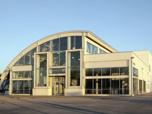
1 UPTOWN NORMAL RENEWAL PLAN NORMAL, ILLINOIS TOWN OF NORMAL The visionary Uptown Redevelopment Plan resulted from a collaboration between the Town of Normal, Illinois and Farr Associates. The community's downtown, known as Uptown, had been in a prolonged state of decline, marked by reduced retail choices and deferred building maintenance. An ambitions plan was undertaken to create a sense of place downtown, where there previously had been plaza anchored by an existing Amtrak facility. Well into its implementation phase, the redevelopment plan has far exceeded initial goals. The Uptown Circle has become a major civic attraction, with the added TIGER federal grant, a new multi-modal high speed rail facility replaced the undersized Amtrak station in A new hotel/conference facility and a LEED This redevelopment activity has spurred $211million in new private sector investment throughout the area and increased property values 73% since 2003.


2 HARPER COURT CHICAGO, ILLINOIS CITY OF CHICAGO & HARPER COURT PARTNERS In 2014 at the gateway to the 53rd Street retail corridor began. The corridor, which serves as the University of time in many years, and a Farr Associates' master plan for the area guided the redevelopment. A new, 3.1-acre multiphase development called Harper Court contains a Hyatt Place hotel property, a mixed-use condominiums, and streetscape improvements. 53,000 changes activated the corridor and transformed the pedestrian experience by adding activity where there were once vast parking lots. Farr Associates provided project developers with a Planned Development scheme that ultimately was chosen by the City of Chicago as the best for the site winning the team development rights for the project. Sustainability and innovation lie at the center of the plan, with Harper Court achieving LEED for Neighborhood


3 WORTH TOD PLAN WORTH, ILLINOIS RTA & VILLAGE OF WORTH of Worth, a Chicago south suburban community served by RTA Metra service. While the station is well-utilized, the station are is underdeveloped, consisting of mostly surface parking lots and inconsistent strip mall development. Two wide arterials also cross at the station area, acting as physical barriers. The Client sought assistance from Farr Associates to create a station area plan to guide more pedestrian-friendly and mixed use redevelopment in the area. A market analysis for the area concluded there was demand for up to 30,000 sf of new commercial and for strategically placed rental apartments. The master plan incorporates Street and Depot Avenue, as primary streets for strategic redevelopment for these new uses. As later redevelopment happens, it will spread to adjacent streets. The team developed a regulating plan to guide any new development in the station area. The new "TOD District" regulations that the surrounding area. Worth Regulating Plan


 that could be leased or sold in the")
4 Zimmerman / Volk Associates DOWNTOWN KALAMAZOO, MICHIGAN Description of Service: This study -examined the market potential for new urban housing units created both through adaptive re-use of existing non-residential buildings as well as through new construction that could be leased or sold in the core Downtown and in several surrounding in-town neighborhoods. The analysis covered the potential for both market-rate as well as workforce tion forecasts for both the downtown and the neighborhoods. DOWNTOWN SOUTH BEND, INDIANA Residential market analysis to determine the market introduced housing units (both new construction and adaptive re-use) that could be leased or sold in the A series of interviews were conducted with various derstanding of the barriers to new developments within Downtown South Bend. DOWNTOWN WICHITA, KANSAS Market analysis that provided a detailed analysis of residential conditions within Downtown. The study determined the market potential for newly-introduced housing units (both new construction and adaptive re-use) that could be leased or sold in the Downtown over the A series of interviews were conducted with various stakeholders knowledgeable about housing in general barriers to new developments within Downtown Wichita. An update to this study was recently completed.


5


6 ann arbor municipal center ann arbor, michigan The development of Ann Arbor s municipal center has transformed the aging civic complex into a pedestrianfriendly, dynamic green space that demonstrates the environmental, social, and economic bene ts of sustainable design. The re-imagined 2-acre civic campus is comprised of City Hall and most of the city s administrative services, as well as a new police and courts building. Rainwater art in plaza of Ann Arbor Municipal Center Designed to better serve the citizens of Ann Arbor, the nearby University of Michigan, and over 400 municipal employees, the site is a vibrant urban center with abundant garden spaces, plazas, picnic tables, public art and a green roof promenade. A large glass atrium creates a sense of openness in the new justice center, while a landscaped plaza provides a connection to City Hall. Several sustainable measures optimize the site s ecological performance, with the water and vegetation systems designed to help protect the nearby Huron River. The use of permeable pavement, rainwater planters and streetscapes, and a rain terrace serve multiple functions, including public seating and gathering space. These and other green infrastructure tools help slow, cleanse and cool rainfall on site, signi cantly reducing stormwater runo. Sculptural water features and runnels, some of which have been created by world-renowned artist Herbert Dreiseitl, display moving rainwater as an art form. ecorati e rain ar en capture tore an treat tor water runo client: City of Ann Arbor The path of rain water is displayed artfully using decorative runnels project team: completion: 2012 LEED: award: Conservation Design Forum Quinn Evans Architects InSite Design Studio Stantec Herbert Dreiseitl LEED Gold cost: $750,000 Michigan ASLA Award Conservation Design Forum Lombard, IL Ann Arbor, MI d n om


7 iowa green streets pilot project west union, iowa The Iowa Green Streets Pilot Project is an innovative community-wide sustainability initiative serving as a catalyst for further investment in the historic downtown of West Union, Iowa. The project began with a visioning workshop in October of 2007 when Iowa s Economic Development Authority (IEDA) completed a Technical Assistance Visit to advise West Union about the potential for multi-purpose pedestrian-scaled streetscape improvements. The result of the initial visioning and subsequent Conceptual and Schematic Planning was a Streetscape Master Plan which led to the Pilot Project which was completed in A new amphitheater hosts civic events and provides a focal point for downtown The innovative approaches applied in West Union include six blocks of a porous paving system that in ltrate, cleanse and cool storm water on site; 27,000 square feet of rain gardens; a district geothermal heating and cooling system connected to 60 downtown buildings; LED street lights; building energy audits and energy e ciency incentives; electric vehicle charging stations; improved walkability and accessibility; upper-story housing; public art; increased community awareness of sustainable practices; a community gathering plaza; and a research project studying the environmental, social and economic impacts of the project. Original brick pavers from 1914 were recovered and re-used in the intersections Porous paving and rain garden planters beautify the sidewallks client: project team: completion: 2013 awards: construction budget: City of West Union, Iowa Iowa Department of Economic Development Conservation Design Forum TeKippe Engineering IBC Engineering 1000 Friends of Iowa Best Development Award, 2014 Iowa ASLA Merit Award, 2015 $9.6 million Conservation Design Forum Lombard, IL Ann Arbor, MI nc.com

8 2 STATEMENT OF EEO PRACTICES PLAZA CIRCLE, MUNDELEIN, IL
9 STATEMENT OF EEO PRACTICES Farr Associates is an equal employment workplace, providing employment opportunities regardless of race, religion, gender, national origin, sexual orientation, or age. Farr Associates is committed to offering equal opportunity in all aspects of employment including recruitment, selection, retention, and promotion. Farr Associates agrees to the EEO terms provided in the RFP document.

10 3 SCOPE OF REQUIRED SERVICES NINETY7FIFTY ON THE PARK, ORLAND PARK, IL
11 SCOPE OF SERVICES West Chicago set a vision in 2007 for the Central- Main Street area to strengthen the links between Downtown, the Metra Station Area, and the Main Street/Route 59 area. Unfortunately, the timing for implementation lined up with the recession years. In the subsequent years, much has changed in everything approached. The 2007 Plan needs a fresh look and an injection of new ideas. Our approach is to work with the City, dialing down to what worked, what didn't, and what's new in the current market economy that impacts today's decision-making. We believe our team is the perfect partner for City in this endeavor. Farr Associates has been working successfully with municipalities and the development community for over 20 years to assist cities in attracting the quality development they seek through a combination of planning tools including incentives, regulations, and public private partnerships. We also are adept at convening and managing a team of consultants working in the real estate market, master planning, and stormwater management that this assignment requires. This scope is a starting point for a conversation with the City. All tasks are led by Farr Associates unless otherwise noted. Task 1.3: Kickoff Meeting & 2007 Plan Diagnosis Workshop The team will convene a joint kickoff and 2007 Plan Diagnosis meeting internally with the entire design team, City staff, interested Plan Commissioners, and any members of the City Council Development Committee or larger City Council interested in attending. The kickoff meeting will set a common base of understanding for the project's goals, perceptions, and schedule. From there, we will focus on an informal diagnosis of the 2007 Central-Main Street Redevelopment Plan. existing plan, including the strategies undertaken during the recession. We want to learn about the City-investments in the area (such as streetscaping), TIF District background, the decision making process behind land acquisition. We also want to hear the group's opinions about the newer development in the study area (such as the two developments on Main Street near the station). Most importantly, we want to hear the group's ideas and vision for the redevelopment plan. The design team will facilitate this interactive discussion and will provide all exhibits, maps, photographs, and other materials needed for this session. TASK 1: PROJECT INITIATION & DATA COLLECTION Task 1.1: Project Initiation The initial phase of the project serves to familiarize the consultant team with the study area, key planning documents, and existing zoning. This will be accomplished through detailed review of plans, codes, the Central-Main Street Redevelopment Plan, West Washington Street Plan, West Chicago Strategic Plan, CMAP Housing Study, and past development proposals in the area, among others. Task 1.2: Physical Survey The team will conduct a physical survey of the existing conditions of the study area to collect data related to existing physical conditions, land use, parcels, zoning, and economic issues. Task 1.4: 2007 Plan Evaluation Memo All information gathered during Task 1 will be compiled into a 2007 Plan Evaluation Memo. This document, which will have a heavy emphasis on graphics, will survey and highlight the issues and big ideas collected during the Plan Diagnosis Workshop. This summary will not be a report, rather, it will be framed using the existing conditions to pose questions the resulting Plan Update will answer. TASK 2: RESIDENTIAL MARKET ANALYSIS Task led by Zimmerman/Volk Associates ZVA is the premier urban market-rate residential analysis
12 methodology that looks at future housing demand, rather than simply studying existing demand. After their analysis of Downtown West Chicago, they will be able types, such as apartments, condos, townhomes, lofts, etc., and pair them with an expected unit demand and absorption forecast. They have a track record to back up their work in cities like Wichita, Kansas, and Kalamazoo, Michigan, where the unit demand came in at their established targets. For this analysis, ZVA will research and evaluate market activity and geo-demographic data relating to the City of West Chicago and the study area. The analysis will establish the depth and breadth of the market for new and existing dwelling units in the city and the Study Area (target market potential), as well as the housing rent and price levels (optimum market position) that will attract the draw area households. The scope of services will determine: Geographic areas for analysis: the study areas (the Central-Main Street Redevelopment Plan Update Study Area); the draw areas (where the potential renters and buyers of new and existing housing units in the City of West Chicago are likely to move from); and the West Chicago market area (the housing market context; relevant existing rental and for-sale housing units that represent alternatives to new housing in the Study Area). Target markets. Who currently lives in the draw areas and what they are like, and who would be likely to move within or to West Chicago and the Study Area. Market potential. How many are likely to move within or to the City of West Chicago and the Study Area if appropriate housing units were to be made available (depth and breadth of the market). Optimum residential mix. What the housing preferences are in aggregate (rental or ownership, multi-family or single-family) of the target markets for new housing in the Study Area. Optimum residential market position. What the target markets are able to pay to rent or purchase newly-created dwelling units within the Study Area. Absorption forecasts. How many new dwelling units can be leased or sold within the Study Area Task 2.1: Study Area Evaluation Zimmerman/Volk Associates will evaluate the characteristics, constraints and opportunities of the Central-Main Street Redevelopment Plan Update Study Area and its potential for new residential development. Residential opportunities will be assessed based on: The character of the Study Area that would represent opportunities for new mixeduse development Existing and potential amenities, including availability of (proximity to) employment, retail, transportation, medical institutions among other community amenities in or near the Study Area The potential position of the Study Area within the housing market context Residential market activity within areas germane to the Study Area and the City of West Chicago will be evaluated. Task 2.2: Target Residential Market Analysis To achieve the study objectives and establish the framework for analysis, Zimmerman/Volk Associates will employ its proprietary target market methodology. In contrast to traditional supply/demand analysis which is based on supply-side dynamics and baseline demographic projections target market analysis establishes the optimum market position for new housing based on the housing and lifestyle preferences areas that have the potential to move within or to the neighborhoods. The Competitive Context: Supply-Side Analysis Analysis of the competitive context, including information on relevant for-sale developments and relevant rental communities. Zimmerman/Volk Associates will evaluate the residential context in relation to potential residential or mixed-use development within the Study Area, based will be provided as follows: Summary of relevant market-rate rental multifamily properties in the West Chicago market area: building type, unit sizes and bedroom count, rents, amenities and occupancy rates, as available. Summary of relevant new market-rate for-sale multi-family properties, if any, in the market area: building type, unit sizes and bedroom count, prices, amenities and sales, as available. If there are no such properties, individual units listed through Multiple Listing Service will be compiled. Summary of relevant new market-rate for-sale single-family attached properties, if any, in the
13 market area: building type, unit sizes and bedroom count, prices, amenities and sales, as available. If there are no such properties, individual units listed through Multiple Listing Service will be compiled. Draw Area Delineation Zimmerman/Volk Associates will identify the appropriate draw areas for housing within the City of West Chicago and the Study Area, based on historical settlement patterns, migration and mobility trends, and other market dynamics. The data will cover the most Service has released data. Determination of Market Potential Zimmerman/Volk Associates will determine the depth and breadth of the potential market for the City of West Chicago and the Study Area through target market analysis of households in the draw areas, as follows: market group within the draw areas. households by relevant criteria including, among others, housing and neighborhood preferences and household mobility rates. areas with the potential to move within or to the City of West Chicago and to the Study Area over The potential market will be correlated by household group (empty-nesters/retirees, traditional and non-traditional families, younger singles/couples); by tenure (rental and ownership); by income; and by housing type (e.g. multi-family for-rent and for-sale {lofts/apartments}, singlefamily attached {rowhouses/townhouses/livework}). Determination Of Optimum Market Position Target market data and supply-side data, as well as existing conditions, constraints and opportunities will be correlated and analyzed in order to determine the optimum market position for the Central-Main Street Redevelopment Plan Update Study Area. Market recommendations will include: Housing types appropriate within the Study Area; The appropriate mix of rental and ownership units, based on target market tenure preferences and potential market; General price ranges (for market-rate ownership units); General rent ranges (for market-rate rental units); Appropriate unit and neighborhood amenities; and Annual market capture by value (price and rent) TASK 3: COMMERCIAL MARKET ANALYSIS, DEVELOPER ENGAGEMENT, & DEVELOPMENT INCENTIVE ANALYSIS Task led by BDI Task 3.1: Commercial Market Analysis Update Based on the Market Analysis, BDI will establish market rate investment standards for land, residential, retail, Task 3.2: Developer Engagement BDI will schedule and conduct developer interviews to gather responses and opinions from the development community about strategic questions regarding the Station Area North study area. The team will generate a developer list to be vetted and approved interviews will be conducted in person over targeted days in the Village. Some interviews will likely need to be scheduled as calls depending on the schedules and availability of participants. The framework for this investigation includes: redevelopment, with a focus on City-owned properties What locations in the Study Area offer the best chance for success? Identify reasons for the lack of development interest in the Study Area; generate ideas for attracting development the City staff, interested Plan Commissioners, and the City Council Development Committee on the results of the residential and market analysis. We will also Feedback from this meeting will inform next steps in the Land Use Update Task.
14 Task 3.4: Redevelopment Economic Analysis Using the review of the land use scenarios from the conditions, and if they did not, provided alternative land uses/site plan that would work better, BDI will determine the developer return on investment and annual municipal revenues inherent in the proposed development. If there is a gap between market rate investment returns and the returned expected from the recommended development, BDI recommend This task will be completed in conjunction with Task 4.3. Task 3.5: Economic Development Implementation Plan BDI will create an implementation plan that recommends an approach to the market for the developers who have successfully completed similar projects and a marketing approach for the overall project. Missing Middle Housing We will also pay special attention to any development products missing from the developer survey. In the Middle" housing types are absent from market conditions. These include a range of multi-unit or clustered housing types compatible in scale with single-family homes that help meet the demand for walkable urban living duplexes, triplexes, small apartment developments, live/work, and small lotsingle family. If we discover these housing types are missing from the market, we will work with City to develop strategies to attract their developers. Task 4.2 Three Schemes Workshop The team will lead a Three Schemes Workshop where the design team will present three redevelopment schemes to the group, illustrating the big ideas, his will be an interactive session, with real-time sketching and testing of ideas. We will record feedback from the group to use in narrowing the options to a preferred plan. TASK 4: LAND USE SCENARIOS UPDATE Task 4.1: Land Use & Three Redevelopment Concepts Armed with information from the existing conditions, the Diagnosis Workshop, the results of the market analyses, and the developer survey, the design team will develop three study area redevelopment concepts focusing on City-owned land. These three concepts will feature big and small ideas for redevelopment sites, based on development feasibility. We will bring an urbanist eye to this urban design and site planning work that promotes walkability in Downtown West Chicago. We will encourage buildings built close to the sidewalk and corners, smart solutions for increasing density, parking in the rear or sides of buildings, and a connected network of streets designed for multi-modal users. We balance these community's need for proximate parking, easy loading and delivery, and visible signage. These plans will be distributed to the City and other City leadership ahead of the Three Schemes Workshop (Task 4.2). 4.3 Preferred Scheme Concept Plan Based on feedback from the Three Schemes Workshops, the design team will develop a preferred land use and updated redevelopment plan for the study area. The preferred concept may be developed out of one popular scheme, or more likely, a combination of desired elements from multiple schemes. The plan will illustrate building footprints, parking locations, urban design elements and open space. It will break down the following information: Proposed Land Uses Target square footage numbers for new commercial space Target number of new dwelling units by type (condos, town houses, apartments, etc). Target density Target parking ratios Appropriate building types Open space recommendations Phasing & Implementation Information Task 4.4: Stormwater Management Evaluation Task led by CDF For the Preferred Scheme, CDF engineers and landscape architects will review all DuPage County
15 and City stormwater management requirements and will include probable costs of implementing the strategies, possible stormwater treatment locations, and determine if the original recommendations are still the best/most viable options. Task 5.3: Final Central-Main Street Plan Update be developed incorporating the feedback, comments, and revisions from the client review. Farr Associates requested by the City a reproducible document, including electronic copies. TASK 5: MAIN-CENTRAL PLAN UPDATE Task 5.1: Central-Main Street Plan Update Draft A draft Central-Main Street Plan Update will be developed made up of the deliverables of each prior task. The draft update will include sections based on: Existing Conditions Residential & Commercial Market Analyses Summary Developer Engagement Summary Preferred Scheme Concept Plan Zoning and Regulatory Recommendations Development Incentives Recommendations Stormwater Management Recommendations Phasing & Implementation Plan that clearly communicates the roles of City Council, City staff, and outside parties (stakeholders, the public, developers) in the plan implementation. The Plan Update will establish linkages with other City planning efforts, including the West Washington Street Plan and CMAP Housing Study. It will establish and maintain consistency of policies and recommended physical improvements among documents, and provide opportunities for connecting action steps from each. Task 5.4: Leadership Training In order to provide sustained project support, community leaders need to be able to articulate the when they are learning these things alongside the community. We propose up to two Leadership Training Sessions to give Board, Commission, and Council of the project, to hone their arguments, and ask questions. Task 5.5: RFP for Development Task led by Farr Associates with assistance from BDI If the City is interested, we will lead the development of a developer RFP for any of the redevelopment sites, in close coordination with the City. We will prepare We will present the draft RFQ/P document to the City The Draft Plan Update will be distributed to the City and other City leadership ahead of the Draft Plan Update Presentation (Task 5.2). Task 5.2: Draft Central-Main Street Plan Update Presentation The consultant team will present the Draft Plan Update to the City staff, interested Plan Commissioners, and the City Council Development Committee. The City will be responsible for collecting comments, suggestions, and questions from this meetings and consolidating them into a series of clear action items for Farr Associates revision or response.

16 4 PROPOSED SCHEDULE HARPER COURT REDEVELOPMPENT, CHICAGO, IL
17 PROPOSED SCHEDULE TASK OCT NOV DEC JAN '17 FEB MAR APR MAY JUN JUL 1.1 Project Initiation 1.2 Physical Survey S 1.3 Kickoff Meeting & 2007 Plan Diagnosis Workshop DW Plan Evaluation Memo EM EM Residential Market Analysis 3.1 Commercial Market Analysis Update 3.2 Developer Engagement 3.3 Market Analysis Briefing MB 3.4 Redevelopment Economic Analysis 3.5 Economic Development Implementation Plan FD 4.1 Land Use & Three Redevelopment Schemes 4.2 Three Schemes Workshop 3S 3S 4.3 Preferred Scheme Concept Plan 4.4 Stormwater Management Evaluation 5.1 Central-Main Street Plan Update Draft 1D 5.2 Draft Central-Main Street Plan Update Presentation PUP 5.3 Final Central-Main Street Plan Update FD 5.4 Leadership Training LT LT 5.5 RFP for Development RFP City Reivew Farr Associates Revisions Deliverable Draft

18 5 REFERENCES PRAIRIE CROSSING, GRAYSLAKE, IL
19 EXHIBIT B COMPANY REFERENCES Submit a completed client profile information sheet for each company reference. Provide a minimum of three references. 1. Client name: Village of Mundelein, Illinois 2. Address: 300 Plaza Circle 3. City, state, zip code: Mundelein, IL Project manager: Amanda M. Orenchuk, AICP 5. Telephone number: aorenchuk@mundelein.org 7. Number of employees in client organization: Following the adoption of the Village's Comprehensive 8. Project scope of services/goals: Plan, the Village sought to implement multiple strategies within their station area develop a master plan for the site focused on Mundelein's new Village Hall, urban design for the station area with the creation of Plaza Circle, and develop a phasing plan that would attract new private residential and mixed use development in the TOD area. 9. Contract award date: 1/2012 Cutover date: 8/ Initial contract amount: $ 150,000 Final contract amount: $ 150, Describe the project, its similarity to the services requested herein, and how goals were met: After purchasing a former industrial property, the Village owned 10.5 acres of prime transit-adjacent land and needed a strategy for redevelopment. Their recently adopted comprehensive plan called for creating a mixed use station area, which the community favored, but the Village wanted to ensure quality development and urban design in the area. 12. What were the costs of the project? Costs of the project included professional services fees for urban planning, market analysis, transportation planning, and civil engineering. 13. You may attach any reports or studies completed for the project. 12
20 EXHIBIT B COMPANY REFERENCES Submit a completed client profile information sheet for each company reference. Provide a minimum of three references. 1. Client name: Village of Tinley Park, Illinois 2. Address: South Oak Park Avenue 3. City, state, zip code: Tinley Park, IL Project manager: David Niemeyer 5. Telephone number: dniemeyer@tinleypark.org 7. Number of employees in client organization: Master plan for 200 acre site of former State of Illinois 8. Project scope of services/goals: campus adjacent to the 80th Street Metra Station. The project is serving to assist the Village with the decision of whether to purchase the site and lead the community through envisioning what new development and civic amenities could look like over the next 20+ years in the mostly built-out village. 9. Contract award date: 12/2015 Cutover date: Ongoing 10. Initial contract amount: $ 445,000 Final contract amount: $ Ongoing 11. Describe the project, its similarity to the services requested herein, and how goals were met: While the scale of the project is much larger than this assignment, the Farr Associates team worked with market consultants on extensive developer outreach to understand the products the development community believed would be successful on the site and how long absorption would likely take. We also noted what kinds of housing was missing from the survey and are developing strategies with the Village to encourage a diversity of housing types on the site. 12. What were the costs of the project? Costs of the project included professional services fees for urban planning, market analysis, developer outreach, transportation planning, and civil engineering. 13. You may attach any reports or studies completed for the project. 12
21 EXHIBIT B COMPANY REFERENCES Submit a completed client profile information sheet for each company reference. Provide a minimum of three references. 1. Client name: Town of Normal 2. Address: 100 E. Phoenix Ave 3. City, state, zip code: Normal, IL Project manager: Mercy Davison, AICP 5. Telephone number: (309) mdavison@normal.org 7. Number of employees in client organization: The charge from the Town in their planning services 8. Project scope of services/goals: RFP was "we want to do something in Uptown." Farr Associates crafted an award-winning plan that spurred $240 million in redevelopment activity over the next 16 years, including new mixed use residential, 2 new hotels, a museum, and the new Uptown Station, with no signs of slowing down yet. 9. Contract award date: 11/1999 Cutover date: 8/ Initial contract amount: $ 100,000 Final contract amount: $ 100, Describe the project, its similarity to the services requested herein, and how goals were met: development-attractive parcels in Uptown combined with prescriptive form-based design regulations of which, all but one has been redeveloped to date. This created the beloved Uptown Circle and surroundings that continue to spur private redevelopment activity nearby. 12. What were the costs of the project? Costs of the project included professional services fees for urban planning, market analysis, and transportation planning. 13. You may attach any reports or studies completed for the project. 12

22 6 COMPENSATION PROPOSAL UPTOWN CIRCLE, NORMAL, IL
23 EXHIBIT C COMPENSATION Submit a compensation proposal in a separate sealed envelope. The compensation shall be broken down by Plan Update component. 13
Tri-County Transportation & Land Use Study. Steering Committee Meeting May 14, 2009
 Tri-County Transportation & Land Use Study Steering Committee Meeting May 14, 2009 Agenda Recap of Study Goals and Objectives Update on CV Land Use Model: Business as Usual (BAU) Growth Scenario Pros vs
Town Center (part of the Comprehensive Plan)
") Town Center (part of the Comprehensive Plan) Mercer Island Town Center Looking North (2014) In 1994, a year-long process culminated in a set of design guidelines and code requirements for the Town Center
Town Center (part of the Comprehensive Plan) Mercer Island Town Center Looking North (2014) In 1994, a year-long process culminated in a set of design guidelines and code requirements for the Town Center
TOWN OF NEW CASTLE - Master Plan Update
 Our Presentation Today (1) Recap the Master Planning Process To Date (2) Present the Outline of the Master Planning Work Plan (3) Present the Calendar for the Master Plan (4) Outline the scope of a Downtown
New Partners for Smart Growth Conference February 5, 2010
 Dan Stroh, Planning Director City of Bellevue Planning and Community Development Bellevue, WA New Partners for Smart Growth Conference February 5, 2010 Summary of Project Long-range plan update for Bel-Red
CITY OF CHARLOTTESVILLE, VIRGINIA CITY COUNCIL AGENDA
 CITY OF CHARLOTTESVILLE, VIRGINIA CITY COUNCIL AGENDA Agenda Date: December 16, 2013 Action Required: Adoption of Resolution Presenter: Staff Contacts: Title: James E. Tolbert, AICP, Director of NDS James
Scope of Services. River Oaks Boulevard (SH 183) Corridor Master Plan
 Corridor Master Plan") Scope of Services River Oaks Boulevard (SH 183) Corridor Master Plan PROJECT AREA The project area consists of the River Oaks Boulevard (SH 183) corridor bounded by SH 199 at the northern end and the Trinity
Scope of Services River Oaks Boulevard (SH 183) Corridor Master Plan PROJECT AREA The project area consists of the River Oaks Boulevard (SH 183) corridor bounded by SH 199 at the northern end and the Trinity
1 October Dear Citizens of Charlotte and Mecklenburg County,
 1 October 2011 Dear Citizens of Charlotte and Mecklenburg County, As co-chairs of the Center City 2020 Vision Plan Steering Committee, we are proud to present the Center City 2020 Vision Plan, which sets
Welcome to the Oakridge Centre Open House
 Welcome to the Oakridge Centre Open House Why is the City hosting this event? This open house is to inform you of a rezoning application submitted to the City of Vancouver to amend the existing CD-1 (Comprehensive
PLAN ELEMENTS WORKSHOP. April 5, 2016
 PLAN ELEMENTS WORKSHOP April 5, 2016 needs more housing. But there is no one-size fits-all solution. Every neighborhood has its own character. In some places, density is not only appropriate it is badly
FUNDING CORRIDOR REVITALIZATION
 FUNDING CORRIDOR REVITALIZATION Integrated corridor planning for the 21 st Century America Planning Association Annual Conference Atlanta, GA April 27, 2014 Mariia Zimmerman, MZ Strategies, LLC mariia@mzstrategies.com
Chapter 1.0 Introduction
 Chapter 1.0 Introduction 1.1 Background The North Metro commuter rail line is part of the RTD FasTracks regional transit system expansion program to build more than 100 miles of rail transit throughout
City of Tacoma Planning and Development Services
 Agenda Item E-1 City of Tacoma Planning and Development Services To: Planning Commission From: Elliott Barnett, Planning Services Division Subject: Tacoma Mall Regional Center Subarea Plan and EIS Meeting
LEED-ND 101: Practical Strategies for Achieving Sustainability Goals. Travis Parker Lakewood Planning Director
 LEED-ND 101: Practical Strategies for Achieving Sustainability Goals Travis Parker Lakewood Planning Director Metro Vision Idea Exchange Oct 11, 2012 West Corridor Stations West Corridor Overview West
ANC 2A Presentation. November 9, 2006
 ANC 2A Presentation November 9, 2006 Introduction & Overview Applicants Boston Properties and KSI Services (project developers) The George Washington University (land owner) 2.66 acre site (former GW hospital
Lehigh Acres Land Development Regulations Community Planning Project
 Lehigh Acres Land Development Regulations Planning Effort Summary In July, 2010 Commissioner Frank Mann invited the Lehigh Acres community to start discussing how to achieve their recently adopted community
Atlanta BeltLine Subarea 3 Master Plan Update
 Atlanta BeltLine Subarea 3 Master Plan Update April 14, 2018 Workshop Meeting 1 22 miles, connecting 45 neighborhoods 22 MILES of transit 46 MILES of streetscapes and complete streets 33 MILES of urban
hermitage town center
 hermitage town center A Community Vision prepared by Strada for The City of Hermitage and The Mercer County Regional Planning Commission January 2007 table of contents introduction 3 design principles
FOUR MILE RUN VALLEY WORKING GROUP AND CHARGE
 FOUR MILE RUN VALLEY WORKING GROUP AND CHARGE Adopted April 16, 2016 Amended July 19, 2016 Overview of Integrated Effort The overall goal of the Four Mile Run Valley (4MRV) initiative is to develop a comprehensive
Request for Proposals: Architectural/Design Guidelines
 Request for Proposals: Architectural/Design Guidelines January 11, 2017 1.0 INTRODUCTION The City of Issaquah, Washington is soliciting proposals from qualified consulting firms to lead a community conversation
MALL REVITALIZATION CASE STUDIES
 MALL REVITALIZATION CASE STUDIES DECEMBER 9, 2012 MALL REVITALIZATION OVERVIEW Introduction Sample Case Studies prepared for Lacey Woodland District Steering Committee as it considers strategies to revitalize
Sewanee Village + Request for Builder/Developer Proposals
 Sewanee Village + Request for Builder/Developer Proposals Contact: Frank X. Gladu Special Assistant to the Vice Chancellor University of the South 735 University Ave Version 3 Sewanee TN 37383 Released:
Danvers High Street I-1 District Study
 Danvers High Street I-1 District Study Presentation of Final Recommendations Planning Board Presentation June 26 th, 2018 1 Introductions Metropolitan Area Planning Council Sam Cleaves AICP, Principal
Introduction. Chapter 1. Purpose of the Comprehensive Plan Plan Organization Planning Process & Community Input 1-1
 Chapter 1 Introduction Lakewood 2025: Moving Forward Together Purpose of the Comprehensive Plan Plan Organization Planning Process & Community Input 1-1 Purpose of the Comprehensive Plan The Comprehensive
ARLINGTON COUNTY, VIRGINIA
 ARLINGTON COUNTY, VIRGINIA County Board Agenda Item Meeting October 15, 2005 DATE: September 28, 2005 SUBJECT: Request to Advertise the adoption of the 2005 Clarendon Sector Plan C. M. RECOMMENDATION:
Official Plan Review
 Official Plan Review Summary Report - The Built Environment August 2014 Part 1: Introduction Planning for a healthy, prosperous and sustainable community is an important goal for our municipality. From
Gold Line Bus Rapid Transit Transit Oriented Development (BRTOD) Helmo Station Area Plan
 Helmo Station Area Plan") Appendix F Gold Line Bus Rapid Transit Transit Oriented Development (BRTOD) Helmo Station Area Plan Introduction and Purpose of the Plan The Gold Line Bus Rapid Transit facility is an eleven-mile dedicated
Appendix F Gold Line Bus Rapid Transit Transit Oriented Development (BRTOD) Helmo Station Area Plan Introduction and Purpose of the Plan The Gold Line Bus Rapid Transit facility is an eleven-mile dedicated
Plano Tomorrow Vision and Policies
 Plano Tomorrow Vision and Policies PLANO TOMORROW PILLARS The Built Environment The Social Environment The Natural Environment The Economic Environment Land Use and Urban Design Transportation Housing
7Page 91 CLEMMONS COMMUNITY COMPASS 7 COMMUNITY CHARACTER
 7 Community Character The beauty of Clemmons won t necessarily be a reflection of our past, but our future. This quote from Comprehensive Plan Steering Committee member Wayne Dodson captures the essence
Sustainability, Health, Safety, Recreation & Open Space Working Group August 3, 2017
 Sustainability, Health, Safety, Recreation & Open Space Working Group August 3, 2017 DOWNTOWN OAKLAND SPECIFIC PLAN WELCOME Sustainability, Health, Safety, Recreation & Open Space Working Group Social
Allen Street Civic District Redevelopment Area Plan Redevelopment Plan & Proposal State College Planning Commission State College Redevelopment
 Allen Street Civic District Redevelopment Area Plan Redevelopment Plan & Proposal State College Planning Commission State College Redevelopment Authority September 17, 2015 Discussion Points Overview of
DALY CITY VISIONING PROCESS COMMUNITY WORKSHOP 3 MAY 8, 2008
 DALY CITY VISIONING PROCESS COMMUNITY WORKSHOP 3 MAY 8, 2008 PROCESS General Plan - a statement of the community s values, vision and aspirations for now and into the future... Timeframe LONG TERM - 2030
SOUTH FLORIDA TOD GRANT UPDATE
 Palm Beach Transportation Planning Agency October 2018 SOUTH FLORIDA TOD GRANT UPDATE Presented by Treasure Coast Regional Planning Council in partnership with SFRTA & SFRPC What is Transit Oriented Development
PART 1. Background to the Study. Avenue Study. The Danforth
 The Danforth 1.1/ Study Purpose & Key Municipal Goals 1.2/ The Local Advisory Committee 1.3/ The Project Team 1.4/ Study Process/Summary of Method 1.5/ Summary of Consultation 1.1 Study Purpose and Key
TREASURE COAST REGIONAL PLANNING COUNCIL M E M O R A N D U M. To: Council Members AGENDA ITEM 5H
 TREASURE COAST REGIONAL PLANNING COUNCIL M E M O R A N D U M To: Council Members AGENDA ITEM 5H From: Date: Subject: Staff October 17, 2008 Council Meeting Local Government Comprehensive Plan Review Draft
TOWN COUNCIL / PLANNING COMMISSION
 Workshop #3 TOWN COUNCIL / PLANNING COMMISSION January 20, 2011 Consultant Team In Attendance Tonight BMS Design Group Nevada City and San Francisco Michael Smiley, AICP, ASLA Partner-in-Charge Nancy L.
Request for Statement of Interest in Implementation of the Roosevelt Road Redevelopment Plan
 425 Hillside Avenue Request for Statement of Interest in Implementation of the Roosevelt Road Redevelopment Plan I. INTRODUCTION The is seeking the services of a qualified consulting firm to prepare plans
ForwardDallas! Comprehensive Plan. City Council Briefing February 15, 2006
 ForwardDallas! Comprehensive Plan City Council Briefing February 15, 2006 Purpose Brief City Council on the preliminary products of the Forward Dallas! Comprehensive Plan 2 Where we are in the process
Request for Proposal
 Request for Proposal 10 th Street Corridor Master Plan Department of Planning and Zoning 500 Quartermaster Court Suite 200 Jeffersonville, IN 47130 April 18, 2017 For further information contact: Chad
ESTABLISH AN EFFICIENT TOWN CENTER
 ESTABLISH AN EFFICIENT TOWN CENTER 4 Overview Lisbon residents are proud of the history of Newent and at the same time recognize its current importance as a centralized location for a variety of municipal
North Fair Oaks Community Plan Summary and Information
 North Fair Oaks Community Plan Summary and Information WHAT IS THE NORTH FAIR OAKS COMMUNITY PLAN? The North Fair Oaks Community Plan is part of the San Mateo County General Plan, and establishes policies
Complete Neighbourhood Guidelines Review Tool
 Complete Neighbourhood Guidelines Review Tool Prepared By: City of Regina Planning Department October 2014 Page 1 of 14 Community Development Review Checklist for Secondary Plans and Concept Plans The
DRAFT PLAN PRESENTATION
 DRAFT PLAN PRESENTATION 1.23.2018 AGENDA Process Project Schedule Results from Visioning Workshop Draft Plan Highlights Concept Plans Feedback Next Steps PROJECT SCHEDULE KICK-OFF WORKSHOP August 29 th
Market Demand and Land Use
 Market Demand and Land Use Summary 57 Challenges 60-61 Guiding Principles 62 Strategy and Implementation 63-69 Establish a mix of uses that contribute to a vibrant downtown. 58 Summary Historically, downtown
Implementation Guide Comprehensive Plan City of Allen
 Implementation Guide 2030 Comprehensive Plan City of Allen DRAFT 2015 Implementation Guide Allen 2030 Comprehensive Plan INTRODUCTION The Comprehensive Plan serves as a guide for the growth and development
Economic Development & Housing Council Committee Comprehensive Plan Update September 20, 2005
 1 Economic Development & Housing Council Committee Comprehensive Plan Update September 20, 2005 Purpose To update the Committee on the ForwardDallas! Plan, including: Status Anticipated Products Public
Beaverton City Council: Work Session. SIDEDistrict. May 6, 2014
 BEAVERTON Beaverton City Council: CREEK Work Session SIDEDistrict May 6, 2014 Tonight s Agenda BEAVERTON CREEK SIDE Brief updates Creekside Vision Scenarios & discussion: Redevelopment & Parking Project
Prosperity Hucks Area Plan. Transportation and Planning Committee May 11, 2015
 Prosperity Hucks Area Plan Transportation and Planning Committee May 11, 2015 Presentation Outline 1. Background and Location 2. Community Dialog Process 3. Activity Center Recommendations 4. Wedge Recommendations
THAT the attached Terms of Reference for the Thornhill Centre Street Study be approved.
 COMMITTEE OF THE WHOLE AUGUST 18, 2003 THORNHILL CENTRE STREET STUDY PLANNING FILE: 15.92 Recommendation The Commissioner of Planning recommends: THAT the attached Terms of Reference for the Thornhill
NEC of Central Avenue and Indian School Road
 NEC of Central Avenue and Indian School Road For this location, there are two applicable plans that provide guidance on development. The two plans include the Indian School Specific Plan (1991) and the
PINE CURVE REZONING. Property does not meet criteria for open space preservation and is not a candidate for a park
 PINE CURVE REZONING BACKGROUND Purchased as two parcels in 2001 and 2002 Annexed and Zoned Greater Downtown District Historic Center September 25, 2002 and October 7, 2002 WHAT THE PROJECT IS AND IS NOT
Urban Planning and Land Use
 Urban Planning and Land Use 701 North 7 th Street, Room 423 Phone: (913) 573-5750 Kansas City, Kansas 66101 Fax: (913) 573-5796 Email: planninginfo@wycokck.org www.wycokck.org/planning To: From: City Planning
Small Area Plan. South Gateway
 Small Area Plan Adopted May 12, 2008 South Gateway Purpose. The South Gateway Small Area Plan defines the City s expectations for the future of the southern entrance to the City at Interstate 85 and Highway
JANUARY 19, 2011 CENTRAL AVENUE-METRO BLUE LINE TRANSIT-ORIENTED DEVELOPMENT IMPLEMENTATION PROJECT COMMUNITY FORUM
 CENTRAL AVENUE-METRO BLUE LINE TRANSIT-ORIENTED DEVELOPMENT IMPLEMENTATION PROJECT COMMUNITY FORUM JANUARY 19, 2011 THE MARYLAND-NATIONAL CAPITAL PARK AND PLANNING COMMISSION PRINCE GEORGE S COUNTY PLANNING
REZONING GUIDE. Zone Map Amendment (Rezoning) - Application. Rezoning Application Page 1 of 3. Return completed form to
 - Application. Rezoning Application Page 1 of 3. Return completed form to") Zone Map Amendment (Rezoning) - Application COMMUNITY PLANNING & DEVELOPMENT REZONING GUIDE Rezoning Application Page 1 of 3 PROPERTY OWNER INFORMATION* CHECK IF POINT OF CONTACT FOR APPLICATION Property
Zone Map Amendment (Rezoning) - Application COMMUNITY PLANNING & DEVELOPMENT REZONING GUIDE Rezoning Application Page 1 of 3 PROPERTY OWNER INFORMATION* CHECK IF POINT OF CONTACT FOR APPLICATION Property
CITY OF FARGO PARKING RAMP SITE EVALUATION
 CITY OF FARGO PARKING RAMP SITE EVALUATION EXECUTIVE SUMMARY Helenske Design Group (architect) and Carl Walker Inc (Parking Consultant) were retained by the City of Fargo to complete a downtown parking
INSTITUTIONAL USE DESIGN COMPATIBILITY TECHNIQUES
 INSTITUTIONAL USE DESIGN COMPATIBILITY TECHNIQUES INTRODUCTION Community institutions are an important part of the character and vitality of neighborhoods in Forsyth County. Institutional uses include
City of Farmington. Downtown Plan. Amendment to the 1998 Master Plan Adopted October 11, 2004
 City of Farmington Amendment to the 1998 Master Plan Adopted October 11, 2004 Introduction Planning Background 1 Scope and Components of the Plan Amendment 2 Concept Introduction 3 Plan Concepts 3 Conceptual
The Five Components of the McLoughlin Area Plan
 The Five Components of the McLoughlin Area Plan This documents contains the complete language of the five components of the McLoughlin Area Plan: The Vision Statement The Values The Guiding Principles
Developer s Program. The Station at East 54
 Developer s Program The Station at East 54 Existing Conditions The Station at East 54 is proposed for a 1.12 acre site at the northeast corner of Hamilton Road and Prestwick Road, tucked between the East
TEMPLE MEDICAL & EDUCATION DISTRICT
 City of Temple, Texas TEMPLE MEDICAL & EDUCATION DISTRICT 1 Description. The City of Temple joined in partnership with key public and private entities to jointly promote education and medical activities
About Momentum Midland
 About Momentum Midland Achieving a community s full potential in terms of economic development and quality of life is critically important to its long term sustainability. Core to achieving this is a vibrant
Roanoke Rapids Streetscape Master Plan. City Council Presentation
 SCHEDULE: Stakeholder Meeting/Kick off November,2016 Master Planning Phase (November March 2017) Public Meeting #1 December 13, 2016 Review Meeting with Key Stakeholders Refine Concepts Based on Input
PINE CURVE REZONING. BACKGROUND Purchased as two parcels in 2001 and 2002
 BACKGROUND Purchased as two parcels in 2001 and 2002 WHAT THE PROJECT IS AND IS NOT A Rezoning establishes the land use standards for Annexed and Zoned Greater Downtown District Historic Center September
ARISE: The Rock Renaissance Area Redevelopment & Implementation Strategy
 2014 Professional Awards 1 ARISE: The Rock Renaissance Area Redevelopment & Implementation Strategy Janesville, WI Completed December 2014 Analysis & Planning Purpose of Project 2 The purpose of the Rock
Staff Report to the North Ogden City Planning Commission
 Staff Report to the North Ogden City Planning Commission SYNOPSIS / APPLICATION INFORMATION Application Request: Concept review on a legislative application to rezone land located at approximately 1750
K. SMART ASSOCIATES LIMITED
 Planning Justification Report Zoning By-Law Amendment 185 King Street North Waterloo, Ontario April 7th, 2017 Project Reference Number 16-245 K. SMART ASSOCIATES LIMITED CONSULTING ENGINEERS AND PLANNERS
Welcome! to Keller Town Hall
 Welcome! to Keller Town Hall Keller Town Center Planning a New Downtown What is Keller Town Center? A new, growing downtown district planned as an urban village A combination of retail and office spaces,
City of Heath. Town Center Concept
 In the give-and-take of getting projects designed, financed, and approved, the famous refrain from the film Field of Dreams is heard often: if you build it, they will come. From the perspective of the
Additional information about land use types is given in Chapter 5. Design guidelines for Centers and Neighborhoods are given in Chapter 7.
 4. Place Types Introduction In Albemarle County s Development Areas, the Neighborhood is the fundamental unit of community planning. The County s Neighborhood Model, an adopted part of the Comprehensive
V. Vision and Guiding Principles
 V. Vision and Guiding Principles The Master Plan for the Powers Ferry Corridor seeks a foundation in the desires of the community. At times, various elements of the community offered opposing viewpoints,
EXHIBIT A. Tax Increment Reinvestment Zone No. 1 (Town Center) First Amended Project Plan 1
 First Amended Project Plan 1") EXHIBIT A Tax Increment Reinvestment Zone No. 1 (Town Center) First Amended Project Plan 1 1 As amended by Resolution No. 2008-02-001(TR1R) of the Tax Increment Reinvestment Zone No.1, and approved to
EXHIBIT A Tax Increment Reinvestment Zone No. 1 (Town Center) First Amended Project Plan 1 1 As amended by Resolution No. 2008-02-001(TR1R) of the Tax Increment Reinvestment Zone No.1, and approved to
2030 Comprehensive Plan VISION STATEMENT
 RESOURCE DOCUMENT for Steering Committee Meeting #2 July 12, 2017 2030 Comprehensive Plan VISION STATEMENT Steering Committee from 2008 Established the Lauderdale s Vision as: Creating a livable, lovable
IMAGINE CLEARWATER. Community Workshop 3. November 2016
 IMAGINE CLEARWATER Community Workshop 3 November 2016 Imagine Clearwater has been a 6-month community-focused process to re-envision the downtown waterfront. VISIONING FRAMEWORK MASTER PLAN HOW CAN WE
EXISTING COMPREHENSIVE PLAN
 EXISTING COMPREHENSIVE PLAN Town Center Land Use Element: V. LAND USE POLICIES Town Center Mercer Island's business district vision as described in "Your Mercer Island Citizen-Designed Downtown" was an
Transportation. Strategies for Action
 Transportation A major priority for the Overlake Neighborhood is to develop a multimodal transportation system. To achieve this system, a balance has to be found among travel, circulation and access needs;
WELCOME TO THE CHOUTEAU GREENWAY ECONOMIC DEVELOPMENT WORKING GROUP!
 WELCOME TO THE CHOUTEAU GREENWAY ECONOMIC DEVELOPMENT WORKING GROUP! Chouteau Greenway Steering Committee and Working Groups Overview Overview January 9, 2019 Chouteau Greenway will transform St. Louis
A BLUEPRINT FOR BROCKTON A CITY-WIDE COMPREHENSIVE PLAN
 A BLUEPRINT FOR BROCKTON A CITY-WIDE COMPREHENSIVE PLAN Public Meeting October 2016 1 Plan Summary and Discussion Public Meeting May 4 2017 City of Brockton Bill Carpenter, Mayor Department of Planning
REQUEST FOR PROPOSAL DOWNTOWN MASTER PLAN & PARKING STUDY CITY OF MONROE, MICHIGAN
 REQUEST FOR PROPOSAL DOWNTOWN MASTER PLAN & PARKING STUDY CITY OF MONROE, MICHIGAN RESPONSES ARE DUE: 10:00AM, TUESDAY, SEPTEMBER 5, 2017 CITY OF MONROE OFFICE OF THE CITY CLERK/TREASURER 120 EAST FIRST
D-O LRT Zoning Discussion. Chapel Hill Boards & Commissions October 16, 2017
 D-O LRT Zoning Discussion Chapel Hill Boards & Commissions October 16, 2017 Update on Overall D-O LRT Station Area Initiative Objectives Design and educate on principles of Good Transit-Oriented Development
BROOKLYN PARK / 85TH AVE LRT STATION CDI DEVELOPMENT GUIDELINES DRAFT
 August 2018 Page intentionally left blank The Brooklyn Park Library adjacent to the 85th Ave LRT Station Area. OVERVIEW The Blue Line LRT Extension / Bottineau corridor offers a unique opportunity to leverage
Harlem Avenue Corridor Plan: Corridor Planning Across Municipal Boundaries
 Harlem Avenue Corridor Plan: Corridor Planning Across Municipal Boundaries Heather Tabbert, Manager, Local Planning and Programs Division Regional Transportation Authority (RTA) Jen McNeil Dhadwal, Principal
CDAC. Update: Downtown Dartmouth Update: CDAC July 25 th Motion
 CDAC Update: Downtown Dartmouth Update: CDAC July 25 th Motion 2018-10-24 Downtown Dartmouth Plan Open House October 22, 2018 6:00 pm Open House 6:30 pm Presentation + Q&A 7:20 pm Open House 8:30 pm Close
The Village of Shirlington
 The Village of Shirlington Suburban Smart Growth Without Rail Transit July 2018 Agenda History (1940 to present) Attributes and Outcomes Lessons Learned Setting the Stage Arlington County Arlington is
Great Plans for a Great City
 CHAPTER 1 Great Plans for a Great City 1 Figure 1.1 South Michigan Avenue today Figure 1.2 South Michigan Avenue will be one of many higher intensity, mixed-use corridors that will extend out from the
Plan Overview. Manhattan Area 2035 Reflections and Progress. Chapter 1: Introduction. Background
 Plan Overview The Manhattan Urban Area Comprehensive Plan (the Comprehensive Plan) is a joint planning initiative of the City of Manhattan, Pottawatomie County, and Riley County. The 2014 Comprehensive
Secrest Short Cut and Monroe Expressway Small Area Plan AUGUST 29, 2018
 Secrest Short Cut and Monroe Expressway Small Area Plan AUGUST 29, 2018 Background and Process Monroe Expressway will be open by the end of 2018 Union County and Indian Trail identified a need to revisit
VILLAGE OF BOLTON HERITAGE CONSERVATION DISTRICT PLAN
 Page 1 1. INTRODUCTION AND BACKGROUND 1.1 THE PROJECT VILLAGE OF BOLTON HERITAGE CONSERVATION DISTRICT PLAN TERMS OF REFERENCE The Town of Caledon (Town) is a large, predominantly rural municipality with
Table of Contents. Elm Avenue Improvement Plan City of Waco, Texas. Introduction 1. Existing Context 1 Figure 1 2.
 Table of Contents Introduction 1 Existing Context 1 Figure 1 2 Plan Guidelines 3 Future Urban Form 4 The West-End 4 Main Street 6 The East-End 7 Figure 2 9 Public Improvement Recommendations 7 General
TOD 101 CREATING LIVABLE COMMUNITIES WITH TRANSIT
 1 CREATING LIVABLE COMMUNITIES WITH TRANSIT What are transit Centered Communities? Benefits of Partnerships to Support and Implement What You Will Learn Portland s Pearl District Your Trainers Today Catherine
University of Saskatchewan CAMPUS MASTER PLAN. Senate Meeting Preliminary Presentation. April 21, 2018 DIALOG ECS DA WATT
 University of Saskatchewan CAMPUS MASTER PLAN Senate Meeting Preliminary Presentation April 21, 2018 DIALOG ECS DA WATT project process presentation agenda Stakeholder Engagement Project Control phase1
IMPLEMENTING SOMERSET COUNTY S INVESTMENT FRAMEWORK
 IMPLEMENTING SOMERSET COUNTY S INVESTMENT FRAMEWORK SMART CONSERVATION THROUGH SMART GROWTH NJ LAND CONSERVATION RALLY March 22, 2014 Laurette Kratina, PP, AICP, Supervising Planner Somerset County Planning
MOBILITY HUB GUIDELINES 2012 TAC Sustainable Urban Transportation Award Submission BACKGROUND MOBILITY HUB GUIDELINES
 MOBILITY HUB GUIDELINES 2012 TAC Sustainable Urban Transportation Award Submission BACKGROUND Rapid population growth, increasing congestion, and years of under investment in transit in the Greater Toronto
THE TOWN OF WASAGA BEACH
 THE TOWN OF WASAGA BEACH Downtown Development Master Plan Committee of the Whole Presentation January 26 th 2017 Uses within this designation should reflect a dependence on tourism as opposed to the permanent
arts, culture & Entertainment district
 arts, culture & Entertainment district how we got here, and where we are going Creating an East Sherman Avenue Master Plan to revitalize the eastern gateway of the city is a spotlight project of the CDA
Policies and Code Intent Sections Related to Town Center
 Policies and Code Intent Sections Related to Town Center The Town Center Vision is scattered throughout the Comprehensive Plan, development code and the 1994 Town Center Plan. What follows are sections
Kensington Center. Public Meeting # Transit-Oriented Development, Town of Berlin, CT
 Kensington Center Public Meeting #1 10.27.16 Transit-Oriented Development, Town of Berlin, CT CivicMoxie 2016 What is Transit-Oriented Development Definition: Transit-Oriented Development (TOD) = is an
A. WHAT IS A GENERAL PLAN?
 I. Introduction A. WHAT IS A GENERAL PLAN? A general plan is the planning guideline for the future of a city. It contains goals and policies which regulate urban development, the protection of the natural
WELCOME TO THE CHOUTEAU GREENWAY EQUITY WORKING GROUP!
 WELCOME TO THE CHOUTEAU GREENWAY EQUITY WORKING GROUP! Chouteau Greenway Steering Committee and Working Groups Overview Overview January 9, 2019 Chouteau Greenway will transform St. Louis by connecting
WATERFORD Plan of Preservation, Conservation and Development Supplement Part 1 - Policy Element
 WATERFORD 2012 Plan of Preservation, Conservation and Development 2015 Supplement Part 1 - Policy Element Effective June 11, 2015 2015 Plan Update GOAL To respond to the evolving land use needs and continually
Hopkins. Development Guidelines May Overview. Sponsored by: Blake Road Corridor Collaborative City of Hopkins
 Hopkins Blake Road LRT Station Area Development Guidelines May 2015 Sponsored by: Blake Road Corridor Collaborative City of Hopkins Overview Hopkins is a dynamic community of over 17,000 residents located