MAYFIELD VILLAGE MASTER PLAN
|
|
|
- Morris Ray
- 5 years ago
- Views:
Transcription


1 MAYFIELD VILLAGE MASTER PLAN GOALS & ACTIONS
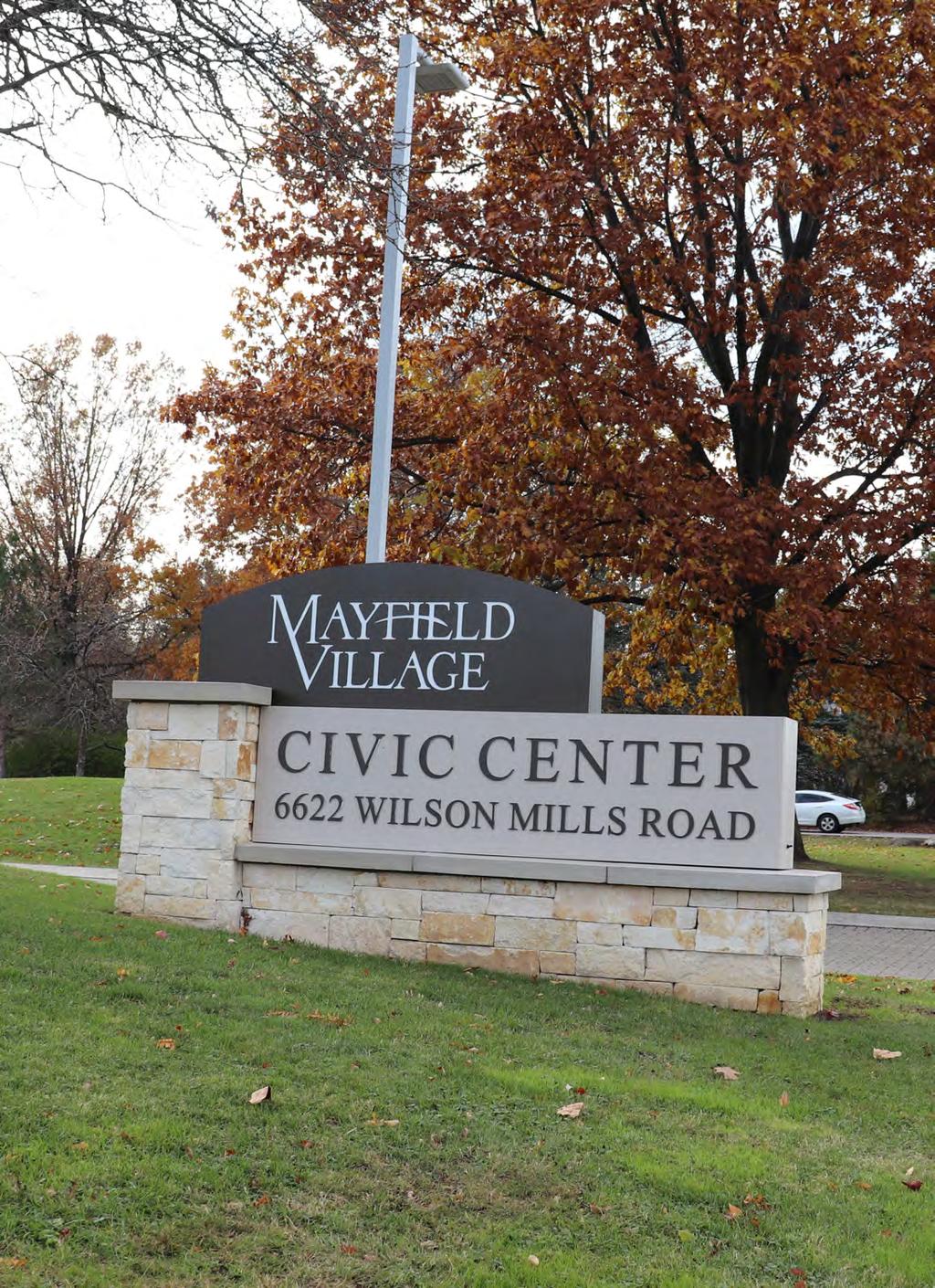
2 ACKNOWLEDGMENTS MAYFIELD VILLAGE Brenda T. Bodnar, Mayor Joseph Saponaro, Council President William Marquardt, Council Member Patsy Mills, Council Member Dr. Stephen Parker, Council Member George Williams, Council Member Allen Meyers, Council Member, At Large Steve Schutt Council Member, At Large STEERING COMMITTEE Michael Barnes Stivo DiFranco Rosemarie Fabrizio Jim Farmer Rick Hall Bob Haycox Kevin McGrath Joanna McNally John Michalko Tony Panzica Ed Parker Mary Singer Greg Tarkowsky Bert Toth PROJECT TEAM Brenda T. Bodnar, Mayor Diane Wolgamuth, Director of Administration Ronald C. Wynne, Director of Finance Douglas Metzung, Service Director Shane McAvinew, Parks & Recreation Director John Marrelli, Building Commissioner MAYFIELD VILLAGE 6622 Wilson Mills Rd Mayfield Village, Ohio
3 COUNTY PLANNING The Cuyahoga County Planning Commission s mission is to inform and provide services in support of the short and long term comprehensive planning, quality of life, environment, and economic development of Cuyahoga County and its cities, villages and townships. PLANNING TEAM Glenn Coyne, FAICP, Executive Director James Sonnhalter, Manager, Planning Services Dan Meaney, GISP, Manager, Information and Research Micah Stryker, AICP, Planner Kevin Leeson, Planner Rachel Novak, Planner Robin Watkins, Geographic Information Systems Specialist Torayye Waite, Planning Intern Nate Weyand-Geise, Planning Intern CUYAHOGA COUNTY PLANNING COMMISSION 2079 East 9th Street Suite Cleveland, OH


4
5 TABLE OF CONTENTS INTRODUCTION, PAGE 7 CORE THEMES & PRINCIPLES, PAGE 11 PLACE-BASED FRAMEWORK, PAGE 17 VILLAGE-WIDE FRAMEWORK, PAGE 33

6
7 1.0 WELCOME TO THE MASTER PLAN - GOALS & ACTIONS DOCUMENT The Mayfield Village Master Plan is a statement of community aspirations designed to inspire and guide Village officials and residents as they move the community into the future. By writing down these aspirations, the Plan memorializes the hopes of the community and, more importantly, outlines the steps necessary to achieve its goals. The Master Plan examines the current conditions throughout the Village, and develops a profile to determine the issues and trends that are shaping the community today. This helps to determine which trends should be fostered for the future and which need to change. These trends and the input of the public help determine the vision for the future that are outlined within the Master Plan. This vision is uniquely tailored to the community s goals for the future. Based on the current conditions, public input, and vision for the future, the Master Plan outlines specific steps that can be taken communitywide and within specific focus areas to deliver the changes residents wish to see. These ideas range from small changes that can enhance daily life in Mayfield Village, to large changes that may take several years and/or further planning to implement. CURRENT PHASE The Mayfield Village Master Plan is presently in the Goals & Actions phase. This is the third phase of the Plan; it articulates specific steps the Village and its partners can undertake to achieve the Community Vision developed and outlined in the previous phase. The Goals & Actions document builds out the Master Plan framework by grouping actions into Place-Based interventions as well as general Village-wide actions that can be taken. These actions will be reviewed and updated with additional input. NEXT STEPS Following completion of the Goals & Actions phase, the Master Plan will begin the Implementation phase. In this phase, the Plan outline partners, priorities, and funding sources that can be used to help accomplish the actions outlined within this document. The Mayfield Village Master Plan marks the beginning of this transformative process. It is intended to guide changes over many years and only with the dedicated work of residents, business owners, and Village staff can the Master Plan s goals be achieved.
8 8 Introduction
9 MASTER PLAN FRAMEWORK The Master Plan is structured so that all the recommended Goals & Actions point to and support the overall Community Vision. The hierarchy (shown below) ensures that actions support other actions and support the Vision Themes & Principles developed by the community in the Visioning Phase of the planning process. Goals & Actions are further organized by a Place Based Framework, that includes recommendations that are for specific physical locations in the Village, and a Community Wide Framework, that includes actions and policies that should be applied throughout the Village and considered with any new project or development. COMMUNITY VISION STATEMENT The overarching vision statement describing community in the future CORE THEMES & PRINCIPLES The Core Themes & Principles are the foundational ideas of the plan and are the basis for all the Goals & Actions GOALS & ACTIONS The Goals & Actions are the specific steps to achieve the Vision. They are broken into Place-Based and Villagewide Goals & Actions PLACE-BASED FRAMEWORK VILLAGE-WIDE FRAMEWORK The Place-Based Framework outlines Goals and Actions for specific areas of the Village The Village-wide Framework outlines the Goals and Actions that are more general and apply to the Village as a whole MAYFIELD VILLAGE MASTER PLAN 9

10
11 2.0 WHAT S INSIDE This section covers the three Core Themes and their four corresponding Principles. These were identified throughout the Current Conditions analysis and through input from residents and community stakeholders. Vision Themes & Principles cover a wide range of topics, describing how a community and its residents would like to get around, where they would like to recreate, how they would like to interact with government, and what types of new investments they would like to see. These principles are broad descriptions of how the community would like to look and function in five to ten years. CORE THEMES & PRINCIPLES Core Theme: Connected Community, page 12 Core theme: Thriving Economy, page 13 Core Theme: A Place to Call Home, page 14 The Core Themes and Guiding Principles in this section were developed through discussion and feedback from the Project Team and the Steering Committee to ensure they encapsulate the values and desired outcomes for the Village. HOW DO I USE IT? The Vision Themes & Principles section describes the desired future for Mayfield Village. They should be used as the basis for undertaking future actions. The Vision Principles are the foundation for all of the Goals and Actions that are proposed in the Plan. COMMUNITY VISION STATEMENT CORE THEMES & PRINCIPLES GOALS & ACTIONS PLACE-BASED FRAMEWORK VILLAGE-WIDE FRAMEWORK


12 2.0 CORE THEME: A CONNECTED COMMUNITY 1 SAFE & EFFICIENT TRANSPORTATION 2 CONNECTIVITY Traffic management and mitigation investment Quality, well maintained infrastructure Increased pedestrian and bike infrastructure on streets and at intersections Regional cooperation on transportation issues A well connected, multi-modal community supporting pedestrians, bikes, transit, and auto transportation Infrastructure and safety enhancements to encourage walking and biking Complete neighborhood sidewalk network Walkable areas supporting community engagement and economic development 3 CAPITAL IMPROVEMENTS 4 ENGAGED & CONNECTED CITIZENS Village infrastructure projects are a priority, especially streets, intersections, water, sewer, & civic buildings Seek out regional, State, and Federal funding Purchase land for preservation or Village facilities Regional leader in implementing innovative transportation or environmental infrastructure Increased community programs and events to engage residents Inter-organizational cooperation and collaboration Increased efforts at community outreach and information dissemination Increased on-line community engagement 12 Core Themes & Principles


13 CORE THEME: A THRIVING ECONOMY 1 BUSINESS DEVELOPMENT & GROWTH 2 INNOVATION Focus on the attraction and retention of high quality jobs and businesses Develop and support local small businesses Village investment in technology and infrastructure for businesses Facilitate redevelopment on Beta Drive Invest in technology infrastructure Attract businesses in research, technology, and energy, Invest in workplace training and education Implement modern and responsive zoning regulations 3 BEAUTIFUL & WELCOMING 4 REGIONAL LEADERSHIP Design standards for development and public spaces Village branding to promote a consistent identity Enhance the streetscapes of major corridors (signage, light poles, benches, banners, etc.) Enhance landscaping and street trees Promote the Village as regional business location Lead the way in working to address regional issues Promote cooperation and consolidation where appropriate Implement regional demonstration projects in infrastructure and government operations Engage the business community to promote the region MAYFIELD VILLAGE MASTER PLAN 13


14 2.0 CORE THEME: A PLACE TO CALL HOME 1 A PLACE TO LIVE FOR A LIFETIME 2 PRIORITIZING GREENSPACE, PARKS, & RECREATION Housing options for all ages and stages of life Seek opportunities to strengthen and expand Village services Development focus on healthcare, recreation, and livability Park amenities and recreation programs for all ages Protect existing undeveloped land Enhance the amenities at existing parks Increased recreational offerings Enhanced recreational facilities Connect neighborhoods to parks and greenspace Preserve or restore environmental functions through green infrastructure and development regulations 3 SAFE & VIBRANT NEIGHBORHOODS 4 EXCEPTIONAL VILLAGE SERVICE Strong housing stock and code enforcement Pedestrian and bike infrastructure for safe streets Community events and outreach Neighborhood greenspace Recreation programs that promote healthy and active lifestyles ADA compliant upgrades to Village facilities Enhanced and expanded Village services to meet resident and business needs Promote and employ green and sustainable practices Regional collaboration on government and safety services for efficiency and cost savings 14 Core Themes & Principles


15 MAYFIELD VILLAGE MASTER PLAN 15

16
17 3.0 WHAT S INSIDE The Place-Based Framework section describes actions and policies targeted to specific locations in the Village. This is the core strategy for how Mayfield Village should prioritize actions in the coming years. The section includes a map of the overall framework and then specific descriptions of each framework component. The Place-Based Framework is based on input from the Public, Steering Committee, and Project Team, which showed a desire to strengthen existing Village connections while providing enjoyable and sustainable community spaces. This evolved from the Focus Areas that were displayed at the first Public Meeting as particular components became more or less important to residents. PLACE-BASED FRAMEWORK Enhance Key Intersections: SOM Center Road & Wilson Mills Road, page 22 Beta Drive & Wilson Mills Road, page 24 SOM Center Road & Hickory Hill Drive, page 26 Improve Pedestrian & Bicycle Connectivity Along Wilson Mills Road, page 28 Enhance Beta Drive, page 30 HOW DO I USE IT? The Place-Based Framework section outlines particular locations of focus for the Master Plan. It should be used as a guide for where to target investments and how those investments should be layered together to support a larger framework for neighborhood improvement. The Place-Based Framework is the first half of the Plan s Goals & Actions. COMMUNITY VISION STATEMENT CORE THEMES & PRINCIPLES GOALS & ACTIONS PLACE-BASED FRAMEWORK VILLAGE-WIDE FRAMEWORK
18 3.0 WHAT IS THE FRAMEWORK? The Place-Based Framework identifies a series of areas and corridors that should be the focus of investment. The Framework is intended to show how investments made within these areas and corridors would link together to form a vibrant and connected Mayfield Village that matches the Vision Statements outlined by the community. WHY THIS FRAMEWORK? At the first Public Meeting, attendees were shown potential focus areas and corridors. Following input on those areas and corridors, specific components and areas were identified as more important to residents than other areas. The Place- Based Framework builds on the input from attendees to target the most important areas. The map to the right showcases the overall Place-Based Framework, while smaller maps on the following pages show the individual components of that Framework and how they fit together. 18 Place-Based Framework
19 Map 1 PLACE-BASED FRAMEWORK Willoughby Hills highland road Beta drive SOM Center road Highland Heights Wilson Mills road Gates Mills 271 Mayfield Heights LEGEND Intersection Enhancements/Improvements Community Sidewalk Connections First Priority Community Sidewalk Connections Second Priority Wilson Mills Road & Beta Drive Pedestrian and Bicycle Improvements MAYFIELD VILLAGE MASTER PLAN 19
20 3.0 Willoughby Hills 1: ENHANCE KEY INTERSECTIONS & VILLAGE CENTER highland road SOM Center road There are a number of intersections within Mayfield Village that play a significant role in moving people throughout the community and to various destinations. The Plan recommends focusing efforts on improving the intersections of SOM Center Road /Wilson Mills Road, Beta Drive /Wilson Mills Road, and SOM Center Road / Hickory Hills Drive, in addition to enhancing the Village Center. Highland Heights 271 Beta drive Wilson Mills road Gates Mills Within each of these key intersections and in the Village Center, efforts should be undertaken to accomplish the following: Define, name, and brand key commercial areas Improve primary streetscapes and gateway entrances Enhance public green spaces Construct and enhance existing non-motorized connections into commercial nodes Improve safety infrastructure for all modes of transportation Mayfield Heights Willoughby Hills highland road SOM Center road 2: IMPROVE PEDESTRIAN & BICYCLE CONNECTIVITY ALONG WILSON MILLS ROAD Mayfield Village has already undertaken many multimodal enhancements to connect the community north to south with the construction of the Bruce G. Rinker Greenway. To ensure a fully connected community, east to west connections should be improved. The Plan recommends the Village focus on pedestrian and bicycle improvements along Wilson Mills Road. Highland Heights 271 Beta drive Mayfield Heights Wilson Mills road Gates Mills Along the length of the Wilson Mills Road corridor, efforts should be undertaken to accomplish the following: Construct new non-motorized trails along Wilson Mills Road Provide connections to the Bruce G. Rinker Greenway and easily accessible trailheads from residential neighborhoods Create design streetscape guidelines for the commercial section of Wilson Mills from I-271 to the Village Center 20 Place-Based Framework
21 Willoughby Hills 3: ENHANCE BETA DRIVE SOM Center road Beta Drive contains a large portion of the Village s top employers, including Progressive, QED, and First Energy. Currently, Beta Drive allows deep building setbacks, single story building height maximums, and has standard sidewalks on both sides of the roadway. Beta Drive has immense opportunity to be more than a technology hub within the community. The Plan recommends providing a more pedestrian oriented experience with better connections to existing trails and businesses. Highland Heights 271 highland road Beta drive Wilson Mills road Gates Mills Along the length of Beta Drive, efforts should be undertaken to accomplish the following: Better connections to the existing Bruce G. Rinker Greenway and trails network Construct and enhance non-motorized connections into existing trail and sidewalk network Review the Village s Planning & Zoning Code for revisions and enhancements for reduced setbacks and taller building heights along Beta Drive Encourage landscape improvements along Beta Drive Mayfield Heights MAYFIELD VILLAGE MASTER PLAN 21
22 3.1 PLACE-BASED FRAMEWORK ENHANCE KEY INTERSECTIONS SOM CENTER ROAD & WILSON MILLS ROAD The intersection of Wilson Mills and SOM Center Roads is the primary commercial crossroad within Mayfield Village. This is where residents and visitors can find the majority of the Village s commercial businesses and civic buildings. Located here is the Civic Center, the Community Room, Heinen s Grocery Store, a Shell Gas Station, and a number of restaurants and other general, commercial uses. There are sidewalks provided on all sides of this intersection, but there is not direct linkage for bicyclists to access existing trails safely. To increase pedestrian and bicyclist safety, the Plan recommends the installation of a multi-use path along the length of Wilson Mills Road and reduced turning radii on all four corners of this intersection, and modernized, highly visible crosswalks. Additionally, only two of the four corners of this intersection are adequately landscaped. Both the southeast and southwest corner could use landscaping enhancements to match the character of the northeast and northwest corners. The Plan recommends that trees and other forms of landscaping be considered in this area and along SOM Center Road, south of this intersection. ACTION STEPS: ENHANCE KEY INTERSECTIONS, SOM/WILSON MILLS A. Provide a new multi-use path along the length of Wilson Mills Road B. Consider reducing the turning radius on all four corners of the intersection, but not to impede turning, commercial trucks C. Enhance pedestrian and bicycle crossing areas with highly visible paint or other materials D. Provide signage for vehicles to alert them to crossing pedestrians and bicycles E. Plant trees and foliage in the southwest and southeast corner of the intersection, but not to impede the vision of drivers F. Continue landscape enhancements south along SOM Center Road 22 Place-Based Framework

 and modernized, highly visible crosswalks.")
23 Map 2 SOM CENTER ROAD & WILSON MILLS ROAD INTERSECTION Beta drive SOM Center road Sandalwood drive Oakwood drive Wilson Mills road 271 Beechers Brook road Chase drive Aintree Park drive Seneca road Glenview road Bonnieview road Beech hill road hardwood Court The Plan recommends adding a multi-use path along the north side of Wilson Mills Road and connecting the existing Bruce G. Rinker Greenway along SOM Center Road (shown in purple). In addition to bicycle enhancements, the Plan also recommends reduced turning radii on all four corners of this intersection (shown in green) and modernized, highly visible crosswalks. The intersection of SOM Center Road and Wilson Mills Road is the largest and busiest within the community. There are sidewalks on all sides of the intersection, but this intersection could prove to be too dangerous for bicyclists sharing the road. MAYFIELD VILLAGE MASTER PLAN 23
24 3.1 PLACE-BASED FRAMEWORK ENHANCE KEY INTERSECTIONS BETA DRIVE & WILSON MILLS ROAD The Beta Drive and Wilson Mills Road intersection is a very busy intersection along this corridor, as several large employers and hotels are located along Beta Drive. It is also in close proximity to the I-271 exit/entrance. At this location, Wilson Mills Road has a total of five lanes of traffic (two traveling east, two traveling west, and a central turn lane), while Beta Drive has three and eventually dwindles to two lanes. Wilson Mills Road can be very intimidating for bicyclists sharing the roadway with vehicles. The existing sidewlks should be replaced with a multi-use path along Wilson Mills Road, Beta Drive, and connect to the existing trail network. Additionally, crosswalks should be enhanced with highly visible markings or materials. A reduced turning radius should be considered at the northwest and northeast corners of the intersection on both sides of Beta Drive. This is to calm traffic and discourage drivers rolling stops, that endanger pedestrians and bicyclists as they cross the roadway. ACTION STEPS: ENHANCE KEY INTERSECTIONS, BETA/WILSON MILLS A. Install a new multi-use path along Wilson Mills Road that would connect to another new multi-use path along Beta Drive B. Connect new trails to existing trail network C. Enhance pedestrian and bicycles crossing areas with highly visible paint or other materials D. Consider a reduced turning radius on the northwest and northeast corner of the intersection on both sides of Beta Drive, but not to impede turning, commercial trucks E. Improve landscaping and signage to create an attractive gateway to Beta Drive 24 Place-Based Framework


25 Map 3 WILSON MILLS ROAD & BETA DRIVE INTERSECTION Alpha drive Beta drive SOM Center road Wilson Mills road JoycePark drive Worton Park drive 271 Chase drive Foxboro drive Aintree Park drive Seneca road Glenview road Bonnieview road The Plan recommends enhanced pedestrian crosswalks and a reduced turning radius to calm traffic; as shown in green below. Additionally, the Plan also recommends extending a multi-use path along the south side of Wilson Mills Road and through Beta Drive that would connect the high school and the Progressive campus to the existing Bruce G. Rinker Greenway; as shown in purple below. The intersection of Beta Drive and Wilson Mills Road does provide adequate sidewalk space for pedestrians, but as this is a busy roadway and with a 35 mph speed limit, it can be intimidating for bicyclists to share the same space as vehicles and commercial trucks. MAYFIELD VILLAGE MASTER PLAN 25
26 3.1 PLACE-BASED FRAMEWORK ENHANCE KEY INTERSECTIONS SOM CENTER ROAD & HICKORY HILL DRIVE The intersection of SOM Center Road and Hickory Hill Drive has gotten significantly busier in recent years, due to the construction of the new Mayfield Branch of the Cuyahoga County Public Library system. The driveway for the library is directly across from Hickory Hill Drive; left turns onto SOM Center Road are challenging and present a safety risk. The Village has begun to put into action the installation of a traffic signal at this location. The Plan recommends pedestrian and bicycle crossings be installed, including a trail extension to the Bruce G. Rinker Greenway network that passes behind the library. ACTION STEPS: ENHANCE KEY INTERSECTIONS,SOM/HICKORY HILL A. Install a traffic signal the SOM Center Road, Hickory Hill Drive, and library intersection B. Install pedestrian and bicycle crossing areas with highly visible paint or a pedestrian refuge and include reduced turning radii C. Provide pedestrian signals and signage for vehicles to alert them to crossing pedestrians and bicycles D. Extend a trail connection to the Bruce G. Rinker Greenway network that passes behind the library 26 Place-Based Framework

27 Som Center rd Map 4 SOM CENTER & HICKORY HILL DRIVE INTERSECTION SOM Center road Medway road Longspur road 271 Mayfield Village Branch Cuyahoga County Public Library hickory hill drive Metro Park drive highland road Wildwood Trail The Plan recommends reducing the turning radius and installing highly visibly pedestrian and bicycle crossings as shown in green below. This will both slow vehicles while turning and ensure crosswalk visibility. The Plan also recommends a multi-use trail extension across SOM Center Road to the existing Bruce G. Rinker Greenway network behind the library as shown in purple below. Som Center rd hickory hill dr The intersection of SOM Center Road and Hickory Hill Drive is very large and there currently is no signalized light or other necessary infrastructure to cross SOM Center Road and access the library. MAYFIELD VILLAGE MASTER PLAN 27
28 3.2 PLACE-BASED FRAMEWORK IMPROVE PEDESTRIAN & BICYCLE CONNECTIVITY ALONG WILSON MILLS ROAD Wilson Mills Road is the main arterial roadway that connects Mayfield Village east and west to neighboring communities. This is a highly trafficked thoroughfare and has significant changes in street width, pavement, and available sidewalks. When traveling east along Wilson Mills Road, the roadway contains four lanes of traffic (two lanes east and two lanes west) and a center turn lane for a total of five lanes. This section of roadway does have sidewalks for pedestrians, but due to the 35 mph speed limit and street width, this could pose a significant safety risk to bicyclists sharing the roadway. Upon crossing over SOM Center Road, Wilson Mills Road quickly reduces to two lanes of traffic and one sidewalk on the south side of the roadway; sidewalks disappear altogether near Hanover Road. ACTION STEPS: IMPROVE BIKE CONNECTIVITY ALONG WILSON MILLS ROAD A. Install a multi-use path along Wilson Mills Road that will connect the Village east to west B. Connect to Mayfield High School, the existing Bruce G. Rinker Greenway, and Cleveland Metroparks North Chagrin Reservation C. Install dark sky compliant lighting and signage along Wilson Mills Road and the proposed multi-use path The Plan recommends installing a new, multi-use path along Wilson Mills Road, including safety enhancements and improved lighting. Proposed Wilson Mills Road Multi-Use Path Example 28 Place-Based Framework


29 Map 5 PEDESTRIAN & BICYCLE CONNECTIVITY Willoughby Hills LEGEND Pedestrian & Bicycle Enhancements/ Improvements Existing Multi-Use Path highland road Highland Heights Wilson Mills road Gates Mills Mayfield Heights Beta drive SOM Center road 271 MAYFIELD VILLAGE MASTER PLAN 29
30 3.3 PLACE-BASED FRAMEWORK ENHANCE BETA DRIVE Beta Drive contains many of the Village s top employers, including Progressive, QED, and First Energy. Beta Drive is a well established business and technology park that offers opportunities for business expansions, but also trail extensions and streetscape and landscaping enhancements. The Plan recommends that Mayfield Village consider several enhancements along Beta Drive to attract new businesses, promote redevelopment, and increase connectivity. ACTION STEPS: PEDESTRIAN & BICYCLE CONNECTIVITY A. Install a multi-use path along the length of Beta Drive that connects to the existing trail network ACTION STEPS: STREETSCAPE ENHANCEMENTS B. Encourage planting more trees and functional landscaping along Beta Drive C. Create attractive gateways to Beta drive through new signage, landscaping, and wayfinding D. Provide decorative elements such as benches, lighting, and flowers along the proposed multi-use path ACTION STEPS: PROMOTE REDEVELOPMENT E. Implement flexible zoning requirements ( reduced setbacks, increased height, flexible parking, etc.) to facilitate redevelopment F. Permit targeted commercial and industrial mixed-use redevelopment G. Seek development of fast casual dining and joint meeting space to serve local businesses H. Permit and organize food truck events to serve businesses and promote the Village I. Promote reduced impervious surface and better stormwater management by incentivizing the installation of green infrastructure, bioswales, and rain gardens in parking lots and large lawns ACTION STEPS: ECONOMIC DEVELOPMENT J. Re-emphasize and leverage the Cuyahoga County Innovation Zone designation of Beta Drive K. Focus development and business attraction on technology, research, medical, and energy L. Ensure Beta drive is served by the technological infrastructure needed to support business and high-tech industries M. Hire an Economic Development Director for the Village Proposed Beta Drive Multi-Use Path Example 30 Place-Based Framework
 LEGEND")


31 Map 6 PEDESTRIAN & BICYCLE CONNECTIVITY (BETA DRIVE) LEGEND Pedestrian & Bicycle Enhancements/ Improvements Green Infrastructure Existing Multi-Use Path SOM Center road Beta drive Wilson Mills road MAYFIELD VILLAGE MASTER PLAN 31

32
33 4.0 WHAT S INSIDE The Village-wide framework includes a series of goals that should be generally considered for the entire community and will help accomplish the community s vision. Each goal is described in detail followed by a series of specific action steps that can be undertaken to accomplish each of these goals. The Village-wide goals and actions are complimentary to the Place-Based actions. These goals should be more generally applied to the community at large and when making policy or development decisions and legislation. The goals and actions were developed with data from the Current Conditions document, input from the Public, Steering Committee, Project Team, and online input. Together these policies are meant to advance the collective vision of the community. VILLAGE-WIDE FRAMEWORK Promote Community Pride Through Streetscape and Gateway Enhancements & Resident Networks, page 34 Improve Pedestrian and Bicycle Linkages to Community Amenities, Facilities, and Trails, page 36 Pursue Intergovernmental Cooperation for Regional Solutions to Traffic, Service Provision & Economic Development, page 38 Protect, Enhance, and Promote the Village s Environmental Assets, page 42 Support a Multi-Generational Community for Residents of All Ages, page 44 HOW DO I USE IT? The Goals and Actions section informs the types of actions the Village and its partners should undertake in the coming years. It will be updated based on feedback and expanded in the next phase with specific partners, priorities, and timeframes to accomplish each goal. The Communitywide Framework is the second half of the Plan s Goals & Actions. COMMUNITY VISION STATEMENT CORE THEMES & PRINCIPLES GOALS & ACTIONS PLACE-BASED FRAMEWORK VILLAGE-WIDE FRAMEWORK


34 4.1 VILLAGE-WIDE FRAMEWORK PROMOTE COMMUNITY PRIDE THROUGH STREETSCAPE AND GATEWAY ENHANCEMENTS & RESIDENT NETWORKS Mayfield Village has a rich history dating back to some of the region s earliest settlers, and continues to keep true to its village identity. Identity features can support and enhance community pride, which can also to keep and attract new residents. This goal calls for fostering that community pride through improved branding and messaging, as well as by building networks among neighbors. Mayfield Village s existing brand identity is very consistent across all forms of social media, digital print, and mailings in terms of its logo, promotional colors, and signage. The Village could provide even better continuity in its marketing and incorporate Village themes in signage, gateways, infrastructure, and other forms of marketing the Village s brand. These features could include branding waste and recycling receptacles, benches, light poles, bike-racks, entry signs, and other amenities. While branding can help define a community, social networks are the key to community buy-in. The Village should continue to support connections between neighbors through block group programs and events that can engage residents. The Village may also want to consider a welcome package for new residents moving into the community. Together, these steps can promote community pride and identity and enhance the Village experience for residents, workers, and visitors. ACTION STEPS: STREETSCAPE & GATEWAY ENHANCEMENTS A. Construct gateway signs at minor and major entrances to the Village B. Increase wayfinding signage throughout the village, especially along main corridors, the Bruce G. Rinker Greenway, and major amenities C. Provide consistent design choices and approvals across the community D. Create a Design Guidelines handbook for new development, redevelopment, and streetscape fixtures E. Evaluate the Village s current Planning & Zoning Code for updates and revisions to development standards F. Install IDA (International Dark-Sky Association) compliant street lighting throughout the Village ACTION STEPS: RESIDENT NETWORKS G. Support block club programs that connect neighbors and build local social networks H. Map neighborhood groups and block clubs, and post contact information on the Village s website to make involvement easier I. Evaluate the Village s website, social media presence, and direct mailings for updates and additions that can further enhance resident and visitor interactions Branding and Wayfinding Examples SOM Center Rd P Village Hall Community Center Business District CIVIC CENTER 6622 WILSON MILLS ROAD 34 Village-Wide Framework


35 Map 7 STREETSCAPE & GATEWAY ENHANCEMENTS Willoughby Hills LEGEND Gateway Enhancements/ Improvements Streetscape Enhancements/ Improvements highland road Highland Heights Wilson Mills road Gates Mills Mayfield Heights Beta drive SOM Center road 271 MAYFIELD VILLAGE MASTER PLAN 35
36 4.2 VILLAGE-WIDE FRAMEWORK IMPROVE PEDESTRIAN AND BICYCLE LINKAGES TO COMMUNITY AMENITIES, FACILITIES, AND TRAILS Mayfield Village has an extensive multi-use path network with connections to the Cleveland Metroparks North Chagrin Reservation. However, key east to west, and residential neighborhood connections are missing and pedestrians and bicyclists may find it challenging to reach existing community amenities and facilities. Streets identified as First Priority are areas where no sidewalks on either side of the roadway currently exist; streets identified as Second Priority are areas where there is only a sidewalk on one side of the roadway. Second Priority areas should be assessed and improved on an as needed basis. The Plan recommends that these missing connections be linked to existing infrastructure to create safe routes for residents and visitors to move throughout the community. ACTION STEPS: BICYCLE LINKAGES A. Link east-west connections to existing north-south connections B. Install a multi-use path along Wilson Mills Road and Beta Drive C. Install wayfinding signage throughout the Village and along trails ACTION STEPS: PEDESTRIAN LINKAGES D. Provide modern, highly visible crosswalks at all intersections and mid-block crossings E. Link to existing multi-use path and sidewalk networks F. Install dark sky compliant street lighting to improve safety throughout residential areas and sidewalks G. Enhance the mid-block crossing across N. Commons Blvd. with highly visible paint, flashing pedestrian crossing signs, ADA approved ramps Proposed Residential Area Sidewalk Example (Glenview Road) 36 Village-Wide Framework


37 Map 8 PEDESTRIAN & BICYCLE LINKAGES Willoughby Hills LEGEND Pedestrian Enhancements/ Improvements SOM Center road Bicycle Enhancements/ Improvements Community Sidewalk Connections First Priority Community Sidewalk Connections Second Priority Existing Multi-Use Path highland road Beta drive Highland Heights Wilson Mills road Gates Mills 271 Mayfield Heights Located along North Commons Blvd. is Altercare and Governor s Village; both are senior living facilities. There is no safe location to cross the street to access the multi-use path on the other side of the roadway besides walking to another intersection. The Plan recommends enhancing the mid-block crosswalk at the Altercare/Governor s Village driveway to cross North Commons Blvd. This would greatly improve safety and ADA compliance. CROSSWALK PATTERN ALTERNATIVES SOLID STANDARD CONTINENTAL DASHED LADDER ZEBRA MAYFIELD VILLAGE MASTER PLAN 37
38 4.3 VILLAGE-WIDE FRAMEWORK PURSUE INTERGOVERNMENTAL COOPERATION FOR REGIONAL SOLUTIONS TO TRAFFIC, SERVICE PROVISION & ECONOMIC DEVELOPMENT Mayfield Village is in an advantageous position to promote regional cooperation and growth. It is a small community with a large business sector located along a major interstate corridor. This not only brings continued jobs and growth, but also commuter traffic and the need for services. Communities often compete for new development, businesses, residents, and services. Mayfield Village well-positioned to expand its focus and leadership to help strengthen employment and service opportunities within the region. Additionally, the proximity to I-271 not only provides easy access for workers to the area, it also provides quick access to shopping in such places as Beachwood Place and Legacy Village. Both of these regional shopping areas can be reached in under twenty minutes from Mayfield Village and offer a wide variety of retail, commercial, and grocery needs. The Plan recommends that the Village work closely with its neighboring communities, regional organizations, and large employers to implement traffic solutions, service provisions, and economic development strategies for the region. ACTION STEPS: REGIONAL TRAFFIC SOLUTIONS A. Continue to coordinate traffic discussions with neighboring communities and regional agencies (ODOT, NOACA) in the pursuit of a interchange study for the I-271 corridor B. Work with neighboring communities (Highland Heights) and local business on Beta Drive, Alpha Drive, and Progressive to determine the impact and feasibility of local shuttles during peak hours C. Collaborate with neighboring communities, regional organizations, and local companies to provide incentives for carpooling, biking, or flexible hours to help reduce traffic at peak hours D. Continue upgrading the I-271 Interchange at Wilson Mills Road for better traffic flow and a more welcoming environment E. Continue to ensure that traffic signals are synchronized with Highland Heights to ensure an optimal flow of traffic along Wilson Mills Road during peak hours ACTION STEPS: REGIONAL SERVICE PROVISION F. Explore opportunities to work with neighboring communities to consolidate emergency services and government operations to create cost savings and expand services G. With the new position of Economic Development Director, add the duties of Director of Regional Initiatives to help coordinate regional efforts in economic development, transportation, services, sustainability, and other areas ACTION STEPS: REGIONAL ECONOMIC DEVELOPMENT H. Coordinate with other local governments, major businesses, and regional economic development organizations to create a signature branding style and common marketing material for the I-271 Corridor. (See County Planning s Economic Development Plan: Headquarters Highway) I. Survey businesses along the I-271 Corridor to determine opportunities, needs, and threats for businesses in the region J. Coordinate regionally on major land development, zoning, technology infrastructure, and business attraction to assure the regional is working cooperatively rather than competitively 38 Village-Wide Framework


39 Map 9 I-271 CORRIDOR: HEADQUARTERS HIGHWAY County Planning identified this area as Headquarters Highway as part of the Economic Development Plan Year IV Framework study completed in Headquarters Highway is a stretch of commercial and retail businesses along I-271 between I-480 and the Cuyahoga County/ Lake County border. The corridor is home to major corporations primarily in the retail, finance, health care, and insurance industries; since the corridor has ready access to I-271 and public transportation. The study recommended several strategies for the corridor including regional branding and marketing, identification of land prime for development or redevelopment, and increased walkability and access to transit. See the County Planning website for more information. (www. CountyPlanning.us) Major Development Considerations for I-271 Corridor Study Beta Drive Highland Heights Civic Center Progressive Insurance Mayfield High School Proposed Interchange & Gateway Enhancements (Wilson Mills Road at I-271, Looking West) + All Purpose Trail Median Wilson Mills Median & Turning Lane Wilson Mills Median & Turning Lane Sidewalk MAYFIELD VILLAGE MASTER PLAN 39


40 4.4 VILLAGE-WIDE FRAMEWORK PROVIDE SUSTAINABLE AND EFFICIENT INFRASTRUCTURE IMPROVEMENTS With its close proximity to the Cleveland Metroparks North Chagrin Reservation, Mayfield Village has a wealth of natural open spaces for residents to utilize. However, with all of the surrounding natural areas also comes steep slopes, waterways, and necessary infrastructure enhancements to keep rainwater and roadway runoff under control. As demonstrated in the map to the right, most of the Village s steep slopes and waterways are concentrated along the community s eastern border. There are high concentrations of wetlands and riparian zones in the northwest corner of the Village, where flooding is not as much a concern. Flooding issues have been identified in the southwestern portion of the Village near North and South Woodlane Drives and Norman Lane. A naturally occurring stream passes through this area, but has been know to break its banks and flood yards during high rain volumes. This area is upstream from Beta Drive and contains much of the Village s impervious pavement. Runoff from these areas can back up flow in this stream. As this area is very flat, water tends to pond with no where to go. Additionally, flooding has been identified around the eastern portion of Wilson Mills Road, where the terrain is much hillier and development can have a much bigger impact on local drainage. The Plan recommends that the Village address flooding concerns community wide; starting with the two primary areas of concern as demonstrated in the map to the right. ACTION STEPS: STORMWATER MANAGEMENT A. Prioritize runoff control measures and drainage along the eastern half of Wilson Mills Road (done in concert with an All Purpose Trail) B. Prioritize drainage concerns for residential properties along North and South Woodlane Drives and Norman Lane C. Work with residents to form a plan to address flooding issues D. Promote green infrastructure solutions for parking lot and roadway runoff, including bioswales, rain gardens, or pervious pavement E. Implement green infrastructure on Village properties as demonstration projects F. Reduce parking requirements for commercial development G. Incentivize commercial properties to implement green infrastructure Proposed Residential Area Sidewalk & Bioswale Example (Glenview Road) Native Plants & Trees Overflow Structure Prepared Soil Mix Underdrain 40 Village-Wide Framework


41 Map 10 WATERWAYS, STEEP SLOPES & IDENTIFIED DRAINAGE CONCERNS Willoughby Hills LEGEND SOM Center road Watershed Boundaries Man-Made Drainage Features Wetlands Waterways & Lake Riparian Zones 12.7% 18% Slope 18.1% or higher Slope Potential Flooding Areas Beta drive highland road ills M lson Wi Highland Heights d roa Gates Mills 271 Mayfield Heights MAYFIELD VILLAGE MASTER PLAN 41


42 4.5 VILLAGE-WIDE FRAMEWORK PROTECT, ENHANCE, AND PROMOTE THE VILLAGE S ENVIRONMENTAL ASSETS Mayfield Village has an abundance of parks and open space within the community (28.0% of total land area). With this also comes the expectation of maintenance and future planning for how land will be used as the community changes. Mayfield Village continues to lead the region in recreational opportunities for residents. The Bruce G. Rinker Greenway trail system is just one step in continuing the push for more diverse community recreation. This network of off-road paths adds tremendous value to the Village and connects the community from north to south and to the Cleveland Metroparks North Chagrin Reservation. A series of trail underpasses beneath SOM Center Road also provides users a much safer experience than on-road facilities and encourages riders of all ages and skill levels. Additionally, the Village also boasts many other outdoor recreational opportunities, such as The Grove outdoor amphitheater, Parkview Pool, and a number of wooded trails and sports fields. Connections throughout the community should incorporate IDA (International Dark-Sky Association) compliant lighting; meaning lighting that minimizes glare while reducing light trespass and skyglow. The Village should strongly consider LED (Light Emitting Diodes), as these light panels can be dimmed and in some cases the hue changed. ACTION STEPS: ENVIRONMENTAL ASSETS A. Promote the community s natural amenities and recreational programming through the Village s social media presence, website, and direct mailings B. Work with ODOT and Cleveland Metroparks to place signs on I-271 identifying the exit for the North Chagrin Reservation C. Implement consistent wayfinding throughout the Village to direct people to community amenities D. Establish regulations to protect against environmental impacts to community parks, including the installation of consistent IDA (International Dark-Sky Association) compliant street lighting throughout the Village E. Continue to work closely with the Cleveland Metroparks to ensure one entity doesn t negatively impact the other through development or policy changes F. Ensure that parks and open spaces are well maintained G. Review the Codified Ordinances of Mayfield Village, Destruction and Removal of Trees, of the Building Code, Chapter 1359 for updates and revisions IDA Dark Sky Compliant Lighting Dark Sky compliant lighting can have many positive effects on a community and its environment. Installing quality fixtures that focuses light directly down can typically cut energy costs by 60-70% and reduce carbon emissions annually. Also, glare from artificial light can have negative effects on migrating animals and nearby ecosystems. Light pollution can drastically alters an animal s natural, nighttime environment and can disrupt nocturnal ecology. Additionally, light pollution at night has the potential to harm human health. The natural day-to-night process establishes a natural circadium rhythm; which helps keep the human body healthy. Installing Dark Sky compliant lighting can help to mitigate these issues. The Plan recommends that Mayfield Village work to preserve and enhance all of it natural resources, environmental assets, and outdoor recreation opportunities. 42 Village-Wide Framework


43 Map 11 ENVIRONMENTAL ASSETS Willoughby Hills LEGEND Parks Open Space Existing Multi-Use Path SOM Center road highland road Highland Heights Wilson Mills road Gates Mills Mayfield Heights Beta drive 271 MAYFIELD VILLAGE MASTER PLAN 43
44 4.6 VILLAGE-WIDE FRAMEWORK SUPPORT A MULTI-GENERATIONAL COMMUNITY FOR RESIDENTS OF ALL AGES Mayfield Village is a highly desirable community to call home. With its close proximity to Cleveland and interstate systems, the area caters to families, workers, and retirees alike. The Village has a diverse concentration of age groups throughout the community and policy and development decisions should take a multi-generational approach. The majority of Mayfield s housing stock is comprised of single-family, detached homes (74.0%) and multi-family buildings that are 5 to 9 units in size (17.0%). The Village does have several options for assisted living, but few options exist for starter homes or simply downsizing into a smaller home. The Plan recommends that the Village consider infill housing developments, cluster type housing options, and accessory dwelling units as housing alternatives. In addition to housing needs, the Village does have an aging Civic Center; which does not have an elevator within the building and spaces can t be utilized to their full potential as they are not ADA accessible. The Plan recommends that all Village buildings, parks, playgrounds, crosswalks, and other infrastructure throughout the community meet ADA requirements. Lastly, Mayfield Village has an enviable amount of green and open spaces within the community. These areas not only need to be maintained, but appropriate programming and amenities are a critical component to residents utilizing such spaces. Amenities such as benches, rest areas, and exercise stations encourage residents to utilize the existing Bruce G. Rinker Greenway trail network. The Plan recommends that the Village continue to invest in multi-generational programming and recreation amenities to encourage usership from all ages. ACTION STEPS: SENIOR HOUSING A. Allow infill housing to be built at a scale and with features that cater to the needs of seniors B. Permit new development of single-story living cluster housing, condos, and townhomes at appropriate locations C. Allow for mixed use development in the Village center to permit condos, townhomes, and cluster homes with commercial uses D. Continue to support the Community Partnership on Aging to increase efforts to help connect seniors to funding and support for housing ACTION STEPS: ADA ACCESSIBILITY E. Ensure all Village buildings and parks are ADA accessible F. Install an elevator in the Civic Center to make all levels (including the basement) ADA accessible and activate currently unused space G. Ensure sidewalks, crosswalks, pedestrian signals, and curb ramps are available and in good repair throughout the Village ACTION STEPS: RECREATION H. Partner with neighboring communities, schools, and other local organizations to offer arts, sports, and other cultural programs and events I. Implement amenity improvements along the Bruce G. Rinker Greenway to offer exercise stations, art and cultural markers, scenic overlooks, and rest areas J. Diversify the type of recreational offerings for seniors to meet the needs of active seniors K. Increase recreational offerings for young families L. Encourage local theater and school productions at Reserve Hall Wilson Mills Road & I-271 Townhome Example M. Continue summer movie & concert series at The Grove Amphitheater N. Purchase small lots of unused or vacant land to turn into pocket parks, especially near the Village Center and along trails O. Evaluate potential community uses for underutilized basement space within Civic Center 44 Village-Wide Framework


45 Map 12 MULTI-GENERATIONAL COMMUNITY Willoughby Hills SOM Center road LEGEND Parks Open Space Existing Multi-Use Path Potential Multi-Generational Housing Beta drive highland road son Wil Highland Heights oad ls r Mil Gates Mills 271 Mayfield Heights Potential Multi-Generational Housing Example Parking Parking SOM CENTER RD WILSON MILLS RD MAYFIELD VILLAGE MASTER PLAN 45

46
The transportation system in a community is an
 7 TRANSPORTATION The transportation system in a community is an important factor contributing to the quality of life of the residents. Without a sound transportation system to bring both goods and patrons
Sahuarita District & Phase 1 Master Plan. Town Council December 11, 2017
 Sahuarita District & Phase 1 Master Plan Town Council December 11, 2017 Visioning Study Visioning Process Advisory Group Meetings Community Questionnaire Town Center Case Studies Community Analysis The
The Vision. Photo provided by The Minervini Group. 46 Vision, Objectives & Strategies
 Vision, Objectives & Strategies The is the public framework and guide for future development of the Grand Traverse Commons. The establishes public polices for infrastructure, the preservation of natural
Plano Tomorrow Vision and Policies
 Plano Tomorrow Vision and Policies PLANO TOMORROW PILLARS The Built Environment The Social Environment The Natural Environment The Economic Environment Land Use and Urban Design Transportation Housing
MAYFIELD VILLAGE GREENWAY TRAIL
 1 Shared use 10 wide asphalt all purpose trail Includes 60 ft. steel truss bridge, 549 ft. of boardwalk, three underpasses Connects Village center to Library, Metroparks, and Village recreational areas
Hockessin Community Redevelopment Plan
 Hockessin Community Redevelopment Plan 3.1 Introduction The Community Redevelopment Plan for the Village of Hockessin is the result of the people s vision for a distinct village center that serves as the
ELK GROVE GENERAL PLAN VISION
 2-1 CHAPTER 2: 2-2 CREATING OUR The Community Vision for Elk Grove, expressed through a Vision Statement and a series of Supporting Principles, is a declaration of the kind of community that Elk Grove
Transportation. Strategies for Action
 Transportation A major priority for the Overlake Neighborhood is to develop a multimodal transportation system. To achieve this system, a balance has to be found among travel, circulation and access needs;
The Five Components of the McLoughlin Area Plan
 The Five Components of the McLoughlin Area Plan This documents contains the complete language of the five components of the McLoughlin Area Plan: The Vision Statement The Values The Guiding Principles
REGIONAL ACTIVITY CENTER
 DRAFT REGIONAL ACTIVITY CENTER 70 EAST BENCH MASTER PLAN DRAFT 06 Introduction The East Bench Regional Activity center is comprised of large educational, research, medical, and employment centers. These
Implementation Guide Comprehensive Plan City of Allen
 Implementation Guide 2030 Comprehensive Plan City of Allen DRAFT 2015 Implementation Guide Allen 2030 Comprehensive Plan INTRODUCTION The Comprehensive Plan serves as a guide for the growth and development
Potential Green Infrastructure Strategies May 6, 2015 Workshop
 Potential Green Infrastructure Strategies May 6, 2015 Workshop Background The City of Cortland is developing the Tioughnioga Urban Headwaters Green Infrastructure Action Plan with funding from the National
CHAPTER 3 VISION, GOALS, & PLANNING PRINCIPLES. City of Greensburg Comprehensive Plan. Introduction. Vision Statement. Growth Management Goals.
 CHAPTER 3 VISION, GOALS, & PLANNING PRINCIPLES Introduction The Greensburg Comprehensive Plan is intended as a working community document. A combination of long and short-term goals, this document is intended
3. VISION AND GOALS. Vision Statement. Goals, Objectives and Policies
 Vision Statement Queen Creek s interconnected network of parks, trails, open spaces and recreation opportunities provide safe and diverse activities and programs that sustain its unique, small town, equestrian
APPENDIX 4 NEWBURY TOWNSHIP TOWN CENTER MASTER PLAN
 APPENDIX 4 NEWBURY TOWNSHIP TOWN CENTER MASTER PLAN Prepared by the Urban Design Center of Northeast Ohio September, 2008 Newbury Township Land Use Plan A4-1 INDEX Page No. 1 Newbury Township Town Center
Chapter 1: Introduction
 Chapter 1: Introduction The Penn Avenue Community Works Corridor Vision and Implementation Framework presents an integrated communitybased vision and a coordinated, long-term implementation framework for
Town Center (part of the Comprehensive Plan)
") Town Center (part of the Comprehensive Plan) Mercer Island Town Center Looking North (2014) In 1994, a year-long process culminated in a set of design guidelines and code requirements for the Town Center
Town Center (part of the Comprehensive Plan) Mercer Island Town Center Looking North (2014) In 1994, a year-long process culminated in a set of design guidelines and code requirements for the Town Center
The Lower SaLuda Greenway
 The Lower SaLuda Greenway InITIaTIve a FLourIShInG Greenway. a hub For economic GrowTh. a ConneCTIon BeTween CoMMunITIeS. In April 2017 the Michael J. Mungo Foundation and Lexington County commissioned
CHAPTER 7: Transportation, Mobility and Circulation
 AGLE AREA COMMUNITY Plan CHAPTER 7 CHAPTER 7: Transportation, Mobility and Circulation Transportation, Mobility and Circulation The purpose of the Transportation, Mobility and Circulation Chapter is to
Ivywild On The Creek PRELIMINARY CREEK DISTRICT MASTER PLAN
 Ivywild On The Creek PRELIMINARY CREEK DISTRICT MASTER PLAN Introduction: Rejuvenating an extraordinary Creekside neighborhood THE CREEKSIDE DISTRICT The Ivywild On The Creek Neighborhood District Master
Whitemarsh Comprehensive Plan Update: Housing & Land Use. Public Workshop #3: September 20, 2018
 Whitemarsh Comprehensive Plan Update: Housing & Land Use Public Workshop #3: September 20, 2018 Agenda Welcome Process Recap What We ve Heard The Plan Framework Review of Recommended Actions Land Use Housing
Small Area Plan. South Gateway
 Small Area Plan Adopted May 12, 2008 South Gateway Purpose. The South Gateway Small Area Plan defines the City s expectations for the future of the southern entrance to the City at Interstate 85 and Highway
V. Vision and Guiding Principles
 V. Vision and Guiding Principles The Master Plan for the Powers Ferry Corridor seeks a foundation in the desires of the community. At times, various elements of the community offered opposing viewpoints,
EXISTING COMPREHENSIVE PLAN
 EXISTING COMPREHENSIVE PLAN Town Center Land Use Element: V. LAND USE POLICIES Town Center Mercer Island's business district vision as described in "Your Mercer Island Citizen-Designed Downtown" was an
HE VISION. Building a Better Connected Place
 HE VISION Building a Better Connected Place WALK INTO THE FUTURE. Life in Cranberry, 2030 Here s what our residents told us they wanted to see in their community by 2030: The Cranberry of 2030 is a place
10.0 Open Space and Public Realm
 10.0 Open Space and Public Realm 10.0 Open Space and Public Realm The Public Open Space System is comprised of: outdoor spaces available for public use that are either publicly owned (e.g., parks and
Draft Memorandum #1: Goals and Vision for Revitalization
 Keizer Revitalization Plan Draft Memorandum #1: Goals and Vision for Revitalization Submitted to: City of Keizer April 12, 2018 (revised) Prepared By: Angelo Planning Group and Otak, Inc. Project No. 17482.A
Chapter 2: Vision, Goals and Strategies
 Chapter 2: Vision, Goals and Lake Elmo Today & Tomorrow Comprehensive Plan 2040 2 VISION, GOALS & STRATEGIES - DRAFT 4-6-2018 INTRODUCTION Comprehensive Plan Purpose Perhapse the most important objective
SAN RAFAEL GENERAL PLAN 2040 INTRODUCTION AND OVERVIEW
 SAN RAFAEL GENERAL PLAN 2040 INTRODUCTION AND OVERVIEW Steering Committee Presentation February 14, 2018 Purpose of General Plan Guide land use and development decisions Coordinate transportation, infrastructure,
A BLUEPRINT FOR BROCKTON A CITY-WIDE COMPREHENSIVE PLAN
 A BLUEPRINT FOR BROCKTON A CITY-WIDE COMPREHENSIVE PLAN Public Meeting October 2016 1 Plan Summary and Discussion Public Meeting May 4 2017 City of Brockton Bill Carpenter, Mayor Department of Planning
COMMUNITY DESIGN. GOAL: Create livable and attractive communities. Intent
 COMMUNITY DESIGN Intent An attractive, well-designed County will attract quality development, instill civic pride, improve the visual character of the community, and create a strong, positive image for
Silverdale Regional Center
 Silverdale Regional Center Vision for Silverdale Regional Center The Silverdale Regional Center Plan (Plan) will guide the evolution of the Silverdale Regional Center from a collection of strip malls and
DALY CITY VISIONING PROCESS COMMUNITY WORKSHOP 3 MAY 8, 2008
 DALY CITY VISIONING PROCESS COMMUNITY WORKSHOP 3 MAY 8, 2008 PROCESS General Plan - a statement of the community s values, vision and aspirations for now and into the future... Timeframe LONG TERM - 2030
EXECUTIVE SUMMARY DRAFT CHAPTER 1 INTRODUCTION EXECUTIVE SUMMARY
 CHAPTER 1 EXECUTIVE SUMMARY INTRODUCTION Through the joint efforts of the City of Tulsa planning staff and the Land Services division of Indian Nations Council of Governments (INCOG), the Berryhill Land
3 Vision and Goals. Vision and Goals. Blueprint for Bloomsburg. Vision. Town of Bloomsburg Comprehensive Plan,
 Vision and Goals 3 Vision and Goals Citizens of the Town of Bloomsburg clearly value their natural and cultural heritage, the walkable, mixed use pattern of downtown, the access to education, and the community
The University District envisions, in its neighborhood
 Envisioning the University District Link Light Rail in Seattle s neighborhoods CIY OF SEALE CONCEP-LEVEL SAION AREA PLANNING RECOMMENDAION RESOLUION # 30165 EXHIBI L Vision 08.2000 he University District
Visioning Statement and Guiding Principles
 Visioning Statement and Guiding Principles Planning for the Future The General Plan The General Plan represents Woodland's shared vision of the future and defines a path to lead the community toward its
Concord Community Reuse Project Goals and Guiding Principles. Overarching Goals (OG)
") Concord Community Reuse Project Goals and Guiding Principles Overarching Goals (OG) No priority is implied by the order of presentation of the goals and guiding principles. Overarching goals for the Concord
Concord Community Reuse Project Goals and Guiding Principles Overarching Goals (OG) No priority is implied by the order of presentation of the goals and guiding principles. Overarching goals for the Concord
CHAPTER 8 ISSUES, CONCERNS, CONSTRAINTS AND OPPORTUNITIES
 CHAPTER 8 ISSUES, CONCERNS, CONSTRAINTS AND OPPORTUNITIES Introduction This River Conservation Plan was developed during a time of tremendous activity and effort in planning the transformation of the Delaware
TEMPLE MEDICAL & EDUCATION DISTRICT
 City of Temple, Texas TEMPLE MEDICAL & EDUCATION DISTRICT 1 Description. The City of Temple joined in partnership with key public and private entities to jointly promote education and medical activities
North Fair Oaks Community Plan Summary and Information
 North Fair Oaks Community Plan Summary and Information WHAT IS THE NORTH FAIR OAKS COMMUNITY PLAN? The North Fair Oaks Community Plan is part of the San Mateo County General Plan, and establishes policies
East Bench Master Plan Update
 Community & Economic Development Office of the Director East Bench Master Plan Update To: From: Planning Commission Wayne Mills, Senior Planner Date: November 18, 2015 CC: Re: Nora Shepard, City Planning
7Page 91 CLEMMONS COMMUNITY COMPASS 7 COMMUNITY CHARACTER
 7 Community Character The beauty of Clemmons won t necessarily be a reflection of our past, but our future. This quote from Comprehensive Plan Steering Committee member Wayne Dodson captures the essence
Gold Line Bus Rapid Transit Transit Oriented Development (BRTOD) Helmo Station Area Plan
 Helmo Station Area Plan") Appendix F Gold Line Bus Rapid Transit Transit Oriented Development (BRTOD) Helmo Station Area Plan Introduction and Purpose of the Plan The Gold Line Bus Rapid Transit facility is an eleven-mile dedicated
Appendix F Gold Line Bus Rapid Transit Transit Oriented Development (BRTOD) Helmo Station Area Plan Introduction and Purpose of the Plan The Gold Line Bus Rapid Transit facility is an eleven-mile dedicated
Study Area. Capitol Way. Greening America s Capitals 11/13/2014. A Greening America s Capitals Project
 Olympia, WA: Greening Capitol Way Supporting Communities move towards sustainability is a priority for the federal government. A Greening America s Capitals Project Office of Sustainable Communities U.S.
Sherri Ferguson. President/CEO Portland Chamber of Commerce. Tennessee Certified Economic Developer Capstone Project
 Sherri Ferguson President/CEO Portland Chamber of Commerce Tennessee Certified Economic Developer Capstone Project Strategic Plan Development for the North Gateway of Portland, Tennessee The New Gateway
Planning Districts INTRODUCTION
 INTRODUCTION To facilitate detailed examination of development prospects for all areas of the community, Delano has been divided into 14 planning districts. The location of these planning districts is
SECTION II SECTION II STATEMENT OF GOALS, OBJECTIVES, PRINCIPLES, ASSUMPTIONS, POLICIES AND STANDARDS
 STATEMENT OF GOALS, OBJECTIVES, PRINCIPLES, ASSUMPTIONS, POLICIES AND STANDARDS 1 2 STATEMENT OF GOALS, OBJECTIVES, PRINCIPLES, ASSUMPTIONS, POLICIES AND STANDARDS INTRODUCTION The New Jersey Municipal
Dyersville Downtown Plan. Open House October 24, 2017
 Dyersville Downtown Plan Open House October 24, 2017 What is a Comprehensive Plan? - Vision - Guidance for decisions - Basis for regulations What is a Downtown Plan? - Understand priorities - Identify
MEMO 1. INTRODUCTION PURPOSE & PROCESS REQUEST
 MEMO Date: August 22, 2017 To: Board of Commissioners From: Jason Burdette, Planning Director Re: Davidson Commons East Hotel Stakeholder Feedback 1. INTRODUCTION PURPOSE & PROCESS This memorandum summarizes
implementation10 Village of Greendale Comprehensive Plan: Greendale, Wisconsin. Revisiting a Greenbelt Community
 implementation10 Village of Greendale Comprehensive Plan: 2010 - Village of Greendale Comprehensive Plan: 2010 - Implementation The recommendations of this Plan must be implemented by the Village of Greendale,
Port Lavaca Future Land Use
 Port Lavaca Future Land Use Introduction The City of Port Lavaca is beginning to see sustained growth, after many years of relative stable population. New single family homes, apartments, and businesses
Comprehensive Plan ADOPTED APRIL 2014
 Comprehensive Plan ADOPTED APRIL 2014 8 8. Outstanding Recreational & Cultural Opportunities We are proud of our community s parks and recreation system. Our community will ensure that the legacy of our
Public Meeting May 20, 2014
 Public Meeting May 20, 2014 Overview Study Purpose Study Area Overview Strategies Potential Opportunities Implementation and Discussion Skeo Solutions Raleigh Walkable Watershed Pilot 2 Purpose Develop
BROOKLYN PARK / 85TH AVE LRT STATION CDI DEVELOPMENT GUIDELINES DRAFT
 August 2018 Page intentionally left blank The Brooklyn Park Library adjacent to the 85th Ave LRT Station Area. OVERVIEW The Blue Line LRT Extension / Bottineau corridor offers a unique opportunity to leverage
7Page 1 CLEMMONS COMMUNITY COMPASS 1 PLAN OVERVIEW
 1 Plan Overview WHAT IS I THE CLEMMONS COMMUNITY COMPASS? The Clemmons Community Compass is our community s comprehensive plan. It serves as our blueprint and provides direction for the future of the Village
Public input has been an important part of the plan development process.
 Lakewood s Comprehensive Plan recognizes that transportation helps shape the community, and that the way the community provides for the safe and efficient movement of people affects the character of the
Ten Mile Creek Planning Area
 PLANNING AREA POLICIES TEN MILE CREEK Ten Mile Creek Planning Area Location and Context The Ten Mile Creek Planning Area ( Ten Mile Creek area ) is located south of the current Boise AOCI, generally south
CHAPTER VIII Implementation
 CHAPTER VIII Implementation VIII. Implementation The vision for the Marlboro Pike Corridor will require that a variety of participants work together to make it a reality. The following action steps outline
THEMES, VISION, + PRINCIPLES
 CHAPTER 2: THEMES, VISION, + PRINCIPLES This page intentionally left blank. 20 VISION DRAFT AUGUST 2018 2 2 THEMES, VISION, + GUIDING PRINCIPLES The Key Themes, Vision, and Guiding Principles presented
Town of Peru Comprehensive Plan Executive Summary
 Town of Peru Comprehensive Plan Executive Communities that plan grow by choice, not by chance. A plan makes growth thoughtful, understandable, and predictable. A plan shows that a community is managing
Robbinsdale LRT Station. CDI Development Guidelines. August Overview
 Robbinsdale LRT Station August 2018 Overview The City of Robbinsdale may have the coolest opportunity site along the 13 mile stretch of the Bottineau LRT corridor / Blue Line extension. Located a block
In surveys, Dallas residents say what they want to change most
 NEIGHBORHOODS ELEMENT In surveys, Dallas residents say what they want to change most in the city is its appearance they want it to look beautiful, with trees and pedestrian-friendly neighborhoods. The
Preliminary Plan Framework: Vision and Goals
 Preliminary Plan Framework: Vision and Goals Draft: May 2015 Introduction Since the Town of Milliken s comprehensive plan was last updated in 2010, the community was heavily impacted by the 2013 flood,
Corridor Vision. 1Pursue Minnehaha-Hiawatha Community Works Project. Mission of Hennepin County Community Works Program
 1Pursue Minnehaha-Hiawatha Community Works Project Minnehaha-Hiawatha Community Works is a project within the Hennepin Community Works (HCW) program. The mission of the HCW program is to enhance how the
4.1.3 LAND USE CATEGORIES
 4.1.3 LAND USE CATEGORIES a. City Center District The City Center District incorporates the existing character and mix of uses in downtown Belmont to encourage redevelopment and new development in keeping
A larger version of this map is located on the last page of this PDF.
 MAP Committee Input McLoughlin Area Draft Vision Map A larger version of this map is located on the last page of this PDF. 1. The map above is intended to portray a vision for the McLoughlin area. It highlights
THE 355/270 CORRIDOR:
 THE 355/270 CORRIDOR: Strategic Ideas for Sustaining a Livable Work Place Project Summary ACCESS LIFE DESIGN HEALTH WORK Montgomery County Planning Department The Maryland-National Capital Park and Planning
Complete Neighbourhood Guidelines Review Tool
 Complete Neighbourhood Guidelines Review Tool Prepared By: City of Regina Planning Department October 2014 Page 1 of 14 Community Development Review Checklist for Secondary Plans and Concept Plans The
VILLAGE OF ROMEOVILLE
 VILLAGE OF ROMEOVILLE COMPREHENSIVE PLAN FRAMEWORK PLAN, KEY STRATEGIES & GUIDING PRINCIPLES December 8, 2016 KEY PLANNING THEMES 2 KEY PLANNING THEME #1 ADVANCING A BALANCED ECONOMIC BASE KEY PLANNING
GPA FALL 2017 CONFERENCE
 Change in Doraville Doraville at the beginning of a new era Design Doraville (Comp. Plan) adopted in 2016 Doraville Town Center Masterplan LCI (2005) Downtown Doraville Masterplan LCI (2010) 2014 Adoption
SUMMERSIDE / MT. CARMEL REINVESTMENT CORRIDOR COMMUNITY DEVELOPMENT STRATEGY
 SUMMERSIDE / MT. CARMEL REINVESTMENT CORRIDOR COMMUNITY DEVELOPMENT STRATEGY FEBRUARY 2013 I. Location of the Summerside/Mt. Carmel Reinvestment Corridor The Summerside/Mt. Carmel Reinvestment Corridor
Neighborhood Districts
 NEIGHBORHOOD DISTRICTS SEVEN MAIN DISTRICTS Neighborhood Districts While the Development Plan provides a broad-scale overview of the neighborhood, this section focuses on uses and relationships at the
2030 Comprehensive Plan VISION STATEMENT
 RESOURCE DOCUMENT for Steering Committee Meeting #2 July 12, 2017 2030 Comprehensive Plan VISION STATEMENT Steering Committee from 2008 Established the Lauderdale s Vision as: Creating a livable, lovable
Preserving Our Past. Securing Our Future.
 Heritage Woods/Traffic Montrose West Intersection Springside Dr./S.R. 18Intersection Flight Memorial Dr./ S.R. 18Intersection Red Roof Inn High Density Development Ridgewood/ Cleve-Mass Intersection Ridgewood/
3.9 Systems Interrelationships
 191 Sustainability Building Blocks: The Comprehensive Plan Systems Community Form Economy Social Transportation Natural Resources Housing and Neighborhoods Utilities and Infrastructure Institutions.9 Systems
10 Implementation. Implementation. Responsibility for Implementation. Blueprint for Bloomsburg. Town of Bloomsburg Comprehensive Plan 10-1
 Implementation 10 Implementation This chapter overviews how to use the comprehensive plan as a land use and programming tool for the Town of Bloomsburg and recommends annual review of the plan by the Town
Urban Design Manual PLANNING AROUND RAPID TRANSIT STATIONS (PARTS) Introduction. Station Study Areas
 Introduction. Station Study Areas") 111111 PLANNING AROUND RAPID TRANSIT STATIONS (PARTS) Introduction The ION rapid transit system will link Waterloo, Kitchener and Cambridge through a central transit corridor (CTC). There are a number
111111 PLANNING AROUND RAPID TRANSIT STATIONS (PARTS) Introduction The ION rapid transit system will link Waterloo, Kitchener and Cambridge through a central transit corridor (CTC). There are a number
RE-Imagining the Downtown Colorado Springs Master Plan
 RE-Imagining the Downtown Colorado Springs Master Plan 2016 APA Colorado State Conference October 25, 2016 Overview 8:00 Welcome, Introductions, and Overview 8:15 Downtown s Planning History 8:30 A Market
2018 Northampton Township Comprehensive Plan
 2018 BUCKS COUNTY, PENNSYLVANIA What is a? A comprehensive plan is a municipality s main policy document that details the collective vision for the future, the historic, environmental, and cultural facilities
Urban Design 9Identity
 Urban Design 9Identity URBAN DESIGN IDENTITY Urban design is about connecting people to their places through the built environment, nature, and overall urban form. Done well, it creates a memorable space
Mendota Heights 2040 Comprehensive Plan Draft Vers
 4 Parks and Trails The City of Mendota Heights boasts a variety of recreational and open space opportunities. Few cities can claim access to regional trails, riverside and lakeside parks, scenic bluffs
Making Transit Oriented Development Work For Boonton, NJ
 Making Transit Oriented Development Work For Boonton, NJ Bloustein School of Planning and Public Policy Studio Dan Burton Loannie Dao Webster Slater Brandon Williams Ian Watson Maria Laham Nicola Mammes
Plan Overview. Manhattan Area 2035 Reflections and Progress. Chapter 1: Introduction. Background
 Plan Overview The Manhattan Urban Area Comprehensive Plan (the Comprehensive Plan) is a joint planning initiative of the City of Manhattan, Pottawatomie County, and Riley County. The 2014 Comprehensive
Executive Summary. NY 7 / NY 2 Corridor
 Executive Summary NY 7 / NY 2 Corridor Transportation and Land Use Study December 2005 Prepared for: Town of Colonie Capital District Transportation Committee Prepared by: Introduction: Land use decisions
Access Management: An Overview
 Figures 1-5 Below Evolution of development along a highway. In the early stages, land along the road is used for farming with little traffic generated. As time passes, the highway corridor becomes a de
Proposed Comprehensive Plan Strategies DRAFT for discussion June 28, 2017
 Proposed Comprehensive Plan Strategies DRAFT for discussion June 28, 2017 Land Use Rural Areas Refine the Farm and Forest area (FF) Update FF boundaries to account for existing lots less than five acres
COMPLETE GREEN STREET CHECKLIST
 COMPLETE GREEN STREET CHECKLIST This document was developed to dissect the structure of an urban street and explore opportunities to make our streets more complete while also integrating green street strategies.
Draft Bergamot Area Plan
 ATTACHMENT 1 Draft Bergamot Area Plan Taskforce on the Environment April 15, 2013 www.bergamotplan.net 1 Overview WHAT IS THE BERGAMOT AREA PLAN? A Community-Based Planning Document Guiding the Future
Town Center. Block 5 Existing multifamily residential units are expected to remain.
 Area Guidelines Germantown s districts should be developed as distinct communities with unique features that are supported through the guidelines. The guidelines not only help distinguish these districts
West Ocala Vision & Community Plan City Council Work Session. Presented by West Ocala Community Plan Steering Committee
 West Ocala Vision & Community Plan City Council Work Session Presented by West Ocala Community Plan Steering Committee November 29,2011 Ocala 2035 Vision West Ocala Community Vision & Master Plan West
Planning Board Briefing
 Planning Board Briefing Why Now? The Sector Plan Implementation Chapter States: Before Stage 1 begins, the following must occur: Approval of the Sectional Map Amendment. Approval of the Greater Lyttonsville
CITY OF COLWICH COMPREHENSIVE PLAN LAND USE LAND USE 1
 LAND USE LAND USE 1 WHAT YOU WILL FIND IN THIS CHAPTER: Discussion of today s conditions and tomorrow s projections Discussion of challenges and opportunities Discussion of the environmental quality goals,
G. RECREATION AND OPEN SPACE ELEMENT. The following summarizes the Recreation and Open Space Element:
 G. RECREATION AND OPEN SPACE ELEMENT The purpose of the Element is to provide the framework and direction for a comprehensive system of public and private sites for recreation, including, but not limited
Quality Public Realm & Streetscapes
 1 Quality Public Realm & Streetscapes Lambeth Community Association/Business Association 1.1 Install decoration and/or decorative lighting on London Hydro poles along Main Street from Campbell Street to
38 Queen s University Campus Master Plan Part 1
 38 Queen s University Campus Master Plan Part 1 46 The Campus at the City Scale Chapter 4 The Campus at the City Scale 39 Queen s is an urban University centrally located in Kingston. Decisions made by
ARLINGTON COUNTY, VIRGINIA
 ARLINGTON COUNTY, VIRGINIA County Board Agenda Item Meeting October 15, 2005 DATE: September 28, 2005 SUBJECT: Request to Advertise the adoption of the 2005 Clarendon Sector Plan C. M. RECOMMENDATION:
Hopkins. Development Guidelines May Overview. Sponsored by: Blake Road Corridor Collaborative City of Hopkins
 Hopkins Blake Road LRT Station Area Development Guidelines May 2015 Sponsored by: Blake Road Corridor Collaborative City of Hopkins Overview Hopkins is a dynamic community of over 17,000 residents located
City of Hermosa Beach Administrative Policy #
 City of Hermosa Beach Administrative Policy # SUBJECT: Living Streets Policy Date: Approved by: City Council Authority: Public Works Department & Community Development Department Mayor, PURPOSE The City
greenprint midtown SUSTAINABILITY ACTION PLAN 2012
 greenprint midtown SUSTAINABILITY ACTION PLAN 2012 MIDTOWN ALLIANCE SOUTHFACE ENERGY INSTITUTE RENAISSANCE PLANNING GROUP SUSTAINABLE ATLANTA PERKINS+WILL 2 GREENPRINT MIDTOWN 1. Introduction Sustainability