Envision Sustainable Infrastructure
|
|
|
- Jonathan Watson
- 5 years ago
- Views:
Transcription
1 Envision Sustainable Infrastructure Marshview Park Allyson Monsour, PE, ENV SP, LEED Green Associate Marshview Park MARSHVIEW HAMPTON ROADS 1
2 Marshview Park Marshview History 2
3 Marshview Zoning Marshview Park 3
4 Marshview Park Comprehensive Plan Sustainability Plan Outdoors Plan Bikeways and Trails Plan. Citizen Information Meeting 4


5 Envision and Marshview Park QUALITY OF LIFE LEADERSHIP RESOURCE ALLOCATION NATURAL WORLD CLIMATE AND RISK 5
6 Key Sustainability Features Design was developed with input from the City, residents, and other stakeholders QL 1.1 QL 1.2 QL 2.4 QL 3.2 QL 3.3 LD 1.4 Park will be accessible for cars, pedestrians, and bicycles QL 1.1 QL 1.2 QL 2.4 QL 2.5 LD 2.2 Park will be family-friendly, friendly, pet-friendly, and safer than the undeveloped park QL 1.1 QL 2.4 QL 2.6 QL 3.3 Preservation of wetlands and forests retains aesthetic views, natural habitat, and stormwater functions QL 2.6 QL 3.2 QL 3.3 LD 2.2 NW 1.1 NW 1.5 NW 3.1 NW 3.2 NW 3.4 Budgeting and Operations and Maintenance Plans help ensure quality and longevity of the project QL 1.2 LD 3.1 LD 3.3 NW 1.2 NW 2.3 NW 3.2 6
7 DOES THE PROJECT PRESERVE AND ENHANCE LOCAL RESOURCES? DOES THE PROJECT HELP THE SURROUNDING COMMUNITY GROW AND DEVELOP? DOES THE PROJECT MAKE A MINIMAL NEGATIVE IMPACT ON THE SURROUNDING COMMUNITY? ARE THERE HEALTH RISKS FOR EMPLOYEES OR NEARBY RESIDENTS? IS THE PROJECT LOCATED NEAR PUBLIC TRANSPORTATION? ARE LOCAL RESIDENTS EMPLOYED? Quality of Life 1.1 Improve Community Quality of Life Need to provided more direct evidence, showing the existing community conditions that the project will substantially rehabilitate. And specifically how these community conditions will be rehabilitated by this project. 7
8 6/5/2017 Quality of Life 2.6 Improve Site Accessibility, Safety and Wayfinding Sought restorative level, verifier agreed that level is achievable provided more documentation is submitted including: Signage plan Quality of Life 3.2 Preserve Views and Local Character 8
9 Quality of Life 3.3 Enhance Public Space Sought the Restorative level, verified 17.3 acre park with recreational amenities open to the public. This space will include a playground, play nodes, a multi-purpose trail, dog parks, and a multi-purpose playing field. The property currently only contains a dirt path used for light recreation, so the addition of the park will improve the public space and increase community livability. DOES THE PROJECT PURSUE SYNERGIES WITH BOTH PRODUCTS AND OTHER SYSTEMS? ARE ALL STAKEHOLDERS ADEQUATELY INVOLVED? DOES THE PROJECT PLAN FOR LONG- TERM MONITORING AND MAINTENANCE? HOW LONG IS THE USEFUL LIFE OF THE SYSTEM? IS THERE A SUSTAINABILITY MANAGEMENT SYSTEM IN PLACE? 9
10 Leadership 1.4 Provide for Stakeholder Involvement Citizen Information Meetings, City Officials Meeting, Virtual Town Hall Forum Key stakeholders are Clark Nexsen, Virginia Beach Parks and Recreation, Virginia Beach residents, the U.S. Navy Oceana Leadership 2.2 Improve Infrastructure Integration Sought the conserving level, verifier agreed Conserving: : Full infrastructure integration. Strategic planning for integrated community sustainability plans. Physical infrastructure as well as related community infrastructure. The project incorporates and takes advantage of valuable community assets. 10
11 Leadership 3.1 Plan for Long-term Monitoring and Maintenance Sought conservative level, verifier agreed The city already had comprehensive maintenance plan, includes mowing, playground equipment installation/maintenance, fence and sign installation/maintenance, etc. VB Municipal code already in place outlining the funding for park maintenance, landscape management, and the planning, design, and development Leadership 0.0 Innovate or Exceed Credit Requirements Sought 6 additional points for exceeding this category, verifier agreed to 2 This credit is being applied along with credit LD 1.4 because the project includes extensive stakeholder involvement. Unique use of the land. Property was originally zoned for residential, where several streets and over 400 residential lots were planned. Prevented the residential expansion and preserved the forest and wetlands on the site. Collaboration between the U.S. Navy, City of Virginia Beach, key stakeholders from the U.S. Navy, the City of Virginia Beach, the general public, and the initial design team. 11
12 DOES THE PROJECT AVOID DEVELOPMENT ON LAND THAT IS BETTER USED FOR HABITATS, RECREATION, OR THE PRODUCTION OF FOOD? DOES THE PROJECT AVOID BUILDING ON SENSITIVE GEOGRAPHIC FEATURES? DOES THE PROJECT PRESERVE LOCAL HABITATS AND BIODIVERSITY? HOW ARE INVASIVE SPECIES MANAGED? HOW DOES THE PROJECT MANAGE SOILS DISTURBED DURING CONSTRUCTION? DOES THE PROJECT MINIMIZE DISRUPTION TO SURFACE WATER AND WETLANDS? DOES THE PROJECT MANAGE POLLUTION IN STORMWATERAND GROUNDWATER? Natural World 1.1 Preserve Prime Habitat Sought the Superior level, Verifier agreed No critical habitats located in the project area Design team minimized impacts to other habitats on site, such as the wetlands and forests 12
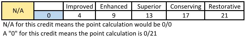
13 Natural World 1.6 Avoid Unsuitable Development on Steep Slopes N/A credit, verifier agreed No steep slopes on the site. The location is in the flat, coastal area with slopes from 1-2.5% on most of the property. The steeper slopes on the southwestern border are the banks of a creek and will not be disturbed during construction. Natural World 3.2 Control Invasive Species Sought the conserving level, verifier agreed Conserving: Invasive species control. The project team works with state and local agencies to identify current invasive species on the project site. The team establishes a comprehensive multiyear management plan to control invasive species. 13
14 DOES THE PROJECT MINIMIZE THE USE OF FOSSIL-FUEL BASED ENERGY? DOES THE PROJECT UTILIZE LOCAL MATERIALS? DOES THE PROJECT CONSIDER THE LIFE CYCLE OF THE MATERIALS USED, AND PLAN FOR THEIR END-OF-LIFE? HOW IS WASTE FROM THE PROJECT HANDLED? DOES THE PROJECT USE SUSTAINABLE MATERIALS, SUCH AS RECYCLED, REUSED, OR CERTIFIED MATERIALS? DOES THE PROJECT PROTECT FRESHWATER AVAILABILITY BY MINIMIZING ITS POTABLE WATER USE? Resource Allocation 1.4 Use Regional Materials Sought the conserving level, verifier agreed that we can achieve conserving level provided we note that concrete must come from within 100 miles Conserving: At least 95% locally sourced. At least 95% of all materials, plants, and soils are sourced within the distances specified: soils (50 mi, 80 km), aggregate (50 mi, 80 km), concrete (100 mi, 160 km), plants (250 mi, 400 km), and all other materials (500 mi, 800 km). 14
15 DOES THE PROJECT MINIMIZE GREENHOUSE GAS EMISSIONS? DOES THE PROJECT REDUCE AIR POLLUTANT EMISSIONS? DOES THE PROJECT MANAGE HEAT ISLANDS? DOES THE PROJECT PREPARE FOR SHORT-TERM HAZARDS? DOES THE PROJECT PREPARE FOR LONG-TERM ADAPTABILITY? 15

16 Resource Allocation 3.2 Reduce Potable Water Consumption 16
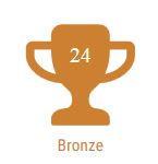
17 Verification Process Register the project, pay registration fee Verification fee, (varies based on the project size/cost) project is assigned a third-party verifier Conference call with POC at ISI, verifier, and project team involved with the envision submission Chat about project and background info to familiarize the group with the project before the verifier starts reviewing credits Verifier has a 90 day period to review credits and provide feedback and the initial verified score Re-Verification Process Verifier confirmed our score level of 24% We submitted for the Silver 35% Set up another conference call (with ISI POC and verifier) after reviewing verifier s comments to talk through the credits that we thought we may resubmit to gather any additional information that he may like to see for specific credits Evaluating the verifier s comments led us to go through the re-submittal process and we realized that the amount of credits we could resubmit could give us enough points to reach the Silver Level 17

18 Envision Flexibility QL2.5: Encourage Alternate Modes of Transportation 18

19 Lessons Learned Wide variety of infrastructure projects means a wide variety of documentation Qualitative credits were much easier to comply with Not all credits are applicable to all projects Find areas where your project excels Questions? 19
Envision Sustainable Infrastructure
 Envision Sustainable Infrastructure Marshview Park Allyson Monsour, PE, ENV SP, LEED Green Associate What Is Sustainability? Social Sustainability Fair and beneficial labor practices Community involvement
City of Langford Green Development Checklist
 City of Langford Green Development Checklist The following Green Development Checklist creates a sustainability standard for all comprehensive development within the City of Langford. The commitments made
This presentation has been developed by the Sustainable Sites Initiative for general audiences
 This presentation has been developed by the Sustainable Sites Initiative for general audiences Copyright 2011 by the Sustainable Sites Initiative. All rights reserved. 2011 2010 Sustainable Sites Initiative
Marshview Park. Concept Briefing and Feedback Session. Aquarium/Owls Creek Plan Steering Committee March 20, 2012
 Marshview Park Concept Briefing and Feedback Session Aquarium/Owls Creek Plan Steering Committee March 20, 2012 1 Outline of Today s Discussion Introductions Context for Marshview Park Site analysis -
10.0 Open Space and Public Realm
 10.0 Open Space and Public Realm 10.0 Open Space and Public Realm The Public Open Space System is comprised of: outdoor spaces available for public use that are either publicly owned (e.g., parks and
SECTION II SECTION II STATEMENT OF GOALS, OBJECTIVES, PRINCIPLES, ASSUMPTIONS, POLICIES AND STANDARDS
 STATEMENT OF GOALS, OBJECTIVES, PRINCIPLES, ASSUMPTIONS, POLICIES AND STANDARDS 1 2 STATEMENT OF GOALS, OBJECTIVES, PRINCIPLES, ASSUMPTIONS, POLICIES AND STANDARDS INTRODUCTION The New Jersey Municipal
Plano Tomorrow Vision and Policies
 Plano Tomorrow Vision and Policies PLANO TOMORROW PILLARS The Built Environment The Social Environment The Natural Environment The Economic Environment Land Use and Urban Design Transportation Housing
The Vision. Photo provided by The Minervini Group. 46 Vision, Objectives & Strategies
 Vision, Objectives & Strategies The is the public framework and guide for future development of the Grand Traverse Commons. The establishes public polices for infrastructure, the preservation of natural
Smart Growth Development Checklist
 2004 Smart Growth Development Checklist Smart Growth Development Checklist Corporation of the City of New Westminster Guide and manage growth in a manner which is consistent with the principles of sustainable
Errol Heights Park and Community Garden Frequently Asked Questions March 22, 2018
 Errol Heights Park and Community Garden Frequently Asked Questions March 22, 2018 Question 1: What improvements are planned for Errol Heights Park? How will the community be engaged in the process to shape
RECREATION, OPEN SPACE AND GREENWAYS ELEMENT GOALS, OBJECTIVES, AND POLICIES
 RECREATION, OPEN SPACE AND GREENWAYS ELEMENT GOALS, OBJECTIVES, AND POLICIES GOAL R-1: DEVELOP A RECREATION, OPEN SPACE AND GREENWAYS SYSTEM AS AN INTEGRAL COMPONENT OF AN OVERALL, COUNTY-WIDE ECONOMIC
Town of Peru Comprehensive Plan Executive Summary
 Town of Peru Comprehensive Plan Executive Communities that plan grow by choice, not by chance. A plan makes growth thoughtful, understandable, and predictable. A plan shows that a community is managing
Silverdale Regional Center
 Silverdale Regional Center Vision for Silverdale Regional Center The Silverdale Regional Center Plan (Plan) will guide the evolution of the Silverdale Regional Center from a collection of strip malls and
City of Los Angeles Department of Public Works
 City of Los Angeles Department of Public Works Environmental Scoping Meeting for the Proposed Sixth Street Park, Arts, River & Connectivity Improvements (PARC) Project May 3, 2017 1 Agenda Introductions
Planning for Sustainable Infrastructure: A Collaborative Integrated Approach. Background on Berkeley. Background on Paving Needs 8/30/2015
 Planning for Sustainable Infrastructure: A Collaborative Integrated Approach Andrew Clough, Ray Yep, Margo Schueler, Sean Rose Berkeley Public Works Commission, City of Berkeley, and AB Clough Consulting
What does LEED characterize?
 LEED Certification What does LEED characterize? Leadership in Energy and Environmental Development How was it created? Created by United States Green Building Council (USGBC) in 1998 Developed by architects
Complete Neighbourhood Guidelines Review Tool
 Complete Neighbourhood Guidelines Review Tool Prepared By: City of Regina Planning Department October 2014 Page 1 of 14 Community Development Review Checklist for Secondary Plans and Concept Plans The
Living in Albemarle County s Urban Places
 Living in Albemarle County s Urban Places ALBEMARLE COUNTY, VIRGINIA A Closer Look at Albemarle s Approach to Managing Growth and Creating Quality Urban Environments www.albemarle.org Page 2 Living in
March 21, 2018 ALCA Meeting. March 21, 2018
 March 21, 2018 ALCA Meeting March 21, 2018 Agenda 1. Process and Timeline 2. Original Submission 3. Revised Submission 4. Next Steps The City of Calgary Role: The City is responsible for capturing and
Central Lake Ontario Conservation Conservation Lands Master Plan
 Conservation Lands Master Plan Top 13 Frequently Asked Questions 1. What are conservation lands? Where are these conservation lands located in the Central Lake Ontario Conservation watershed? Conservation
Sustainable Road Design And Multimodal Roads. Presented by: Sheina Hughes
 Sustainable Road Design And Multimodal Roads Presented by: Sheina Hughes May 21, 2015 Roadways more than just mobility Perspectives from a former City Engineer LEED for Buildings made a Public Agency change
2035 General Plan Update and Belmont Village Specific Plan. Joint Study Session with the City Council and Planning Commission April 12, 2016
 2035 General Plan Update and Belmont Village Specific Plan Joint Study with the City Council and Planning Commission April 12, 2016 Agenda 1. Welcome and Introductions 2. General Plan Update Status of
RECREATION AND OPEN SPACE ELEMENT GOALS, OBJECTIVES, AND POLICIES
 RECREATION AND OPEN SPACE ELEMENT GOALS, OBJECTIVES, AND POLICIES Goal 7 To provide park facilities, recreation programs, and open space resources that are safe, adequate, and accessible to all City residents,
ARISE: The Rock Renaissance Area Redevelopment & Implementation Strategy
 2014 Professional Awards 1 ARISE: The Rock Renaissance Area Redevelopment & Implementation Strategy Janesville, WI Completed December 2014 Analysis & Planning Purpose of Project 2 The purpose of the Rock
Point Defiance Park. Master Plan Update. April 23 rd 2015
 Point Defiance Park Master Plan Update April 23 rd 2015 Public Participation 1/29, 2/26, 3/26 & 4/23 Tonight s Agenda: Introduction: March Meeting Recap: Overview Feedback Responses Presentation of Master
Kelowna Sustainability Checklist
 Kelowna Sustainability Checklist The City of Kelowna endeavours to Sustain the Environment. Encourage development and land use changes that will not compromise the ability of future generations to meet
Description of Preferred Alternative
 Chapter 2 Description of Preferred Alternative 2.1 Introduction This chapter of the programmatic Sammamish Town Center Sub-area Plan Final EIS provides a more detailed description of the Preferred Alternative
ROCHESTER INSTITUTE OF TECHNOLOGY Active Transportation Improvements 2010
 ROCHESTER INSTITUTE OF TECHNOLOGY Active Transportation Improvements 2010 In 2008, the Rochester Institute of Technology (RIT) completed a Comprehensive Parking and Transportation Study. Recommendations
OVERMOUNTAIN VICTORY TRAIL BURKE CALDELL CORRIDOR FEASIBLITY STUDY REQUEST FOR QUALIFICATIONS CALDWELL COUNTY PATHWAYS
 OVERMOUNTAIN VICTORY TRAIL BURKE CALDELL CORRIDOR FEASIBLITY STUDY REQUEST FOR QUALIFICATIONS CALDWELL COUNTY PATHWAYS Caldwell County Pathways along with our co-partners City of Lenoir, Town of Gamewell,
Introduction. Chapter 1. Purpose of the Comprehensive Plan Plan Organization Planning Process & Community Input 1-1
 Chapter 1 Introduction Lakewood 2025: Moving Forward Together Purpose of the Comprehensive Plan Plan Organization Planning Process & Community Input 1-1 Purpose of the Comprehensive Plan The Comprehensive
PARK AND RECREATION MASTER PLAN UPDATE
 PARK AND RECREATION MASTER PLAN UPDATE 2014-2018 Prepared for: Avon Parks, Recreation and Beautification Council (PRBC) and Town of Avon Prepared by: Lehman & Lehman, Inc. 24-Apr-14 Mission Statement The
APPENDIX A 6 CONCEPTUAL PRELIMINARY PLAN GUIDE AND CHECKLIST FOR MAJOR SUBDIVISIONS CARRBORO DEVELOPMENT GUIDE APPENDIX A
 6 CONCEPTUAL PRELIMINARY PLAN GUIDE AND CHECKLIST FOR MAJOR SUBDIVISIONS Conceptual Preliminary Guide/Checklist for Major Subdivisions Page 1 FORM: REVIEW DATE: CONCEPTUAL PLAN REVIEW 2000 REVIEWED BY:
BOROUGH OF HADDONFIELD GREEN DEVELOPMENT PRACTICES CHECKLIST November 15, 2013
 BOROUGH OF HADDONFIELD GREEN DEVELOPMENT PRACTICES CHECKLIST November 15, 2013 The following questions are intended to focus attention and elicit information on the use of various sustainable development
VCA Guidance Note. Contents
 Contents 1. Introduction... 2 2. Who can register a VCA?... 2 3. VCAs and sustainable development... 3 4. Verifying conservation performance... 4 4.1 Transparent, voluntary commitments... 4 4.2 Independent
EXECUTIVE SUMMARY DRAFT CHAPTER 1 INTRODUCTION EXECUTIVE SUMMARY
 CHAPTER 1 EXECUTIVE SUMMARY INTRODUCTION Through the joint efforts of the City of Tulsa planning staff and the Land Services division of Indian Nations Council of Governments (INCOG), the Berryhill Land
495/MetroWest Development Compact Plan Citizen Planner Training Collaborative Conference. March 17, 2012
 495/MetroWest Development Compact Plan Citizen Planner Training Collaborative Conference March 17, 2012 Project Process Local and Regional Priority Areas Growth Scenarios Transportation Investment Categories
Working Group Meeting
 April 4,, 2017 Parks Operations Bldg Working Group Meeting Arts Districts Overview Stormwater/RPA/Stream Considerations First Principles Agenda 7:00pm 7:05pm 7:10pm 7:40pm 8:30pm 9:40pm 9:45pm Welcome
LRPC VISION GOALS-OBJECTIVES-STRATEGIES
 ENVIRONMENT: Wooded surroundings, meandering creeks and natural beauty allow residents to enjoy the benefits of living in a low-density village setting with quick and easy access to the offerings of the
Dyersville Downtown Plan. Open House October 24, 2017
 Dyersville Downtown Plan Open House October 24, 2017 What is a Comprehensive Plan? - Vision - Guidance for decisions - Basis for regulations What is a Downtown Plan? - Understand priorities - Identify
PLANNING COMMISSION WORKSESSION AGENDA. City Hall Second Floor Conference Room 9027 Center Street. July 1, :30 PM
 MEMBERS Harry J. Clark, Chairperson Bruce Wood, Vice-Chairperson Russell Harrison Ken Johnson Robert W. Schilpp Martha Wilson PLANNING COMMISSION WORKSESSION AGENDA City Hall Second Floor Conference Room
June 12, 2012 Our File: O-20/02-II/I Doc#: I.VI. City Manager. General Manager Planning and Development
 CoQuitlam For Council Our File: 13-648O-20/02-II/I Doc#: 126318I.VI To: From: Subject: For: City Manager General Manager Planning and Development Partington Creek Neighbourhood Plan Update Council Recommendations:
This page intentionally blank.
 This page intentionally blank. Parks, Recreation, and Open Space Chapter Relationship to Vision Vision Parks, Recreation and Open Space Chapter Concepts County Government. County government that is accountable
Gold Line Bus Rapid Transit Transit Oriented Development (BRTOD) Helmo Station Area Plan
 Helmo Station Area Plan") Appendix F Gold Line Bus Rapid Transit Transit Oriented Development (BRTOD) Helmo Station Area Plan Introduction and Purpose of the Plan The Gold Line Bus Rapid Transit facility is an eleven-mile dedicated
Appendix F Gold Line Bus Rapid Transit Transit Oriented Development (BRTOD) Helmo Station Area Plan Introduction and Purpose of the Plan The Gold Line Bus Rapid Transit facility is an eleven-mile dedicated
10 Implementation. Implementation. Responsibility for Implementation. Blueprint for Bloomsburg. Town of Bloomsburg Comprehensive Plan 10-1
 Implementation 10 Implementation This chapter overviews how to use the comprehensive plan as a land use and programming tool for the Town of Bloomsburg and recommends annual review of the plan by the Town
WHITE FLINT SECTOR PLAN PHASE I PRESENTATION Montgomery County Planning Board April 13, Luxmanor Citizens Association
 WHITE FLINT SECTOR PLAN PHASE I PRESENTATION Montgomery County Planning Board April 13, 2009 Luxmanor Citizens Association An Inclusive Master Plan The Vision of a Better Community Pedestrian oriented
The Benefits and Challenges Associated with Green Infrastructure Practices
 The Benefits and Challenges Associated with Green Infrastructure Practices Thomas M. Evans ASLA, LEED AP Regional Green Infrastructure Design Services Director OWEA Technical Conference, June 20, 2013
Municipal Plan*Assessment
 Municipal Plan*Assessment This tool was developed to assist in reviewing municipal master plans and in determining if these plans are consistent with smart growth principles, neighboring municipal plans,
Draft Stillwater 2030 Comprehensive Plan- Goals and Policies
 Draft Stillwater 2030 Comprehensive Plan- Goals and Policies Instructions- Review each goal and policy and discuss with group any changes, deletions for additions to the list using your groups pen. Keep
CHAPTER 7: PARKS, OPEN SPACES AND RECREATION
 CHAPTER 7: PARKS, OPEN SPACES AND RECREATION The delivery of Parks and Recreation services in Port Moody aims to provide benefits, either direct or indirect, to all citizens in the community. There is
Community Information Meeting
 Queensborough Eastern Community Information Meeting July 24, 2014 Cameron Chalmers, MCIP, RPP Platform Properties Meeting Format Purpose Format The purpose of the meeting is to invite the community to
FOUR MILE RUN VALLEY WORKING GROUP AND CHARGE
 FOUR MILE RUN VALLEY WORKING GROUP AND CHARGE Adopted April 16, 2016 Amended July 19, 2016 Overview of Integrated Effort The overall goal of the Four Mile Run Valley (4MRV) initiative is to develop a comprehensive
5.13 RECREATION / OPEN SPACE
 5.13 RECREATION / OPEN SPACE The project includes the development of two 5+ acre public parks, four pocket parks and various trails. This complies with the Board of Supervisors established minimum standard
DRAFT MAP AMENDMENT FLU 04-4
 DRAFT MAP AMENDMENT FLU 04-4 SW 24 TH AVENUE ROADWAY CORRIDOR The University of Florida participates with the Metropolitan Transportation Planning Organization (MTPO) in its responsibilities for the continuing,
G. RECREATION AND OPEN SPACE ELEMENT. The following summarizes the Recreation and Open Space Element:
 G. RECREATION AND OPEN SPACE ELEMENT The purpose of the Element is to provide the framework and direction for a comprehensive system of public and private sites for recreation, including, but not limited
A BLUEPRINT FOR BROCKTON A CITY-WIDE COMPREHENSIVE PLAN
 A BLUEPRINT FOR BROCKTON A CITY-WIDE COMPREHENSIVE PLAN Public Meeting October 2016 1 Plan Summary and Discussion Public Meeting May 4 2017 City of Brockton Bill Carpenter, Mayor Department of Planning
Laberge Group. Town of Coeymans. Draft Comprehensive Plan. Overview of Planning Process
 Draft : Presentation of Goals & Strategies Laberge Group Benjamin H. Syden, A.I.C.P., E.D.P Director in Charge Nicole Allen, A.I.C.P. Senior Planner Anjali Malhotra Planner Presentation Outline Introductions
CHAPTER 7: Transportation, Mobility and Circulation
 AGLE AREA COMMUNITY Plan CHAPTER 7 CHAPTER 7: Transportation, Mobility and Circulation Transportation, Mobility and Circulation The purpose of the Transportation, Mobility and Circulation Chapter is to
RECREATION AND OPEN SPACE ELEMENT
 RECREATION AND OPEN SPACE ELEMENT Last amended August 19, 2008 Table of Contents Objective Page 5.1 Park system defined... 5-1 5.2 Access to parks and recreational facilities... 5-2 5.3 Recreation and
{Best Practices. Summary of Tools, Strategies and Best Practices from 11 Michigan Case Study Communities
 Case Studies Michigan Coastal Community Working Waterfronts { Summary of Tools, Strategies and from 11 Michigan Case Study Communities Table of Contents Zoning...2 Community and Stakeholder Collaboration
University of the District of Columbia Van Ness Campus Master Plan Community Open House 3. December 8, 2010
 University of the District of Columbia Van Ness Campus Master Plan Open House 3 December 8, 2010 Introductions Sequence of Work: Campus Master Plan BEGIN: INTRODUCE AND START WORK Project Initiation Team
13 Maintenance and Operations Plan 223
 222 13 Operations Maintenance and Plan 223 Chapter 13 MAINTENANCE AND OPERATIONS PLAN 13.1 Stewardship The Minneapolis Park and Recreation Board (MPRB) is the steward of a nationally-acclaimed park system.
implementation10 Village of Greendale Comprehensive Plan: Greendale, Wisconsin. Revisiting a Greenbelt Community
 implementation10 Village of Greendale Comprehensive Plan: 2010 - Village of Greendale Comprehensive Plan: 2010 - Implementation The recommendations of this Plan must be implemented by the Village of Greendale,
Keyport. Vision for Keyport
 Keyport Vision for Keyport Keyport is a rural, historic waterfront village bounded and limited in size by its natural borders of water and the Naval Undersea Warfare Center. The community consists primarily
Funding, Designing, and (eventually) Building Miles of Shoreline and Acres of Wetlands and Oyster Reefs on an Urbanized River!
 Building Miles of Shoreline and Acres of Wetlands and Oyster Reefs on an Urbanized River!") CW Gaskill City of Norfolk Funding, Designing, and (eventually) Building Miles of Shoreline and Acres of Wetlands and Oyster Reefs on an Urbanized River! Don Cole Brown and Caldwell C. W. Gaskill City
CW Gaskill City of Norfolk Funding, Designing, and (eventually) Building Miles of Shoreline and Acres of Wetlands and Oyster Reefs on an Urbanized River! Don Cole Brown and Caldwell C. W. Gaskill City
North Oakville East Parks Facilities Distribution Plan. November, 2009
 North Oakville East November, 2009 POLICY CONTEXT 1) Purpose a) The purpose of this document is to be a guide for the location, configuration, design and development of the parks system for the North Oakville
The Corporation of Delta. COUNC~L REPORT Regular Meeting. Burnsview Secondary School/Chalmers Park Memorandum of Understanding
 The Corporation of Delta COUNC~L REPORT Regular Meeting Fa 13 To: Mayor and Council File No.: 14035-20/ChaP From: Parks, Recreation & Culture Department Date: June 19, 2015 Burnsview Secondary School/Chalmers
2.1 Principles & Objectives
 Designing With The Landform 2.1 Principles & Objectives Land planning which integrates the natural features of a site (i.e., designing with the landform ) into the site design is a major component of the
Sustainably Repositioning Greyfield Sites. Greyfield Sites Anywhere
 Sustainably Repositioning Greyfield Sites Jim Constantine Looney Ricks Kiss Architects Todd Poole 4ward Planning Greyfield Sites Anywhere Pennsylvania Chapter American Planning Association Conference 2009
EXHIBIT. PUD Written Description
 EXHIBIT D PUD Written Description Krispy Kreme at Merrill Road PUD Revised 09-30-2013 City Development Number: I. PROJECT DESCRIPTION The subject property identified as Real Estate No.120466 0030 on Panel
Crofton Manor 2803 West 41st Avenue WHAT WE HEARD. Public Consultation: Phase 1
 Crofton Manor 2803 West 41st Avenue WHAT WE HEARD Public Consultation: Phase 1 Background CROFTON MANOR What s Happening The City of Vancouver is undertaking a planning and public engagement process to
TOWN COUNCIL / PLANNING COMMISSION
 Workshop #3 TOWN COUNCIL / PLANNING COMMISSION January 20, 2011 Consultant Team In Attendance Tonight BMS Design Group Nevada City and San Francisco Michael Smiley, AICP, ASLA Partner-in-Charge Nancy L.
1. Parks & Recreation Neighborhood Parks Community Parks Special Use Sites 2. Open Space 3. Trails
 Appendix A: Park Classifications The intent of parks and recreation classifications is to aid in making acquisition and design decisions for park sites, facilities and the organization of recreation space
TOD 101 CREATING LIVABLE COMMUNITIES WITH TRANSIT
 1 CREATING LIVABLE COMMUNITIES WITH TRANSIT What are transit Centered Communities? Benefits of Partnerships to Support and Implement What You Will Learn Portland s Pearl District Your Trainers Today Catherine
COASTAL CONSERVANCY. Staff Recommendation June 5, 2008 SAN DIEGO RIVER TRIBUTARY CANYONS PROJECT. File No Project Manager: Megan Johnson
 COASTAL CONSERVANCY Staff Recommendation June 5, 2008 SAN DIEGO RIVER TRIBUTARY CANYONS PROJECT File No. 08-059 Project Manager: Megan Johnson RECOMMENDED ACTION: Authorization to disburse an amount not
MONTHLY MEETING AGENDA
 Officers Jack Kooyoomjian, President Vice President - Vacant Kathleen Harding, Secretary Tom Burrell, Acting Treasurer Others Tom Burrell, PELT Committee Chairman Jan Cunard, LOCCA Historian MONTHLY MEETING
20 International Conference of The Coastal Society THE ROLE OF PLANNED UNIT DEVELOPMENTS IN ENVIRONMENTAL MANAGEMENT IN THE COASTAL ZONE
 th 20 International Conference of The Coastal Society THE ROLE OF PLANNED UNIT DEVELOPMENTS IN ENVIRONMENTAL MANAGEMENT IN THE COASTAL ZONE Kathleen E. Semon, University of South Carolina Braxton C. Davis,
ENVISION The Rating System for sustainable infrastructure in the USA
 ENVISION The Rating System for sustainable infrastructure in the USA CONTENTS 1. INTRODUCTION: APPROACH FRAMEWORK 2. ENVISION RATING SYSTEM FOR SUSTAINABLE INFRASTRUCTURE 3. DEVELOPMENT AND EVALUATION
City of Hermosa Beach Administrative Policy #
 City of Hermosa Beach Administrative Policy # SUBJECT: Living Streets Policy Date: Approved by: City Council Authority: Public Works Department & Community Development Department Mayor, PURPOSE The City
TOWN OF BETHLEHEM OPEN SPACE CONSERVATION PLAN PUBLIC MEETING: OCTOBER 12, 2017
 TOWN OF BETHLEHEM OPEN SPACE CONSERVATION PLAN PUBLIC MEETING: OCTOBER 12, 2017 Welcome and Agenda 6:00 6:45: Open House, Part One 6:45 7:15: Presentation and Questions 7:15 8:00: Open House, Part Two
Vancouver. Title of the Initiative. Initiative Duration. Submitted by. Comments by the Jury
 134 Vancouver Title of the Initiative Initiative Duration Submitted by Comments by the Jury Visionary Vancouver: Creating a Welcoming and Sustainable Place for All 2009-2020 Wendy Au, Deputy City Manager,
DRAFT PLAN PRESENTATION
 DRAFT PLAN PRESENTATION 1.23.2018 AGENDA Process Project Schedule Results from Visioning Workshop Draft Plan Highlights Concept Plans Feedback Next Steps PROJECT SCHEDULE KICK-OFF WORKSHOP August 29 th
CHAPTER 1: INTRODUCTION
 CHAPTER 1: INTRODUCTION MAP OF OUTAGAMIE COUNTY, WI N 1 = 6 miles INTRODUCTION The Town and Village of Black Creek are located in central Outagamie County, Wisconsin. The Village is located in the north
Arkansas River Corridor
 Planning for Access Welcome to the Access Project. This project is a recreational planning effort in response to an interest by regional communities along the Arkansas River corridor. The project plan
REGIONAL ACTIVITY CENTER
 DRAFT REGIONAL ACTIVITY CENTER 70 EAST BENCH MASTER PLAN DRAFT 06 Introduction The East Bench Regional Activity center is comprised of large educational, research, medical, and employment centers. These
Small Area Plan. South Gateway
 Small Area Plan Adopted May 12, 2008 South Gateway Purpose. The South Gateway Small Area Plan defines the City s expectations for the future of the southern entrance to the City at Interstate 85 and Highway
3.1 community vision. 3.3 required plan elements
 Chapter 3 Community Form 3.1 community vision 3.2 Parks & landscaping concepts 3.3 required plan elements D R A F T 20 Community Form Chapter 3 3.0 Community form 3.1 community vision The Specific Plan
Transportation. Strategies for Action
 Transportation A major priority for the Overlake Neighborhood is to develop a multimodal transportation system. To achieve this system, a balance has to be found among travel, circulation and access needs;
BROOKHILL NEIGHBORHOOD MODEL ZONING MAP AMENDMENT PREFACE TO APPLICATION
 BROOKHILL NEIGHBORHOOD MODEL ZONING MAP AMENDMENT PREFACE TO APPLICATION June 15, 2015 Revised: August 1, 2016 I. VISION Brookhill is a proposed community based upon the principles of Albemarle County
One said, without a clear understanding of what will be annexed, this is an exercise in futility.
 Stakeholder Focus Groups: Summary of Meetings Stakeholder Focus Group meetings were held on at the Pinellas County Planning Department conference room. Focus Group meetings will be held during each of
Waverley West B Secondary Planning Process. Open House South Pointe School April 25, 2018
 averley est B Secondary Planning Process South Pointe School April 25, 2018 averley est B Secondary planning process open house Please review the boards and provide your feedback. 1 The Role of a Secondary
APPENDIX F: EXTERNAL APPROVALS
 1.0 RESPONSIBILITIES When the City is constructing the Park or Open Space Development lands (OPTION I), after the subdivision construction process is completed by the Developer, Open Space Development
Support the implementation of Cape Coral's Comprehensive Plan. Protect and utilize the unique natural resources in the City.
 7.0 OVERVIEW - RECOMMENDATIONS Chapter 7 The preparation of the Cape Coral Parks and Recreation Master Plan spanned a period of approximately 12 months. Plan preparation included the input of a wide range
IV. Development in the Rural Overlay District
 Intracoastal Waterway Route 17 Route 168 Great Dismal Swamp VIRGINIA NORTH CAROLINA IV. Development in the Rural Overlay District IV-1 Route 17 in Chesapeake s Rural Overlay District affords distant views
April 11, 2016 Park Board Chair and Commissioners General Manager Vancouver Board of Parks and Recreation New Brighton Salt Marsh - Preferred Concept
 TO: FROM: SUBJECT: April 11, 2016 Park Board Chair and Commissioners General Manager Vancouver Board of Parks and Recreation New Brighton Salt Marsh - Preferred Concept RECOMMENDATION A. THAT the Vancouver
Ten Mile Creek Planning Area
 PLANNING AREA POLICIES TEN MILE CREEK Ten Mile Creek Planning Area Location and Context The Ten Mile Creek Planning Area ( Ten Mile Creek area ) is located south of the current Boise AOCI, generally south
City of Redmond. Urban Holding Area Master Planning Requirements and Approval Process
 City of Redmond Urban Holding Area Master Planning Requirements and Approval Process June 21, 2006 City of Redmond: Urban Holding Area Master Planning Requirements and Approval Process Table of Contents
implementation r expression in landscape
 6 ubc okanagan implementation campus plan r expression in landscape 68 6 implementation campus plan sections The Campus Plan supports the academic mission, values and commitments of the University by providing
Neighborhood Infrastructures Blue Green Infrastructure
 Neighborhood Infrastructures Blue Green Infrastructure Blue green infrastructure refers to the components of the neighborhood fabric that connect habitat, parks and open space while managing stormwater.
Subregion 4 Central Avenue-Metro Blue Line Corridor Transit-Oriented Development (TOD) Implementation Project. Community Meeting April 27, 2011
 Implementation Project. Community Meeting April 27, 2011") Subregion 4 Central Avenue-Metro Blue Line Corridor Transit-Oriented Development (TOD) Implementation Project Community Meeting April 27, 2011 Overview Introduction to Subregion 4 TOD Implementation Program
Subregion 4 Central Avenue-Metro Blue Line Corridor Transit-Oriented Development (TOD) Implementation Project Community Meeting April 27, 2011 Overview Introduction to Subregion 4 TOD Implementation Program
Weston s Wetlands, Stormwater, & Open Space
 Weston s Wetlands, Stormwater, & Open Space Weston s Wetlands, Stormwater, & Open Space Conservation Commission Role and Responsibilities Laws that protect wetlands What residents can do to protect wetlands