l i v i n g a m i d s t m e a d o w s - m a s t e r p l a n n i e u w v e e n s e l a n d e n
|
|
|
- August Hampton
- 5 years ago
- Views:
Transcription
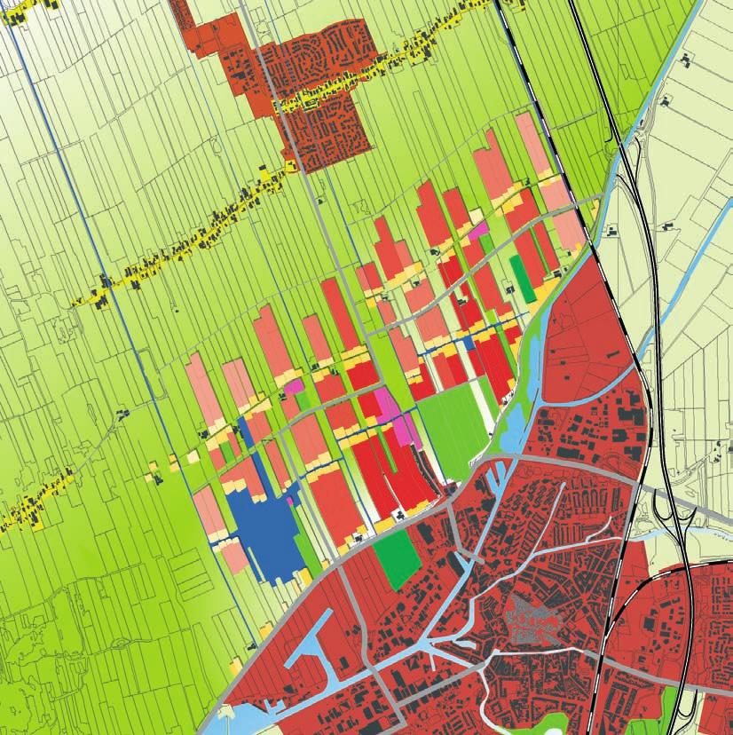
1 living amidst meadows - master plan nieuwveense landen l i v i n g a m i d s t m e a d o w s - m a s t e r p l a n n i e u w v e e n s e l a n d e n
2 City of Meppel project manager Ina Eleveld Postbus 501, 7940 AM Meppel The Netherlands e. OKRA landschapsarchitecten bv wonder city+landscape Oudegracht 23, 3511 AB Utrecht 7 Payne Street, Eumundi, 4562 QLD The Netherlands Australia t. +31 (0) t. +61 (0) e. mail@okra.nl e. info@wonder-cl.com master plan Nieuwveense Landen - june 2005 OKRA landschapsarchitecten bv, Utrecht. 2
3 inhoud 1. SUMMARY 2. GUIDELINES foundation of the plan guidelines flexibility is necessary 3
4
5 1. SUMMARY
6 Summary of the master plan For Meppel, the development of the Nieuwveense Landen, a new residential area with 5300 units, means an increasing of its size by a third: an enormous task. What s more, the municipality does not simply want to have a new residential area the area must also be integrated as a typical part of Meppel and function as a link between the city and the countryside. And all this together will be built in a time frame of 25 years. The process through which Nieuwveense Landen is to become a typical part of Meppel is threefold: The urban development concept is based on the location s specific situation with regard to soil and water, and the peat meadow landscape to which these have given rise, with its open grassland, upward stretching parcels and ribbon development. The development programme is placed and combined in such a manner as to enable the area to have meaning for Meppel as a whole. And the new district will be an extension of the city s cultural identity. The landscape s soil and water provided the basis for its development through the centuries. The landscape s numerous ditches are a clear sign of damp, peaty subsoil; the residential project will not be built using hydraulic filling, but actually built on this subsoil. All of the ditches present in the landscape are to be preserved. They form the basis of the landscape s water system, which will be converted from an agricultural to a more natural regime. The ditches shall also serve as the basis for the project s urban development pattern. Providing both perspective and rhythm, they are an essential feature of both the old landscape and the new residential area to come. A portion of the parcels between the ditches is to be developed. The differences in parcel width result in a continuous variety of subdivisions and a different kind of development for each strip. The strips alternate with open grassland zones, which extend deep into the residential area, so that each home is the same small distance from a stretch of grassland. And these grassland zones, which form a transition to the magnificence of the peat moor landscape outside the residential area, will continue to be used for agriculture. Three ribbons intersect the arrangement of development strips and grassland zones. Each ribbon has its own character: a street ribbon, a water ribbon and a work ribbon. The ribbons are developed from three existing lines in the landscape. With this harmony of the strips, ribbons and grassland zones, the residential area will be carrying forward on the specific landscape of this location. For the Nieuwveense Landen to become really a part of Meppel, residents from other areas will need to have a reason to go to the new residential district. This is why sports fields, a park and cultural facilities are to be combined here into a municipal park. And, through the addition of a water sports recreation facility, the sand-extraction lake will be expanded into an item of importance for the entire city. Together they will ensure that the new residential area will form an integral part of Meppel s network of urban facilities. At the same time, the Nieuwveense Landen will be given a finely meshed network of paths for cycling and walking, with numerous connections to the city and the surroundings areas. This will improve the outflow opportunities from present-day Meppel to such recreationally important areas as De Wieden and the Holterberg. And through the resulting intertwining of residential area and landscape, one will be able to begin a recreational walk long before reaching the city limits. A vital and active city, Meppel has always combined industry with commerce, and Nieuwveense Landen is in keeping with this tradition. Culture-historical elements of the peat extraction process that can be found here, e.g., canals, quays and locks, will be given a new lease of life as part of the master plan. Vitality will be attained by means of a strong centre and integration of commercial and agricultural activities, catering trades, schools and care facilities into the ribbons. Of special importance in connection with Nieuwveense Landen is the aspect of gradual growth over a period of 25 years. The urban development system of ribbons and development strips and pre-plantation along the ditches, lends itself excellently to a gradual populating of the landscape, with perpetually green borders and unobstructed views of the grasslands. 6
7
8
9 2. GUIDELINES


10 FOUNDATION OF THE MATER PLAN The landscapes around Meppel are of great national, partly even European importance. The city of Meppel is going to grow in one of these landscapes. The council of Meppel acknowledges the importance of this landscape. She has required a master plan for a new housing area that shows great respect for this landscape. It became a plan that is not consuming landscape, overruling it by a new city pattern and shutting the landscape out, but a plan that integrates the two, makes a symbiosis between city and landscape. Motto: living amidst meadows The new housing area is going to be a landscape-city. City and landscape are interweaved in the new city district. The meadows and building sites are combined like the fingers of two hands shoved into each other. 10

, quays, locks and sailable water.")
11 Typical Meppel-like The new housing area also has to become typical for Meppel. Six ingredients are used in the design to achieve that. The ingredients spring from the here existing landscape and the city of Meppel, including their cultural history. Ingredients from the landscape: - the stretched out parceling of the meadows and ditches is the base for the new urban pattern; - an occupation pattern of ribbon-development, characteristic for this landscape, refines the new urban pattern; - integrating historical elements of the peat production: griften (small canals used for peat boats), quays, locks and sailable water. Ingredients from the city: - two urban facilities of importance for the whole city are added to the district (city park and recreation lake); - recreational linking of city and landscape through a finely meshed network of paths; - Meppel is a working city. The new city district has to be more than just housing and therefore contains all kinds of possibilities for working (at home, services, businesses, city-related farms, et cetera). The pattern of city and landscape interlinking and these six ingredients together form the basic philosophy of the plan. They are the ultimate touchstone for all further working out of the plan. 11
12 GUIDELINES In the master plan for Nieuwveense Landen these main ideas are worked out in all kinds of themes and guidelines. Some of them have taken a lot of research and negotiations to reach the outcome that s in the master plan. For example: the exact pattern of meadows and building sites, the position of the main road, the level sectors of ground water, the position of the shopping center. These can all be found in the map of the design and are further explained in the theme maps. There are those that are used as a technical starting-point to be able to make the plan, but need to become clearer during the process. For example: the housing program and the exact working of the water system. A third category is formed by those put in to guarantee the spatial quality of the plan when worked out. For example: the spatial rules for the meadowzones, the building strips, the ribbon-parcels and for growing. These guidelines are presented in the master plan by little icon-like drawings. In principal all these guidelines can be changed. How strict the guidelines are interpreted depends on the political decisions that are made and the phase of plan-developing that is at hand. In the following pages the main guidelines are presented, including the considerations. 12
13 WATER SYSTEM Guidelines * All ditches are maintained. * Agricultural water system (high summer level, low winter level) to a more natural water system (one level with light natural fluctuations). Considerations The water system has both a technical and environmental goal as a strategic goal in developing a new housing area. Technical / environmental is to keep all rain water in the area and improve the water quality. For this the plan needs: - a large amount of water surface, well spread through the whole district, - lots of edges (purifying vegetation), - limited distances between road and roof surfaces and open water, - and visual connection between rainwater of roofs and streets and the open water. The last is to make the inhabitants environmental aware through showing the direct relation between water-polluting activities and the surface water. These technical and environmental goals are best served by maintaining all ditches. The strategic importance of keeping all ditches is to force developers (governmental and private) to make every building strip different from the next one. Doing so keeps the under layer of the landscape recognizable in the housing area (ditches, views over the ditches, stretched out characteristic). And it gives variety to the housing area itself, makes orientation easier and gives a base for developing a neighborhood feeling. A weakness in strictly maintaining all ditches is that the ditches are to small to be used by boats, even canoes and rowing boats. Combining a few ditches to a broader channel would solve this, but might give other limitations again. 13


14 MEADOW ZONES Guidelines * The meadow zones stretch out into the open landscape to the north of the development. There are no visual barriers blocking the vistas. * The meadow zones have a minimum broadness of 40 meters, half a minute walking. * The distance between two meadow zones is a maximum of 250 meters. Every house is close to a meadow zone. Walking a block one always comes along a meadow and has a view to the open landscape. * The meadows provide the experience of space in the city district. Therefore the vegetation is low, mainly grass. * There is a gradient in soil and vegetation of the meadows from west to east: - more wet and peat-like in the west, with possibilities for developing swamplike meadow vegetation with edges of shrubbery in connection with the Wieden; - the middle and north part are open meadows with edges of alder, connecting to the open peat meadow landscape; - the dryer and bit more sandy east gives possibilities for grassland, open air horticulture and vegetable gardens with larger trees like oak on the sides. 14


15 Considerations The multiple meadow zones give the district a unique identity, different from all other areas in Meppel or even in the rest of the Netherlands. It integrates the spaciousness of a typical Dutch landscape in a housing development. Because of the density of the meadow zones everybody in the area lives close to a meadow zone, thus realizing the motto living amidst the meadows. The pattern and exact position of the meadow zones and building strips in the master plan is a result of: - vistas to important points in the landscape and city; - a financial optimum for the plan; - visual and experience studies resulting in the guidelines for measurements. Crossing a meadow zone you have to be able to see the open landscape outside the district to make the connection between neighborhood, meadow zone and open landscape reality. Therefore the guideline concerning low vegetation is introduced. Though when the meadow vegetation in the whole district would be the same, the area becomes to uniform. On the other hand, the soil and water circumstances are not in all meadow zones the same. The district is given variety and different atmospheres through changing the vegetation and use of the meadow zones from east to west. The guidelines about size and position of the meadow zones are already integrated in the layout of the urban pattern. The guidelines about the use and vegetation (keeping the views and giving different atmospheres to different parts of the district) are important for the further work out of the plan. 15


16 BUILDING STRIPS Guidelines * Maintaining all ditched. Two ditches with green slopes border every building strip. Every strip has its one unique width. * Every border between a strip and meadow zone is a front side, with addresses and a public road. The borders are planted with trees, making a green background to the open meadow space and keeping the view through a green curtain from the building side. * All building strips are oriented to the sides. The strips have the same profile over the whole length. * Every strip is a strong visual unity. Each one is clearly different from the next one. Considerations The guidelines make characteristics of the landscape underneath still readable in the city district and the built neighborhoods: the strong linearity north - south combined with a refined rhythm of parcels east - west. The front sides to the meadow zones are a guideline to make sure the meadow zones can be experienced by every inhabitant, not only the ones who live on the sides of the meadows. A justly question is if it s necessary to make every meter of the meadow sides a front side. Probably not, though this is the easiest way to guarantee that every inhabitant can enjoy the presence of the meadows the most. In the case the edge is not public, the accessibility of the meadows should be guaranteed in other ways. The meadows loose value when less people can enjoy them. 16


17 RIBBON PARCELS Guidelines * All building lots along the ribbons have the building characteristics of a farmyard, with a main building in the front, asymmetrical on the lot, and additional buildings in the back. * Between every two parcels in the ribbon there is a free view over the ditch to the land behind. * Every parcel is oriented to the road, with a representative front. The sides and the back are planted. Considerations The guidelines are there to create the characteristics of a historical ribbon development. They help to make the district typical for Meppel and for this landscape. The ribbons should be recognizable different from the building strips. Therefore the guidelines of the strips and ribbons are made different. The clearly recognizable ribbons together with a different basic design per the ribbon (street, water, on sided), give a condition for orientation in the district in the north - south direction. * Every lot along the ribbon is different from the next one, with a changing building-line, building volume, architectural style and from different times 17
.")

18 TRAFFIC SYSTEM Guidelines * The main road is positioned within the district and not on the edge. * A finely meshed network of paths, following the grid structure of meadow zones and ribbon developments, makes the district very accessible for low speed traffic (bicycle, pedestrian, et cetera). These paths connect to the city and into the landscape. Considerations Two reasons to position the road in the middle of the housing area: - to keep the contact with the surrounding landscape; the road shouldn t become a border; - a more efficient road system. Houses are built on both sides of the main road. This gives more connections to the neighborhoods. Each connection gets less traffic, which gives better living conditions for the houses around the connection roads. Slow traffic (pedestrians, bicycles, etc.) should be a good alternative for the car, to move around in the district and to go to the rest of Meppel. For this the network of paths has to be: - very direct, making short connections while the car has to take a detour - comfortable and safe to ride and walk on. Furthermore a finely meshed network with lots of connections to outside is the best way to physically make Nieuwveense Landen a link between city and landscape. 18
19 URBAN FACILITIES Guidelines * The sand extraction lake will be transformed to a recreational lake with nature and housing at its borders. * A new city park will be developed at the connection point of existing city and new district. It will become an active park with all kinds of facilities, like sport fields and cultural facilities. * The district center is placed in the middle of the district, good accessible by car and by bicycle. * The sailable water ribbon connects park, lake and center. Together they form a recreational backbone in the plan. Considerations The sand extraction lake is part of the plan area. Better to make something positive out of it. Being close to the Wieden it can be buffer for recreation. Better to keep most of the recreation of the district and city within the area than to let it spread out to this natural reserve of European importance. The city has no good accessible lake for day recreation at this moment. Therefore the lake will be valuable for all residence of Meppel. The surrounding of the lake also can have some of the natural value of the Wieden, so people can see and experience it here, creating less recreational pressure on the Wieden. The park is programmed this way and places at the connection point of city and new development to attract people of both areas to recreate and meet here. The park has two vistas to the landscape so every visitor will immediately will experience the atmosphere and identity of the district as housing amidst meadows. The guidelines for urban facilities are mainly about their position in the district and give a rough layout of their program. Further guidelines for working out the design still have to be made. 19


20 GROWING DEVELOPMENT Guidelines * Starting to build from the middle, where the connection to the rest of Meppel is. * The transition of district to landscape is gradual in every phase of the development. * The edges of the district are always green, through planting prior to building * The ribbons grow through progressive increasing the density * Strips grow more in units enclosed by the meadow zones and ribbons Considerations When the housing market decreases, the city must be able to stop or slow down the development without being left with a clearly not finished area or a non-functional district because parts are missing. The housing area always has to be connected to the existing city, not being an island in the countryside. Also the border between city and landscape should look finished at every moment of construction. Meppel is going to grow into a very open and therefore vulnerable landscape. Construction sites will be visible from long distances. Normally the neighborhood edges will only be planted after construction has finished. And then the trees still need years to grow before the bare walls of housing will be covered and the landscape has its green appearance again. To show respect to the landscape implies to prevent these open wounds. Pre-planting the outlines of the meadow zones is the best way to do this. A district that has a sense of time built in, like historical cities, becomes livelier in its appearance. Nieuwveense Landen is going to be built in 25 years. This gives the unique opportunity to spatially mix the building periods, thus creating a sense of history that doesn t exist in an average new housing district. However mixing building periods had the disadvantage that the building process can be a burden to more residents over a longer period of time. 20

21 FLEXIBILITY IS NECESSARY During the process of further developing the district and working out all kinds of aspects, the guidelines as mentioned above can also start to restrain creativity. However, a certain restriction is necessary to get away from standard solutions practiced everywhere in the country and move towards more creative solutions, designed specific for this district of Meppel. On the other hand, the plan has to be able to adapt to the changing demands of society in the next 25 years. Therefore the total of guidelines can never be taken as a 100% rule. The challenge for this phase of the plan is to find out how many of the guidelines have to be kept and how many can be bent without loosing the quality of the plan. Per neighborhood the specific combination of guidelines and flexibility within can be different. But the goals and considerations behind the guidelines stay valid. In that way they are more essential than the guidelines themselves. And most important of all is that the main pattern of open fields and building sides and the six ingredients of the plan are realized. 21

22
MEETING PURPOSE AND OVERVIEW
 MEETING PURPOSE AND OVERVIEW On February 23, 2012, the City of Elk Grove hosted the first of two community workshops related to the Southeast Policy Area. The workshop was held from 6:00 8:30 p.m. in the
Good education Good living Green future
 D66 Groningen - english summary of the election programme - 2018-2022 Good education Good living Green future Together we make Groningen Highlights 2 Groningen has many things to offer: a vibrant cultural
Elliot Park 2. Neighborhood Master Plan. Historical Perspective
 Elliot Park 2 Neighborhood Master Plan Historical Perspective August 2002 Early History Development patterns and the growth of Minneapolis largely grew out of the city s historical response to its geography.
CITY CLERK. Parkland Acquisition Strategic Directions Report (All Wards)
") CITY CLERK Clause embodied in Report No. 10 of the, as adopted by the Council of the City of Toronto at its meeting held on November 6, 7 and 8, 2001. 10 Parkland Acquisition Strategic Directions Report
CITY CLERK Clause embodied in Report No. 10 of the, as adopted by the Council of the City of Toronto at its meeting held on November 6, 7 and 8, 2001. 10 Parkland Acquisition Strategic Directions Report
Section 1 Introduction
 Section 1 Section 1,, describes the role of the Official Plan. The Official Plan is one of five growth management plans that was completed under the umbrella of Ottawa 20/20. 1.1 The Role of the Official
The Hague: pedestrians in residential areas
 The Hague: pedestrians in residential areas Ir. Enno B. Ebels Department of Urban Planning City of The Hague Postbus 12655 2500 DP Den Haag the Netherlands enno.ebels@denhaag.nl Abstract The city of The
SPG 1. * the northern and western sections which are open fields used for pasture and grazing;
 SPG 1 1.0 INTRODUCTION This development brief is based on the allocation of the Priors Hall site for employment and countryside recreational purposes in the Corby Borough Local Plan. The brief is intended
Access Management: An Overview
 Figures 1-5 Below Evolution of development along a highway. In the early stages, land along the road is used for farming with little traffic generated. As time passes, the highway corridor becomes a de
10.0 Open Space and Public Realm
 10.0 Open Space and Public Realm 10.0 Open Space and Public Realm The Public Open Space System is comprised of: outdoor spaces available for public use that are either publicly owned (e.g., parks and
12.2 CONCEPT DEVELOPMENT
 12 12.0 Final Concept Plan & Development Scenarios 12-1 12.1. Introduction 12-1 12.2. Concept Development 12-1 12.3. Concept Evaluation 12-2 12.4. Development Scenarios 12-2 12.1 INTRODUCTION Though the
The Dreispitz in Basel / Switzerland: New economy on old sites
 The Dreispitz in Basel / Switzerland: New economy on old sites 1. Introduction At 50.000m 2 Dreispitz is currently the largest and most ambitious development project in Basel, the second biggest town in
Final Master Plan and Development Control Regulations
 1. INTRODUCTION CHECK LIST a. Introduction b. Table of contents c. Definitions. d. scope of works. 2. FINAL OVERALL MASTER PLAN a. SITE ANALYSIS and OVERVIEW: i. Existing and Proposed Site Plan Levels.
Appendix C: Interim Mixed-Use Evaluation Criteria
 Appendix C: Interim Mixed-Use Evaluation Criteria C-1 Appendix C: Interim Mixed-Use Evaluation Criteria PURPOSE: The implementation of numerous policies contained within the Master Plan hinges on the creation
2. Form and Character. 2.1 Introduction. 2.2 The Downtown Addition Plan. 2.1 Introduction
 2.1 Introduction 2.1 Introduction This section of the Specific Plan describes and illustrates the desired form, character and uses of the Downtown Addition and explains the underlying design principles.
Glenborough at Easton Land Use Master Plan
 Land Use Framework November 30, 2007 2.0 LAND USE FRAME- WORK 2.1 LAND USE HISTORY and Setting Glenborough at Easton is located on property that was used for mining in the 19th and 20th centuries and rocket
CHAPTER 7: VISION AND ACTION STATEMENTS. Noble 2025 Vision Statement
 CHAPTER 7: VISION AND ACTION STATEMENTS This chapter presents the vision, policy and action statements that transform the comprehensive planning study, an analysis of Noble s past, future trends and community
4-Town Comprehensive Plan DRAFT 7/30/07
 4-Town Comprehensive Plan DRAFT 7/30/07 Acknowledgements ning Committee Town of Harrisburg Norman Roof Randy Nicol Town of Martinsburg Terry Thisse Paul Kelly Town of Montague Jan Bagdanowicz Wendy Perry
3. VISION AND GOALS. Vision Statement. Goals, Objectives and Policies
 Vision Statement Queen Creek s interconnected network of parks, trails, open spaces and recreation opportunities provide safe and diverse activities and programs that sustain its unique, small town, equestrian
MARINA MARKET & WATERFRONT DEVELOPMENT STUDY PORT ARANSAS, TEXAS
 MARINA MARKET & WATERFRONT DEVELOPMENT STUDY PORT ARANSAS, TEXAS FEBRUARY 2015 PRESENTATION OUTLINE 1 2 3 4 5 6 7 REGIONAL POSITIONING SITE IMPRESSIONS PLANNING & DESIGN PRINCIPLES EXISTING IMPROVEMENTS
GREEN NETWORK APPLICATIONS IN ESTONIA
 GREEN NETWORK APPLICATIONS IN ESTONIA Kalev Sepp, Tuuli Veersalu, Martk Külvik Estonian University of Life Sciences 1 WHY? BACKGROUND - POLITICAL By adopting the Pan-European Biological and Landscape Diversity
ACUPUNCTURAL ARCHITECTURE IN BURAIL
 ACUPUNCTURAL ARCHITECTURE IN BURAIL ADDITIONAL BOOKLET 2013 / 2014 Naisa Al Kailany, Mania Bien, Floor Brinks, Hans Kalkhoven REFLECTION GENERAL INFORMATION BURAIL Area of the Plot Permanent cluster 400
REGION CITY ASSESSMENT OF THE STRENGTHS AND WEAKNESSES IN THE OTHER THREE PROJECTS
 REGION CITY ASSESSMENT OF THE STRENGTHS AND WEAKNESSES IN THE OTHER THREE PROJECTS 1 REIULF RAMSTAD SIGHT LINES AND DIRECTIONS IN THE PLAN To integrate an entirely new neighborhood in an existing urban
REDMOND CENTRAL CONNECTOR ART & DESIGN MASTER PLAN
 REDMOND CENTRAL CONNECTOR ART & DESIGN MASTER PLAN Redmond Central Connector Master Plan design principles principles make it redmond: past, present, future not just a place with art, a place that is art
Complete Neighbourhood Guidelines Review Tool
 Complete Neighbourhood Guidelines Review Tool Prepared By: City of Regina Planning Department October 2014 Page 1 of 14 Community Development Review Checklist for Secondary Plans and Concept Plans The
River Kleine Nete : Creating ecological flooding zones at recreation areas
 Stoffel Moeskops Lange Kievitstraat 111-113 bus 64 B-2018 ANTWERPEN T +32 3 205 81 25 s.moeskops@vmm.be River Kleine Nete : Creating ecological flooding zones at recreation areas \\\\\\\\\\\\\\\\\\\\\\\\\\\\\\\\\\\\\\\\\\\\\\\\\\\\\\\\\\\\\\\\\\\\\\\\\\\\\\\\\\\\\\\\\\\\\\\\\\\\\\\
Gold Line Bus Rapid Transit Transit Oriented Development (BRTOD) Helmo Station Area Plan
 Helmo Station Area Plan") Appendix F Gold Line Bus Rapid Transit Transit Oriented Development (BRTOD) Helmo Station Area Plan Introduction and Purpose of the Plan The Gold Line Bus Rapid Transit facility is an eleven-mile dedicated
Appendix F Gold Line Bus Rapid Transit Transit Oriented Development (BRTOD) Helmo Station Area Plan Introduction and Purpose of the Plan The Gold Line Bus Rapid Transit facility is an eleven-mile dedicated
CHAPTER 5: GUIDING PRINCIPLES
 CHAPTER 5: GUIDING PRINCIPLES The following 10 principles were developed based on public consultation, planning policy and the background analysis conducted during Phase 1. The Guiding Principles significantly
SQUAMISH 2010 AND BEYOND COMMUNITY VISION
 Our plan has been imagined and created to be both pragmatic and visionary. At the core of the strategy is a consideration of the highway s role and its impact on the community. First and foremost in creating
DRAFT Amsterdam/Churchill Community Plan (4/17/08) Adopted By the Gallatin County Commission
 Adopted By the Gallatin County Commission") DRAFT Amsterdam/Churchill Community Plan (4/17/08) Adopted By the Gallatin County Commission Table of Contents Acknowledgements Chapter 1: Introduction A Brief History What s Next Authority Organization
DRAFT Amsterdam/Churchill Community Plan (4/17/08) Adopted By the Gallatin County Commission Table of Contents Acknowledgements Chapter 1: Introduction A Brief History What s Next Authority Organization
Toronto Complete Streets Guidelines
 Toronto Complete Streets Guidelines 108 110 7.1 Green Infrastructure Design Principles 112 7.2 Context-Sensitive Green Streets 114 7.3 Key Green Street Elements Green infrastructure refers to natural and
Scope of Services. River Oaks Boulevard (SH 183) Corridor Master Plan
 Corridor Master Plan") Scope of Services River Oaks Boulevard (SH 183) Corridor Master Plan PROJECT AREA The project area consists of the River Oaks Boulevard (SH 183) corridor bounded by SH 199 at the northern end and the Trinity
Scope of Services River Oaks Boulevard (SH 183) Corridor Master Plan PROJECT AREA The project area consists of the River Oaks Boulevard (SH 183) corridor bounded by SH 199 at the northern end and the Trinity
Urban planning and Public Transport
 Urban planning and Public Transport MOJCA SASEK DIVJAK Urban Planning Institute of the Republic of Slovenia Trnovski pristan 2, 1000 Ljubljana SLOVENIA e-mail: mojca.sasek@uirs.si; http://www.uirs.si Abstract:
PLAN ON A PAGE SUMMARY
 Questions? Please Call - 423-989-5518. PLAN ON A PAGE SUMMARY The Plan on a Page is a tool for the City of Bristol to engage Bristol s neighborhoods, community organizations, and interest groups to organize
Physical Structure. This historic image from 1882 emphasizes the dramatic topography that distinguishes Cornell s setting at the top of East Hill.
 Physical Structure The natural, agrarian and urban setting for Cornell s campus is a precious resource to protect and enhance. It has also shaped the physical structure of the campus. Buildings, roads
SOCIO-ECONOMIC MOVEMENT ENVIRONMENT INFRASTRUCTURE TOWN PLANNING
 Table 7: SWOT Analysis SWOT ANALYSIS SOCIO-ECONOMIC MOVEMENT ENVIRONMENT INFRASTRUCTURE TOWN PLANNING STRENGTHS HIGH COMMUTER POPULATION DENSITY MAJORITY OF POPULATION BETWEEN AGE OF 15 & 34 LARGE AVAILABLE
URBAN DESIGN BRIEF. April FREEPORT Street TOWNHOUSES. 711 FREEPORT St., LONDON
 URBAN DESIGN BRIEF April 2013 FREEPORT Street TOWNHOUSES 711 FREEPORT St., LONDON TABLE OF CONTENTS 1.0 Land Use Planning Context...... pg. 1 1.1 Subject Lands... pg. 1 1.2 Proposed Development... pg.
Concord Community Reuse Project Goals and Guiding Principles. Overarching Goals (OG)
") Concord Community Reuse Project Goals and Guiding Principles Overarching Goals (OG) No priority is implied by the order of presentation of the goals and guiding principles. Overarching goals for the Concord
Concord Community Reuse Project Goals and Guiding Principles Overarching Goals (OG) No priority is implied by the order of presentation of the goals and guiding principles. Overarching goals for the Concord
Niagara Region Official Plan. Table of Contents
 Niagara Region Official Plan Table of Contents This page has been intentionally left blank. Table of Contents ii Niagara Region Official Plan Niagara Region Official Plan - Table of Contents Chapter 1
ARTICLE 6: Special and Planned Development Districts
 ARTICLE 6: Special and Planned Development Districts 6-10 Traditional Neighborhood Development (TND) District 6-10.10 Purpose and Intent The Traditional Neighborhood Development (TND) District provides
Public Meeting #3 May 9, 2009 MVVA Team
 Public Meeting #3 May 9, 2009 MVVA Team Welcome to the third Public Meeting for the Lower Don Lands Municipal Class Environmental Assessment (EA) Infrastructure Master Plan and Keating Channel Precinct
For more information go to
 LIVING WALL SYSTEMS ALONG WITH ITS RANGE OF GREEN ROOF SYSTEMS, WALLBARN OFFERS A DESIGN, SUPPLY AND INSTALL SERVICE FOR LIVING WALLS. Living walls are an extension to the concept of green roofs. Buildings
Purpose of Open House #3
 Public Meeting #3 May 9, 2009 MVVA Team Purpose of Open House #3 The main purpose of this Open House is to present and seek input on the: Evaluation of transportation and infrastructure design alternatives
section five BEAUTIFICATION PLAN
 section five BEAUTIFICATION PLAN BEAUTIFICATION PLAN Section Five Beautification Plan The goal of the Beautification Plan is to improve the Route 8-Sunnyland Corridor in terms of aesthetics and to create
CHAPTER 3 VISION, GOALS, & PLANNING PRINCIPLES. City of Greensburg Comprehensive Plan. Introduction. Vision Statement. Growth Management Goals.
 CHAPTER 3 VISION, GOALS, & PLANNING PRINCIPLES Introduction The Greensburg Comprehensive Plan is intended as a working community document. A combination of long and short-term goals, this document is intended
Page 1 of 19 URBAN DESIGN FRAMEWORK FOR BOLTON STREET WATERFORD
 Page 1 of 19 URBAN DESIGN FRAMEWORK FOR BOLTON STREET WATERFORD 1.0 Introduction: The relocation of the City Council stores and depot from Bolton Street creates an exciting opportunity for development
V. Vision and Guiding Principles
 V. Vision and Guiding Principles The Master Plan for the Powers Ferry Corridor seeks a foundation in the desires of the community. At times, various elements of the community offered opposing viewpoints,
Sustainability, Health, Safety, Recreation & Open Space Working Group August 3, 2017
 Sustainability, Health, Safety, Recreation & Open Space Working Group August 3, 2017 DOWNTOWN OAKLAND SPECIFIC PLAN WELCOME Sustainability, Health, Safety, Recreation & Open Space Working Group Social
WATERFORD Plan of Preservation, Conservation and Development Supplement Part 1 - Policy Element
 WATERFORD 2012 Plan of Preservation, Conservation and Development 2015 Supplement Part 1 - Policy Element Effective June 11, 2015 2015 Plan Update GOAL To respond to the evolving land use needs and continually
Town of Peru Comprehensive Plan Executive Summary
 Town of Peru Comprehensive Plan Executive Communities that plan grow by choice, not by chance. A plan makes growth thoughtful, understandable, and predictable. A plan shows that a community is managing
Principles of Landscaping
 Principles of Landscaping 1. Definition of Landscaping Landscaping is a branch of horticulture and is an important field in which architecture, art and knowledge are combined to achieve beauty and utility.
RESILIENT COMMUNITIES PROJECT CITY OF MINNETONKA
 RESILIENT COMMUNITIES PROJECT CITY OF MINNETONKA BUILDING COMMUNITY-UNIVERSITY PARTNERSHIPS FOR SUSTAINABILITY Presentation to The League of Women Voters March 16, 2013 Julie Wischnack, Community Development
MA4-URB2, June 2010 Anne Lærke Jørgensen & Stine Sonne PROCESS CLIMATE DESIGN WORKING WITH VULNERABLE DESIGN URBANITIES IN MOZAMBIQUE
 MA4-URB2, June 2010 Anne Lærke Jørgensen & Stine Sonne DESIGN PROCESS CLIMATE WORKING WITH VULNERABLE DESIGN URBANITIES IN MOZAMBIQUE Introduction This book is a sum up of the process we have been through
Design Guidance. Introduction, Approach and Design Principles. Mauritius. November Ministry of Housing and Lands. .. a
 sig evelo r D Mauritius s. Utilities.. Individu a s. er itects.to ls chpers.po e Public. T. h rban D Sc U e me Promot e h ners. A Design Guidance o.h Planne rs n w iticians r l useholde National Development
II. SINGLE FAMILY RESIDENTIAL
 II. SINGLE FAMILY RESIDENTIAL Castle Rock is made up of numerous individually built houses and subdivision tracts that have been developed during the past century. Some of the tracts are diverse in architectural
include playgrounds, sports fields, community gardens and picnic areas.
 DEVELOPMENT PLAN OPEN SPACE SYSTEM OPEN SPACE SYSTEM The neighborhood provides for a range of open space types. The Village Square is an important open space in the neighborhood. It serves as a gathering
EXECUTIVE SUMMARY EXECUTIVE SUMMARY
 1 EXECUTIVE SUMMARY EXECUTIVE SUMMARY Penn s Landing is envisioned as a welcoming riverfront green space adjacent to a refurbished civic marina becoming the centerpiece for adjacent development. With a
Lindsey Beane. Executive Summary
 Executive Summary The purpose of this technical assignment is to compile lighting information and make an analysis about the existing spaces. This report will include a list of the equipment used, required
Policy & Procedure Effective Date: Parks Department Page of
 City of Arvada Policy & Procedure Effective Date: Parks Department Page of TITLE: City of Arvada Prairie Dog Habitat Plan APPROVAL: PURPOSE: To establish a plan for the preservation of black-tailed prairie
PUBLIC PARKS AND FACILITIES, SERVING NEIGHBORHOOD RECREATIONAL AND COMMUNITY EVENTS BUILDINGS BUILT TO THE LINE AND ORIENTED TOWARD THE STREET
 BUILDINGS BUILT TO THE LINE AND ORIENTED TOWARD THE STREET PUBLIC PARKS AND FACILITIES, SERVING NEIGHBORHOOD RECREATIONAL AND COMMUNITY EVENTS CONNECTED & COMPLETE STREETS AND STREET GRID VIEW SHEDS GROUND
Cities and Situations
 Cities and Situations after 20 years a new Plan for Bologna Twenty years after the last general urban plan, Bologna has commenced the programme for the approval of a new instrument governing the territorial
BROOKHILL NEIGHBORHOOD MODEL ZONING MAP AMENDMENT PREFACE TO APPLICATION
 BROOKHILL NEIGHBORHOOD MODEL ZONING MAP AMENDMENT PREFACE TO APPLICATION June 15, 2015 Revised: August 1, 2016 I. VISION Brookhill is a proposed community based upon the principles of Albemarle County
Urban Design Brief. Watson Parkway North & Watson Road North Guelph, Ontario. Prepared by Coletara Development
 Urban Design Brief Watson Parkway North & Watson Road North Guelph, Ontario Prepared by Coletara Development December, 2013 Urban Design Brief, Coletara Development 1 Introduction This Urban Design Brief
Landscape Design The Design Process
 Landscape purposes Landscape Design The Design Process Utilitarian Aesthetic Psychological Carol Brouwer, Ph.D. Design Process Design Process Phases Series of problemsolving and creative steps to develop
City Expedition Utrecht Healthy Urban Living. 11 October 2017
 City Expedition Utrecht Healthy Urban Living 11 October 2017 Public space is located at the intersection of many global issues from health to sustainability, innovation to equity. Placemaking Week is all
URBAN DESIGN BRIEF NORTHVIEW FUNERAL HOME HIGHBURY AVE N, LONDON, ON
 URBAN DESIGN BRIEF NORTHVIEW FUNERAL HOME - 1490 HIGHBURY AVE N, LONDON, ON 1.1Purpose The intent of the following report is to identify an opportunity for redevelopment of two residential properties within
PEDESTRIAN ROUTE. Fig 202. Route to entrance of building
 PEDESTRIAN ROUTE The prospect of a pedestrian entrance directly from the north, from the public transport node, was also considered. However, it was decided that this configuration was too conventional
Authority of the General Plan
 Authority of the General Plan This La Habra Heights General Plan will serve as the blueprint for future planning and development in the City. This General Plan describes the City s vision for the future
STORMWATER MANAGEMENT CODES ANALYSIS RICHLAND COUNTY, SC SITE PLANNING ROUNDTABLE
 STORMWATER MANAGEMENT CODES ANALYSIS RICHLAND COUNTY, SC SITE PLANNING ROUNDTABLE Codes analyses for each subcommittee were completed to assist participants of the Richland County Site Planning Roundtable.
Chapter 2: Vision, Goals and Strategies
 Chapter 2: Vision, Goals and Lake Elmo Today & Tomorrow Comprehensive Plan 2040 2 VISION, GOALS & STRATEGIES - DRAFT 4-6-2018 INTRODUCTION Comprehensive Plan Purpose Perhapse the most important objective
Chapter 6: Community Character
 Chapter 6: Community Character The term "community character" covers a broad spectrum of concerns. First and foremost, community character is a visual concept. In Long Grove, however, community character
Sub-committee on Harbour Plan Review of Harbour-front Enhancement Committee. Ninth Meeting
 Sub-committee on Harbour Plan Review of Harbour-front Enhancement Committee Ninth Meeting Date: 5 October 2005 Time: 3:30pm Venue: Conference Room 15/F, North Point Government Offices, 333 Java Road, North
Witteveen+Bos. Strategy // Planning // Design for resilient urban places. Rachael Cox April 2017
 Healthy Witteveen+Bos: & Resilient Cities: Designing Urban Healthy Planning & and Resilient Engineering Cities 1 Witteveen+Bos Strategy // Planning // Design for resilient urban places Rachael Cox April
Applicant Name Phone / Fax / Address City State Zip Code . Property Owner Phone / Fax / Address City State Zip Code
 Master Development Plan Application Community Development Department City of Redmond 411 SW 9 th Street Redmond, Oregon 97756 541-923-7721 541-548-0706 FAX Master Development Plan Fee $38,862.52 File Number
SBPO BOARD MEETING MARCH 20, 2018
 SBPO BOARD MEETING MARCH 20, 2018 TODAY'S AGENDA > Booker Middle School Outreach > Property Information > Schedule > Guiding Principles > Three Concepts Booker Middle School Outreach Property Information
A Healthy Future Walkability Through Community Design. Fit Families North Carolina October 18, 2004
 A Healthy Future Walkability Through Community Design Fit Families North Carolina October 18, 2004 Joe Morris, AICP Planning & CD Manager jmorr@salisburync.gov 704-638-5324 Dan Mikkelson, PE Land Management
Colchester Northern Gateway Master Plan Vision Review Draft. July 2016
 Colchester Northern Gateway Master Plan Vision Review Draft July 2016 Contents Introduction 4 Context 8 Purpose of the Report 8 Strategic Position 9 Overview of the Process 11 2012 Master Plan Vision 12
Slot Home Task Force Meeting #5 Phase 2 June 8, 2017
 Slot Home Task Force Meeting #5 Phase 2 June 8, 2017 MEETING OBJECTIVES Review Staff Recommended Strategy for Mixed Use and Main Street districts Confirm the Strategy for the Mixed Use and Main Street
WINCHESTER TOWN 3.1 LOCATION, CHARACTERISTICS & SETTING
 WINCHESTER TOWN 3.1 LOCATION, CHARACTERISTICS & SETTING 3.1.1 The area referred to by the City Council, as Winchester Town, consists of the Winchester Wards plus the adjoining built up areas of Badger
INTERRELATION OF HERITAGE AND CONTEMPORARY CREATIVITY IN LANDSCAPE OF LATVIA
 EUROPEAN HERITAGE HEADS FORUM 2011 AMSTERDAM 26.- 27.05.2011. INTERRELATION OF HERITAGE AND CONTEMPORARY CREATIVITY IN LANDSCAPE OF LATVIA DR. ARCH. JURIS DAMBIS STATE INSPECTION FOR HERITAGE PROTECTION,
Transportation. Strategies for Action
 Transportation A major priority for the Overlake Neighborhood is to develop a multimodal transportation system. To achieve this system, a balance has to be found among travel, circulation and access needs;
Green Infrastructure Policies and Ordinances
 Green Infrastructure Policies and Ordinances October 23, 2013 By Karen Firehock, Green Infrastructure Center 2013 Georgia Urban Forest Council s 23 rd Annual Conference The mission of the nonprofit Green
Appendix H: Easement cross sections
 Appendix H: Easement cross sections SHARED PATH 1.5m FOOTPATH NATURE STRIP 7.3m CARRIAGEWAY 2.7m NATURE STRIP EXISTING PIPELINE 150mm DIA 5.0m (approx.) LOCAL ACCESS ROAD EXISTING PIPELINE 500mm DIA 2.7m
Chapter 1 Introduction
 Chapter 1 Introduction Bioretention systems, also known as biofiltration systems, biofilter or rain gardens, is a common stormwater mitigation measure. It utilises a low energy consumption treatment technology
Company profile DeltaSync
 Company profile DeltaSync Author: K.M. Czapiewska Date: 9-8-2011 Contact: DeltaSync BV Molengraaffsingel 12 Delft, the Netherlands T: +31 (0)15-2561872 E: karina@deltasync.nl www.deltasync.nl Company profile
The Vision. Photo provided by The Minervini Group. 46 Vision, Objectives & Strategies
 Vision, Objectives & Strategies The is the public framework and guide for future development of the Grand Traverse Commons. The establishes public polices for infrastructure, the preservation of natural
Planned Residential Neighborhoods Land Use Goals
 Planned Residential Neighborhoods Land Use Goals Issue: Guidelines that provide for diverse high quality residential areas that include a variety of housing styles and layouts are needed. Goal 1: Create
City of Farmington. Downtown Plan. Amendment to the 1998 Master Plan Adopted October 11, 2004
 City of Farmington Amendment to the 1998 Master Plan Adopted October 11, 2004 Introduction Planning Background 1 Scope and Components of the Plan Amendment 2 Concept Introduction 3 Plan Concepts 3 Conceptual
LANDSCAPE IN URBAN PLANNING
 LANDSCAPE IN URBAN PLANNING LANDSCAPE PRACTICES EXAMPLES Addis Ababa [APRIL 2014] Anaïs PREVEL 1 INTRODUCTION Landscape in urban planning Urban planning requires several complementary areas of expertise
City of Hermosa Beach Administrative Policy #
 City of Hermosa Beach Administrative Policy # SUBJECT: Living Streets Policy Date: Approved by: City Council Authority: Public Works Department & Community Development Department Mayor, PURPOSE The City
2 Vision. Master Plan
 19 2 Vision Master Plan 20 Chapter 2 MASTER PLAN VISION 2.1 Master Plan Organization Lake Calhoun/Bde Maka Ska and Lake Harriet are places where complex human and natural systems intersect and converge.
perspectives for the year 2040 A VISION OF THE AMSTERDAM NORTH SEA CANAL AREA
 perspectives for the year 2040 A VISION OF TE AMSTERDAM NORT SEA CANAL AREA my rapid sluice my canoe route my bridge my rain water drainage my restaurant my bike route my view my pick-nick venue my warehousing
2040 LUP is a part of the Comprehensive Plan and carries the same legal authority. Economic Challenges
 1.1. Guiding Anchorage s Growth Where will new residents settle over the next two decades? Where will people work, shop, and play? Will there be enough room to grow? How will Anchorage look? Will growth
ARTICLE 13 STREETS General
 ARTICLE 13 STREETS 13.1 General Streets shall be designed to suit their functions. Many streets have purposes other than vehicular traffic. As an alternative to current N.C. Department of Transportation
Additional information about land use types is given in Chapter 5. Design guidelines for Centers and Neighborhoods are given in Chapter 7.
 4. Place Types Introduction In Albemarle County s Development Areas, the Neighborhood is the fundamental unit of community planning. The County s Neighborhood Model, an adopted part of the Comprehensive
ARTICLE 13 STREETS General
 ARTICLE 13 STREETS 13.1 General Streets shall be designed to suit their functions. Many streets have purposes other than vehicular traffic. As an alternative to current N.C. Department of Transportation
Pentagon Centre (SP#297) Phase I Site Plan Amendments SPRC #3
 Phase I Site Plan Amendments SPRC #3") Pentagon Centre (SP#297) Phase I Site Plan Amendments SPRC #3 CPHD April 23, 2015 Meeting Agenda Overview of approved Phase I Site Plan Review of relevant design guidelines Presentation of current proposal
Pentagon Centre (SP#297) Phase I Site Plan Amendments SPRC #3 CPHD April 23, 2015 Meeting Agenda Overview of approved Phase I Site Plan Review of relevant design guidelines Presentation of current proposal
Design of Movable Bridges - selected examples
 Design of Movable Bridges - selected examples Adriaan Kok Designer, Project Manager ipv Delft Delft, The Netherlands adriaankok@ipvdelft.nl Niels Degenkamp Designer, Project Manager ipv Delft Delft, The
SALISBURY TOMORROW Our Vision
 SALISBURY TOMORROW Our Vision Salisbury is committed to supporting a high quality of life and sense of community for all residents. These commitments need to be reflected in our community programs, services
Urban Design Manual 2.0 DRIVE-THROUGH FACILITIES. Background. Urban Design Challenges
 222221 2.0 DRIVE-THROUGH FACILITIES Background In recent years, drive-through facilities have grown significantly in popularity with drive-through restaurants, in particular, being established on numerous
LAND USE TANGLEWILDE/THOMPSON PLACE PLANNING AREA. C. Identified Neighborhood Groups and Homeowner s Associations
 LAND USE TANGLEWILDE/THOMPSON PLACE PLANNING AREA I. Profile of Tanglewilde/Thompson Place Planning Area (Revised 3/5/02) A. Location The Tanglewilde/Thompson Place Planning Area is located just east of