City of Fort Bragg Page 1
|
|
|
- Abner Hudson
- 5 years ago
- Views:
Transcription
1 City of Fort Bragg Meeting Agenda Planning Commission 416 N Franklin Street Fort Bragg, CA Phone: (707) Fax: (707) Wednesday, June 27, :00 PM Town Hall, 363 N.Main Street MEETING CALLED TO ORDER PLEDGE OF ALLEGIANCE ROLL CALL 1. APPROVAL OF MINUTES 1A Attachments: Approve Minutes of June 13, 2018 Minutes of June 13, PUBLIC COMMENTS ON NON-AGENDA ITEMS 3. PUBLIC HEARINGS 3A Attachments: Recieve Report and Consider Approval of Coastal Development Permit Amendment (CDP 10-10/14/14/18), Design Review Permit Amendment (DR 11-10/14/14/18) and SEIR Addendum for Phase III of the Fort Bragg Coastal Restoration and Trail Project, which consists of the installation of approximately 600 linear feet of a 12 foot wide asphalt trail that connects the Fort Bragg Coastal Trail project to downtown Fort Bragg via Alder Street and associated signage and property line fencing Coastal Trail Phase III CDP DR Amendment Attachment 1 - CT 3.0 Project Location Attachment 2 - Site Plan Attachment 3 - CT 3.0 Site Photos Attachment 4 - SEIR Addendum CT 3.0.docx Attachment 5 - Resolution Certifying Subsequent EIR Addendum Attachment 6 - Resolution Approving Phase III Permits 4. CONDUCT OF BUSINESS 4A Receive Mini Workshop and Discuss How and When to Postpone a Decision, Make a Motion and Other Issues Related to Planning Commission Review, Discussion and Decisions of Planning Permits City of Fort Bragg Page 1 Printed on 6/26/2018
2 Planning Commission Meeting Agenda June 27, 2018 Attachments: Mini Workshop Memo - Making A Motion at Public Hearing 4B Attachments: Receive Report and Provide Recommendation to City Council Regarding Mill Site Reuse Plan: Build Out Analysis Mill Site Reuse Report - Build Out Analysis Attachment 1 - Reuse Plan Community Input Attachment 2 - Land Use Plans E1 E2 E3 & E4 Attachment 3 - Maximum Buildout Analysis Attachment 4 - Realistic Buildout Analysis 5. MATTERS FROM CHAIR/COMMISSIONERS/STAFF ADJOURNMENT The adjournment time for all Planning Commission meetings is no later than 9:00 p.m. If the Commission is still in session at 9:00 p.m., the Commission may continue the meeting upon majority vote. STATE OF CALIFORNIA ) )ss. COUNTY OF MENDOCINO ) I declare, under penalty of perjury, that I am employed by the City of Fort Bragg and that I caused this agenda to be posted in the City Hall notice case on June 26, Joanna Gonzalez Administrative Assistant Community Development Department NOTICE TO THE PUBLIC Materials related to an item on this agenda submitted to the Commission after distribution of the agenda packet are available for public inspection in the Community Development Department at 416 North Franklin Street, Fort Bragg, California, during normal business hours. Such documents are also available on the City s website at subject to staff s ability to post the documents before the meeting. ADA NOTICE AND HEARING IMPAIRED PROVISIONS: City of Fort Bragg Page 2 Printed on 6/26/2018
3 Planning Commission Meeting Agenda June 27, 2018 It is the policy of the City of Fort Bragg to offer its public programs, services and meetings in a manner that is readily accessible to everyone, including those with disabilities. Upon request, this agenda will be made available in appropriate alternative formats to persons with disabilities. If you need assistance to ensure your full participation, please contact the City Clerk at (707) Notification 48 hours in advance of any need for assistance will enable the City to make reasonable arrangements to ensure accessibility. The Council Chamber is equipped with a Wireless Stereo Headphone unit for use by the hearing impaired. The unit operates in conjunction with the Chamber s sound system. You may request the Wireless Stereo Headphone unit from the City Clerk for personal use during meetings. This notice is in compliance with the Americans with Disabilities Act (28 CFR, ADA Title II). City of Fort Bragg Page 3 Printed on 6/26/2018
4 Agenda Date: 6/27/2018 In Control: Planning Commission Agenda Number: 1A. Approve Minutes of June 13, 2018 City of Fort Bragg Text File File Number: Version: 1 Status: Business File Type: Minutes 416 N Franklin Street Fort Bragg, CA Phone: (707) Fax: (707) City of Fort Bragg Page 1 Printed on 6/26/2018
5 City of Fort Bragg Meeting Minutes Planning Commission 416 N Franklin Street Fort Bragg, CA Phone: (707) Fax: (707) Wednesday, June 13, :00 PM Town Hall, 363 N.Main Street MEETING CALLED TO ORDER PLEDGE OF ALLEGIANCE ROLL CALL Chair Rodriguez called the meeting to order at 6:00 PM. Present 4 - Absent 1 - Commissioner Stan Miklose, Chair Teresa Rodriguez, Commissioner Curtis Bruchler, and Vice Chair Mark Hannon Commissioner Nancy Swithenbank 1. APPROVAL OF MINUTES 1A Approve Minutes of May 9, 2018 A motion was made by Commissioner Miklose, seconded by Commissioner Bruchler, that these Minutes be approved. The motion carried by the following vote: Aye: Absent: Commissioner Miklose, Chair Rodriguez, Commissioner Bruchler and Vice Chair Hannon Commissioner Swithenbank 1B Approve Minutes of May 23, 2018 A motion was made by Commissioner Bruchler, seconded by Commissioner Miklose, that these Minutes be approved. The motion carried by the following vote: Aye: Absent: Commissioner Miklose, Chair Rodriguez, Commissioner Bruchler and Vice Chair Hannon Commissioner Swithenbank 2. PUBLIC COMMENTS ON NON-AGENDA ITEMS None. 3. PUBLIC HEARINGS 3A Receive Report, Conduct a Public Hearing and Consider Use Permit 1-18 (USP 1-18) to Convert Vacant Storefront in Central Business District to Bar/Tavern Land Use City of Fort Bragg Page 1 Printed on 6/22/2018
6 Planning Commission Meeting Minutes June 13, 2018 Assistant Planner McCormick presented the report for Use Permit Commissioners asked clarifying questions regarding the special conditions. Community Development Director Jones explained the various options to the Commissioners. Chair Rodriguez opened the Public Hearing at 6:23 PM. * Andrea Luna- Opposed * Bill Casalegno- Opposed * Arleta Casalegno - Opposed * Fred Andrews- In Favor * Jenny Shattuck- In Favor * Valerie Thornton - (Applicant) In Favor * Billy Cecil- In Favor * Lynn Black- In Favor * Kyle Arnold- In Favor * Aleena Armas- In Favor * Ted Rabowitsh- Opposed * Julia Parker- In Favor * Eddie Martinez- In Favor * Kirk Norton- Opposed * Denise Kreienhop- In Favor * Jamie Rezner- Opposed * Caitlyn Hoagan- In Favor * Veronica McIntyre- Opposed * Steve Bazor- In Favor * Ronda McCormick- Opposed * Laura Shrouder- In Favor * Jenny Oneal- Undecided, concerned for residents in the Central Business District * Jacob Patterson- In Favor * Aleena Armas- In Favor, states overflow parking can use her parking at Blaque Door Chair Rodriguez closed the Public Hearing at 6:58 PM. A motion was made by Vice Chair Hannon, seconded by Commissioner Miklose, that Use Permit 1-18 (USP 1-18) be approved with standard and special conditions solely modifying special condition 3. STANDARD CONDITIONS 1. This action shall become final on the 11th day following the decision unless an appeal to the City Council is filed pursuant to CLUDC Chapter Appeals. 2. The use and occupancy of the premises shall be established and maintained in conformance with the requirements of this permit and all applicable provisions of the CLUDC. 3. The application, along with supplemental exhibits and related material, shall be considered elements of this permit, and compliance therewith is mandatory, unless an amendment has been approved by the City. 4. This permit shall be subject to the securing of all necessary permits for the proposed development from City, County, State, and Federal agencies having jurisdiction. All plans submitted with the required permit applications shall be consistent with this approval. All construction shall be consistent with all Building, Fire, and Health code considerations as well as other applicable agency codes. 5. The applicant shall secure all required building permits for the proposed project as required by the Mendocino County Building Department. 6. If any person excavating or otherwise disturbing the earth discovers any archaeological site during project construction, the following actions shall be taken: 1) cease and desist from all further excavation and disturbances within 100 feet of the discovery; and 2) notify the Director of Public Works within 24 hours of City of Fort Bragg Page 2 Printed on 6/22/2018
7 Planning Commission Meeting Minutes June 13, 2018 the discovery. Evidence of an archaeological site may include, but is not necessarily limited to shellfish, bones, flaked and ground stone tools, stone flakes produced during tool production, historic artifacts, and historic features such as trash-filled pits and buried foundations. A professional archaeologist on the list maintained by the Northwest Information Center of the California Historical Resources Information System or Listed by the Register of Professional Archaeologists shall be consulted to determine necessary actions. 7. This permit shall be subject to revocation or modification upon a finding of any one or more of the following: (a) That such permit was obtained or extended by fraud. (b) That one or more of the conditions upon which such permit was granted have been violated. (c) That the use for which the permit was granted is so conducted as to be detrimental to the public health, welfare, or safety or as to be a nuisance. (d) A final judgment of a court of competent jurisdiction has declared one or more conditions to be void or ineffective, or has enjoined or otherwise prohibited the enforcement or operation of one or more conditions. 8. Unless a condition of approval or other provision of the Coastal Land Use and Development Code establishes a different time limit, any permit or approval not exercised within 24 months of approval shall expire and become void, except where an extension of time is approved in compliance with CLUDC Subsection (B). SPECIAL CONDITIONS 1. Prior to opening for business, the interior remodel will be complete. A building permit will be required to convert the retail (M occupancy) to an Assembly occupancy (A-2). This plan must be prepared, stamped and approved by a CA licensed design professional such as an Architect or Engineer. It is highly recommended that a CAS (Certified Access Specialist) be consulted for the Accessibility features required in the 2016 CBC chapter 11B, and incorporated into the overall complete plan. If the valuation of building permits meets or exceeds $75,000 over a three-year period, the installation of sprinkling system is required per Fort Bragg Municipal Code Section Prior to installing a sign, a completed sign permit application shall be submitted to the Community Development Director for review and approval. 3. The project shall comply with the City s noise ordinance which requires after 10:00pm no noise shall be created, cause to be created or maintained which cause annoyance or discomfort to a reasonable person of normal sensitivities, consistent with the noise requirements of Municipal Code Section 9.44 and documented by the Fort Bragg Police Department. 4. No amplified music is permitted in the outdoor patio, the outdoor patio shall be closed after 10:00pm, and the door to the outdoor patio shall remain closed (not locked) during all business hours. 5. The proposed Bar/Tavern business will prohibit patrons from loitering on Franklin Street on weekend days - Saturday and Sunday while the toy store is open and during times when live music is performed. A sign shall be posted on the storefront that: informs patrons that loitering in front of bar and neighboring businesses is prohibited; informs patrons that smoking in front of bar and neighboring businesses is prohibited per FBMC Section ; and in the case of unresponsive patrons and/or disorderly conduct, the bar manager is required to contact and cooperate with law enforcement to address the problem. City of Fort Bragg Page 3 Printed on 6/22/2018
8 Planning Commission Meeting Minutes June 13, Preferred delivery shall occur on-site from rear of property, without obstructing vehicular circulation through the alley. If loading/unloading from Franklin Street, deliveries should occur in the early morning hours, when parking is available. Vehicular circulation shall not be obstructed. The motion carried by the following vote: Aye: Absent: Commissioner Miklose, Chair Rodriguez, Commissioner Bruchler and Vice Chair Hannon Commissioner Swithenbank 3B Receive Report, Conduct a Public Hearing, and Consider Approval of a Coastal Development Permit (CDP 5-18) for the Temporary Placement and Eventual Grading of Soils Associated with Construction of the Wastewater Treatment Facility Special Projects Manager Perkins presented staff report prepared for the Commissioners. Commissioner Miklose had questions regarding the source of soils, mode of transportation of soils and a time line for project to be complete. Public Works Director Varga was present to respond to questions. Director Varga explained the source is from the site of the future Waste Water Treatment Facility, the soils will be transported via large trucks and the project will be completed within 18 months of approval. Chair Rodriguez opened the Public Hearing at 7:30 PM. Jacob Patterson submitted electronic files that he would like to be considered with review and states he is concerned with the dust and possible contaminates in said soil. Chair Rodriguez closed the Public Hearing at 7:38 PM. A motion was made by Commissioner Miklose, seconded by Commissioner Bruchler, that Coastal Development Permit 5-18 (CDP 5-18) be approved as written, subject to the following findings and conditions: GENERAL FINDINGS 1. The proposed project is consistent with the purpose and intent of the Timber Resources Industrial zoning district, as well as all other provisions of the Coastal General Plan, Coastal Land Use and Development Code, and the Fort Bragg Municipal Code; 2. The design, location, size, and operating characteristics of the proposed activity are compatible with the existing and future land uses in the vicinity; 3. The site is physically suitable in terms of design, location, shape, size, operating characteristics, and the provision of public and emergency vehicle (e.g., fire and medical) access and public services and utilities (e.g., fire protection, police protection, potable water, schools, solid waste collection and disposal, storm drainage, wastewater collection, treatment, and disposal, etc.), to ensure that the type, density, and intensity of use being proposed would not endanger, jeopardize, or otherwise constitute a hazard to the public interest, health, safety, convenience, or welfare, or be materially injurious to the improvements, persons, property, or uses in the vicinity and zoning district in which the property is located; and 4. For the purposes of the environmental determination, the project has been found to be exempt from further environmental review pursuant to the California Environmental Quality Act (CEQA) Guidelines Section 15303(a), one single family residence in a residential zone. City of Fort Bragg Page 4 Printed on 6/22/2018
9 Planning Commission Meeting Minutes June 13, 2018 COASTAL DEVELOPMENT PERMIT FINDINGS 1. The proposed development as described in the application and accompanying materials, as modified by any conditions of approval, is in conformity with the City of Fort Bragg s certified Local Coastal Program and will not adversely affect coastal resources; 2. The project is in conformity with the public access and recreation policies of Chapter 3 of the Coastal Act of 1976 (commencing with Sections of the Public Resources Code); 3. The proposed use is consistent with the purposes of the zone in which the site is located; 4. The proposed development is in conformance with the City of Fort Bragg s Coastal General Plan; 5. The proposed location of the use and conditions under which it may be operated or maintained will not be detrimental to the public health, safety, or welfare, or materially injurious to properties or improvements in the vicinity; 6. Services, including but not limited to, water supply, sewage disposal, solid waste, and public roadway capacity have been considered and are adequate to serve the proposed development; 7. The project, as proposed, will neither be subject to nor increase instability of the site or structural integrity from geologic, flood, or fire hazards due to project design, location on the site, or other reasons; 8. The project, as conditioned, will not have significant adverse impacts on site stability or structural integrity from geologic, flood, or fire hazards due to required project modifications, landscaping, or other conditions; 9. There are no alternatives to development that would avoid or substantially lessen impacts on site stability or structural integrity; and 10. The resource as identified will not be significantly degraded by the proposed development. STANDARD CONDITIONS 1. This action shall become final on the 11th day following the decision unless an appeal to the City Council is filed pursuant to Coastal Land Use and Development Code Chapter Appeals. 2. The application, along with supplemental exhibits and related material, shall be considered elements of this permit, and compliance therewith is mandatory, unless an amendment has been approved by the City. Any condition directly addressing an element incorporated into the application exhibits shall be controlling and shall modify the application. All other plans, specifications, details, and information contained within application shall be specifically applicable to the project and shall be construed as if directly stated within the condition for approval. Unless expressly stated otherwise, the applicant is solely responsible for satisfying each condition prior to issuance of the building permit. 3. The application, along with supplemental exhibits and related material, shall be considered elements of this permit, and compliance therewith is mandatory, unless an amendment has been approved by the City. 4. This permit shall be subject to the securing of all necessary permits for the proposed development from City, County, State, and Federal agencies having jurisdiction. All plans submitted with the required permit applications shall be consistent with this approval. All construction shall be consistent with all Building, Fire, and Health code considerations as well as other applicable agency codes. 5. The applicant shall secure all required building permits for the proposed project as required by the Mendocino County Building Department. City of Fort Bragg Page 5 Printed on 6/22/2018
10 Planning Commission Meeting Minutes June 13, This permit shall be subject to revocation or modification upon a finding of any one or more of the following: (a) That such permit was obtained or extended by fraud. (b) That one or more of the conditions upon which such permit was granted have been violated. (c) That the use for which the permit was granted is so conducted as to be detrimental to the public health, welfare, or safety or as to be a nuisance. (d) A final judgment of a court of competent jurisdiction has declared one or more conditions to be void or ineffective, or has enjoined or otherwise prohibited the enforcement or operation of one or more conditions. 7. Unless a condition of approval or other provision of the Coastal Land Use and Development Code establishes a different time limit, any permit or approval not exercised within 24 months of approval shall expire and become void, except where an extension of time is approved in compliance with CLUDC Subsection (B). SPECIAL CONDITIONS 1. The applicant shall implement Best Management Practices in accordance with the Construction General Permit and Stormwater Pollution Prevention Plan associated with the Wastewater Treatment Facility renovation (WWP-00010). 2. Appropriate notifications of spills, dust or sediment release, or release of potentially hazardous materials shall be made immediately in accordance with the approved SWPPP for the Wastewater Treatment Facility. 3. Construction reports and site inspections shall be conducted in accordance with the approved SWPPP for the Wastewater Treatment Facility. 4. All stockpiled soil shall be stabilized prior to submittal of a Notice of Termination with the Water Quality Control Board for the associated Construction General Permit. 5. If any person excavating or otherwise disturbing the earth discovers any archaeological site during project construction, the following actions shall be taken: 1) cease and desist from all further excavation and disturbances within 50 feet of the discovery; 2) notify the Fort Bragg Community Development Department within 24 hours of the discovery; and 3) retain a professional archaeologist to determine appropriate actions in consultation with stakeholders. 6. The soils placed to the North and East of the WWTF shall be graded and contoured immediately upon placement and shall be hydro seeded with a native seed mix, tachified and fertilized (based on soil chemistry) by October 30th as approved by the Community Development Director. 7. All soils placed within 200 feet of the multi-use trail shall be graded and contoured upon placement and shall be hydro-seeded with a native seed mix, with tachifier and fertilizer (based on soil chemistry), by October 30th as approved by the Community Development Director. The motion carried by the following vote: Aye: Absent: Commissioner Miklose, Chair Rodriguez, Commissioner Bruchler and Vice Chair Hannon Commissioner Swithenbank 4. CONDUCT OF BUSINESS 4A Receive Report and Consider Adoption of Resolution Determining that the Proposed FY 2018/19 Multi-Year Capital Improvement Program and FY City of Fort Bragg Page 6 Printed on 6/22/2018
11 Planning Commission Meeting Minutes June 13, /19 Capital Projects Budget are Consistent with the City of Fort Bragg Inland General Plan and Coastal General Plan Community Development Director Jones gave the staff report on this item. Public Comment: None. The Commissioners briefly discussed the matter and unanimously decided to adopt the resolution. A motion was made by Commissioner Bruchler, seconded by Vice Chair Hannon, that this Planning Resolution be adopted. The motion carried by the following vote: Aye: Absent: Commissioner Miklose, Chair Rodriguez, Commissioner Bruchler and Vice Chair Hannon Commissioner Swithenbank Enactment No: RES PC MATTERS FROM CHAIR/COMMISSIONERS/STAFF Assistant Planner McCormick announced he City is currently conducting an online Street Safety Survey and encouraged Commissioners to participate and share the survey. Administrative Assistant Gonzalez reminded Commissioners that they are in receipt of an requesting a special Joint City Council & Planning Commission meeting on July 18, 2018 regarding The Mill Site Rezone Process. ADJOURNMENT Chair Rodriguez adjourned the meeting at 7:52 PM. TERESA RODRIGUEZ, Chair Joanna Gonzalez, Administrative Assistant IMAGED ( ) City of Fort Bragg Page 7 Printed on 6/22/2018
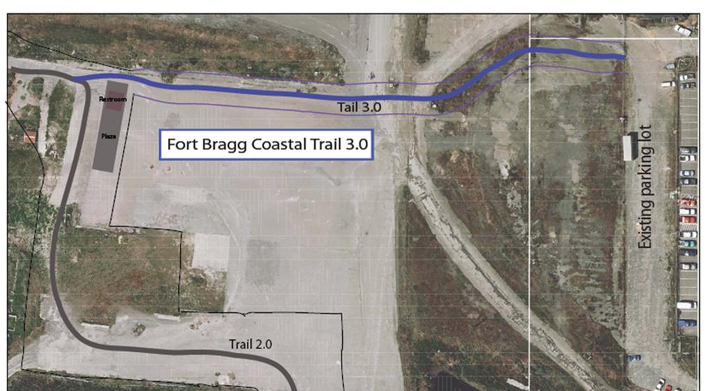
12 Agenda Date: 6/27/2018 In Control: Planning Commission City of Fort Bragg Text File File Number: Version: 1 Status: Business 416 N Franklin Street Fort Bragg, CA Phone: (707) Fax: (707) File Type: Planning Staff Report Agenda Number: 3A. Recieve Report and Consider Approval of Coastal Development Permit Amendment (CDP 10-10/14/14/18), Design Review Permit Amendment (DR 11-10/14/14/18) and SEIR Addendum for Phase III of the Fort Bragg Coastal Restoration and Trail Project, which consists of the installation of approximately 600 linear feet of a 12 foot wide asphalt trail that connects the Fort Bragg Coastal Trail project to downtown Fort Bragg via Alder Street and associated signage and property line fencing. City of Fort Bragg Page 1 Printed on 6/26/2018
13 MEETING DATE: June 27, 2018 PREPARED BY: PRESENTED BY: M. Jones M. Jones AGENDA ITEM SUMMARY REPORT APPLICATION NO.: Coastal Development Permit Amendment (CDP 10-10/14/14/18), Design Review Amendment (DR 11-10/14/14/18) APPLICANTS/OWNERS: City of Fort Bragg (Applicant) Georgia-Pacific (Owner) REQUEST: LOCATION: Coastal Development Permit & Design Review Permit for Phase III of the Fort Bragg Coastal Restoration and Trail Project. The proposed project would consist of the installation of approximately 600 linear feet of a 12 foot wide asphalt trail that connects the Fort Bragg Coastal Trail project to downtown Fort Bragg via Alder Street and associated signage and property line fencing. The project would include use of a pre-existing gravel covered parking lot of approximately 60 spaces, which is located between Alder and Oak Street west of Chief Cereli Drive. 90 West Redwood. The property is in the Coastal Zone. ASSESSOR S PARCEL NO.: ZONING: ENVIRONMENTAL DETERMINATION: (149 acres); and (4 acres) Timber Resources Industrial (IT) A Final Subsequent EIR has been prepared. SURROUNDING NORTH: Timber Resources Industrial (IT) LAND USES: EAST: Central Business District (CDB) SOUTH: Timber Resources Industrial (IT) WEST: Timber Resources Industrial (IT) APPEALABLE PROJECT: Can be appealed to California Coastal Commission as project is west of the westernmost public road and within 300 feet of a wetland. Fort Bragg Coastal Restoration and Trail Project Phase III Page 1 June 27, 2018 Agenda Item No. 3A
14 PROJECT BACKGROUND Since 2006, the City of Fort Bragg has been working to make the public acquisition, restoration, and development of a coastal park on a 93-acre site along the 3½ acres of coastline on the former Georgia-Pacific Mill Site a reality (see Attachment 1 for the Site Map). Many steps have been taken to move this project forward, including: The City has engaged the public at multiple points throughout this process. Since 2006, the City has held over 30 public meetings to obtain public input for the planning, design and environmental review of the Fort Bragg Coastal Restoration and Trail Project (project). In early 2010, the City purchased a portion of the site with $4,145,000 in State Coastal Conservancy funding to provide coastal access. Georgia-Pacific also donated a portion of the site to the City. In 2011, the City Council certified an Environmental Impact Report (EIR) for the project and the Planning Commission approved Coastal Development Permit (CDP 10-10), Design Review (DR 11-10), and Variance (VAR 2-11) for the construction of the project. Beginning in 2012, as part of federal environmental review (NEPA) process, the City met with Sherwood Valley Band of Pomo (SVBP) to redesign portions of the project to address Tribal concerns. In late 2013, staff prepared a Draft Subsequent EIR to analyze the proposed changes to the project. The Draft Subsequent EIR was the subject of a public hearing before City Council on January 13, In 2013 the City acquired the four acre Johnson Property (adjacent to the South Parkland parcel) with Coastal Conservancy funding for public access. In 2015, the City authorized the construction of Phase II of the Coastal Trail, which connected the north and south elements of the Phase I project, and the project was constructed in PERMIT HISTORY Coastal Development Permit (CDP 10-10), Design Review (DR 11-10), and Variance (VAR 2-11) were granted on August 24, 2011 to complete: 1) 20+ acres of habitat restoration; 2) construction of 4.5 miles of coastal trail, two parking lots with access road, storm drain improvements, three restrooms, benches, beach access stairs; and 3) installation of interpretive signage, resource protection fencing, site safety signage and welcome signage. Coastal Development Permit (CDP 3-11) was granted on September 14, 2011 to complete habitat restoration of approximately five acres of coastal habitat on Glass Beach Headlands, including the restoration and closure of five miles of volunteer trails and establishment of a two foot wide, 1,400 foot long official dirt trail. Restoration activities would include hand and mechanical removal of non-native plants, planting and propagation of native plants and restoration of eroded coastal bluffs and perched dunes. The restoration Fort Bragg Coastal Restoration and Trail Project Phase III Page 2 June 27, 2018 Agenda Item No. 3A
15 portion of CDP 3-11 has been constructed. State Parks has indicated that they will not build the two foot wide 1,400 foot long official dirt trail. Coastal Development Permit Amendment (CDP 10-10/14), Design Review Amendment (DR 11-10/14), and Variance Amendment (VAR 2-10/14) were approved in January of These amendments authorized changes to the project design to protect cultural resources and relocate the parking lot from Noyo Point Road to the end of the runway. Coastal Development Permit Amendment (CDP 10-10/14/14), Design Review Amendment (DR 11-10/14/14), and Variance Amendment (VAR 2-10/1414) were approved in January of These amendments authorized the construction of Phase II of the Coastal Trail. PROJECT DESCRIPTION The project is located on the Mendocino Coast within the City of Fort Bragg. The proposed project would consist of the installation of approximately 600 linear feet of a 12 foot wide asphalt trail that connects the Fort Bragg Coastal Trail project to downtown Fort Bragg via Alder Street and associated signage and property line fencing. The proposed project is illustrated in Figure 1. Figure 1: Phase III Coastal Trail Alignments Fort Bragg Coastal Restoration and Trail Project Phase III Page 3 June 27, 2018 Agenda Item No. 3A
16 Vehicular Access Vehicular access to Phase III of the Coastal Trail project will be limited to parking in an existing gravel parking lot located at the western terminus of Alder Street. No improvements are proposed for the parking lot. The existing parking lot will likely accommodate about 60 cars. Fencing Property line fencing will be located on both sides of the trail alignment. The property line fencing will include a set of gates for the use of GP s security to traverse the trail alignment to get from one side of GP s property to the other and for future access by any GP contractors or consultants. CONSISTENCY WITH THE ZONING CODE Land Use The proposed use of a park with a multi-use trail and associated support facilities is a permitted use in the Timber Resources Industrial Zone (IT) and lies within the Coastal Zone (CZ). The proposed development activities of nature preserve, parks and trails are permitted uses within the IT Zone. Zoning Standards Due to the type of project many of the zoning standards are not applicable to the proposed project. However, setbacks, height limits and fencing requirements are applicable. Standard Standard Proposed Condition Compliance Portion of the proposed trail located Yes, trails Setback front 15 feet from front on the eastern edge of the four acre are permitted property line. parcel ( ) will be within the located within setbacks. setback Setback & Rear s10 feet abutting IT The proposed trail will be located within the side setbacks. Fencing 5 feet - open 5 feet - open Yes Yes, trails are permitted within the setback Landscaping The project will not include landscaping. There are no landscaping standards ( ) that apply to parks. The project includes limited restoration of native vegetation along the sides of the trail in areas which are not currently paved. Outdoor Lighting The project will not include outdoor lighting. Fort Bragg Coastal Restoration and Trail Project Phase III Page 4 June 27, 2018 Agenda Item No. 3A


17 Parking The Coastal General Plan includes the following policy: Policy LU-5.7. Adequate parking should be provided to serve coastal access and recreation uses to the extent feasible. Existing parking areas serving recreational uses shall not be displaced unless a comparable replacement area is provided. Phase I of the Coastal Trail project provides 110 parking spaces in two lots. Phase II of the Coastal Trail did not include parking improvements. Phase III of the project will utilize an existing under-utilized gravel parking lot located between Alder and Oak Streets along the western edge of Chief Celeri Drive. The existing gravel parking lot provides space to park 60 vehicles as illustrated in Figure 2. Existing Parking Lot Parking Lot space illustration At this time the City is not seeking to improve the Alder Street parking lot. The City has entered into a renewable annual License Agreement for use of the parking lot, and as the City does not own the parking lot, significant City funded improvements to the Alder Street parking lot could be considered a gift of public funds to the property owner and should be avoided. Fort Bragg Coastal Restoration and Trail Project Phase III Page 5 June 27, 2018 Agenda Item No. 3A
18 The Coastal LUDC does not include parking requirements for passive recreation areas. The City must ensure that sufficient parking is provided for the facility. The City s two parking lots function adequately to serve existing demand. The South Trail Parking Lot has 66 parking spaces and typically is half full. The North Trail parking lot (64 parking spaces) is heavily utilized and filled by 10:00 or 11:00am due to the many visitors to Glass Beach. The Alder Street parking lot, with 60 spaces should adequately serve demand in this area, as many people will walk or bike to the facility from town. Additionally the visual qualities of this entrance are not as scenic as those from the other two entrances and so it is likely to have a lower rate of utilization. Fire and Life Safety. Fire safety is not a concern for this project as the site includes no new buildings and the site has no tree coverage. Life safety is also not a concern for this project as it is located well inland of bluffs and water features. Staff has worked with the Fire Department to ensure that the property line fence will have gates at appropriate locations to allow for a rapid response to emergency calls for rescue assistance from the coastal trail, bluffs, and ocean accessed by Phase II and Phase I of the project. Additionally, the project includes a variety of safety signs as discussed below. Trash & Recycled Materials Enclosure. The project will not include trash cans as there is a trash can be installed at the Welcome Plaza. This trash container is designed so that material cannot blow out of it. COASTAL DEVELOPMENT PERMIT ANALYSIS The Coastal General Plan also includes the following policy with regard to cultural resources: Policy OS-4.1. Preserve Archaeological Resources. New development shall be located and/or designed to avoid archaeological and paleontological resources where feasible, and where new development would adversely affect archaeological or paleontological resources, reasonable mitigation measures shall be required. The project has been designed to avoid cultural resources as it is located in an area without any known cultural resources. CULTURAL RESOURCES ( ) Coastal LUDC section requires that an archaeological report be prepared for any projects located on the former Georgia-Pacific Mill Site. A number of archaeological reports have been prepared for the overall Coastal Trail project because it is a site of archaeological resources, including: Data Collection Plan for the Fort Bragg Coastal Trail Project in the City of Fort Bragg, Thad VanBueren, 2014 Fort Bragg Coastal Restoration and Trail Project Phase III Page 6 June 27, 2018 Agenda Item No. 3A
19 Historic Property Treatment Plan for the Fort Bragg Coastal Trail Project in the City of Fort Bragg, Thad VanBueren, 2011 Combined Historic Property Survey report and Finding of Effect for the Fort Bragg Coastal Trail Project in the City of Fort Bragg, Thad VanBueren, January 2011 Historic Resources Evaluation Report for the Fort Bragg Coastal Trail Project in the City of Fort Bragg, Thad VanBueren, 2011 A Data Collection Plan is not required for this project as the project is located in a site without any known cultural resources. However mitigation measures were identified in the SEIR Addendum for this project that, if implemented, will ensure that impacts to cultural resources will be less than significant. Additionally, MM 2.7 below has been slightly reworded from the SEIR to be more restrictive at the request of the Sherwood Valley Band of Pomo. Mitigation Measure 2.5: The tribal monitors will be notified at least three weeks in advance of ground disturbing construction activities within ESA to ensure they will be available to monitor/review installation of ESA protection fencing. Mitigation Measure 2.6: One week prior to initiating any native soils disturbance in non-fill areas, SVR and Native American Monitors will be notified. Mitigation Measure 2.7: Native American monitors will be required where ground disturbing activities occur. Mitigation Measure 2.8: The Community Development Director will notify the State Historic Preservation Officer within 48 hours of any ESA violation or unanticipated discovery to determine how it will be addressed. Consultation with Native Americans shall also be included. Error! Reference source not found. (below) will ensure that these mitigation measures are implemented. 1. Error! Reference source not found. ENVIRONMENTALLY SENSITIVE HABITAT AREAS ( ) The project includes no Environmentally Sensitive Habitat Areas (ESHA) adjacent to the trail alignment. A number of biological reports were prepared for the project as required under Coastal LUDC Section (B). HAZARDS AND SHORELINE/BLUFF TOP DEVELOPMENT (17.54) Fort Bragg Coastal Restoration and Trail Project Phase III Page 7 June 27, 2018 Agenda Item No. 3A
20 The proposed project does not include any development within the bluff setback. retreat SHORELINE ACCESS (17.56) In the Coastal Zone, the LCP requires that the City evaluate potential impacts of new development to public access to the coast. The project will improve public access by providing 600 linear feet of multi-use trail to connect 6.4 miles of multiuse trails accessible to the downtown. The construction project would not interfere with public access to coastal and shoreline resources during construction as no access in the proposed trail location are currently allowed through this portion of the Mill Site. GRADING & EROSION CONTROL (17.62) The Coastal LUDC requires the preparation of a dust prevention and control plan, identification of best management practices for the prevention of erosion and sedimentation during construction prior to approval of a grading permit. Special Condition 2 has been added to ensure that these documents are submitted to the Department of Public Works and approved prior to issuance of the grading permit. Special Condition 2: Prior to issuance of the grading permit the applicant shall submit a dust prevention and control plan and shall identify best management practices for sedimentation and erosion control for approval by the Community Development Director. STORMWATER MANAGEMENT (17.64) Much of the site is currently surfaced with pavement or packed gravel. Stormwater currently sheet flows over impervious surfaces and to the mill pond. The proposed multi-use trail would be located parallel to the flow of water in areas of impervious surfaces and therefore will likely not be impacted by severe storm events. The Coastal LUDC requires preparation of a Stormwater Runoff Mitigation Plan prior to approval of the grading permit. Special Condition 3 has been added to ensure that this plan is prepared. Special Condition 3: Prior to issuance of the grading permit the applicant shall submit a Stormwater Runoff Mitigation Plan for approval by the Community Development Director. Adequacy of water supply, sewage disposal, solid waste, and public roadway capacity. The project does not include new facilities that would impact water supply, sewage disposal or roadway capacity. The project will produce minimal solid waste as most of the asphalt will be reground and re-used on site, while most of the gravel will remain in place. DESIGN REVIEW AND VISUAL ANALYSIS Fort Bragg Coastal Restoration and Trail Project Phase III Page 8 June 27, 2018 Agenda Item No. 3A
21 Design Review is intended to ensure that the design of proposed development and new land uses assists in maintaining and enhancing the small-town, coastal, historic, and rural character of the community. The site is part of a scenic visual corridor. However the project will largely improve the existing visual quality. The proposed improvements are generally limited to restoration, trails, minimum drainage improvements, and limited signage and habitat creation and revegetation of 7,800 SF of compacted gravel and asphalt on the site and thereby will significantly improve the visual quality of the area. Site Furniture The project will not include site furniture. Fencing The property line fencing will consist of T-posts with livestock wire which will have minimal impacts on visual resources and will be as unobtrusive as possible. The property line fencing will also include locked access gates to provide ready access to GP from one side of the Mill Site to the other. This fencing is appropriate to the project location and will reduce and minimize visual impacts while providing property security to adjacent property owners, and ease of entrance by emergency response vehicles. Additionally the proposed fencing approach matches the existing fencing for the Phase I and Phase II of the project. Landscaping The project includes no landscaping. Site restoration will take place over a period of two years and will include hydro-seeding with native seed and planting a limited number of small trees along the trail. The placement of trees will minimize impacts on ocean views while providing wind protection and some visual screening of the adjacent mill site property. Restoration Site restoration will include removal of the existing compacted gravel and asphalt and installation of a soil cap for restoration. Initially the project may have spotty success with restoration and habitat creation. The project incorporates adaptive management to improve restoration efforts over a four year timeframe. In the near term the restoration project may not look ideal from an aesthetic perspective. However, over time the project would include numerous acres of ecological restoration, which will improve the visual character of the site. The restoration project conforms with the Citywide Design Guidelines. Environmental Determination A Draft and Final Subsequent EIR have been prepared for the Phase II Fort Bragg Coastal Restoration and Trail Project. And SEIR Addendum has been prepared for Fort Bragg Coastal Restoration and Trail Project Phase III Page 9 June 27, 2018 Agenda Item No. 3A
22 Phase III of the project. If the project is approved, the City must implement all mitigation measures in the SEIR Addendum and, by doing so, the project will have a less than significant impact on the environment. PLANNING COMMISSION ACTION 1. Conduct the public hearing, close the hearing, deliberate, and consider making a motion to: 1) Adopt a Resolution of the Fort Bragg Planning Commission Certifying the Subsequent Environmental Impact Report Addendum for the Fort Bragg Coastal Restoration and Trail Phase III Project 2) Adopt a Resolution of the Fort Bragg Planning Commission to Approve Coastal Development Permit Amendment (CDP 10-10/14/14/18), Design Review Amendment (DR 11-10/14/14/18) for Phase III of the Fort Bragg Coastal Trail Project based on the findings and subject to the conditions cited. ALTERNATIVE ACTION 2. Hold the public hearing, close the hearing, deliberate without a decision, and continue action to a future meeting. 3. Hold the public hearing, and continue the hearing if there is insufficient time to obtain all input from all interested parties. RECOMMENDATION Staff recommends approval of Coastal Development Permit Amendment (CDP 10-10/14/14/18), and Design Review Amendment (DR 11-10/14/14/18) for the Fort Bragg Coastal Restoration and Trail Phase III Project based on the following findings and subject to the conditions cited below: GENERAL FINDINGS 1. The proposed project is consistent with the purpose and intent of the zoning district, as well as all other provisions of the Coastal General Plan, Coastal Land Use and Development Code (CLUDC) and the Fort Bragg Municipal Code in general. 2. The design, location, size, and operating characteristics of the proposed activity are compatible with the existing and future land uses in the vicinity. Fort Bragg Coastal Restoration and Trail Project Phase III Page 10 June 27, 2018 Agenda Item No. 3A
23 3. The site is physically suitable in terms of design, location, shape, size, operating characteristics, and the provision of public and emergency vehicle (e.g., fire and medical) access and public services and utilities (e.g., fire protection, police protection, potable water, schools, solid waste collection and disposal, storm drainage, wastewater collection, treatment, and disposal, etc.), to ensure that the type, density, and intensity of use being proposed would not endanger, jeopardize, or otherwise constitute a hazard to the public interest, health, safety, convenience, or welfare, or be materially injurious to the improvements, persons, property, or uses in the vicinity and zoning district in which the property is located. 4. The project complies with Specific Use Regulations established for the project. 5. For the purposes of the environmental determination, a Subsequent Environmental Impact Report Addendum was prepared and certified for the project in accordance with the Environmental Quality Act (CEQA). The City has passed a resolution to certify the Subsequent EIR Addendum which includes the requirement to implement the Mitigation and Monitoring Program for the project. COASTAL DEVELOPMENT PERMIT FINDINGS 1. The proposed development as described in the application and accompanying materials, as modified by any conditions of approval, is in conformity with the City of Fort Bragg s certified Local Coastal Program and will not adversely affect coastal resources. 2. The project is in conformity with the public access and recreation policies of Chapter 3 of the Coastal Act of 1976 (commencing with Sections of the Public Resources Code). 3. Feasible mitigation measures and/or alternatives have been incorporated to substantially lessen any significant adverse effects of the development on the environment. 4. The proposed use is consistent with the purposes of the zone in which the site is located. 5. The proposed development is in conformance with the City of Fort Bragg s Coastal General Plan. 6. The proposed location of the use and conditions under which it may be operated or maintained will not be detrimental to the public health, safety, or welfare, or materially injurious to properties or improvements in the vicinity. 7. Services, including but not limited to, water supply, sewage disposal, solid waste, and public roadway capacity have been considered and are adequate to serve the proposed development. 8. The project, as proposed, will neither be subject to nor increase instability of the site or structural integrity from geologic, flood, or fire hazards due to project design, location on the site, or other reasons. 9. The project, as conditioned, will not have significant adverse impacts on site stability or structural integrity from geologic, flood, or fire hazards due to required project modifications, landscaping, or other conditions. Fort Bragg Coastal Restoration and Trail Project Phase III Page 11 June 27, 2018 Agenda Item No. 3A
24 10. There are no alternatives to development that would avoid or substantially lessen impacts on site stability or structural integrity. 11. The resource as identified will not be significantly degraded by the proposed development. 12. There is no feasible less environmentally damaging alternative; and 13. All feasible mitigation measures capable of reducing or eliminating project related impacts have been adopted. DESIGN REVIEW FINDINGS 1. The project complies with the purpose and requirements of CLUDC Section 17/ Design Review; 2. The project provides architectural design, building massing, and scale appropriate to and compatible with the site surroundings and the community; 3. The project provides attractive and desirable site layout and design, including building arrangement, exterior appearance and setbacks, drainage, fences and walls, grading, landscaping, lighting, signs, etc.; 4. The project provides efficient and safe public access, circulation, and parking; 5. The project provides appropriate open space and landscaping, including the use of water efficient landscaping; 6. The project is consistent with the Coastal General Plan, any applicable specific plan, and the certified Local Coastal Program; and 7. The project complies and is consistent with the City's Design Guidelines. SPECIAL CONDITIONS 1. The applicant shall implement all mitigation measures identified in the Subsequent Environmental Impact Report (SEIR) Addendum for this project and listed in the Final Mitigation and Monitoring Plan for the project. 2. Special Condition 2: Prior to issuance of the grading permit the applicant shall submit a dust prevention and control plan and shall identify best management practices for sedimentation and erosion control for approval by the Community Development Director. 3. Special Condition 3: Prior to issuance of the grading permit the applicant shall submit a Stormwater Runoff Mitigation Plan for approval by the Community Development Director. STANDARD CONDITIONS 1. This action shall become final on the 11 th day following the decision unless an appeal to the Coastal Commission is filed pursuant to Coastal Land Use & Development Code (CLUDC) Chapter Appeals. Fort Bragg Coastal Restoration and Trail Project Phase III Page 12 June 27, 2018 Agenda Item No. 3A
25 2. The use and occupancy of the premises shall be established and maintained in conformance with the requirements of this permit and all applicable provisions of the CLUDC. 3. The application, along with supplemental exhibits and related material, shall be considered elements of this permit, and compliance therewith is mandatory, unless an amendment has been approved by the City. 4. This permit shall be subject to the securing of all necessary permits for the proposed development from City, County, State, and Federal agencies having jurisdiction. All plans submitted with the required permit applications shall be consistent with this approval. All construction shall be consistent with all Building, Fire, and Health code considerations as well as other applicable agency codes. 5. The applicant shall secure all required building permits for the proposed project as required by the Mendocino County Building Department. 6. If any person excavating or otherwise disturbing the earth discovers any archaeological site during project construction, the following actions shall be taken: 1) cease and desist from all further excavation and disturbances within 100 feet of the discovery; and 2) notify the Director of Public Works within 24 hours of the discovery. Evidence of an archaeological site may include, but is not necessarily limited to shellfish, bones, flaked and ground stone tools, stone flakes produced during tool production, historic artifacts, and historic features such as trash-filled pits and buried foundations. A professional archaeologist on the list maintained by the Northwest Information Center of the California Historical Resources Information System or Listed by the Register of Professional Archaeologists shall be consulted to determine necessary actions. 7. This permit shall be subject to revocation or modification upon a finding of any one or more of the following: (a) That such permit was obtained or extended by fraud. (b) That one or more of the conditions upon which such permit was granted have been violated. (c) That the use for which the permit was granted is so conducted as to be detrimental to the public health, welfare, or safety or as to be a nuisance. (d) A final judgment of a court of competent jurisdiction has declared one or more conditions to be void or ineffective, or has enjoined or otherwise prohibited the enforcement or operation of one or more conditions. 8. Unless a condition of approval or other provision of the Coastal Land Use and Development Code establishes a different time limit, any permit or approval not exercised within 24 months of approval shall expire and become void, except where an extension of time is approved in compliance with CLUDC Subsection 17/ (B). ATTACHMENTS 1. Site Location Map 2. Site Plan Fort Bragg Coastal Restoration and Trail Project Phase III Page 13 June 27, 2018 Agenda Item No. 3A
26 3. Site Photos 4. Fort Bragg Coastal Restoration and Trail Project Phase III Final Subsequent Environmental Impact Report Addendum 5. Resolution of the Fort Bragg Planning Commission Certifying the Subsequent Environmental Impact Report Addendum for the Fort Bragg Coastal Restoration and Trail Phase III Project 6. Resolution of the Fort Bragg Planning Commission to Approve Coastal Development Permit Amendment (CDP 10-10/14/14/18), Design Review Amendment (DR 11-10/14/14/18) for Phase III of the Fort Bragg Coastal Trail Project Fort Bragg Coastal Restoration and Trail Project Phase III Page 14 June 27, 2018 Agenda Item No. 3A

27 Attachment 1 - Coastal Trail Phase II- Location Map
28


29


30


31


32


33


34


35
36 ADDENDUM TO THE FINAL SUBSEQUENT ENVIRONMENTAL IMPACT REPORT FORT BRAGG COASTAL RESTORATION AND TRAIL PROJECT PHASE II PROJECT June 27, 2018 I. INTRODUCTION Pursuant to the provisions of the California Environmental Quality Act (CEQA), the City of Fort Bragg, (City), acting in the capacity of Lead Agency, distributed a Draft Subsequent Environmental Impact Report (State Clearinghouse No.: ) for the Fort Bragg Coastal Restoration and Trail Project Phase II (Coastal Trail) for public review and comment from November 25, 2014 to January 8, The Final Subsequent Environmental Impact Report (SEIR) was certified by the City on January 12, This Addendum has been prepared to supplement the project description and the analysis in the SEIR. The City has determined that an Addendum is the appropriate subsequent CEQA document for the Coastal Trail Phase III Project per the CEQA Guidelines [Cal. Code Regs., tit. 14, 15164(b)] because none of the conditions described in Section of the CEQA guidelines apply. Pursuant to Section 15164(c) of the CEQA Guidelines, this Addendum is not being circulated for public review and comment, but will be attached to the Final SEIR. A Notice of Determination will be filed with the State of California Office of Planning and Research, State Clearinghouse following approval of the Coastal Development Permit. II. BACKGROUND The SEIR for the Coastal Trail Project evaluated impacts resulting from restoration, construction of a multi-use trail, installation of pedestrian-only side trails, and installation of related improvements. The restoration encompassed approximately five acres and involved creating locally appropriate native habitats and the importation of approximately 5,000 cubic yards of a mix of sand, soil and composted grain/woodchips for restoration purposes. The multi-use trail is 1.2 miles in length and 8 feet wide, and was constructed on top of existing developed areas throughout the length of the project site. III. PURPOSE OF ADDENDUM AND CEQA REQUIREMENTS The purpose of this Addendum is to address the environmental effects of construction of a 600 linear foot extension of the Multi Use Trail between the welcome plaza and Alder Street. As set forth in the Explanation of Significant Differences, in order to determine whether any significant environmental impacts which were not identified in the SEIR would result, or, whether previously identified significant impacts would be substantially more severe. This document has been prepared in accordance with the CEQA Guidelines, [Cal. Code Regs., tit. 14, and 15162]. The CEQA Guidelines[Cal. Code Regs., tit. 14, 15162(a)] provides that, for a project covered by a certified Environmental Impact Report (EIR) or adopted negative declaration, preparation of a Coastal Trail Phase III Project: SEIR Addendum 1
37 subsequent EIR or negative declaration rather than an Addendum is required only if one or more of the following conditions occur: 1. Substantial changes are proposed in the project which will require major revisions of the previous EIR or negative declaration due to the involvement of new significant environmental effects or a substantial increase in the severity of previously identified significant effects; 2. Substantial changes occur with respect to the circumstances under which the project is undertaken which will require major revisions of the previous EIR or negative declaration due to the involvement of new significant environmental effects or a substantial increase in the severity of the previously identified significant effects; or 3. New information of substantial importance, which was not known and could not have been known with the exercise of reasonable diligence at the time of the previous EIR was certified as complete or the negative declaration was adopted, shows any of the following: a) The project will have one or more significant effects not discussed in the previous EIR or negative declaration; b) Significant effects previously examined will be substantially more severe than shown in the previous EIR or negative declaration; c) Mitigation measures or alternatives previously found not to be feasible would in fact be feasible and would substantially reduce one or more significant effects of the project, but the project proponents decline to adopt the mitigation measure or alternative; or d) Mitigation measures or alternatives which are considerably different from those analyzed in the previous EIR or negative declaration would substantially reduce one or more significant effects on the environment, but the project proponents decline to adopt the mitigation measures or alternative. Cal. Code Regs.,tit., 15164(a) and (b) of the CEQA Guidelines state: (a) The lead agency or a responsible agency shall prepare an addendum to a previously certified EIR if some changes or additions are necessary but none of the conditions described in Section calling for preparation of a subsequent EIR have occurred. (b) An addendum to an adopted negative declaration may be prepared if only minor technical changes or additions are necessary or none of the conditions described in Section calling for the preparation of a subsequent EIR or negative declaration have occurred. (underline added) Based on the analysis presented herein, it has been determined that an Addendum to the SEIR is the appropriate CEQA document to address the CDP Coastal Trail Phase III project given that none of the conditions described in the CEQA Guidelines [ Cal. Code Regs., tit. 14, 15162] Coastal Trail Phase III Project: SEIR Addendum 2

38 calling for the preparation of a subsequent EIR or negative declaration have occurred, but that there are changes and additions necessary to attach to the certified SEIR. The environmental analysis relies on the analyses completed in the SEIR and directly references the SEIR where appropriate. IV. APPLICATION OF PREVIOUSLY CERTIFIED ENVIRONMENTAL DOCUMENTATION TO Coastal Trail Phase III Project Description of Coastal Trail Phase III The proposed project would consist of the installation of approximately 600 linear feet of a 12 foot wide asphalt trail that connects the Fort Bragg Coastal Trail project to downtown Fort Bragg via Alder Street and associated signage and property line fencing (Figure 1). The proposed project would include limited removal of existing paved areas, some grading and installation of the trail. The project would also include installation of property line fencing and limited signage (welcome sign and rules signs). Figure 1: Coastal Trail Phase III project (illustrated in blue). And a portion of the Phase II Coastal Trail Project illustrated in black Environmental Impact Analysis As noted previously, the construction of Phase III of the coastal trail was not included in the SEIR. However, the activities of the Coastal Trail construction project will not impact the following issue areas and there will be no change to the analyses and findings presented in the SEIR: aesthetics, agricultural resources, geology and soils, land use and planning, mineral Coastal Trail Phase III Project: SEIR Addendum 3
39 resources, population and housing, public services, recreation, and utilities and service systems. In addition, the Phase III Coastal Trail project will have no new significant impacts associated with: air quality and greenhouse gases (GHGs), biological resources, cultural resources, hazards and hazardous materials, hydrology and water quality, noise, and transportation and traffic. Therefore, the impacts associated with the Coastal Trail Phase III project for these issue areas will be within the scope of impacts identified in the SEIR, as described below. A. Cultural Resources The SEIR concluded the project s impact on Cultural Resources was less than significant with mitigation incorporated. The Mill Site inlcudes an archaeologically sensitive area, as the Fort Bragg Native American Archaeological District reflects persistent and intensive Native American use of two sites found within the Coastal Trail project area. The archaeological district is also a Traditional Cultural Property for members of the Sherwood Valley Rancheria. Given the sensitivity of the area, there is some potential for archaeological resources to be discovered during construction activities. The Georgia-Pacific Lumber Mill property is not eligible for listing in the CRHR or NRHP as a historic district, as 21 of the 22 historic district contributors have been demolished since There are also no remaining historic buildings within the project site. Due to the presence of tribal cultural resources, the City engaged in consultation with the Sherwood Valley Band of Pomo Indians (SVBP) in 2012, 2013, 2014 and 2016 regarding Phase I and Phase II of the Coastal Trail project. The project site has no known cultural resource or cultural resource sites. Never the less as the project will include ground disturbing activities Mitigation Measure were identified in the SEIR to reduce the potential impacts to a less-than-significant level and mitigation measures 2.5, 2.6, 2.7 & 2.8 are relevant to the proposed project as noted below. Additionally MM 2.7 has been made more restrictive that the SEIR by requiring Native American Monitors for all ground disturbing activities, not just those involving undisturbed soils. Mitigation Measure 2.5: The tribal monitors will be notified at least three weeks in advance of ground disturbing construction activities within ESA to ensure they will be available to monitor/review installation of ESA protection fencing. Mitigation Measure 2.6: One week prior to initiating any native soils disturbance in non-fill areas, SVR and Native American Monitors will be notified. Mitigation Measure 2.7: Native American monitors will be required where ground disturbing activities occur. Mitigation Measure 2.8: The Community Development Director will notify the State Historic Preservation Officer within 48 hours of any ESA violation or unanticipated discovery to determine how it will be addressed. Consultation with Native Americans shall also be included. Coastal Trail Phase III Project: SEIR Addendum 4
40 B. Hazards and Hazardous Materials The SEIR concluded that the Coastal Trail project s potential to expose visitors to hazardous substances within the soil and sediment would be a less-than-significant impact. In addition, any potential impacts to construction workers for the Coastal Trail project would be mitigated through compliance with the DTSC-approved Soil Management Plan for the site. Other hazardous materials may be handled during fueling and servicing of construction equipment, but the SEIR concluded that no adverse impacts would result. Additionally, since completion of the SEIR, the department of Toxics and Substances Control (DTSC) has determined that the area proposed for the Coastal Trail Phase III project has been remediated to a level that would accommodate unrestricted use and is under consideration for a no further action determination. Therefore, the proposed project would not expose people or the environment to a significant hazard related to hazardous materials sites subject to Cortese List requirements. The following Mitigation Measures form the SEIR are relevant to the project: Mitigation Measure 8: DTSC may require, through its CEQA document for the RAP for Operable Unit E, that construction projects which include grading must comply with a Soil Management Plan (SMP) prepared for the site. Compliance with the SMP will also be a condition of approval for the grading permit for the site. C. Air Quality and Greenhouse Gas Emissions The SEIR noted that Mendocino County is considered a non-attainment area for particulate matter less than 10 microns in size (PM 10) under the California Clean Air Act standard. However, the SEIR concluded that the dust generated during construction and grading activities and construction period air pollutant emissions for the development of the proposed project would not exceed criteria pollutant daily emissions thresholds established by the Mendocino County Air Quality Management District (MCAQMD) or the Federal Environmental Protection Agency (EPA). The SEIR concluded that Coastal Trail project activities are in accordance with the existing MCAQMD plans and rules, and also determined that there is no impact with regard to exposure of sensitive receptors to substantial objectionable odors. The SEIR provided Mitigation Measure 9 to reduce any impacts to PM 10 to a less-than-significant level. The SEIR concluded that the Coastal Trail project activities will contribute a relatively small amount of Green House Gas (GHG) emissions; however the amount is not significant. Operationally while there is parking associated with the multi-use trail project, it will not result in additional vehicular trips, as people who seek to use the Coastal Trail would park in one of the proposed existing lots, absent the proposed project. Therefore the project is not anticipated to have new or additional impacts on Air Quality of Green House Gas Emissions. The following Mitigation Measure from the SEIR applies to the Coastal Trail Phase III project. Mitigation Measure 9: The project contractor, on behalf of the project applicant, shall prepare a dust control plan for construction activities at the project site pursuant to the requirements of the MCAQMD. The project contractor shall be responsible for ensuring that Coastal Trail Phase III Project: SEIR Addendum 5
41 all adequate dust control measures are implemented in a timely manner during all phases of construction and maintenance activities at the project site. The dust control plan shall include, at minimum, the following measures: a. Water shall be applied by means of truck(s), hoses, and/or sprinklers as needed prior to any land clearing or earth movement to minimize dust emissions. b. All material excavated, stockpiled, or graded shall be sufficiently watered to prevent fugitive dust from leaving the property boundaries or causing a public nuisance of an ambient air standard. Watering should occur at least twice daily, however frequency of watering shall be based on the type of operation, soil, and wind exposure. c. All on-site vehicle traffic shall be limited to a speed of 15 miles per hour (mph) on unpaved roads. d. All trucks hauling soil, sand, or other loose materials on public roads will be covered or required to maintain at least 2 ft. of freeboard. e. Excavation and grading activities shall be suspended when sustained winds exceed 25 mph, instantaneous gusts exceed 35 mph, or dust from construction might obscure driver visibility on public roads. f. All inactive portions of the construction site, including soil stockpiles, shall be covered, seeded, or watered until a suitable cover is established. g. Paved areas adjacent to construction sites (e.g. the abandoned runway) shall be swept or washed as required to remove excess accumulations of silt and/or mud, which may have resulted from grading and construction activities at the project site. D. Biological Resources The SEIR concluded that there were less-than-significant impacts to Environmentally Sensitive Habitat Areas (ESHAs), three special-status plant species with known populations within the Biological Study Area (BSA), 10 special-status animal species and/or types, and nesting birds protected under the federal Migratory Bird Treaty Act. All impacts included associated mitigation to result in a determination of less than significant. The BSA, which includes the project site, was identified as containing United States Army Corps of Engineers (USACE) jurisdictional wetlands, potential USACE wetlands, drainages, riparian areas under California Department of Fish & Wildlife (CDFW) jurisdiction, and California Coastal Commission wetlands. In addition, eight acres of ESHA wetlands were found within the Study Area, however the Coastal Trail project was designed to avoid the wetlands and any impacts were not reviewed in the SEIR. Temporary staging areas will be located within areas which are paved and part of or immediately adjacent to the project site. The Coastal Trail Phase III project would be located on areas of asphalt and heavily disturbed non-native vegetation composed primarily of weeds. The project site does not include and is not adjacent to any environmentally sensitive habitat area. None of the proposed activities are located within or adjacent to any wetlands. The trail corridor is located at its closest point 250 feet from any wetland. Therefore, the Phase III project will not alter the impact findings for biological resources presented in the SEIR. The inclusion of the following mitigation measures will provide clarifying Coastal Trail Phase III Project: SEIR Addendum 6
42 information for construction activities related to the implementation of the Phase III project: Mitigation Measure 14: During construction, to control erosion during and after project implementation, the applicant and contractors will implement standard Best Management Practices (BMPs) Mitigation Measure 15: During construction, the cleaning and refueling of equipment will occur only within a designated staging area and at least 65 ft. from wetlands, other waters, or other aquatic areas. This staging area will conform to BMPs applicable to attaining zero discharge of stormwater runoff. At a minimum, all equipment and vehicles will be checked and maintained on a daily basis to ensure proper operation and avoid potential leaks or spills. E. Hydrology and Water Quality The SEIR concluded that there would be no impact to water quality standards, waste discharge requirements, and the project would not otherwise substantially degrade water quality. In addition, there would be no alteration of the existing drainage pattern of the Site, contribution of runoff which would result in exceeding the capacity of existing or planned stormwater drainage systems, or contribution of substantial additional sources of polluted runoff. The project site is located within a 500 year floodplain, except for the beach berm and the beach which are subject to Flood Zone V, consisting of coastal flood with velocity hazard (wave action). To mitigate for potential impacts that would expose people to potential coastal flooding, the SEIR includes measures to install signage to warn people of high surf conditions during storm events along all improvements on the Beach Berm, and to temporarily close the berm section of the project trail and access to the beach in high surf conditions. The proposed project would result in a net reduction of imperious surfaces and thus should improve stormwater infiltration. Additionally the project will not result in significant grading or disturbance of existing stormwater flows. Therefore the project will not have a significant impact on stormwater releases and no additional mitigations are required. F. Noise The SEIR concluded that noise generated by the proposed Coastal Trail project would be short term and construction-related (paving, haul trucks for restoration materials, etc.). Construction will not include pile driving or use of explosives for demolition, activities which are most likely to exceed noise thresholds and result in intensive vibration. No long term noise impacts would result from the proposed project, and no mitigation measures are required. Therefore, there is no impact with regard to noise. The proposed Phase III construction project will be short in duration and the hours of operation will be limited to 7:30am and 5:00pm. Noise from the associated activities will comply with the City s Noise Ordinance; therefore, the increase in ambient noise levels associated with construction of the proposed project is expected to be minimal and is considered less than significant. Coastal Trail Phase III Project: SEIR Addendum 7
43 G. Transportation and Traffic The SEIR concluded that the Coastal Trail project activities would result in no impact with regard to transportation and traffic. The project will not provide any direct automobile access or additional parking for the site, and would not create a substantial increase in traffic in relation to existing traffic load and capacity or exceed a level of service standard for congestion of roadways. It was concluded that activities would not interfere with emergency access, result in inadequate parking capacity, or conflict with alternative transportation. The Final SEIR did not include an analysis of the vehicle trips to a new parking lot at the western terminus of Alder and Oak Streets. The proposed project is anticipated to attract 50 vehicles per hour at peak use times based on use levels at the other two parking lots and the relatively less picturesque access available from this entrance. Further the vehicular access will be split between the two intersections with about 35 vehicles/hr. accessing the site from Oak Street and 15 vehicles/hr. accessing the site from Alder street. The Oak Street intersection at highway 1 is signalized and operates at a LOS of A. Thirtyfive additional vehicles per hour through this intersection will not have a significant impact on this Level of Service. The Alder Street intersection is not signalized. The current LOS at the Alder Street intersection is level B. The addition of 15 vehicles/hr to this intersection will not reduce the LOS. Therefore, the Coastal Trail Phase III Project will not alter the impact findings for transportation and traffic presented in the SEIR. IV. CONCLUSION The Coastal Trail Phase III project will not alter the impact findings and mitigation measures for air quality and GHGs, biological resources, cultural resources, hazards and hazardous materials, hydrology and water quality, noise, and transportation and traffic presented in the SEIR. With adoption of the mitigation measures outlined above for this project, there will be no new significant impacts and no substantial increase in the severity of any impacts identified in the SEIR. The mitigation measures which are included in Section III are measures which address an impact already reviewed and mitigated within the SEIR. Therefore, the impacts for the OU-E RAW are within the scope of impacts identified in the SEIR, and the SEIR adequately addressed all potentially significant environmental impacts of the project. Based on the above, an Addendum is the appropriate CEQA document for the Coastal Trail Phase III project pursuant to the CEQA Guidelines [Cal. Code Regs., tit. 14, 15164(b)] because none of the conditions described in Section of the CEQA Guidelines calling for the preparation of a subsequent EIR or negative declaration have occurred. This addendum has appropriately disclosed the potential impacts from the Coastal Trail Phase III project and will be included as part of the CEQA record for the Coastal Restoration and Trail Project. A Notice of Determination for this Addendum to the SEIR will be filed with the California State Clearinghouse within the State of California Office of Planning and Research. CERTIFICATION Coastal Trail Phase III Project: SEIR Addendum 8
44 I hereby certify that the statements furnished above and in the exhibits, attached or incorporated by reference, present the data and information required for this evaluation to the best of my ability and that the facts, statements, and information presented are true and correct to the best of my knowledge and belief. Signature Date Marie Jones, Community Development Director
45 RESOLUTION NO. PC A RESOLUTION OF THE FORT BRAGG PLANNING COMMISSION A) CERTIFYING THE SUBSEQUENT ENVIRONMENTAL IMPACT REPORT FOR THE FORT BRAGG COASTAL RESTORATION AND TRAIL PHASE III PROJECT; B) ADOPTING THE CALIFORNIA ENVIRONMENTAL QUALITY ACT FINDINGS; AND C) ADOPTING MITIGATION MONITORING AND REPORTING PROGRAM WHEREAS, the City of Fort Bragg ( City ) proposes to develop a Trail Connection on an approximately 1 acre site ( Project Site ) between Phase II of the Coastal Trail and Downtown Fort Bragg. The Project Site is bordered on the west by Fort Bragg Coastal Trail, on the North and South by the Georgia-Pacific Mill Site, on the east by downtown Fort Bragg; and WHEREAS, the project ( Project ) is proposed to consist of the following: 1) construction of a 600 foot long 12 foot wide multi-use trail that would connect the Phase II Fort Bragg Coastal Trail project to downtown; and 3) installation of related improvements such as property line fencing, gates, safety signage and welcome panels; and WHEREAS, the California Environmental Quality Act, Public Resources Code, Section et seq. ( CEQA ), requires that the City consider the environmental effects of the Project prior to approving any entitlements for the Project; and WHEREAS, on August 8, 2011, the City Council certified an Environmental Impact Report (EIR) for the Project pursuant to CEQA; Title 14, California Code of Regulations, Section et seq. ("CEQA Guidelines"); and the City s CEQA Implementation Procedures; and WHEREAS, on August 24, 2011, the Planning Commission approved Coastal Development Permit (CDP 10-10), Design Review (DR 11-10), and Variance (VAR 2-11) ; and WHEREAS, on August 8, 2011, the City Council certified an Environmental Impact Report (EIR) for the Project pursuant to CEQA Guidelines; and the City s CEQA Implementation Procedures; and WHEREAS, between August 2011 and February of 2014 the City of Fort Bragg engaged in Consultation with the Sherwood Valley Band of Pomo and redesigned the project to address tribal concerns; and WHEREAS, on February 10, 2014, the City Council approved Coastal Development Permit (CDP 10-10/14), Design Review (DR 11-10/14), and Variance (VAR 2-11/14); and WHEREAS, on February , the City Council certified a Subsequent Environmental Impact Report (SEIR) for the Project pursuant to CEQA; Title 14, California Code of Regulations, Section et seq. ("CEQA Guidelines"); and the City s CEQA Implementation Procedures; and WHEREAS, on January 12, 2015, the City Council approved Coastal Development Permit (CDP 10-10/14/15), Design Review (DR 11-10/14/14), and Variance (VAR 2-11/14/14); and - 1 -
46 WHEREAS, on January , the City Council certified a Subsequent Environmental Impact Report (SEIR) for the Project pursuant to CEQA; Title 14, California Code of Regulations, Section et seq. ("CEQA Guidelines"); and the City s CEQA Implementation Procedures; and WHEREAS, the City intends to expand the scope of this project to include an addition 600 linear feet of trail as described above; and WHEREAS, the City prepared a Subsequent Environmental Impact Report Addendum for the Project pursuant to CEQA; Title 14, California Code of Regulations, Section et seq. ("CEQA Guidelines"); and the City s CEQA Implementation Procedures; and WHEREAS, on June 27, 2017, the Planning Commission held a noticed public hearing, received public testimony and considered all information related to the Fort Bragg Coastal Restoration and Trail Phase III Project Subsequent EIR Addendum, including all reports and attachments prepared or presented by City staff, pertinent documents provided during previous public meetings, all oral and written testimony and the full record of proceedings on the Project. NOW, THEREFORE, BE IT RESOLVED, by the Planning Commission of the City of Fort Bragg, that the Planning Commission finds, determines and certifies as follows: 1. The above recitals are true and correct, and are incorporated herein by reference. 2. The SEIR Addendum was prepared in compliance with the requirements of CEQA. 3. The SEIR Addendum was presented to the Planning Commission, the decision-making body for the City, the lead agency for the Project, and the Planning Commission has reviewed and considered the information contained in the Subsequent EIR Addendum. 4. The SEIR Addendum reflects the Planning Commission s independent judgment and analysis as to the environmental effects of the Project. 5. The Planning Commission hereby adopts the findings of the SEIR, incorporated herein by reference, regarding changes or alterations which have been incorporated into the Project which mitigate or avoid significant effects. 6. A number of impacts analyzed under the Subsequent EIR were found to be less than significant even without mitigation. 7. After mitigation, all project impacts are less than significant. 8. The Planning Commission has, by its review of the evidence and analysis presented in the SEIR Addendum and in the record, acquired a better understanding of the full scope of the environmental issues presented by the Project. In turn, this understanding has enabled the Commission to make fully informed, thoroughly considered decisions on these important issues. 9. The location of the documents or other material that constitute the record of proceedings upon which the decision is based is the City of Fort Bragg Community Development Department, 416 North Franklin Street, Fort Bragg CA 95437; the official custodian of said records is the City Clerk of the City of Fort Bragg
47 BE IT FURTHER RESOLVED that the Mitigation Monitoring and Reporting Program ( MMRP ) set forth in Subsequent EIR and incorporated herein by reference is hereby adopted to ensure that all mitigation measures relied on in the findings are fully implemented. Compliance with the MMRP shall be a condition of any Project approval. The above and foregoing Resolution was introduced by Planning Commissioner, seconded by Planning Commissioner, and passed and adopted at a regular meeting of the Planning Commission of the City of Fort Bragg held on the 27 th day of June, 2017, by the following vote: AYES: NOES: ABSENT: ABSTAIN: ATTEST: Teresa Rodriguez, Chair Johanna Gonzalez, Administrative Assistant - 3 -
48 RESOLUTION NO RESOLUTION OF THE FORT BRAGG PLANNING COMMISSION TO APPROVE COASTAL DEVELOPMENT PERMIT AMENDMENT (CDP 10-10/14/14/18), DESIGN REVIEW AMENDMENT (DR 11-10/14/14/18) FOR PHASE III OF THE FORT BRAGG COASTAL TRAIL PROJECT WHEREAS, the City of Fort Bragg ( City ) proposes to develop a Trail Connection on an approximately 1 acre site ( Project Site ) between Phase II of the Coastal Trail and Downtown Fort Bragg. The Project Site is bordered on the west by Fort Bragg Coastal Trail, on the North and South by the Georgia-Pacific Mill Site, on the east by downtown Fort Bragg; and WHEREAS, the project ( Project ) is proposed to consist of the following: 1) construction of a 600 foot long 12 foot wide multi-use trail that would connect the Phase II Fort Bragg Coastal Trail project to downtown; and 3) installation of related improvements such as property line fencing, gates, safety signage and welcome panels; and WHEREAS, the California Environmental Quality Act, Public Resources Code, Section et seq. ( CEQA ), requires that the City consider the environmental effects of the Project prior to approving any entitlements for the Project; and WHEREAS, on August 8, 2011, the City Council certified an Environmental Impact Report (EIR) for the Project pursuant to CEQA; Title 14, California Code of Regulations, Section et seq. ("CEQA Guidelines"); and the City s CEQA Implementation Procedures; and WHEREAS, on August 24, 2011, the Planning Commission approved Coastal Development Permit (CDP 10-10), Design Review (DR 11-10), and Variance (VAR 2-11) ; and WHEREAS, on August 8, 2011, the City Council certified an Environmental Impact Report (EIR) for the Project pursuant to CEQA Guidelines; and the City s CEQA Implementation Procedures; and WHEREAS, between August 2011 and February of 2014 the City of Fort Bragg engaged in Consultation with the Sherwood Valley Band of Pomo and redesigned the project to address tribal concerns; and WHEREAS, on February 10, 2014, the City Council approved Coastal Development Permit (CDP 10-10/14), Design Review (DR 11-10/14), and Variance (VAR 2-11/14); and WHEREAS, on February , the City Council certified a Subsequent Environmental Impact Report (SEIR) for the Project pursuant to CEQA; Title 14, California Code of Regulations, Section et seq. ("CEQA Guidelines"); and the City s CEQA Implementation Procedures; and WHEREAS, on January 12, 2015, the City Council approved Coastal Development Permit (CDP 10-10/14/15), Design Review (DR 11-10/14/14), and Variance (VAR 2-11/14/14); and - 1 -
49 WHEREAS, on January , the City Council certified a Subsequent Environmental Impact Report (SEIR) for the Project pursuant to CEQA; Title 14, California Code of Regulations, Section et seq. ("CEQA Guidelines"); and the City s CEQA WHEREAS, the City intends to expand the scope of this project to include an addition 600 linear feet of trail as described above; and WHEREAS, the City prepared a Subsequent Environmental Impact Report Addendum for the Project pursuant to CEQA; Title 14, California Code of Regulations, Section et seq. ("CEQA Guidelines"); and the City s CEQA Implementation Procedures; and WHEREAS, Planning Commission held a public hearing on June 27, 2018 regarding the City s request for a Coastal Development Permit Amendment (CDP 10-10/14/14/18), Design Review Amendment (DR 11-10/14/14/18) for the above described project; and WHEREAS, Planning Commission has reviewed the staff report prepared for this project (Staff Report for Coastal Development Permit Amendment (CDP 10-10/14/14/18), Design Review Amendment (DR 11-10/14/14/18) and incorporated it by reference; and WHEREAS, on June 27, 2018, the Planning Commission held a noticed public hearing, received public testimony and considered all information related to the Fort Bragg Coastal Restoration and Trail Project Phase III permit amendments, including the staff report, and all attachments prepared or presented by City staff, pertinent documents provided during previous public meetings, all oral and written testimony and the full record of proceedings on the Project to date. NOW, THEREFORE, BE IT RESOLVED, by the Planning Commission of the City of Fort Bragg approves Coastal Development Permit Amendment (CDP 10-10/14/14/18), and Design Review Amendment (DR 11-10/14/14/18) for the Fort Bragg Coastal Restoration and Trail Phase II Project based on the following findings and subject to the conditions and Special Conditions cited below: GENERAL FINDINGS 1. The proposed project is consistent with the purpose and intent of the zoning district, as well as all other provisions of the Coastal General Plan, Coastal Land Use and Development Code (CLUDC) and the Fort Bragg Municipal Code in general. 2. The design, location, size, and operating characteristics of the proposed activity are compatible with the existing and future land uses in the vicinity. 3. The site is physically suitable in terms of design, location, shape, size, operating characteristics, and the provision of public and emergency vehicle (e.g., fire and medical) access and public services and utilities (e.g., fire protection, police protection, potable water, schools, solid waste collection and disposal, storm drainage, wastewater collection, treatment, and disposal, etc.), to ensure that the type, density, and intensity of use being proposed would not endanger, jeopardize, or otherwise constitute a hazard to the public interest, health, safety, convenience, or welfare, or be materially injurious to the improvements, persons, property, or uses in the vicinity and zoning district in which the property is located. 4. The project complies with Specific Use Regulations established for the project. 5. For the purposes of the environmental determination, a Subsequent Environmental Impact Report Addendum was prepared and certified for the project in accordance with - 2 -
50 the Environmental Quality Act (CEQA). The City has passed a resolution to certify the Subsequent EIR Addendum which includes the requirement to implement the Mitigation and Monitoring Program for the project. COASTAL DEVELOPMENT PERMIT FINDINGS 1. The proposed development as described in the application and accompanying materials, as modified by any conditions of approval, is in conformity with the City of Fort Bragg s certified Local Coastal Program and will not adversely affect coastal resources. 2. The project is in conformity with the public access and recreation policies of Chapter 3 of the Coastal Act of 1976 (commencing with Sections of the Public Resources Code). 3. Feasible mitigation measures and/or alternatives have been incorporated to substantially lessen any significant adverse effects of the development on the environment. 4. The proposed use is consistent with the purposes of the zone in which the site is located. 5. The proposed development is in conformance with the City of Fort Bragg s Coastal General Plan. 6. The proposed location of the use and conditions under which it may be operated or maintained will not be detrimental to the public health, safety, or welfare, or materially injurious to properties or improvements in the vicinity. 7. Services, including but not limited to, water supply, sewage disposal, solid waste, and public roadway capacity have been considered and are adequate to serve the proposed development. 8. The project, as proposed, will neither be subject to nor increase instability of the site or structural integrity from geologic, flood, or fire hazards due to project design, location on the site, or other reasons. 9. The project, as conditioned, will not have significant adverse impacts on site stability or structural integrity from geologic, flood, or fire hazards due to required project modifications, landscaping, or other conditions. 10. There are no alternatives to development that would avoid or substantially lessen impacts on site stability or structural integrity. 11. The resource as identified will not be significantly degraded by the proposed development. 12. There is no feasible less environmentally damaging alternative; and 13. All feasible mitigation measures capable of reducing or eliminating project related impacts have been adopted. DESIGN REVIEW FINDINGS 1. The project complies with the purpose and requirements of CLUDC Section 17/ Design Review; 2. The project provides architectural design, building massing, and scale appropriate to and compatible with the site surroundings and the community; - 3 -
51 3. The project provides attractive and desirable site layout and design, including building arrangement, exterior appearance and setbacks, drainage, fences and walls, grading, landscaping, lighting, signs, etc.; 4. The project provides efficient and safe public access, circulation, and parking; 5. The project provides appropriate open space and landscaping, including the use of water efficient landscaping; 6. The project is consistent with the Coastal General Plan, any applicable specific plan, and the certified Local Coastal Program; and 7. The project complies and is consistent with the City's Design Guidelines. SPECIAL CONDITIONS 1. The applicant shall implement all mitigation measures identified in the Subsequent Environmental Impact Report (SEIR) Addendum for this project and listed in the Final Mitigation and Monitoring Plan for the project. 2. Error! Reference source not found. 3. Error! Reference source not found. STANDARD CONDITIONS 1. This action shall become final on the 11 th day following the decision unless an appeal to the Coastal Commission is filed pursuant to Coastal Land Use & Development Code (CLUDC) Chapter Appeals. 2. The use and occupancy of the premises shall be established and maintained in conformance with the requirements of this permit and all applicable provisions of the CLUDC. 3. The application, along with supplemental exhibits and related material, shall be considered elements of this permit, and compliance therewith is mandatory, unless an amendment has been approved by the City. 4. This permit shall be subject to the securing of all necessary permits for the proposed development from City, County, State, and Federal agencies having jurisdiction. All plans submitted with the required permit applications shall be consistent with this approval. All construction shall be consistent with all Building, Fire, and Health code considerations as well as other applicable agency codes. 5. The applicant shall secure all required building permits for the proposed project as required by the Mendocino County Building Department. 6. If any person excavating or otherwise disturbing the earth discovers any archaeological site during project construction, the following actions shall be taken: 1) cease and desist from all further excavation and disturbances within 100 feet of the discovery; and 2) notify the Director of Public Works within 24 hours of the discovery. Evidence of an archaeological site may include, but is not necessarily limited to shellfish, bones, flaked and ground stone tools, stone flakes produced during tool production, historic artifacts, and historic features such as trash-filled pits and buried foundations. A professional archaeologist on the list maintained by the Northwest Information Center of the California Historical Resources Information System or Listed by the Register of Professional Archaeologists shall be consulted to determine necessary actions
52 7. This permit shall be subject to revocation or modification upon a finding of any one or more of the following: (a) That such permit was obtained or extended by fraud. (b) That one or more of the conditions upon which such permit was granted have been violated. (c) That the use for which the permit was granted is so conducted as to be detrimental to the public health, welfare, or safety or as to be a nuisance. (d) A final judgment of a court of competent jurisdiction has declared one or more conditions to be void or ineffective, or has enjoined or otherwise prohibited the enforcement or operation of one or more conditions. 8. Unless a condition of approval or other provision of the Coastal Land Use and Development Code establishes a different time limit, any permit or approval not exercised within 24 months of approval shall expire and become void, except where an extension of time is approved in compliance with CLUDC Subsection 17/ (B). The above and foregoing Resolution was introduced by Planning Commissioner, seconded by Planning Commissioner, and passed and adopted at a regular meeting of the Planning Commission of the City of Fort Bragg held on the 27th day of June, 2018, by the following vote: AYES: NOES: ABSENT: ABSTAIN: ATTEST: Joanna Gonzalez, Administrative Assistant Teresa Rodriguez, Chair - 5 -
53 Agenda Date: 6/27/2018 In Control: Planning Commission City of Fort Bragg Text File File Number: Version: 1 Status: Business 416 N Franklin Street Fort Bragg, CA Phone: (707) Fax: (707) File Type: Planning Staff Report Agenda Number: 4A. Receive Mini Workshop and Discuss How and When to Postpone a Decision, Make a Motion and Other Issues Related to Planning Commission Review, Discussion and Decisions of Planning Permits City of Fort Bragg Page 1 Printed on 6/26/2018
54 JUNE CITY OF FORT BRAGG 416 N. FRANKLIN, FORT BRAGG, CA PHONE 707/ FAX 707/ MEMO TO: FROM: RE: Planning Commission Sarah McCormick MINI WORKSHOP AND DISCUSSION OF HOW AND WHEN TO POSTPONE A DECISION, MAKE A MOTION AND OTHER ISSUES RELATED TO PLANNING COMMISSION REVIEW, DISCUSSION AND DECISION MAKING WITH REGARD TO PLANNING PERMITS The intention of this mini workshop is to provide an opportunity for discussing HOW and WHEN to postpone a decision, and/or make a motion. After the Planning Commission receives report from staff and conducts the public comment portion of a Public Hearing, Commissioners engage in discussion and deliberation. As discussion unfolds it may become clear that there is a consensus and swift decision is at hand. If this is the case, a Commissioner makes a motion to, approve/deny permit fill in the blank subject to the required approval findings and subject to the standard and special conditions included in staff report. The motion is then seconded by another Commissioner; a vote is taken and recorded. However, not every decision is clear. There could be special conditions that require more time for review and/or possible modification, or maybe information is presented during the meeting that Commissioners wish to consider and additional staff time would be required to examine and formally present. If more time is necessary to reach a decision, a motion can be made to postpone the Public Hearing to a date/time/place certain, usually to the nest regularly scheduled Planning Commission meeting. It is important to announce the date, time, and place to which the hearing will be continued If this procedure is not followed, the entire process for noticing a hearing will start from the beginning, which delays the application and adds considerable staff time and cost. There also might be instances when Commissioners wish to defer a final decision until appropriate findings and/or conditions can be prepared. Deferral of final decision is considered a tentative decision and action is deferred until appropriate findings and/or conditions are made. Although this choice is offered in Inland Land Use Development Code Section (C) Hearing Procedures staff recommends choosing one of the first two options to allow full public participation: A) make a decision at time of hearing; or B) continue the hearing to a date/time/place certain.
55 Procedure for Public Hearing: 1. Chair announces title from agenda; 2. Staff presents report; 3. Commissioners ask clarifying questions of staff; 4. Chair opens the Public Hearing by stating the time and striking gavel; 5. Applicant is given the first opportunity to address Commissioners from the podium and individuals from the public follow (Chair reads names from speaker card and if there are no speaker cards, asks community members present if they would like to speak); 6. After public comment, the Chair closes the Public Hearing by stating the time and striking the gavel; 7. Planning Commissioners deliberate and discuss (asking clarifying questions of staff and applicant as needed); 8. A motion is made; 9. The motion is seconded (or not, and then the motion fails, and a different motion is made); 10. Decision is recorded by Roll Call Vote (majority prevails; in instance of a split vote, the permit is denied).
56 Agenda Date: 6/27/2018 In Control: Planning Commission City of Fort Bragg Text File File Number: Version: 1 Status: Business 416 N Franklin Street Fort Bragg, CA Phone: (707) Fax: (707) File Type: Planning Staff Report Agenda Number: 4B. Receive Report and Provide Recommendation to City Council Regarding Mill Site Reuse Plan: Build Out Analysis City of Fort Bragg Page 1 Printed on 6/26/2018

57 AGENCY: Planning Commission MEETING DATE: 6/27/2018 DEPARTMENT: CDD PRESENTED BY: Marie Jones ADDRESS: AGENDA ITEM SUMMARY TITLE: Receive Report and Provide Recommendation to City Council Regarding Mill Site Reuse Plan: Build Out Analysis ISSUE: Over the past six months, the Planning Commission, City Council and the Community have defined which portions of Chapters 1 through 6 of the Draft Mill Site Specific Plan should be retained and rolled into the Major Local Coastal Program (LCP) Amendment, and which should be discarded or modified. As direction has been provided, staff has worked to incorporate policies and regulatory language into the three components of the LCP, namely: 1. Land Use Zoning Map, which defines the uses that are permitted within a zoning district and the location of that zoning district (this is a map); 2. Land Use Policies, which are broadly written and interpreted by City Staff and the Planning Commission to define and describe development outcomes and conditions (this is the General Plan); and 3. Land Use Regulations, which are narrowly written and include strictly applicable requirements for the development of any Land Use (the Zoning Ordinance). The following chapters of the Specific Plan which have been discussed and revised by the Community, the Planning Commission and the City Council as follows: Land Use Plan MSRP Chapter Chapter 1: Vision, Guiding Principles & Land Use Plan Chapter 2: Land Use Development Standards Chapter 3: Multi-Modal Circulation, Streetscape, and Stormwater Chapter 4: Sustainable Design Plan Review & Direction Provided Refinement is ongoing Completed, except for direction on extension of CBD onto the Mill Site. Direction provided on all policies and regulations except for Open Space Land Use Table Initial direction provided, further direction pending transportation study Direction provided on all policies except for USGBC LEED requirement, which needs further AGENDA ITEM NO. 4B

58 Chapter 5: Open Space, Parks, and Resource Conservation Chapter 6: Hazards Chapter 7: Utilities and Public Services discussion Completed. Direction provided. Pending Pending Chapter 8: Implementation and Phasing Pending At the June 11 th City Council Meeting, the City Council directed staff to increase the amount of property that would be zoned for light industrial uses from seven acres to 14 acres and to increase the amount of property that would be zoned for heavy industrial uses from 22 to 32 acres. Council directed staff to reduce the amount of land in the Urban Reserve by 17 acres to accommodate the increase in land zoned for industrial use. Staff is seeking direction on the best way to accommodate this revised zoning on the site, and has prepared four Land Use Plan alternatives for the Planning Commission s consideration. Staff is also seeking direction regarding the buildout analysis of the site. The purpose of this meeting is to obtain a confirmation that the amount of likely development, given the current land Use Plan configuration, is acceptable to the Planning Commission, and if it is not to make further adjustments to the Land Use Plan. BACKGROUND: As the background on this project is growing quite voluminous, staff has developed a summary of all workshops and City Council and Planning Commission meetings as a separate document which will be updated for each staff report (Attachment 1). Since January 2017, the City has held 21 community and City Council meetings and workshops regarding the Mill Site Reuse Plan. ANALYSIS: 1. Overview of Community Input The Community survey included a question that asked respondents to prioritize four statements about the reuse of the Mill Site. As collated in Table 1, Fort Bragg residents gave a higher priority to creating new jobs and business on the Mill Site, than on creating more housing or open space. The current Land Use Plan dedicates much more land to open space than it does to jobs or housing. Page 2

59 2. Overview of Land Use Plan & Proposed Revisions A buildout analysis is an important decision making tool as it provides public officials and the community with an analysis of the maximum allowable development on the Mill Site, given the preferred future zoning map and selected development regulations, as well as the likely buildout given current development patterns and market conditions in Fort Bragg. The community, City Council and Planning Commission have developed and fine-tuned a draft preferred Land Use Plan for the rezoning and reuse of the Mill Site as illustrated in Figure 1. Page 3
60 At the June 11th City Council Meeting the Council directed staff to increase the amount of property that would be zoned for light industrial uses from 7 acres to 14 acres and to increase the amount of property that would be zoned for heavy industrial uses from 22 acres to 32 acres. Council directed staff to reduce the amount of land in the Urban Reserve by 17 acres to accommodate the increase in land zoning for industrial use. Staff is seeking direction on the best way to accommodate this revised zoning on the site, and has prepared four Land Use Plan alternatives for the Planning Commission s consideration. The Land Use Alternatives are attached in Attachment 2 and described briefly below: 1. Land Use Map E1 extends the Light Industrial zoning by adding 7 acres to this district. In order to make room for the additional light industrial zoning, the high density and medium residential zoning was shifted to the west and north. This Land Use Map also extends the heavy industrial in the southern district immediately to the west by ten acres. This Land Use Plan has the potential to create more zoning conflicts between future light industrial uses and future surrounding residential and commercial uses. It could change the character of the extension of Redwood Avenue out onto the Mill Site to have a more industrial feel. Staff does not recommend this approach due to the introduction of potential land use conflicts. 2. Land Use Map E2 extends the Light Industrial zoning by adding 7 acres to this district. In order to make room for the additional light industrial zoning, the high density and medium residential zoning was shifted to the north. This Land Use Map also extends the heavy industrial in the southern district immediately to the west by ten acres. Similarly to Map E1 this Land Use Plan has the potential to create more zoning conflicts between future light industrial uses and surrounding residential and commercial uses, although these conflicts would be less because the residential zoning would extend further to the north away from the extension of the light industrial. It does also allow for improved transportation connections as Glass Beach Drive would be extended south to Redwood Ave. 3. Land Use Map E3 adds 5 acres of Light Industrial zoning directly to the west of Rossi s Lumber. This area already has a number of adjacent large light industrial uses (Rossi s & Holmes Lumber), and it is less likely to have a negative impact on adjacent residential uses. It could impact coastal trail users; however the proposed zoning would mostly be located adjacent to the Coastal Trail parking lot and so may not impact user experience too much. This Land Use Map also extends the heavy industrial in the southern district immediately to the west by ten acres. 4. Land Use Map E4 changes the area zoned Timber Resource Industrial to Heavy Industrial Zoning and the City could allow lumber mills within this zoning designation. It also changes the area currently proposed for Heavy Industrial Zoning to Light Industrial Zoning. This proposed Land Use Plan would allow for the greatest flexibility in terms of accommodating heavy and light industrial zoning while providing for the potential of a future lumber mill. It would also retain the current amount of land dedicated to Urban Reserve and retain the cohesive feel of the Central District. Staff recommends by priority order: Land Use Plan E4, E3 and E2. Page 4
61 3. Buildout Analysis Buildout Vision The City Council the Planning Commission and the community have formulated a vision for the reuse of the former mill site that includes a level of development, on the portion of the site that would be rezoned for commercial, industrial, and residential development, that is similar in level and intensity to development in the remainder of the City. Both the City Council and the Planning Commission have directed that the developed portions of the Mill Site should neither be more urbanized nor more suburban in character than the rest of the City. To achieve this end, both the City Council and the Planning Commission elected to apply existing city development standards (height limits, setback requirements, lot coverage, parking requirements, landscaping requirements and building massing (Floor Area Ratio) for each proposed zoning district on the Mill Site. Land Use Changes Table 1 below explores the changes in land zoned for residential, commercial, industrial, parks and open space uses as a result of the Mill Site rezoning process relative to the City current existing zoning. As illustrated in the Table 1, as a consequence of the rezoning: 1. The amount of land dedicated to all residential uses in Fort Bragg would increase 4% (33 acres) from 848 acres to 881 acres. However the amount of land dedicated to multifamily housing would increase 16% from 212 acres to 245 acres. 2. Overall the amount of land dedicated to commercial uses will decline by 63% (-301 acres) from 609 acres to 340 acres. This is because the 400 acre Mill Site which is currently zoned for industrial uses will be rezoned for a variety of uses. 3. The amount of land dedicated to parks and open space would increase 449% (157 acres), from 35 acres to 192 acres. 4. Likewise the amount of land that is vacant and undeveloped will increase from 125 acres to 200 acres. This analysis illustrates that the proposed rezone of the Mill Site will significantly increase the amount and proportion of land that is dedicated to open space and commercial and industrial uses (except for timber resource uses). The plan will result in a minor increase in the amount of land dedicated to residential uses. Table 1: Existing and Proposed Zoning, Proposed % Change in Zoning By land Use, Fort Bragg Mill Site Rezone, 2018 Land Uses Existing Zoning City Wide Acres % Existing City Proposed Zoning Mill Site Acres % Mill Site Proposed Zoning City Wide Acres % Proposed City Percent Change in Zoning City Wide % Acres Change Total Residential Total % 33 8% % 33 4% Single Family % 0 0% % 0 0% Multi-Family % 33 8% % 33 16% Non-Residential Total % % % % Commercial 130 7% 32 8% 162 9% 32 25% Industrial % 98 25% % % Harbor District 15 1% 0 0% 15 1% 0 0% Planned Development 14 1% 0 0% 14 1% 0 0% Public Facilities 100 6% 4 1% 104 6% 4 4% Agricultural 0 0% 0 0% 0 0% 0 0% Parks & Open Space 35 2% % % % Vacant/Undeveloped Land 125 7% 75 19% % 75 60% Totals 1, % % 1, % 0 100% Page 5
62 Build Out Methodology Buildout analyses are completed in a variety of ways, and this analysis includes all three. 1. Maximum Buildout. Calculation of the maximum development amount that would be legally feasible given the proposed land use regulations which constrain development. These limitations include: height limits, setback requirements, lot coverage, parking requirements, landscaping requirements and building massing limitations (Floor Area Ratio). Attachment 3 includes a summary spread sheet and detailed excel analysis for this buildout analysis which is strictly by the numbers. 2. Ultimate likely buildout. Maximum buildout is rarely realized, as property owners typically seek to develop their property to meet their needs and market demand, which rarely correspond with the maximum allowable buildout for a parcel. Additionally all projects will have to go through Coastal Development Permit review, which often further restrains development to protect coastal resources such as rare plants, visual resources, coastal access, cultural resources, geotechnical limitations, etc. In order to approximate this more realistic buildout analysis, staff sampled existing developments in town, by zoning district, to get a sense of how current development projects might predict likely projects of the Mill Site. Thus, staff looked for average or typical actual Floor Area ratio (FAR) buildout on existing parcels and applied this to the proposed zoning area to determine the actual buildout. This analysis is Attachment Likely Buildout by Timeframe. This methodology utilizes the ultimate buildout number identified in buildout scenario 2 above and develops a likely development timeframe in five year increments, given current and likely market forces and past development trends. Build Out Analysis Results Maximum Buildout As shown in Attachment 3 and as summarized in Table 2 below, the Maximum Buildout Analysis identifies the potential for significant new development on the Mill Site for Land Use Plan E. As illustrated in the table, the Land Use Plan has the potential to exacerbate the housing jobs imbalance in Fort Bragg. This is primarily because of the significant land that would be rezoned for various types of industrial development (heavy and light industrial and timber resources industrial). Table 2: Maximum Development Potential For Land Use Plan E Total Parks and Open Space (acres) Total Housing Units Total Jobs Jobs Housing Balance Total Housing (Square Feet) Total Square Feet of Commercial, Hotel & Public Facilities Total Square Feet of Industrial Development Total Development 270 Acres 693 Units 3,781 Jobs 5.5 Jobs/housing unit 772,200 SF 428,081 SF 1,686,643 SF 2,886,924 SF Most Likely Buildout As shown in Attachment 4 and as summarized in Table 3 below, the Most Likely Buildout Analysis identifies the potential for significant new development on the Mill Site for Land Use Plan E, although it is less than the estimate for the Maximum Buildout Analysis. Page 6
63 Table 3: Most Likely Development Potential For Land Use Plan E Total Parks and Open Space (acres) Total Housing Units Total Jobs Jobs Housing Balance Total Housing (Square Feet) Total Square Feet of Commercial, Hotel & Public Facilities Total Square Feet of Industrial Development Total Development 270 Acres 531 Units 2,389 Jobs 4.5 Jobs/housing unit 634,200 SF 504,702 SF 707,894 SF 1,846,796 SF It is interesting to note that the Mill Site had approximately 470,000 sf of industrial buildings prior to its closure. So the net new potential total development could be up to 1.4 million SF. Likely Buildout By Timeframe As illustrated in Table 4 below, the actual rate of development in Fort Bragg is very slow. Given the housing shortage in the community and the challenges to economic development in Fort Bragg the projected job and business growth will be slow and less than estimated above. Table 4 includes a realistic buildout scenario given current and anticipated future market conditions and past market performance. As noted in Table 4 the rate of buildout would be slower than anticipated with much of the potential development unrealized even by Indeed through 2050, the market would support only about 135,000 SF of Commercial development, 132,000 SF of institutional development, and 80,000 sf of industrial development. Table 4: Mill Site and City Development Projections Total Year Market 2050 Support Total Possible Mill Site Specific Plan Area Residential - Medium Density Units Residential - Multifamily Units Commercial - 30,000 15,000 30,000 15,000 30,000 15, , ,659 SF Institutional, Health Care, Hospitals, Schools - 20,000 80,000 10,000 5,000 12,000 5, , ,748 SF Hotel Rooms Industrial - 25,000 25,000 10,000 5,000 10,000 5,000 80, ,894 SF Rest of City of Fort Bragg Residential - Single Family Units Residential - Multifamily Units Commercial 30,000 30,000 15,000 20,000 15,000 20,000 20, ,000 SF Institutional, Health Care, Hospitals, Schools 3,000 8,000 4,000 8,000 4,000 8,000 4,000 39,000 SF Hotel Rooms Industrial 3,000 5,000 2,000 4,000 2,000 4,000 2,000 22,000 SF Entire City of Fort Bragg Residential - Single Family Units Residential - Multifamily Units Commercial 30,000 60,000 30,000 50,000 30,000 50,000 35, ,400 SF Institutional Health Care, Hospitals, Schools 3,000 28,000 84,000 18,000 9,000 20,000 9, ,000 SF Hotel Rooms Industrial 3,000 30,000 27,000 14,000 7,000 14,000 7, ,000 SF Page 7
64 Given this time realistic buildout scenario, staff recommends either reducing the amount of land dedicated to industrial uses and/or combining industrial use types (such as heavy industrial and timber resources industrial) in order to better balance the jobs and housing scenario. Staff recommends Land Use Map E4 for this purpose. RECOMMENDED ACTIONS: Provide direction to staff to regarding the following: 1. The anticipated realistic level of development given market conditions; 2. Any further recommended limitation of development (FAR or height limits); and/or 3. Further modification of the Land Use Plan given the build out scenario. ALTERNATIVE ACTION(S): None. FISCAL IMPACT: The City was awarded a Community Development Block Grant (CDBG) in the amount of $50,000 to start this process. Additionally, the Coastal Commission awarded an additional $100,000 for this LCP amendment. Additional funds may be needed given the extensive list of studies that the Coastal Commission has requested. As City Council and the Planning Commission further refine a final Land Use Plan and LCP Amendment, staff will prepare a fiscal analysis to identify if the overall Mill Site Reuse will have a net positive fiscal impact on Fort Bragg. CONSISTENCY: The City s 2014 Economic Development Strategy specifically includes rezoning and the eventual reuse of the Mill Site as a high priority project. The project must comply with the City s Coastal General Plan in order to be certified by the Coastal Commission. This may require modification of one or more policies of the Coastal General Plan prior to submittal of an LCP amendment. IMPLEMENTATION/TIMEFRAMES: There are a number of next steps for the Mill Site LCP amendment process, which will necessitate ongoing meetings and workshops to obtain additional input, collaboration and direction from the City Council, Planning Commission and the community in order to complete the following: 1. Prepare a preferred Land Use Plan for the LCP amendment for rezoning of the Mill Site. 2. Revise the 2012 Specific Plan policies and regulations for inclusion in the LCP amendment application. This is a large task and will likely be completed by the end of the summer. 3. Determine the maximum buildout scenario for the proposed Land Use Plan based on development regulations (height limits, parking requirements, floor area ratios, lot coverage, open space requirements and setbacks) for each zoning district. 4. Prepare a fiscal analysis to identify the impacts of buildout under the Land Use Plan on the City s fiscal position and to identify phasing policies necessary to ensure that future development results in positive fiscal impacts. Page 8
65 5. Complete required environmental and planning studies for Council and Planning Commission consideration and for the Coastal Commission s environmental review of the LCP amendment. Some reports have already been prepared and will need updating, while others will need to be prepared. Required reports include: a. Buildout analysis; b. Analysis of the City s capacity to serve future development, including: water, sewer, police, fire, emergency medical, schools, dry utilities, public transit, etc.; c. Summary of current lower cost visitor serving facilities, including: room inventory, revenue per available room, occupancy rates, etc.; d. Transportation study, including availability of parking to serve coastal access and the effects of the project on the capacity of Highway 1 and Highway 20 both within and outside of City Limits; e. Impact of sea level rise/bluff vulnerability on future development under the proposed Land Use Plan; f. Impact of the Mill Site buildout on climate change; g. Tsunami study; h. Visual Analysis of Land Use Plan and analysis of how the Citywide Design Guidelines would be revised and implemented on site to reduce visual impacts. While the Coastal Commission staff initially indicated that a botanical and wetland study update would be required for the Land Use Plan for non-paved areas of the site, they have since determined that if each parcel on the site includes a developable area (that is covered in pavement) than a botanical and wetland delineation would not be required at his time, but would instead be required at the time of development. 6. Continue consultation process with the Sherwood Valley Band of Pomo and, where feasible, incorporate agreed upon policy language and Land Use Plan modifications into the project. 7. Prepare the complete LCP Amendment application, which would incorporate: 1) all new land use designations into the City s Zoning Map; 2) all policies related to the Mill Site reuse into the Coastal General Plan; and 3) all new regulations into the Coastal Land Use and Development Code. Coastal Commission staff indicated that a stand-alone document for the rezoning of the Mill Site is not preferred as it would make it more difficult for Coastal Commissioners to understand how the new zoning, policies and regulations align with and are supported by existing policies and regulations in the Coastal General Plan and Coastal Land Use and Development Code. ATTACHMENTS: 1. Summary of past Workshops & Planning Commission and City Council direction 2. Land Use Plan Alternatives E1 through E4 3. Maximum Buildout Analysis 4. Realistic Buildout Analysis NOTIFICATION: 1. Georgia Pacific Site Plan Notify Me Subscriber List 2. Georgia Pacific Site Remediation Notify Me Subscriber List 3. Downtown Businesses Notify Me Subscriber List 4. Affordable Housing Notify Me Subscriber List 5. Economic Development Notify Me Subscriber List 6. Community Development Notify Me Subscriber List 7. Dave Massengill, Georgia-Pacific Corporation Page 9
66 8. Sherwood Valley Band of Pomo Tribal Chairman Mike Knight & THPO Tina Sutherland 9. Cristin Kenyon, California Coastal Commission Page 10
67 Attachment 1: Community Workshop Process & Summary of Direction # Meeting date 1 P a g e Community City Council & Planning Commission Workshops The City of Fort Bragg, the community, and the property owner, Georgia Pacific (GP) engaged in a collaborative process to prepare a Specific Plan for the rezoning and eventual redevelopment of the property for other uses but the planning process stopped in 2012, when GP withdrew its Specific Plan application. 2 February 6, 2017 City Council and the Planning Commission held a joint meeting to discuss how to move forward with rezoning and planning for the reuse of the Mill Site. The City Council and the Planning Commission supported a two-step process as follows: (1) process a Local Coastal Program (LCP) amendment to eliminate the requirement that a Specific Plan be prepared to rezone property on the Mill Site (by revising Coastal General Plan Policies LU-7.1 and LU- 7.2); and (2) complete a comprehensive community-based planning process to develop a major LCP amendment to rezone the Mill Site. The Council and Commission determined that the Major LCP Amendment will address: new land use zones, development regulations, infrastructure requirements, sustainability, open space, circulation, design guidelines and more. This Major LCP Amendment will be formulated over the next year or so in an interactive process between the City Council, Planning Commission, community and City staff. 3 Feb 22, 2017 City Council provided direction regarding how to structure the community based planning process. 4 March 23, August 25, 2017 City Council and Planning Commission joint workshop regarding Creek Daylighting project alternatives, permitting and environmental review process, feasibility, cost and timelines Short Mill Site Reuse workshop at a Coastal Mendocino Association of Realtors meeting with approximately 30 participants 6 Sept. 6, 2017 Short Mill Site Reuse workshop at a Fort Bragg Rotary Club meeting with approximately 25 participants 7 Sept 7, 2017 Short Mill Site Reuse workshop at a Chamber of Commerce mixer with approximately 30 participants 8 Sept. 16, 2017 Sept. 21, Sept. 21, 2017 The City started the rezone process with an all-day open house with three mini workshops at the CV Starr Center with about 60+ participants. All-day open house with three mini workshops at Town Hall with 80+ participants. The Mill Site Reuse Community Survey was opened to accept responses from the community. English and Spanish language versions of the survey were available with identical questions. The survey was designed to minimize survey bias by randomizing the multiple choice questions and it was designed
68 10 October 16, January 10, 2018 to be as inclusive as possible by allowing people to provide open-ended responses to a number of questions. Over 970 responses have been received. A survey report was prepared and provided to City Council and the Planning Commission. City Council and Planning Commission Land Use Plan Direction Council and the Commission held a joint meeting and provided direction to staff regarding the vision statement and changes that should be made to the Land Use Plan, which included the following: 1. Revise the zoning for the Noyo Center from Open Space to Coastal Dependent zoning. 2. Add a small neighborhood park with playing field, combined with a public fairground. 3. Bring back the idea for a downtown square. 4. Do not extend the Central Business District onto the site. 5. Keep some of site available for a lumber mill; consider leaving a portion of the site with timber industrial zoning instead of urban reserve zoning. 6. Zone for a mix of small homes, cohousing, multi-family and mixed-use housing. Planning Commission - vision statement, guiding principles, Land Use Plan and sustainability policies The Planning Commission held a workshop and provided additional direction on the vision statement, guiding principles, Land Use Plan and sustainability policies, including the following: 1. The Planning Commission recommended that the Mill Site s role as a visitor serving destination be explicitly included in the Vision Statement. 2. The Planning Commission recommended that Guiding Principle 5 be retained as written: Extend the downtown commercial district onto the Mill Site. 3. The Planning Commission recommended that Principle 6 be reworded as follows: Establish zoning for residential uses in the Northern District; zoning for the extension of the Central Business District, visitor serving uses and compact mixed-use residential development in the Central District; and zoning for job-generating uses such as light industrial, education, retail, research and development and office space in the Southern District 4. The Planning Commission reviewed Land Use Plan Alternative 1A and made the following additional changes to the plan: a. Extend the CBD along the entire length of Redwood Ave. b. Provide for CBD around the downtown park. The Planning Commission felt strongly that the reasons to extend the Central Business District onto the Mill Site out-weighed the concerns of 2 P a g e
69 doing so. Additionally the Planning Commission considered limiting retail development and only encouraging the development of restaurants and visitor serving businesses and discarded this approach. The Planning Commission therefore recommended that commercial development be permitted on the bottom floor of all buildings along the entire length of the Redwood Ave extension onto the Mill Site. c. Extend the multi-family residential to the west to compensate for the multifamily residential that was replaced by the extension of the CBD. d. Add a neighborhood park back into the plan in the northern district. e. Retain the Highway Visitor Serving commercial zoning for the parcel north of Cypress Street. Retain the General Plan policy to protect the trees in this area. The Planning Commission also discussed at length whether to convert the Highway Commercial that is north of Walnut Street into open space. Commissioners noted that: the Land Use Plan already designates a significant amount of open space (175+ acres); and that the maintenance of open space is costly and burdens the City s General Fund. A majority of the Commission wanted to allow limited development in this area, so long as the trees are retained. This might encourage a private sector person to acquire this parcel and maintain the trails and the forest for public use, rather than the City taking on additional open space responsibilities. Staff noted that the Coastal General Plan currently includes Policy CD-1.2 which requires preservation of the forested area north of the Georgia-Pacific nursery and south of Maple Street shall be maintained as a sensitive natural habitat and scenic resource, and it shall not be developed. Additionally, staff noted that any use of this site would require a Coastal Development Permit which would determine if any of the forest qualifies as rare, in which case no development would be permitted within 50 feet of the rare forest. 5. The Planning Commission provided specific direction regarding preferred changes to the Sustainability Policies as noted in italics blue text. The Planning Commission provided the following direction regarding the sustainability policies: a. The City should not be out in front of the State of California when it comes to Green Building. The State of California is already a leader in the nation and the City does not have the technical expertise to require higher levels of sustainability in green building as it relies on the County Building Department in this area. b. The Planning Commission recommends that the goal of Net Zero energy use (Policy SD-2) be incentivized with planning incentives rather than be required. c. The Planning Commission concurred with staff recommendations regarding language changes to the sustainability policy section of the proposed Mill Site Reuse 3 P a g e
70 12 January 22, January 24, February 12, 2018 Plan. d. The Planning Commission further recommended that all policies be general in their requirements so that they don t become outdated by new technologies, etc. City Council Vision, Principles & Land Use Plan Direction The City Council held a workshop and provided direction on the vision statement, guiding principles and Land Use Plan, including the following: 1. Directed staff to bring the issue of the extension of the CBD onto the Mill Site back to a joint meeting of the City Council and the Planning Commission for further discussion. Specifically the City Council requested that downtown merchants be invited to the meeting and that the pros and cons of the extension of the CDB onto the Mill Site be thoroughly explored. 2. Directed staff to revise the zoning of the Highway Commercial zoning district located along highway 1 north of Walnut Street to open space to protect the small forest located there. 3. Directed staff to eliminate the extension of Walnut Street onto the Mill Site because it is no longer necessary. Planning Commission Open Space Direction The Planning Commission held a workshop regarding the Open Space framework for the Mill Site, funding mechanisms for open space and parkland facilities, and open space phasing and facility requirement policies. The Planning Commission provided the following direction: 1. Please schedule joint meetings between City Council and the Planning Commission to address and discuss significant differences in policy direction (policy disagreements) between the Planning Commission and the City Council; 2. Add a small recreational park to the south side of the Land Use Plan to meet recreational needs. 3. Retain all parks and required facilities within the plan for now. Continue to update the Planning Commission regarding how these facilities can be funded and specific impacts of the funding of these facilities on the feasibility of redevelopment of the site. 4. Provide a comparison of the Development Impact Fees of other comparable coastal towns, so that the Planning Commission and City Council can better understand how our proposed Development Impact Fees would impact feasibility of development. 5. Planning Commission generally agreed with the proposed changes to the Open Space policies. City Council Sustainability Direction The City Council held a workshop regarding sustainability and provided the following direction to staff: 1. The City Council agreed with staff on the policies that had been struck from the sustainability chapter. 2. The City Council requested additional information regarding the cost of achieving USGBC LEED Gold certification in a larger building. This 4 P a g e
71 15 February 14, February 26, 2017 information was requested in order to make an informed decision about Policy SD-6 which proposes to require LEED Gold for buildings of more than 10,000 SF. 3. Council provided direction to make the following changes to Policy SD-7 because passive solar design is required by Policy SD-1: Policy SD-7. Preferred Green Techniques. All green building techniques are encouraged, with preference given to techniques that address local issues, such as use of locally produced natural materials, water and energy conservation measures, and techniques that respond appropriately to Fort Bragg s cool, rainy environment, such as low impact development (LID) strategies. 4. The City Council requested additional information about the cost to achieve Net Zero energy use for various use type categories (residential, office, etc.), prior to providing direction on SD-2. City Council would like to revisit this policy with additional information. 5. City Council concurred with staff s recommendations for the following policies: Policy SD-1, Policy SD-3, Policy SD-4, Policy SD-5, Policy SD-7 (as worded above) and Policy SD-8. Planning Commission Design Guidelines Direction The Planning Commission held a workshop regarding the design guidelines and provided the following general direction to Staff regarding the proposed additions to the Citywide Design Guidelines: 1. The Planning Commission would like one set of design standards for the entire City. Don t require more stringent design on the Mill Site than is required in other areas of the City. 2. The PC prefers design standards that are less proscriptive and more performance based. The PC prefers language such as is encouraged over shall language. 3. The PC would like to ensure that the Design Guidelines focus both on site design and building design. 4. The PC wants to ensure that the site design guidelines result in courtyards and public space which is protected from the weather. 5. The Design Guidelines should place an emphasis on materials that can stand up too Fort Bragg s climate. 6. The PC would like Design Guidelines that set a preference for buildings that are designed to speak to the history of the site and the town either in materials or design. Craftsman and barn shaped buildings are preferred. City Council Open Space Discussion & Direction The City Council held a workshop regrading open space and provided the following general direction to staff: 1. Policies MSOS-1, MSOS-2, MSOS-3, MSOS-4, changes approved. 2. Policy MSOS-5, the plaza is desired; sidewalks &walking paths, benches & picnic tables, and native landscaping should be required; additional amenities should be encouraged. 3. Changes to the following policies were accepted as proposed: 5 P a g e
72 17 Mach 26 th, 2018 MSOS-6, MSOS-12, MSOS-13, MSOS-15, MSOS-19, MSOS-20, MSOS-21, MSOS-23, MSOS-24, MSOS-25, MSOS-26, MSOS Cultural Resources Policies to be further considered after feedback is received from the Sherwood Valley Band of Pomo Indians. City Council Design Guidelines Discussion & Direction The City Council held a workshop regarding the design guidelines and provided the following general direction to Staff regarding the proposed additions to the Citywide Design Guidelines: 1. Adopt set of design standards for the entire City. Don t require more stringent design on the Mill Site than is required in other areas of the City. 2. The City Council prefers design standards that are less proscriptive and more performance based. Language such as is encouraged over shall language. 3. The City Council would like to establish a policy that provides exceptions to the design guidelines for exceptional and innovative building designs. 4. Buildings located on properties that are adjacent to the coastal trail should have a high level of design on the building façades, parking, landscaping and other development that faces the coastal trail. 18 April Planning Commission Circulation, Street Scape and Stormwater The Planning Commission held a workshop Circulation, Street Scape and Stormwater and provided the following general direction to Staff: 1. The Planning Commission needs more time to contemplate the different road configuration alternatives and specifically asked for additional information, including the results of the traffic study (once completed) and specific cost information about each road alternative before providing a recommendation to the City Council. 2. The Planning Commission recommended that Policy MM-5 be reworded as follows: Policy MM-5 Other Connections. Non-street rights of way shall be offered for dedication as necessary to support multi-modal transportation networks. 3. The Planning Commission spoke at length about Policy MM-15. The Commission requested that a 5 minimum landscaped buffer be provided between the multi-use trail and the highway. The commission received public comments about the potential impact of this improvement on the stand of trees in this area. The revised language for Policy MM-15 is proposed as follows: 4. Multi-Use Trail Along Highway 1 As feasible, a 12 foot wide multiuse trail with a 5 foot wide vegetated buffer shall be developed along the western edge of the Mill Site from Noyo Point Road to Madrone Street and offered in dedication to the City of Fort Bragg 6 P a g e
73 at the time that the associated parcels are developed. 5. Regarding the following policies, the landscaping (Policies MM 32-34), Parking Lane Treatment (Policies MM 35-40), curb treatment (Policies MM 41-41), and lighting (Policy MM 47). The Planning Commission wants to ensure that bulb outs are required in residential and commercial zoning districts. Staff pointed to Policy MM-41 which requires that all street corners include bulb outs. The Planning Commission requested that staff meet with the Police Chief and discuss these policies further with an eye to ensuring adequate night visibility and safety. Staff met with the Police Chief on Tuesday April 17th and will report on that meeting during the City Council meeting. 6. Regarding general direction to modified the language of many policies throughout the chapter to use the words is encouraged, may, or as feasible rather than shall to allow for more flexibility, the Planning Commission concurred with this general approach. However, the Planning Commission expressed some general concern about the feasibility of implementing all of these circulation, streetscape and stormwater policies and discussed the tendency of the Coastal Commission to modify policy language to make it more stringent, once that policy language is under review by the Coastal Commission. The Planning Commission discussed the pros and cons of including policies with language such as may or is encouraged, if the Coastal Commission is just as likely to change the policies to shall policies. Staff concurred with this general statement, noting that in 2007 the Coastal Commission made many policies more stringent during the Coastal General Plan adoption process. 19 May 23, 2018 Planning Commission Land Use Regulation & Development Standards The Planning Commission provided the following recommendations to City Council regrading policy language: 1. The Planning Commission recommended that the following policies be struck: Policy LU-1 Policy LU - 2.Requirements for All Development and Policy LU-2 Mil Site Development Phasing. 2. The Planning Commission recommended that the following policies be retained as written: Policy LU-3 Mill Site Development Intensity, LU-5 Pre- Application Conference, LU-9, Density Transfers LU-10 Jobs, LU-11 Urban Reserve Interim Uses, LU-12 Mix of Residential Densities and Types., LU-13 Residential Product Types. 3. The Planning Commission recommended that the following policies be retained as reworded: Policy LU-4 Provide for the Big Idea on the Mill Site to allow development of up to 100,000 SF for Urban Reserve zoning so long as the findings are achieved. 4. The Planning Commission recommended that the following policies be discussed as part of a joint workshop with City Council: Policy LU-6 Mill Site Mix of Uses, LU-7 Ground-Level Uses and LU-8 Relationship to 7 P a g e
74 Existing Central Business District. The Planning Commission also made a variety of recommendations regarding allowing and prohibiting a variety of specific uses in specific zoning districts. 20 May 29, 2018 City Council Circulation, Street Scape and Stormwater After much discussion, the Council directed staff as follows: 1. Use Alternative 1, the Road Diet, with a slight modification by extending Laurel to the west and connecting the end of Redwood and Laurel Street with a regular road rather than an alley. 2. The Council would prefer to reuse existing streets rather than force a grid street system on the south portion of the site. 3. Council approves the street and bicycle policies as presented. 4. Regarding Pedestrian Circulation policies, a dialogue about pedestrian enhancements on Redwood Avenue extension will occur as part of the joint meeting with the Planning Commission to discuss the extension of the downtown onto the Mill Site. 5. Council approves of a Park Once district concept for parking. 6. Regarding Stormwater Management, swales should be deleted form the policy list due to additional maintenance requirements. 7. "Encourage" should be used instead of "shall" in policy language. 21 June 11, 2018 City Council Land Use Regulation & Development Standards 22 Discussion/Direction: After extensive discussions, the Council directed as follows: 1. Land Use Plan: Add 10 acres of Heavy Industrial in the southern Mill Site area to the west of existing Heavy Industrial. Add 7 acres of Light Industrial to the Northern part of the Mill Site, take from Urban Reserve. Rearrange Residential in the northern area as appropriate and bring Land Use Map back to a joint meeting of the City Council (CC) and Planning Commission (PC). 2. LU-3, consensus was to strike this policy re Mill Site development intensity. 3. LU-4, bring back to round table of CC and PC. 4. LU-5, retain policy. 5. LU-6, 7, 8, reserve discussion for joint workshop of PC & CC. 6. LU-9, CC concurs with PC, leave in. 7. LU-10, 11, 12, 13, retain. 8. Zoning districts: CC does not want camping on the mill site. 9. Check with Fire Department regarding 45-foot height limit to see if there are problems fighting fire in a building that high. 10. Allow Sports & Entertainment in Light Industrial zoning. 11. Add Dance Club (or Night Club ) to Recreation, Education & Public Assembly, allowed with a Use Permit (UP) in Light Industrial (IL) and Heavy Industrial (IH) zones. 12. Allow cannabis uses in IL and IH with UP. 13. Regarding open space allowable land uses, bring to round table with CC and PC, if necessary. 8 P a g e
75 P a g e
76 Mill Site Reuse: Land Use Map E1, GLASS BEACH DRIVE P ELM STREET SPRUCE STREET FIR WEST STREET STEWART STREET MAIN STREET BUSH STREET FIR STREET PINE PINE STREET LAUREL LAUREL STREET REDWOOD AVE REDWOOD AVENUE P ALDER ALDER STREET OAK STREET MADRONE STREET MAPLE STREET FRANKLIN STREET McPHERSON STREET HARRISON STREET WHIPPLE STREET CORRY STREET CHESTNUT STREET JERE MELLO WAY WALNUT STREET CYPRESS STREET CYPRESS STREET P Transportation Existing Roads Mulituse Trail P Parking Proposed Primary Streets Residential Street Residential Alley Low Density Residential High Density Residential Central Business District Highway Commercial Visitor Coastal Dependent Mill Mill Site Employment Light Industrial Industrial Timber Resources Public Facilities Parks Open Space Ponds Urban Reserve Mill Site LAND USE PLAN
77 Mill Site Reuse: Land Use Map E2, GLASS BEACH DRIVE P ELM STREET SPRUCE STREET FIR WEST STREET STEWART STREET MAIN STREET BUSH STREET FIR STREET PINE PINE STREET LAUREL LAUREL STREET REDWOOD AVE REDWOOD AVENUE P ALDER ALDER STREET OAK STREET MADRONE STREET MAPLE STREET FRANKLIN STREET McPHERSON STREET HARRISON STREET WHIPPLE STREET CORRY STREET CHESTNUT STREET JERE MELLO WAY WALNUT STREET CYPRESS STREET CYPRESS STREET P Transportation Existing Roads Mulituse Trail P Parking Proposed Primary Streets Residential Street Residential Alley Low Density Residential High Density Residential Central Business District Highway Commercial Visitor Coastal Dependent Mill Mill Site Employment Light Industrial Industrial Timber Resources Public Facilities Parks Open Space Ponds Urban Reserve Mill Site LAND USE PLAN
78 Mill Site Reuse: Land Use Map E3 GLASS BEACH DRIVE P ELM STREET SPRUCE STREET FIR WEST STREET STEWART STREET MAIN STREET BUSH STREET FIR STREET PINE PINE STREET LAUREL LAUREL STREET REDWOOD AVE REDWOOD AVENUE P ALDER ALDER STREET OAK STREET MADRONE STREET MAPLE STREET FRANKLIN STREET McPHERSON STREET HARRISON STREET WHIPPLE STREET CORRY STREET CHESTNUT STREET JERE MELLO WAY WALNUT STREET CYPRESS STREET CYPRESS STREET P Transportation Existing Roads Mulituse Trail P Parking Proposed Primary Streets Residential Street Residential Alley Low Density Residential High Density Residential Central Business District Highway Commercial Visitor Coastal Dependent Mill Mill Site Employment Light Industrial Industrial Timber Resources Public Facilities Parks Open Space Ponds Urban Reserve Mill Site LAND USE PLAN


79 Mill Site Reuse: Land Use Map E4 GLASS BEACH DRIVE P ELM STREET SPRUCE STREET FIR WEST STREET STEWART STREET MAIN STREET BUSH STREET FIR STREET PINE PINE STREET LAUREL LAUREL STREET REDWOOD AVE REDWOOD AVENUE P ALDER ALDER STREET OAK STREET MADRONE STREET MAPLE STREET FRANKLIN STREET McPHERSON STREET HARRISON STREET WHIPPLE STREET CORRY STREET CHESTNUT STREET JERE MELLO WAY WALNUT STREET CYPRESS STREET CYPRESS STREET P Transportation Existing Roads Mulituse Trail P Parking Proposed Primary Streets Residential Street Residential Alley Low Density Residential High Density Residential Central Business District Highway Commercial Visitor Coastal Dependent Mill Mill Site Employment Light Industrial Industrial Timber Resources Public Facilities Parks Open Space Ponds Urban Reserve Mill Site LAND USE PLAN
STAFF REPORT FOR STANDARD COASTAL DEVELOPMENT PERMIT #CDP FEBRUARY 26, 2015 CPA - 1 PO BOX 238 APTOS, CA 94001
 STAFF REPORT FOR STANDARD COASTAL DEVELOPMENT PERMIT #CDP 2014-0030 FEBRUARY 26, 2015 CPA - 1 OWNER/APPLICANT: AGENT: REQUEST: HANS HEIM PO BOX 238 APTOS, CA 94001 JAMES HAY PO BOX 762 MENDOCINO, CA 95460
Venice Pumping Plant Dual Force Main Project Draft EIR
 City of Los Angeles 5.9 LAND USE PLANS 5.9.1 Environmental Setting Venice Pumping Plant Dual Force Main Project Draft EIR The Project lies within the bounds of Los Angeles County and the City of Los Angeles.
The full agenda including staff reports and supporting materials are available at City Hall.
 Date: February 28, 2018 Time: 6:00 p.m. Place: City Council Chambers 350 North Valencia Blvd. Woodlake, CA 93286 In compliance with the Americans with Disabilities Act and the California Ralph M. Brown
Town of Excelsior, Sauk County, Wisconsin DRIVEWAY ORDINANCE
 Town of Excelsior, Sauk County, Wisconsin DRIVEWAY ORDINANCE 1.01 PURPOSE The purpose of this ordinance is to regulate the establishment, construction, improvement, modification or reworking of a driveway
COUNTY COUNCIL OF PRINCE GEORGE'S COUNTY, MARYLAND SITTING AS THE DISTRICT COUNCIL 2010 Legislative Session. Council Members Dernoga and Olson
 DR- COUNTY COUNCIL OF PRINCE GEORGE'S COUNTY, MARYLAND SITTING AS THE DISTRICT COUNCIL 00 Legislative Session Bill No. CB--00 Chapter No. Proposed and Presented by Introduced by Co-Sponsors The Chairman
Town of Florence Florence County, WI DRIVEWAY ORDINANCE
 Town of Florence Florence County, WI 08-10-09 DRIVEWAY ORDINANCE 1.01 PURPOSE The purpose of this Ordinance is to regulate the establishment, construction, improvement, modification or reworking of a driveway
ARTICLE IX SPECIAL PERMIT USES
 ARTICLE IX SPECIAL PERMIT USES All special permit uses cited in Article IX and Attachment A of this Ordinance or any other Section of this Ordinance shall be subject to Site Plan Review. The procedures
City of Lafayette Study Session Staff Report Design Review Commission
 City of Lafayette Study Session Staff Report Design Review Commission Meeting Date: April 24, 2017 Staff: Payal Bhagat, Senior Planner Subject: HDP18-15 & HDP31-15 Ramesh Patel & Melcor Development (Owners),
At Your Disposal CUP Amendment, Lot 20, Village Service Commercial, at 128 Bastille Dr. (PLN17-208)
") MEMORANDUM Archuleta County Development Services Planning Department 1122 HWY 84 P. O. Box 1507 Pagosa Springs, Colorado 81147 970-264-1390 Fax 970-264-3338 TO: Archuleta County Planning Commission FROM:
MEMORANDUM Archuleta County Development Services Planning Department 1122 HWY 84 P. O. Box 1507 Pagosa Springs, Colorado 81147 970-264-1390 Fax 970-264-3338 TO: Archuleta County Planning Commission FROM:
Chapter 1: General Program Information
 Chapter 1: General Program Information 1.1 Introduction The Montgomery County Stormwater Management Resolution (#03-1-5) was adopted by the County Board of Commissioners on January 22, 2003. The purpose
Project phasing plan (if applicable) 12 copies of site plan
 12 copies of site plan") SITE PLAN REVIEW PERMIT APPLICATION City of Grand Haven, 11 N. Sixth Street, Grand Haven, MI 49417 Phone: (616) 847-3490 Fax: (616) 844-2051 Website: www.grandhaven.org 1. Project Information Address/location
SITE PLAN REVIEW PERMIT APPLICATION City of Grand Haven, 11 N. Sixth Street, Grand Haven, MI 49417 Phone: (616) 847-3490 Fax: (616) 844-2051 Website: www.grandhaven.org 1. Project Information Address/location
City of Larkspur. Notice of Mitigated Negative Declaration for the 285
 Notice of Mitigated Negative Declaration for the 285 Magnolia Avenue Mixed-Use Project Date: December 2, 2013 Responsible Agency: Project Title: 285 Magnolia Avenue Mixed-Use Project Project Address: 285
GENERAL INFORMATIONaaaaaaaaaaaaaaaaaaaaaaaaaaaaaaaa
 To: Planning and Zoning Commission From: City Staff Date: November 15, 2016 Re: Case #16026 Raymore Activity Center Site Plan GENERAL INFORMATIONaaaaaaaaaaaaaaaaaaaaaaaaaaaaaaaa Applicant/ Property Owner:
CITY OF PORTSMOUTH PLANNING DEPARTMENT. MEMORANDUM To: From:
 CITY OF PORTSMOUTH PLANNING DEPARTMENT MEMORANDUM To: From: Subject: Date: Planning Board Juliet T.H. Walker, Planning Director Jillian Harris, Planner 1 Staff Recommendations for the August 23, 2018 Planning
City of Westbrook. 2 York Street Westbrook, Maine (207) Fax:
 Fax:") City of Westbrook DEPARTMENT OF PLANNING & CODE ENFORCEMENT 2 York Street Westbrook, Maine 04092 (207) 854-0638 Fax: 1-866-559-0642 WESTBROOK PLANNING BOARD TUESDAY, JANUARY 2, 2018, 7:00 P.M. WESTBROOK
City of Westbrook DEPARTMENT OF PLANNING & CODE ENFORCEMENT 2 York Street Westbrook, Maine 04092 (207) 854-0638 Fax: 1-866-559-0642 WESTBROOK PLANNING BOARD TUESDAY, JANUARY 2, 2018, 7:00 P.M. WESTBROOK
Chapter 3 Affected Environment, Environmental
 Chapter 3 Affected Environment, Environmental Consequences, and Avoidance, Minimization, and/or Mitigation Measures As part of the scoping and environmental analysis conducted for the project, the following
RECOMMENDATION REPORT
 DEPARTMENT OF CITY PLANNING RECOMMENDATION REPORT City Planning Commission Case No.: CPC-2012-1165-GPA-ZC Date: August 9, 2012 Time: After 8:30 AM Place: City Hall, Room 350 Public Hearing: Required CEQA
CITY OF LAGUNA BEACH COMMUNITY DEVELOPMENT DEPARTMENT STAFF REPORT DESIGN REVIEW BOARD IBOARD OF ADJUSTMENT Coast Highway APN
 CITY OF LAGUNA BEACH COMMUNITY DEVELOPMENT DEPARTMENT STAFF REPORT HEARING DATE: October 13,2011 TO: DESIGN REVIEW BOARD IBOARD OF ADJUSTMENT CASE: Variance 7717 Design Review 11-163 Coastal Development
City of Lafayette Study Session Staff Report Design Review Commission
 ++ City of Lafayette Study Session Staff Report Design Review Commission Meeting Date: January 08, 2018 Staff: Subject: Chris Juram, Planning Technician SS12-17 Miramar Homebuilders, R-20 Zoning: Request
Chapter Master Planned Communities (MPC) District
 District") Sections 14.53.010 Purpose and Intent 14.53.020 Applicability 14.53.030 Procedure 14.53.040 MPC Standards 14.53.050 Required Findings 14.53.010 Purpose and Intent Chapter 14.53 Master Planned Communities
Sections 14.53.010 Purpose and Intent 14.53.020 Applicability 14.53.030 Procedure 14.53.040 MPC Standards 14.53.050 Required Findings 14.53.010 Purpose and Intent Chapter 14.53 Master Planned Communities
Glenborough at Easton Land Use Master Plan
 Implementation 114 9.0 IMPLEMENTATION 9.1 OVERVIEW This chapter summarizes the administrative procedures necessary to implement the proposed land use plan, infrastructure improvements, development standards,
Watertown City Council
 City of Watertown Watertown City Council April 14 th, 2015 Agenda Item: City Comment on Sun Share CUP Application Request for Action: Motion to Approve City Comments regarding CUP Application Department:
CHEBOYGAN COUNTY PLANNING COMMISSION
 CHEBOYGAN COUNTY PLANNING COMMISSION 870 SOUTH MAIN ST. PO BOX 70 CHEBOYGAN, MI 49721 PHONE: (231)627-8489 FAX: (231)627-3646 CHEBOYGAN COUNTY PLANNING COMMISSION MEETING & PUBLIC HEARING WEDNESDAY, NOVEMBER
2035 General Plan Update and Belmont Village Specific Plan. Joint Study Session with the City Council and Planning Commission April 12, 2016
 2035 General Plan Update and Belmont Village Specific Plan Joint Study with the City Council and Planning Commission April 12, 2016 Agenda 1. Welcome and Introductions 2. General Plan Update Status of
CITY OF CYPRESS 5275 Orange Avenue Cypress, California (714) DESIGN REVIEW COMMITTEE PERMIT PROCESS
 DESIGN REVIEW COMMITTEE PERMIT PROCESS") CITY OF CYPRESS 5275 Orange Avenue Cypress, California 90630 (714) 229-6720 DESIGN REVIEW COMMITTEE PERMIT PROCESS 1. Discuss project with Planning staff to determine zoning regulations, any unusual characteristics
CITY OF CYPRESS 5275 Orange Avenue Cypress, California 90630 (714) 229-6720 DESIGN REVIEW COMMITTEE PERMIT PROCESS 1. Discuss project with Planning staff to determine zoning regulations, any unusual characteristics
WELCOME! 8 8:30 6: TH STREET IMPROVEMENTS. Open House. Presentation & Q&A
 WELCOME! 168 TH STREET IMPROVEMENTS 6:30 Open House 7 8 Presentation & Q&A 8 8:30 Open House WELCOME Todd Pfitzer City of Omaha Engineer Bob Stubbe City of Omaha Public Works Director Jon Meyer Project
CHESAPEAKE LANDSCAPE ORDINANCE
 CHESAPEAKE LANDSCAPE ORDINANCE CONSERVATION PRESERVATION CZO 19-600 Effective October 16, 2008 BUFFER YARD C PARKING LOT REFORESTATION YEAR 1 REFORESTATION YEAR 4 BUFFER YARD F CBPA REFORESTATION Page
COASTAL PERMIT ADMINISTRATOR OCTOBER 27, 2016
 COASTAL PERMIT ADMINISTRATOR OCTOBER 27, 2016 STAFF REPORT- CDP_STANDARD CDP_2015-0033 SUMMARY OWNER/ APPLICANT: AGENT: REQUEST: PATRICK ELLIS AND LISA LAUER PO BOX 234 GUALALA, CA 95445 CARL RITTIMAN
SOIL EROSION AND SEDIMENT CONTROL
 SOIL EROSION AND SEDIMENT CONTROL SECTION 1: AUTHORITY, TITLE AND PURPOSE 11. STATUTORY AUTHORIZATION This ordinance is adopted pursuant to the provisions of the Federal Water Pollution Control Act 86
BUSINESS OF THE PLANNING COMMISSION OF THE CITY OF HALF MOON BAY AGENDA REPORT
 For meeting of: BUSINESS OF THE PLANNING COMMISSION OF THE CITY OF HALF MOON BAY AGENDA REPORT TO: FROM: Honorable Chair and Planning Commissioners Jill Ekas, Community Development Director Brittney Cozzolino,
Planned Development Review Revisions (Project No. PLNPCM )
") Planned Development Review Revisions (Project No. PLNPCM2014-00139) Standard residential development Planned Development Example: Smaller lot sizes than what is allowed to create open space amenity. What
Planned Development Review Revisions (Project No. PLNPCM2014-00139) Standard residential development Planned Development Example: Smaller lot sizes than what is allowed to create open space amenity. What
PLANNING COMMISSION AGENDA REPORT NOVEMBER 15, 2012
 PLANNING COMMISSION AGENDA REPORT NOVEMBER 15, 2012 TO: FROM: Members of the Planning Commission Michael Klein, Associate Planner FILE NO.: 120000890 PROPOSAL: APPLICANT: Request for an Administrative
Zoning Ordinance Chapter 10
 CHAPTER 10 - WASHES SECTION 10.0 GENERAL: A. The purpose of this Ordinance is to establish standards for development in or near Major and Minor Washes as defined in Appendix A Glossary of Terms and Definitions
Fact Sheet Regulating Oceanfront Accessory Structures Updated June 10, 2013
 What is being considered? Fact Sheet Regulating Oceanfront Accessory Structures Updated June 10, 2013 The Town of Duck is considering an ordinance that would limit how close pools, decks, and other accessory
AGENDA 07/14/11 PLANNING COMMISSION Meeting
 AGENDA 07/14/11 PLANNING COMMISSION Meeting MEETING DATE: Thursday, July 14, 2011 MEETING TIME: MEETING PLACE: VIDEO: 5:30 p.m. City Council Chambers, City Hall 350 Main Street El Segundo, California 90245-0989
Design Review Commission Report
 City of Beverly Hills Planning Division 455 N. Rexford Drive Beverly Hills, CA 90210 TEL. (310) 285-1141 FAX. (310) 858-5966 Design Review Commission Report Meeting Date: Thursday, March 2, 2017 Subject:
NOTICE OF SPECIAL MEETING
 NOTICE OF SPECIAL MEETING Pursuant to Section 54956 of the Government Code of the State of California, a Special meeting of the Tracy City Council is hereby called for: Date/Time: Location: Tuesday, April
PLANNING COMMISSION AGENDA REPORT APRIL 7, 2016
 PLANNING COMMISSION AGENDA REPORT APRIL 7, 2016 TO: FROM: Members of the Planning Commission Talyn Mirzakhanian, Senior Planner FILE NO.: 160001710 PROPOSAL: APPLICANT: RECOMMENDATION: A request for a
ARTICLE VI: SITE PLAN REVIEW
 Section 6.01 - Site Plan Review (All Districts) ARTICLE VI: SITE PLAN REVIEW Site plans give the Planning commission an opportunity to review development proposals in a concise and consistent manner. The
REPORT TO PLANNING AND DESIGN COMMISSION City of Sacramento
 REPORT TO PLANNING AND DESIGN COMMISSION City of Sacramento 5 PUBLIC HEARING June 12, 2014 To: Members of the Planning and Design Commission Subject: Newman Center Sign (P14-017) A request to construct
LOS ANGELES AIRPORT/EL SEGUNDO DUNES Specific Plan
 LOS ANGELES AIRPORT/EL SEGUNDO DUNES Specific Plan Ordinance No. 167,940 Effective June 28, 1992 TABLE OF CONTENTS MAP Section 1. Section 2. Section 3. Section 4. Section 5. Section 6. Specific Plan Area
Environmental Review Part 55 Floodplain Management Subpart C. 8-Step Decision Making Process
 Environmental Review Part 55 Floodplain Management Subpart C 8-Step Decision Making Process - 55.20 Project: Acquisition and Demolition of a Blighted Structure - 1 North Strawberry Avenue, Marietta PA
PLANNED DEVELOPMENT (MASTER PLAN & UNIT PLAN)
") Central Permit Center 555 Santa Clara Street Vallejo CA 94590 Business License Building Fire Prevention Planning Public Works 707.648.4310 707.648.4374 707.648.4565 707.648.4326 707.651.7151 PLANNED DEVELOPMENT
Central Permit Center 555 Santa Clara Street Vallejo CA 94590 Business License Building Fire Prevention Planning Public Works 707.648.4310 707.648.4374 707.648.4565 707.648.4326 707.651.7151 PLANNED DEVELOPMENT
DRIVEWAY REGULATIONS
 TOWN OF NEW LONDON PLANNING BOARD DRIVEWAY REGULATIONS INSTRUCTIONS TO APPLICANTS FOR THE CONSTRUCTION OR ALTERATION OF DRIVEWAYS IMPORTANT: READ CAREFULLY BEFORE FILLING OUT ATTACHED APPLICATION Revised
Planning Commission Staff Report June 5, 2008
 Owner/Applicant Taylor Village Sacramento Investments Partners, LP c/o Kim Whitney 1792 Tribute Road #270 Sacramento, CA 95815 Staff Recommendation Planning Commission Staff Report Project: File: Request:
Town of Windham. Planning Department 8 School Road Windham, ME voice fax
 Town of Windham Planning Department 8 School Road Windham, ME 04062 voice 207.864-5960 fax 207.892.1916 MEMO DATE: TO: Staff Review Committee FROM: Amanda Lessard, Planner Cc: Ellen Rathbone, St. Germain
DESIGN REVIEW COMMITTEE AGENDA ITEM
 DESIGN REVIEW COMMITTEE AGENDA ITEM AGENDA DATE: OCTOBER 17, 2012 TO: Chair Woollett and Members of the Design Review Committee THRU: FROM: SUBJECT: Leslie Aranda Roseberry, Planning Manager Daniel Ryan,
Request Modification of Conditions of a Conditional Use Permit approved October 14, Staff Recommendation Approval. Staff Planner Stephen White
 Applicant Property Owner Public Hearing September 13, 2017 City Council Election District Lynnhaven Agenda Item 3 Request Modification of Conditions of a Conditional Use Permit approved October 14, 2003.
SECTION 1 CLEARING /GRADING PERMIT APPLICATION:
 PLEASE REFER TO THE CLEARING & GRADING PERMIT CHECKLIST BELOW FOR SUBMITTAL REQUIREMENTS. SECTION 1 CLEARING /GRADING PERMIT APPLICATION: PROJECT ADDRESS (Street, Suite #): Parcel(s) #: Total Site Area
SUBMITTAL REQUIREMENTS
 WHEN PROCESS TYPE III IS USED References to Process Type III applications are found in several places in the Milton Municipal Code (MMC), indicating that the development, activity, or use, is permitted
PLANNING COMMISSION Work Session Meeting Agenda
 PLANNING COMMISSION Work Session Meeting Agenda 5200 85TH AVENUE NORTH BROOKLYN PARK MN 55443 PHONE (763) 424-8000 FAX (763) 493-8391 Wednesday, September 27, 2017-7:00 P.M. Brooklyn Township Room If due
CITY OF PALM BEACH GARDENS ORDINANCE NO. 12, 2002
 CITY OF PALM BEACH GARDENS ORDINANCE NO. 12, 2002 AN ORDINANCE OF THE CITY COUNCIL OF THE CITY OF PALM BEACH GARDENS, FLORIDA, ADOPTING THE FLORIDA FIRE PREVENTION CODE; REPEALING ARTICLE III, "STANDARDS,"
4. CONSERVATION, OPEN SPACE, AND PARKS ELEMENT
 4. CONSERVATION, OPEN SPACE, AND PARKS ELEMENT A. Purpose The Conservation, Open Space, and Parks Element of the Inland General Plan combines two State-mandated elements, Conservation and Open Space. It
R E S O L U T I O N. Single-Family Residence/ Church. 2,488 sq. ft. 2,488 sq. ft. Area Parking Required: Church
 R E S O L U T I O N WHEREAS, the Prince George s County Planning Board is charged with the approval of Detailed Site Plans pursuant to Part 3, Division 9 of the Zoning Ordinance of the Prince George s
APPROVED WITH CONDITIONS
 Provo City Planning Commission Report of Action October 26, 2016 ITEM 10 Provo City Parks and Recreation Department requests a variance to the Sensitive Lands Ordinance to grade within a hillside of 30%
ARTICLE 17 SITE PLAN REVIEW
 ARTICLE 17 SITE PLAN REVIEW 17.01 INTENT AND PURPOSE The intent of this section is to provide for consultation and cooperation between the applicant and the township planning commission so that the applicant
Re: Application Type: Proposed Highlands Redevelopment Area Designation
 CHRIS CHRISTIE Governor KIM GUADAGNO Lt. Governor State of New Jersey Highlands Water Protection and Planning Council 100 North Road (Route 513) Chester, New Jersey 07930-2322 (908) 879-6737 (908) 879-4205
CITY OF PLACERVILLE PLANNING COMMISSION STAFF REPORT
 CITY OF PLACERVILLE PLANNING COMMISSION STAFF REPORT ITEM 4.1 APPLICATION Special Temporary Use Permit (TUP) 17-04 PUBLIC HEARING DATE December 19, 2017 SUMMARY OF REQUEST Applicant seeks approval from
Introduction 1. Contents. Draft:
 Draft: 1-9-2012 1 Contents 1.1 The Plan Area 1.1.1 Location 1.1.2 History 1.2 The Specific Plan 1.2.1 Specific Plan Process 1.2.2 Purpose and Intent 1.2.3 Goals and Vision 1.2.4 Planning Districts 1.2.5
ORDINANCE NO
 ATTACHMENT CC-1 ORDINANCE NO. 13-2113 AN ORDINANCE OF THE CUPERTINO CITY COUNCIL APPROVING THE REZONING OF AN APPROXIMATELY 1.1 ACRE AREA FROM PARK AND RECREATION (PR) TO PLANNED INDUSTRIAL PARK (P(MP))
BYLAW C A Bylaw of Rocky View County to amend Land Use Bylaw C
 BYLAW C-7720-2017 A Bylaw of Rocky View County to amend Land Use Bylaw C-4841-97. The Council of Rocky View County enacts as follows: PART 1 TITLE This Bylaw shall be known as Bylaw C-7720-2017. PART 2
COMMUNITY DESIGN. GOAL: Create livable and attractive communities. Intent
 COMMUNITY DESIGN Intent An attractive, well-designed County will attract quality development, instill civic pride, improve the visual character of the community, and create a strong, positive image for
R E S O L U T I O N. 2. Development Data Summary:
 R E S O L U T I O N WHEREAS, the Prince George s County Planning Board has reviewed Departure from Design Standards DDS-631 requesting a departure to allow the loading space and the driveway to the loading
CITY OF MALIBU PLANNING COMMISSION RESOLUTION NO
 CITY OF MALIBU PLANNING COMMISSION RESOLUTION NO. 16-54 A RESOLUTION OF THE PLANNING COMMISSION OF THE CITY OF MALIBU, CONSIDERING AN ADDENDUM TO THE CERTIFIED CRUMMER SITE SUBDIVISION FINAL EIR AND MAKING
CITY OF VACAVILLE PLANNING COMMISSION Agenda Item No. G. 1 STAFF REPORT August 4, Staff Contact: Tricia Shortridge (707)
") CITY OF VACAVILLE PLANNING COMMISSION Agenda Item No. G. 1 STAFF REPORT August 4, 2009 Staff Contact: Tricia Shortridge (707) 449-5140 TITLE: REQUEST: LONGS / CVS DRIVE-THRU PHARMACY & REMODEL TIME EXTENSION
CITY OF VACAVILLE PLANNING COMMISSION Agenda Item No. G. 1 STAFF REPORT August 4, 2009 Staff Contact: Tricia Shortridge (707) 449-5140 TITLE: REQUEST: LONGS / CVS DRIVE-THRU PHARMACY & REMODEL TIME EXTENSION
7 May 9, 2012 Public Hearing APPLICANT AND PROPERTY OWNER: COASTAL ENTERPRISES, LLC
 7 May 9, 2012 Public Hearing APPLICANT AND PROPERTY OWNER: COASTAL ENTERPRISES, LLC REQUEST: Variance to Section 5B of the Site Plan Ordinance (Floodplain Regulations) ADDRESS / DESCRIPTION: 601 Sandbridge
12 January 12, 2011 Public Hearing APPLICANT: TAILWIND DEVELOPMENT GROUP,LLC PROPERTY OWNER: CITY OF VIRGINIA BEACH
 12 January 12, 2011 Public Hearing APPLICANT: TAILWIND DEVELOPMENT GROUP,LLC PROPERTY OWNER: CITY OF VIRGINIA BEACH STAFF PLANNER: Faith Christie REQUEST: Conditional Change of Zoning (from PD-H1 Planned
Coastal Permit Administrator 4/27/2017
 Coastal Permit Administrator 4/27/2017 STAFF REPORT- CDP_STANDARD CDP_2014-0027 SUMMARY OWNER/APPLICANT: AGENT: REQUEST: TAMMY BRAY, TERRY BRAY 5959 HIGHWAY 175 HOPLAND, CA 95449 WYNN COASTAL PLANNING
Palmdale Municipal Code (Excerpts) Title 14: ENVIRONMENTAL MANAGEMENT Chapter 14.04: JOSHUA TREE AND NATIVE DESERT VEGETATION PRESERVATION
 Title 14: ENVIRONMENTAL MANAGEMENT Chapter 14.04: JOSHUA TREE AND NATIVE DESERT VEGETATION PRESERVATION") Palmdale Municipal Code (Excerpts) Title 14: ENVIRONMENTAL MANAGEMENT Chapter 14.04: JOSHUA TREE AND NATIVE DESERT VEGETATION PRESERVATION 14.04.010 Purpose and intent. It is determined by the City Council
Palmdale Municipal Code (Excerpts) Title 14: ENVIRONMENTAL MANAGEMENT Chapter 14.04: JOSHUA TREE AND NATIVE DESERT VEGETATION PRESERVATION 14.04.010 Purpose and intent. It is determined by the City Council
TOWNSHIP OF LOGAN SOIL & FILL IMPORTATION AND PLACEMENT APPLICATION SUBMITTAL CHECKLIST
 TOWNSHIP OF LOGAN SOIL & FILL IMPORTATION AND PLACEMENT APPLICATION SUBMITTAL CHECKLIST Applications: 5 copies of application - Applicant will reproduce the copies at his/her costs. The Township Clerk
LU Encourage schools, institutions, and other community facilities that serve rural residents to locate in neighboring cities and towns.
 Application No. 891627: Comprehensive Plan Text Amendment - Rural School Policies - Amend policies consistent with State Legislation allowing schools in the rural area and extension of sewer service to
Planning Commission Report
 Planning Commission Report To: From: Subject: Planning Commission Planning Commission Meeting: September 16, 2015 Amanda Schachter, City Planning Division Manager Agenda Item: 8-C Appeal 15ENT-0080 of
Chair Leskinen and Planning Commission Members Jessica Loftus, City Administrator
 Agenda Item 3 Date Application Received: 10/21/15 Date Application Considered as Complete: 10/30/15 120-Day Review Period Expires: 02/27/16 To: From: Chair Leskinen and Planning Commission Members Jessica
City of Lafayette Staff Report
 City of Lafayette Staff Report For: By: Design Review Commission Greg Wolff, Senior Planner Meeting Date: April 27, 2015 Subject: SS03-15 Gundi & Peter Younger (Owners), R-40 Zoning: Request for a Study
R E S O L U T I O N. Designation: Section 2, Block 17, Lot 20.G-1 ( ) R-2A (1-Family, 2-acre Minimum Lot Size) 46 North Greenwich Road
 R-2A (1-Family, 2-acre Minimum Lot Size) 46 North Greenwich Road") PLANNING BOARD Arthur Adelman, Chair TOWN OF NORTH CASTLE WESTCHESTER COUNTY 17 Bedford Road Armonk, New York 10504-1898 R E S O L U T I O N Telephone: (914) 273-3542 Fax: (914) 273-3554 www.northcastleny.com
PLANNING BOARD Arthur Adelman, Chair TOWN OF NORTH CASTLE WESTCHESTER COUNTY 17 Bedford Road Armonk, New York 10504-1898 R E S O L U T I O N Telephone: (914) 273-3542 Fax: (914) 273-3554 www.northcastleny.com
R E S O L U T I O N. Designation: R-2A (1-Family, 2-acre Minimum Lot Size)
") PLANNING BOARD Arthur Adelman, Chair TOWN OF NORTH CASTLE WESTCHESTER COUNTY 17 Bedford Road Armonk, New York 10504-1898 R E S O L U T I O N Telephone: (914) 273-3542 Fax: (914) 273-3554 www.northcastleny.com
PLANNING BOARD Arthur Adelman, Chair TOWN OF NORTH CASTLE WESTCHESTER COUNTY 17 Bedford Road Armonk, New York 10504-1898 R E S O L U T I O N Telephone: (914) 273-3542 Fax: (914) 273-3554 www.northcastleny.com
CHARTER TOWNSHIP OF VAN BUREN PLANNING COMMISSION November 12, 2014 MINUTES
 CHARTER TOWNSHIP OF VAN BUREN PLANNING COMMISSION November 12, 2014 MINUTES Chairperson Thompson called the meeting to order at 7:32 p.m. ROLL CALL: Present: Johnson, Boynton, Kelley, McKenna, Budd, Franzoi
Staff Report CONDITIONAL USE
 Staff Report PLANNING DIVISION COMMUNITY & ECONOMIC DEVELOPMENT To: From: Salt Lake City Planning Commission Daniel Echeverria, (801) 535-7165, daniel.echeverria@slcgov.com Date: May 21, 2015 Re: PLNPCM2015-00139
DESIGN REVIEW COMMITTEE AGENDA ITEM
 DESIGN REVIEW COMMITTEE AGENDA ITEM AGENDA DATE: OCTOBER 3, 2012 TO: Chair Woollett and Members of the Design Review Committee THRU: FROM: SUBJECT: Leslie Aranda Roseberry, Planning Manager Daniel Ryan,
M E M O R A N D U M. Chair and Members of North West Planning Advisory Committee
 Item 9.1.1 PO Box 1749 Halifax, Nova Scotia B3J 3A5 Canada M E M O R A N D U M TO: FROM: Chair and Members of North West Planning Advisory Committee Stephanie Salloum, Planner II DATE: June 26, 2017 SUBJECT:
CITY OF SIMI VALLEY MEMORANDUM
 CITY OF SIMI VALLEY MEMORANDUM AGENDA ITEM NO. Consent (3) August 15, 2016 TO: FROM: City Council Department of Public Works SUBJECT: ADOPTION OF PLANS AND SPECIFICATIONS AND AUTHORIZATION TO SOLICIT CONSTRUCTION
PC RESOLUTION NO
 PC RESOLUTION NO. 14-01-14-02 TENTATIVE TRACT MAP fttm) 17441. REZONE {RZ) 13-003, ARCHITECTURAL CONTROL (AC) 13-003, TREE REMOVAL PERMIT (TRP) 13-052. GRADING PLAN MODIFICATION (GPM) 13-002. CONDITIONAL
Osceola County Board of County Commissioners 1 Courthouse Square, Suite 1100 Kissimmee, FL
 1/10/11 Item Number DRI08-0006 Osceola County Board of County Commissioners 1 Courthouse Square, Suite 1100 Kissimmee, FL 34741 407-742-0200 Applicant & Owner Center Lake Properties, LLLP and Formally
MEMORANDUM. TERESA McCLISH, COMMUNITY DEVELOPMENT DIRECTOR
 MEMORANDUM TO: FROM: BY: CITY COUNCIL TERESA McCLISH, COMMUNITY DEVELOPMENT DIRECTOR KELLY HEFFERNON, ASSOCIATE PLANNER SUBJECT: CONSIDERATION OF ADOPTION OF AN ORDINANCE AMENDING CHAPTER 16.84 OF THE
ORDINANCE NO WHEREAS, a primary opportunity identified in the Plan is to Re-Connect the Uncompahgre River:
 ORDINANCE NO. 17 - AN ORDINANCE OF THE TOWN OF RIDGWAY, COLORADO AMENDING THE OFFICIAL ZONING MAP TO PROVIDE FOR THE UNCOMPAHGRE RIVER OVERLAY DISTRICT AND CREATING RIVER CORRIDOR DEVELOPMENT REGULATIONS.
CHAPTER SPECIAL PURPOSE AND OVERLAY ZONING DISTRICTS
 Special Purpose and Overlay Zoning Districts 106.28.010 CHAPTER 106.28 - SPECIAL PURPOSE AND OVERLAY ZONING DISTRICTS SPECIAL PURPOSE AND OVERLAY ZONING DISTRICTS Sections: 106.28.010 - Purpose 106.28.020
Prepared by: Casey Kempenaar, Senior Planner
 CITY OF CITRUS HEIGHTS PLANNING DIVISION STAFF REPORT PLANNING COMMISSION MEETING September 13, 2017 Prepared by: Casey Kempenaar, Senior Planner REQUEST The applicant requests a Design Review Permit Modification
River Corridor Overlay Zone (RCOZ) Article 5
 Article 5") River Corridor Overlay Zone (RCOZ) Article 5 The site is in one of two designated districts. The first is the CBD (central business district) River District, which recognizes the urban character and unique
River Corridor Overlay Zone (RCOZ) Article 5 The site is in one of two designated districts. The first is the CBD (central business district) River District, which recognizes the urban character and unique
ORDINANCE WHEREAS, this Ordinance is consistent with the City of Winter Garden Comprehensive Plan; and
 ORDINANCE 17-06 AN ORDINANCE OF THE CITY COMMISSION OF THE CITY OF WINTER GARDEN, FLORIDA, CREATING ARTICLE XIV OF CHAPTER 118 OF THE CITY OF WINTER GARDEN CODE OF ORDINANCES PROVIDING FOR THE EAST PLANT
Denton Planning Commission. Minutes. Town of Denton. November 29, 2016
 Denton Planning Commission Minutes Town of Denton Planning Commission Members: Doris Walls, Chairperson* William Quick* Sue Cruickshank* Marina Dowdall* Dean Danielson *** Nicholas T. Iliff, Jr.* * Those
Parks, Trails, and Open space Element
 Parks, Trails, and Open space Element Parks, Trails, and Open Space element Parks, Recreation, and Open Space are important components of the quality of life desired by the residents of Elk Grove. This
Approved: CITY OF ARDEN HILLS, MINNESOTA PLANNING COMMISSION WEDNESDAY, AUGUST 5, :30 P.M. - ARDEN HILLS CITY HALL
 Approved: CITY OF ARDEN HILLS, MINNESOTA PLANNING COMMISSION WEDNESDAY, AUGUST 5, 2015 6:30 P.M. - ARDEN HILLS CITY HALL PLANNING CASES A. Planning Case 15-016; Final Planned Unit Development Arden Plaza;
CITY OF KITCHENER CONDITIONS REQUIRED FOR ISSUANCE OF SITE PLAN APPROVAL
 CITY OF KITCHENER CONDITIONS REQUIRED FOR ISSUANCE OF SITE PLAN APPROVAL The following is a list of conditions requiring completion to the City s Satisfaction prior to Site Plan Approval being granted
CHAPTER Committee Substitute for Senate Bill No. 1472
 CHAPTER 2007-99 Committee Substitute for Senate Bill No. 1472 An act relating to beaches and shores; amending s. 161.021, F.S.; amending a definition; amending s. 161.085, F.S.; restricting the use of
CITY OF MORRO BAY PUBLIC SERVICES DEPARTMENT 955 SHASTA AVENUE. MORRO BAY, CA
 CITY OF MORRO BAY PUBLIC SERVICES DEPARTMENT 955 SHASTA AVENUE. MORRO BAY, CA 93442 805-772-6261 When is a Permit Required? Implementation Measures For Major Vegetation Removal, Replacement and Protection
SITE PLAN REVIEW PROCESS
 BOWNE TOWNSHIP PO Box 35, 8240 Alden Nash Road, Alto, Michigan 49302 Ph. 616-868-6846 Fax 616-868-0110 http://www.bownetwp.org SITE PLAN REVIEW PROCESS 1. Application Form and Fee Schedule Site Plan Review
3.10 LAND USE SETTING PROJECT SITE EXISTING LAND USE DESIGNATIONS AND ZONING. General Plan Land Use Designations.
 This section of the Draft EIR addresses the existing land uses on and adjacent to the project site and discusses the potential impacts of the proposed project on existing land uses. Key issues addressed
2 August 14, 2013 Public Hearing APPLICANT: CRESCENT COMMUNITY CENTER CORP. PROPERTY OWNER: S. L. ETHERIDGE, LLC
 2 August 14, 2013 Public Hearing APPLICANT: CRESCENT COMMUNITY CENTER CORP. PROPERTY OWNER: S. L. ETHERIDGE, LLC REQUEST: Conditional Use Permit (religious use) STAFF PLANNER: Karen Prochilo ADDRESS /
COUNTY OF EL DORADO DEVELOPMENT SERVICES PLANNING COMMISSION STAFF REPORT SPECIAL USE PERMIT
 COUNTY OF EL DORADO DEVELOPMENT SERVICES PLANNING COMMISSION STAFF REPORT Agenda of: November 14, 2013 Item No.: 8.c Staff: Aaron Mount SPECIAL USE PERMIT FILE NUMBER: APPLICANT: REQUEST: LOCATION: Sandra
APPLICATION FOR REZONING PROPERTY CITY OF HOLLAND, MICHIGAN. Name of Applicant. Address, and Phone # of Applicant
 APPLICATION FOR REZONING PROPERTY CITY OF HOLLAND, MICHIGAN Name of Applicant Address, Email and Phone # of Applicant Name and Address of Owner (if other than applicant) Ownership Interest of Applicant