THE CITY GAME JEU PERMANENT SIBBESBORG A NEW THEATER OF OPERATIONS:
|
|
|
- Aubrey Little
- 5 years ago
- Views:
Transcription

1 SIBBESBORG JEU PERMANENT Let s play a complete, comprehensive, ambitious and grand game, that will as a consequence create a new kind of urbanism: a lively city that responds to, and grows out of the needs and dreams of tomorrow. THE CITY GAME A NEW THEATER OF OPERATIONS: construction of conditions SCENARIO This proposal is a scenario, drafted by a team of players ready to act it out. Instead of a static result, we present a set of objectives, strategies and tools to inform an iterative, incremental process of city-making, a game of strategic urban skill with this vision as its opening form. Unlike regular games this one has no winners nor losers. Its sole aim is to keep on playing, and for us to get better at it together as we go along... To see and show what we can achieve: a new sustainable Finnish city containing potential for unforeseen urban diversities and lifestyles. experimental activity polyphonic urbanism OBJECTIVES To build a city that inspires and demonstrates our full capacity, knowledge, intent and skills: The city only we can create. best practices smart geography situation-specific architecture To make exciting places that attract people to be and do things near other people: Re-instate the urban condition as the most desirable way to live. To moderate and manage the impact of contemporary culture on our habitat: Develop a context for sustainable ways of life. perpetual game re-approporiation of natural elements and processes To set ambitious aims, limits and qualia to guide our performance and to assess results; re-think governance, planning and business-as-usual: Systemic change as status quo. To invite and involve individual and collective action to participate and contribute to THE CITY GAME: An urbanism made by the people, for the people. 1/6
2 AVANT-GARDE ECOLOGY, ECONOMY GREEN ANALOGUE TOWARDS A 2500W SOCIETY The undeveloped areas of Sibbesborg are treated with equal importance and consideration as the built-up districts. Parallel to the planning and construction of the city - a long term process - takes place the shaping, gardening, planting and harvesting of the surrounding nature, one of Sibbesborg s key assets from the points of view of identity, ecosystems services, biodiversity, heritage and leisure.to ensure the city s green counterpart is cared for, managed and valued, we suggest the following strategies and tools: Sibbesborg s sustainability vision is based on the 2500W society model. The aim is to enable, encourage and usher the inhabitants of the city towards reducing the total annual energy budget of Sibbesborg to this level without compromising the standard of living. The 2500W model is the yardstick and chief sustainability indicator for energy policy, management of material flows and urban planning. By giving emphasis to local food and energy production, the city aims at drastic long-term reductions of fossil fuel use (i.e. local CHP-plants favor local renewable fuels such as energy reeds, wood chips and pellets). The Sibbesmarkka may be used to trade emission and energy quotas between households and businesses that perform differently. BOUNDARIES Each urban district s edge is clearly delineated and enforced. The urban plans are made with this boundary, or city wall in mind, and will not extend beyond it at any point in time. All building activity outside boundaries is suspended. The development rights of all the landowners in the Sibbesborg area are transferable to the districts. This way, the land ownership patterns of the area will not dictate urban geography and development. Different incentives (such as harvests of annual building right quotas or expiry dates) can be used to ramp up and channel development to the districts, projects and infrastructures that the city prioritizes. The transfer of development rights is a powerful tool to combat sprawl and uncontrolled urban patterns. Although the sustainability goals are consistent throughout the city, Each district will develop its own policies and implementations that take into account its unique characteristics. The inhabitants and various stakeholders are invited to participate in creating new solutions and working models towards these goals. This range of local pilot projects and betapreneruship that addresses issues of environmental, social and economic sustainability attracts a mosaic of subcultures, a community of amateurs, professionals, enthusiasts and entrepreneurs who are all engaged in making Sibbesborg better. Supporting and championing this culture of thinking and doing is essential for the city s performance and identity as global forerunner in urban best practice. SIBBESMARKKA A CARBON BALANCE Landuse patterns of Sibbesborg are evaluated from the point of view of their contribution towards preservation, ecosystems services, biodiversity and carbon balance. Stakeholders whose properties help reduce the overall environmental footprint of the city are granted a positive income of the local eco-currency, Sibbesmarkka. Accordingly, landuses and activities that burden the environment result in a debt, that must be paid paid off with Smk, thus creating a market and demand for land to remain unbuilt. This local eco-economy may be expanded to also include performance-based building permits and audits in the new urban districts. Integrated and holistic carbon budgets inform building design, permit processes, and usage as well as land use and an active ecosystems landscape management of both public and private properties. Sibbesborg will monitor its carbon footprint, and aim to reach carbon neutrality by the year By simultaneously reducing CO2 emissions and increasing renewable energy production and biocapacity, this goal is possible by extending beyond the city limits a policy of placing easements on areas with CO-equivalent biocapacity, remediating ecosystems services and restoring habitats and biodiversity. TRANSFER OF DEVELOPMENT RIGHTS in URBANISM and LANDUSE in PUBLIC TRANSPORT in SUSTAINABILITY in ECONOMY in LIFESTYLES A SOLUTION SPECTRUM 1: THE CITY GAME 2/6

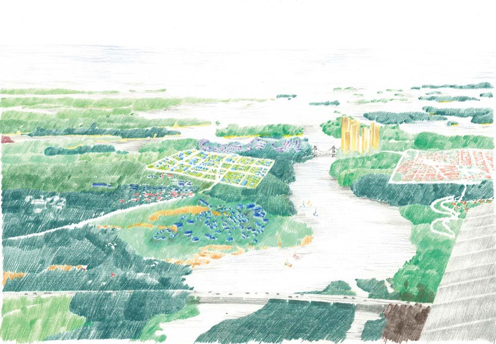
3 GREEN ANALOGUE RING OF LIFE RING The ring is the infrastructural spine for the new development. It carries with it a covered bike path, tram tracks, and necessary pipes and cables to service the districts-tobe along its route. In the early phases of development, this ring will be a scenic recreational route through the empty landscapes. Over time, as the districts are built, and it will service more and more people, it is improved: the bike path is covered, and eventually runs in a tunnel, the electric minimetrobus becomes a tram line, the summer ferry becomes a bridge TRAM The ring tram line is about10 km long, and takes about minutes to make a complete circle. It has initially fewer stops and faster service. As districts are built, and more stops established, the tram can operate both slow and express services. Also, if the amount of traffic starts hindering the service, a figure-8 tram service can be added to provide a more varied range of links, when tracks are added to cross Sipoonlahti along the Porvoo motorway bridge. INTERSECT & TANGENT The ring circumscribes Sipoonlahti, and touches regional public transport potentially at two points: the easternmost metro terminus intersects the ring at Hitå, and at Söderkulla, it tangents the future St. Petersburg rail connection and the regional trains operating along these tracks. Stations and timetables are designed to make transfers quick and pleasant. THE BRIDGE The new bridge over Sipoonlahti becomes the emblem for Sibbesborg. Before the bridge, there will be a lossi-ferry service. STREETS All road development seizes in the area. Only streets are developed within districts. All parking facilities for private cars are private, and are subject to a environmental property tax payable in Sibbesmarkka. A range of policies is implemented to encourage biking, car sharing and public transport. Söderkulla Söderkulla Metro Terminus E11 Porvoo Metro Terminus Skräddarby Kallbäck Current Situation: E11 runs to Porvoo to the east and connects to the current metro terminus at Mellunmäki to the west. In the near future to the Sakarinmäki terminus. First Ring Development Phase: a metrobus connection on the E11 to the metro terminus is established. A frequently and consistently operating bus loop consolidates the northern half of the ring. In addition to Söderkulla the transport connection points of Skräddarby and Hartwall become active areas of development. Söderkulla Söderkulla Lilläng Train Lilläng Joensuu Joensuu E11 Skräddarby Kallbäck E11 Skräddarby Kallbäck Nåran Nåran Norrskogen Norrskogen Nykärr Nykärr Metro Hitå Metro Hitå Vainudden Eriksnäs Vainudden Eriksnäs Phase 2: The bus transport ring is extended to the south connecting the future Sibbesborg metro terminus of Hitå. The ring is further developed to include an enclosedd bike tunnel enabling the year-round use of man s most efficient mode of transport. A number of new development zones areestablished along the 10 km long urban ring. As the metro starts to operate the metro bus service is reduced to a regular bus connection. Phase 3: The ring is fully developed into an efficient tram loop. The maximum travel time from any station to the metro connection at Hitå is less than 20 minutes. Later another regional rail connection tangents the ring at Söderkulla as the Helsinki - St. Petersburg is established. The bike tunnel and tram are equally popular modes of internal transport. 1:15000 THE CITY GAME 3/6
4 FIELDS OF ACTIVITY A RECIPE FOR PLURALITY FAR 0.7 SÖDERKULLA The Ring of Life connects a circular archipelago of diverse districts: towns, neighborhoods and villages, a collection of complementary urbanisms all within reach of nature, water and infrastructure. When all lots within a single district are built up, it can either be further condensed and infilled, or the development is directed to another new district established along the ring. DISTRICTS The tram stops are the centers of urban districts that vary in size, density and form. The districts have 2000 to 10,000 inhabitants, and their densities require and produce varied urban conditions. All development in the districts is within a 5-minute walking distance of the tram stop. Parks, forests, fields and shorelines are near to every location within the districts. Each district has its distinct and unique character and profile, interpreted through its plan, policy, services, qualities and features. HITÅ The largest, most populous and densest of the Sibbesborg s new districts, Hitå is the easternmost terminus for the Helsinki metro line, where passengers transfer to the ring trams. The district s planning is based on a mixed-use philosophy that intensifies the integration of living, working, shopping and leisure spaces. The architectural mix in Hitå is an eclectic, yet balanced blend of critical regionalism and global classics. The district s target population is and FAR 2. VAINUDDEN A bold variant of towers in the park, this district features high-rise buildings and a waterfront wind turbine park. The district s target population is 5000 and FAR is 2. ERIKSNÄS JOENSUU 5000 FAR 0.5 SKRÄDDARBY FAR 1 NORRSKOGEN 5000 FAR 0.5 HITÅ FAR 2 KALLBÄCK FAR 1 NÅRAN 5000 FAR 0.5 VAINUDDEN 5000 FAR 2 NYKÄRR FAR 0.5 ERIKSNÄS FAR 0.7 SÖDERKULLA The Söderkulla district is based on the present, multilayered and casual urbanism, but with careful insertions of new densities and infrastructures within its existing fabric. Major new developments include a regional rail link to Helsinki, with a fast connection to the Helsinki Vantaa Airport, and train services eastbound towards St. Petersburg. Söderkulla s target population is 20,000 inhabitants and district FAR (floor-area-ratio) is 0,7. JOENSUU The Joensuu wooden district is situated by the mouth of Sipoonjoki by the small boat harbor. Timber construction, passive solar power, on-site composting and biogas are the focus of the local building and energy policy. Joensuu s target population is 5000 inhabitants and district FAR is 0,5. SKRÄDDARBY The E11 motorway runs under Skräddarby, the leisure, retail and office district. Here are collected large buildings and programs: a hockey arena, a DIY-megastore, a medical centre, a conference center, a wellness spa and a low-security prison. The housing and services in Skräddarby are geared towards an elderly population, with an emphasis on assisted living and service apartments. The target population is inhabitants (incl. workin pop.). The district FAR is 1. NORRSKOGEN A futuristic waterfront district, Eriksnäs, is connected to Hitå and Vainudden by the new bridge. This district is known for its sail-boat harbours, water-bus tourists, fashion-conscious inhabitants, fish restaurants, cafés and shoreline promenades. Target population 10,000 inhabitants and FAR 0,7. NYKÄRR Nykärr district s urban plan is a strict mercantilist grid in the spirit of 18th century Finnish wooden towns. The building code favors toned-down classicism and timber construction. Nykärr is known for its slightly conservative, yet sophisticated atmosphere. Target population 10,000, FAR 0,5. NÅRAN Nårän will continue and complement the patchwork of developments in the area. The district s style is late 20th century realism. Target population 5000, FAR 0,5. KALLBÄCK The logistics and research campus of Kallbäck is one of the employment nodes of Sibbesborg. It is home for small and large businesses from diverse fields such as agribusiness, food, clean tech, energy research, education, distribution and storage. Target population (incl. workin pop.) 10,000, FAR 1. The Norrskogen district is characterized by the small-scale hilltop villages and lush green valleys. Each hilltop settlement has its own building code and architectural style. The focus of the district s building and energy policy are: geothermal energy, passive house-technology, photovoltaics and local smart-grids with a feed-in-tariff to the national grid. The district s target population is 5000 inhabitants and FAR is 0,5. 1:15000 Poor foundation areas Municipally owned land and cooperation areas THE CITY GAME 4/6


5 ARCHIPELAGO OF URBANISMS NORRSKOGEN, SKRÄDDARBY, VAINUDDEN 1: :2000 THE CITY GAME 5/6


6 GREETINGS FROM SIBBESBORG TERVEISIÄ SIBBESBORGISTA THE CITY GAME 6/6
7 THE CITY GAME Letʼs play a complete, comprehensive, ambitious and grand game, that will as a consequence create a new kind of urbanism: a lively city that responds to, and grows out of the needs and dreams of tomorrow. SCENARIO This proposal is a scenario, drafted by a team of players ready to act it out. Instead of a static result, we present a set of objectives, strategies and tools to inform an iterative, incremental process of city-making, a game of strategic urban skill with this vision as its opening form. Unlike regular games this one has no winners nor losers. Its sole aim is to keep on play- ing, and for us to get better at it together as we go along... To see and show what we can achieve: a new sustainable Finnish city containing potential for unforeseen urban diversities and lifestyles.
8 THE CITY GAME Letʼs play a complete, comprehensive, ambitious and grand game, that will as a consequence create a new kind of urbanism: a lively city that responds to, and grows out of the needs and dreams of tomorrow. SCENARIO This proposal is a scenario, drafted by a team of players ready to act it out. Instead of a static result, we present a set of objectives, strategies and tools to inform an iterative, incremental process of city-making, a game of strategic urban skill with this vision as its opening form. Unlike regular games this one has no winners nor losers. Its sole aim is to keep on play- ing, and for us to get better at it together as we go along... To see and show what we can achieve: a new sustainable Finnish city containing potential for unforeseen urban diversities and lifestyles. ECOLOGY, ECONOMY GREEN ANALOGUE The undeveloped areas of Sibbesborg are treated with equal importance and consideration as the built-up districts. Parallel to the planning and construction of the city - a long term process - takes place the shaping, gardening, planting and harvesting of the surrounding nature, one of Sibbesborgʼs key assets from the points of view of identity, ecosystems services, biodiversity, heritage and leisure.to ensure the cityʼs green counterpart is cared for, managed and valued, we suggest the following strategies and tools: BOUNDARIES Each urban districtʼs edge is clearly delineated and en- forced. The urban plans are made with this boundary, or city wall in mind, and will not extend beyond it at any point in time. All building activity outside boundaries is suspended. TRANSFER OF DEVELOPMENT RIGHTS The development rights of all the landowners in the Sibbesborg area are transferable to the districts. This way, the land ownership patterns of the area will not dictate urban geography and development. Different incentives (such as harvests of annual building right quotas or expiry dates) can be used to ramp up and channel development to the districts, projects and infrastructures that the city prioritizes. The transfer of development rights is a powerful tool to com- bat sprawl and uncontrolled urban patterns. SIBBESMARKKA Landuse patterns of Sibbesborg are evaluated from the point of view of their contribution towards preservation, ecosystems services, biodiversity and carbon balance. Stakeholders whose properties help reduce the overall environmental footprint of the city are granted a positive income of the local eco-currency, Sibbesmarkka. Accordingly, land uses and activities that burden the environment
9 result in a debt, that must be paid paid off with Smk, thus creating a market and demand for land to remain unbuilt. This local eco-economy may be expanded to also include performance-based building permits and audits in the new urban districts. Integrated and holistic carbon budgets inform building design, permit processes, and usage as well as land use and an active ecosystems landscape management of both public and private properties. TOWARDS A 2500W SOCIETY Sibbesborgʼs sustainability vision is based on the 2500W society model. The aim is to enable, encourage and usher the inhabitants of the city towards reducing the total annual energy budget of Sibbesborg to this level without compromising the standard of living. The 2500W model is the yardstick and chief sustainability indicator for energy policy, management of material flows and urban planning. By giving emphasis to local food and energy production, the city aims at drastic longterm reductions of fossil fuel use (i.e. local CHP-plants favor local renewable fuels such as energy reeds, wood chips and pellets). The Sibbesmarkka may be used to trade emission and energy quotas between households and businesses that perform differently. A SOLUTION SPECTRUM Although the sustainability goals are consistent throughout the city, Each district will develop its own policies and implementations that take into account its unique characteristics. The inhabitants and various stakeholders are invited to participate in creating new solutions and working models towards these goals. This range of local pilot projects and beta-preneurship that addresses issues of environmental, social and economic sustainability attracts a mosaic of subcultures, a community of amateurs, professionals, enthusiasts and entrepreneurs who are all engaged in making Sibbesborg better. Supporting and championing this culture of thinking and doing is essential for the cityʼs performance and identity as global forerunner in urban best practice. A CARBON BALANCE Sibbesborg will monitor its carbon footprint, and aim to reach carbon neutrality by the year By simultaneously reducing CO2 emissions and increasing renewable energy production and biocapacity, this goal is possible by extending beyond the city limits a policy of placing easements on areas with CO-equivalent biocapacity, remediating ecosystems services and restoring habitats and biodiversity.
10 RING OF LIFE RING The ring is the infrastructural spine for the new development. It carries with it a covered bike path, tram tracks, and necessary pipes and cables to service the districts-to- be along its route. In the early phases of development, this ring will be a scenic recreational route through the empty landscapes. Over time, as the districts are built, and it will service more and more people, it is improved: the bike path is covered, and eventually runs in a tunnel, the electric mini-metrobus becomes a tram line, the summer ferry becomes a bridge... TRAM The ring tram line is about10 km long, and takes about minutes to make a complete circle. It has initially fewer stops and faster service. As districts are built, and more stops established, the tram can operate both slow and ex- press services. Also, if the amount of traffic starts hindering the service, a figure-8 tram service can be added to pro- vide a more varied range of links, when tracks are added to cross Sipoonlahti along the Porvoo motorway bridge INTERSECT & TANGENT The ring circumscribes Sipoonlahti, and touches regional public transport potentially at two points: the easternmost metro terminus intersects the ring at Hitå, and at Söderkulla, it tangents the future St. Petersburg rail connection and the regional trains operating along these tracks. Stations and timetables are designed to make transfers quick and pleasant. THE BRIDGE The new bridge over Sipoonlahti becomes the emblem for Sibbesborg. Before the bridge, there will be a lossi-ferry service. STREETS All road development seizes in the area. Only streets are developed within districts. All parking facilities for private cars are private, and are subject to a environmental property tax payable in Sibbesmarkka. A range of policies is implemented to encourage biking, car sharing and public transport.
11 A RECIPE FOR PLURALITY ARCHIPELAGO OF URBANISMS The Ring of Life connects a circular archipelago of diverse districts: towns, neighborhoods and villages, a collection of complementary urbanisms all within reach of nature, water and infrastructure. When all lots within a single district are built up, it can either be further condensed and infilled, or the development is directed to another new district estab- lished along the ring. WALKABLE DISTRICTS All development in the districts is within a 5-minute walking distance of the tram stop. Parks, forests, fields and shore- lines are near to every location within the districts. DISTRICTS The tram stops are the centers of urban districts that vary in size, density and form. The districts have 2000 to 10,000 inhabitants, and their densities require and produce varied urban conditions. Each district has its distinct and unique character and profile, interpreted through its plan, policy, services, qualities and features. SÖDERKULLA The Söderkulla district is based on the present, multilayered and casual urbanism, but with careful insertions of new densities and infrastructures within its existing fabric. Major new developments include a regional rail link to Helsinki, with a fast connection to the Helsinki Vantaa Airport, and train services eastbound towards St. Petersburg. Söderkul- laʼs target population is 20,000 inhabitants and district FAR (floor-area-ratio) is 0,7. JOENSUU The Joensuu wooden district is situated by the mouth of Sipoonjoki by the small boat harbor. Timber construction, passive solar power, on-site composting and biogas are the focus of the local building and energy policy. Joensuuʼs tar- get population is 5000 inhabitants and district FAR is 0,5. SKRÄDDARBY The E11 motorway runs under Skräddarby, the leisure, re- tail and office district. Here are collected large buildings and programs: a hockey arena, a DIYmegastore, a medical centre, a conference center, a wellness spa and a low-security prison. The housing and services in Skräddarby are geared towards an elderly population, with an emphasis on assisted living and service apartments. The target popu- lation is inhabitants (incl. workin pop.). The district FAR is 1. NORRSKOGEN The Norrskogen district is characterized by the small-scale hilltop villages and lush green valleys. Each hilltop settlement has its own building code and architectural style. The focus of the districtʼs building and energy policy are: geothermal energy, passive house-technology, photovoltaics and local smart-grids with a feed-in-tariff to the national grid. The districtʼs target population is 5000 inhabitants and FAR is
12 0,5. HITÅ The largest, most populous and densest of the Sibbesborgʼs new districts, Hitå is the easternmost terminus for the Helsinki metro line, where passengers transfer to the ring trams. The districtʼs planning is based on a mixed-use philosophy that intensifies the integration of living, working, shopping and leisure spaces. The architectural mix in Hitå is an eclectic, yet balanced blend of critical regionalism and global classics. The districtʼs target population is and FAR 2. VAINUDDEN A bold variant of towers in the park, this district features high-rise buildings and a waterfront wind turbine park. The districtʼs target population is 5000 and FAR is 2. ERIKSNÄS A futuristic waterfront district, Eriksnäs, is connected to Hitå and Vainudden by the new bridge. This district is known for its sail-boat harbours, water-bus tourists, fashion-conscious inhabitants, fish restaurants, cafés and shoreline promenades. Target population 10,000 inhabitants and FAR 0,7. NYKÄRR Nykärr districtʼs urban plan is a strict mercantilist grid in the spirit of 18th century Finnish wooden towns. The building code favors toned-down classicism and timber construction. Nykärr is known for its slightly conservative, yet sophisticated atmosphere. Target population 10,000, FAR 0,5. NÅRAN Nårän will continue and complement the patchwork of developments in the area. The districtʼs style is late 20th century realism. Target population 5000, FAR 0,5. KALLBÄCK The logistics and research campus of Kallbäck is one of the employment nodes of Sibbesborg. It is home for small and large businesses from diverse fields such as agribusiness, food, clean tech, energy research, education, distribution and storage. Target population (incl. workin pop.) 10,000, FAR 1.
13 IMPLEMENTING THE CITY GAME The Sipoo Municipality assigns a special Sibbesborg task force to steer and assess the development and implementation of The CIty Game Urban fabric of Sibbesborg as it is today, implementation of ongoing Sipoo 2025 masterplans. Anticipation and adaptation of metropolitan rail links in the area s(hitå metro terminus or Eastbound regional rail tangent at Söderkulla). Delineation, survey and marking of the Ring around Sipoonlahti bay. Consolidation of the landscape strategy (Green Analogue) and definition of boundaries and target densities and populations for future urban districts Anticipation of the Hitå metro terminus builds up, as development commences at Hitå district (pioneer residential), Söderkulla and Nåran infills (residential), Kallbäck (clean tech campus). Establishing a temporary metrobus connection along the E11 from the metro terminus at Sakarinmäki along Ring to Hitå (see diagrams, panel 3). Re-evaluation and adaptation of the landscape strategy, district boundaries, densities and populations (metro service to Hitå, ring bus service established) Hitå district development accelerates when metro connection opened, Inauguration of the Sipoonlahti bay bridge, commencement of development at Nykärr and Skräddarby. Continuation of infill development at Nåran and Söderkulla. Commencement of construction Eastbound rational rail tangent. Hitå population mean energy consumption level 2850W with 45% local, renewables. Re-evaluation and adaptation of the landscape strategy, district boundaries, densities and populations (ring tram service opened) Norrskogen and Eriksnäs development commenced, Kallbäck manufacturing facilities go through refurbishments into small offices, Söderkulla new station construction begins, minor development ongoing in other districts. Re-evaluation and adaptation of the landscape strategy, district boundaries, densities and populations Ad infinitum, jeu permanent.
Sibbesborg: Competition for Sustainable Community Development
 Sibbesborg: Competition for Sustainable Community Development Pseudonym "Sibblings" Description The urban structure of Sibbesborg is based on a combination of several mutually connected centres. Each of
SIBBESBORG COMPETITION
 1/4 FOR SUSTAINABLE COMMUNITY DEVELOPMENT SIBBESBORG COMPETITION OVERALL PLAN 1:15000 Principles of the design and the path to realisation History reborn. The proposal is constructed on the history of
SIBBESBORG HEART AND SOUL THE REGION REGIONAL PLANS HELSINKI SISSESBORG PORVOO STRIATION OF THE LANDSCAPE. We were inspired by
 STRIATION OF THE LANDSCAPE We were inspired by * the extraordinary natural beauty of the PLACE with the striation of the landscape, * the PEOPLE s vision and commitment to democracy in action and * the
Sustainably Repositioning Greyfield Sites. Greyfield Sites Anywhere
 Sustainably Repositioning Greyfield Sites Jim Constantine Looney Ricks Kiss Architects Todd Poole 4ward Planning Greyfield Sites Anywhere Pennsylvania Chapter American Planning Association Conference 2009
Vancouver. Title of the Initiative. Initiative Duration. Submitted by. Comments by the Jury
 134 Vancouver Title of the Initiative Initiative Duration Submitted by Comments by the Jury Visionary Vancouver: Creating a Welcoming and Sustainable Place for All 2009-2020 Wendy Au, Deputy City Manager,
Plano Tomorrow Vision and Policies
 Plano Tomorrow Vision and Policies PLANO TOMORROW PILLARS The Built Environment The Social Environment The Natural Environment The Economic Environment Land Use and Urban Design Transportation Housing
4 Sustainability and Growth Management
 4 Sustainability and Growth Management Introduction Traditionally, has assumed growth and development with limited consideration for the long-term negative social, environmental or economic impacts on
City of Kingston. North King s Town Secondary Plan Open House + Workshop #1 February 28, 2018
 City of Kingston North King s Town Secondary Plan Open House + Workshop #1 February 28, 2018 1 event agenda 30 min Panel Review + Discussion 30 min Presentation + Q&A 75 min Workshop Session 15 min Report
CHONGMING ISLAND SHANGHAI CENTRAL CITY
 Chongming Island CHONGMING ISLAND SHANGHAI CENTRAL CITY Chongming Island Shanghai, China THE VISION: A GREEN ISLAND Chongming Island benefits from a magnificent setting, adjacency to the vibrant center
A Growing Community Rural Settlement Areas
 Town of Huntsville Official Plan Review - POLICY BACKGROUND PAPER A Growing Community Rural Settlement Areas BACKGROUND: In addition to the fully municipally-serviced Urban Settlement Area and the Hidden
12.2 CONCEPT DEVELOPMENT
 12 12.0 Final Concept Plan & Development Scenarios 12-1 12.1. Introduction 12-1 12.2. Concept Development 12-1 12.3. Concept Evaluation 12-2 12.4. Development Scenarios 12-2 12.1 INTRODUCTION Though the
PLAN ELEMENTS WORKSHOP. April 5, 2016
 PLAN ELEMENTS WORKSHOP April 5, 2016 needs more housing. But there is no one-size fits-all solution. Every neighborhood has its own character. In some places, density is not only appropriate it is badly
1Planning. Approach. Part I Chapter 1: Planning Approach
 1Planning Approach Part I Chapter 1: Planning Approach 1 Planning Approach page 5 1Planning Approach The preparation of the Master Plan constitutes a unique opportunity to reflect collectively on the
Municipal Plan*Assessment
 Municipal Plan*Assessment This tool was developed to assist in reviewing municipal master plans and in determining if these plans are consistent with smart growth principles, neighboring municipal plans,
OUR GREATER SYDNEY A metropolis of three cities. OVERVIEW. connecting people. DRAFT Greater Sydney Region Plan
 OUR GREATER SYDNEY 2056. A metropolis of three cities. OVERVIEW. connecting people. DRAFT Greater Sydney Region Plan October 2017 This document is an overview of the draft Greater Sydney Region Plan. To
SALISBURY TOMORROW Our Vision
 SALISBURY TOMORROW Our Vision Salisbury is committed to supporting a high quality of life and sense of community for all residents. These commitments need to be reflected in our community programs, services
WATERLOO STATE SIGNIFICANT PRECINCT SUMMARY OF STUDIES
 WATERLOO STATE SIGNIFICANT PRECINCT SUMMARY OF STUDIES Technical studies will be undertaken to inform the master planning process for the Waterloo precinct to develop a Precinct Proposal to redevelop the
NEW REGIONAL OFFICIAL PLAN HIGH LEVEL PROCESS & FRAMEWORK
 NEW REGIONAL OFFICIAL PLAN HIGH LEVEL PROCESS & FRAMEWORK Why A New Official Plan Originally the role of Regionally Planning and content of Regional Official Plan (1970s) primarily focused on protecting
City of St. Thomas New Official Plan
 City of St. Thomas New Official Plan Sustainable & Healthy Community Workshop Ann Joyner and Paddy Kennedy Dillon Consulting Limited Work Shop Outline Introduction Presentation Exercise 1 (individual)
CHAPTER 7: Transportation, Mobility and Circulation
 AGLE AREA COMMUNITY Plan CHAPTER 7 CHAPTER 7: Transportation, Mobility and Circulation Transportation, Mobility and Circulation The purpose of the Transportation, Mobility and Circulation Chapter is to
Cumberland Region Tomorrow is a private, non-profit, citizen based regional organization working with Greater Nashville Regional Council
 Cumberland Region Tomorrow is a private, non-profit, citizen based regional organization working with Greater Nashville Regional Council and others in the public and private sectors, dedicated to planning
Building Better Cities Pyrmont
 Building Better Cities Pyrmont 1 Building Better Cities A fieldwork program for the Stage 6 Geography Urban Places topic focussing on:! Pyrmont - a case study of an inner city suburb undergoing change
CHAPTER 1 Introduction
 CHAPTER 1 Introduction From sea to summit, Lane County covers almost 4,800 square miles of diverse Oregon landscape. Stretching from the Pacific Ocean through the Coastal Range, the Willamette Valley to
Pioneering the Sustainable Future of Pakistan. A New Destination of Islamabad
 Pioneering the Sustainable Future of Pakistan A New Destination of Islamabad A New Destination of Islamabad C A P I TAL S M A R T CIT Y ISL A M A B A D, PAKISTA N CAPITAL SMART CITY ISLAMABAD C A P I TAL
THE POLICY FRAMEWORK FOR WALKABLE COMMUNITIES. Community Technical Assistance Program Building Active Communities Institute March 2016
 THE POLICY FRAMEWORK FOR WALKABLE COMMUNITIES Community Technical Assistance Program Building Active Communities Institute March 2016 ACTIVE COMMUNITIES BACK THEN ACTIVE COMMUNITIES BACK THEN Lifestyle
Nader Obied Abd al raheem hathat. Dr. Farid S. Al-Qeeq
 Submit from Nader Obied Abd al raheem hathat Submit to Dr. Farid S. Al-Qeeq DEC. 2010 NEW URBANISM : is the most important planning movement this century, which emerged during the late 1980s and early
New Auburn Village Center Study Auburn, Maine
 Auburn, Maine Option Review Summary Prepared for: Androscoggin Transportation Resource Center and City of Auburn Prepared by: T.Y. Lin International MRLD October 10, 2013 1. Introduction This memo summarizes
Keystone Business Park Precinct Structure Plan North East Industrial Precinct. Part 2 Design Principles
 Keystone Business Park Precinct Structure Plan North East Industrial Precinct Part 2 Design Principles Context Issues Services Landform Issues Geotech and contamination Ecology Traffic and access Issues
Inspiring Technovation
 1 2 Table of content List of table and figures... Executive summary... 1. Introduction... 2. Material and methods... 3. Results... 3.1 Today s facts about Versailles: a diagnostic approach... 3.1 Vision
University of the District of Columbia Van Ness Campus Master Plan Community Open House 3. December 8, 2010
 University of the District of Columbia Van Ness Campus Master Plan Open House 3 December 8, 2010 Introductions Sequence of Work: Campus Master Plan BEGIN: INTRODUCE AND START WORK Project Initiation Team
Tāhuhu whakaruruhau ā-taone The sheltering ridge pole
 B2. Tāhuhu whakaruruhau ā-taone - Urban growth and form B2.1. Issues Tāhuhu whakaruruhau ā-taone The sheltering ridge pole Auckland s growing population increases demand for housing, employment, business,
greenprint midtown SUSTAINABILITY ACTION PLAN 2012
 greenprint midtown SUSTAINABILITY ACTION PLAN 2012 MIDTOWN ALLIANCE SOUTHFACE ENERGY INSTITUTE RENAISSANCE PLANNING GROUP SUSTAINABLE ATLANTA PERKINS+WILL 2 GREENPRINT MIDTOWN 1. Introduction Sustainability
Whitemarsh Comprehensive Plan Update: Housing & Land Use. Public Workshop #3: September 20, 2018
 Whitemarsh Comprehensive Plan Update: Housing & Land Use Public Workshop #3: September 20, 2018 Agenda Welcome Process Recap What We ve Heard The Plan Framework Review of Recommended Actions Land Use Housing
Community Design Guidelines. Port Wallace DRAFT
 Community Design Guidelines Port Wallace DRAFT Energy 1 2 3 Nature Movement Connections Built Form DRAFT Layout Energy 1 Nature Community Design Guidelines GREAT COMMUNITIES PROTECT, CELEBRATE, AND CONSERVE
Create Policy Options Draft Plan Plan Approval. Public Consultation Events. Phase 2
 Background Grandview-Woodland Community Plan In the spring of 2012, the City of Vancouver embarked on a comprehensive community planning program in the Grandview-Woodland neighbourhood. The process has
SQUAMISH 2010 AND BEYOND COMMUNITY VISION
 Our plan has been imagined and created to be both pragmatic and visionary. At the core of the strategy is a consideration of the highway s role and its impact on the community. First and foremost in creating
Euston Area Plan - Examination: Statement in response to the Inspector s Matters, Issues and Questions
 1 Euston Area Plan - Examination: Statement in response to the Inspector s Matters, Issues and Questions Sydney and London Properties Limited June 2014 2 3 This document is the Statement in response to
Northern Territory Compact Urban Growth Policy
 Northern Territory Compact Urban Growth Policy A Reference Policy Document to clause 2.7 (Reference to Policy) of the NT Planning Scheme May 2015 Table of Contents 1 Policy Setting... 3 1.1 Context for
Robbinsdale LRT Station. CDI Development Guidelines. August Overview
 Robbinsdale LRT Station August 2018 Overview The City of Robbinsdale may have the coolest opportunity site along the 13 mile stretch of the Bottineau LRT corridor / Blue Line extension. Located a block
DALY CITY VISIONING PROCESS COMMUNITY WORKSHOP 3 MAY 8, 2008
 DALY CITY VISIONING PROCESS COMMUNITY WORKSHOP 3 MAY 8, 2008 PROCESS General Plan - a statement of the community s values, vision and aspirations for now and into the future... Timeframe LONG TERM - 2030
DRAFT GREATER SYDNEY REGION PLAN OBJECTIVES, STRATEGIES AND ACTIONS
 Greater Sydney Commission DRAFT GREATER SYDNEY REGION PLAN OBJECTIVES, STRATEGIES AND ACTIONS Issued: 26 OCTOBER 2017 Version: 1 Subject: Greater Sydney Region and District Plans This information note
Draft Western District Plan
 Powered by TCPDF (www.tcpdf.org) Draft Western District Plan Submission_id: 31440 Date of Lodgment: 15 Dec 2017 Origin of Submission: Online Organisation name: Goodman Property Services Australia Pty Ltd
Living in Albemarle County s Urban Places
 Living in Albemarle County s Urban Places ALBEMARLE COUNTY, VIRGINIA A Closer Look at Albemarle s Approach to Managing Growth and Creating Quality Urban Environments www.albemarle.org Page 2 Living in
Municipal Development Plan Update Urban Service Area and Hamlets
 ENCLOSURE 1 Municipal Development Plan Update Urban Service Area and Hamlets Priorities Committee January 24, 2017 MUNICIPAL DEVELOPMENT PLAN UPDATE SHAPING OUR FUTURE MDP Update - Agenda MDP Update Public
City Introduction & Context
 City Introduction & Context Indicator Units Year of data Population 547733 Inhabitants 2011 Area 84.9 km 2 2014 Population Density 5090 Inh/km 2 2014 GDP 22800 /Capita 2014 Köppen climate classification
DOMINION BOULEVARD CORRIDOR STUDY AND ECONOMIC DEVELOPMENT STRATEGIC PLAN A MODEL FOR CHESAPEAKE S FUTURE
 DOMINION BOULEVARD CORRIDOR STUDY AND ECONOMIC DEVELOPMENT STRATEGIC PLAN A MODEL FOR CHESAPEAKE S FUTURE Overview I. Draft Plan Process II. Draft Plan Overview a. Market Analysis b. Master Land Use Plan
South District What we heard
 What we heard Vision to 2056 and Priorities Governance and implementation Infrastructure and funding Feedback supported: The vision for a metropolis of three cities, but emphasised the importance of infrastructure
Implementation Guide Comprehensive Plan City of Allen
 Implementation Guide 2030 Comprehensive Plan City of Allen DRAFT 2015 Implementation Guide Allen 2030 Comprehensive Plan INTRODUCTION The Comprehensive Plan serves as a guide for the growth and development
Transforming Saint John s Urban Heart -
 Transforming Saint John s Urban Heart - How Innovative Community Engagement Inspires a Bold Municipal Plan for a More Sustainable and Compact Saint John 2012 NNECAPA Conference - Brunswick, ME October
REQUEST FOR QUALIFICATIONS
 REQUEST FOR QUALIFICATIONS VILLAGE OF HAMBURG COMPREHENSIVE ZONING/LAND USE REGULATIONS UPDATE Prepared By: Village of Hamburg 100 Main Street Hamburg, New York 14075 Village of Hamburg RFQ Page 1 of 10
OUR JOBS Innisfil Heights Strategic Settlement Employment Area Planning Policy Update. Council Workshop April 22, 2015
 Innisfil Heights Strategic Settlement Employment Area Planning Policy Update Council Workshop April 22, 2015 Study Objectives Support the Economy pillar of Inspiring Innisfil 2020 Strategically position
MAYFIELD WEST SECONDARY PLAN PHASE 2
 MAYFIELD WEST SECONDARY PLAN PHASE 2 Public Open House #3 February 25, 2010 Draft Preferred Land Use Scenario TOWN OF CALEDON PLANNING & DEVELOPMENT DEPARTMENT Open House Agenda TOWN OF CALEDON 1. Welcome
Strategic revitalization of polluted bay area into new citizens park
 2015 Strategic revitalization of polluted bay area into new citizens park The project transforms Töölönlahti, a polluted bay area currently dividing Helsinki s centre in two, into an attractive green heart
milano santa giulia Our Project, Your Retail
 milano santa giulia Our Project, Your 2 A new city district for a global city population density 3 Milan is the most populous city in Italy and the country s main industrial, financial and commercial centre,
Parks Master Plan Implementation: Phase I Waterfront Use and Design REPORT #: September 7, 2016 File #
 0 'O DI Lan-171-14 1 - THE CORPORATION OF THE TOWN OF COBOURG..,. STAFF REPORT TO: FROM: Mayor and Members of Council Dean A. Hustwick, Director of Recreation and Culture DATE OF MEETING: Committee of
Plan Modification to Chapter B2 of the Auckland Unitary Plan(AUP) Operative in part (15 November 2016)
 Operative in part (15 November 2016)") UNITARY PLAN UPDATE REQUEST MEMORANDUM TO FROM Phill Reid Linley Wilkinson DATE 25 September 2018 SUBJECT Plan Modification to Chapter B2 of the Auckland Unitary Plan(AUP) Operative in part (15 November
UNITARY PLAN UPDATE REQUEST MEMORANDUM TO FROM Phill Reid Linley Wilkinson DATE 25 September 2018 SUBJECT Plan Modification to Chapter B2 of the Auckland Unitary Plan(AUP) Operative in part (15 November
SAN RAFAEL GENERAL PLAN 2040 INTRODUCTION AND OVERVIEW
 SAN RAFAEL GENERAL PLAN 2040 INTRODUCTION AND OVERVIEW Steering Committee Presentation February 14, 2018 Purpose of General Plan Guide land use and development decisions Coordinate transportation, infrastructure,
RE-Imagining the Downtown Colorado Springs Master Plan
 RE-Imagining the Downtown Colorado Springs Master Plan 2016 APA Colorado State Conference October 25, 2016 Overview 8:00 Welcome, Introductions, and Overview 8:15 Downtown s Planning History 8:30 A Market
DRAFT WESTERN CITY DISTRICT PLAN PLANNING PRIORITIES AND ACTIONS
 Greater Sydney Commission DRAFT WESTERN CITY DISTRICT PLAN PLANNING PRIORITIES AND ACTIONS Issued: 26 OCTOBER 2017 Version: 1 Subject: Greater Sydney Region and District Plans This information note is
Selected Area Study. Vision Plan Draft
 East Polk County Selected Area Study Draft 10.30.08 Contents Guiding Principles...4 Context Conclusions...5 Current Context...8 Scenarios...9 Scenario: Status Quo...10 Scenario: Connected & Directed Growth...12
Lynn Waterfront Master Plan
 Lynn Waterfront Master Plan Public Meeting #2 December 10th, 2018 1 Project Schedule Update September 26, 2018 December 10, 2018 Development of the Master Harbor Plan Amendment and Revised Waterfront Master
Wooden Urban Villages
 Wooden Urban Villages K. Kuismanen 1 Wooden Urban Villages Kimmo Kuismanen Dr. Tech., architect-safa, CASE consult Ltd FI-Oulu 2 Wooden Urban Villages K. Kuismanen 18. Internationales Holzbau-Forum 2012
Village of Fair Haven Goals & Objectives
 Village of Fair Haven Goals & Objectives 1 Natural Environmental Quality & Aesthetics Embrace policies and programs that preserve and enhance the Village s natural resources, environment, water quality,
North District What we heard
 What we heard Vision to 2056 and Priorities Governance and implementation Infrastructure and funding The vision for a metropolis of three cities, and the 30 minute city. Feedback emphasised: That for the
The Five Components of the McLoughlin Area Plan
 The Five Components of the McLoughlin Area Plan This documents contains the complete language of the five components of the McLoughlin Area Plan: The Vision Statement The Values The Guiding Principles
CITY OF UNION CITY MINUTES GENERAL PLAN ADVISORY COMMITTEE
 CITY OF UNION CITY MINUTES GENERAL PLAN ADVISORY COMMITTEE WEDNESDAY, MARCH 4, 2015, 6:30 P.M. IN THE CITY COUNCIL CONFERENCE ROOM OF CITY HALL 34009 ALVARADO-NILES BLVD., UNION CITY, CALIFORNIA Attachment
The University District envisions, in its neighborhood
 Envisioning the University District Link Light Rail in Seattle s neighborhoods CIY OF SEALE CONCEP-LEVEL SAION AREA PLANNING RECOMMENDAION RESOLUION # 30165 EXHIBI L Vision 08.2000 he University District
CHAPTER 6: Community Design and Appearance
 AGLE AREA COMMUNITY Plan CHAPTER 6 CHAPTER 6: Community Design and Appearance Community Design and Appearance How a community is designed and what a community looks like are attributes fundamental to the
2040 LUP is a part of the Comprehensive Plan and carries the same legal authority. Economic Challenges
 1.1. Guiding Anchorage s Growth Where will new residents settle over the next two decades? Where will people work, shop, and play? Will there be enough room to grow? How will Anchorage look? Will growth
Draft Eastern District Plan
 Draft Eastern District Plan Submission_id: 31238 Date of Lodgment: 13 Dec 2017 Origin of Submission: Online Organisation name: Turrulla Gardens Pty Ltd C/- Mecone Organisation type: Industry First name:
10.0 Open Space and Public Realm
 10.0 Open Space and Public Realm 10.0 Open Space and Public Realm The Public Open Space System is comprised of: outdoor spaces available for public use that are either publicly owned (e.g., parks and
Port Lavaca Future Land Use
 Port Lavaca Future Land Use Introduction The City of Port Lavaca is beginning to see sustained growth, after many years of relative stable population. New single family homes, apartments, and businesses
EXHIBIT A. Tax Increment Reinvestment Zone No. 1 (Town Center) First Amended Project Plan 1
 First Amended Project Plan 1") EXHIBIT A Tax Increment Reinvestment Zone No. 1 (Town Center) First Amended Project Plan 1 1 As amended by Resolution No. 2008-02-001(TR1R) of the Tax Increment Reinvestment Zone No.1, and approved to
EXHIBIT A Tax Increment Reinvestment Zone No. 1 (Town Center) First Amended Project Plan 1 1 As amended by Resolution No. 2008-02-001(TR1R) of the Tax Increment Reinvestment Zone No.1, and approved to
Please read the entire document
 projects impacting the waterfront revitalization area. The waterfront revitalization area of the town will have to subareas to the west and east of the village. Page 6 of 6 Wayfinding master plan create
Mississippi Skyway Preliminary Engineering Report
 EXECUTIVE SUMMARY Mississippi Skyway Preliminary Engineering Report CITY OF RAMSEY, MINNESOTA DECEMBER 2014 City of RAMSEY EXECUTIVE SUMMARY Project Need and Intent The Mississippi Skyway pedestrian bridge
Australia s Major New TOD Urban Growth Corridors
 Australia s Major New TOD Urban Growth Corridors Evan Jones Brookfield Multiplex Chair Australian Council for New Urbanism The Views Expressed are solely those of the Author ACNU 28 April 2010 Making livable
The London 2012 Olympic Park and Green Network Legacy
 2012 Central Scotland Green Network Forum How Green Networks make our Towns and Cities Livable The London 2012 Olympic Park and Green Network Legacy Neil Mattinson Senior Partner LDA Design The Story Begins.
Enriching co-operation and promoting sustainable travel in the Helsinki Region: Helsinki Region Transport System Plan HLJ 2015
 Enriching co-operation and promoting sustainable travel in the Helsinki Region: Helsinki Region Transport System Plan HLJ 2015 3rd European Conference on Sustainable Urban Mobility Plans 12-13 April 2016
Making the case for Sustainable Transport Project Potential
 Making the case for Sustainable Transport Project Potential The Structural Investment Fund (SIF) Strategy for Greater Lincolnshire identifies the barriers to growth identified by having poor transport
What s in a Name Sustainability, Smart Growth, New Urbanism
 What s in a Name Sustainability, Smart Growth, New Urbanism Published in the Summer 2011 Issue of APA s The Commissioner Pete Pointner FAICP Planning commissioners frequently hear abstract terms bantered
Our City Centre is a vibrant, creative and welcoming destination, with a modern business, cultural, shopping, leisure and residential offer
 3. Sheffield in 2034 Our City sits at the heart of a strong, distinctive and internationally successful City Region economy which supports innovation and enterprise Our City Centre is a vibrant, creative
Sub-committee on Harbour Plan Review of Harbour-front Enhancement Committee. Ninth Meeting
 Sub-committee on Harbour Plan Review of Harbour-front Enhancement Committee Ninth Meeting Date: 5 October 2005 Time: 3:30pm Venue: Conference Room 15/F, North Point Government Offices, 333 Java Road, North
PORT WHITBY COMMUNITY
 PORT WHITBY COMMUNITY SECONDARY PLAN UPDATE COMMUNITY IMPROVEMENT PLAN URBAN DESIGN GUIDELINES September 2015 DRAFT PROPOSED AMENDMENT NUMBER # to the Whitby Official Plan PURPOSE: The intent of this Amendment
2A District-wide Policies
 2A Introduction This Chapter contains policies which are relevant to subdivision, use and development activities occurring across all zones and areas of the District. The policies in this Chapter implement
I615. Westgate Precinct
 I615. Westgate Precinct I615.1. Precinct Description The Westgate Precinct is located approximately 18km west of the Auckland city centre. There are seven Sub-precincts in the Westgate Precinct: Sub-precinct
Welcome to our exhibition
 Welcome to our exhibition housing development A46 Wildmoor Alcester Road Canal Quarter A422 Town Centre housing development Warwickshire-based IM Properties, one of the UK s largest privately owned property
Former Rockcliffe Airbase Community Design Plan Guiding Design Vision and Principles December 4, 2013
 APPENDIX 5 - Guiding Design Vision and Principles Former Rockcliffe Airbase Community Design Plan Guiding Design Vision and Principles December 4, 2013 Vision Statement The redevelopment of the former
Laberge Group. Town of Coeymans. Draft Comprehensive Plan. Overview of Planning Process
 Draft : Presentation of Goals & Strategies Laberge Group Benjamin H. Syden, A.I.C.P., E.D.P Director in Charge Nicole Allen, A.I.C.P. Senior Planner Anjali Malhotra Planner Presentation Outline Introductions
Murphy Crossing Site Redevelopment Community Engagement Meeting September 19, 2016
 Murphy Crossing Site Redevelopment Community Engagement Meeting September 19, 2016 SUMMARY 1 EXECUTIVE SUMMARY STATEMENT OF PURPOSE ABI has conducted a detailed study of 1. Market potential 2. Building
DAREBIN PLANNING SCHEME AMENDMENT C137
 Who is the planning authority? Planning and Environment Act 1987 DAREBIN PLANNING SCHEME AMENDMENT C137 EXPLANATORY REPORT This amendment has been prepared by the Darebin City Council, who is the planning
Elliot Park 2. Neighborhood Master Plan. Historical Perspective
 Elliot Park 2 Neighborhood Master Plan Historical Perspective August 2002 Early History Development patterns and the growth of Minneapolis largely grew out of the city s historical response to its geography.
UDF PLANS AND GUIDELINES
 UDF PLANS AND GUIDELINES 5 Land Use Land Use Development Plan Plan no. 3 Land Use Development Mixed Use Retail / Leisure Residential Civic and Institutional Proposed Zoning Table Development Edges Plan
OUR AREA SECTION 02 I NEXT PAGE. 2.1 This section sets the scene in regard to the role of the Legacy Corporation and the baseline
 7 ADOPTED LOCAL PLAN SECTION 02 2.1 This section sets the scene in regard to the role of the Legacy Corporation and the baseline position of the Local Plan. It sets out the historical context and current
Valuing Historic Places
 Valuing Historic Places Introduction Historic buildings and places have played an increasingly central role in the delivery of a range of public benefits, including education, economic development, sustainable
TREASURE ISLAND PHASE ONE PROJECTS PUBLIC ART PROJECT OUTLINE
 TREASURE ISLAND PHASE ONE PROJECTS PUBLIC ART PROJECT OUTLINE BACKGROUND (DEVELOPMENT PROJECT OVERVIEW) The Treasure Island Development is an approved 405-acre redevelopment project on Treasure Island
St. Anthony Park Community Council 10-year Planning Community Forum
 St. Anthony Park Community Council 10-year Planning Community Forum Introductions: Who are we? North SAP (North of Energy Park) South SAP (South of Energy Park) Introductions: Who are we? Live Play Work
Sahuarita District & Phase 1 Master Plan. Town Council December 11, 2017
 Sahuarita District & Phase 1 Master Plan Town Council December 11, 2017 Visioning Study Visioning Process Advisory Group Meetings Community Questionnaire Town Center Case Studies Community Analysis The
Official Plan Review
 Official Plan Review Summary Report - The Built Environment August 2014 Part 1: Introduction Planning for a healthy, prosperous and sustainable community is an important goal for our municipality. From
Cardiff International Sports Village Waterfront Development Volume IV : Non-Technical Summary of the Environmental Statement
 Greenbank Partnerships Ltd October 2012 Cardiff International Sports Village Waterfront Development Volume IV : Non-Technical Summary of the Environmental Statement Environmental Statement - Non Technical
Local Development Plan for Glasgow
 Local Development Plan for Glasgow Forbes Barron Head of Planning & Building Control Services Context and Process for LDP NPF 3 Principles An 80% reduction in emissions by 2050. Achieving the aims of the