CLACKAMAS COUNTY BOARD OF COMMISSIONERS 2051 Kaen Road, Oregon City BCC Hearing Room - 4th Floor. LAND USE HEARING October 3, :30 AM
|
|
|
- Oliver Knight
- 5 years ago
- Views:
Transcription
1 CLACKAMAS COUNTY PLANNING AND ZONING DIVISION DEPARTMENT OF TRANSPORTATION AND DEVELOPMENT DEVELOPMENT SERVICES BUILDING 150 BEAVERCREEK ROAD OREGON CITY, OR CLACKAMAS COUNTY BOARD OF COMMISSIONERS 2051 Kaen Road, Oregon City BCC Hearing Room - 4th Floor LAND USE HEARING October 3, :30 AM The item will not begin before time noted. Interested parties may appear and be heard during the testimony phase of any hearing at the above address. If a hearing is set for decision only, the evidence phase has been completed, so interested parties may no longer be heard. Applications or comments may be inspected, and calls or correspondence directed to: Planning & Zoning Division, 150 Beavercreek Road, Oregon City, OR 97045, (503) HEARING File No.: ZDO-270: TSP Minor Amendments Applicants: Clackamas County Proposal: ZDO-270 proposes three amendments to the Figures, Maps and Tables associated with the Clackamas County Comprehensive Plan, Chapter 5, Transportation System Plan. There are no text changes to the Comprehensive Plan or the Zoning Development Ordinance proposed. The changes to these Figures, Maps and Tables are necessary to maintain consistency between the Comprehensive Plan and current county practice, but none of the changes represent a substantive policy change. Staff Contact: Stephen Williams, Principal Transportation Planner, , SWilliams@clackamas.us
2 Planning & Zoning Development Services Building 150 Beavercreek Road Oregon City, OR Phone: (503) Fax: (503) Web: Land Use Hearing Item Staff Report to the Board of County Commissioners File Number: ZDO-270, Updates to Figures, Maps and Tables for Comprehensive Plan Chapter 5, Transportation System Plan Staff Contact: Stephen Williams, Principal Transportation Planner ( ); Long Range Planning Program Board of County Commissioners Hearing Date: October 3, 2018 PROPOSAL: ZDO-270 proposes three amendments to the Figures, Maps and Tables associated with the Clackamas County Comprehensive Plan, Chapter 5, Transportation System Plan. There are no text changes to the Comprehensive Plan or the Zoning Development Ordinance proposed. The changes to these Figures, Maps and Tables are necessary to maintain consistency between the Comprehensive Plan and current county practice, but none of the changes represent a substantive policy change. Background: The Transportation System Plan is included as Chapter 5 in the County s Comprehensive Plan. The Transportation System Plan (TSP) includes by reference a number of figures, maps and subsidiary plans that apply to specific transportation facilities or areas of the county. ZDO-270 proposes changes to several of the subsidiary elements that are incorporated in the Transportation System Plan by reference but does not propose any changes to the text or policies in the TSP. Proposed Amendments: Amendment #1: Modify Figures 5-1 a-f Urban Cross Sections, and Figures 5-2 a-f Rural Cross Sections Clackamas County has incorporated the Transportation System Plan into the Comprehensive Plan to improve the integration between land use policy and transportation policy. The urban and rural roadway cross sections are one of the important links in the plan between land use policy and transportation policy. The cross sections depict the county standard for the arrangement of traffic lanes, median, shoulder, bike lanes, curb/stormwater facilities, landscaping and pedestrian facilities on each roadway functional class. These cross-sections ZDO-270 BCC Staff Report Page 1 of 5 Hearing Date: 10/3/18
3 inform property owners of the standard transportation facilities that are required for each type of street frontage. The cross-sections also inform the designers and builders of streets of the types of street improvements that are required. The cross-sections are organized by functional classification, with urban cross sections for major arterials, minor arterials, collectors, local streets and urban alleys, and rural cross sections for arterials, rural arterials in unincorporated communities, rural collectors, rural collectors in unincorporated communities, and rural connectors/local streets. The proposed revisions bring the county cross section into conformance with national and regional standards and also existing county practice. Attached are the proposed revised urban and rural cross sections for all functional classifications, with the proposed changes highlighted. The proposed changes can be summarized as follows: Minimum back of sidewalk landscape has been set to 6 inches in all cases Addition of 6 inches for curb to the landscape strip/curb, allowing a full 5 foot landscape strip The term optional has been changes to the less ambiguous term as needed In some cases the bikeway width ranges are proposed to be changed to be consistent with national and regional standards and improve bicyclist safety Added flexibility in the requirements for gravel shoulder width and ditch width on the rural cross sections to better accommodate the wide variety of needs and existing situations Updated the identified paved width and ROW width to account for the other changes Amendment #2: Modify Appendix A.7 SE 172 nd Avenue/190 th Drive Corridor Management Plan The SE 172 nd /190 th Drive Corridor Management Plan was jointly created and adopted by Clackamas County and City of Happy Valley. It is intended to be the main north-south spine of a well-connected, multi-modal transportation system that will meet travel demands for all modes to the year 2035 as well as addressing congestion and safety problems in the corridor. The SE 172 nd /190 th Drive Corridor Management Plan was adopted by Clackamas County in February 2012 and added to the Comprehensive Plan Appendix A as a document adopted by reference. Earlier this year the county staff and City of Happy Valley worked with the original project consultant to make very minor revisions to the Corridor Management Plan. County staff was engaged throughout the process, and ensured that none of the revisions affected county plans or regulations. However, since the Corridor Management Plan was adopted by the county as part of the TSP, the county must adopt the revisions. There were five minor revisions as follows: a. Overview Figure 7-2E Added The adopted version of the Corridor Management Plan did not include an overview figure providing a broad view of the full extent of the plan ZDO-270 BCC Staff Report Page 2 of 5 Hearing Date: 10/3/18
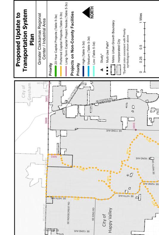
4 provisions. The Happy Valley revision added Figure 7-2E, which provides an overview of the plan (attached). b. Revisions to Figures 7-1A, 7-1B, 7-2A through 7-2D, and 7-3A In the revision process county staff asked that the roadway cross sections that include a cycle track be changed to place the cycle track behind the landscape strip, rather than immediately adjacent to the roadway surface. This changes avoids a maintenance problem and also improves safety. c. Update Pagination and Table of Contents The addition of Figure 7-2E added a page to the document, requiring that the pagination and table of contents be changed to conform. d. Add City of Happy Valley Logo In the adopted version the City of Happy Valley Logo was not included because the roadway was east of the city limits at that time. The revisions added the City of Happy Valley Logo alongside the County logo on the cover page and all the figures. e. Revise Adoption Date Revise the adoption date to January 2018 on the cover and all pages to reflect the date of the updated version. Amendment #3: Modify Table 5-3c Long Term Capital Projects Project #3029 Chapter 5 of the Comprehensive Plan, the Transportation System Plan, includes four tables of projects: Table 5-3a, 20 Year Capital Projects; Table 5-3b, Preferred Projects; Table 5-3c, Long Term Capital Projects; Table 5-3d, Regional Capital Projects. The 20 Year Capital Projects is the list of needed transportation projects that can reasonably be undertaken over the next 20 years given the current estimates of available funding. The Preferred Capital Projects is a list of needed, transportation projects that the County would undertake if additional funding becomes available. The remainder of the needed transportation projects are included in the Long Term Capital Projects List, which are not expected to be funded or constructed unless specific funding becomes available. The third revision to the Transportation System Plan that is proposed as part of this amendment is to divide a single Long Term Capital Project into two sections to allow a portion of the project to be built by a project applicant. The project proposed to be modified is #3029, which is named the West 82 nd Ave Parallel Road, extends from King Road to Luther Road and is described as follows: Construct collector road parallel to OR213 with bikeways and pedestrian facilities. As described in the TSP, project #3029 will extend 79 th Ave to create a continuous street between Luther Road and King Road for the purpose of improve access and circulation for local traffic, pedestrians and bicyclists in this neighborhood without the necessity of using 82 nd Ave/OR213. This proposed modification would replace #3029 with #3029a and #3029b. Both replacement project would have the same project name (West 82 nd Ave Parallel Road) and the same description (see attached table). New project #3029a would extend 79 th from Luther Road to Johnson Creek Boulevard, and new project #3029b would extend 79 th from Johnson Creek Boulevard to King Road (see attached map). The reason project #3029 is proposed to be split into #3029a and #3029b as described above is due to the county concurrency requirements. In this case the applicant has proposed to meet ZDO-270 BCC Staff Report Page 3 of 5 Hearing Date: 10/3/18
5 the concurrency requirements by a substantial voluntary contribution. Under the provisions of the ZDO such a contribution must complete a full project. In this case the traffic impact from the proposed project only merits the extension of 79 th from Luther Road to Johnson Creek Blvd, rather than all the way to King Road. As a result, the best way to ensure the applicant meets their responsibilities to provide adequate transportation system capacity is to divide project #3029 into two separate projects in the TSP project table. This will allow the applicant to meet the concurrency requirement by constructing #3029a (79 th between Luther Rd and Johnson Creek Blvd) and allow the neighborhood and the county to benefit from the construction of that improvement. The attached revised TSP map shows the location of proposed projects #3029a and #3029b, and the attached table shows how the revision would appear in the TSP table. Project #3029 was two separate projects under previous TSPs but was combined in the 2013 TSP update to simplify the TSP project list. If this project had come forward 5 years ago, before the most recent TSP update, this TSP amendment would not have been necessary. RELATED PRIOR BCC ACTION: The TSP was adopted by the BCC in January, The SE 172 nd /190 th Dr. Corridor Management Plan was adopted in February 2012 with minor revisions that were adopted in April PLANNING COMMISSION ACTION: A hearing was held on September 10, 2018, for Planning Commission consideration of the proposed amendments. By a vote of 7 0, the Planning Commission recommended approval of staff s proposal for each of the amendments to the BCC. CPO AND HAMLET RECOMMENDATIONS: On August 6, 2018, all CPOs and Hamlets were provided with notice of public hearing on ZDO- 266 and a web link to the text of the proposed amendments. To date, no testimony has been submitted from any CPO or Hamlet. SIGNIFICANT ISSUES: There was no public testimony during the Planning Commission hearing. The main discussion issue on the part of the Planning Commission was related to the third proposed amendment, splitting project #3029 into two sections to enable a project applicant to construct the north section, extending from Luther Rd to Johnson Creek Blvd as a separate project. There was a desire on the part of some Planning Commissioners for the entire project to move forward or at a minimum construct the intersection improvements proposed for 79 th Ave and Johnson Creek Blvd. During discussion, several points were made related to this point: There is no funding currently prioritized for the remainder of the project. ZDO-270 BCC Staff Report Page 4 of 5 Hearing Date: 10/3/18
6 The traffic from the proposed development will not significantly impact the section of 79 th Ave south of Johnson Creek Blvd, and construction of the improvement by the applicant cannot be justified. The intersection improvement at 79 th Ave and Johnson Creek Blvd is a priority for the Traffic Safety Division of DTD and they are seeking grant funds for that improvement. While existing pedestrian and bicycle routes south of Johnson Creek Blvd such as 82 nd Ave, Bell Ave and the Trolley Trail are not as direct as 79 th Ave will be, all have been recently improved for pedestrian and bicyclist safety. As a result, constructing only the north end of project #3029 does not create a safety hazard for pedestrians or bicyclist. Although it would be preferable to complete all of project #3029 at once, that is not possible due to funding limitations. But construction of the north portion helps improve circulation and safety and is a worthwhile improvement. As noted above, following discussion the Planning Commission recommended that project #3029 be divided into #3029a (north section) and #3029b (south section) as proposed. STAFF RECOMMENDATION: Staff recommends approval of ZDO-270, as described above and included in Attachment A, to modify the Clackamas County Comprehensive Plan, Chapter 5 Transportation System Plan as follows: 1. Replace previously adopted Figure 5-1, a-f Urban Cross Sections and Figure 5-2, a-f Rural Cross Sections with revised figures (attached) 5-1, a-e and 5-2, a-e. 2. Modify Appendix A.7 SE 172 nd Avenue/190 th Drive Corridor Management Plan, a plan jointly developed and adopted by Clackamas County and the City of Happy Valley, and incorporated by reference with the following changes: a) Cover page and all figures updated to include City of Happy Valley logo alongside the County logo; b) Revised adoption date on all pages to January 2018, c) Add a conceptual design Overview figure as Figure 7-2E; d) Updates to the pagination and Table of Contents as necessary for the inclusion of Figure 7-2E; e) Revisions to Figures 7-1A, 7-1B, 7-2A through 7-2D, and 7-3A to show Happy Valley s current Transportation System Plan roadway network and revised roadway cross section diagrams. 3. Modify Table 5-3c Long Term Capital Projects and Map 5-11a to remove Project ID 3029 extending from Luther Road to King Road and replace it with two projects: a) Project ID 3029a extending from Luther Road to Johnson Creek Boulevard; b) Project ID 3029b extending from Johnson Creek Boulevard to King Road. ZDO-270 BCC Staff Report Page 5 of 5 Hearing Date: 10/3/18

7 9/26/2018 Board of Commissioners October 3, 2018 ZDO-270: Updates to Figures, Maps and Tables for Comprehensive Plan Chapter 5 Transportation System Plan Presenter: Stephen Williams, Principal Transportation Planner ZDO-270 Overview Purpose of ZDO-270: Three proposed amendments to Figures, Maps and Tables incorporated into Comprehensive Plan Chapter 5 Transportation System Plan by reference No text amendments proposed to Comprehensive Plan or ZDO Proposed amendments conform with current county practice 2 1
8 9/26/2018 Proposed Changes 1. Minor adjustments to urban and rural road cross sections to conform with national standards and county practice 2. Re-adopt the SE 172 nd Ave/190 th Drive Corridor Management Plan to be consistent with changes by Happy Valley 3. Split one project in the Transportation System Plan project list to enable an applicant to mitigate the traffic impact from a project by building a county priority road improvement 3 Amendment #1: Revise Cross Sections Each type of roadway (functional class) serves different transportation needs and requires different types of facilities Cross sections depict the county standard for the arrangement of traffic lanes, median, shoulder, bike lanes, curb/stormwater facilities, landscaping and pedestrian facilities on each roadway functional class Adopted cross sections can be modified to fit particular situations Revisions are proposed to fit adopted national and regional standards, and existing county practice 4 2
9 9/26/2018 Amendment #1: Revise Cross Sections Summary of Changes to Cross Sections: Back of sidewalk landscape has been set to 6 in all cases Added 6 for curb to landscape strip and curb allowing a 4 landscape strip Term optional has been changed to as needed Corrected bikeway width ranges to be consistent with national and regional standards Provided flexibility for gravel shoulder width and ditch width on the rural cross sections Updated paved width and ROW width to account for other changes 5 Amendment #2: Modify SE 172 nd Ave/190 th Dr Corridor Management Plan SE 172 nd Ave/190 th Dr Corridor Management Plan jointly created by Clackamas County and Happy Valley and adopted in 2012 Intended to create the main north-south spine of transportation system Multi-modal plan and incorporates improvements for pedestrian, bicycle, and transit modes Clackamas County staff and Happy Valley worked with original consultants to make minor changes to the adopted plan 6 3
10 9/26/2018 Amendment #2: Modify SE 172 nd Ave/190 th Dr Corridor Management Plan Proposed Modifications: a. Overview Figure 7-2E added, and pagination and Table of Contents changed to reflect addition b. Revisions to Figures 7-1A, 7-1B, 7-2A through D, and 7-3A. Primary changes were: Update Happy Valley local road network to reflect updated TSP Moved the location of the cycle track from adjacent to traffic lanes, to behind landscape strip on several cross sections c. Add City of Happy Valley Logo, and revised adoption date to January Amendment #3: Modify Table 5-3c Project #3029 TSP Table 5-3c, Long Term Capital Projects projects not expected to be constructed unless specific funding becomes available Project #3029 Proposes extension of 79 th Ave from Luther Road to King Road creating the West 82 nd Ave Parallel Road Intended to improve access for local traffic, pedestrians and bicyclists without using 82 nd Ave/OR213 Was two separate projects in the previous TSP Amendment will split Project #3029 into two segments: #3029a from Luther Road to Johnson Creek Blvd #3029b from Johnson Creek Blvd to King Road 8 4
11 9/26/2018 Amendment #3: Modify Table 5-3c Project #3029 Concurrency - assures that transportation system capacity is sufficient to serve proposed developments Applicant is proposing to meet concurrency by providing a voluntary substantial contribution by building the project #3029 from Luther to Johnson Creek Blvd Traffic impact from proposed development does not extend south of Johnson Creek Blvd By splitting #3029 into two segments we avoid asking the applicant to pay for an improvement not impacted by their development 9 ZDO-270: Public Notice and Comments Public Notice for ZDO-270 was provided as follows: The proposed amendment is a legislative amendment and requires 35 day notice. The notice of the proposed amendment was provided to the following at least 35 days before the scheduled public hearing Sent to all cities within the County Sent to all Community Planning Organizations (CPOs) and Hamlets Sent to DLCD, Metro, ODOT and other interested agencies Published in newspaper Posted on social media outlets No comments have been received 10 5
12 9/26/2018 Planning Commission Hearing and Issues A hearing was held by the Planning Commission on September 10, No testimony was received. The main discussion issue on the part of the Planning Commission was related to the third proposed amendment, splitting project #3029 into two sections to enable a project applicant to construct the north section, extending from Luther Rd to Johnson Creek Blvd as a separate project. There was a desire on the part of some Planning Commissioners for the entire project to move forward or at a minimum construct the intersection improvements proposed for 79 th Ave and Johnson Creek Blvd due to the circulation and safety benefits. 11 Planning Commission Hearing and Issues Points raised during discussion included the following: There is no funding currently prioritized for the remainder of the project. The traffic from the proposed development will not significantly impact the section of 79 th Ave south of Johnson Creek Blvd, and construction of the improvement by the applicant cannot be justified. The intersection improvement at 79 th Ave and Johnson Creek Blvd is a priority for the Traffic Safety Division of DTD and they are seeking grant funds for that improvement. 12 6
13 9/26/2018 Planning Commission Hearing and Issues Points raised during discussion (cont): While existing pedestrian and bicycle routes south of Johnson Creek Blvd such as 82 nd Ave, Bell Ave and the Trolley Trail are not as direct as 79 th Ave will be, all have been recently improved for pedestrian and bicyclist safety. As a result, constructing only the north end of project #3029 does not create a safety hazard for pedestrians or bicyclists. Action: Following discussion the Planning Commission recommended approval of all three amendments to the Board by unanimous 7-0 votes. 13 Staff Recommendations Staff recommends approval of ZDO Replace adopted Figure 5-1, a-f Urban Cross Sections and Figure 5-2, a-f Rural Cross Sections with revised Figure 5-1, a-e and Figure 5-2, a-e 2. Modify Appendix A.7, SE 172 nd Avenue/190 th Drive Corridor Management Plan as described 3. Modify Table 5-3c Long Term Capital Projects, and Map 5-11a to remove project #3029 and replace it with two projects: a) Project #3029a extending from Luther Road to Johnson Creek Blvd; b) Project 3029b extending from Johnson Creek Blvd to King Road 14 7
14 9/26/2018 Questions? 8
15 STAFF REPORT TO: Planning Commission FROM: Stephen Williams, Principal Transportation Planner DATE: September 10, 2018 RE: ZDO-270: Updates to Figures, Maps and Tables for Comprehensive Plan Chapter 5 Transportation System Plan PROPOSAL ZDO-270 proposes three amendments to the Figures, Maps and Tables associated with the Clackamas County Comprehensive Plan, Chapter 5, Transportation System Plan. There are no text changes to the Comprehensive Plan or the Zoning Development Ordinance proposed. The changes to these Figures, Maps and Tables are necessary to maintain consistency between the Comprehensive Plan and current county practice, but none of the changes represent a substantive policy change. The following describes the proposed amendments in greater detail. Amendment #1: Modify Figures 5-1 a-f Urban Cross Sections, and Figures 5-2 a-f Rural Cross Sections Clackamas County has incorporated the Transportation System Plan into the Comprehensive Plan to improve the integration between land use policy and transportation policy. The urban and rural roadway cross sections are one of the important links in the plan between land use policy and transportation policy. These cross-sections inform property owners of the standard transportation facilities that are required for each type of street frontage. The cross-sections also inform the designers and builders of streets of the types of street improvements that are required. The cross-sections are organized by functional classification, with urban cross sections for major arterials, minor arterials, collectors, local streets and urban alleys, and rural cross sections for arterials, rural arterials in unincorporated communities, rural collectors, rural collectors in unincorporated communities, and rural connectors/local streets. Attached are the proposed revised urban and rural cross sections for all functional classifications, in redline format to highlight the proposed changes. The following describes the changes proposed for each of the cross sections: Urban Cross Sections (Figures 5-1 a-e) Figure 5-1a, Typical Urban Major Arterial Cross Section o Bikeway width was increased to 8. The national standard for a bikeway on a major arterial is 8 due to the high traffic volume and that width is identified as the Clackamas County standard in the Clackamas County Active Transportation Plan. o Landscape strip and curb has been widened to 5 6 to accommodate a 5 landscape strip and 6 curb.
16 o Pedestrian facility width varies between 6 and 8 based on the type of pedestrian facility as called for in the Active Transportation Plan. Figure 5-1b, Typical Urban Minor Arterial Cross Section o Left turn lane/median and second travel lane has been re-designated from optional to as needed to be consistent with Clackamas County Roadway Standards. o Parking lane width of 7-8 is proposed to be allowed to provide consistency with Clackamas County Roadway Standards. o Landscape strip and curb has been widened to 5 6 to accommodate a 5 landscape strip and 6 curb. Figure 5-1c, Typical Urban Collector Cross Section o Left turn lane/median re-designated from optional to as needed to be consistent with Clackamas County Roadway Standards. o Parking lane width of 7-8 is proposed to be allowed to provide consistency with o Clackamas County Roadway Standards. Landscape strip and curb has been widened to 5 6 to accommodate a 5 landscape strip and 6 curb. Figure 5-1d, Typical Urban Connector/Local Cross Section The Urban Connector Cross Section (previously Figure 5-1d) is the same as the Urban Local Cross Section (previously Figure 5-1e), so those have been combined in one cross section, and re-titled Figure 5-1d, Typical Urban Connector/Local Cross Section. o o Travel lanes and parking lanes have been combined into one element to be consistent with the Clackamas County Roadway Standards. Landscape strip and curb has been widened to 5 6 to accommodate a 5 landscape strip and 6 curb. Figure 5-1f, Typical Urban Alley Cross Section Becomes Figure 5-1e due to deletion of previous Figure 5-1e, but otherwise no change. Rural Cross Sections (Figures 5-2 a-e) Figure 5-2a, Typical Rural Arterial Cross Section o Left turn lane/median has been re-designated from optional to as needed to be consistent with Clackamas County Roadway Standards. o Gravel shoulder altered to allow a narrower width if a Paved shoulder/bikeway is present. o Ditch has been re-designated from optional to as needed to be consistent with Clackamas County Roadway Standards and stormwater requirements. Figure 5-2b, Typical Rural Arterial Cross Section Unincorporated Communities o Left turn lane/median has been re-designated from optional to as needed to be consistent with Clackamas County Roadway Standards. o Paved shoulder/bikeway width has been revised to conform to national standards and the provisions of the Active Transportation Plan. o Landscape strip and curb has been widened to 5 6 to accommodate a 5 landscape strip and 6 curb. Figure 5-2c, Typical Rural Collector Cross Section o Paved shoulder bikeway has been revised to Paved shoulder/bikeway to be consistent with the Active Transportation Plan. File ZDO-270; PC Staff Report Page 2
17 o Gravel shoulder altered to allow a narrower width if a Paved shoulder/bikeway is present. o Ditch has been re-designated from optional to as needed to be consistent with Clackamas County Roadway Standards and stormwater requirements. Figure 5-2d, Typical Rural Collector Cross Section Unincorporated Communities o Left turn lane/median has been re-designated from optional to as needed to be consistent with Clackamas County Roadway Standards. o Paved shoulder bikeway has been revised to Paved shoulder/bikeway to be consistent with the Active Transportation Plan and with other cross sections. Figure 5-2e, Typical Rural Urban Connector Cross Section The Rural Connector Cross Section is the same as the Local Cross Section, so those have been combined in Figure 5-2e. Figure 5-2f, Typical Rural Connector/Local Cross Section o Paved width was incorrectly shown in the adopted version to include the gravel shoulders. In the proposed revised diagram paved width only applies to the paved section of the road and does not include the gravel shoulder width. This change simply corrects a previous mistake and neither the travel lane width nor the gravel shoulder width are proposed to change. o Ditch has been re-designated from optional to as needed and width range has been widened from 6 to 8 in the adopted, to a proposed 2 to 9 to be consistent with Clackamas County Roadway Standards and stormwater requirements. If this proposed amendment is approved it will be incorporated into Comprehensive Plan, Chapter 5 Transportation System Plan by replacing the existing Figure 5-1, a-f and Figure 5-2, a-f with proposed Figure 5-1, a-e and Figure 5-2, a-e. Amendment #2: Modify Appendix A.7 SE 172 nd Avenue/190 th Drive Corridor Management Plan The SE 172 nd /190 th Drive Corridor Management Plan was jointly created and adopted by Clackamas County and City of Happy Valley to address congestion and safety problems in the corridor and serve future north-south traffic, expected population growth and regional travel demand. The SE 172 nd Ave/190 th Corridor is intended to be the main north-south spine of a wellconnected, multi-modal transportation system that will meet travel demands for all modes to the year The SE 172 nd /190 th Drive Corridor Management Plan was adopted by Clackamas County in February 2012 and added to the Comprehensive Plan Appendix A as a document adopted by reference. Earlier this year the City of Happy Valley worked with the original project consultant to make very minor revisions to the Corridor Management Plan. County staff was informed throughout the process, and ensured that none of the revisions affected county plans or regulations. However, since the Corridor Management Plan was jointly adopted by the county and the city, the county must adopt the revisions. There were five minor revisions made by City of Happy Valley are as follows: a. Add City of Happy Valley Logo In the adopted version the City of Happy Valley Logo was not included because the roadway was east of the city limits at that time. The revisions added the City of Happy Valley Logo alongside the County logo on the cover page and all the figures. b. Revise Adoption Date Revise the adoption date to January 2018 on all pages. File ZDO-270; PC Staff Report Page 3
18 c. Overview Figure 7-2E Added The adopted version of the Corridor Management Plan did not include an overview figure providing a broad view of the full extent of the plan provisions. The Happy Valley revision added Figure 7-2E, which provides an overview of the plan (attached). d. Update Pagination and Table of Contents The addition of Figure 7-2E added a page to the document, requiring that the pagination and table of contents be changed to conform. e. Revisions to Figures 7-1A, 7-1B, 7-2A through 7-2D, and 7-3A In their most recent Transportation System Plan update, Happy Valley revised several roadway network designations and cross sections, which had been included in the SE 172 nd /190 th Drive Corridor Management Plan. Since those were amended in the city TSP, and the corridor has been annexed into the City of Happy Valley it was necessary to amend them in the Corridor Management Plan to maintain consistency. Although Clackamas County has no authority over roadway network designations and cross sections in Happy Valley, it is necessary for the county to adopt the updated Corridor Management Plan that includes those changes. If this proposed amendment is approved the fully revised January 2018 SE 172 nd Avenue/190 th Drive Corridor Management Plan will be incorporated into Comprehensive Plan, Chapter 5 Transportation System Plan by reference. The new Overview figure and the Happy Valley adopted revised cross section are attached. Amendment #3: Modify Table 5-3c Long Term Capital Projects Project #3029 Chapter 5 of the Comprehensive Plan, the Transportation System Plan, includes four tables of projects: Table 5-3a, 20 Year Capital Projects; Table 5-3b, Preferred Projects; Table 5-3c, Long Term Capital Projects; Table 5-3d, Regional Capital Projects. The 20 Year Capital Projects is a prioritized list of needed transportation projects that can reasonably be undertaken given the current estimates of available funding. The Preferred Capital Projects is a list of needed, prioritized transportation projects that the County would undertake if additional funding becomes available. The remainder of the needed transportation projects are included in the Long Term Capital Projects List, which are not expected to be funded or constructed unless specific funding becomes available. The third revision to the Transportation System Plan that is proposed as part of this amendment is to divide a single Long Term Capital Project into two sections. The project proposed to be modified is #3029, which is named the West 82 nd Ave Parallel Road, extends from King Road to Luther Road and is described as follows: Construct collector road parallel to OR213 with bikeways and pedestrian facilities. The intent of this proposed TSP project is to improve access for local traffic, pedestrians and bicyclists in this neighborhood without the necessity of using 82 nd Ave/OR213. This proposed modification would replace #3029 with #3029a and #3029b. Both replacement projects would have the same project name (West 82 nd Ave Parallel Road) and the same description (see attached table). New project #3029a would extend from Luther Road to Johnson Creek Boulevard, and new project #3029b would extend from Johnson Creek Boulevard to King Road (see attached map). Project #3029 is proposed to be split into #3029a and #3029b, as described above, due to the provisions of ZDO Transportation Facilities Concurrency. The concurrency requirement applies to design review applications, subdivisions, partitions and conditional uses and is File ZDO-270; PC Staff Report Page 4
19 intended to ensure that transportation system capacity is adequate to serve proposed developments. In the Clackamas County ZDO, there are four ways that requirement can be met. One of the ways to meet concurrency requirements, identified in ZDO (H), is for the applicant to make a voluntary substantial contribution to the transportation system that meets all of the following criteria: a. A complete project or a segment of a roadway identified in Comprehensive Plan Table 5-3a, 20-Year Capital Projects, 5-3b, Preferred Capital Projects, or 5-3c, Long-Term Capital Projects; the STIP; or the capital improvement plan (CIP) of a city or another county. b. Located within the impact area of the proposed development as identified from a Traffic Impact Study as established in the Clackamas County Roadway Standards; c. Estimated to have a minimum construction cost of $527,000 in year 2004 dollars. In this case, an applicant has brought forward a project proposed for the intersection of Luther Road and 79 th. The applicant is proposing to meet the concurrency requirement by providing a voluntary substantial contribution to the transportation system that meets the above requirements set out in ZDO (H). However, the traffic impact of the proposed project only extends from Luther Road to Johnson Creek Blvd. The southern section of project #3029, extending from Johnson Creek Blvd to King Road is outside the impact area for traffic from the proposed development and would not improve the ability of the transportation system to handle traffic from the project. As a result, the best way to ensure the applicant meets their responsibilities to provide adequate transportation system capacity is to enable the construction of the portion of project #3029 between Luther Road and Johnson Creek Blvd. Enabling the construction of that segment of project #3029 requires that the project be split into two sections, #3029a and #3029b as described on the previous page, and shown in the attached table and map. Project #3029 was two separate projects under previous TSPs but was combined in the 2013 TSP update to simplify the TSP project list. If this development project had come forward 5 years ago, before the most recent TSP update, this TSP amendment would not have been necessary. If this proposed amendment is approved it will be incorporated into Comprehensive Plan, Chapter 5 Transportation System Plan by modifying Table 5-3c Long Term Capital Projects and Map 5-11a to remove Project ID #3029 and replace it with two projects with the same description: #3029a extending from Luther Road to Johnson Creek Boulevard, and #3029b extending from Johnson Creek Boulevard to King Road. PUBLIC NOTICE AND COMMENTS Notice of the proposed amendments in ZDO-270 was sent to: All cities within the County All County Community Planning Organizations (CPOs) and Hamlets DLCD, Metro, ODOT and other interested agencies File ZDO-270; PC Staff Report Page 5
20 Notice was also published in the newspaper and subject of a press release posted on various social media outlets. To date, no comments have been received from members of the public or any cities or agencies to which notice was sent. ANALYSIS AND FINDINGS 1. Zoning and Development Ordinance (ZDO) The proposed amendments will not make any changes to the ZDO. The proposed text amendments are legislative. Section 1307 of the ZDO establishes procedural requirements for legislative amendments, which have been or are being followed in the proposal and review of ZDO-270. Notice was mailed at least 35 days before the first scheduled public hearing to the Department of Land Conservation and Development (DLCD), all active Community Planning Organizations (CPO), Metro and other interested agencies to allow them an opportunity to review and comment on the proposed amendments. Advertised public hearings are being held before the Planning Commission and the Board of County Commissioners (BCC) to consider the proposed amendments. 2. Comprehensive Plan a. Chapter 5 Transportation System Plan: The amendments to the Plan have been evaluated by staff for consistency with the relevant transportation policies in Chapter 5 of the Plan. The proposed amendments are consistent with the policies in Chapter 5 Transportation System Plan and do not require any amendments to those policies. 3. Statewide Planning Goals and Guidelines a. Goal 1 Citizen Involvement: The amendments do not propose to change the structure of the County s citizen involvement program. Notice of the proposed amendments was provided to all Community Planning Organizations, Hamlets, and a list of interested parties. Notice of the Planning Commission and Board of County Commissioners hearings was also published in the newspaper, both were advertised through social media, and a press release was issued. b. Goal 2 Land Use Planning: Statewide Planning Goal 2 does not apply to ZDO-270 because the amendments do not propose to change the County s land use planning process. The County will continue to have a comprehensive land use plan and implementing regulations consistent with that plan. c. Goal 3 Agricultural Lands: This goal is also not applicable because the ZDO-270 amendments would not change Plan agricultural land policies or implementing regulations for compliance with Goal 3. d. Goal 4 Forest Lands: This goal is not applicable because the ZDO-270 amendments will not change the Plan forest lands policies or implementing regulations for compliance with Goal 4. e. Goal 5 Open Spaces, Scenic and Historic Areas, and Natural Resources: Goal 5 is not applicable because the amendments do not propose to change Plan policies or implementing regulations for Goal 5 open spaces, scenic and historic areas, and natural resources within Clackamas County. File ZDO-270; PC Staff Report Page 6
21 f. Goal 6 Air, Water and Land Resources Quality: Goal 6 is not applicable because the amendments do not propose to change Plan policies or implementing regulations for compliance with Statewide Planning Goal 6. g. Goal 7 Areas Subject to Natural Disasters and Hazards: This Statewide Planning Goal is also not applicable because the amendments do not propose to change Plan policies or implementing regulations regarding natural disasters and hazards. h. Goal 8 Recreational Needs: Goal 8 is not applicable because the amendments do not propose to change Plan policies or implementing regulations related to recreational needs. i. Goal 9 Economy of the State: Goal 9 is not applicable because the amendments do not propose to change Plan policies or implementing regulations related to economic development and analysis in the County s urban areas. j. Goal 10 Housing: Goal 10 concerns urban lands designated for residential use. ZDO-270 does not apply to Goal 10 because the amendment does not propose to rezone land for residential purposes or to reduce the amount of land already zoned for residential development. k. Goal 11 Public Facilities and Services: Goal 11 is not applicable because the text amendments do not propose to change the County s Comprehensive Plan policies or implementing regulations regarding public facilities and services. l. Goal 12 Transportation: Goal 12 is implemented by Oregon Administrative Rules (OAR) Chapter 660, Division 12. Local governments are required to adopt a transportation system plan (TSP) and land use regulations to implement the TSP. OAR requires any comprehensive plan amendment to be evaluated according to the terms outlined in that OAR to demonstrate whether they will have a significant impact on the transportation system. Evaluation by staff is that the amendment is fully consistent with the policies of the Transportation System Plan, and will not revise or limit the application of those policies in any fashion. m. Goal 13 Energy Conservation: Goal 13 is not applicable because the amendments do not propose to change the Plan s energy conservation policies or implementing regulations. n. Goal 14 Urbanization: Goal 14 is not applicable to ZDO-270 because the amendments do not propose to change Plan policies or implementing regulations regarding urbanization. o. Goal 15 Willamette River Greenway: Goal 15 is not applicable because the amendments do not propose to change Plan policies or implementing regulations regarding the Willamette River Greenway (WRG). p. Goals (Estuarine Resources, Coastal Shore lands, Beaches and Dunes, and Ocean Resources): Clackamas County is not subject to these four Statewide Planning Goals. The Department of Land Conservation and Development (DLCD) was notified of this proposal, but no response has been received. File ZDO-270; PC Staff Report Page 7
22 4. Metro Regional Transportation Functional Plan The Metro Regional Transportation Functional Plan (MRTFP) establishes an outcomes-based framework that is performance-driven and includes policies, objectives and actions that direct future planning and investment decision to consider economic, equity and environmental objectives. As such the MRTFP sets standards for the identification of projects for inclusion in city and county transportation system plans, and for the design and cross section of all types of transportation facilities. Staff has reviewed all the modifications to the TSP proposed in these three amendments and have found all to be consistent with the provisions of the MRTFP. The modifications to the TSP cross sections (Amendment #1 Modify Figure 5-1 a-f, Urban Cross Sections, and Figure 5-2, a-f Rural Cross Sections) will improve compliance of the TSP to the MRTFP. In addition, notes added to the figures provide flexibility to vary the amended TSP cross section if necessary to achieve compliance with the MRTFP. The modifications to the SE 172 nd Ave/190 th Drive Corridor Management Plan that are proposed only incorporate changes already made by Happy Valley to the joint plan into the Clackamas County TSP and do not make any changes that affect conformance with the provisions of the MRFTP. Likewise, the modification proposed in Amendment #3, splitting project #3029 into projects #3029a and #3029b does not affect compliance with the MRFTP. Metro was notified of this proposal, but no response has been received. RECOMMENDATIONS Staff recommends approval of ZDO-270, as described above and included in Attachment A, to modify the Clackamas County Comprehensive Plan, Chapter 5 Transportation System Plan as follows: 1. Replace previously adopted Figure 5-1, a-f Urban Cross Sections and Figure 5-2, a-f Rural Cross Sections with revised figures (attached) 5-1, a-e and 5-2, a-e. 2. Modify Appendix A.7 SE 172 nd Avenue/190 th Drive Corridor Management Plan, a plan jointly developed and adopted by Clackamas County and the City of Happy Valley, and incorporated by reference with the following changes: a) Cover page and all figures updated to include City of Happy Valley logo alongside the County logo; b) Revised adoption date on all pages to January 2018, c) Add a conceptual design Overview figure as Figure 7-2E; d) Updates to the pagination and Table of Contents as necessary for the inclusion of Figure 7-2E; e) Revisions to Figures 7-1A, 7-1B, 7-2A through 7-2D, and 7-3A to show Happy Valley s current Transportation System Plan roadway network and revised roadway cross section diagrams. 3. Modify Table 5-3c Long Term Capital Projects and Map 5-11a to remove Project ID 3029 extending from Luther Road to King Road and replace it with two projects: a) Project ID 3029a extending from Luther Road to Johnson Creek Boulevard; b) Project ID 3029b extending from Johnson Creek Boulevard to King Road. File ZDO-270; PC Staff Report Page 8
23 PLANNING COMMISSION DRAFT MINUTES September 10, :30 p.m., DSB Auditorium Commissioners present: Brian Pasko, Mary Phillips, Gerald Murphy, Louise Lopes, Christine Drazan, Mark Fitz Commissioners absent: Tom Peterson, Michael Wilson, Steven Schroedl Staff present: Jennifer Hughes, Martha Fritzie, Stephen Williams, Darcy Renhard 1. Commission Chair Pasko called the meeting to order at 7:08 p.m. In order to reach a quorum, the Commission decided to wait for other members to arrive before calling the meeting to order. Stephen Williams presented three proposed minor amendments to the Transportation System Plan portion of the Comprehensive Plan. We are not actually any proposed text amendments to the Comprehensive Plan, we are just proposing changes to a couple of the maps, figures, and appendices. All of these proposed amendments conform to current County practice. The first proposal would make minor adjustments to urban and rural road cross sections to conform to national standards and County practice. The second proposal would re-adopt the SE 172 nd Ave./190 th Dr. corridor management plan to be consistent with changes implemented by Happy Valley. The third proposal would split one project in the TSP project list to enable an applicant to mitigate the traffic impact from a project by building a County priority road improvement. Commissioner Phillips noted that there were several instances where Stephen mentions that there are a range of road, shoulder, etc. widths. She asked what would be the considerations to vary the shoulder widths from one area to another. Stephen answered that it varies with the bikeway, the amount of traffic, and just trying to figure out the safest cross section in each particular area. Commissioner Lopes wanted to know if the 6 landscape strips that we are adding would apply to new construction? Or would the standards apply to what already exists? Stephen replied we do not want to create an inconsistent pattern, so we would want to stick with what is already there when we do improvements. These changes would apply to the new construction. Commissioner Pasko asked if there was any discussion on how to begin moving bike lanes to the inside of the landscaping strips. Stephen explained that there are some examples where we have tried this and it does seem to improve safety. Most of the changes in the second proposal apply to land that is within Happy Valley jurisdiction and outside of the County s purview. It is a joint project between Clackamas County and Happy Valley. In the third proposal, there are long-term capital projects that are not expected to be accomplished unless funding becomes available. The proposal would modify this table of projects (Table 5-3c) and split project #3029 into two projects. There is a developer who is building an apartment complex and has proposed to do the northern part of the project. Concurrency assures that the transportation system capacity is sufficient to serve the proposed developments. The ZDO provides several ways in which an applicant can meet concurrency requirements. Rick Nys explained concurrency to the Commission. Staff is recommending that the Planning Commission recommend approval for all three of these projects. There was no public testimony, and not agencies, CPOs, hamlets, or villages to provide testimony. Commissioner Pasko closed the hearing for deliberations. Most of the Commission is in favor of this amendment package, although there were some concerns about splitting project #3029 into two separate projects. How long will it take to get to the second part of the project, and what are the future impacts to not having the intersection and part b completed at the same time as part a? The funding environment has changed in the last couple of years. Commissioner Phillips moved to approve ZDO-270 as presented by staff. Commissioner Drazan seconded the motion. Commissioner Lopes would like to vote on each portion separately. Commissioner Phillips moved to approve the first proposal in ZDO-270 as presented by staff. Commissioner Drazan seconded the motion. Ayes=6; Nays=0. Motion passes. Page 1 of 2
24 Commissioner Phillips moved to approve the second proposal in ZDO-270 as presented by staff. Commissioner Drazan seconded the motion. Ayes=6; Nays=0. Motion passes. Commissioner Phillips moved to approve the third proposal in ZDO-270 to modify the long term capital projects list as presented by staff. Commissioner Drazan seconded the motion. Ayes=6; Nays=0. Motion passes. Jennifer Hughes updated the Planning Commission on BCC decisions compared to what the PC had recommended. Commissioner Lopes moved to approve the July 23 rd minutes as presented by staff. Commissioner Phillips seconded. Ayes=5, Nays=0, Abstain=1 (Fitz). Motion passes. There being no further business, the meeting was adjourned at 8:33 p.m. Page 2 of 2


25


26


27
28


29


30


31
32


33

34


35

36

37

38
39
40

41
BEFORE THE BOARD OF COMMISSIONERS OF LANE COUNTY, OREGON
 BEFORE THE BOARD OF COMMISSIONERS OF LANE COUNTY, OREGON ORDINANCE NO. PA 1 IN THE MATTER OF CO-ADOPTING THE FLORENCE TRANSPORTATION SYSTEM PLAN FOR APPLICATION WITHIN THE URBANIZABLE AREA OUTSIDE THE
Secrest Short Cut and Monroe Expressway Small Area Plan AUGUST 29, 2018
 Secrest Short Cut and Monroe Expressway Small Area Plan AUGUST 29, 2018 Background and Process Monroe Expressway will be open by the end of 2018 Union County and Indian Trail identified a need to revisit
Date: April 10, 2017 City Council Work Session April 24, 2017: Status Report on the Comprehensive Plan Update and Transportation Master Plan
 AGENDA REPORT To: From: By: Honorable Mayor and City Council Members Warren Hutmacher, City Manager Sharon Ebert, Director Community Development Date: April 10, 2017 Agenda: City Council Work Session April
Urban Planning and Land Use
 Urban Planning and Land Use 701 North 7 th Street, Room 423 Phone: (913) 573-5750 Kansas City, Kansas 66101 Fax: (913) 573-5796 Email: planninginfo@wycokck.org www.wycokck.org/planning To: From: City Planning
ARLINGTON COUNTY, VIRGINIA. County Board Agenda Item Meeting of February 23, 2019
 ARLINGTON COUNTY, VIRGINIA County Board Agenda Item Meeting of February 23, 2019 DATE: February 15, 2019 SUBJECT: Amendment to the Master Transportation Plan (MTP) Map to add a new section of North Kansas
Planning & Zoning Board Meeting. DRAFT Comprehensive Transportation Plan Update, February 23, 2018 version
 Planning & Zoning Board Meeting DRAFT Comprehensive Transportation Plan Update, February 23, 2018 version May 10, 2018 Overview Overview of Agency Comments Overview of proposed modifications to the Draft
TSP Implementation Project. Planning Commission Regular Session March 6, 2018
 TSP Implementation Project Planning Commission Regular Session March 6, 2018 How do I access the materials? Planning Commission Webpage: http://springfield-or.gov/dpw/planningcommission.htm TSP Implementation
City of Redmond. Urban Holding Area Master Planning Requirements and Approval Process
 City of Redmond Urban Holding Area Master Planning Requirements and Approval Process June 21, 2006 City of Redmond: Urban Holding Area Master Planning Requirements and Approval Process Table of Contents
ARGENTA TRAIL (CSAH 28/63) REALIGNMENT SOUTH PROJECT (CP 63-25)
 REALIGNMENT SOUTH PROJECT (CP 63-25)") ARGENTA TRAIL (CSAH 28/63) REALIGNMENT SOUTH PROJECT (CP 63-25) Preliminary Design Report February 2015 Prepared For: City of Inver Grove Heights Dakota County Prepared By: Kimley-Horn and Associates,
ARGENTA TRAIL (CSAH 28/63) REALIGNMENT SOUTH PROJECT (CP 63-25) Preliminary Design Report February 2015 Prepared For: City of Inver Grove Heights Dakota County Prepared By: Kimley-Horn and Associates,
3. VISION AND GOALS. Vision Statement. Goals, Objectives and Policies
 Vision Statement Queen Creek s interconnected network of parks, trails, open spaces and recreation opportunities provide safe and diverse activities and programs that sustain its unique, small town, equestrian
STAFF REPORT. To: Planning Commission Meeting Date: April 12, City of North Las Vegas
 STAFF REPORT #3) AMP-02-17 AMENDMENT TO THE COMPREHENSIVE MASTER PLAN PUBLIC HEARING To: Planning Commission Meeting Date: April 12, 2017 Item: AMP-02-17 Prepared By: Johanna Murphy GENERAL INFORMATION:
ARLINGTON COUNTY, VIRGINIA. County Board Agenda Item Meeting of June 16, 2018
 ARLINGTON COUNTY, VIRGINIA County Board Agenda Item Meeting of June 16, 2018 DATE: June 7, 2018 SUBJECT: Z-2604-18-1 Rezoning from R-6 and R-5 Single Family Residential Districts to S-3A Special District
Oregon s Planning Program History. Oregon s Planning Program History. Oregon s Planning Program History. Oregon s Planning Program History
 Planning the Oregon Way: Planning 101 for Planners and Permit Technicians Central Oregon Planners Network Meeting June 29, 2016 There is a shameless threat to our environment and to the whole quality of
Request Alternative Compliance to the prescribed criteria of the Oceanfront Resort District Form-Based Code. Staff Recommendation Approval
 Applicant & Property Owner Public Hearing February 8, 2017 City Council Election District Beach Agenda Item D1 Request Alternative Compliance to the prescribed criteria of the Oceanfront Resort District
SBCAG STAFF REPORT. MEETING DATE: March 17, 2016 AGENDA ITEM: 5I
 SBCAG STAFF REPORT SUBJECT: Cabrillo-UPRR Bridge Project MEETING DATE: March 17, 2016 AGENDA ITEM: 5I STAFF CONTACT: Fred Luna RECOMMENDATION: Authorize the chair to sign a Memorandum of Understanding
CHAPTER 7: VISION AND ACTION STATEMENTS. Noble 2025 Vision Statement
 CHAPTER 7: VISION AND ACTION STATEMENTS This chapter presents the vision, policy and action statements that transform the comprehensive planning study, an analysis of Noble s past, future trends and community
ARLINGTON COUNTY, VIRGINIA
 ARLINGTON COUNTY, VIRGINIA County Board Agenda Item Meeting of July 21, 2012 DATE: July 12, 2012 SUBJECT: SP #416 SITE PLAN AMENDMENT to modify condition #6 to eliminate requirement to provide a pedestrian
ATTACHMENT A Update 04/01/19 Department of Transportation & Development Long-Range Planning Work Program - Input Received from Outreach
 ATTACHMENT A Update 04/01/19 Department of Transportation & Development 019-00 Long-Range Planning Work Program - Input Received from Outreach The table below is organized by chapter with related projects
IMPLEMENTATION STRATEGIES. In This Chapter. Goals & Strategies 182 Project List 183 Future Land Use 186 CHAPTER 11 IMPLEMENTATION STRATEGIES
 In This Chapter Goals & Strategies 182 Project List 183 Future Land Use 186 11 IMPLEMENTATION STRATEGIES NORTH AUGUSTA, SC 2017 COMPREHENSIVE PLAN 179 Individual commitment to a group effort that is what
The transportation system in a community is an
 7 TRANSPORTATION The transportation system in a community is an important factor contributing to the quality of life of the residents. Without a sound transportation system to bring both goods and patrons
CLACKAMAS COUNTY BOARD OF COUNTY COMMISSIONERS Policy Session Worksheet
 CLACKAMAS COUNTY BOARD OF COUNTY COMMISSIONERS Policy Session Worksheet Presentation Date: March 12, 2019 Approx Start Time: 10:0 AM Approx Length: 1 hour Presentation Title: 2019-20 Long-Range Planning
CITY OF CHARLOTTESVILLE, VIRGINIA CITY COUNCIL AGENDA
 CITY OF CHARLOTTESVILLE, VIRGINIA CITY COUNCIL AGENDA Agenda Date: December 16, 2013 Action Required: Adoption of Resolution Presenter: Staff Contacts: Title: James E. Tolbert, AICP, Director of NDS James
9 CITY OF VAUGHAN OFFICIAL PLAN AMENDMENT NO BOCA EAST INVESTMENTS LIMITED
 9 CITY OF VAUGHAN OFFICIAL PLAN AMENDMENT NO. 631 - BOCA EAST INVESTMENTS LIMITED The Planning and Economic Development Committee recommends the adoption of the recommendations contained in the following
Request Alternative Compliance to the prescribed criteria of the Oceanfront Resort District Form-Based Code. Staff Planner Kristine Gay
 Applicant/Owner Ocean Rental Properties, LLC Public Hearing April 13, 2016 City Council Election District Beach Agenda Item 1 Request Alternative Compliance to the prescribed criteria of the Oceanfront
Clackamas County Comprehensive Plan. Chapter 4: LAND USE
 Chapter 4: LAND USE When the pioneers settled Clackamas County, the land resource appeared infinite. They cleared forest, carved towns from the wilderness, and used waterways as the arterials of commerce.
Honorable Mayor and Members of the City Council. Submitted by: Eric Angstadt, Director, Planning and Development
 Office of the City Manager ACTION CALENDAR January 29, 2013 To: From: Honorable Mayor and Members of the City Council Christine Daniel, City Manager Submitted by: Eric Angstadt, Director, Planning and
Description of Preferred Alternative
 Chapter 2 Description of Preferred Alternative 2.1 Introduction This chapter of the programmatic Sammamish Town Center Sub-area Plan Final EIS provides a more detailed description of the Preferred Alternative
Staff Report to the North Ogden City Planning Commission
 Staff Report to the North Ogden City Planning Commission SYNOPSIS / APPLICATION INFORMATION Application Request: Concept review on a legislative application to rezone land located at approximately 1750
Community Development Rezoning Report REZ14-006
 Community Development Rezoning Report REZ14-006 Planning Commission Board of Supervisors March 4, 2014 March 26, 2014 Applicant M & N Real Estate, LLC Tax Map Id 125-(A)- L20E,125-(A)- L20E1, portion of
TRANSPORTATION ELEMENT GOALS, OBJECTIVES, AND POLICIES
 TRANSPORTATION ELEMENT GOALS, OBJECTIVES, AND POLICIES GOAL 2 The City shall provide a safe, convenient, effective, and energy efficient multimodal transportation system which is coordinated with the Future
COLVER ROAD INDUSTRIAL CONCEPT PLAN
 COLVER ROAD INDUSTRIAL CONCEPT PLAN A CONCEPTUAL LAND USE AND TRANSPORTATION PLAN FOR TA-4 AN URBAN RESERVE AREA OF THE CITY TALENT City of Talent Adopted by City Council Resolution No., June, 2015 PART
Creating Complete Roadway Corridors:
 Creating Complete Roadway Corridors: The AASHTO Guide to Transportation Landscape Architecture and Environmental Design NCHRP Project 15-33 Status Report AASHTO Standing Committee on Design Technical Committee
LAND USE AMENDMENT DOWNTOWN COMMERCIAL CORE (WARD 7) MACLEOD TRAIL SE AND 5 AVENUE SE BYLAW 254D2017
 MACLEOD TRAIL SE AND 5 AVENUE SE BYLAW 254D2017") Page 1 of 10 EXECUTIVE SUMMARY This Land Use Amendment application seeks to redesignate a full downtown block (currently the YWCA site) from a Direct Control based on the CM-2 District (Land Use Bylaw
Page 1 of 10 EXECUTIVE SUMMARY This Land Use Amendment application seeks to redesignate a full downtown block (currently the YWCA site) from a Direct Control based on the CM-2 District (Land Use Bylaw
A larger version of this map is located on the last page of this PDF.
 MAP Committee Input McLoughlin Area Draft Vision Map A larger version of this map is located on the last page of this PDF. 1. The map above is intended to portray a vision for the McLoughlin area. It highlights
MONTGOMERY COUNTY PLANNING DEPARTMENT THE MARYLAND-NATIONAL CAPITAL PARK AND PLANNING COMMISSION
 MONTGOMERY COUNTY PLANNING DEPARTMENT THE MARYLAND-NATIONAL CAPITAL PARK AND PLANNING COMMISSION MCPB Item No. Date: 1/15/2015 Bethesda North Marriott Hotel and Conference Center: Limited Site Plan Amendment
BOARD OF SUPERVISORS BUSINESS MEETING ACTION ITEM. Endorsement of Design for Route 7/George Washington Boulevard Overpass. Algonkian and Broad Run
 BOARD OF SUPERVISORS BUSINESS MEETING ACTION ITEM Date of Meeting: March 7, 2017 # 14 SUBJECT: ELECTION DISTRICTS: CRITICAL ACTION DATE: STAFF CONTACTS: Endorsement of Design for Route 7/George Washington
14 October 10, 2012 Public Hearing APPLICANT: MPB, INC
 14 October 10, 2012 Public Hearing APPLICANT: MPB, INC PROPERTY OWNER: MUNDEN & ASSOCIATES, LP STAFF PLANNER: Karen Prochilo REQUEST: Conditional Change of Zoning (AG-1 & AG-2 to Conditional O-2) ADDRESS
People who are members of historically disenfranchised racial, ethnic, cultural, and other identity groups are encouraged to apply.
 CALL TO ARTISTS REQUEST FOR QUALIFICATIONS CITY OF TACOMA MUNICIPAL ART PROGRAM East 64 th Streetscape, Tacoma, WA APPLICATION DEADLINE October 10, 2018, 11:59pm BUDGET $72,000, all-inclusive SUMMARY The
2 January 13, 2010 Public Hearing APPLICANT: AUTOBELL CAR WASH, INC
 REQUEST: Conditional Use Permit (car wash) 2 January 13, 2010 Public Hearing APPLICANT: AUTOBELL CAR WASH, INC PROPERTY OWNER: MESSER 1060 INDEPENDENCE BOULEVARD STAFF PLANNER: Carolyn A.K. Smith ADDRESS
ARLINGTON COUNTY, VIRGINIA
 ARLINGTON COUNTY, VIRGINIA County Board Agenda Item Meeting of March 10, 2012 DATE: February 29, 2012 SUBJECT: SP #197 SITE PLAN AMENDMENT to add a new condition #25 to allow a new use for a Yoga and Pilates
WASHINGTON COUNTY OREGON
 WASHINGTON COUNTY OREGON LONG RANGE PLANNING DIVISION North Bethany Subarea Stream Corridors: Existing Regulations In Oregon, there is a distinct difference between the land use rules that apply in rural
PART 1: PROJECT SUMMARY. Proposed Land Use: 120 single-family lots. The application is Attachment A. The site plan is Attachment B.
 PART 1: PROJECT SUMMARY Applicant: JBH Development, LLC and Hopper Communities, INC Project Size: +/- 80.48 acres Parcel Number: 01513107, 01513108, 01513109, 01513113, 01513120, 01513121, 01513122, 01513124,
2 January 14, 2015 Public Hearing
 2 January 14, 2015 Public Hearing APPLICANT & PROPERTY OWNER: PEMBROKE SQUARE ASSOCIATES, LLC STAFF PLANNER: Kevin Kemp REQUEST: Conditional Use Permit (Indoor Commercial Recreation Facility) ADDRESS /
PROJECT STATEMENT LOCATION/DESIGN PUBLIC HEARING. 19 th AVENUE NORTH EXTENSION PROJECT FROM SPRINGDALE DRIVE TO NORTH 2 ND STREET/U.S.
 PROJECT STATEMENT LOCATION/DESIGN PUBLIC HEARING 19 th AVENUE NORTH EXTENSION PROJECT FROM SPRINGDALE DRIVE TO NORTH 2 ND STREET/U.S. 67 HEARING LOCATION: ERICKSEN COMMUNITY CENTER 1401 11 TH AVENUE NORTH
Joint Public Hearing. Preliminary Subregion 5 Master Plan and Proposed Sectional Map Amendment
 Preliminary Subregion 5 Master Plan and Proposed Sectional Map Amendment Joint Public Hearing April 11, 2013 Council Hearing Room Upper Marlboro 7:00 pm His Lordship s Kindness (Clinton) Presentation Overview
TREASURE COAST REGIONAL PLANNING COUNCIL M E M O R A N D U M. To: Council Members AGENDA ITEM 8B5
 TREASURE COAST REGIONAL PLANNING COUNCIL M E M O R A N D U M To: Council Members AGENDA ITEM 8B5 From: Date: Subject: Staff February 17, 2017 Council Meeting Local Government Comprehensive Plan Review
This page left intentionally blank.
 July 2012 This page left intentionally blank. Table of Contents Appendix A : Project Development Checklist Appendix B: At-Grade Rail Crossings Appendix C: Maintenance and Operations Examples Appendix D:
Bypass #16 - Bend Parkway (new alignment for US 97) (MP )
 (MP )") Bypass #16 - Bend Parkway (new alignment for US 97) (MP 134.76-141.83) Description: The Parkway is on new alignment for US 97 through Bend. US 97 is a Statewide Highway on the National Highway System that
Bypass #16 - Bend Parkway (new alignment for US 97) (MP 134.76-141.83) Description: The Parkway is on new alignment for US 97 through Bend. US 97 is a Statewide Highway on the National Highway System that
Asbury Chapel Subdivision Sketch Plan
 Asbury Chapel Subdivision Sketch Plan PART 1: PROJECT SUMMARY Applicant: NVR Inc. Project Size: +/- 76.13 acres Parcel Numbers: 02101112,02116101,02116112, 02116113 Current Zoning: Transitional Residential
SECTION 4(f) DE MINIMIS DOCUMENTATION
 DE MINIMIS DOCUMENTATION") SECTION 4(f) DE MINIMIS DOCUMENTATION Illinois Route 60/83 IL 176 to the intersection of IL 60 (Townline Road) Lake County P-91-084-07 Mundelein Park and Recreation District Project Limit SECTION 4(f)
SECTION 4(f) DE MINIMIS DOCUMENTATION Illinois Route 60/83 IL 176 to the intersection of IL 60 (Townline Road) Lake County P-91-084-07 Mundelein Park and Recreation District Project Limit SECTION 4(f)
PSRC REVIEW REPORT & CERTIFICATION RECOMMENDATION
 PSRC REVIEW REPORT & CERTIFICATION RECOMMENDATION KITSAP COUNTY COUNTYWIDE PLANNING POLICIES July 2, 2012 BACKGROUND A major emphasis of the Washington State Growth Management Act (GMA) is the need to
Clackamas County Responses to Questions from Stafford Hamlet Stafford Hamlet Community Meeting March 13, 2017, 7-8 p.m., Stafford Elementary School
 Clackamas County Responses to Questions from Stafford Hamlet Stafford Hamlet Community Meeting March 13, 2017, 7-8 p.m., Stafford Elementary School 1. In 2009 the PAC, Planning Commission, and the BCC
Location. Need GOAL 14 URBAN GROWTH BOUNDARY. Urban Planning in Oregon 7/8/2015
 Urban Planning in Oregon June 24, 2015 Redmond, Oregon Gordon Howard, DLCD Urban Planning Specialist GOAL 14 URBAN GROWTH BOUNDARY To provide for an orderly and efficient transition from rural to urban
Gold Line Bus Rapid Transit Transit Oriented Development (BRTOD) Helmo Station Area Plan
 Helmo Station Area Plan") Appendix F Gold Line Bus Rapid Transit Transit Oriented Development (BRTOD) Helmo Station Area Plan Introduction and Purpose of the Plan The Gold Line Bus Rapid Transit facility is an eleven-mile dedicated
Appendix F Gold Line Bus Rapid Transit Transit Oriented Development (BRTOD) Helmo Station Area Plan Introduction and Purpose of the Plan The Gold Line Bus Rapid Transit facility is an eleven-mile dedicated
Response: The public school use, including the SWM facility, is within the R-1 District.
 Loudoun County School Board Dulles North Elementary School (ES-31) CMPT 2017-0006 and SPMI 2017-0015 First Response to Referral Comments Zoning Administration Comments dated October 2, 2017 Comment 1:
The Illinois Department of Transportation and Lake County Division of Transportation. Route 173, including the Millburn Bypass
 The Illinois Department of Transportation and Lake County Division of Transportation welcome you to this Public Hearing for U.S. Route 45 from Illinois Route 132 to Illinois Route 173, including the Millburn
2 August 14, 2013 Public Hearing APPLICANT: CRESCENT COMMUNITY CENTER CORP. PROPERTY OWNER: S. L. ETHERIDGE, LLC
 2 August 14, 2013 Public Hearing APPLICANT: CRESCENT COMMUNITY CENTER CORP. PROPERTY OWNER: S. L. ETHERIDGE, LLC REQUEST: Conditional Use Permit (religious use) STAFF PLANNER: Karen Prochilo ADDRESS /
DOMINION BOULEVARD CORRIDOR STUDY AND ECONOMIC DEVELOPMENT STRATEGIC PLAN A MODEL FOR CHESAPEAKE S FUTURE
 DOMINION BOULEVARD CORRIDOR STUDY AND ECONOMIC DEVELOPMENT STRATEGIC PLAN A MODEL FOR CHESAPEAKE S FUTURE Overview I. Draft Plan Process II. Draft Plan Overview a. Market Analysis b. Master Land Use Plan
ARLINGTON COUNTY, VIRGINIA
 ARLINGTON COUNTY, VIRGINIA County Board Agenda Item Meeting of September 19, 2015 DATE: September 11, 2015 SUBJECTS: Outdoor Café at Citizen Burger Bar A. SP# 418 Site Plan Amendment to modify an approved
Potential Green Infrastructure Strategies May 6, 2015 Workshop
 Potential Green Infrastructure Strategies May 6, 2015 Workshop Background The City of Cortland is developing the Tioughnioga Urban Headwaters Green Infrastructure Action Plan with funding from the National
CITY OF SPARKS, NV COMMUNITY SERVICES DEPARTMENT
 CITY OF SPARKS, NV COMMUNITY SERVICES DEPARTMENT To: From: Subject: Mayor and City Council Janet Stout, Administrative Secretary Report of Planning Commission Action PCN12028 Date: October 24, 2012 RE:
Rapid City Planning Commission Rezoning Project Report
 Rapid City Planning Commission Rezoning Project Report April 5, 2018 Item # 4 Applicant Request(s) Case # 18RZ008 Rezoning request from General Agricultural District to Low Density Residential District
THREE-YEAR CAPITAL IMPROVEMENT PLAN FY
 THREE-YEAR CAPITAL IMPROVEMENT PLAN FY2016 2018 Annual CIP Development Process Public Works & Engineering Divisions Prepare List of Capital Needs and Recommended Deferred Maintenance Public Works & Engineering
2040 Long Range Transportation Plan
 2040 Long Range Transportation Plan Adopted: April 15, 2013 APPENDIX D HIGHWAY NEEDS PLAN PROJECTS FREDERICKSBURG Existing and Committed Projects Fall Hill Avenue/Mary Washington Blvd. (Fredericksburg)
EXECUTIVE SUMMARY DRAFT CHAPTER 1 INTRODUCTION EXECUTIVE SUMMARY
 CHAPTER 1 EXECUTIVE SUMMARY INTRODUCTION Through the joint efforts of the City of Tulsa planning staff and the Land Services division of Indian Nations Council of Governments (INCOG), the Berryhill Land
TRANSPORTATION ELEMENT
 TRANSPORTATION ELEMENT GOAL I: To create and maintain a safe, efficient and aesthetic transportation system that encourages multi-modal transportation and promotes the mobility strategies of the Ocala
12 February 9, 2011 Public Hearing APPLICANT: WILDLIFE RESPONSE, INC.
 12 February 9, 2011 Public Hearing APPLICANT: WILDLIFE RESPONSE, INC. PROPERTY OWNER: CITY OF VIRGINIA BEACH REQUEST: Conditional Use Permit (Wildlife Rehabilitation Center) STAFF PLANNER: Karen Prochilo
SH 199 Corridor Master Plan. Community Meeting No. 2 May 31, 2017
 Community Meeting No. 2 May 31, 2017 Transportation Projects On or Near SH 199 SH 199 from 0.3 miles south of FM 1886 to south end of Lake Worth bridge Construct freeway mainlanes and frontage roads 10-Year
RZC Public View Corridors and Gateways
 RZC 21.42 Public View Corridors and Gateways 21.42.010 Purpose 21.42.020 Scope and Authority 21.42.030 Administration 21.42.040 Gateways Design 21.42.050 Unidentified Public Views 21.42.060 Identification
Planning Commission Report
 Planning Commission Report To: From: Subject: Planning Commission Meeting: January 6, 2016 Agenda Item: 8-B Planning Commission David Martin, Planning & Community Development Director Introduction to the
12 January 12, 2011 Public Hearing APPLICANT: TAILWIND DEVELOPMENT GROUP,LLC PROPERTY OWNER: CITY OF VIRGINIA BEACH
 12 January 12, 2011 Public Hearing APPLICANT: TAILWIND DEVELOPMENT GROUP,LLC PROPERTY OWNER: CITY OF VIRGINIA BEACH STAFF PLANNER: Faith Christie REQUEST: Conditional Change of Zoning (from PD-H1 Planned
Welcome to the. Open House
 Welcome to the 5th Street to Kinsman Road Open House November 14 5:30 7:00 p.m. Please sign in Project Overview In December 2016, City Council adopted SW 5th Street as the preferred alignment to connect
ELECTION DISTRICT: PRINCESS ANNE
 D3 April 10, 2013 Public Hearing APPLICANT: HOLLOMON- BROWN FUNERAL HOME, INC. PROPERTY OWNER: HOLLOMON- BROWN FUNERAL HOME, INC. & TIDEWATER CEMETERY CORP. STAFF PLANNER: Karen Prochilo REQUEST: Conditional
1.0 Introduction. Purpose and Basis for Updating the TMP. Introduction 1
 1.0 Introduction The Town of Castle Rock is situated between the metropolitan areas of Denver and Colorado Springs, amidst a unique terrain of rolling hills, mesas, ravines, and waterways. Like many Front
FIRE AND RESCUE. Intent
 FIRE AND RESCUE Intent The Fire and Rescue Plan is designed to maintain Prince William County as a safe community, reducing loss of life, injury, and property from fire and/or accident. The mission of
STREET DESIGNATIONS AND STANDARD ROADWAY DIMENSIONS
 City of Los Angeles MP 2035 Draft EIR 3.0 Project Description TABLE 3.3: Previous Designation STREET DESIGNATIONS AND STANDARD ROADWAY DIMENSIONS Previous Designated Dimensions Class I (126/102) Class
City of Brookfield 2035 Comprehensive Plan. DRAFT #2 October 6, 2009
 City of Brookfield 2035 Comprehensive Plan DRAFT #2 October 6, 2009 Public Hearing Presentation: December 1, 2009 Process Overview Phase I: Community Visioning (2008) - Developed long-term vision to direct
CITY COUNCIL AGENDA REPORT
 CITY COUNCIL AGENDA REPORT Subject: COUNCIL MOTION LRT ALIGNMENT REMOVAL FROM THE TRANSPORTATION MASTER PLAN On February 10, 2016 Councillor Hughes provided notice in accordance with Section 23 of Procedure
PROPOSED LAND USE ORDINANCE NO. 839 Individual and General Notice July 19, 2018
 PROPOSED LAND USE ORDINANCE NO. 839 Individual and General Notice 2018-10 July 19, 2018 The Washington County Planning Commission and Board of Commissioners (Board) will soon consider proposed Ordinance
LU Encourage schools, institutions, and other community facilities that serve rural residents to locate in neighboring cities and towns.
 Application No. 891627: Comprehensive Plan Text Amendment - Rural School Policies - Amend policies consistent with State Legislation allowing schools in the rural area and extension of sewer service to
PINE CURVE REZONING. Property does not meet criteria for open space preservation and is not a candidate for a park
 PINE CURVE REZONING BACKGROUND Purchased as two parcels in 2001 and 2002 Annexed and Zoned Greater Downtown District Historic Center September 25, 2002 and October 7, 2002 WHAT THE PROJECT IS AND IS NOT
PLANNING COMMISSION STAFF REPORT Legislative Item
 PLANNING COMMISSION STAFF REPORT Legislative Item Manufacturing Districts Monument Sign Height Zoning Text Amendment PLNPCM2013-00197 Citywide August 28, 2013 Planning Division Department of Community
Executive Summary. NY 7 / NY 2 Corridor
 Executive Summary NY 7 / NY 2 Corridor Transportation and Land Use Study December 2005 Prepared for: Town of Colonie Capital District Transportation Committee Prepared by: Introduction: Land use decisions
Public input has been an important part of the plan development process.
 Lakewood s Comprehensive Plan recognizes that transportation helps shape the community, and that the way the community provides for the safe and efficient movement of people affects the character of the
SAN FRANCISCO MUNICIPAL TRANSPORTATION AGENCY
 THIS PRINT COVERS CALENDAR ITEM NO. : 10.3 DIVISION: Sustainable Streets BRIEF DESCRIPTION: SAN FRANCISCO MUNICIPAL TRANSPORTATION AGENCY Approving the removal of Municipal Railway bus zones at various
TREASURE COAST REGIONAL PLANNING COUNCIL M E M O R A N D U M. To: Council Members AGENDA ITEM 5H
 TREASURE COAST REGIONAL PLANNING COUNCIL M E M O R A N D U M To: Council Members AGENDA ITEM 5H From: Date: Subject: Staff October 17, 2008 Council Meeting Local Government Comprehensive Plan Review Draft
Local Access Management. Brent Sweger, P.E. Division of Planning Kentucky Transportation Cabinet June 2, 2006
 Local Access Management Brent Sweger, P.E. Division of Planning Kentucky Transportation Cabinet June 2, 2006 Topics Need for State Policy Model Ordinance Permit Review Agreement Corridor Plan MOU Land
Proposed Comprehensive Plan Strategies DRAFT for discussion June 28, 2017
 Proposed Comprehensive Plan Strategies DRAFT for discussion June 28, 2017 Land Use Rural Areas Refine the Farm and Forest area (FF) Update FF boundaries to account for existing lots less than five acres
MODEL ACCESS MANAGEMENT PLAN MINNESOTA TRUNK HIGHWAY 7 COMPREHENSIVE PLAN AMENDMENT (HUTCHINSON SEGMENT)
") MODEL ACCESS MANAGEMENT PLAN MINNESOTA TRUNK HIGHWAY 7 (HUTCHINSON SEGMENT) COMPREHENSIVE PLAN AMENDMENT INTRODUCTION. The purpose of this plan is to provide consistent access management in the Trunk
MODEL ACCESS MANAGEMENT PLAN MINNESOTA TRUNK HIGHWAY 7 (HUTCHINSON SEGMENT) COMPREHENSIVE PLAN AMENDMENT INTRODUCTION. The purpose of this plan is to provide consistent access management in the Trunk
ARLINGTON COUNTY, VIRGINIA
 ARLINGTON COUNTY, VIRGINIA County Board Agenda Item Meeting October 15, 2005 DATE: September 28, 2005 SUBJECT: Request to Advertise the adoption of the 2005 Clarendon Sector Plan C. M. RECOMMENDATION:
2 January 9, 2013 Public Hearing APPLICANT: BURNETTE DEVELOPMENT, LLC
 2 January 9, 2013 Public Hearing APPLICANT: BURNETTE DEVELOPMENT, LLC PROPERTY OWNER: PARETTA D MUDD REQUEST: Conditional Use Permit (Mini-Warehouse / Self-Storage Facility) STAFF PLANNER: Faith Christie
Plan Overview. Manhattan Area 2035 Reflections and Progress. Chapter 1: Introduction. Background
 Plan Overview The Manhattan Urban Area Comprehensive Plan (the Comprehensive Plan) is a joint planning initiative of the City of Manhattan, Pottawatomie County, and Riley County. The 2014 Comprehensive
Purpose of the Master Plan
 Purpose of the Master Plan 4 Master Plan Purpose The Master Plan is a policy framework for decisions that affect the physical, social and economic environment of the Town. The Parker 2035: Master Plan
DRAFT Subject to Modifications
 TREASURE COAST REGIONAL PLANNING COUNCIL M E M O R A N D U M To: Council Members AGENDA ITEM 8 From: Date: Subject: Staff May 19, 2017 Council Meeting Florida Department of Transportation Complete Streets
Local Growth Planning in North Central Green Line Communities
 2018 April 30 Page 1 of 6 EXECUTIVE SUMMARY This report outlines a high-level scope for local growth planning for north central Green Line communities. The catalyst for this review is the significant investments
Chapter 10: COMMUNITY PLANS AND DESIGN PLANS MOUNT HOOD COMMUNITY PLAN
 Chapter 10: COMMUNITY PLANS AND DESIGN PLANS MOUNT HOOD COMMUNITY PLAN The Mt. Hood area is unique, and the policies of the Mt. Hood Community Plan recognize this character. The economy of the community
CITY OF MERCED Planning & Permitting Division. STAFF REPORT: # Addendum AGENDA ITEM: 4.1
 CITY OF MERCED Planning & Permitting Division STAFF REPORT: #14-14 - Addendum AGENDA ITEM: 4.1 FROM: Kim Espinosa, PLANNING COMMISSION Planning Manager MEETING DATE: Dec. 3, 2014 PREPARED BY: Bill King,
DRAFT Amsterdam/Churchill Community Plan (4/17/08) Adopted By the Gallatin County Commission
 Adopted By the Gallatin County Commission") DRAFT Amsterdam/Churchill Community Plan (4/17/08) Adopted By the Gallatin County Commission Table of Contents Acknowledgements Chapter 1: Introduction A Brief History What s Next Authority Organization
DRAFT Amsterdam/Churchill Community Plan (4/17/08) Adopted By the Gallatin County Commission Table of Contents Acknowledgements Chapter 1: Introduction A Brief History What s Next Authority Organization
Portage Parkway Environmental Assessment Public Information Centre No. 1
 City of Vaughan Portage Parkway Environmental Assessment Public Information Centre No. 1 November 25, 2015 Welcome to the Public Information Centre This first Public Information Centre (PIC) introduces
BROOKHILL NEIGHBORHOOD MODEL ZONING MAP AMENDMENT PREFACE TO APPLICATION
 BROOKHILL NEIGHBORHOOD MODEL ZONING MAP AMENDMENT PREFACE TO APPLICATION June 15, 2015 Revised: August 1, 2016 I. VISION Brookhill is a proposed community based upon the principles of Albemarle County