County of San Diego Comprehensive General Plan Update and Draft EIR Response LOG No. 02-ZA-001; SCH NO
|
|
|
- Annice Campbell
- 5 years ago
- Views:
Transcription

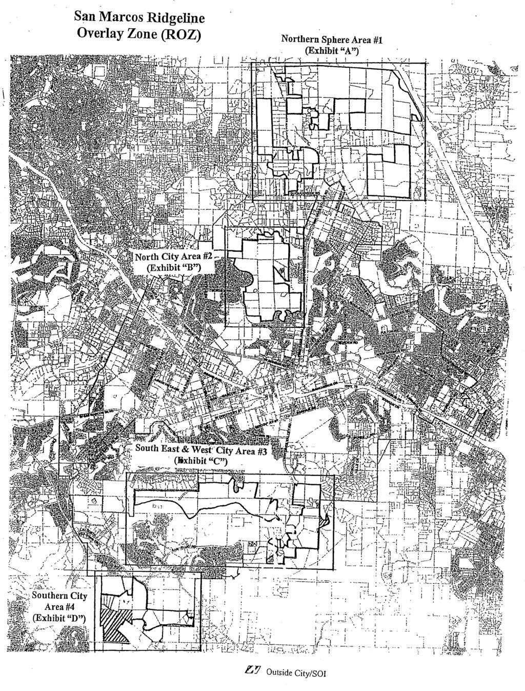
1 Development Services Tel: Civic Center Drive Fax: San Marcos, CA Web: Mr. Devon Muto Department of Planning and Land Use 5201 Ruffin Road, Suite B San Diego, CA Subject: Comprehensive General Plan Update and Draft EIR Response LOG No. 02-ZA-001; SCH NO Thank you for giving the City of San Marcos an opportunity to respond to the Comprehensive General Plan Update Draft EIR (DEIR). The City of San Marcos has the following General Plan Update and DEIR comments: Aesthetics: On February 14, 2006, the San Marcos City Council adopted a Ridgeline Protection and Management Zone within the City limits that became effective on March 16, During the process of zone establishment, a Ridgeline Task Force considered four study areas (exhibit attached) within the both the City limits and City Sphere of Influence. Page of the Aesthetics section of the DEIR references San Marcos Mountains, but does not include other ridgeline study areas identified in the Sphere of Influence (SOI) by the City such as: Merriam Mountains north of the City, a primary ridgeline extending from east to west near the abandoned San Marcos landfill in the south of the City, and a County area to the east of San Elijo Hills (Frank s Peak and Mt. Whitney). Please include review and analysis of these areas in the Aesthetics section of the DEIR since these are locally and regionally significant The City of San Marcos requests that the General Plan include in addition to Policy M-2.3, a policy that specifically includes uses of design measures, including landscape, to soften roadways that are proposed for widening in rural areas such as Deer Springs Road from the San Marcos City limits to the I-15. Biology: The City requests a consultation to insure consistency between the MHCP Focused Planning Area and linkages identified in the City of San Marcos Subarea Plan and the County MSCP Core Resource Area identified in the DEIR. The City has identified two County Resource Areas inconsistent with the City of San Marcos Subarea Plan. o The SM1 area identified on Figure identified in the Adopted and Draft MSCP Core and Linkage Area Figure as a Core Resources Area in the
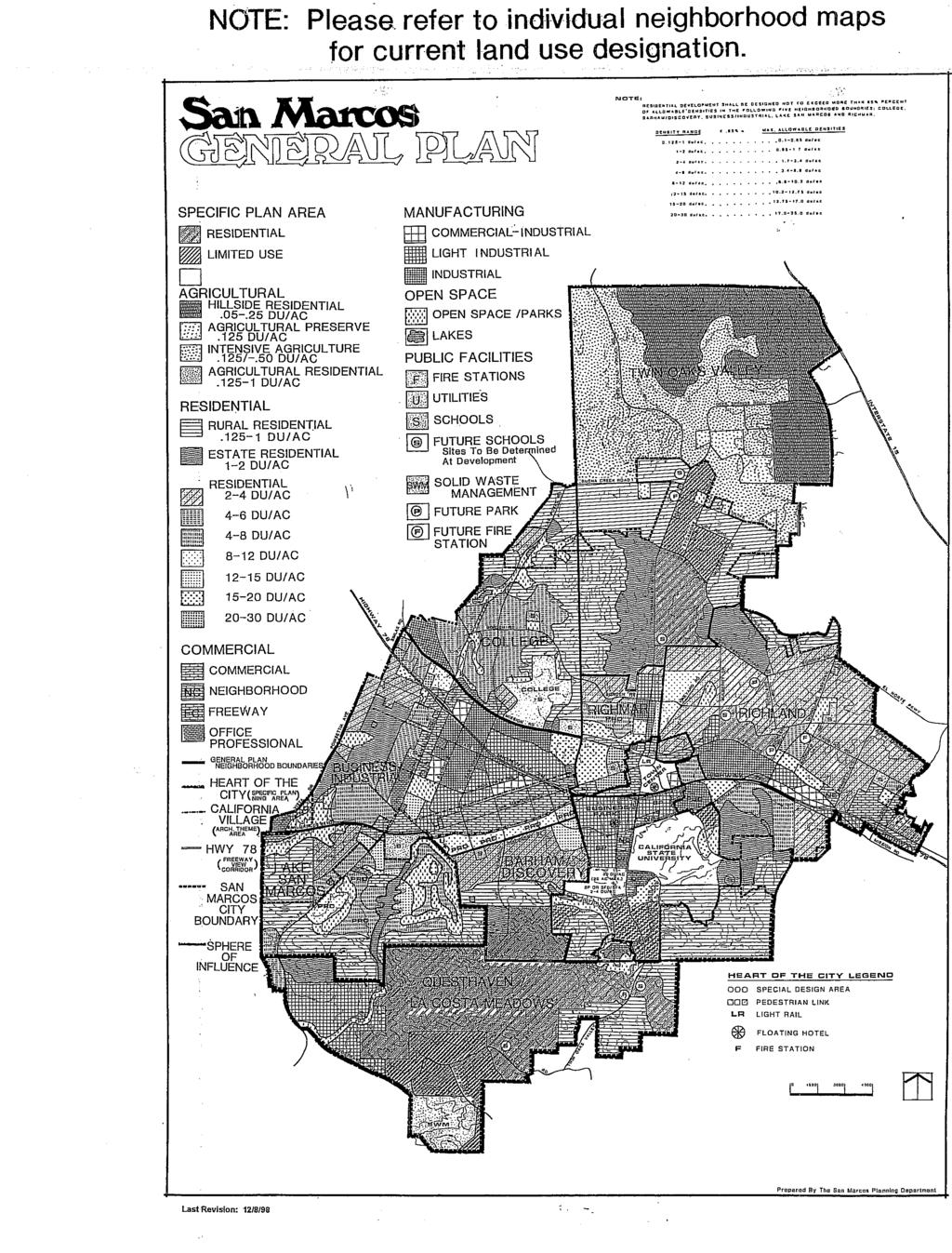
2 Department of Planning & Land Use County General Plan Draft EIR Page 2 of 6 Draft North County MSCP Core and Linkages Areas (Figure 2.3-4) is identified with a 50% vegetation impact. The City has mapped a portion of this area in the City s Subarea Plan in the North Focused Planning Area. Since Figure does not specify which 50% of the area would be impacted, the City is unable to verify consistency. Please provide confirmation that the 50% impact is consistent with the City Subarea Plan. o The City Subarea Plan Focused Planning Area Subareas Figure 4 identifies property within the southeast corner of our City as 60% preserve adjacent to an area of the County identified as 100% impacted on Figure of the DEIR, the Estimated Vegetation Impact Adopted and Draft MSCP Core and Linkage Area. Land Use: The County I-55 Policy states that annexation of developed or developing areas which are and adjacent to cities is generally encouraged when appropriate factors are applicable. The City requests that policies be incorporated into the General Plan that reiterates the approach that the County continues to support annexation of County unincorporated areas within City sphere areas when the appropriate factors listed in the I-55 policy area applicable. SOI City Land Use: Table includes City designated land uses that are not listed correctly. Please refer to the City of San Marcos General Plan map (attached) for correct designations. Land Use Compatibility: The SM1 area identified on Figure is proposed for modification from 1 dwelling per acre to SR-10 (1 du/10 and 20 acre). The area however is surrounded by SR-1, VR-2, SR-0.5, and one acre minimum in the City of San Marcos. The change to a SR-10 would create a 10 acre minimum within the Las Posas Road corridor that is surrounded by a one/two acre minimum area located adjacent to the City of San Marcos, creating an incompatible density in this area. Further, the approved San Marcos Highland Specific Plan includes SM1 with a one acre minimum density in the San Marcos General Plan. SM 6/SM 7: The City of San Marcos General Plan designates these areas as 4-8 du/acre and du/acre. The County General Plan update to change these areas to a 24 du/acre designation is not consistent with the City of San Marcos General Plan and the existing single family development in this area. SM 11: The City of San Marcos had acquired a portion of SM 11 for open space mitigation for the Rancho Santa Fe Road alignment. The City requests the open space mitigation parcel be designated as open space within the County of General Plan. The City will include this change in the City of San Marcos General Plan update. SM 13/SM 14: The City of San Marcos has designated both of these areas as Light Industrial both parcels are adjacent to existing industrial type uses (SM 13 is adjacent to the Escondido Meyers Industrial Park area and SM 14 is adjacent to the closed San Marcos Landfill site approved as part of a Film Studio Specific Plan Area and includes proximity to the La Costa Meadows Industrial Park in the City of San Marcos). Residential land uses designations in these areas is incompatible with adjacent uses especially as project proponents have discussed with City staff development of light industrial, not residential uses, on these properties and future City annexation. Public Services/Fire Protection:
3 Department of Planning & Land Use County General Plan Draft EIR Page 3 of 6 The subject site is located within the San Marcos Fire Protection District (SMFPD). The DEIR states that there will be a need for additional fire protection services to serve new development as increasing population and housing in areas that are not currently able to meet travel time goals would result in the need for new or expanded fire facilities to be constructed so that acceptable travel times can be met (Page ) and that cumulative project impacts would result in a need for additional fire protection services to serve new development (Page ). The City appreciates inclusion of the following policy: o Policy S-6.3: Funding Fire Protection Services. Require development to contribute its fair share towards funding the provision of appropriate fire and emergency medical services as determined necessary to adequately serve the project. The City does, however, ask that the DEIR provide more specific mitigation measures as to how funding will be accomplished, including that projects within the San Marcos Fire Protection District annex into the City of San Marcos Fire Protection District Community Facilities District to provide a funding source for the provision of fire services. Recreation/Trails: Trails section of Mobility Element: There is no Twin Oaks Community Trail Plan in the document. This leaves trails within the City of San Marcos disconnected from other jurisdictions with no northern regional connections to Vista, Bonsall, Fallbrook, Valley Center, Hidden Meadows, Escondido and northern Twin Oaks Valley. Recreation Element 2.14: The County General Plan Update calls for 10 acres per 1,000 population for local parks in addition to 15 acres per 1,000 population of Regional Parks. They currently have only yields 2 acres /1,000 of local parks. As such, additional park lands need to be provided as future development occurs. There are no existing local or regional parks in the Twin Oaks Community. The County needs to plan local parks in this area, or there should be a contribution towards parks in San Marcos for County residents to use. Overall, increases in County population adjacent to San Marcos would result in increased use of San Marcos recreational facilities from County project residents, and the potential to result in the deterioration of San Marcos facilities. The County General Plan Update therefore could have a direct and cumulative impact on recreational facilities in San Marcos not mitigated for in the DEIR. The County has the potential to collect fees for recreational development from County projects and apply this money to develop facilities in other areas, leaving San Marcos to provide for this impact. Therefore, the City requests that projects pay a fair share contribution for park improvements for projects which have a direct and cumulative impact to parks within the City of San Marcos. The wording on Page refers to a quarter mile wide general alignment corridor for the general location of future trails. This wording has lead to confusion in the past, and has allowed City of San Marcos Sphere of Influence area residents to argue against having any trails, given the perceived dedication requirement potentially resulting in a quarter mile wide trail easement.
4 Department of Planning & Land Use County General Plan Draft EIR Page 4 of 6 Page and Figure does not include the Inland Rail-Trail, which should be added as a regional trail. The proposed County General Plan Update does not specifically site or plan recreational facilities (page ). There should be a Master Park Plan required that shows how the County will mitigate the lack of new recreational facilities. Traffic/Mobility: Appendix E Page E-2: Deer Springs Road has been identified to be six lanes from I-15 to Buena Creek Road. The limits identified cross over to San Marcos Jurisdiction by about 1700 feet. Deer Springs Road in San Marcos as well as Twin Oaks Valley Road from Deer Springs Road to Buena Creek is identified as a four lane Rural Major Arterial on the City of San Marcos Circulation Element. Said roadway would have a capacity of ADT at LOS D which appears to be adequate to handle the 2030 volumes without having to upgrade to six (6) travel lanes. The City is currently in the process of updating its General Plan. The update will include an examination of the adequacy of the roadway system to include consideration of Twin Oaks Valley Road and Deer Springs Road to determine a recommendation for the appropriate designation of each roadway. Appendix H page 24: Forecast volumes are substantially different from recent studies conducted for City projects. Furthermore the roadway designations for Twin Oaks Valley Road (TOVR), La Cienega and Mulberry are incorrect. TOVR is a divided four lane arterial and La Cienega and Mulberry are Collectors. Appendix H Page 32: Forecast volumes are substantially different from recent studies conducted for City of San Marcos projects. Therefore, the LOS would most likely be different. Furthermore the roadway designations for Twin Oaks Valley Road (TOVR), La Cienega and Mulberry are incorrect. TOVR is a divided four lane arterial and La Cienega and Mulberry are Collectors. Appendix H Page 52: Same comments as in previous bullet. The forecast ADT s and the LOS for City roadways are substantially different in comparison with recent studies done by the City and even the County. It is recommended that SANDAG Series 11 Combined North County Model should be utilized or attempt to reconcile discrepancies with the North County Model. The project s impacts on the City streets and key intersections (which are missing from the report) should be analyzed where impacts are anticipated. Please provide an explanation on how certain streets have been chosen for analysis. Provide a discussion relative to the County s role in mitigating the project s significant impacts on the City streets and intersections. County should consider requiring Transportation Demand Management (TDM) from projects as a partial or full mitigation of the project impacts on the vicinity roadways and intersections. The County and the City should work together to improve traffic flow across the jurisdictional boundaries by interconnecting signals on arterial and other major streets. Portions of SR-78 within the City limits currently function at LOS F. New County projects will worsen the delays. The County should mitigate its impacts on SR-78 by contributing towards a corridor study for the stretch of the highway within the North County cities as well as participating in the implementation of the recommended improvements. In addition, the County should implement an in-lieu payment fee structure for future development that shall be specifically set aside for SR-78 improvements. The City has been collecting a SR-
5 Department of Planning & Land Use County General Plan Draft EIR Page 5 of 6 78 interchange impact fee since 1990 which has resulted in three new/upgraded interchanges and several auxiliary lanes. The City is committed to participating in the corridor study and coordinate with SANDAG and Caltrans to determine a supplementary traffic impact fee that will pay for SR-78 capacity upgrades. Hydrology/Water Quality: It is not clear if the change in the land uses per the General Plan update would result in an increase in the surface runoffs into San Marcos Creek. If the runoffs are increased due to the proposed changes then mitigation measures such as a financial contribution to improve downstream facilities should be considered. Potential Land Use changes that could result in increased runoff and corresponding sediment loading downstream should have corresponding mitigation policies that include the current and future San Diego County Municipal Stormwater Permit hydromodification development requirements to retain and infiltrate increased development runoff onsite. Table (Page ) Water Bodies currently identified as impaired under the State Water Resources Control Board (SWRCB) 303(d) listing (attached) are not included. In particular, Agua Hedionda Creek, Lake San Marcos and San Marcos Creek are not listed under the Carlsbad Watershed Management Area. In addition, the SWRCB will be updating this list within the month and this updated information should be reflected in Table Table 2.81 and corresponding policies to reduce pollutant loading to these 3039d0 listed water bodies should be coordinated through the respective County Watershed Planners. Mitigation measures (starting at Section , page ) should identify policies and/or pollutant management plans, education, or Best Management Practices to reduce potential increased pollutant loads to 303(d) listed water bodies. Under the Local Regulatory Framework section (page ), the discussion should make reference to compliance with the Municipal Separate Storm Sewer Systems Permit (MS-4, Order No. R ). The City requests a meeting with the County General Plan Update staff to review this letter, including your traffic analysis, land use, MSCP, recreation/trails and Storm Water Management team members. Thank you in advance for your consideration of this request. Please contact Susan Vandrew Rodriguez at , ext to schedule the requested meeting with City Engineering and Planning staff. Sincerely, Jerry Backoff Planning Division Director Enclosures (3): City of San Marcos General Plan Map San Marcos Ridgeline Overlay Zone (ROZ) Study Areas Exhibit Water Resources Control Board (SWRCB) 303(d) listing cc: Paul Malone, City Manager
6 Department of Planning & Land Use County General Plan Draft EIR Page 6 of 6 Lydia Romero, Deputy City Manager Charlie Schaffer, Development Services Director Michael Edwards, City Engineer Sassan Haghgoo, Deputy City Engineer Todd Newman, Fire Chief Mathew Ernau, Fire Marshall Craig Sargent-Beach Community Services Director Erica Ryan Stormwater Manager Susan Vandrew Rodriguez, Associate Planner
7
8
9
10
SECTION 2.0 INTRODUCTION
 SECTION 2.0 INTRODUCTION 2.1 PURPOSE AND SCOPE OF THE EIR Environmental Impact Reports (EIR) are informational documents which wil inform public agency decision-makers and the public generally of the significant
PLANNING COMMISSION. Submitted
 PLANNING COMMISSION City Hall 1275 Main Street El Centro, CA 92243 Submitted PLANNING COMMISSION ACTION ITEM (1844) Meeting: 05/10/16 12:00 AM Department: Community Development Category: Public Hearing
4. ENVIRONMENTAL IMPACT ANALYSIS 7. LAND USE AND PLANNING
 4. ENVIRONMENTAL IMPACT ANALYSIS 7. LAND USE AND PLANNING 4.7.1 INTRODUCTION The following analysis discusses the consistency of the Proposed Project with the corresponding land use and zoning designations
3.10 LAND USE AND PLANNING
 3.10 LAND USE AND PLANNING This section discusses the existing environmental conditions and land use characteristics within the planning area. This section evaluates the potential land use impacts associated
TABLE OF CONTENTS. Tables Table UC Davis Park and Open Space Resources
 TABLE OF CONTENTS 4.13 Recreation... 4.13-1 4.13.1 Environmental Setting... 4.13-1 4.13.2 Impacts and Mitigation Measures... 4.13-4 4.13.3 References... 4.13-8 Tables Table 4.13-1 UC Davis Park and Open
Right-of-Way Acquisitions and Relocations Technical Memorandum
 Right-of-Way Acquisitions and Relocations Technical Memorandum Southeast Extension Project Lincoln Station to RidgeGate Parkway Prepared for: Federal Transit Administration Prepared by: Denver Regional
GENERAL PLAN CONSISTENCY ANALYSIS
 GENERAL PLAN CONSISTENCY ANALYSIS Prepared by Planning Staff 10/28/2013 APPLICABLE GOALS, POLICIES AND PROGRAMS FROM the LAND USE CHAPTER Goal LU-1 Policy LU-1.1 Policy LU-1.2 Goal LU-2 Protect the character
Michael D, Harvey, Current Planning Supervisor. This project was originally approved in 2012 by the BOCC and is summarized as follows:
 PLANNING & INSPECTIONS DEPARTMENT Craig N. Benedict, AICP, Director Current Planning (919) 245-2575 (919) 644-3002 (FAX) www.orangecountync.gov 131 W. Margaret Lane Suite 201 P. O. Box 8181 Hillsborough,
MEETING DATE: November 12, 2013 SUBJECT: Accept Borden Road Bridge Improvement (CIP No )
") AGENDA REPORT Meeting of the San Marcos City Council MEETING DATE: November 12, 2013 SUBJECT: Accept Borden Road Bridge Improvement (CIP No. 88165) Recommendation Staff recommends the City Council adopt
AGENDA REPORT Meeting of the San Marcos City Council MEETING DATE: November 12, 2013 SUBJECT: Accept Borden Road Bridge Improvement (CIP No. 88165) Recommendation Staff recommends the City Council adopt
4.8 Landform Alteration and Aesthetics
 4.8 Landform Alteration and Aesthetics 4.8 LANDFORM ALTERATION AND AESTHETICS This section describes the potential environmental effects related to temporary and permanent impacts to landform and aesthetics,
9 CITY OF VAUGHAN OFFICIAL PLAN AMENDMENT NO BOCA EAST INVESTMENTS LIMITED
 9 CITY OF VAUGHAN OFFICIAL PLAN AMENDMENT NO. 631 - BOCA EAST INVESTMENTS LIMITED The Planning and Economic Development Committee recommends the adoption of the recommendations contained in the following
12 February 9, 2011 Public Hearing APPLICANT: WILDLIFE RESPONSE, INC.
 12 February 9, 2011 Public Hearing APPLICANT: WILDLIFE RESPONSE, INC. PROPERTY OWNER: CITY OF VIRGINIA BEACH REQUEST: Conditional Use Permit (Wildlife Rehabilitation Center) STAFF PLANNER: Karen Prochilo
CHAPTER 2 SUMMARY 1. PROJECT SUMMARY DATA
 CHAPTER 2 SUMMARY This is an Initial Study format used to determine, pursuant to CEQA Guidelines Section 15177, whether a project 1) is within the scope of a Master EIR (MEIR), 2) may result in additional
Appendix G Response to Comments
 Appendix G Response to Comments This appendix contains the comments received during the public circulation and comment period (May 27, 2008 to July 11, 2008). The comments have been numbered (Comment Set
COMMUNITY DEVELOPMENT SERVICES PLANNING AND BUILDING DEPARTMENT PLACERVILLE OFFICE:
 COMMUNITY DEVELOPMENT SERVICES PLANNING AND BUILDING DEPARTMENT http://www.edcgov.us/devservices/ PLACERVILLE OFFICE: LAKE TAHOE OFFICE: 2850 Fair Lane Court, Placerville, CA 95667 924 B Emerald Bay Rd.
RECREATION AND OPEN SPACE ELEMENT GOALS, OBJECTIVES, AND POLICIES
 RECREATION AND OPEN SPACE ELEMENT GOALS, OBJECTIVES, AND POLICIES Goal 7 To provide park facilities, recreation programs, and open space resources that are safe, adequate, and accessible to all City residents,
Table of Contents G.1.a Water Resources - Surface Water - Drainage
 Table of Contents G.1.a Water Resources - Surface Water - Drainage 1. INTRODUCTION... 1335 2. ENVIRONMENTAL SETTING... 1335 a. Regional Hydrology... 1335 b. Local Hydrology... 1337 c. On-site Hydrology...
3.10 LAND USE SETTING PROJECT SITE EXISTING LAND USE DESIGNATIONS AND ZONING. General Plan Land Use Designations.
 This section of the Draft EIR addresses the existing land uses on and adjacent to the project site and discusses the potential impacts of the proposed project on existing land uses. Key issues addressed
Item 10E 1 of 5
 MEETING DATE: January 27, 201 PREPARED BY: Erik Steenblock, Environmental Programs Manager DEPT. DIRECTOR: Glenn Pruim DEPARTMENT: Public Works CITY MANAGER: Karen P. Brust SUBJECT: STORMWATER BEST MANAGEMENT
12.0 LAND USE AND PLANNING
 This section describes the existing and proposed land uses and land use designations on each of the project sites and surrounding properties, and analyzes the potential for the project to conflict with
1.0 Introduction. Purpose and Basis for Updating the TMP. Introduction 1
 1.0 Introduction The Town of Castle Rock is situated between the metropolitan areas of Denver and Colorado Springs, amidst a unique terrain of rolling hills, mesas, ravines, and waterways. Like many Front
Dwelling Units Max 12 dwelling units per acre/min 8 dwelling units per acre. Development Mix 80% non residential/20% residential
 13. OSTEEN LOCAL PLAN Background: The Osteen Local Plan area is located in southwest Volusia County along the SR 415 corridor between Lemon Bluff Road and Acorn Lake Road and includes 3,990 acres. The
SAN RAFAEL GENERAL PLAN 2040 INTRODUCTION AND OVERVIEW
 SAN RAFAEL GENERAL PLAN 2040 INTRODUCTION AND OVERVIEW Steering Committee Presentation February 14, 2018 Purpose of General Plan Guide land use and development decisions Coordinate transportation, infrastructure,
SECTION 4(f) DE MINIMIS DOCUMENTATION
 DE MINIMIS DOCUMENTATION") SECTION 4(f) DE MINIMIS DOCUMENTATION Illinois Route 60/83 IL 176 to the intersection of IL 60 (Townline Road) Lake County P-91-084-07 Mundelein Park and Recreation District Project Limit SECTION 4(f)
SECTION 4(f) DE MINIMIS DOCUMENTATION Illinois Route 60/83 IL 176 to the intersection of IL 60 (Townline Road) Lake County P-91-084-07 Mundelein Park and Recreation District Project Limit SECTION 4(f)
Welcome. Comprehensive Plan & Transportation Plan Open House November 7, 2012
 Welcome Comprehensive Plan & Transportation Plan Open House November 7, 2012 Agenda Proposed future land use plan Comprehensive Plan strategies Traffic forecasts Future traffic operations Possible future
WELCOME! 8 8:30 6: TH STREET IMPROVEMENTS. Open House. Presentation & Q&A
 WELCOME! 168 TH STREET IMPROVEMENTS 6:30 Open House 7 8 Presentation & Q&A 8 8:30 Open House WELCOME Todd Pfitzer City of Omaha Engineer Bob Stubbe City of Omaha Public Works Director Jon Meyer Project
Secrest Short Cut and Monroe Expressway Small Area Plan AUGUST 29, 2018
 Secrest Short Cut and Monroe Expressway Small Area Plan AUGUST 29, 2018 Background and Process Monroe Expressway will be open by the end of 2018 Union County and Indian Trail identified a need to revisit
HAZARD MITIGATION GOALS AND OBJECTIVES
 SEWRPC Community Assistance Planning Report No. 282, 2nd Edition CITY OF MILWAUKEE ALL HAZARDS MITIGATION PLAN UPDATE Chapter IV HAZARD MITIGATION GOALS AND OBJECTIVES [NOTE: Throughout this plan update
SONOMA LOCAL AGENCY FORMATION COMMISSION
 For accessibility assistance with any of the following documents, please contact Sonoma LAFCO at (707) 565-2577 or email us at cynthia.olson@sonoma-county.org. SONOMA LOCAL AGENCY FORMATION COMMISSION
COLVER ROAD INDUSTRIAL CONCEPT PLAN
 COLVER ROAD INDUSTRIAL CONCEPT PLAN A CONCEPTUAL LAND USE AND TRANSPORTATION PLAN FOR TA-4 AN URBAN RESERVE AREA OF THE CITY TALENT City of Talent Adopted by City Council Resolution No., June, 2015 PART
SUBJECT: Comments on Del Mar Fairgrounds Master Plan Draft Environmental Impact Report
 Dustin Fuller, Sr. Environmental Planner 22 nd District Agricultural Association Del Mar Fairgrounds 2260 Jimmy Durante Boulevard Del Mar, CA 92014-2216 February 5, 2010 SUBJECT: Comments on Del Mar Fairgrounds
I-494 Rehabilitation Project SP (I-394 to Fish Lake Interchange) June 2014 Section 4(f) De Minimis Determination
 June 2014 Section 4(f) De Minimis Determination") I-494 Rehabilitation Project SP 2785-330 (I-394 to Fish Lake Interchange) June 2014 Section 4(f) De Minimis Determination State Project Number 2785-330 Federal Project No. NHPP-I494 (002) Trunk Highway:
I-494 Rehabilitation Project SP 2785-330 (I-394 to Fish Lake Interchange) June 2014 Section 4(f) De Minimis Determination State Project Number 2785-330 Federal Project No. NHPP-I494 (002) Trunk Highway:
TREASURE COAST REGIONAL PLANNING COUNCIL M E M O R A N D U M. To: Council Members AGENDA ITEM 5H
 TREASURE COAST REGIONAL PLANNING COUNCIL M E M O R A N D U M To: Council Members AGENDA ITEM 5H From: Date: Subject: Staff October 17, 2008 Council Meeting Local Government Comprehensive Plan Review Draft
4-Town Comprehensive Plan DRAFT 7/30/07
 4-Town Comprehensive Plan DRAFT 7/30/07 Acknowledgements ning Committee Town of Harrisburg Norman Roof Randy Nicol Town of Martinsburg Terry Thisse Paul Kelly Town of Montague Jan Bagdanowicz Wendy Perry
Public Review Draft Encinitas Subarea Plan
 Encinitas Subarea Plan Prepared for City of Encinitas Community Development Department 505 S. Vulcan Encinitas, California 92024 Prepared by Ogden Environmental and Energy Services Co., Inc. 5510 Morehouse
MEMORANDUM AGENDA ITEM #6c
 South Florida Regional Planning Council MEMORANDUM AGENDA ITEM #6c DATE: FEBRUARY 1, 2010 TO: FROM: SUBJECT: COUNCIL MEMBERS STAFF CITY OF PARKLAND PROPOSED COMPREHENSIVE PLAN AMENDMENT (ALTERNATIVE REVIEW)
PROJECT DESCRIPTION ENVIRONMENTAL SETTING. Project Site Location FIGURE 1 - REGIONAL LOCATION MAP
 PROJECT DESCRIPTION ENVIRONMENTAL SETTING Project Site Location The proposed project site is located within the City of Camarillo in Ventura County. As shown in Figure 1, the City of Camarillo is located
Chapter 13: Implementation Plan
 Implementation A. Introduction The Implementation Plan, in table form on the following pages, provides a summary of all the Action Items recommended in Chapters 2 through 12. The table also indicates which
Appendix E Preliminary Location Hydraulic Study
 Appendix E Prepared for: State of Alaska Department of Transportation and Public Facilities Prepared by: HDR Alaska, Inc. 2525 C Street, Suite 305 Anchorage, Alaska 99503 February 2014 This page intentionally
5.13 RECREATION / OPEN SPACE
 5.13 RECREATION / OPEN SPACE The project includes the development of two 5+ acre public parks, four pocket parks and various trails. This complies with the Board of Supervisors established minimum standard
I. DESCRIPTION OF PROPOSED ACTION... 1 A. General Description... 1 B. Historical Resume and Project Status... 2 C. Cost Estimates...
 PROJECT COMMITMENTS SUMMARY... S-1 1. Type of Action... S-1 2. Description of Action... S-1 3. Summary of Purpose and Need... S-1 4. Alternatives Considered... S-2 5. NCDOT Alternatives Carried Forward...
CHAPTER 3 AFFECTED ENVIRONMENT; ENVIRONMENTAL CONSEQUENCES; AND AVOIDANCE, MINIMIZATION, AND/OR MITIGATION MEASURES
 CHAPTER 3 AFFECTED ENVIRONMENT; ENVIRONMENTAL CONSEQUENCES; AND AVOIDANCE, MINIMIZATION, AND/OR MITIGATION MEASURES The following technical reports were prepared in support of this Final Environmental
Woodburn Comprehensive Plan Growth Management Goals and Policies
 Goal Woodburn Comprehensive Plan Growth Management Goals and Policies G-1. The City's goal is to manage growth in a balanced, orderly and efficient manner, consistent with the City s coordinated population
3. VISION AND GOALS. Vision Statement. Goals, Objectives and Policies
 Vision Statement Queen Creek s interconnected network of parks, trails, open spaces and recreation opportunities provide safe and diverse activities and programs that sustain its unique, small town, equestrian
TIRZ 17/Redevelopment Authority Capital Improvements Plan Projects
 Gessner Widening: T-1701 What: Widen the road from a six-lane divided boulevard to an eight-lane divided boulevard street section, increase turn lanes, update traffic signal system, improve drainage by
GENERAL LAND USE PLAN ELEMENT
 CITY OF Prepared by City of Medford Planning Department 200 South Ivy Street Medford, Oregon 97501 plnmed@ci.medford.or.us James E. Huber, AICP, Planning Director COMPREHENSIVE PLANNING SECTION John Adam,
WEST HILL BUSINESS PARK AREA STRUCTURE PLAN
 MUNICIPAL DISTRICT OF PEACE NO. 135 WEST HILL BUSINESS PARK AREA STRUCTURE PLAN Prepared by: TABLE OF CONTENTS 1.0 Introduction... 1 1.1 Purpose of Plan........ 1 1.2 Plan Area..... 1 1.3 Existing Conditions...
Transportation. Strategies for Action
 Transportation A major priority for the Overlake Neighborhood is to develop a multimodal transportation system. To achieve this system, a balance has to be found among travel, circulation and access needs;
The Illinois Department of Transportation and Lake County Division of Transportation. Route 173, including the Millburn Bypass
 The Illinois Department of Transportation and Lake County Division of Transportation welcome you to this Public Hearing for U.S. Route 45 from Illinois Route 132 to Illinois Route 173, including the Millburn
2. AGENCY COORDINATION AND PUBLIC INVOLVMENT
 2. AGENCY COORDINATION AND PUBLIC INVOLVMENT This chapter discusses the process carried out for conducting agency coordination and public involvement activities. TECHNICAL ADVISORY COMMITTEE A Technical
ADOPTED CAPITAL IMPROVEMENT PROGRAM BUDGET ARROYO PROJECTS
 ADOPTED CAPITAL IMPROVEMENT PROGRAM BUDGET ARROYO PROJECTS HAHAMONGNA FY 212-216 Capital Improvement Program Priority Description Total Estimated Costs Appropriated Through FY 211 Adopted FY 212 FY 213
CHAPTER 1. Ms. Guajardo s Class - Central Elementary CH 1 1
 INTRODUCTION CHAPTER 1 Ms. Guajardo s Class - Central Elementary CH 1 1 1.1 SETTING South Centre City is a linear corridor south of Downtown Escondido paralleling Centre City Parkway and South Escondido
ARROYO PROJECTS ADOPTED CAPITAL IMPROVEMENT PROGRAM BUDGET
 A RROYO P ROJECTS ADOPTED CAPITAL IMPROVEMENT PROGRAM BUDGET FISCAL YEARS 214-218 HAHAMONGNA Priority Description 1 Hahamongna Watershed Park - Implement Master Plan 211,6 211,6 (77565) 2 Hahamongna -
Introduction and Overview
 Introduction and Overview Articulate local values and priorities Guide land use and development decisions Coordinate transportation, infrastructure, and City services with expected growth and available
Venice Pumping Plant Dual Force Main Project Draft EIR
 City of Los Angeles 5.9 LAND USE PLANS 5.9.1 Environmental Setting Venice Pumping Plant Dual Force Main Project Draft EIR The Project lies within the bounds of Los Angeles County and the City of Los Angeles.
EXECUTIVE SUMMARY. Introduction
 EXECUTIVE SUMMARY Introduction State Route 68 is a designated scenic route that connects the world-renowned Monterey Peninsula to US Highway 101 and the Salinas Valley. SR 68 is a key route for bicycle,
TRANSPORTATION ELEMENT GOALS, OBJECTIVES, AND POLICIES
 TRANSPORTATION ELEMENT GOALS, OBJECTIVES, AND POLICIES GOAL 2 The City shall provide a safe, convenient, effective, and energy efficient multimodal transportation system which is coordinated with the Future
Issues Requiring Future Study
 Issues Requiring Future Study Transportation planning is an ongoing process that tends to identify new issues as it finds solutions for others. Some issues are so complex that a solution to one problem
STAFF REPORT TO THE CITY COUNCIL. Conduct Public Hearing to vacate certain public right of way adjacent to Sycamore Avenue and San Pablo Avenue
 STAFF REPORT TO THE CITY COUNCIL DATE: Adjourned Regular Meeting of December 16, 2014 TO: SUBMITTED BY: SUBJECT: Mayor and Members of the City Council Holly Smyth, Planning Director Conduct Public Hearing
SUSSEX COUNTY COMPREHENSIVE PLAN COUNTY PLANNING AND ZONING COMMISSION WORKSHOP
 SUSSEX COUNTY COMPREHENSIVE PLAN COUNTY PLANNING AND ZONING COMMISSION WORKSHOP August 21, 2017 TODAY S WORKSHOP Public Comment Utilities Update Economic Development Update Future Land Use Discussion Public
Riverside County Flood Control and Water Conservation District LAKELAND VILLAGE MDP LINE H, STAGE 1
 Riverside Flood Control and Water Conservation District Riverside, California LAKELAND VILLAGE MDP LINE H, STAGE 1 CEQA ADDENDUM TO THE FINAL PROGRAM ENVIRONMENTAL IMPACT REPORT FOR THE LAKELAND VILLAGE
PRELIMINARY REPORT. HIGHWAY 18 CORRIDOR NEIGHBORHOOD PLAN VILLAGE OF DOUSMAN November, 2014
 PRELIMINARY REPORT HIGHWAY 18 CORRIDOR NEIGHBORHOOD PLAN VILLAGE OF DOUSMAN November, 2014 This preliminary report presents the initial recommendations for land use within the Highway 18 corridor along
Department of Community Development. Planning and Environmental Review Division Revised Notice of Preparation
 Department of Community Development Michael J. Penrose, Acting Director Divisions Building Permits & Inspection Code Enforcement County Engineering Economic Development & Marketing Planning & Environmental
CHAPTER 7: Transportation, Mobility and Circulation
 AGLE AREA COMMUNITY Plan CHAPTER 7 CHAPTER 7: Transportation, Mobility and Circulation Transportation, Mobility and Circulation The purpose of the Transportation, Mobility and Circulation Chapter is to
Regarding actual construction when development occurs, the following applicable guidelines are provided to address public safety issues:
 MIAMI-DADE COUNTY DEPARTMENT OF PLANNING AND ZONING General Comments 1. COMMENT: A careful review of the application provided shows that there is likely to be an impact on the Miami-Dade Police Department
Description of Preferred Alternative
 Chapter 2 Description of Preferred Alternative 2.1 Introduction This chapter of the programmatic Sammamish Town Center Sub-area Plan Final EIS provides a more detailed description of the Preferred Alternative
1.0 Circulation Element
 5/9/18 1.0 Circulation Element 1.1 Introduction As growth and development occur in Apache County, enhancements to its circulation system will be necessary. With time, more roads will be paved and air and
I. INTRODUCTION. Project Background and Study Area
 I. INTRODUCTION Project Background and Study Area Freedom Parkway is a key east-west corridor connecting I-25 on the west to the Town of Kersey on the east, running approximately one to two miles south
FY Capital Improvement Program Arroyo Projects
 FY 219-223 Capital Improvement Program FY 218 FY 219 FY 22 FY 221 FY 222 FY 223 1 2 3 4 5 6 7 8 9 1 Hahamongna - Implement Master Plan - Oak Grove Area Improvements (7756) Hahamongna - Implement Master
Mississippi Skyway Preliminary Engineering Report
 EXECUTIVE SUMMARY Mississippi Skyway Preliminary Engineering Report CITY OF RAMSEY, MINNESOTA DECEMBER 2014 City of RAMSEY EXECUTIVE SUMMARY Project Need and Intent The Mississippi Skyway pedestrian bridge
3.0 PROJECT DESCRIPTION
 3.0 PROJECT DESCRIPTION 3.1 BACKGROUND Under California law (Government Code Section 65300 et seq.), every city and county is required to have a general plan. The general plan is to be comprehensive and
Public Review Draft Oceanside Subarea Habitat Conservation Plan/ Natural Communities Conservation Plan
 Oceanside Subarea Habitat Conservation Plan/ Natural Communities Conservation Plan Prepared for City of Oceanside Planning Department 300 N. Coast Highway Oceanside, CA 92054 Prepared by Ogden Environmental
Portage Parkway Environmental Assessment Public Information Centre No. 1
 City of Vaughan Portage Parkway Environmental Assessment Public Information Centre No. 1 November 25, 2015 Welcome to the Public Information Centre This first Public Information Centre (PIC) introduces
2 January 13, 2010 Public Hearing APPLICANT: AUTOBELL CAR WASH, INC
 REQUEST: Conditional Use Permit (car wash) 2 January 13, 2010 Public Hearing APPLICANT: AUTOBELL CAR WASH, INC PROPERTY OWNER: MESSER 1060 INDEPENDENCE BOULEVARD STAFF PLANNER: Carolyn A.K. Smith ADDRESS
C. WATER. 1. Surface Water Runoff. See Section C.3, Flood Hazard/Mudflow Hazard, page Ground Water
 C. WATER 1. Surface Water Runoff See Section C.3, Flood Hazard/Mudflow Hazard, page 67. 2. Ground Water Determined not significant by the October 1984 and January 1999 Initial Studies conducted by the
IH35 Corridor Plan Amendment to the Comprehensive Plan
 IH35 Corridor Plan Amendment to the Comprehensive Plan Background The corridor plan for the IH35 corridor is an amendment to the Burleson comprehensive plan. Generally, the purpose of a corridor plan is
NOTICE OF PREPARATION
 NOTICE OF PREPARATION DATE: January 6, 2016 TO: LEAD AGENCY: Responsible Agencies, Organizations, and Interested Parties Contact: Tyler Barrington, Principal Planner Planning Department Community Development
CONSENT CALENDAR CITY PLANNING COMMISSION AGENDA ITEM NO: A.1, A.2 STAFF: LARRY LARSEN
 Page 8 CONSENT CALENDAR CITY PLANNING COMMISSION AGENDA ITEM NO: A.1, A.2 STAFF: LARRY LARSEN FILE NO: CPC PUZ 14-00013 - QUASI-JUDICIAL FILE NO: CPC PUD 14-00014 QUASI-JUDICIAL PROJECT: APPLICANT: OWNER:
9 th Street Sub Area Plan
 9 th Street Sub Area Plan In the 1990 s, when the Township prepared the last Master Plan, the 9 th Street corridor was studied as part of a larger 9 th Street Focus Area that included the West Main Street
5.8 PUBLIC SERVICES FIRE PROTECTION AND EMERGENCY SERVICES
 5.8 PUBLIC SERVICES FIRE PROTECTION AND EMERGENCY SERVICES 5.8.1 INTRODUCTION This section assesses the proposed projects potential impacts on fire protection services. Information for the following analysis
Subject: Hendry County Evaluation and Appraisal Report Letter of Understanding - Identification of Major Issues
 HENDRY COUNTY PLANNING & ZONING DEPARTMENT POST OFFICE BOX 2340 165 S. LEE STREET LABELLE, FLORIDA 33975 (863) 675-5240 FAX: (863) 675-5317 SUNCOM 744-4750 November 16, 2007 Mr. Mike McDaniel, Chief Office
MODEL ACCESS MANAGEMENT PLAN MINNESOTA TRUNK HIGHWAY 7 COMPREHENSIVE PLAN AMENDMENT (HUTCHINSON SEGMENT)
") MODEL ACCESS MANAGEMENT PLAN MINNESOTA TRUNK HIGHWAY 7 (HUTCHINSON SEGMENT) COMPREHENSIVE PLAN AMENDMENT INTRODUCTION. The purpose of this plan is to provide consistent access management in the Trunk
MODEL ACCESS MANAGEMENT PLAN MINNESOTA TRUNK HIGHWAY 7 (HUTCHINSON SEGMENT) COMPREHENSIVE PLAN AMENDMENT INTRODUCTION. The purpose of this plan is to provide consistent access management in the Trunk
CHAPTER 10-D GREATER MONTEREY PENINSULA AREA PLAN
 CHAPTER 10-D GREATER MONTEREY PENINSULA AREA PLAN GREATER MONTEREY PENINSULA AREA PLAN SUPPLEMENTAL POLICIES 1.0 - Land Use GMP-1.1 GMP-1.2 GMP-1.3 GMP-1.4 GMP-1.5 GMP-1.6 GMP-1.7 GMP-18.6 The County shall
5.0 IMPLEMENTATION STRATEGIES
 5.0 IMPLEMENTATION STRATEGIES 5.1 Recommended Alternative This chapter discusses the anticipated steps needed to move each project from recommendation to construction. Since full funding for these alternatives
Sorted citizen input comments in review of Blount County plans July, August, and September 2007
 Sorted citizen input comments in review of Blount County plans July, August, and September 2007 The following presents sorted citizen input comments from three sessions held in July, August and September
3.0 Cumulative Scenario and Methodology. 3.0 Cumulative Scenario and Methodology
 3.0 Cumulative Scenario and Methodology Under the CEQA Guidelines, a cumulative impact consists of an impact which is created as a result of the combination of the project evaluated in the environmental
 TECHNICAL APPENDIX C General Plan Consistency Review Proposed Lower Lagoon Valley Specific Plan General Plan Consistency Review CHAPTER 2 - LAND USE ELEMENT AMENDMENTS TO FIGURES: General Plan Land Use
Nob Hill Pipeline Improvements Project EIR
 Section 3.1 Aesthetics This section addresses the visual aspects that may affect the views experienced by the public, including the potential to impact the existing character of each area that comprises
The West Vaughan Employment Area Secondary Plan Policies
 Part 2: The West Vaughan Employment Area Secondary Plan Policies 2.1 General Policies It is the policy of Council: 2.1.1. That the West Vaughan Employment Area (the WVEA), identified on Schedule 1, will
Ten Mile Creek Planning Area
 PLANNING AREA POLICIES TEN MILE CREEK Ten Mile Creek Planning Area Location and Context The Ten Mile Creek Planning Area ( Ten Mile Creek area ) is located south of the current Boise AOCI, generally south
CHAPTER 10-D GREATER MONTEREY PENINSULA AREA PLAN
 CHAPTER 10-D GREATER MONTEREY PENINSULA AREA PLAN GREATER MONTEREY PENINSULA AREA PLAN SUPPLEMENTAL POLICIES 1.0 - Land Use GMP-1.1 GMP-1.2 GMP-1.3 GMP-1.4 GMP-1.5 GMP-1.6 GMP-1.7 The County shall overlay
4 LAND USE DESIGNATIONS
 4 LAND USE DESIGNATIONS Chapter 4 describes the land use designations and densities that will implement the development vision for North Burlingame outlined in Chapter 3. Land use densities are described
DEVELOPMENT FRAMEWORK POST 2030 LAND USE PLAN INTRODUCTION
 INTRODUCTION Oak Grove s Comprehensive Plan identifies a future Metropolitan Urban Service Area (MUSA). The Metropolitan Council does not anticipate extending utilities to this area prior to 2030. The
Baumgarten MPUD. Exhibit 3 Evaluation Criteria
 Pursuant to LDC subsections 10.02.13 B, 10.02.08 F and Chapter 3 G. of the Administrative Code, staff s analysis and recommendation to the Planning Commission, and the Planning Commission s recommendation
CHAPTER 10 AESTHETICS
 CHAPTER 10 AESTHETICS CHAPTER 10 AESTHETICS This section identifies and evaluates key visual resources in the project area to determine the degree of visual impact that would be attributable to the project.
OP Council Resolution June 16, Planning and Development Services
 OP-08-01 Council Resolution June 16, 2008 Planning and Development Services Kingsgate Landing Outline Plan Table of Contents 1.0 Introduction 1 1.1 Purpose of Plan 1 1.2 Plan Area Location 1 1.3 Ownership
The transportation system in a community is an
 7 TRANSPORTATION The transportation system in a community is an important factor contributing to the quality of life of the residents. Without a sound transportation system to bring both goods and patrons
RRW Stonebrook, LLC Tentative Map Findings
 RRW Stonebrook, LLC Tentative Map Findings FINDING T1: The request conforms to the Master Plan and zoning ordinances. RELATIONSHIP TO THE MASTER PLAN 1. The respective development is located within an
Planning Commission Staff Report March 15, 2007
 Planning Commission Staff Report Project: Request: Madeira East Tentative Subdivision Map, Design Review for Subdivision Layout & Abandonment of Easements Location: Phase IV of the Laguna Ridge Specific
Exhibit A Comprehensive Plan Amendments
 Exhibit A Comprehensive Plan Amendments May 2010 Draft Chapter One - Introduction Chapter One INTRODUCTION NOTE: For brevity and ease in viewing the proposed changes, portions of chapter one that are not