Rookwood Necropolis. Management Unit Policies. Referenced Document to the Plan of Management Rookwood
|
|
|
- Albert Wade
- 5 years ago
- Views:
Transcription

1 Rookwood Necropolis Management Unit Policies Referenced Document to the Plan of Management 2012 Rookwood November 2011
2 The Management Unit Policies form the basis for implementing the Vision at Rookwood detailed in the Plan of Management In 2010 the Rookwood Visual Significance Study was prepared, updating previous visual analysis from the 1993 Plan of Management and building on values beyond aesthetics. The results of the Visual Significance Study have identified the significant items of the heritage, built, natural and visual character in Rookwood. All of these are incorporated into one document. The study informed the development of Management Units, defining areas of similar physical, cultural and visual values within this large, cultural landscape comprising Rookwood Necropolis. These Units provide smaller manageable precincts for actions to reflect the special characteristics embodied within each Unit, while undertaking the core activities of burial and cremation. A detailed description and assessment of the visual significance of each Management Unit is included in the Rookwood Visual Significance Study The Management Unit Policies for the twenty four Management Units defined within Rookwood Necropolis are presented here to complement the Plan of Management and provide key management priorities for each Unit. The Management Unit Policies are presented as: Brief Description Desired Future Character Key Management Priorities Cemetery or Crematorium Conservation as an historic site Vegetation Conservation Area Strategic Directions SD1 to SD5 Principles P1 to P14 Guidelines Rookwood
3 Management Unit 1 - Wesleyan No. 1 Description: One of the most intact areas within the State Heritage Register listed area- intimate in scale, circular parterres and gardens, vaults, trees- highly articulated with interpretation of historic layers possible. Design accredited to Charles Moore. Desired Future Character: Heritage landscape pattern- brick edges, gardens, trees, vaults- entire Victorian design maintained and interpreted. Visual connection with Mortuary Station reinforced. KEY MANAGEMENT PRIORITIES: Conservation as an historic site including interpretation SD 1 Adopt sustainable management practices P12 Identify opportunities for burial, renewable tenure and renewal schemes whilst maintaining Rookwood values (heritage, social, visual, vegetation) subject to legislation: 12.1 The Unit is in SHR and is not generally suitable for renewable tenure. SD 2 Protect Rookwood s heritage and conserve its environment P 1 Maintain Visual Corridors: 1.1 Maintain the internal foreground views to the circular grassed/ gravel circulation paths. 1.2 Maintain visual connection with Unit 7. P 2 Maintain Historic Circulation Routes including setting and material fabric: 2.1 Maintain curvilinear paths in scale, materials and landscape character. P3 Maintain landscape pattern of areas within State Heritage Register (SHR): 3.1 Protect historic circulation routes in entire area. P4 Maintain landscape design including influences of prominent individuals: 4.1 Maintain the pattern of intact fabric and highly articulated paths and planning of the Charles Moore Plan (one of the best examples of this style at Rookwood). P5 Maintain heritage monuments, features, landmarks of artistic, creative and technical value including their settings: 5.1 Protect and maintain historic vaults including the landscape planting and setting. 5.2 Protect all heritage monuments identified in heritage study- maintain inventory. 5.3 Maintain the spatial qualities and landscape context/setting of all vaults and burial areas. 5.4 Protect character of the Lidcombe gates, walls, sculpture by Hossein Valamanesh and the landscape setting. P6 Interpret significant heritage features and/or heritage items no longer present: 6.1 Strengthen the visual connection with Unit 7, original Mortuary station site. P7 Implement and reinforce established street hierarchy- primary, secondary, tertiary. 7.1 Maintain Necropolis Drive, Necropolis Crt and Cohen Ave - primary roads- RNT to manage existing tree planting as part of a Tree management policy. P8 Maintain significant trees/vegetation/ botanical items of rarity- refer Significant Tree Register and threatened species: 8.1 Maintain all trees and replace via an ongoing tree planting program- high priority are trees at high points near Unit 7.

4 Management Unit 1 - Wesleyan No Maintain all heritage roses. 8.3 Review Camphor Laurels within the Unit -damage to monuments. Take remedial action, in accordance with permissible heritage activities if required. 8.4 Protect all Threatened species- refer PMP. P 10 Recognise high points and ridgelines: visually prominent areas: 10.1 Consult guidelines for ridgeline if undertaking activities in the high point - connection to Unit SD 4 Respect cultural diversity and equitable allocation of resources P11 Maintain representative examples of social/religious group burial practices: 11.1 Retain and protect areas identified in the social mapping study. This Legend applies to all of the Management Unit Plans that follow

5
6 Management Unit 2 - Catholic Area No 1 Description: State Heritage Register Listed Area. First burial Alignment of railway spur is visible. Vaults reduce interpretation potential. Landmarks include St Michael the Archangel chapel, some Devonshire St monuments relocated here, Large Bunya, Hoop pines, trees and palms define circulation routes. Desired Future Character: Trees and circulation avenues defined and maintained, Serpentine protected, Railway spur interpreted, Views to Mortuary Station site reinforced. KEY MANAGEMENT PRIORITIES: Some Cemetery purposes- may be possible without compromising the area. Heritage conservation and interpretation, Possible burial in areas to be identified whilst not compromising heritage conservation SD 1 Adopt sustainable management practices P12 Identify opportunities for burial, renewable tenure and renewal schemes whilst maintaining Rookwood values (heritage, social, visual, vegetation) subject to legislation: 12.1 Areas where renewable schemes could occur are in the central portion and along railway spur. (Refer Plan) P13 Identify opportunities for development and additional burial space whilst maintaining Rookwood wide values (heritage, social, visual, vegetation) 13.1 Investigate areas available for additional burial. P14 Maintain all above ground structures for maintenance of safety, visual and heritage values: SD 2 Protect Rookwood s heritage and conserve its environment P 1 Maintain Visual Corridors: 1.1 Maintain/reinforce view south adjacent William Drive to Unit 7, by ensuring no structure or trees interrupts view. Avenue trees may be used to reinforce view. 1.2 Retain view from St Michael the Archangel northwest over Unit 2. P 2 Maintain Historic Circulation Routes including setting and material fabric: 2.1 Maintain curvilinear Camphor Laurel avenue west of railway spur. 2.2 Maintain mature pines/trees defining circulation routes and progressively replace to retain character. 2.3 Maintain all heritage circulation routes remaining. 2.4 Reinforce the character of William Drive as the original railway reversing area, reinstate heritage trees and recognise its status as a secondary road. P3 Maintain landscape pattern of areas within State Heritage Register (SHR): 3.1 Protect historic circulation routes around St Michael s Chapel and avenues/feature trees defining circulation routes. P4 Maintain landscape design including influences of prominent individuals: 4.1 Refer above P5 Maintain heritage monuments, features, landmarks of artistic, creative and technical value including their settings: 5.1 Retain religious headstones unique in Rookwood 5.2 Protect historic vaults north and west of St Michael s Chapel. 5.3 Protect all heritage monuments identified in heritage study.
7 Management Unit 2 - Catholic Area No Maintain the spatial qualities and landscape context of the setting of St Michael the Archangel Chapel. P6 Interpret significant heritage features and/or heritage items no longer present: 6.1 Strengthen the visual corridor along the railway spur - reinstate tree avenue and design special burial layout that interprets the corridor- ie longitudinal orientation of burials parallel to alignment is preferred. P7 Implement and reinforce established street hierarchy- primary, secondary, tertiary. 7.1 Implement established road hierarchy for William Drive - secondary road - establish tree planting and road profile, along with replacement of heritage/landmark trees. 7.2 Maintain the existing characteristics of Necropolis Drive - primary road, on southern edge of Unit 2. Tree planting (E. microcorys) to be protected and replaced when required P8 Maintain significant trees/vegetation/ botanical items of rarity- refer Significant Tree Register and threatened species: 8.1 Maintain and progressively replace all pines, camphor laurels and trees according to recommendations of significant vegetation study. 8.2 Maintain and reinforce boundary planting to Railway St and East St. P9 Maintain historic serpentine and canal: 9.1 Protect and maintain serpentine including its setting. P 10 Provide special consideration to High points and ridgelines: visually prominent areas: 10.1 Allow the ridgeline to be read in the context of the Unit by avoiding large structures along ridge, as these will conflict with the existing landmark of St Michael the Archangel. SD 4 Respect cultural diversity and equitable allocation of resources P11 Maintain representative examples of social/religious group burial practices-areas identified in social significance study: 11.1 Retain and protect areas identified in social mapping.

8
9 Management Unit 3 - Anglican Area No 1 Description: State Heritage Register- Listed area. First burial Monuments from Old Sydney Burial ground in George St, relocated here. Strong grid arrangement of circulation paths and trees. Design attributed to Simean Pearce, and later JH Maiden- articulated, ornamental design. Serpentine Victorian gardens provided pleasure ground character to Cemeterya major heritage asset. Large mature stone, hoop, bunya pines, cedars of Lebanon, palms. Botanic Garden style of planting recommended by JH Maiden. Includes Vegetation Conservation Area. Desired Future Character: Heritage landscape pattern- brick edges, circular gardens, fountains, statuary, monuments, vaults, maintained. Tree planting maintained and reinforced. KEY MANAGEMENT PRIORITIES: Conservation as an historic site. Vegetation Conservation Area maintained in accordance with PMP. Some Cemetery purposes- in select areas SD 1 Adopt sustainable management practices P12 Identify opportunities for burial, renewable tenure and renewal schemes whilst maintaining Rookwood values (heritage, social, visual, vegetation) subject to legislation: 12.1 Unit is within SHR area and is generally not suitable for renewable tenure. Few opportunities exist whilst maintaining SHR value. P14 Maintain all above ground structures for maintenance of safety, visual and heritage values: SD 2 Protect Rookwood s heritage and conserve its environment P 1 Maintain Visual Corridors: 1.1 Maintain views east from William Drive along circulation paths. 1.2 Maintain views along Serpentine. 1.3 Maintain view along axis to Brick Polychrome Rest House from Necropolis Dr. P 2 Maintain Historic Circulation Routes including setting and material fabric: 2.1 Maintain setting of Serpentine in scale and character. Level of maintenance may be concentrated in areas to reflect Victorian character, whilst other parts may be less intensive- dependent on resources. 2.2 Maintain the scale and character of the grid circulation system, including the circular features at the nodes of the grid. Maintain brick details. 2.3 Maintain connection with Unit 7, Mortuary Station site. P3 Maintain landscape pattern of areas within State Heritage Register (SHR): 3.1 Protect historic circulation routes including the trees in the entire area. P4 Maintain landscape design including influences of prominent individuals 4.1 Protect and maintain designs from Charles Moore, S.Pearce and JH Maiden areas, all represented in this Unit. P5 Maintain heritage monuments, features, landmarks of artistic, creative and technical value including their settings: 5.1 Maintain feature monuments, urns, fountains, serpentine walls and structures (shade-rest houses- particularly restored examples) 5.2 Protect historic vaults. 5.3 Protect naval areas.
10 Management Unit 3 - Anglican Area No 1 P6 Interpret significant heritage features and/or heritage items no longer present: 6.1 Heritage items have been interpreted in this Unit. Investigate any further areas that could be interpreted. (Few additional items require interpretation) P7 Implement and reinforce established street hierarchy- primary, secondary, tertiary. SD 4 Respect cultural diversity and equitable allocation of resources P11 Maintain representative examples of social/religious group burial practices-areas identified in social significance study: 11.1 Retain and protect areas identified in social mapping. 7.1 Implement established road hierarchy for William Drive - secondary road - establish tree planting and road profile. Reflect historic circulation status of William Dr. as access to former Ranger s lodge. 7.2 Maintain the existing characteristics of Necropolis Drive - primary road, on southern edge of Unit 3. Tree planting (P. canariensis) to be protected and replaced when required. Implement management requirements of the palm arboricultural assessment to ensure long term future of tree avenue. Significant Tree Register and management strategy to be undertaken P8 Maintain significant trees/vegetation/ botanical items of rarity- refer Significant Tree Register and threatened species: 8.1 Maintain and progressively replace all significant trees, in particular landmark trees according to results of significant tree register. 8.2 Maintain and reinforce boundary planting along Railway St. 8.3 Maintain Vegetation Conservation area in accordance with the TSC Act requirements and PMP. P9 Maintain historic serpentine and canal: 9.1 Protect and maintain serpentine including its setting and high quality landscape design. P 10 Provide special consideration to high points and ridgelines: visually prominent areas: 10.1 Allow the ridgeline on William Drive to be read in the context of the Unit by avoiding large structures along ridge, replace significant landmark trees (Araucaria sp.) and maintain/manage existing trees Replace and manage significant/landmark trees adjacent Necropolis Crt and connection to Unit 7

11
12 Management Unit 4 - Anglican Description: Monuments early to late 20 th Century. Complimentary to Unit 3 with less detail and smaller nodal features, structures. Pines, palms, trees are visible landmarks. Structures on ridgeline at Hawthorn Ave- All Souls Chapel are also landmarks. Includes Vegetation Conservation Area. Desired Future Character: Western portion from Canal attributed to JH Maiden, to be maintained in its landscape pattern, trees and materials. Grid arrangement retained. KEY MANAGEMENT PRIORITIES: Cemetery purposes - burial in areas to be identified, identification of intensification of use, re- use and renewal schemes. Heritage conservation- Some areas Vegetation Conservation Area maintained in accordance with PMP. SD 1 Adopt sustainable management practices P12 Identify opportunities for burial, renewable tenure and renewal schemes whilst maintaining Rookwood values (heritage, social, visual, vegetation) subject to legislation: 12.1 Unit has potential for investigating renewable tenure options Where renewable tenure is to occur whole panels of the grid should be considered based on areas identified within the social mapping. P13 Identify opportunities for development and additional burial space whilst maintaining Rookwood wide values (heritage, social, visual, vegetation) 13.1 Explore natural burial within the Vegetation Conservation Area in accordance with OEH approval. P14 Maintain all above ground structures for maintenance of safety, visual and heritage values: SD 2 Protect Rookwood s heritage and conserve its environment P 1 Maintain Visual Corridors: 1.1 Maintain long panoramic views east from Haslem Drive along circulation paths to ridge at Hawthorne Ave. 1.2 Maintain views from ridge at Hawthorne Ave west along axis of circulation paths. P 2 Maintain Historic Circulation Routes including setting and material fabric: 2.1 Maintain the scale and character of the grid circulation system, including the circular features at the nodes of the grid. P3 Maintain landscape pattern of areas within State Heritage Register (SHR): 3.1 Not applicable P4 Maintain representation of cemetery and landscape design including influences of significant people: 4.1 Protect and maintain area west of the canal designed by JH Maiden.
13 Management Unit 4 - Anglican P5 Maintain heritage monuments, features, landmarks of artistic, creative and technical value including their settings: 5.1 Maintain monuments identified in heritage studies. P6 Interpret significant heritage features and/or heritage items no longer present: SD 4 Respect cultural diversity and equitable allocation of resources P11 Maintain representative examples of social/religious group burial practices-areas identified in social significance study: 11.1 Retain and protect areas identified in social mapping. 6.1 Some rest Houses are currently being restored - Investigate further restoration potential. P7 Implement and reinforce established street hierarchy- primary, secondary, tertiary. 7.1 Implement established road hierarchy for Haslem Drive, and Hawthorne Ave - secondary roadsestablish tree planting and road profile. 7.2 Maintain the existing characteristics of Necropolis Drive - primary road, on southern edge of Unit 4. Tree planting (P. canariensis and L.confertus) to be protected and replaced when required. The current monitoring of the health of the palms and longevity to be continued to ensure long term future tree avenue. Tree management strategy to be carried out. P8 Maintain significant trees/vegetation/ botanical items of rarity- refer Significant Tree Register and threatened species: 8.1 Maintain and progressively replace all significant trees according to results of significant tree study. 8.2 Maintain and reinforce boundary planting along Graham Ave. 8.3 Maintain Vegetation Conservation area in accordance with the established PMP. P9 Maintain historic serpentine and canal: 9.1 Protect and maintain canal according to recommendations of the canal study. P 10 Provide special consideration to High points and ridgelines: visually prominent areas: 10.1 Consider the design outcome to the visual context of Rookwood as a whole in relation to any development on the ridgeline on Hawthorne Ave. Consult guidelines for ridgelines. (to be prepared)

14
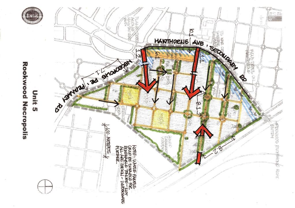
15 Management Unit 5 - Anglican Description: Post s burial in modified grid- simpler pattern to Edwardian burials of earlier Anglican areas. Bunya & Hoop pines, Date/Canary Is palms punctuate the grid. Part is located on Hawthorne Ave ridge with panoramic views to CBD. Desired Future Character: Views to east retained to CBD, Axial pattern of circulation routes defined by palm/pine/tree planting retained and reinforced. Alignment of Railway interpreted. KEY MANAGEMENT PRIORITIES: Cemetery Purposes- burial in areas to be identified, intensification of use, re- use and renewal schemes. SD 1 Adopt sustainable management practices P12 Identify opportunities for burial, renewable tenure and renewal schemes whilst maintaining Rookwood values (heritage, social, visual, vegetation) subject to legislation: 12.1 Exclude the areas identified as representative of social/ religious burial Any renewable tenure to follow the grid layoutcurrent circulation patterns Investigate if any circulation routes could be closed and used for burial Avoid isolated infill to reduce conflicts if entire areas of renewable tenure are proposed Explore natural burial within the regenerated woodland at the eastern edge of the Unit. SD 2 Protect Rookwood s heritage and conserve its environment P 1 Maintain Visual Corridors: 1.1 Maintain views east from Hawthorne Ave to the CBD skyline. 1.2 Maintain views to CBD skyline east from Merchant Navy area. 1.3 Maintain views along axis circulation paths as representative of grid cemetery plan. P 2 Maintain Historic Circulation Routes including setting and material fabric: 2.1 Maintain grid circulation paths, including defining trees as continuation of the principles of Pearce and Maiden. P6 Interpret significant heritage features and/or heritage items no longer present: 6.1 Interpret the site of the railway reversing area on ridge adjacent Necropolis Dr- in accordance with heritage guidelines. P7 Implement and reinforce established street hierarchy- primary, secondary, tertiary: 7.1 Maintain the existing characteristics of Necropolis Drive (Primary Road) on the southern edge of Unit 5- Trees (E. microcorys) to be protected and replaced when required to maintain avenue- RNT. 7.2 Establish tree planting and profiles of the Secondary Road- Hawthorne Avenue. P8 Maintain significant trees/vegetation/ botanical items of rarity- refer Significant Tree Register and threatened species: 8.1 Maintain Bunya and Hoop pines, Date and Canary Is palms- continue management & replacement program. 8.2 Maintain and reinforce boundary planting along Graham Ave and railway embankment. 8.3 Protect all Threatened species- refer PMP.
16 Management Unit 5 - Anglican P9 Maintain historic serpentine and canal: 9.1 Maintain drainage functions of gully on the eastern boundary of the Unit. P 10 Recognise high points and ridgelinesvisually prominent areas: 10.1 Protect the ridgeline on Hawthorne Ave- special consideration in design of any structures. Adhere to architectural guidelines. SD 4 Respect cultural diversity and equitable allocation of resources P11 Maintain representative examples of social/religious group burial practices: 11.1 Retain and protect areas identified in social mapping.
17
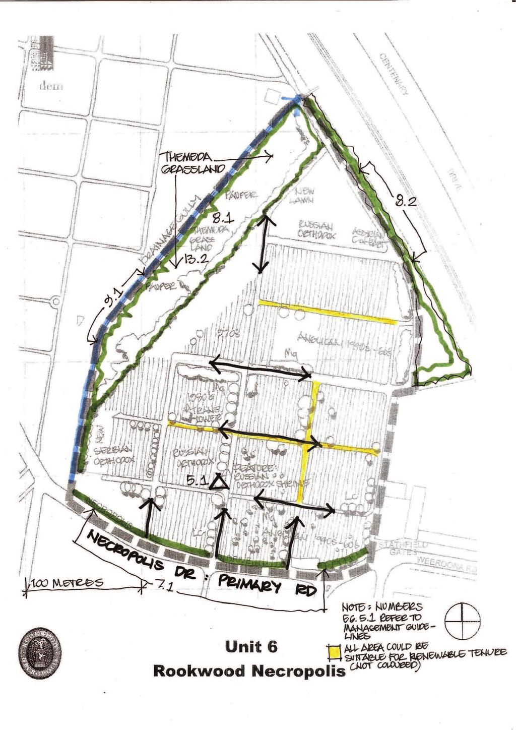
18 Management Unit 6 - Anglican, Russian/Serbian Orthodox Description: 1940 to post 1950 s burial, in grid layout. Russian Orthodox shrine is a focal point. Desired Future Character: Areas retained to represent social/religious burial of Russian, Serbian Orthodox faith. KEY MANAGEMENT PRIORITIES: Cemetery purposes - burial in areas to be identified, identification of intensification of use, re- use and renewal schemes. SD 1 Adopt sustainable management practices P12 Identify opportunities for burial, renewable tenure and renewal schemes whilst maintaining Rookwood values (heritage, social, visual, vegetation) subject to legislation: 12.1 Utilisation of the Unit for renewable tenure could occur, excluding the areas identified as representative of social religious burial practices. (identified in Social mapping study) 12.2 Areas that could be released for renewable tenure should follow the grid layout of the current circulation patterns - maintaining every second circulation road, burying in others Avoid isolated infill to reduce conflicts if entire areas of renewable tenure are proposed Explore natural burial whilst maintaining the Themeda grassland in current pauper burial area. P14 Maintain all above ground structures for maintenance of safety, visual and heritage values: SD 2 Protect Rookwood s heritage and conserve its environment P 1 Maintain Visual Corridors: 1.1 No important visual corridors exist in this Unit. P5 Maintain heritage monuments, features, landmarks of artistic, creative and technical value including their settings: 5.1 Maintain the Russian Orthodox Shrine as a social/visual landmark within the Unit. P7 Implement and reinforce established street hierarchy- primary, secondary, tertiary. 7.1 Maintain the existing characteristics of Necropolis Drive on the southern edge of Unit 6- Trees (E. microcorys) to be protected and replaced when required to maintain avenue. P8 Maintain significant trees/vegetation/ botanical items of rarity- refer Significant Tree Register and threatened species: 8.1 Maintain the Themeda grassland used for pauper burials as flora and fauna habitat. 8.2 Maintain and reinforce boundary planting along Graham Ave, railway embankment and Council depot. P9 Maintain historic serpentine and canal: 9.1 No historic serpentine or canal exists. Maintain drainage functions of drainage gully on the northern boundary of the Unit. SD 4 Respect cultural diversity and equitable allocation of resources P11 Maintain representative examples of social/religious group burial practices-areas identified in social significance study: 11.1 Retain and protect areas identified in social mapping.
19
20 Management Unit 7 - Mortuary Station No 1 site Description: State Heritage Register- Listed area. Central focus of Victorian Cemetery layout attributed to Charles Moore. Mortuary Station No. 1 completed in 1869-James Barnet Architect. Area includes lawn burial, columbarium, Jewish Martyrs Memorial. Prominent high point located on spur ridge, views afforded to and beyond the site. Desired Future Character: Heritage significance of this focal point respected in complimentary burial treatment. Current disjointed layout integrated better to reflect heritage significance. KEY MANAGEMENT PRIORITIES: Conservation as an historic site. Some Cemetery purposes- may be possible without compromising the area. SD 1 Adopt sustainable management practices P12 Identify opportunities for burial, renewable tenure and renewal schemes whilst maintaining Rookwood values (heritage, social, visual, vegetation) subject to legislation: 12.1 Unit is within SHR area but may be improved by consideration of renewable tenure, designed to complement the Unit s heritage significance Avoid isolated infill to reduce conflicts if entire areas of renewable tenure are proposed Explore natural burial whilst maintaining the Themeda grassland in current pauper burial area. P14 Maintain all above ground structures for maintenance of safety, visual and heritage values: SD 2 Protect Rookwood s heritage and conserve its environment P 1 Maintain Visual Corridors: 1.1 Maintain long views north and south along the previous railway alignment. 1.2 Maintain views into the Unit from each of the No. 1 areas surrounding. P 2 Maintain Historic Circulation Routes including setting and material fabric: 2.1 Maintain setting of Mortuary Station No.1 and reinforce connections with surrounding units. P3 Maintain landscape pattern of areas within State Heritage Register (SHR): 3.1 Protect historic circulation routes and connections with No.1 areas. P4 Maintain landscape design including influences of prominent individuals: 4.1 Protect and maintain design by Charles Moore, with no compromise of the circular form of this unit. P5 Maintain heritage monuments, features, landmarks of artistic, creative and technical value including their settings: 5.1 Maintain heritage structures including Mortuary Station, Station master s store. 5.2 Maintain Jewish Martyrs Memorial and consider context of external walls /setting P6 Interpret significant heritage features and/or heritage items no longer present: 6.1 Heritage items have been interpreted in this Unit. Consider additional interpretation of Mortuary Station to further represent railway context at Rookwood.
21 Management Unit 7 - Mortuary Station No 1 site P7 Implement and reinforce established street hierarchy- primary, secondary, tertiary. 7.1 Maintain established road hierarchy for Necropolis Circuit - primary road maintain tree planting (P. canariensis) and road profile. Implement management requirements of the palm study to ensure long term future of tree avenue. Tree management strategy to be undertaken. P8 Maintain significant trees/vegetation/ botanical items of rarity- refer Significant Tree Register and threatened species: 8.1 Maintain and progressively replace all significant trees according to results of significant tree study and management strategy. P 10 Provide special consideration to High points and ridgelines: visually prominent areas: 10.1 Allow the high point of this Unit to be read in the context of the Cemetery by retaining existing Mortuary interpretive structure on ridge and maintaining trees. Consult guidelines for ridgelines (to be prepared). SD 4 Respect cultural diversity and equitable allocation of resources P11 Maintain representative examples of social/religious group burial practices-areas identified in social significance study: 11.1 Retain and protect areas identified in social mapping.

22
23 Management Unit 8 - Presbyterian No. 1 Description: State Heritage Register- Listed area. Intact layout of circular and intricate burial pattern, vaults and heritage monuments. Frazer vault provides impressive focal point. Desired Future Character: Original landscape pattern of circular brick kerbs, gutters, cross patterns and tree planting retained. KEY MANAGEMENT PRIORITIES: Conservation as an historic site. Some Cemetery purposes- may be possible SD 1 Adopt sustainable management practices P12 Identify opportunities for burial, renewable tenure and renewal schemes whilst maintaining Rookwood values (heritage, social, visual, vegetation) subject to legislation: 12.1 The Unit is in SHR and is not generally suitable for renewable tenure. P13 Identify opportunities for development and additional burial space whilst maintaining Rookwood wide values (heritage, social, visual, vegetation) 13.1 Few areas are suitable for further development in this Unit, however areas in the western portion could be investigated for potential. P14 Maintain all above ground structures for maintenance of safety, visual and heritage values. SD 2 Protect Rookwood s heritage and conserve its environment P 1 Maintain Visual Corridors: 1.1 Maintain the foreground internal views along the grassed circulation paths. 1.2 Maintain visual connection with Unit 7. P 2 Maintain Historic Circulation Routes including setting and material fabric: 2.1 Maintain curvilinear paths in scale, materials and landscape character. P3 Maintain landscape pattern of areas within State Heritage Register (SHR): 3.1 Protect historic circulation routes in entire area. P4 Maintain landscape design including influences of prominent individuals: 4.1 Maintain the pattern of intact fabric and highly articulated paths and planning of the Charles Moore Plan. P5 Maintain heritage monuments, features, landmarks of artistic, creative and technical value including their settings: 5.1 Protect and maintain historic vaults including the landscape planting and setting. 5.2 Protect all heritage monuments identified in heritage study- maintain inventory. 5.3 Maintain the spatial qualities and landscape context/setting of all vaults and burial areas including fencing and details of enclosures. P6 Interpret significant heritage features and/or heritage items no longer present: 6.1 Strengthen the visual connection with Unit 7, original Mortuary station site. P7 Implement and reinforce established street hierarchy- primary, secondary, tertiary. 7.1 Maintain Necropolis Drive, Necropolis Crt and Cohen Ave - primary roads- RNT to manage existing tree planting as part of a Tree management policy
24 Management Unit 8 - Presbyterian No. 1 P8 Maintain significant trees/vegetation/ botanical items of rarity- refer Significant Tree Register: 8.1 Maintain all trees according to results of Significant Tree study, particularly trees in area near Necropolis Circuit. P9 Maintain historic serpentine and canal: 9.1 Maintain canal in wet area, review drainage in lower area. P 10 Recognise high points and ridgelines: visually prominent areas: 10.1 Consult guidelines for ridgeline if undertaking activities in the high point - connection to Unit SD 4 Respect cultural diversity and equitable allocation of resources P11 Maintain representative examples of social/religious group burial practices: 11.1 Retain and protect areas identified in the social mapping study.

25

26 Management Unit 8A - General No. 1 Description: Not listed in the SHR, although a No. 1 area. Chinese pavilion provides Chinese cultural focal point. Area is sparsely marked with sandstone stelae and open in character. Desired Future Character: Alignment of the Railway spur identified and interpreted, Chinese pavilion protected. KEY MANAGEMENT PRIORITIES: Conservation as an historic site. Some Cemetery purposes- may be possible SD 1 Adopt sustainable management practices P12 Identify opportunities for burial, renewable tenure and renewal schemes whilst maintaining Rookwood values (heritage, social, visual, vegetation) subject to legislation: 12.1 The Unit may provide opportunities for renewable tenure and further development- investigate for potential. P14 Maintain all above ground structures for maintenance of safety, visual and heritage values. SD 2 Protect Rookwood s heritage and conserve its environment P 1 Maintain Visual Corridors: 1.1 Maintain views to the Chinese pavilion from Necropolis Circuit. Enclose views elsewhere. 1.2 Maintain visual connection with Unit 7. P 2 Maintain Historic Circulation Routes including setting and material fabric: 2.1 Maintain curvilinear paths to Chinese pavilion as more defined circulation routes. P3 Maintain landscape pattern of areas within State Heritage Register (SHR): 3.1 Protect historic circulation routes described in 2.1. P4 Maintain landscape design including influences of prominent individuals: 4.1 Maintain the circular pattern of the surrounding roads and internal circulation routes. P5 Maintain heritage monuments, features, landmarks of artistic, creative and technical value including their settings: 5.1 Protect and maintain Chinese pavilion and surrounding fabric. 5.2 Protect all heritage monuments identified in heritage study and monuments of families. P6 Interpret significant heritage features and/or heritage items no longer present: 6.1 Interpret the railway corridor and connection with Unit 7. P7 Implement and reinforce established street hierarchy- primary, secondary, tertiary. 7.1 Maintain the established road hierarchy for Necropolis Circuit, Farrer Ave- primary roads, and Barnet Ave- secondary road. Implement and manage tree planting avenues as part of road hierarchy. P8 Maintain significant trees/vegetation/ botanical items of rarity- refer Significant Tree Register: 8.1 Some native orchids are present in the area and should be protected.
27 Management Unit 9 - Catholic Description: Late 19 th to 20 th century burials in grid layout defined by tree lined streets. Brushbox, Canary Is palms and pines define areas with serpentine/canal draining the western slope. Vaults, stelae, slab and desk monuments. Desired Future Character: Palm/ tree planting, significant vegetation retained and reinforced. Brushbox avenue on Gilroy Ave, Canary Is palms on Freeman St protected and progressively reinstated where necessary. Canals protected and defined, axial views along circulation paths retained defining burial areas. KEY MANAGEMENT PRIORITIES: Cemetery Purposes- burial in areas to be identified, intensification of use, re- use and renewal schemes. Heritage Conservation SD 1 Adopt sustainable management practices P12 Identify opportunities for burial, renewable tenure and renewal schemes whilst maintaining Rookwood values (heritage, social, visual, vegetation) subject to legislation: 12.1 Areas suitable for renewable tenure may be available in the lawn burial and Early 20 th Century burial areas, area north of canal- investigate further. SD 2 Protect Rookwood s heritage and conserve its environment P 1 Maintain Visual Corridors: 1.1 Maintain the view corridors along the north-south and east- west circulation routes. 1.2 Maintain panoramic view from Barnet Ave northwest over the Unit and along the railway alignment. (Edge of Unit 9 and 13) 1.3 Maintain view from circular portion of Barnet Ave (high vantage point) to all areas beyond. P 2 Maintain Historic Circulation Routes including setting and material fabric: 2.1 Maintain the grid of circulation routes particularly the avenue of trees defining these routes. P5 Maintain heritage monuments, features, landmarks of artistic, creative and technical value including their settings: 5.1 Protect identified heritage monuments ( in accordance with heritage study) P6 Interpret significant heritage features and/or heritage items no longer present: 6.1 Strengthen the visual corridor of the Railway alignment on the eastern boundary of the Unit and within Unit 13. Define Trust boundary with Unit 13. P7 Implement and reinforce established street hierarchy- primary, secondary, tertiary. 7.1 Maintain Barnet Ave and Haslem Drive - secondary road and other tertiary roads within the Unit, including trees. 7.2 Maintain vegetated buffer zones between contrasting burial types and social groups. P8 Maintain significant trees/vegetation/ botanical items of rarity- refer Significant Tree Register and threatened species: 8.1 Maintain tree avenues along Gilroy Ave, Freeman Ave and Phoenix Palm avenue along southern canal- Replace when required as part of tree management strategy. 8.2 Maintain large Araucarias, Eucalyptus and other significant trees according to results of Significant tree study. 8.3 Reinforce and maintain boundary planting along East St- RNT.
28 Management Unit 9 - Catholic 8.4 Protect all Threatened species- refer PMP. P9 Maintain historic serpentine and canal: 9.1 Maintain canals in accordance with canal study. P 10 Provide special consideration to High points and ridgelines: visually prominent areas: 10.1 Consider planning on ridgeline along Barnet Ave and adjacent Unit 17 high point to ensure visually prominent area and views are not disrupted. SD 4 Respect cultural diversity and equitable allocation of resources P11 Maintain representative examples of social/religious group burial practices-areas identified in social significance study: 11.1 Retain and protect areas identified in social mapping.

29
30 Management Unit 10 - Independent Description: Late 19 th - early 20 th Century burials. Parts included elaborate circular patterned layout with vaults as central focal points. Modified grid layout to remainder. Desired Future Character: Protection and conservation of original landscape pattern of one segment in grid- including kerbs, gutters, cross patterns, tree planting and vaults KEY MANAGEMENT PRIORITIES: Cemetery Purposes- burial in areas to be identified, intensification of use, re- use and renewal schemes. Heritage Conservation to one segment of grid including John Paul Vault and John Dunmore Lang vault. SD 1 Adopt sustainable management practices P12 Identify opportunities for burial, renewable tenure and renewal schemes whilst maintaining Rookwood values (heritage, social, visual, vegetation) subject to legislation: 12.1 The Unit may be suitable for renewable tenure in areas of early 20 th Century slab and desk monuments- investigate further. SD 2 Protect Rookwood s heritage and conserve its environment P 1 Maintain Visual Corridors: 1.1 Maintain the middleground internal views along the north-south circulation paths. P 2 Maintain Historic Circulation Routes including setting and material fabric: 2.1 Maintain the curvilinear paths in scale, materials and landscape character. P3 Maintain landscape pattern of areas within State Heritage Register (SHR): 3.1 Protect landscape pattern in the vault area. P4 Maintain landscape design including influences of prominent individuals: 4.1 Maintain the pattern of intact fabric and highly articulated paths and planning of the vault area. P5 Maintain heritage monuments, features, landmarks of artistic, creative and technical value including their settings: 5.1 Protect and maintain the historic vaults in Unit including the landscape planting and setting. P7 Implement and reinforce established street hierarchy- primary, secondary, tertiary. 7.1 Maintain the established road hierarchy for Oliver Ave and Barnet Ave- secondary roads- establish road profile, plant and manage trees as part of a Tree management policy. P8 Maintain significant trees/vegetation/ botanical items of rarity- refer Significant Tree Register: 8.1 Maintain pines along Oliver Avenue and instigate replacement planting program. P9 Maintain historic serpentine and canal: 9.1 Maintain canal in south and west according to canal study. SD 4 Respect cultural diversity and equitable allocation of resources P11 Maintain representative examples of social/religious group burial practices-areas identified in social significance study: 11.1 Retain and protect vaults of political figures and persons of identity in accordance with social mapping.
10.10 Diamond Harbour Memorial Gardens Cemetery
 10.10 Diamond Harbour Memorial Gardens Cemetery Cemetery Character Diamond Harbour Memorial Gardens Cemetery was officially opened in May 2002. The cemetery is designed in terraces in accordance with the
Draft Eastern District Plan
 Draft Eastern District Plan Submission_id: 31238 Date of Lodgment: 13 Dec 2017 Origin of Submission: Online Organisation name: Turrulla Gardens Pty Ltd C/- Mecone Organisation type: Industry First name:
4.0 ANALYSIS AND ASSESSMENT OF COMPONENTS Kadlitpinna/Park 13/Rundle Park Assessment
 4.0 ANALYSIS AND ASSESSMENT OF COMPONENTS 4.1.11 Kadlitpinna/Park 13/Rundle Park Assessment KADLITPINNA: 706 Kadlitpinna/Park 13/Rundle Park Existing Planning / Development Plan Context No component in
WELCOME. Land North of STEVENAGE. We would like to thank you for attending our public exhibition today.
 WELCOME We would like to thank you for attending our public exhibition today. The purpose of this event is to share our proposals and hear your thoughts on our ideas. Members of the project team are on
4.0 ANALYSIS AND ASSESSMENT OF COMPONENTS Kuntingga/Park 7 + Barnguttilla/Park 8 Assessment
 4.1.5 Kuntingga/Park 7 + Barnguttilla/Park 8 Assessment KUNTINGGA + BARNGUTTILLA: 658 Kuntingga/Park 7 + Barnguttilla/Park 8 Existing Planning / Development Plan Context The olive (Olea europaea) groves
Chapter 2: OUTLINE PLANNING APPLICATION PROPOSALS. A New Garden Neighbourhood Matford Barton 17
 Chapter 2: OUTLINE PLANNING APPLICATION PROPOSALS A New Garden Neighbourhood Matford Barton 17 2.1. SUMMARY AND STATUS OF THE PROPOSALS 2.1.1. The parameter plans and associated wording in this chapter
Fees for In-Ground Interment
 PO Box 291 Lidcombe NSW 1825 02 8575 8100 www.rookwoodcemetery.com.au Rookwood General Cemeteries Reserve Land Manager (ABN: 65 959 157 751) ees for In-Ground Interment Zone Section A C LAWN PERPETUAL
Page 1 of 19 URBAN DESIGN FRAMEWORK FOR BOLTON STREET WATERFORD
 Page 1 of 19 URBAN DESIGN FRAMEWORK FOR BOLTON STREET WATERFORD 1.0 Introduction: The relocation of the City Council stores and depot from Bolton Street creates an exciting opportunity for development
Public Consultation. Land at Monks Farm, North Grove. Welcome
 Welcome Welcome to our public exhibition for development on Land at Monks Farm, orth Grove. Gallagher Estates and Gleeson Strategic Land are preparing an outline planning application for new homes, open
Mollers Lane, Leopold, Victoria Significant Landscape Overlay Re-assessment
 XURBAN Mollers Lane, Leopold, Victoria Significant Landscape Overlay Re-assessment For: TGM Group November 2016 Final Mollers Lane, Leopold, Victoria Significant Landscape Overlay Re-assessment Client
Downtown Streetscape Manual & Built Form Standards
 City of Guelph Downtown Streetscape Manual & Built Form Standards July 2014 Prepared by Brook McIlroy Inc. in association with Unterman McPhail Associates and McCormick Rankin Inc. City of Guelph Downtown
Yorkshire Sculpture Park Historic Landscape Management Plan. Volume I. July 2010
 Yorkshire Sculpture Park Historic Landscape Management Plan Volume I July 2010 T: 01904 691630 www.landscapeagency.co.uk enquiries@landscapeagency.co.uk Contents 3 Volume I Historic Landscape Management
YONGE STEELES CORRIDOR SECONDARY PLAN. Young + Wright / IBI Group Architects Dillon Consulting Ltd. GHK International (Canada) Ltd.
 Ltd.") PART A: PREAMBLE 1.0 PURPOSE The purpose of this Secondary Plan is to provide a development framework for intensification of the Yonge/ Steeles corridor including the north side of Steeles Avenue West
PART A: PREAMBLE 1.0 PURPOSE The purpose of this Secondary Plan is to provide a development framework for intensification of the Yonge/ Steeles corridor including the north side of Steeles Avenue West
APPENDIX 9 HERITAGE CHARACTER
 APPENDIX 9 HERITAGE CHARACTER Defining attributes and features Perth Official Plan Appendix 9 HERITAGE CHARACTER defining attributes and features This appendix includes a table describing heritage attributes
Urban Design Brief Woodland Cemetery Funeral Home 493 Springbank Drive
 Urban Design Brief Woodland Cemetery Funeral Home The Incorporated Synod of the Diocese of Huron April 15, 2016 Urban Design Brief April 15, 2016 TABLE OF CONTENTS Page No. INTRODUCTION... 1 SECTION 1
Peckham Peckham Area Vision Map
 Area Vision Map PNAAP13 PNAAP8 Sumner Road Surrey Canal Walk Bird in Bush Park Key: NSP Site Allocations PNAAP Allocations Greenspace Low Line Cycle Network Primary Shopping Areas Square Surrey Canal Walk
Eastern Golf Course, Doncaster Road, Doncaster
 , 463-535 Road, Heritage Assessment in accordance with Schedule to the Development Plan Overlay July 2013 bryce raworth conservation urban design 19 Victoria Street St Kilda Vic 3182 , 463-535 Road, Heritage
Lancaster Conservation Area Appraisal. Character Area 8. Cathedral
 Lancaster Conservation Area Appraisal Character Area 8. Cathedral March 2013 118 3.8 Character Area 8. Cathedral 3.8.1. Definition of Special Interest "This character area is distinctive for the fine group
Appendix 1: Site Inventory Form
 Appendix 1: Site Inventory Form Wapsi Valley Archaeology, Inc. Anamosa, IA 56 X Cemetery Washington 83 24 2 NE X 1 5 approx. 200 approx. 201 unknown unknown Historic Resources Evaluation: 07A: Cemetery
GREENBANK DEVELOPMENT MASTERPLAN
 DEVELOPMENT MASTERPLAN POTENTIAL TRAIN STATION COMMUNITY CENTRE Greenbank will be a connected masterplanned community providing easy access to local and surrounding amenity. Affordable quality homes, green
Central City District What we heard
 What we heard Vision to 2056 and Priorities Governance and implementation Infrastructure and funding The vision for a metropolis of three cities, and the 30 minute city. Feedback requested: Clearer communication
Tauranga City Centre Spatial Framework
 Tauranga City Centre Spatial Framework Stakeholder Engagement Workshop 15 October 2015 Project Design Team Beca & LandLAB Our team Henry Crothers (LandLab) Landscape Architect/Urban Designer Urban and
Background Information
 Background Information view at site entrance THE LONDON BOROUGH OF SUTTON As the strategic local authority the Council is working with a range of partners to take forward various development sites in Hackbridge.
INCREMENTAL CHANGE AREA REVIEW March 2015 Page 1
 INCREMENTAL CHANGE AREA REVIEW March 2015 Page 1 Table of Contents Introduction... 3 Background to Review... 3 Comparison of the Schedules to the General Residential Zone... 7 Methodology... 7 Policy Context...
Kibworth Harcourt. Introduction. Introduction
 Introduction Introduction Welcome to this public exhibition on the proposals for the delivery of new homes on land at The Kibworths. The purpose of today s exhibition is to give you the opportunity to
Tāhuhu whakaruruhau ā-taone The sheltering ridge pole
 B2. Tāhuhu whakaruruhau ā-taone - Urban growth and form B2.1. Issues Tāhuhu whakaruruhau ā-taone The sheltering ridge pole Auckland s growing population increases demand for housing, employment, business,
URBAN DESIGN BRIEF NORTHVIEW FUNERAL HOME HIGHBURY AVE N, LONDON, ON
 URBAN DESIGN BRIEF NORTHVIEW FUNERAL HOME - 1490 HIGHBURY AVE N, LONDON, ON 1.1Purpose The intent of the following report is to identify an opportunity for redevelopment of two residential properties within
B4. Te tiaki taonga tuku iho - Natural heritage
 B4. Te tiaki taonga tuku iho - Natural heritage Tuia I runga, tuia i raro, tuia ki te waonui a Tiriwa Bind the life forces of heaven and earth to the great realm of Tiriwa B4.1. Issues Auckland s distinctive
Huddersfield Urban Design Framework. 3. Framework
 3. Framework The illustrative plan has been used as the basis for developing an urban design framework and strategy in Part 3 of this report. This is based on a series of regulatory plans that code the
22.15 OUTDOOR ADVERTISING SIGNAGE POLICY
 22.15 OUTDOOR ADVERTISING SIGNAGE POLICY This policy applies to all land where a planning permit is required to construct or display a sign under the provisions of the Kingston Planning Scheme. 22.15-1
South District What we heard
 What we heard Vision to 2056 and Priorities Governance and implementation Infrastructure and funding Feedback supported: The vision for a metropolis of three cities, but emphasised the importance of infrastructure
2bPlanning Scheme. Appendix. Conservation - Removal of Structures. Grangegorman
 Appendix 2bPlanning Scheme Grangegorman Conservation - Removal of Structures Innovative Urban Quarter Contemporary Healthcare Facilities Modern Education Hub Accessible Public Spaces Appendix 2b: Purpose
PLACE WORKSHOP REPORT. A+DS SNH sustainable placemaking programme
 PLACE briefing WORKSHOP REPORT A+DS SNH sustainable placemaking programme INTRODUCTION This report summarises the outcome of a Scottish Natural Heritage workshop on placemaking which was held on Wednesday
A. The sites in Table 16 below, as identified on the Policies Map, are allocated for retail-led development:
 SWDP 44: Worcester City Centre A. The sites in Table 16 below, as identified on the Policies Map, are allocated for retail-led development: Table 16: Sites Allocated for Retail-Led Development Policy Reference
Droitwich Spa 6. Reasoned Justification
 87 Droitwich Spa 6 Reasoned Justification 6.1 Droitwich Spa is identified in the settlement hierarchy (Policy SWDP1) as a main town being the largest settlement in Wychavon District with an estimated population
Babergh and Mid Suffolk Joint Draft Local Plan Consultation, August 2017, Public Consultation
 Babergh and Mid Suffolk Joint Draft Local Plan Consultation, August 2017, Public Consultation Having reviewed the documents, the Society has made the following response: Housing Delivery Q 7. Do you agree
COURTHOUSE CAMPUS BARNSLEY Executive Summary March 2010
 COURTHOUSE CAMPUS BARNSLEY Executive Summary March 2010 Estell Warren Cartwright Pickard Buro Happold King Sturge BWA Barnsley Metropolitan Borough Council introduction Courthouse Campus is the last major
Next Steps / Development Process. Structure Plan. June submitted to City of Fremantle. Structure Plan. July supported for advertising
 overview What is today about? In July 0, the City of Fremantle resolved that the be advertised for public comment. Today is about: Understanding the history and context of the site Having your say on the
5.0 P A R K R E C O M M E N D A T I O N S
 5.0 P A R K R E C O M M E N D A T I O N S 5.1 Confederation Park The analysis of Confederation Park recognizes that it, along with City Hall, is the symbolic heart of Kingston. While the existing layout
vision & process willowburn, tarves community engagement 04/18
 vision & process Historic Conservation area Scotia intend to create a high quality residential development based upon best practice urban design principles. This will include a contemporary reinterpretation
FEES AND CHARGES 2018
 IN-GROUND COIN INTERMENT EES AND CHARGES 2018 LAWN PERPETUAL LICENCE Zone Interment ee A Monumental Lawn C $8,265 $2,443 Presbyterian A and B* - $3,118* C Granite Lawns 1 and 2, Lawn 1* - $3,118* Lawn
Introduction. Welcome to this consultation regarding the draft redevelopment proposals for the former CeramTec factory on Sidmouth Road, Colyton.
 Introduction Welcome to this consultation regarding the draft redevelopment proposals for the former CeramTec factory on Sidmouth Road, Colyton. We are currently considering options for the mixed-use redevelopment
Development Brief Ursuline Convent, Blackrock, Cork
 Development Brief Ursuline Convent, Blackrock, Cork Comhairle Cathrach Chorcaí Cork City Council 2002 URSULINE CONVENT DEVELOPMENT BRIEF 1 INTRODUCTION AND MAIN OBJECTIVES... 3 1.1 The convent estate is
HISTORIC TEXAS CEMETERY REQUEST FOR DESIGNATION
 HISTORIC TEXAS CEMETERY REQUEST FOR DESIGNATION List additional descriptions or information on separate pages, if necessary. IDENTIFYING INFORMATION Primary name: Also known as: County: Type: Single grave
Plan Modification to Chapter B2 of the Auckland Unitary Plan(AUP) Operative in part (15 November 2016)
 Operative in part (15 November 2016)") UNITARY PLAN UPDATE REQUEST MEMORANDUM TO FROM Phill Reid Linley Wilkinson DATE 25 September 2018 SUBJECT Plan Modification to Chapter B2 of the Auckland Unitary Plan(AUP) Operative in part (15 November
UNITARY PLAN UPDATE REQUEST MEMORANDUM TO FROM Phill Reid Linley Wilkinson DATE 25 September 2018 SUBJECT Plan Modification to Chapter B2 of the Auckland Unitary Plan(AUP) Operative in part (15 November
Poolbeg West SDZ Draft Planning Scheme
 Poolbeg West SDZ Draft Planning Scheme Introduction/vision Housing Community Economy/Employment Movement/transport Infrastructure green infrastructure /open space Land-use and phasing Public Realm Urban
Newcourt Masterplan. November Exeter Local Development Framework
 Newcourt Masterplan November 2010 Exeter Local Development Framework Background The Exeter Core Strategy Proposed Submission sets out the vision, objectives and strategy for the development of Exeter up
L 4-1. Heritage Report: Reasons for Heritage Designation. Kodors House. 35 Rosedale Avenue West
 L 4-1 Brampton Heritage Board Date: January 17, 2012 Heritage Report: Reasons for Heritage Designation Kodors House 35 Rosedale Avenue West December 2011 1 L 4-2 Profile of Subject Property Municipal Address
Long Branch Neighbourhood Character Guidelines Final Report
 STAFF REPORT ACTION REQUIRED Long Branch Neighbourhood Character Guidelines Final Report Date: October 26, 2017 To: From: Wards: Reference Number: Etobicoke York Community Council Director, Community Planning,
8.3 Sector 4 Brooklyn Hills
 8.3 Sector 4 Brooklyn Hills Wellington Town Belt on the Brooklyn Hills between Mt Cook and Brooklyn 8.4.1 Character and use This sector extends around the city-facing slopes below Brooklyn, from Mortimer
4.3 Dudley Area Plan. Introduction. History and Existing Character. Desired Future Character for Dudley
 4.3 Dudley Area Plan Introduction The suburb of Dudley has developed as a result of various circumstances including its topography, history and mineral resources. Dudley development has been identified
STATEMENT OF OBJECTION TO THE PROPOSED DEVELOPMENT OF LAND AT CHURCH CLIFF DRIVE FILEY
 STATEMENT OF OBJECTION TO THE PROPOSED DEVELOPMENT OF LAND AT CHURCH CLIFF DRIVE FILEY You will be aware that Scarborough borough council have adopted a new local plan that includes land at Church Cliff
The Proposed Auckland Unitary Plan (notified 30 September 2013)
") 3 Business zones Introduction There are 10 business zones in the Unitary Plan: City Centre Metropolitan Centre Town Centre Local Centre Neighbourhood Centre Mixed Use General Business Business Park Light
3 Business zones Introduction There are 10 business zones in the Unitary Plan: City Centre Metropolitan Centre Town Centre Local Centre Neighbourhood Centre Mixed Use General Business Business Park Light
Physical Structure. This historic image from 1882 emphasizes the dramatic topography that distinguishes Cornell s setting at the top of East Hill.
 Physical Structure The natural, agrarian and urban setting for Cornell s campus is a precious resource to protect and enhance. It has also shaped the physical structure of the campus. Buildings, roads
Historic England Advice Report 26 August 2016
 Case Name: Kingsland Castle Case Number: 1435892 Background Historic England has been asked to review the scheduling for Kingsland Castle. The land on which the monument lies is understood to be for sale.
WELCOME. Olney Road, Lavendon INTRODUCTION. The Site. The Application. The Need for Housing. A Sustainable Location LAVENDON TURVEY OLNEY ROAD
 0 WELCOME INTRODUCTION Gladman Developments Ltd have successfully invested in communities throughout the UK over the past 0 years, developing high quality and sustainable residential, commercial and industrial
4 RESIDENTIAL ZONE. 4.1 Background
 4 RESIDENTIAL ZONE 4.1 Background The residential areas within the City are characterised by mainly lowrise dwellings sited on individual allotments. Past architectural styles, settlement patterns and
Landscape Assessment CEUGP/SR9B
 Landscape Assessment CEUGP/SR9B TABLE OF CONTENTS 1 STUDY PHILOSOPHY... 3 2 GENERAL DESCRIPTION OF SITE... 4 3 LANDSCAPE THEMES... 8 TABLE OF FIGURES Table 1: Landscape... 5 Table 2: Landscape Themes...
3.3. Urban Structure Defining a New Hierarchy of Routes and Spaces >Images
 Section 3.0 I The Masterplan Framework 18 >Images Examples of high quality routes and spaces 3.3. Urban Structure The success of any masterplan lies in a clear definition of the future urban structure
11 February CAMPUS MASTER PLAN UPDATE Focus Group - Design Guidelines
 11 February 2016 CAMPUS MASTER PLAN UPDATE Focus Group - Design Guidelines AGENDA Introductions Planning Scope The 2004 Campus Plan Observations Design Guidelines - 2004 Plan SWOT Exercise Analysis Goals
Ordnance Street 110 Plan OS Lot 413 B202; parts of Lot 412 and portion of Lot 413
 Ordnance Street 110 Plan OS Lot 413 B202; parts of Lot 412 and portion of Lot 413 110 Ordnance Street has cultural heritage value under 3 categories Physical built in 1886, it is an example of late 19
Cotswolds AONB Landscape Strategy and Guidelines. June 2016
 Cotswolds AONB Landscape Strategy and Guidelines June 2016 Cotswolds AONB Landscape Strategy and Guidelines Introduction The evolution of the landscape of the Cotswolds AONB is a result of the interaction
ILLUSTRATIVE MASTERPLAN
 ILLUSTRATIVE MASTERPLAN The Development Dairy Crest (Imperial College) The Proposed Development aims to create a new high quality residential neighbourhood, alongside a new public park for White City.
Warren Farm, Ampthill
 1 Welcome The developers of the Warren Farm site, Bloor Homes and Connolly Homes, are holding this exhibition on the emerging Design Codes for the development prior to their formal submission to Central
CENTENNIAL PARKLANDS CONSERVATION MANAGEMENT PLAN: VOLUME
 1.0 INTRODUCTION 1.1 Background Centennial Parklands was listed on the NSW State Heritage Register in March 2000. The listing recognises that Centennial Parklands is of particular significance to New South
CITY OF MIAMI CEMETERY 1800 N.E. 2 AVENUE
 CITY OF MIAMI CEMETERY 1800 N.E. 2 AVENUE Designation Report City of Miami REPORT OF THE CITY OF MIAMI PLANNING DEPARTMENT TO THE HERITAGE CONSERVATION BOARD ON THE POTENTIAL DESIGNATION OF CITY OF MIAMI
Daniels Park Master Plan
 Daniels Park Master Plan Prepared for: Douglas County & The City and County of Denver October, 2007 EXHIBIT A Contents Daniels Park Overview 2 Project History & Goals 2-3 Regional Context Map 4 Park Zone
Western City District What we heard
 What we heard Vision to 2056 and Priorities Governance and implementation Infrastructure and funding The protection of the natural landscape including biodiversity and the Metropolitan Rural Area for food
RURAL ZONE - POLICY. Rural Zone Policy. Issue: Rural Environment. Ruapehu District Plan Page 1 of 8
 Rural Zone Policy RU2 RURAL ZONE - POLICY RU2.1 Introduction The natural resources of the rural environment in the Ruapehu District provide the basis for the existing and potential character, intensity
3. STATEMENTS OF DESIRED CHARACTER FOR PLANNING AREAS AND PRECINCTS
 3.30 Planning Area No. 30 Mary River Valley 3.30.1 Location and Role This Planning Area encompasses rural lands in the western part of the Shire. These lands are located within the catchment area of the
GUIDELINES WESTON LOCATION: URBAN DESIGN GUIDELINES
 Development in the Weston area will be consistent with the following urban design guidelines. The guidelines correspond to Site and Area Specific Policies 45, 46, 47, 48, 49, 51, 52 and 232 in Chapter
PART 5: DEVELOPMENT FRAMEWORK Figure 57: Proposed Height
 Figure 57: Proposed Height 103 Figure 58: Proposed Land Use 104 Figure 59: 3D Image of the Initial Height and Land Use in the Study Area 105 4.3.2 Landmarks and Nodes The growth of Sandton from an out
FUNDAMENTAL BUILDING BLOCKS
 FUNDAMENTAL BUILDING BLOCKS THE WEB OF GIBSONS - EXISTING Lacks Community Structure and Support Circulation, surface water flow and buildings are disjointed from the community Social neighbourhoods are
DAREBIN PLANNING SCHEME AMENDMENT C137
 Who is the planning authority? Planning and Environment Act 1987 DAREBIN PLANNING SCHEME AMENDMENT C137 EXPLANATORY REPORT This amendment has been prepared by the Darebin City Council, who is the planning
LEEDS SITE ALLOCATIONS PLAN MATTER 3 GREEN BELT KCS DEVELOPMENT AUGUST 2017
 LEEDS SITE ALLOCATIONS PLAN MATTER 3 GREEN BELT KCS DEVELOPMENT AUGUST 2017 Smith Limited Suite 9C Joseph s Well Hanover Walk Leeds LS3 1AB T: 0113 2431919 F: 0113 2422198 E: planning@peacockandsmith.co.uk
4. MASTERPLAN FRAMEWORK
 6a 6b 4. MASTERPLAN FRAMEWORK 6. Car Parks 6c Car Parks 6a and 6b will provide permanent parking. Area 6a will serve the foodstore with tarmac surfacing within a defined area to the west of the adjacent
DRAFT GREATER SYDNEY REGION PLAN OBJECTIVES, STRATEGIES AND ACTIONS
 Greater Sydney Commission DRAFT GREATER SYDNEY REGION PLAN OBJECTIVES, STRATEGIES AND ACTIONS Issued: 26 OCTOBER 2017 Version: 1 Subject: Greater Sydney Region and District Plans This information note
TIER ONE - CMI URBAN DESIGN OBJECTIVES
 TIER ONE - CMI URBAN DESIGN OBJECTIVES V I S I O N TO CREATE A MOTORWAY CORRIDOR THAT: makes a positive contribution to city-wide connectivity and the urban fabric of Auckland is visually stimulating and
ZONE 2 MANNING STREET PRECINCT DESCRIPTION
 ZONE 2 MANNING STREET PRECINCT DESCRIPTION The zone occupies a former shallow creek valley enclosed on the southern and western edges by ridgelines but open towards Iron Cove to the north. It contains
L 2-1 HERITAGE REPORT: REASONS FOR HERITAGE DESIGNATION. Cheyne Family Cemetery. Main Street South
 L 2-1 HERITAGE REPORT: REASONS FOR HERITAGE DESIGNATION Cheyne Family Cemetery Main Street South October 2013 L 2-2 PROFILE OF SUBJECT PROPERTY: Municipal Address Main Street South (Lot 14, Con 1, EHS)
5. Bankside and The Borough 5.1. Bankside and The Borough Area Vision
 5. 5.1. Area Vision 5.1.1. are: A globally significant central London business district which is home to international business headquarters; At the heart of the commercial and cultural life of the capital
Subarea 4 Indian Creek. Vision The combination of park networks and transportation amenities make Subarea 4 the greenest hub in the Corridor.
 indian creek 180 extends south from 101st Street to I-435. The I-435 and Metcalf intersection is one of the primary intersections in the Kansas City Metro Area. The area includes several residential neighborhoods
CAMPUS MASTER PLAN UPDATE
 13 April 2016 CAMPUS MASTER PLAN UPDATE Focus Group Landscape AGENDA What We Heard Review of Campus Observations & Analysis Campus Framework & Open Space Network Table-Top Exercise Landscape Guideline
CORPORATE REPORT. NO: R137 COUNCIL DATE: June 29, 2015 REGULAR COUNCIL. TO: Mayor & Council DATE: June 24, 2015
 CORPORATE REPORT NO: R137 COUNCIL DATE: June 29, 2015 REGULAR COUNCIL TO: Mayor & Council DATE: June 24, 2015 FROM: General Manager, Parks, Recreation and Culture FILE: 4100-01 SUBJECT: Surrey Centre Cemetery
GUIDELINES TORONTO GENERAL HOSPITAL LOCATION. INTRODUCTION Existing College Wing Buildings and Site Plan - Figure 1A and Figure 1B.
 GENERAL HOSPITAL Development in the south-east quandrant of University Avenue and College Street will be consistent with the following urban design guidelines. LOCATION Lands owned by the Toronto General
52: 2182 Lakeshore Road East, Horizons
 1. Description of Property Municipal Address Name (if applicable) Legal Description Location of Property Ownership Access Current Use Existing Designation General Description Priority Level 52: 2182 Lakeshore
CHAPTER 18 - Strategy Area: Dundry and River Valleys
 This south-eastern part of the Community Forest is a complex area with a wide variety of different landscapes close together, including the Chew Valley, the southern part of the Avon Valley and the eastern
3.0 Area-Wide Strategies 30
 3.0 Area-Wide Strategies 30 3.6 Tourism Strategy This section of the plan aims to develop and improve the tourism potential of the area. Strategic Context The City Plan outlines the potential of Cork to
Welcome. Site/11/04. Site/11/03. Proposed Site. 11,400 new homes needed in east Cambs
 Welcome Welcome to our consultation on our proposals for new homes on land north east of Soham Road, Fordham. Members of the project team are available to answer any questions you have and listen to feedback.
OKEFORD FITZPAINE NEIGHBOURHOOD PLAN
 OKEFORD FITZPAINE NEIGHBOURHOOD PLAN Dear Parishioner, The Neighbourhood Plan Project Team have prepared this leaflet to summarise the full Neighbourhood Plan document. It provides a summary of the Vision,
LANDSCAPE RESOURCE SURVEY
 LANDSCAPE RESOURCE SURVEY Campus Heritage Landscape Plan Eugene, Lane County, Oregon Spring 2007 n RESOURCE IDENTIFICATION & SUMMARY LANDSCAPE AREA NAME (cc) Historic name(s) none known campus plan designation
2.2.1 Scope of Preliminary Cultural Heritage Landscape Inventory
 Cultural Heritage Landscape and Policy Study Page 7 2.0 CULTURAL HERITAGE LANDSCAPE INVENTORY 2.1 Introduction As part of the City of Vaughan s Official Plan review and associated development of cultural
C176. Amendment C176 Riverdale Precinct Structure Plan List of Document Changes for Planning Panels Victoria. Version th November 2013
 C176 Amendment C176 Riverdale Precinct Structure Plan List of Document Changes for Planning Panels Victoria Version 1.0 18 th November 2013 Amendment C176 Riverdale Precinct Structure Plan List of Document
SUE ROSEN ASSOCIATES. Re: DA DA/485/2016. Thank you etc
 Re: DA DA/485/2016 Thank you etc I m an Epping based heritage consultant commissioned by the Epping Civic Trust to comment on the heritage aspects of the proposed development and on the reportage associated
PDA SUBMISSION: Queen s Wharf, Brisbane (DEV2017/846)
") PDA SUBMISSION: Queen s Wharf, Brisbane (DEV2017/846) Date:: 17 October 2017 Contact Officer: Jonathon Fisher Chief Executive Officer Email: heritage@nationaltrustqld.org Phone: 07 3223 6666 NATIONAL TRUST
PDA SUBMISSION: Queen s Wharf, Brisbane (DEV2017/846) Date:: 17 October 2017 Contact Officer: Jonathon Fisher Chief Executive Officer Email: heritage@nationaltrustqld.org Phone: 07 3223 6666 NATIONAL TRUST
ZONE 3 KIRKBRIDE ENTRANCE GARDEN AND EMBANKMENT TO KING GEORGE PARK
 ZONE 3 KIRKBRIDE ENTRANCE GARDEN AND EMBANKMENT TO KING GEORGE PARK DESCRIPTION The Kirkbride entrance garden is a designed Victorian parkland with a prominent public address to Balmain Road. The original
Colchester Northern Gateway Master Plan Vision Review Draft. July 2016
 Colchester Northern Gateway Master Plan Vision Review Draft July 2016 Contents Introduction 4 Context 8 Purpose of the Report 8 Strategic Position 9 Overview of the Process 11 2012 Master Plan Vision 12
Memo. B R A Y H e r i t a g e
 6 1 3. 5 4 2. 3 3 9 3 6 1 3. 5 4 9. 6 2 3 1 c a r l @ b r a y h e r i t a g e. c o m Memo To: Jennifer Murray, Windmill Development Corporation From: Carl Bray, Bray Heritage Date: Monday, June 5, 2017
edge of gas line corridor setback edge of gas line corridor aligned with Schlumberger building 37.0 m AOD 33.0 m AOD max
 7. Heights and Street Frontage: In accordance with the approved heights parameters, heights to along Western Access Road must respond to the existing low density character in this location. Heights are
ACADEMY AREA CONCEPT PLAN
 ACADEMY AREA Strip ling C hape l Roa d CONCEPT PLAN 7 S2 U Stripling 52 ROADWAYS AND PARKING: ADVENTURE PLAYGROUND AND SPRAYGROUND: Current roadways follow existing drives. It is recommended that the Folds