CITY OF SIMI VALLEY MEMORANDUM
|
|
|
- Sibyl Foster
- 5 years ago
- Views:
Transcription
1 AGENDA ITEM NO. 8B CITY OF SIMI VALLEY MEMORANDUM May 2, 2016 TO: City Council FROM: Department of Environmental Services SUBJECT: STATUS UPDATE REGARDING THE RIM OF THE VALLEY CORRIDOR SPECIAL RESOURCES STUDY STAFF RECOMMENDATION Receive a status update regarding the Rim of the Valley Corridor Special Resource Study and provide direction to staff to follow further legislative action on this study. CITY MANAGER S RECOMMENDATION The City Manager concurs with staff recommendation. BACKGROUND AND OVERVIEW The Consolidated Natural Resources Act of 2008 (P.L , May 2008) directed the National Park Service (NPS) to evaluate: (1) the suitability and feasibility of designating all or a portion of the area known as the Rim of the Valley Corridor as a unit of Santa Monica Mountains National Recreation Area (SMMNRA); and (2) the methods and means for the protection and interpretation of this corridor by the National Park Service, other federal, state, or local government entities or private or non-governmental organizations. The Rim of the Valley Corridor is described in legislation as the area generally including the mountains encircling the San Fernando, La Crescenta, Santa Clarita, Simi, and Conejo Valleys in southern California. The NPS initiated the special resource study in summer 2010 with a newsletter describing the study process and opportunities for the public to participate. Numerous meetings with agencies, elected officials, and organizations were held during this period and into After a period of public comment review, alternative revisions, and environmental analysis, the study team released the Rim of the Valley Corridor Draft Special Resource Study and Environmental Assessment for review and comment in April On the basis of comments received and professional judgement, the NPS selected an alternative that it determined is the most effective and efficient way to manage the natural, cultural, and recreation resources of the Rim of the Valley Corridor. The final documents and maps associated with the study can be viewed at P 23/4-16(klk)
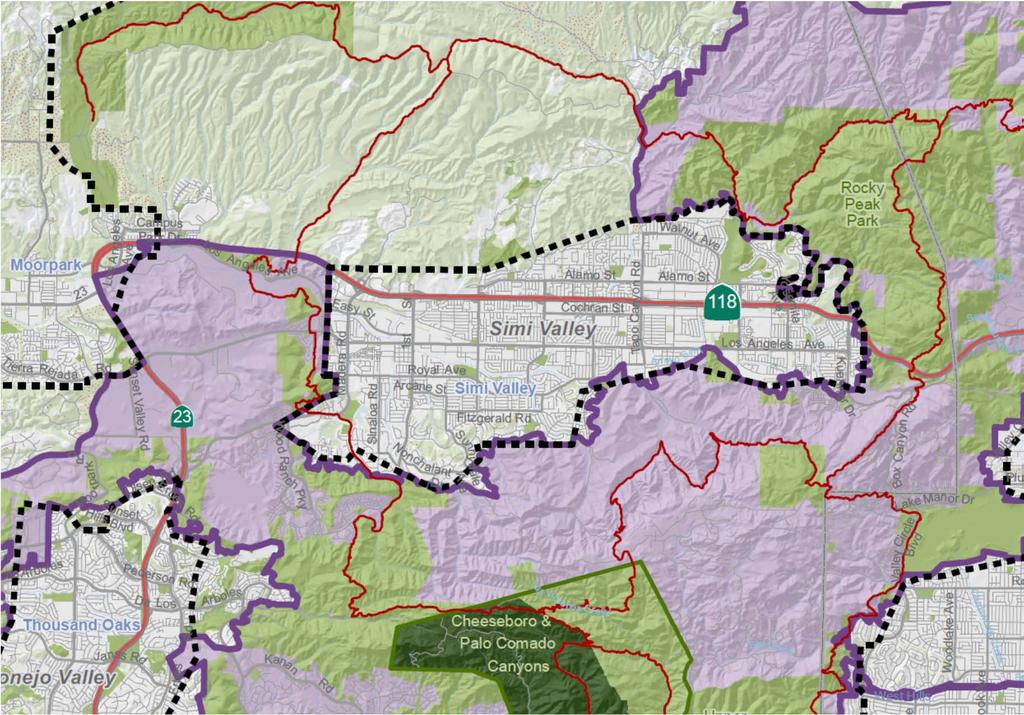
2 2 The selected alternative includes a 170,000-acre boundary adjustment to SMMNRA. The proposed boundary adjustment would add portions of the Los Angeles River and Arroyo Seco corridors, the Verdugo Mountains-San Rafael Hills, the San Gabriel Mountains foothills, the Simi Hills, the Santa Susana Mountains, and the Conejo Mountain area to SMMNRA. Existing parks such as Griffith Park, Hansen Dam Recreation Area, Sepulveda Basin (recreation areas and wildlife reserve), Los Encinos State Historic Park, Debs Park, El Pueblo de Los Angeles Historical Monument, and Los Angeles State Historic Park would serve as major portals into the Rim of the Valley Corridor area (Attachment A, page 5). The proposed boundary addition would provide recreational opportunities to a broad range of urban communities. Within the expanded area are: habitat types that contribute to the high biodiversity of the Santa Monica Mountains; functioning wildlife corridors; highly scenic landscapes; historic and archeological sites; geologic and paleontological resources; thousands of acres of open space and recreation areas; and miles of trails, all of which provide exceptional public enjoyment opportunities. Attached is a larger scale map showing areas around Simi Valley that are proposed to be included in the SMMNRA (Attachment B, page 6). The area shaded in purple is the selected alternative which includes the Simi Hills on the south side of the City as well as the Santa Susana Mountains east of Tapo Canyon Road. Within the City, areas of Wood Ranch, the Ronald Reagan Presidential Library, West Los Angeles Avenue, and Runkle Canyon are within the proposed boundary. At the east end of the City, Corriganville Park and Chumash Park are also within the proposed boundary. The Secretary of the Interior transmitted the final study to Congress on February 16, 2016 and the time for comment has been concluded. The attached NPS document summarizes the final study (Attachment C, page 7). Implementation of the selected alternative will require congressional legislation. In the absence of such legislation, the study remains a recommendation. Through legislation, Congress could authorize the NPS to manage the new additions as part of SMMNRA and explore partnerships with existing land management agencies, private landowners, and organizations. The NPS could then expend funds on resource protection, visitor services, land acquisition, and the planning and development of visitor facilities such as trails, waysides, etc. within the expanded NPS boundary. The NPS would also expand its capacity to provide technical assistance to agencies and organizations in the Rim of the Valley Corridor area with the intent of increasing outreach efforts to surrounding local communities. It should be noted that lands within the proposed boundary addition, unless purchased by, or donated to the NPS, would be subject to existing general plans and local zoning, as well as state and local laws and policies. Administratively, SMMNRA is a cooperative effort that joins federal, state, local park agencies with non-profit organizations and private landowners to protect resources and provide public enjoyment opportunities. P 23/4-16(klk)
3 3 While NPS shares responsibility for management of the national recreation area, it currently has direct responsibility for 15% of the land (23,500 acres). Approximately half of the lands within the national recreation area remain privately owned. In these areas local ordinances determine allowable uses on private lands. It is the understanding of staff that the proposed boundary adjustment would not affect private property or other valid existing rights, such as mineral rights. Within the SMMNRA boundary, the NPS only has authority to directly regulate lands under NPS ownership. Neither inclusion in the national recreation area, nor consideration of cooperative conservation approaches would impact local land use authority over lands not owned by the NPS. NPS policy is to acquire lands and interests in lands only from willing sellers. Support for the boundary adjustment has been previously expressed by neighboring jurisdictions. The Rancho Simi Recreation and Park District has supported the project as well as the Cities of Thousand Oaks and Moorpark. The expansion of the SMMNRA is viewed as a potential tool for encouraging the preservation of significant resources where appropriate. FINDINGS AND ALTERNATIVES The following alternatives are available to the City Council: 1. Receive and file a status update regarding the Rim of the Valley Corridor Special Resource Study and direct staff to follow any future legislative action on this study; 2. Receive and file a status update regarding the Rim of the Valley Corridor Special Resource Study Study; 3. Provide alternative direction to staff. Staff recommends Alternative No. 1. SUGGESTED CITY COUNCIL MOTION I move to receive the status update report regarding the Rim of the Valley Corridor Special Resource Study and direct staff to follow any future legislative action on this study. SUMMARY After extensive public review, the National Park Service has prepared a study regarding the benefits of expanding the Santa Monica Mountains National Recreation Area to include the Rim of the Valley Corridor, which is described in legislation as the area generally including the mountains encircling the San Fernando, La Crescenta, Santa Clarita, Simi, and Conejo Valleys in southern California. The selected alternative includes a 170,000-acre boundary adjustment to the SMMNRA. P 23/4-16(klk)

4 4 Portions of the Simi Hills and the Santa Susana Mountains around Simi Valley are within the selected alternative. The Secretary of the Interior transmitted the final study to Congress on February 16, Through legislation, Congress could authorize the NPS to manage the area as part of SMMNRA and explore partnerships with existing land management agencies, private landowners, and organizations. The NPS could then expend funds on resource protection, visitor services, land acquisition, and the planning and development of visitor facilities such as trails, waysides, etc. within the expanded NPS boundary. Within the SMMNRA boundary, the NPS only has authority to directly regulate lands under NPS ownership. Neither inclusion in the national recreation area, nor consideration of cooperative conservation approaches would impact local land use authority over lands not owned by the NPS. NPS policy is to acquire lands and interests in lands only from willing sellers. Peter Lyons, Director Department of Environmental Services Prepared by: Lauren Funaiole, Senior Planner INDEX Page Attachment A Selected Alternative Map... 5 Attachment B Map of Selected Alternative near Simi... 6 Attachment C Final Summary... 7 P 23/4-16(klk)
5 5 10 Miles 23 Conejo Valley Santa Clarita The NPS makes no warranty, express or implied, related to the accuracy or content of this map. Coordinate System: NAD 1983 UTM Zone 11N Santa Monica Mtns NRA 118 Santa Monica Mountains NRA GIS, February 2016 Data Sources: Existing protected areas and park boundaries: CPAD 9.1, NPS, USFS, SMMC, MRCA; Roads: Streetmap Pro 7; Trails: SMMC, USFS 0 Á Camarillo Simi Valley ty ou n sc e le ty n u o ra C ntu An g 126 Ve Lo s _ ^ Los Padres National Forest Santa Monica Mountains National Recreation Area Boundary Adjustment with Cooperative Conservation Emphasis Selected Alternative Santa Monica San Fernando Valley San Gabriel Mountains National Monument Santa Monica Mountains National Recreation Area Pasadena Pacific Crest Trail Other Federal, State, and Local Protected Areas Proposed Rim of the Valley Trail (USFS land is excluded from boundary adjustment) US Forest Service National Park Service 210 San Gabriel Mountains National Monument Existing Protected Areas (shading indicates boundary adjustment area) Study Area 14 Angeles National Forest Los Angeles Proposed Boundary Angeles National Forest National Park Service U.S. Department of the Interior 5 ATTACHMENT A
6 6 ATTACHMENT B B

7 National Park Service U.S. Department of the Interior 7 ATTACHMENT C Rim of the Valley Corridor Special Resource Study Final Summary February 2016

.")
8 8 Dear Friends, The National Park Service (NPS) is pleased to announce the completion of the Rim of the Valley Corridor Special Resource Study. The Secretary of the Interior transmitted the final study to Congress on February 16, This document summarizes the final study which includes the selected alternative recommended to Congress by the Secretary of the Interior and supported by the National Park Service determinations about the eligibility of the study area as an addition to Santa Monica Mountains National Recreation Area (SMMNRA). Selected Alternative The alternative recommended to Congress is a combination of alternatives C and D, a hybrid alternative that was selected based on public and stakeholder input and professional judgment of the NPS. The selected alternative is the National Park Service Director s most effective and efficient alternative for the long-term protection and public enjoyment of nationally significant resources in the Rim of the Valley Corridor. The selected alternative includes a 170,000-acre boundary adjustment to SMMNRA. The proposed boundary addition would provide recreational opportunities to a broad range of urban communities. Within the expanded area are: habitat types that contribute to the high biodiversity of the Santa Monica Mountains; functioning wildlife corridors; highly scenic landscapes; historic and archeological sites; geologic and paleontological resources; thousands of acres of open space and recreation areas; and miles of trails, all of which provide exceptional public enjoyment opportunities. In areas beyond the proposed boundary addition, SMMNRA would use existing authorities to partner and provide technical assistance to land managers and private landowners to maintain and enhance habitat connections to the Los Padres and Angeles national forests and to assist local communities in planning for recreational opportunities. Implementation of the selected alternative would require congressional legislation. In the absence of such legislation, the study remains a recommendation. Thank you for your involvement in the Rim of the Valley Corridor Special Resource Study. Sincerely, NPS Study Team Above: Coastal sage scrub vegetation. Photo: NPS. Cover photo: Oat Mountain area in the Santa Susana Mountains. Photo: Steve Matsuda. 2 Rim of the Valley Corridor Special Resource Study Final Summary February 2016
 directed the NPS to evaluate: (1) the suitability and feasibility of designating all or a portion of the area known as the Rim of the Valley Corridor as a unit of Santa Monica")
9 9 Introduction and Overview The Consolidated Natural Resources Act of 2008 (P.L , May 2008) directed the NPS to evaluate: (1) the suitability and feasibility of designating all or a portion of the area known as the Rim of the Valley Corridor as a unit of Santa Monica Mountains National Recreation Area (SMMNRA); and (2) the methods and means for the protection and interpretation of this corridor by the National Park Service, other federal, state, or local government entities or private or non-governmental organizations. The Rim of the Valley Corridor is described in legislation as the area generally including the mountains encircling the San Fernando, La Crescenta, Santa Clarita, Simi, and Conejo Valleys in southern California. The study was prepared following the process established by the National Park System New Area Studies Act (P.L , 16 U.S.C. Sec.1a-5). This law requires that special resource (new area) studies be prepared in compliance with the National Environmental Policy Act (NEPA) of 1969 (42 U.S.C ). The determination of whether any part of the study area qualifies as an addition or boundary adjustment to an existing unit of the national park system is based on criteria for boundary adjustments as described in NPS Management Policies 2006 (Section 3.5). The study legislation also requires the Secretary of the Interior to document the process used to develop the Santa Monica Mountains National Recreation Area Fire Management Plan and all activity conducted pursuant to the plan designed to protect lives and property from wildfire. This documentation can be found in the draft study report s Appendix G: Process Used to Develop the 2005 Santa Monica Mountains National Recreation Area Fire Management Plan and Environmental Impact Statement. This document summarizes the determination of the National Park Service (NPS) that resources evaluated through this study meet the criteria for a proposed boundary adjustment to the SMMNRA; the selection of the most effective and efficient alternative; and the determination that there are no associated significant impacts on the human environment. Study Area The study area covers approximately 650,000 acres in the southern California region. It includes SMMNRA (approximately 153,000 acres) and approximately 180,000 acres of lands managed by the U.S. Forest Service (the Angeles Rim of the Valley Corridor Special Resource Study Area Rim of the Valley Corridor Special Resource Study Final Summary February
. Middle row: California newt, Eupachydiscus sp.")
.")
.")
; and a second that focused on the potential creation of a new unit of the national park system.")


10 10 SMMNRA and the Rim of the Valley Corridor include a diverse range of significant natural and cultural resources. Top row: Rare Dudleya sp., coastal sage scrub, oak woodland, grassland (Photos: NPS). Middle row: California newt, Eupachydiscus sp. fossil, Burro Flats Painted Cave, Well No.4 Pico Canyon (Photos: NPS; Pico Canyon photo: Herald-Examiner Collection/Los Angeles Public Library). Bottom row: Gamble House stained glass, Santa Susana Field Laboratory rocket test stand, Jet Propulsion Laboratory (JPL) Space Flight Operations Center, Paramount Ranch filming (Photos: NPS; JPL photo: NASA). Study Findings The study included two analyses, one that focused on potential adjustment of the existing boundary of Santa Monica Mountains National Recreation Area (SMMNRA); and a second that focused on the potential creation of a new unit of the national park system. BOUNDARY ADJUSTMENT EVALUATION FINDINGS The study finds that the addition of lands in the study area to SMMNRA would enhance protection of significant resources and expand opportunities for public enjoyment related to the purpose of SMMNRA. Areas found eligible for addition to SMMNRA include: habitat types that contribute to the high biodiversity of the Santa Monica Mountains; functioning wildlife corridors; highly scenic landscapes; and archeological sites. Eligible areas also include geologic and paleontological resources, thousands of acres of open space and recreation areas, miles of trails, hundreds of sites of historical value, and national historic trails, all of which provide exceptional public enjoyment opportunities. Expanding SMMNRA to the east into the City of Los Angeles would provide new opportunities for the NPS to connect with communities in some of the most ethnically diverse and densely populated areas in the United States. Maintaining SMMNRA s habitat value and high biodiversity depends in part on functional habitat con- nectivity and protection of its broader ecosystem. A boundary adjustment to include the Rim of the Valley Corridor areas would provide the widest range of tools to maintain habitat connectivity and protect significant resources. The boundary adjustment would include the authority to inventory, monitor, and study resources, and to provide additional protection through targeted land acquisition. An adjustment to the boundary of SMMNRA is feasible using the collaborative partnership-based management model exemplified by existing SMMNRA management, which respects the complex mix of existing land use, ownership, and regulatory authorities within its boundary. Most feasibility factors (land use, access and public enjoyment potential, boundary size and configuration, public interest and support, social and economic impacts, and costs) could be met. NEW NATIONAL PARK UNIT CRITERIA ANALYSIS FINDINGS The creation of a new national park unit is less feasible when compared to the resource management and operational efficiencies afforded by adding areas to SMMNRA. Many of the significant resources within the study area augment the national significance of SMMNRA and provide the habitat connectivity essential for long-term preservation of the significant resources within the Santa Monica Mountains, thus warranting physical connection to SMMNRA and/or a seamless, collaborative management approach. 4 Rim of the Valley Corridor Special Resource Study Final Summary February 2016

11 11 National Forest and the recently established San Gabriel Mountains National Monument). Similar to SMMNRA, numerous agencies and conservation organizations manage lands within the study area. Portions of at least 27 communities are located in the study area, with approximately 5.1 million people living in the study area, and another 13 million living in surrounding communities within the greater Los Angeles metropolitan area. Land use is diverse and includes large natural areas, parks and recreation areas, suburban communities, farms and ranches, highly urbanized areas, freeways, and an array of public infrastructure. The vast majority of land, over 80%, is primarily undeveloped or vacant. After a period of public comment review, alternative revisions, and environmental analysis, the study team released the Rim of the Valley Corridor Draft Special Resource Study and Environmental Assessment (draft study report and EA) for review and comment in April Approximately three hundred participants, including elected officials and stakeholders, participated in six public meetings (including one virtual meeting via the Internet) and 1,800 comments were submitted online or by mail. On the basis of those comments and professional judgement, the NPS has since made necessary corrections to the draft study and selected an alternative that it believes is the most effective and efficient way to manage the natural, cultural, and recreation resources of the Rim of the Valley Corridor. Study Process and Public Involvement Alternatives Analyzed The study team conducted extensive public outreach throughout the study process and throughout the region. Four newsletters were published at various stages of the study process and distributed to the study mail and lists. All information sent by mail and has been available on the study website, Four alternatives were analyzed in the draft study report and EA and distributed for public review in April The NPS initiated this special resource study in summer 2010 with a newsletter describing the study process and opportunities for the public to participate. Seven public meetings were held during September and October Over 2,000 comments were accepted, and the study team published the results of the scoping process in a second newsletter. Numerous meetings with agencies, elected officials, and organizations were held during this period and into Throughout 2011 through 2012, the team worked with local recreation and land conservation agencies and resource experts to analyze the significance of the study area resources and develop preliminary alternative management concepts. In the fall of 2012, the study team presented draft alternative management concepts for public review in a newsletter distributed to over 3,000 individuals and organizations. The study team held seven public meetings at locations throughout the study area, as well as numerous meetings with local, state and federal government agencies, organizations, communities, and congressional offices. The team received and analyzed approximately 5,200 comments. Alternative A: Continuation of Current Management (No Action) served as a baseline for evaluating the action alternatives; Alternative B: Cooperative Conservation Partnership would foster cooperative planning and funding tools for the NPS, partner agencies and landowners in the Rim of the Valley Corridor and key habitat linkages to the Los Padres and Angeles national forests (no new areas would be added to SMMNRA); Alternative C: Rim of the Valley Boundary Adjustment, an approximately 173,000-acre addition to SMMNRA that would provide more parks and protect habitat linkages, with an emphasis on creating more recreational opportunities near urban areas; and Alternative D: Regional Rim of the Valley Boundary Adjustment and Cooperative Conservation Areas, an approximately 313,000 acre addition to SMMNRA with an emphasis on protecting regional wildlife corridors, would add most areas within Rim of the Valley Corridor (excluding U.S. Forest Service managed areas) to SMMNRA. Cooperative conservation approaches would also be recommended for key habitat linkages between the Rim of the Valley Corridor study area and the Los Padres and Angeles national forests. The study area generally includes the mountains encircling the San Fernando, La Crescenta, Santa Clarita, Simi, and Conejo Valleys. Photo: NPS. Rim of the Valley Corridor Special Resource Study Final Summary February
12 12 The Selected Alternative SMMNRA Boundary Adjustment with Cooperative Conservation Emphasis OVERVIEW SELECTED ALTERNATIVE DESCRIPTION (CONCEPT) The National Park Service special resource study process requires that the study identify the alternative or combination of alternatives that in the professional judgment of the NPS Director is most effective and efficient in protecting nationally significant resources and providing for visitor enjoyment. Based on public and stakeholder input and professional judgment, the NPS selected a hybrid alternative that is a combination of alternatives C and D. The National Park Service has determined that the selected alternative is the most effective and efficient alternative. The selected alternative includes a boundary adjustment to Santa Monica Mountains National Recreation Area (SMMNRA) and authority for NPS to provide technical assistance to surrounding local communities, agencies, and private landowners (if requested) to maintain habitat connectivity, protect key resources, and plan for new parks and trails. The boundary adjustment would provide recreational opportunities to a broad range of urban communities, including many that are underrepresented in national parks and underserved by state and local parks. The actions encompassed in the selected alternative are primarily the same as those identified and analyzed in alternative C (preferred alternative) in the environmental assessment, with the exception of minor modifications made as a result of information and comments derived from public review of the environmental assessment. The total acreage of the selected alternative is approximately 170,000 acres, similar to alternative C (173,000 acres). Relative to alternative C, the selected alternative: The proposed boundary adjustment would add approximately 170,000 acres to SMMNRA s authorized boundary. In areas beyond the proposed boundary addition, SMMNRA would use existing authorities to partner and provide technical assistance to land managers and private landowners to maintain and enhance habitat connections to the Los Padres and Angeles national forests and to assist local communities in planning for recreational opportunities. Adds approximately 52,000 acres of land considered in alternative D, including portions of the Conejo Mountain area, western Santa Monica Mountains, and western Simi Hills that contain important habitat connections to the Santa Monica Mountains. Includes the cooperative conservation approach for areas beyond the proposed boundary addition as proposed in alternatives B and D in the draft study report. Removes approximately 55,000 acres of land including: built-out, high density residential, commercial, and industrial areas on the periphery of the boundary adjustment; areas with landfills or other solid waste facilities; and areas with high concentrations of oil and gas production in the Santa Susana Mountains. These areas were removed to the degree possible, while retaining key resources and public enjoyment opportunities. Within the Los Angeles and Arroyo Seco river corridors, areas included in the revised boundary adjustment are focused on public rights-of-way and adjacent public lands. The historic areas in downtown Los Angeles remain in the boundary adjustment. The above modifications would not add to environmental impacts analyzed in the environmental assessment. The modifications, which reduce the amount of non-park (urban and developed) land in the boundary adjustment also would protect important habitat connectivity and benefit SMMNRA and the Rim of the Valley Corridor. The following is the full description of the selected alternative. PROPOSED AREA The proposed boundary adjustment would add portions of the Los Angeles River and Arroyo Seco corridors, the Verdugo Mountains-San Rafael Hills, the San Gabriel Mountains foothills, the Simi Hills, the Santa Susana Mountains, and the Conejo Mountain area to SMMNRA. Existing parks such as Griffith Park, Hansen Dam Recreation Area, Sepulveda Basin (recreation areas and wildlife reserve), Los Encinos State Historic Park, Debs Park, El Pueblo de Los Angeles Historical Monument, and Los Angeles State Historic Park would serve as major portals into the Rim of the Valley Corridor area (see Map: Selected Alternative). The selected alternative includes the areas with the highest concentration of resource values and public enjoyment opportunities in the study area. Areas with landfills or other solid waste facilities and high concentrations of oil wells in the Santa Susana Mountains that were considered as part of a boundary adjustment in the draft study report, are not included in the selected alternative. If at some point in the future, such areas are no longer used for these purposes, they could be considered for inclusion in the national recreation area. The proposed boundary adjustment would add approximately 170,000 acres to SMMNRA and would require congressional legislation for implementation. Approximately 41.5% of the 170,000-acre addition is currently protected by other land management agencies and organizations for purposes that include conservation, open space, and/or recreation. Angeles National Forest and San Gabriel Mountains National Monument lands are not included in the boundary adjust- 6 Rim of the Valley Corridor Special Resource Study Final Summary February 2016
13 5 10 Miles Santa Clarita The NPS makes no warranty, express or implied, related to the accuracy or content of this map. Coordinate System: NAD 1983 UTM Zone 11N Santa Monica Mtns NRA 118 Santa Monica Mountains NRA GIS, February 2016 Data Sources: Existing protected areas and park boundaries: CPAD 9.1, NPS, USFS, SMMC, MRCA; Roads: Streetmap Pro 7; Trails: SMMC, USFS 0 Á 23 Conejo Valley Simi Valley ty Camarillo 23 ou n sc e le ty An g ou n C a tu r Ve n Lo s _ ^ Los Padres National Forest Santa Monica Mountains National Recreation Area Boundary Adjustment with Cooperative Conservation Emphasis Selected Alternative Santa Monica San Fernando Valley 5 14 San Gabriel Mountains National Monument Santa Monica Mountains National Recreation Area Study Area Pasadena Pacific Crest Trail Other Federal, State, and Local Protected Areas Proposed Rim of the Valley Trail US Forest Service (USFS land is excluded from boundary adjustment) National Park Service 210 San Gabriel Mountains National Monument Existing Protected Areas Los Angeles Angeles National Forest (shading indicates boundary adjustment area) Proposed Boundary Angeles National Forest National Park Service U.S. Department of the Interior 13 Rim of the Valley Corridor Special Resource Study Final Summary February
14 14 ment. The National Park Service (NPS) and U.S. Forest Service would continue to explore partnership opportunities using existing authorities. The NPS recognizes that the proposed boundary adjustment would include hills and mountain systems beyond the Santa Monica Mountains and that Congress may consider revising the name of the broader national recreational area to better reflect the extent of the national park unit if a boundary addition is implemented. MANAGEMENT APPROACH Management by existing agencies, local governments, organizations, private landowners, and institutions described under the no action alternative would continue under the selected alternative. Agencies and local governments would maintain existing authorities and land management responsibilities. However, the NPS would become another partner in the management of an additional 170,000 acres within the study area. Cooperative conservation approaches would continue to be a component of the management approach for the proposed addition to SMMNRA. NPS Roles Through legislation, Congress could authorize the NPS to manage the new additions as part of SMMNRA and explore partnerships with existing land management agencies, private landowners, and organizations. The NPS could then expend funds on resource protection, visitor services, land acquisition, and the planning and development of visitor facilities such as trails, waysides, etc. within the expanded NPS boundary. NPS land acquisition would be targeted, with an emphasis on protecting significant resources, maintaining and enhancing habitat connectivity, and providing recreational opportunities. The NPS would only consider purchase of land from willing sellers. The NPS would also expand its capacity to provide technical assistance to agencies and organizations in the Rim of the Valley Corridor area with the intent of increasing outreach efforts to surrounding local communities. Beyond SMMNRA, NPS technical assistance could be provided for: natural resource protection and restoration, including protection of regional wildlife corridors and adjacent tributaries; trail and park planning; and to bring agencies, organizations, and landowners together to achieve common goals. Other Federal, State and Local Land Management Agencies and Organizations The NPS would work with local, state, and federal agencies to administer a cooperative land protection program and management framework. New planning efforts would explore opportunities for agencies to collaborate and set shared goals for resource protection, connecting parklands and trails, restoration objectives, and providing coordinated interpretive and educational opportunities that highlight nationally significant resources in newly added areas. The NPS would expand the cooperative management agreement with California State Parks, the Santa Monica Mountains Conservancy, and Mountains Recreation and Conservation Authority to provide coordinated management in the boundary addition. Through cooperative management agreements, the NPS, U.S. Forest Service, U.S. Fish and Wildlife Service, and Bureau of Land Management could explore new opportunities to leverage resources for protecting habitat linkages and providing visitor services. Local Land Use and Regulatory Authorities Lands included in the proposed boundary addition would continue to be managed through a variety of public and private mechanisms by private landowners, federal, state and local agencies, universities, and organizations. In SMMNRA where the NPS has proprietary jurisdiction, lands not owned by NPS are typically regulated by local and state agencies or other federal authorities. In proprietary jurisdiction parks, the state government has not ceded the state s jurisdiction over the park area to the NPS. However, under the National Park Service Organic Act 1916, which established the National Park Service, the Secretary of the Interior has broad authority to establish regulations for certain activities, regardless of federal land ownership, within authorized national park unit boundaries. These regulations are found in Title 36 Code of Federal Regulations (CFR) Chapter 1. Lands within the proposed boundary addition, unless purchased by or donated to the NPS, would generally be subject to existing general plans and local zoning, as well as state and local laws and policies. In some cases, where activities must cross federally-owned lands such as for access roads, NPS regulations may apply. The NPS is authorized to provide comments on proposed projects within SMMNRA and the broader Santa Monica Mountains Zone (SMMZ). SMMNRA s 1978 authorizing legislation established the SMMZ which includes watersheds and canyon slopes associated with, but not formally included in SMMNRA, as well as the easternmost portion of the Santa Monica Mountains encompassing Griffith Park. Local and state agencies are responsible for land use regulations within this zone, but the NPS retains, by law, reviewing authority on projects involving federal funds, permits, or licenses that may affect the national recreation area. This authority was provided by Congress when the national recreation area was established to reduce downstream impacts on national recreation area resources when possible. NPS regulations that could pertain to activities on lands considered for addition to SMMNRA include regulation of mineral extraction and the exercise of nonfederal oil and gas rights per 36 CFR Chapter 1, Parts 9A and 9B. These regulations respect existing rights and are not intended to result in the taking of a property interest, but rather to impose reasonable regulations on activities which involve and affect federally-owned lands. Valid existing mineral rights would be retained. The regulations are designed to insure that activities undertaken pursuant to these rights are conducted in a manner consistent with the purposes for which the national park system and each unit thereof were created. Solid waste disposal sites, if located 8 Rim of the Valley Corridor Special Resource Study Final Summary February 2016

15 15 Beyond SMMNRA s boundary, NPS technical assistance could be provided for natural resource protection and restoration, for trail and park planning, and to bring agencies, organizations, and landowners together to achieve common goals. Photo: NPS. within the boundary, would be regulated under 36 CFR Chapter 1, Part 6. These regulations prohibit the operation of any solid waste disposal site, except as specifically provided for, and govern the continued use of any existing solid waste disposal site within the boundary of any unit of the national park system. Most areas with these types of existing land uses (mineral extraction, the exercise of nonfederal oil and gas rights, and solid waste disposal) have been excluded from the proposed boundary adjustment. A limited number of areas with those types of land uses that are located within the proposed boundary adjustment remain within it because of their importance for resource values and habitat connectivity. The extent to which such regulations would affect these land uses would be dependent on what is specified in the legislation authorizing the boundary expansion, and the nature of the activities. Access to valid existing rights to minerals would not be affected by inclusion in the boundary. Mining operations in expanded park areas are also subject to state and local laws, ordinances, and rules. The NPS would continue its longstanding practice of working with all other permitting entities to reduce duplication and maximize efficiencies. Legislation would be required to expand the SMMNRA boundary. It should be noted that through any resulting legislation, Congress has the final authority to make determinations about uses and regulations within a specific park unit, regardless of what is proposed in this study. For example, some national recreation areas are open to mineral leasing if specified resource protection and administrative objectives can be met. Privately Owned Lands Administratively, SMMNRA is a cooperative effort that joins federal, state, local park agencies with non-profit organizations and private landowners to protect resources and provide public enjoyment opportunities. While NPS shares responsibility for management of the national recreation area, it currently has direct responsibility for 15% of the land (23,500 acres). Approximately half of the lands within the national recreation area remain privately owned. In these areas local ordinances determine allowable uses on private lands. The ordinances provide a framework of policies and development standards that protects park resources and encourages compatible development. The proposed boundary adjustment would not affect private property or other valid existing rights, such as mineral rights. Within the SMMNRA boundary, the NPS only has authority to directly regulate lands under NPS ownership (with the exception of certain regulations as described above). Neither inclusion in the national recreation area, nor consideration of cooperative conservation approaches would impact local land use authority over lands not owned by the NPS. NPS policy is to acquire lands and interests in lands only from willing sellers, with condemnation as a means of last resort. In some cases Congress has expressly limited NPS land acquisition authorities. Any legislation, if crafted by Congress for the boundary addition, could expressly limit NPS land acquisition to lands for which there are willing sellers. Fire Protection Fire protection would remain the responsibility of existing federal, state, and local agencies (Los Angeles and Ventura Rim of the Valley Corridor Special Resource Study Final Summary February

16 16 counties, U.S. Forest Service, NPS, California Department of Forestry and Fire Protection), including assistance through cooperative fire agreements. NPS fire management practices such as brush clearing would only apply to land acquired by the NPS. See Appendix G, Process Used to Develop the 2005 Santa Monica Mountains National Recreation Area Fire Management Plan and Environmental Impact Statement in the draft study report for additional information on the SMMNRA fire management plan. Non-Governmental Organizations and Private Land Stewardship Water Supply, Flood Protection, and Other Infrastructure Facilities and Functions Non-Governmental Land Conservation. Non-governmental organizations would be part of the cooperative conservation planning effort and could work collaboratively with agencies and private landowners to help protect significant resources and critical wildlife corridors. Land trusts often work with private landowners to purchase conservation easements which maintain private ownership and use while providing compensation for land conservation. The greater Los Angeles metropolitan region has highly complex systems of public infrastructure related to telecommunications and energy, the transport and storage of local and regional water supplies (including recycled water), and infrastructure related to flood protection. In addition, numerous facilities are necessary to treat wastewater and manage solid waste. The selected alternative is not intended to affect existing public rights-of-way, water supply operations, water treatment operations, electrical or telecommunications infrastructure, or flood protection efforts. Management of water supply and treatment plants would continue under current authorities. The selected alternative would not affect existing or future water rights. The areas proposed for inclusion in the SMMNRA boundary are not intended to propose any new or future beneficial uses or requirements for water supply, water quality, or air quality regulations. The NPS would be required to regulate solid waste facilities per 36 CFR, Chapter 1, Part 6 in areas proposed for addition to SMMNRA. Such facilities have been excluded from the proposed boundary addition. Additionally, through any resulting legislation, Congress could make an exception to this regulation. The NPS would work cooperatively with non-governmental organizations and private landowners (upon request) to undertake cooperative conservation efforts that do not require federal land acquisition. These efforts could apply not only to areas in the proposed boundary adjustment, but also to cooperative conservation areas beyond the boundary that are important for wildlife movement and trail connections. Private Land Stewardship. Private land stewardship would continue to play a key role in the conservation of resources. Privately owned open space, whether undeveloped or in agricultural use, often provides habitat for wildlife and contributes to scenery. Some private lands have trail easements or rightsof-way for equestrian or other recreational activities. Additional options would include developer dedications, targeting federal and state incentive programs for private land conservation, and technical assistance from agencies and organizations for land conservation and habitat restoration. Local ordinances would continue to determine appropriate uses for private lands. Private land stewardship actions would be voluntary on the part of the landowner. RIM OF THE VALLEY TRAIL Various agencies and organizations would continue to develop proposed segments of the Rim of the Valley Trail. For example, the NPS and other state and local agencies are currently pre- In coordination with existing Los Angeles River initiatives, emphasis would be placed on creating more opportunities for recreation, interpretation and education along the Los Angeles River and its tributaries. Photo: NPS. 10 Rim of the Valley Corridor Special Resource Study Final Summary February 2016

17 17 paring a SMMNRA Interagency Trail Management Plan. The trail management plan will include proposals for existing and proposed alignments for the Rim of the Valley Trail system within the current SMMNRA boundary. Overall planning and implementation of the Rim of the Valley Trail would be supported by the NPS through technical assistance and partnership development. Planning would include careful coordination with existing agencies, organizations, and private landowners to ensure that trail alignments do not conflict with existing land uses and ownership. The NPS could develop and manage new segments of the Rim of the Valley Trail that cross NPS managed land within the expanded boundary of SMMNRA. Once established, the Rim of the Valley Trail would be eligible for designation as a national recreation trail, through the existing application process, which is voluntary and could be a cooperative management action initiated by trail managers. RECREATIONAL OPPORTUNITIES AND ACCESS Inclusion in the SMMNRA boundary would give NPS the authority to expend funds on creating new trails and other facilities where appropriate. As requested, and contingent on funding, the NPS would provide technical assistance to surrounding communities to enhance access to SMMNRA and other open space areas through trail connections and public transportation options and to increase the overall diversity of public parklands. In coordination with existing Los Angeles River initiatives, emphasis would be placed on creating more opportunities for recreation, interpretation, and education along the Los Angeles River and its tributaries, including the Arroyo Seco and Tujunga Wash. The NPS could develop partnerships with existing nature centers and recreational facilities to facilitate access and serve as local gateways to the broader Rim of the Valley Corridor area. Providing improved access and alternative transportation opportunities to existing recreational opportunities and parks would be explored, particularly for communities that lack adequate access to parks and open space. This could occur through expansion of existing NPS or park partner bus leasing contracts, or through coordination and cooperation with existing transit agencies. For example, the NPS and partner agencies could explore creating recreational linkages to the Orange Line, a major public transportation corridor which connects downtown Los Angeles with San Fernando Valley communities. The NPS would emphasize and promote the public health benefits of outdoor recreation. Children in communities that do not have adequate access to outdoor recreation tend to have higher rates of childhood diseases related to obesity, such as diabetes. Expanding SMMNRA into urban areas to the north and east would provide new close-to-home opportunities for The lands within the proposed boundary adjustment would provide new opportunities for educational and interpretive programs and more engagement of urban communities. Photo: NPS. those communities that do not have adequate access to parks and open space. The NPS would conduct outreach to local communities, organizations, and schools to promote opportunities to visit parks for healthy recreational activities. The NPS could also coordinate and collaborate with the U.S. Forest Service s Southern California Consortium to conduct outreach on recreational and learning opportunities with local schools and youth. EDUCATION AND INTERPRETATION The lands within the proposed boundary adjustment would provide new opportunities for educational and interpretive programs and more engagement of urban communities. The NPS would seek opportunities to coordinate interpretive and educational messaging and programs in partnership with existing agencies and organizations. Interpretive themes related to nationally significant resources throughout the Rim of the Valley Corridor area would be emphasized. With the Los Angeles River and its tributaries providing close-to-home physical and recreational connections, watershed interpretive themes could also be emphasized. Adding more cultural resources in downtown Los Angeles and other urban communities to the boundary would also provide opportunities to interpret the diverse cultural heritage of the region. Rim of the Valley Corridor Special Resource Study Final Summary February


18 18 The boundary adjustment would expand and enhance protection of significant resources already within SMMNRA. Studies have documented the importance of the wildlife corridor within the Simi Hills, the Conejo Mountain area, and the Santa Susana Mountains. Photos: NPS. Topics currently interpreted at SMMNRA such as film history and modern film production, Native American history and prehistory, and the significance of Mediterranean ecosystems would be expanded by the inclusion of new sites and resources that represent these themes. For example, the NPS currently interprets film history and film production at Paramount Ranch within SMMNRA. With the proposed boundary expansion, Griffith Park and Corriganville Ranch, two important sites in film history would be added to SMMNRA and would augment interpretation of this theme. Beyond the boundary addition, the NPS could also use existing authorities to conduct outreach and educational programs in surrounding communities. NPS could also provide technical assistance to help partner agencies develop educational programming if it relates to resources and educational programming conducted in the expanded boundary. RESOURCE PROTECTION The boundary adjustment would add numerous natural and cultural resources to SMMNRA that would expand and enhance protection of significant resources already within SMMNRA, including portions of the Santa Monica-Sierra Madre wildlife corridor within the Simi Hills, the Conejo Mountain area, and the Santa Susana Mountains. Numerous studies have documented the importance of this corridor for wildlife movement. Also included are native grasslands, more oak woodland types, and habitat for a range of additional rare and sensitive species. The San Gabriel Mountains foothills included in the selected alternative contain alluvial fan sage scrub, a distinct and sensitive natural community that has adapted to the unique fluvial processes of the Los Angeles basin. The boundary adjustment would also include the Verdugo Mountains, more connections to Griffith Park, and remnant riparian areas along the Los Angeles River which are important ecological stepping stones between the Santa Monica and San Gabriel mountains. The boundary adjustment would include cultural resources related to space exploration and the Cold War that are located in the Arroyo Seco corridor and Simi Hills. Other historical sites that reflect the settlement and economic development of the region include Pico Well No.4 National Historic Landmark, portions of the Butterfield Overland Trail, the Arroyo Seco Parkway, Route 66, and El Pueblo de Los Angeles Historical Monument. Portions of the Simi Hills and the Santa Susana Mountains that would be included in the boundary addition also contain numerous archeological sites, including rock art examples not found in SMMNRA. Within the boundary adjustment area, the NPS would partner with stakeholders to develop a collaborative land protection program that includes both cooperative conservation planning tools and strategic land acquisition. The current inventory and monitoring program in SMMNRA would be expanded to the new areas and would inform decision-making for resource management. To further engage urban populations, the NPS could create a network of partners to develop natural and cultural resource management programs that would engage the public through expanded citizen science, volunteer programs, education, and interpretation. The NPS would use its full range of tools and authorities for resource protection including land acquisition inventorying and monitoring, and a variety of resource protection projects. The current inventory and monitoring program of SMMNRA would be expanded to include the new areas and would inform decision-making for resource management. Both within the expanded national recreation area and in areas beyond, the NPS could provide technical assistance in scientific study, restoration opportunities, and documentation of cultural and natural resources. SMMNRA would work with partners to develop a collaborative geographic database to support decision-making. More universities and other partners would be engaged to assist in building scientific knowledge to support decision-making. 12 Rim of the Valley Corridor Special Resource Study Final Summary February 2016
19 19 Priorities for Land Conservation In recent years, various agencies and park districts have acquired large areas of open space in areas such as the Verdugo Mountains, Simi Hills, and eastern Santa Susana Mountains. The NPS would work with these partners to identify common priorities for land conservation that would emphasize protecting and enhancing habitat connectivity between existing parks and open spaces. Other agencies and organizations within the added areas would likely continue to acquire lands for conservation and open space as permitted under existing authorities. The NPS would focus its own land acquisition on protection of core habitat areas in SMMNRA and in protecting nationally significant resources and wildlife corridors within the newly added areas. Having such areas within the SMMNRA boundary means that the NPS would have the authority to purchase lands for protection or expend funds on other means of land conservation. The NPS would also continue to collaborate regionally to share research and participate in strategies to protect important wildlife corridors beyond the SMMNRA boundary. Emphasis would be placed on private land stewardship and providing technical assistance to public and private landowners, as requested, to conserve these resources. Restoration Opportunities. In more developed areas, the NPS could contribute to restoration efforts that would enhance biodiversity and create more resilient biological systems. The NPS could actively support current restoration efforts on the Los Angeles River, Arroyo Seco, and Tujunga Wash. Opportunities could also be explored, in cooperation with other agencies and landowners, for the Arroyo Simi and Calleguas Creek. These efforts would provide excellent opportunities to restore riparian areas and enhance regional habitat connectivity. Cooperative Conservation. The NPS would also explore collaborative restoration efforts to conserve and enhance habitat linkages between the Santa Monica Mountains and other large conservation areas within the San Gabriel Mountains and the Sierra Pelona. The Consolidated Natural Resources Act of 2008 allows for the NPS to enter into cooperative and interagency agreements to protect natural resources. The NPS may also contribute financially to projects that protect wetlands, watersheds, and coastal resources if they also benefit park resources. For example, such funding could contribute to restoration projects on tributaries to the Los Angeles River that extend beyond the proposed boundary addition because these tributaries provide excellent opportunities for wildlife movement. Existing federal and state programs that provide financial incentives for private landowners to restore habitat could be leveraged to achieve restoration objectives. Federal and state agencies have established numerous incentive programs to assist private landowners in their conservation efforts. The NPS could help identify additional opportunities to leverage funding that could be used by private landowners to conserve or restore lands. Within the federal government, the U.S. Department of Agriculture and U.S. Department of the Interior (U.S. Fish and Wildlife Service) offer numerous programs targeted to assist private landowner conservation. Several examples of the available opportunities are discussed below. The U.S. Department of Agriculture s Wildlife Habitat Incentive Program provides both technical and financial assistance to landowners who want to develop and improve wildlife habitat on their agricultural land, nonindustrial private forest land, or tribal land. The Conservation Reserve Program (Farm Services Agency) funds farmland projects that provide vegetative cover, riparian buffers, and other resource conservation activities. Farmers who enter the program receive an annual rental payment of up to $50,000 per person per year for the land taken out of agricultural production. Fifty percent cost sharing is also available for implementing conservation plans. Conservation Reserve Program contracts last years. As of 2012, approximately 10,500 acres of farmland were converted to habitat under the Conservation Reserve Program in California. The U.S. Fish and Wildlife Service has a Partners for Fish and Wildlife Program that provides technical and financial assistance to private landowners who are willing to partner on habitat improvements for migratory birds, as well as other threatened and endangered wildlife. Existing state programs to conserve farmlands such as those authorized by California s Williamson Act can also support conservation objectives. The Williamson Act established an incentive-based conservation program to protect agricultural resources, preserve open space, and promote efficient urban growth patterns. The Williamson Act enrollment is voluntary, and an agency cannot require a landowner to enter into a contract as a condition of approval for any permit or project. Opportunities for technical assistance to conserve significant resources and wildlife habitat could also be facilitated through the three resource conservation districts (Antelope Valley, Santa Monica Mountains, and Ventura) that service the area. Cultural Resources Documentation and Protection The NPS would work collaboratively to document cultural resources within the newly added areas. Although comprehensive inventories have been completed of cultural resources in SMMNRA, for California State Parks, and recently for the City of Los Angeles, other portions of the proposed boundary addition are not as well documented. Additional inventories, documentation and mapping of cultural sites could be undertaken. Information about sensitive sites need not be released to the public; details and locations may need to be withheld to protect the resources. The NPS could facilitate the development of a network of cultural resources stakeholders including historical societies, institutions, and other organizations. This network could explore and make recommendations related to cultural resources protection and interpretation. Significant sites could be evaluated for listing in the National Register of Historic Places or designation as national historic landmarks. Such designations would help to document the his- Rim of the Valley Corridor Special Resource Study Final Summary February

20 20 torical, cultural and archeological significance of the area and could enhance funding and technical assistance opportunities. Many sites within the study area are important to Native American tribes and other organizations. Tribes, organizations and others could continue to work with public and private landowners and managers to protect sacred sites and archeological resources, and to obtain access or ownership of important sites for ceremonial, interpretive, and educational purposes. OPERATIONS AND MAINTENANCE Existing land managers would continue to operate and manage their land and facilities. NPS would be responsible for operations and maintenance of lands that it acquires. Through cooperative management agreements, the NPS would have the opportunity to share staff, facilities and funding with partner agencies, streamlining operational efficiencies. Existing staff at SMMNRA would contribute to operation of the expanded park area. However, additional staffing and expertise needed for the expanded area would include: Natural resource management staff (~2-4 FTE) - to conduct inventory and monitoring of resources and to provide technical expertise on conservation of wildlife corridors and habitat restoration in urban areas. Staff with expertise in cultural resources management (~1-2 FTE) - to document and manage the expanded scope of cultural resources within the newly added area. Outreach coordinator and interpretive rangers (~3-5 FTE) - to create and develop visitor programs. Law enforcement rangers (~2-4 FTE) - to protect resources and ensure a safe visitor experience. Maintenance and facilities management staff (~2-4 FTE) - would be required to care for any additional lands that the NPS would acquire and for any new facilities that the NPS would construct (trails, roads, etc.). Planning staff (~1-2 FTE) to provide expertise in land conservation tools and strategies, park and trail development, and community partnerships. SMMNRA would also work to expand its network of volunteers to assist in park operations and resource management activities in the newly added park areas. Volunteers for SMMNRA contribute many thousands of hours to all aspects of park management. SMMNRA and agency partners would also continue to rely on private fundraising through friends and partner groups such as the Santa Monica Mountains Fund. FUNDING AND COSTS Operational Costs Given NPS budget constraints, it is likely that the newly added areas would initially be supported by existing SMMNRA operational funding. Initially, new staffing needs would primarily be for park planning, outreach, and coordination with other agencies and organizations. Increased staffing for the expanded SMMNRA would happen incrementally over time as implementation planning specifies objectives and as the NPS acquires land. Following completion of a management plan that would identify more specific goals for land protection, resource management, facilities, education, and outreach, more detailed operational costs and staffing needs would be identified. The annual operating cost for SMMNRA was $8.6 million in fiscal year These operational costs primarily support staffing. SMMNRA would also leverage NPS sources of funding beyond the annual operating costs for planning efforts, specific resource management objectives, and for the construction of visitor facilities. The annual NPS operating budget for the expanded SMMNRA could range from $9.5-$10.5 million, an increase of $900,000-$1.9 million above SMMNRA s 2012 operating budget. The level of staffing needs would reflect the emphasis of future management (e.g. the amount and type of land acquired by NPS, ability to accomplish objectives through partnerships). Existing staff at SMMNRA would contribute to operation of the expanded park. However, additional staffing and expertise would be needed. SMMNRA would also work to expand its network of volunteers to assist in the newly added park areas. Photo: NPS. 14 Rim of the Valley Corridor Special Resource Study Final Summary February 2016
ADOPTION OF THE REVISED OPEN SPACE AND CONSERVATION ELEMENT OF THE GENERAL PLAN
 TO: FROM: SUBJECT: Honorable Mayor and City Council Planning Department ADOPTION OF THE REVISED OPEN SPACE AND CONSERVATION ELEMENT OF THE GENERAL PLAN RECOMMENDATION: It is recommended that the City Council:
Waco Mammoth Site Special Resource Study
 Waco Mammoth Site Waco, Texas Newsletter #2 August 2007 National Park Service U.S. Department of the Interior Waco Mammoth Site Special Resource Study We are pleased to share with you an update on the
3. VISION AND GOALS. Vision Statement. Goals, Objectives and Policies
 Vision Statement Queen Creek s interconnected network of parks, trails, open spaces and recreation opportunities provide safe and diverse activities and programs that sustain its unique, small town, equestrian
Improving Communities Through the Arroyo Seco Sustainability Campaign and Watershed Assessment
 Improving Communities Through the Arroyo Seco Sustainability Campaign and Watershed Assessment Arroyo Seco Headwaters in the San Gabriel Mountains Major tributary to the Los Angeles River 44 square mile
Chapter 5: Recreation
 Chapter 5: Recreation Introduction and Setting Recreational opportunities within Nevada County are varied, ranging from public parks with intensively used active recreational facilities, to vast tracts
FOREST SERVICE MANUAL NATIONAL HEADQUARTERS (WO) WASHINGTON, DC
 WASHINGTON, DC") Page 1 of 11 FOREST SERVICE MANUAL NATIONAL HEADQUARTERS (WO) WASHINGTON, DC FSM 2300 RECREATION, WILDERNESS, AND RELATED RESOURCE MANAGEMENT Amendment No.: 2300-2011-2 Effective Date: October 19, 2011
Page 1 of 11 FOREST SERVICE MANUAL NATIONAL HEADQUARTERS (WO) WASHINGTON, DC FSM 2300 RECREATION, WILDERNESS, AND RELATED RESOURCE MANAGEMENT Amendment No.: 2300-2011-2 Effective Date: October 19, 2011
STEWARDSHIP OF LONG ISLAND SOUND S ECOLOGICAL AND RECREATIONAL RESOURCES
 STEWARDSHIP OF LONG ISLAND SOUND S ECOLOGICAL AND RECREATIONAL RESOURCES Robin Kriesberg, Save the Sound, Inc. Thomas Halavik, US Fish and Wildlife Service Coastal Program An Initiative to Identify, Protect
I. STAFF POLICY RECOMMENDATIONS. The following RMP policy strategies are proposed by staff in support of a Scenic Resource Protection Program:
 Policy Consideration: Scenic Resource Protection Program Status: For Consideration by the Highlands Council at September 14, 2006 Work session Date: September 12, 2006 I. STAFF POLICY RECOMMENDATIONS The
TOWN OF BETHLEHEM OPEN SPACE CONSERVATION PLAN PUBLIC MEETING: OCTOBER 12, 2017
 TOWN OF BETHLEHEM OPEN SPACE CONSERVATION PLAN PUBLIC MEETING: OCTOBER 12, 2017 Welcome and Agenda 6:00 6:45: Open House, Part One 6:45 7:15: Presentation and Questions 7:15 8:00: Open House, Part Two
COASTAL CONSERVANCY. Staff Recommendation March 25, 2004 LOS ANGELES GREEN VISION PLAN. File No.: Project Manager: Marc Beyeler
 COASTAL CONSERVANCY Staff Recommendation March 25, 2004 File No.: 04-014 Project Manager: Marc Beyeler RECOMMENDED ACTION: Authorization to disburse up to $50,000 to the University of Southern California
The River Future. San Gabriel River Confluence with Cattle Canyon Creek Improvements Project (the Cattle Canyon Project)
") The River Future San Gabriel River Confluence with Cattle Canyon Creek Improvements Project (the Cattle Canyon Project) Collaboration Agency Leads Engaged Stakeholders Non-Profit Organizations USFS Pacific
The River Future San Gabriel River Confluence with Cattle Canyon Creek Improvements Project (the Cattle Canyon Project) Collaboration Agency Leads Engaged Stakeholders Non-Profit Organizations USFS Pacific
This page intentionally blank.
 This page intentionally blank. Parks, Recreation, and Open Space Chapter Relationship to Vision Vision Parks, Recreation and Open Space Chapter Concepts County Government. County government that is accountable
CITY OF SIMI VALLEY MEMORANDUM
 CITY OF SIMI VALLEY MEMORANDUM AGENDA ITEM NO. Consent (3) August 15, 2016 TO: FROM: City Council Department of Public Works SUBJECT: ADOPTION OF PLANS AND SPECIFICATIONS AND AUTHORIZATION TO SOLICIT CONSTRUCTION
City of Tacoma Planning and Development Services
 Agenda Item D-1 City of Tacoma Planning and Development Services To: Planning Commission From: Elliott Barnett, Planning Services Division Subject: Application #2014-08 Open Space Element Update Meeting
Member Service Plan Sierra Nevada AmeriCorps Partnership
 Member Service Plan Sierra Nevada AmeriCorps Partnership Service plans lay the framework for what each Member will be doing during their service. Service plans detail the major projects and expected results
ADOPTED CAPITAL IMPROVEMENT PROGRAM BUDGET ARROYO PROJECTS
 ADOPTED CAPITAL IMPROVEMENT PROGRAM BUDGET ARROYO PROJECTS HAHAMONGNA FY 212-216 Capital Improvement Program Priority Description Total Estimated Costs Appropriated Through FY 211 Adopted FY 212 FY 213
G. RECREATION AND OPEN SPACE ELEMENT. The following summarizes the Recreation and Open Space Element:
 G. RECREATION AND OPEN SPACE ELEMENT The purpose of the Element is to provide the framework and direction for a comprehensive system of public and private sites for recreation, including, but not limited
SUBJECT: Waterfront Hotel Planning Study Update TO: Planning and Development Committee FROM: Department of City Building. Recommendation: Purpose:
 Page 1 of Report PB-23-18 SUBJECT: Waterfront Hotel Planning Study Update TO: Planning and Development Committee FROM: Department of City Building Report Number: PB-23-18 Wards Affected: 2 File Numbers:
Plan Overview. Manhattan Area 2035 Reflections and Progress. Chapter 1: Introduction. Background
 Plan Overview The Manhattan Urban Area Comprehensive Plan (the Comprehensive Plan) is a joint planning initiative of the City of Manhattan, Pottawatomie County, and Riley County. The 2014 Comprehensive
OPEN SPACE CHAPTER 7: OVERVIEW. Preserve open space to protect natural resources, enhance character and provide passive recreation opportunities
 CHAPTER 7: OPEN SPACE OVERVIEW Ridgefield has made tremendous progress permanently preserving areas of town as open space. Open space preservation can serve many important purposes, including: protect
Rocky Areas Project Guidance HABITAT
 Rocky Areas Project Guidance HABITAT Introduction Rocky habitats are surface areas dominated by exposed rock, such as mountain peaks, inland cliffs, buttes and rocky outcrops. In many cases, rocky areas
Planning Commission Report
 Planning Commission Report To: From: Subject: Planning Commission Meeting: January 6, 2016 Agenda Item: 8-B Planning Commission David Martin, Planning & Community Development Director Introduction to the
Community Conservation Workshop. Saranac River Basin Communities
 Community Conservation Workshop Saranac River Basin Communities 2 Community Conservation Program Welcome! We have designed a Community Conservation Program that listens to the needs of community members.
ARROYO PROJECTS ADOPTED CAPITAL IMPROVEMENT PROGRAM BUDGET
 A RROYO P ROJECTS ADOPTED CAPITAL IMPROVEMENT PROGRAM BUDGET FISCAL YEARS 214-218 HAHAMONGNA Priority Description 1 Hahamongna Watershed Park - Implement Master Plan 211,6 211,6 (77565) 2 Hahamongna -
Arlington, Virginia is a worldclass
 EXECUTIVE S U M M A RY Arlington maintains a rich variety of stable neighborhoods, quality schools and enlightened land use policies, and received the Environmental Protection Agency s highest award for
Comprehensive Plan ADOPTED APRIL 2014
 Comprehensive Plan ADOPTED APRIL 2014 8 8. Outstanding Recreational & Cultural Opportunities We are proud of our community s parks and recreation system. Our community will ensure that the legacy of our
Central Lake Ontario Conservation Conservation Lands Master Plan
 Conservation Lands Master Plan Top 13 Frequently Asked Questions 1. What are conservation lands? Where are these conservation lands located in the Central Lake Ontario Conservation watershed? Conservation
Preserving National Historic Trail Settings Advancing the Principles of BLM Manual 6280
 Preserving National Historic Trail Settings Advancing the Principles of BLM Manual 6280 National Historic Trails Workshop Jeremy Call and Craig Johnson Logan Simpson Design October 2014 NTS Experience
San Diego River Coalition 2012 Work Plan
 San Diego River Coalition 2012 Work Plan Adopted November 18, 2011 The mission of the San Diego River Coalition is preserve and enhance the San Diego River, its watershed, and its natural, cultural and
Preservation of Scenery National Historic Trails. Rob Sweeten BLM Kevin Rauhe EPG
 Preservation of Scenery National Historic Trails Rob Sweeten BLM Kevin Rauhe EPG EPG Background Landscape architects with expertise in visual resources Resource staff includes: archaeologists, biologists,
Green Space, Recreation and Parks Master Plan
 Green Space, and Parks Master Plan Green Space, and Parks Master Plan s Summary Complete and implement the Pedestrian Master Plan that will enhance non-motorized transportation throughout Pasadena. Transportation
North Fair Oaks Community Plan Summary and Information
 North Fair Oaks Community Plan Summary and Information WHAT IS THE NORTH FAIR OAKS COMMUNITY PLAN? The North Fair Oaks Community Plan is part of the San Mateo County General Plan, and establishes policies
4. ENVIRONMENTAL IMPACT ANALYSIS 7. LAND USE AND PLANNING
 4. ENVIRONMENTAL IMPACT ANALYSIS 7. LAND USE AND PLANNING 4.7.1 INTRODUCTION The following analysis discusses the consistency of the Proposed Project with the corresponding land use and zoning designations
Policy & Procedure Effective Date: Parks Department Page of
 City of Arvada Policy & Procedure Effective Date: Parks Department Page of TITLE: City of Arvada Prairie Dog Habitat Plan APPROVAL: PURPOSE: To establish a plan for the preservation of black-tailed prairie
Countywide Green Infrastructure
 Montgomery County s Countywide Green Infrastructure F U N C T I O N A L M A S T E R P L A N The Maryland National Capital Park and Planning Commission INFRASTRUCTURE An underlying base or foundation especially
Chapter 5: Natural Resources and Environment
 NATURAL RESOURCES AND ENVIRONMENT 5-1 5 Chapter 5: Natural Resources and Environment BACKGROUND AND INTENT Urban expansion represents the greatest risk for the future degradation of existing natural areas,
1 Introduction. Chapter. In this chapter:
 Chapter 1 Introduction In this chapter: 1.1 A Snapshot of the Region 1.2 Towards a Sustainable Region 1.3 The Provincial Context 1.4 Purpose and Organization The Regional Municipality of York Official
The City shall enhance and improve the accessibility of parks and recreational facilities while protecting their quality. by:
 GOALS, OBJECTIVES AND POLICIES GOAL 1: To provide open space and recreation as an essential element needed for the betterment of the City s character and quality of urban life. The City shall plan for
Community Conservation Workshop. Lake Placid
 Community Conservation Workshop Lake Placid 2 Community Conservation Program Welcome! We have designed a Community Conservation Program that listens to the needs of community members. We are conducting
Rural Land Use Designations Kittitas County December 6, 2007 Draft
 KITTITAS COUNTY COMMUNITY DEVELOPMENT SERVICES 411 N. Ruby St., Suite 2, Ellensburg, WA 98926 CDS@CO.KITTITAS.WA.US Office (509) 962-7506 Fax (509) 962-7682 Rural Land Use Designations Kittitas County
PARKS AND RECREATION
 PARKS AND RECREATION WHAT YOU WILL FIND IN THIS CHAPTER: Background information on the development of the Park, Recreation, and System Plan (PRSP). General overview of Ellensburg s parks and recreation
Preface. Erie. Scranton. Allentown. Pittsburgh. Harrisburg. Philadelphia
 The Southern Alleghenies Region The Southern Alleghenies Region spans the Laurel Highlands and Allegheny Front in the west across the Appalachians to the east. It is comprised of Blair, Bedford, Cambria,
STREAM BUFFERS
 88-415 STREAM BUFFERS 88-415-01 PURPOSE In the Kansas City region and throughout the nation, vegetated stream buffers have been clearly shown to protect stream stability and related infrastructure, improve
Authority of the General Plan
 Authority of the General Plan This La Habra Heights General Plan will serve as the blueprint for future planning and development in the City. This General Plan describes the City s vision for the future
Objectives and Strategies for the Integration of Recreation, Parks and Open Space in Regional Plans
 BULLETIN 2 Objectives and Strategies for the Integration of Recreation, Parks and Open Space in Regional Plans TABLE OF CONTENTS Introduction 3 Land-use Framework Outcomes 1 4-8 Land-use Framework Outcomes
COASTAL CONSERVANCY. Staff Recommendation June 5, 2008 SAN DIEGO RIVER TRIBUTARY CANYONS PROJECT. File No Project Manager: Megan Johnson
 COASTAL CONSERVANCY Staff Recommendation June 5, 2008 SAN DIEGO RIVER TRIBUTARY CANYONS PROJECT File No. 08-059 Project Manager: Megan Johnson RECOMMENDED ACTION: Authorization to disburse an amount not
City of Missoula and Missoula County Open Space Planning Open House
 City of Missoula and Missoula County Open Space Planning Open House FEBRUARY 6, 2018 The following slides contain the display board content from the open house. Please use boards to answer questions in
CHAPTER 10 AESTHETICS
 CHAPTER 10 AESTHETICS CHAPTER 10 AESTHETICS This section identifies and evaluates key visual resources in the project area to determine the degree of visual impact that would be attributable to the project.
SUSTAINABILITY PLAN OTTAWA COUNTY PARKS AND RECREATION COMMISSION FALL 2017
 SUSTAINABILITY PLAN OTTAWA COUNTY PARKS AND RECREATION COMMISSION FALL 2017 Table of Contents Introduction Natural Resources Quality of Life Community Continuing the Mission Sustainability Measuring Sustainability
3.0 PROJECT DESCRIPTION
 3.0 PROJECT DESCRIPTION 3.1 BACKGROUND Under California law (Government Code Section 65300 et seq.), every city and county is required to have a general plan. The general plan is to be comprehensive and
HISTORICAL AND ARCHAEOLOGICAL RESOURCES POLICIES
 HISTORICAL AND ARCHAEOLOGICAL RESOURCES POLICIES The County will: GOALS AND OBJECTIVES 5.1 Historic Resource Protection Protect historic resources for their historic, cultural, social and educational values
Master Plan Objectives and Policies
 Master Plan Objectives and Policies Introduction This chapter identifies the Park issues and recommended policies established by this Master Plan. The issues were identified through meetings with staff,
2.1.8 Cultural Resources Regulatory Setting. Affected Environment, Environmental
 REVISED DRAFT ENVIRONMENTAL IMPACT REPORT/ Affected Environment, Environmental 2.1.8 Cultural Resources This section evaluates the potential for historical and archaeological resources within the proposed
Joe Pool Lake Lake Master Plan Public Information Meeting Presentation of Final Draft Revision July 31, 2018
 Joe Pool Lake Lake Master Plan Public Information Meeting Presentation of Final Draft Revision July 31, 2018 Presented By Jeremy Spencer Lake Manager U.S. Army Corps of Engineers Fort Worth District US
WASHINGTON COUNTY OREGON
 WASHINGTON COUNTY OREGON LONG RANGE PLANNING DIVISION North Bethany Subarea Stream Corridors: Existing Regulations In Oregon, there is a distinct difference between the land use rules that apply in rural
3-2 Environmental Systems
 3-2 Environmental Systems 3.0 ENVIRONMENTAL SYSTEMS CONTENTS 3.1 GREENWAY SYSTEM 3.1.1 General Policies 3.1.2 Natural Heritage Network 3.1.3 Natural Heritage Network Enhancement Lands 3.1.4 Rouge Watershed
METROPOLITAN COUNCIL 390 North Robert Street, St. Paul, MN Phone (651) ; TDD (651)
 ; TDD (651)") DATE: December 20, 2011 METROPOLITAN COUNCIL 390 North Robert Street, St. Paul, MN 55101 Phone (651) 602-1000; TDD (651) 291-0904 TO: Metropolitan Parks and Open Space Commission FROM: Tori Dupre, Senior
DATE: December 20, 2011 METROPOLITAN COUNCIL 390 North Robert Street, St. Paul, MN 55101 Phone (651) 602-1000; TDD (651) 291-0904 TO: Metropolitan Parks and Open Space Commission FROM: Tori Dupre, Senior
The Rocky Mountain Arsenal and the Northeast Greenway Corridor Project:
 The Rocky Mountain Arsenal and the Northeast Greenway Corridor Project: Contamination to Collaboration Presented by Howard Kenison Overview of Presentation Rocky Mountain Arsenal Contamination Litigation,
Large Landscape Restoration and the National Park System
 National Park Service U.S. Department of the Interior Large Landscape Restoration and the National Park System April 21, 2016 National Conference on Ecosystem Restoration Raymond M. Sauvajot, Ph.D. Associate
Town of Sahuarita Open Space Plan Element. University of Arizona Planning Program Projects Team
 Town of Sahuarita Open Space Plan Element University of Arizona Planning Program Projects Team Introduction Planning students in the Planning Program Project Class Overall Goal Potential uses of $1.5 Million
Canyon Lake Master Plan Revision Public Information Meeting March 18, 2016
 Canyon Lake Master Plan Revision Public Information Meeting March 18, 2016 Marcus Schimank Canyon Lake Manager Capital Regional Office U.S. Army Corps of Engineers Fort Worth District US Army Corps of
4.1 AESTHETICS AND VISUAL QUALITY
 SCOPE AND METHODOLOGY 4.1 AESTHETICS AND VISUAL QUALITY This section evaluates the potential impacts to aesthetics and visual quality. Aesthetics refers to visual resources and the quality of what can
Visioning Background Report: Goals and Objectives
 Visioning Background Report: Goals and Objectives Review of Conservation Plans VISIONING BACKGROUND SUMMARY REPORT: Goals and Objectives 1. Introduction The City of Edmonton, through the Office of Natural
RECOMMENDATION REPORT
 DEPARTMENT OF CITY PLANNING RECOMMENDATION REPORT City Planning Commission Case No.: CPC-2012-1165-GPA-ZC Date: August 9, 2012 Time: After 8:30 AM Place: City Hall, Room 350 Public Hearing: Required CEQA
Overview of Southwestern Pennsylvania Commission s (SPC) 2040 Long Range Transportation Plan (LRTP)
 2040 Long Range Transportation Plan (LRTP)") Overview of Southwestern Pennsylvania Commission s (SPC) 2040 Long Range Transportation Plan (LRTP) Presented to Pennsylvania Agency Coordination Meeting May 27, 2015 Doug Smith & Ryan Gordon 1 Southwestern
Overview of Southwestern Pennsylvania Commission s (SPC) 2040 Long Range Transportation Plan (LRTP) Presented to Pennsylvania Agency Coordination Meeting May 27, 2015 Doug Smith & Ryan Gordon 1 Southwestern
City Council Special Meeting AGENDA ITEM NO. C.
 City Council Special Meeting AGENDA ITEM NO. C. DATE: 01/04/2019 TO: Honorable Mayor and City Council Members SUBJECT: Transit Villages Specific Plan project Study Session (Development Services Director
TOWN OF BETHLEHEM MEETING SUMMARY LOCAL WATERFRONT REVITALIZATION PROGRAM UPDATE
 TOWN OF BETHLEHEM LOCAL WATERFRONT REVITALIZATION PROGRAM UPDATE MEETING SUMMARY Purpose: LWRP Update Public Workshop #3 Date and Time: October 24, 2017, 6:00 pm - 8:00 pm Location: Town Hall, 445 Delaware
LOS ANGELES AIRPORT/EL SEGUNDO DUNES Specific Plan
 LOS ANGELES AIRPORT/EL SEGUNDO DUNES Specific Plan Ordinance No. 167,940 Effective June 28, 1992 TABLE OF CONTENTS MAP Section 1. Section 2. Section 3. Section 4. Section 5. Section 6. Specific Plan Area
{Best Practices. Summary of Tools, Strategies and Best Practices from 11 Michigan Case Study Communities
 Case Studies Michigan Coastal Community Working Waterfronts { Summary of Tools, Strategies and from 11 Michigan Case Study Communities Table of Contents Zoning...2 Community and Stakeholder Collaboration
DRAFT MAP AMENDMENT FLU 04-4
 DRAFT MAP AMENDMENT FLU 04-4 SW 24 TH AVENUE ROADWAY CORRIDOR The University of Florida participates with the Metropolitan Transportation Planning Organization (MTPO) in its responsibilities for the continuing,
Summary of Action Strategies
 Strategic Action Plan 6 Summary of Action Strategies Action Strategy Categories: 1. Organization and Management 2. Implementation 3. Marketing and Promotion This chapter summarizes all of the action strategies
RECREATION, OPEN SPACE AND GREENWAYS ELEMENT GOALS, OBJECTIVES, AND POLICIES
 RECREATION, OPEN SPACE AND GREENWAYS ELEMENT GOALS, OBJECTIVES, AND POLICIES GOAL R-1: DEVELOP A RECREATION, OPEN SPACE AND GREENWAYS SYSTEM AS AN INTEGRAL COMPONENT OF AN OVERALL, COUNTY-WIDE ECONOMIC
Table L-1 Summary Action Strategy. Action Item Timing Status Responsible Agency
 CHAPTER 4: CIRCULATION ELEMENT ISSUE #1: MAJOR THOROUFARES AND TRANSPORTATION ROUTES A balanced transportation system for Fontana is provided that meets the mobility needs of current and future residents
Riparian Buffer on the Bushkill Creek. Policies
 Riparian Buffer on the Bushkill Creek Riparian buffers provide numerous benefits to landowners and the community by protecting groundwater recharge areas, providing flood control, providing stormwater
HALIFAX GREEN NETWORK PLAN
 HALIFAX GREEN NETWORK PLAN Community Planning & Economic Development Standing Committee June 21, 2018 Photo credit: Vlastimil Koutecky, Flickr Creative Commons HGNP PROCESS PHASE 1 FOUNDATIONS PHASE 2
U.S. Army Corps of Engineers, Los Angeles District Prado Basin Project Updates
 U.S. Army Corps of Engineers, Los Angeles District Prado Basin Project Updates Host: Inland Empire Utilities Agency January 19, 2017 10:00 a.m. Purpose: To provide project overviews and updates to regional
PSRC REVIEW REPORT & CERTIFICATION RECOMMENDATION
 PSRC REVIEW REPORT & CERTIFICATION RECOMMENDATION KITSAP COUNTY COUNTYWIDE PLANNING POLICIES July 2, 2012 BACKGROUND A major emphasis of the Washington State Growth Management Act (GMA) is the need to
2. INTRODUCTION 2.1 AUTHORITY 2.2 PURPOSE AND INTENT 2.3 SITE LOCATION
 2. INTRODUCTION 2.1 AUTHORITY The City of Gardena initiated and prepared the Artesia Corridor Specific Plan pursuant to the provisions of California Government Code, Title 7, Division 1, Chapter 3, Article
Whitemarsh Township Greenway Plan
 Whitemarsh Township Greenway Plan Prepared for: Whitemarsh Township August 16, 2007 Table of Contents Table of Contents... i Introduction... 1 Study Area Setting... 2 Regional Setting... 2 Township Character...
LU Encourage schools, institutions, and other community facilities that serve rural residents to locate in neighboring cities and towns.
 Application No. 891627: Comprehensive Plan Text Amendment - Rural School Policies - Amend policies consistent with State Legislation allowing schools in the rural area and extension of sewer service to
METROPOLITAN COUNCIL 390 North Robert Street, St. Paul, MN Phone (651) ; TDD (651)
 ; TDD (651)") DATE: October 24, 2012 METROPOLITAN COUNCIL 390 North Robert Street, St. Paul, MN 55101 Phone (651) 602-1000; TDD (651) 291-0904 TO: Metropolitan Parks and Open Space Commission FROM: Tori Dupre, Senior
DATE: October 24, 2012 METROPOLITAN COUNCIL 390 North Robert Street, St. Paul, MN 55101 Phone (651) 602-1000; TDD (651) 291-0904 TO: Metropolitan Parks and Open Space Commission FROM: Tori Dupre, Senior
SANTA CLARA COUNTY FIRE DEPARTMENT CENTRAL FIRE PROTECTION DISTRICT INTRODUCTION
 ANNEX 1. SANTA CLARA COUNTY FIRE DEPARTMENT CENTRAL FIRE PROTECTION DISTRICT INTRODUCTION ORGANIZATION AND JURISDICTION The Santa Clara County Fire Department (SCCFD) (also known as the Santa Clara County
SONOMA LOCAL AGENCY FORMATION COMMISSION
 For accessibility assistance with any of the following documents, please contact Sonoma LAFCO at (707) 565-2577 or email us at cynthia.olson@sonoma-county.org. SONOMA LOCAL AGENCY FORMATION COMMISSION
STAFF RECOMMENDATION: Adopt the Parks and Recreation Master Plan 2013, or take other action as deemed appropriate.
 Regular 7. CITY COUNCIL AGENDA Meeting Date: 12/02/2013 TITLE: Parks and Recreation Master Plan 2013 Adoption Proposal - Dwight Curtis Responsible Staff: Dwight Curtis Backup Material: Backup material
4. What are the goals of the Kawarthas, Naturally Connected project? 7. What are watersheds and why are they being used as the project boundaries?
 Frequently Asked Questions (FAQs) 1. What are Natural Heritage Systems (NHS)? 2. Why are they important? 3. Which areas of the province have undertaken NHS projects? 4. What are the goals of the Kawarthas,
Yadkin River Greenway Feasibility Study Fact Sheet Village of Clemmons, Town of Lewisville, Town of Bermuda Run
 Fact Sheet Village of Clemmons, Town of Lewisville, Town of Bermuda Run Project Background The Yadkin River Greenway Feasibility Study is a joint project with the Village of Clemmons, the Town of Bermuda
Executive Summary Purpose of the Plan Defining Open Space and Greenways
 Executive Summary Bucks County possesses a vast array of open space resources including natural areas, parks, farmland and historic and cultural resources that contribute to a high quality of life valued
Lewisville Lake Master Plan Revision Public Information Meeting May 2 & 4, 2017
 Lewisville Lake Master Plan Revision Public Information Meeting May 2 & 4, 2017 Presented By Rob Jordan Lake Manager U.S. Army Corps of Engineers Fort Worth District US Army Corps of Engineers Purpose
TERRESTRIAL NATURAL HERITAGE SYSTEM STRATEGY APPENDIX F: MODEL POLICIES FOR THE IMPLEMENTATION OF THE TARGET TERRESTRIAL NATURAL HERITAGE SYSTEM
 TERRESTRIAL NATURAL HERITAGE SYSTEM STRATEGY APPENDIX F: MODEL POLICIES FOR THE IMPLEMENTATION OF THE TARGET TERRESTRIAL NATURAL HERITAGE SYSTEM C H A P T E R 1 M O D E L P O L I C I E S F O R I M P L
APPENDIX L3. Table of Contents. SWP EA Information Sheets
 E N V I R O N M E N T A L A S S E S S M E N T APPENDIX L3 SWP EA Information Sheets Table of Contents EA Info Sheet 1... L3-1 EA Info Sheet 2... L3-3 EA Info Sheet 3... L3-5 EA Info Sheet 4... L3-7 SCARBOROUGH
Right-of-Way Acquisitions and Relocations Technical Memorandum
 Right-of-Way Acquisitions and Relocations Technical Memorandum Southeast Extension Project Lincoln Station to RidgeGate Parkway Prepared for: Federal Transit Administration Prepared by: Denver Regional
Preliminary Management Recommendations for the proposed Sedona Verde Valley Red Rock National Monument
 Preliminary Management Recommendations for the proposed Sedona Verde Valley Red Rock National Monument The Monument shall be managed consistent with the values that underlie the designation as a National
SCORP THE 2019 STATEWIDE COMPREHENSIVE OUTDOOR RECREATION PLAN EXECUTIVE SUMMARY
 THE 2019 STATEWIDE COMPREHENSIVE OUTDOOR RECREATION PLAN EXECUTIVE SUMMARY SCORP Statewide Comprehensive Outdoor Recreation Plan 1 December 11, 2018 Dear Fellow Coloradans, It gives me great pleasure to
Florida Greenways and Trails System (FGTS) Plan Goals, Strategies and Objectives
 Plan Goals, Strategies and Objectives") Identification and Prioritization of the FGTS The Florida Greenways and Trails System (FGTS) is made up of existing, planned and conceptual trails and ecological greenways that form a connected, integrated
Identification and Prioritization of the FGTS The Florida Greenways and Trails System (FGTS) is made up of existing, planned and conceptual trails and ecological greenways that form a connected, integrated
National Association of Conservation Districts. Kris Hoellen Vice President, Sustainable Programs The Conservation Fund September 19, 2013
 National Association of Conservation Districts Kris Hoellen Vice President, Sustainable Programs The Conservation Fund September 19, 2013 Our Mission The Conservation Fund forges partnerships to conserve
IMPLEMENTING SOMERSET COUNTY S INVESTMENT FRAMEWORK
 IMPLEMENTING SOMERSET COUNTY S INVESTMENT FRAMEWORK SMART CONSERVATION THROUGH SMART GROWTH NJ LAND CONSERVATION RALLY March 22, 2014 Laurette Kratina, PP, AICP, Supervising Planner Somerset County Planning
Arana Gulch Park Master Plan
 809 Center Street, Santa Cruz, CA 95060 Arana Gulch Park Master Plan Executive Summary The Arana Gulch Master Plan completes the last master planning work for the parks and open spaces within the City
Working together to leverage limited Funds
 Working together to leverage limited Funds ARAPAHOE COUNTY OPEN SPACES 10 County Budget Conference September 20, 2013 The Power of Partnerships 2013 SORP Conference 5/23/2014 Why Talk About Open Space?
SUMMARY. Support the Southeast Arkansas Regional Intermodal Facility.
 SUMMARY THE I-69 LOCATION STUDY The proposed I-69 Location Study from El Dorado to McGehee, Arkansas, represents one section (Section of Independent Utility No. 13) of the nationally designated I-69 Corridor
Lake O the Pines Master Plan Revision Public Information Meeting April 25 & 27, 2017
 Lake O the Pines Master Plan Revision Public Information Meeting April 25 & 27, 2017 Presented By Matthew Like, Lake Manager U.S. Army Corps of Engineers Fort Worth District US Army Corps of Engineers