Dows Farm Vision Plan
|
|
|
- Priscilla Harrell
- 5 years ago
- Views:
Transcription


1 Dows Farm Vision Plan Linn County Economic Development JOSEPH J. LALLY: Ag Consultant
 development Vision Plan.")
2 Purpose: To create a Plan that provides a Vision for development that Protects, leverages and enhances the site s strategic location, agricultural character and natural resources Thru creating and evaluating three development scenarios agri-community conservation market based Resulting in an innovative and sustainable (both environmentally and fiscally) development Vision Plan. Project Team: John Harris: Linn County Board of Supervisors Brent Oleson: Linn County Board of Supervisors Frank Bellon: Linn County Planning & Zoning Commission RJ Carson: Farmer Curt Eilers: Neighborhood Resident Carole Teator: Iowa Natural Heritage Foundation Jason Grimm: Iowa Valley RC&D Suzan Erem: Sustainable Iowa Land Trust Bill Micheel: City of Cedar Rapids Les Beck: Linn County Planning & Development Stephanie Lientz: Linn County Planning & Development Mike Tertinger: Linn County Planning & Development Dennis Reynolds: Reynolds Urban Design Luis Leo: L T Leon Engineering Joe Lally: Lally Agriculture Consulting James Spiller: Blackbird Investments

3 GATHERING FACTS with initial thoughts

4 GATHERING FACTS with initial thoughts

5 GATHERING FACTS SLOPES

6 GATHERING FACTS RIPARIAN SYSTEMS

7 GATHERING FACTS FRAGILE ENVIRONMENTS

8 GATHERING FACTS REAL ESTATE VALUE

9 GATHERING FACTS VEHICULAR ENTRIES/EXITS

10 GATHERING FACTS DEVELOPMENT LIMITED

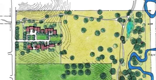
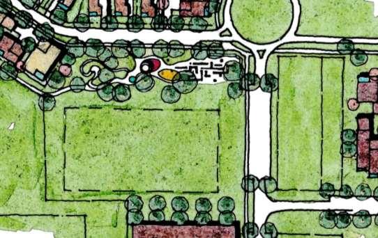
11 GATHERING FACTS POTENTIAL NEIGHBORHOODS

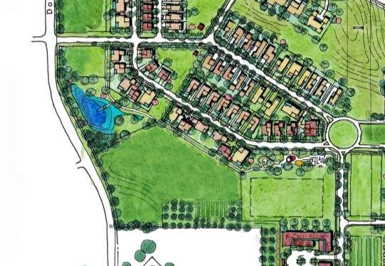
12 SITE ANALYSIS Benchmarks 12

13 SITE ANALYSIS Benchmarks 13


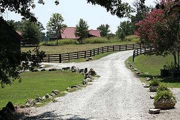
14 SITE ANALYSIS Benchmarks 66 du on 250 acres Jackson Meadow with contemporary farmhouse aesthetic combined with natural landscapes. Large percentage of development as conservancy easements. Simple guidelines include maximum 24 ft. wide homes, 12:12 metal roofs, all white wood cladding, detached garages One mower width edge provided between pavements and 14 native grasslands as an intentional transition


15 SITE ANALYSIS Benchmarks 1,138 du on 95 acres 15


16 SITE ANALYSIS Benchmarks 16

17 SITE ANALYSIS Benchmarks 17


18 SITE ANALYSIS Benchmarks Prairie Crossing outside Chicago with cluster development that preserves wetlands, showcases sustainable practices and has an agricultural community amenity Large homes with front porches and alley loaded garages 18 Loop roads with internal open space and front loaded garages
19 Words for Success: Sustainable Social equity Connectivity External Internal Healthy Destination Inclusive Diversity Kid friendly/attractive to all ages Habitat corridors/loops Safe Eyes on the public realm Diversity Accessibility Capture market Unique Know the market Anticipate the market Heritage/Ethos Sense of place Interactive Sense of community Non-conformity Push-Pull influence of context Innovative housing products Catalyst/stimulus Outreach/Education Inclusive process Residents Developers Incremental development Mix/Range of Density Land uses Product types % of Non-development/Open Space/Agriculture Showcase/model for alternative development Fiscal impact (short-term and long term, social costs ) Agri-community Conservation community Market driven community


20 Benchmarks: 20
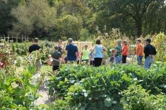
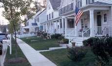
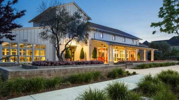
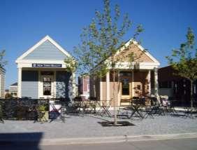
21 Agriculture as tourism/entertainment destination Agricultural heritage as theme/brand Like demonstration gardens and adaptive reuse of barn for retail, community space, education 21


22 Agri-community as an incubator for emerging agricultural businesses, commercial food processing Leasing terms for agri-business needs to be at least three years due to length of time to establish sustainable practices 22


23 Opportunities to integrate senior housing with agri-community amenities such as gardens Raised gardens help maintain a more kept appearance 23
24 Provide connecting trails for walking and biking within the development and as extensions of existing and planned trail systems. Provide trail alignments that respond to floodplain/floodway conditions while also providing shaded environments that interact with the stream s riparian environment. Consider maintenance and safety issues. 24


25 Riparian park with range of activities that interact with the riparian environment including play, exploration, gathering, education, relaxation, fitness, special events 25


26 Range of natural landscapes and uses including woodland edge, native grasses, urban plaza and walking trail Dows Farm provides opportunities to showcase current best practices in environmental restoration, trail design, stormwater management 26


27 affordable, low maintenance, sense of community, snow birds/elderly High quality community space 27

28 Need to explore tiny homes, granny flats, bungalow courts, live/work Make sure it can be implemented within current development laws, review/approval process County allows up to 800 SF secondary residential structures. Min 22 x 22 structures. Consider zero entry housing options for accessibility. Live/work product may be desirable. Requires PUD. Can Live/work provide affordable opportunities for ag. related businesses.? 28


29 Large front porches, inset garage does not require alley, two strip driveway is attractive Other 6ft. porches too small Side loaded garages enhance quality of street experience Duplex and four-plex provide missing middle housing opportunities

30 Townhomes with simple, rural character are attractive Garages provide quiet, shared walls for townhomes and help create a single family home appearance 30


31 Front porches facing a shared open space with rear loaded alleys 31


32 Additional benchmarks include: Farmer s Table in Iowa City Stonebarn Center in upstate New York Restaurant that also trains young farmers National Conservation Training Center in West Virginia Indian Creek Nature Center Amazing space, welcoming feeling, kid friendly Verge Temme Tiny houses in Door County Big Grove in Iowa City Grange, Iowa Lowell Park community center space in Marion In general the benchmarking session emphasized the desire for a unique development that responds to an underserved and relevant market with significant open space systems, both agricultural as well as conservation based, with the development character/quality influenced by the site s agricultural heritage. Range of farm inspired residential architecture Orchard, native plantings and garden integrated into residential yard 32
33 Overall Development/Planning Strategies Framework plans context and focus: Framework plans are 100 year decisions Buildings are 30 to 50 year decisions Programming is a 5 to 10 year decision Land development requires: Control of the land Ability to bring a tenant/buyer Access to money Provide diverse products (depth of market, flexibility to respond to changing market ) while maintaining economies of scale Create and enhance demand with unique product (theme, character, quality) and branding ( Dows Farm name?) while controlling supply (phasing) Ideal absorption rate would be 3 to 5 years. Increase value (net positive effect) while also increasing absorption rate. Ability to finance and maintain proper cash flow impacted by minimizing up front costs and fixed costs. Need strategic, incremental development including the possibility of multiple developers Streets as the public domain = linear public open space system Organize concentric waves of activity/density to increase walkability 33

34 Working Farm Commercial Apartments Multi-family Single-family TOTAL $36 million 100 acres 45,000 gsf 96 DU 32 DU 56 DU 184 DU Conservation Commercial Apartments Multi-family Single-family TOTAL $44 million 80 acres 32,000 gsf 84 DU 22 DU 54 DU 160 DU Commercial Apartments Multi-family Single-family TOTAL $50 million 38,000 gsf 36 DU 44 DU 92 DU 160 DU

35 Working Farm 100 acres Commercial 45,000 gsf Apartments Multi-family Single-family TOTAL $36 million 96 DU 32 DU 56 DU 184 DU Working Farm Conservation 43 acres 88 acres Development 48 acres Conservation 80 acres TOTAL 179 acres Commercial 32,000 gsf Apartments Multi-family Single-family TOTAL 84 DU 22 DU 54 DU 160 DU Commercial 40,700 gsf $44 million Apartments Multi-family Single-family TOTAL 101 du 94 du 186 du 381 du Commercial Apartments Multi-family Single-family TOTAL $50 million 38,000 gsf 36 DU 44 DU 92 DU 160 DU $93 to $119 million
36 The Cloister Prairie/Oak Savannah Native grassland pasture Dows Farm Camp Dows Farm Estate House 50 x75 lots 35 x75 lots 50 x110 lots 35 x75 lots Hippodrome 90 x120 lots Nature Trail Hub 90 x120 lots 65 x110 lots 65 x110 lots 50 x110 lots Four-plex Estate House Center Hall Apts. Live/Work Townhomes Cottages Tuck Under Town The Market The Barn and Market Yard Craft Brewery Farm to table restaurant Specialty retail/pop ups Day Care/services

37 VISION FRAMEWORK

38 VISION FRAMEWORK
39 VISION FRAMEWORK GREEN FINGERS

40 VISION FRAMEWORK WALKWAYS AND PATHWAYS
41 VISION FRAMEWORK STREETS AND LANES

42 VISION FRAMEWORK
43 VISION FRAMEWORK
44 VISION FRAMEWORK

45 VISION FRAMEWORK

46 VISION FRAMEWORK
47 VISION FRAMEWORK

48 VISION FRAMEWORK BRANDING
49


50


51
52


53


54


55


56

57


58

59

60
61


62
63


64


65


66


67 Public Domain Sections Parkway

68 Public Domain Sections Main Street


69 Public Domain Sections Neighborhood

70 Public Domain Sections Mount Vernon Road
71 Words for Success: Sustainable Social equity Connectivity External Internal Healthy Destination Inclusive Diversity Kid friendly/attractive to all ages Habitat corridors/loops Safe Eyes on the public realm Diversity Accessibility Capture market Unique Know the market Anticipate the market Heritage/Ethos Sense of place Interactive Sense of community Non-conformity Push-Pull influence of context Innovative housing products Catalyst/stimulus Outreach/Education Inclusive process Residents Developers Incremental development Mix/Range of Density Land uses Product types % of Nondevelopment/Open Space/Agriculture Showcase/model for alternative development Fiscal impact (short-term and long term, social costs ) Agri-community Conservation community Market driven community
72
73 Working Farm Conservation Development TOTAL 43 acres 88 acres 48 acres 179 acres Commercial Apartments Multi-family Single-family TOTAL 40,700 gsf 101 du 94 du 186 du 381 du $93 to $119 million 73
74 74
Standards (R-3) Figure B-11: R-3 Residential Standards Exhibit
 Figure B-11: R-3 Residential Standards Exhibit") Avila Ranch Avila Ranch Specific Plan Development Standards High Medium Density - High Residential Density Residential Lot and Building Lot and Standards Building (R-3) Standards (R-3) EXAMPLES These sketches
Avila Ranch Avila Ranch Specific Plan Development Standards High Medium Density - High Residential Density Residential Lot and Building Lot and Standards Building (R-3) Standards (R-3) EXAMPLES These sketches
Complete Neighbourhood Guidelines Review Tool
 Complete Neighbourhood Guidelines Review Tool Prepared By: City of Regina Planning Department October 2014 Page 1 of 14 Community Development Review Checklist for Secondary Plans and Concept Plans The
Gold Line Bus Rapid Transit Transit Oriented Development (BRTOD) Helmo Station Area Plan
 Helmo Station Area Plan") Appendix F Gold Line Bus Rapid Transit Transit Oriented Development (BRTOD) Helmo Station Area Plan Introduction and Purpose of the Plan The Gold Line Bus Rapid Transit facility is an eleven-mile dedicated
Appendix F Gold Line Bus Rapid Transit Transit Oriented Development (BRTOD) Helmo Station Area Plan Introduction and Purpose of the Plan The Gold Line Bus Rapid Transit facility is an eleven-mile dedicated
Sahuarita District & Phase 1 Master Plan. Town Council December 11, 2017
 Sahuarita District & Phase 1 Master Plan Town Council December 11, 2017 Visioning Study Visioning Process Advisory Group Meetings Community Questionnaire Town Center Case Studies Community Analysis The
Importance of townhouse design
 Importance of townhouse design Townhouses in the past Townhouses in the past Montco2040 Goals Townhouse Trends in Montco Attached and multifamily housing have become the dominant form of built housing,
MALL REVITALIZATION CASE STUDIES
 MALL REVITALIZATION CASE STUDIES DECEMBER 9, 2012 MALL REVITALIZATION OVERVIEW Introduction Sample Case Studies prepared for Lacey Woodland District Steering Committee as it considers strategies to revitalize
SECTION TWO: Urban Design Concepts
 SECTION TWO: Urban Design Concepts The Gardnerville Plan for Prosperity shapes economic opportunities presented by regional growth. The Urban Design Concepts provide policies and concepts for land use,
3.1 community vision. 3.3 required plan elements
 Chapter 3 Community Form 3.1 community vision 3.2 Parks & landscaping concepts 3.3 required plan elements D R A F T 20 Community Form Chapter 3 3.0 Community form 3.1 community vision The Specific Plan
OPEN HOUSE. Future. Neighborhood. Thursday April 27, :30 8:30 PM Refreshments provided Discovery Center, 4444 Hadley Avenue North
 OPEN HOUSE Thursday April 27, 2017 6:30 8:30 PM Refreshments provided Discovery Center, 4444 Hadley Avenue North The City Council has ini ated a planning process to guide future development on 206 acres
01 Welcome! About Ontario Shores
 01 Welcome! Thank you for participating in the Master Planning Open House. Ontario Shores Centre for Mental Health Sciences is in the process of preparing a Master Program and Master Plan for submission
MAYFIELD WEST SECONDARY PLAN PHASE 2
 MAYFIELD WEST SECONDARY PLAN PHASE 2 Public Open House #3 February 25, 2010 Draft Preferred Land Use Scenario TOWN OF CALEDON PLANNING & DEVELOPMENT DEPARTMENT Open House Agenda TOWN OF CALEDON 1. Welcome
Zoning Code Issues Prioritization
 City of Streetsboro The City of Streetsboro has begun the process of updating its Zoning Code. The new Zoning Code will be based on the recently adopted Comprehensive Plan, which establishes the overall
BISCUIT RUN PARK MASTER PLAN
 BOARD OF SUPERVISORS November 14, 2018 BISCUIT RUN PARK MASTER PLAN COUNTY OF ALBEMARLE ANHOLD ASSOCIATES Contents Project Introduction Property Background County Park Planning Process Existing Site &
Today s Topics. 1. Master Plan Conformance discussion. 2. Planned Unit Development (PUD) Guide Review discussion
 Guide Review discussion") Today s Topics 1. Master Plan Conformance discussion 2. Planned Unit Development (PUD) Guide Review discussion 3. Market Study & Fiscal Impacts discussion 2 2013 Mid Valley Area Community Plan Project
Today s Topics 1. Master Plan Conformance discussion 2. Planned Unit Development (PUD) Guide Review discussion 3. Market Study & Fiscal Impacts discussion 2 2013 Mid Valley Area Community Plan Project
General Location Annex, Rezone & Preliminary Plat Lansdowne Addition, Unit Three
 NEWFOUNDLAND I-5 Agricultural District Subject Site SUNDANCE ANDERSON Single Family Residential CHRISTY PUD Agricultural District Highway Business General Location Annex, Rezone & Preliminary Plat Lansdowne
ELK GROVE GENERAL PLAN VISION
 2-1 CHAPTER 2: 2-2 CREATING OUR The Community Vision for Elk Grove, expressed through a Vision Statement and a series of Supporting Principles, is a declaration of the kind of community that Elk Grove
Description of Preferred Alternative
 Chapter 2 Description of Preferred Alternative 2.1 Introduction This chapter of the programmatic Sammamish Town Center Sub-area Plan Final EIS provides a more detailed description of the Preferred Alternative
URBAN DESIGN BRIEF URBAN DESIGN BRIEF 721 FRANKLIN BLVD, CAMBRIDGE August 2018
 URBAN DESIGN BRIEF URBAN DESIGN BRIEF 721 FRANKLIN BLVD, CAMBRIDGE August 2018 DESIGN BRIEF CONTENTS PART A 1.0 INTRODUCTION 2.0 DESCRIPTION & ANALYSIS OF SITE CONTEXT 3.0 DESIGN CONSTRAINTS AND OPPORTUNITIES
Envision Front Royal Workshop 1 of 2
 Envision Front Royal Workshop 1 of 2 September 12, 2013 Summary The Envision Front Royal project held the first of two public workshops on September 12, 2013. The purpose of the workshop was to evaluate
BROOKHILL NEIGHBORHOOD MODEL ZONING MAP AMENDMENT PREFACE TO APPLICATION
 BROOKHILL NEIGHBORHOOD MODEL ZONING MAP AMENDMENT PREFACE TO APPLICATION June 15, 2015 Revised: August 1, 2016 I. VISION Brookhill is a proposed community based upon the principles of Albemarle County
Calumet Town of New Market, Frederick County Maryland
 Community Design Guidelines Bowman Consulting Group, Ltd. - October 2015 Community Founders: Survey, Engineering and Environmental Miller and Smith Bowman Consultingn Group, Ltd. 8401 Greensboro Drive,
PROPOSED REDEVELOPMENT OF THE GLEN ABBEY GOLF CLUB. STREETSCAPE DESIGN STUDY (excerpt from the Urban Design Brief) TOWN OF OAKVILLE.
 TOWN OF OAKVILLE.") PROPOSED REDEVELOPMENT OF THE GLEN ABBEY GOLF CLUB STREETSCAPE DESIGN STUDY (excerpt from the Urban Design Brief) TOWN OF OAKVILLE OCTOBER, 2016 for 2.4.2 STREETS Streets are the single largest component
PROPOSED REDEVELOPMENT OF THE GLEN ABBEY GOLF CLUB STREETSCAPE DESIGN STUDY (excerpt from the Urban Design Brief) TOWN OF OAKVILLE OCTOBER, 2016 for 2.4.2 STREETS Streets are the single largest component
Seneca Meadows. Block 4 Locate office, technology, and medical development adjacent to I Screen views of garage structures from I-270.
 Seneca Meadows Seneca Meadows has an industrial park in its southern end and a mixed-use employment area planned for the north end. The district benefits from extensive I-270 visibility, stream valley
RE-Imagining the Downtown Colorado Springs Master Plan
 RE-Imagining the Downtown Colorado Springs Master Plan 2016 APA Colorado State Conference October 25, 2016 Overview 8:00 Welcome, Introductions, and Overview 8:15 Downtown s Planning History 8:30 A Market
Westbound: A One-day Exploration of Growth
 Westbound: A One-day Exploration of Growth Frog Pond Area 2018 UGB Expansion Proposal June 13, 2018 Growing Out: UGB Asks Four cities submitted proposals to expand greater Portland s urban footprint by
Planning Board Briefing
 Planning Board Briefing Why Now? The Sector Plan Implementation Chapter States: Before Stage 1 begins, the following must occur: Approval of the Sectional Map Amendment. Approval of the Greater Lyttonsville
Neighborhood Districts
 NEIGHBORHOOD DISTRICTS SEVEN MAIN DISTRICTS Neighborhood Districts While the Development Plan provides a broad-scale overview of the neighborhood, this section focuses on uses and relationships at the
Official Plan Review
 Official Plan Review Summary Report - The Built Environment August 2014 Part 1: Introduction Planning for a healthy, prosperous and sustainable community is an important goal for our municipality. From
Equitable Growth Through TOD Planning
 Equitable Growth Through TOD Planning Community Meeting # 2 November 2017 Goals Objectives Extend investment from downtown Connect neighborhoods physically and economically Enhance places based on local
DRAFT ROOSEVELT ROAD. District Recommendations. Figure 5.23 The Roosevelt Road Corridor
 CHAPTER 5 Figure 5.23 The Road Corridor Road will develop as a mixed-use corridor, emphasizing regional retail, west of the river and mixed-use development east of the river. KEY RECOMMENDATIONS 1. High
HE VISION. Building a Better Connected Place
 HE VISION Building a Better Connected Place WALK INTO THE FUTURE. Life in Cranberry, 2030 Here s what our residents told us they wanted to see in their community by 2030: The Cranberry of 2030 is a place
Welcome! to Keller Town Hall
 Welcome! to Keller Town Hall Keller Town Center Planning a New Downtown What is Keller Town Center? A new, growing downtown district planned as an urban village A combination of retail and office spaces,
Refocus Kodak: Themes and Ideas to Date As of May
 Refocus Kodak: Themes and Ideas to Date As of May 21 2014 The Refocus Kodak Campaign has been hearing from the community since early 2014. Below are some of the themes that we have been hearing and some
CORTEX K. OFFICE SPACES FOR THE MODERN WORKSTYLE DEVELOPED BY KOMAN & AVAILABLE Q4 2019
 CORTEX K. OFFICE SPACES FOR THE MODERN WORKSTYLE DEVELOPED BY KOMAN & AVAILABLE Q4 2019 THE KOMAN GROUP IS DEVELOPING A SIGNATURE MIXED-USE DEVELOPMENT WELCOMING YOUR CUSTOMERS TO CORTEX. FUTURE PHASE
Westwind Developments Ltd. PIONEER LANDS AREA STRUCTURE PLAN - PROPOSED AMENDMENT
 FEBRUARY 2013 TABLE OF CONTENTS 1.0 BACKGROUND... 1 1.1 Amendment... 1 2.0 LOCATION & CONTEXT... 2 2.1 Land Ownership... 2 3.0 POLICY CONTEXT... 3 3.1 Municipal Development Plan... 3 3.2 Capital Region
B L A C K D I A M O N D D E S I G N G U I D E L I N E S for Multi-family Development
 B L A C K D I A M O N D D E S I G N G U I D E L I N E S for Multi-family Development Adopted June 18, 2009 This section of the Design and focuses on site planning and design guidance for new multi-family
Mariposa Lakes. Planned Community. Project Overview. Stockton, CA
 Planned Community Stockton, CA Project Overview March 2007 Summary of Proposed Community is a master-planned community proposed for development on approximately 3,810 acres in southeast Stockton. In 2004,
SQUAMISH 2010 AND BEYOND COMMUNITY VISION
 Our plan has been imagined and created to be both pragmatic and visionary. At the core of the strategy is a consideration of the highway s role and its impact on the community. First and foremost in creating
Lehigh Acres Land Development Regulations Community Planning Project
 Lehigh Acres Land Development Regulations Planning Effort Summary In July, 2010 Commissioner Frank Mann invited the Lehigh Acres community to start discussing how to achieve their recently adopted community
2.0 THE PLATINUM TRIANGLE VISION
 2.0 THE PLATINUM TRIANGLE VISION The envisions an exciting future for the area surrounding Angel Stadium of Anaheim, the Honda Center and The Grove of Anaheim. 2.1 Planning Principles In order to further
PLAN ELEMENTS WORKSHOP. April 5, 2016
 PLAN ELEMENTS WORKSHOP April 5, 2016 needs more housing. But there is no one-size fits-all solution. Every neighborhood has its own character. In some places, density is not only appropriate it is badly
The Five Components of the McLoughlin Area Plan
 The Five Components of the McLoughlin Area Plan This documents contains the complete language of the five components of the McLoughlin Area Plan: The Vision Statement The Values The Guiding Principles
INTRODUCING THE BALTIMORE CITY GREEN NETWORK VISION PLAN
 INTRODUCING THE BALTIMORE CITY GREEN NETWORK VISION PLAN GOALS OF THE GREEN NETWORK PLAN Protect and enhance the unique ecological resources of our city Support economic growth and sustainable redevelopment
Glenborough at Easton Land Use Master Plan
 Vision Statement Sunrise Blvd. Hazel Ave. Prairie City Rd. Gencorp Property Lincoln Regional Airport 1.0 VISION STATEMENT The identifies City of the principles, goals, policies, and standards Lincoln that
E. Natural areas include habitats such as wetlands, tidal marshes, waterways, natural drainage-ways, woodlands and grassland meadows.
 Adopted November 1999 I. Purpose A. The purpose of these guidelines is to assist in the design and layout of open space, as provided on developed lots within the District. The intent of these guidelines
Silver Line CPAM UPDATE. Transportation and Land Use Committee October 14, 2016
 Silver Line CPAM UPDATE Transportation and Land Use Committee October 14, 2016 Purpose Recap Project History and Map Changes Provide Overview of CPAM Components Discuss Transportation Impacts Discuss Fiscal
BROOKLYN PARK / 85TH AVE LRT STATION CDI DEVELOPMENT GUIDELINES DRAFT
 August 2018 Page intentionally left blank The Brooklyn Park Library adjacent to the 85th Ave LRT Station Area. OVERVIEW The Blue Line LRT Extension / Bottineau corridor offers a unique opportunity to leverage
GOLDEN MILE SECONDARY PLAN. Community Consultation Meeting #3 June 26, 2018
 GOLDEN MILE SECONDARY PLAN Community Consultation Meeting #3 June 26, 2018 Meeting Overview 1. Introduction 2. Principles + Vision 3. Street + Block Alternatives 4. Parks + Open Space Alternatives 5. Land
SUMMARY MEETING. The following is a compilation of voting results from all five visioning sessions.
 SUMMARY MEETING The following is a compilation of voting results from all five visioning sessions. WHO ARE YOU? The next 10 graphs show compiled demographic information about the participants at all 5
Town Center (part of the Comprehensive Plan)
") Town Center (part of the Comprehensive Plan) Mercer Island Town Center Looking North (2014) In 1994, a year-long process culminated in a set of design guidelines and code requirements for the Town Center
Town Center (part of the Comprehensive Plan) Mercer Island Town Center Looking North (2014) In 1994, a year-long process culminated in a set of design guidelines and code requirements for the Town Center
Isabel Neighborhood Plan: Alternatives
 Isabel Neighborhood Plan: Alternatives Presented by: Lori Parks, Associate Planner February 2, 2015 Agenda 1. Background on BART to Livermore 2. Isabel Neighborhood Plan 3. Alternative Scenarios 4. General
Throughout. square. (Crystal City Vision Plan 2050)
") 1: Terms related to the PSMP document 1 public space (see also public realm, civic space) An open space designated on the regulating plan, accessible to all, including Plazas, Mini Parks, and Neighborhoods
1: Terms related to the PSMP document 1 public space (see also public realm, civic space) An open space designated on the regulating plan, accessible to all, including Plazas, Mini Parks, and Neighborhoods
GUIDING PRINCIPLES IN THIS CHAPTER
 GUIDING PRINCIPLES The guiding principles and design concepts in this chapter work together with the Chapel Hill 2020 Comprehensive Plan to support new public places that can be enjoyed by all while also
Urban Park Guidelines
 Park Planning & Stewardship Division Park & Trail Planning Section Urban Park Guidelines Objectives, Outreach Strategy Recommendations and Plan Schedule PARK PLANNING & STEWARDSHIP Brooke Farquhar, Rachel
The principal elements of the NTC Strategic Vision plan are as follows.
 The proposed project would improve the NTC site plan, circulation, visitor amenities, and landscaping, and would include construction of two new stadiums to replace the existing Louis Armstrong Stadium
Potential Green Infrastructure Strategies May 6, 2015 Workshop
 Potential Green Infrastructure Strategies May 6, 2015 Workshop Background The City of Cortland is developing the Tioughnioga Urban Headwaters Green Infrastructure Action Plan with funding from the National
Vision Statement for the Town of Flower Mound Master Plan The Town of Flower Mound Master Plan furthers the established community based vision to:
 Vision Statement for the The furthers the established community based vision to: Preserve the country atmosphere and natural environment that makes Flower Mound a unique and desirable community; Mitigate
DRAFT. 10% Common Open Space
 % OF CHARLOTTE IS CATEGORIZED AS A. LAND USES : Placeholder map displaying location of Place Type GOALS: Accommodate XX% of future growth. Provide a concentration of primarily commercial and civic activity
Lowe Park Master Plan Update Marion, IA August 25 th, 2011
 Lowe Park Master Plan Update Marion, IA August 25 th, 2011 Lowe Park Master Plan Update Concept Plan - June 1 st, 2011 Agenda 1 - INTRODUCTION Vision Statement Aerial of Existing Condition 2 MASTER PLAN
for Master Planned Development Framework Design Standards & Guidelines
 B L A C K D I A M O N D DE S I G N G U I D E L I N E S for Master Planned Development Framework Design Standards & Adopted June 18, 2009 Introduction and Purpose The Master Planned Development (MPD) Framework
Eastcreek Farm. Planned Development Standards September, 2014
 Eastcreek Farm Planned Development Standards September, 2014 ekfarm Contents 01. General Standards 02. Residential Development Standards 03. Architectural Design Standards 04. Landscape Design Standards
4 C OMMUNITY D ISTRICTS
 4 C OMMUNITY D ISTRICTS N ew development in the Area will include many different types of land uses, including a destination retail area that attracts people from all over the region; recreation opportunities
2.0 AREA PLANS. Lakeside Business District. Lakeside Business District Land Use Categories:
 Lakeside Business District Lakeside Business District Land Use Categories: Campus Commercial Campus Commercial means a mixture of uses which includes corporate offices, office parks, hotels, commercial,
Ivywild On The Creek PRELIMINARY CREEK DISTRICT MASTER PLAN
 Ivywild On The Creek PRELIMINARY CREEK DISTRICT MASTER PLAN Introduction: Rejuvenating an extraordinary Creekside neighborhood THE CREEKSIDE DISTRICT The Ivywild On The Creek Neighborhood District Master
A Vision for Walnut Creek
 A Vision for Walnut Creek Photo: City of Clive Walnut Creek Booklet 8 of 8 Greater Des Moines Water Trails and Greenways 1 Table of Contents Booklet 1: Water Trails Strategies and Policies Booklet 2: Beaver
ARTICLE 2 FORM BASED DISTRICT STANDARDS
 ARTICLE 2 FORM BASED DISTRICT STANDARDS 2.1 INTENT 2.1.1 Intent It is the intent of these standards to: a. Provide the City of Rowlett with pedestrian-oriented/bicycle-friendly districts and neighborhoods
The Vision. Photo provided by The Minervini Group. 46 Vision, Objectives & Strategies
 Vision, Objectives & Strategies The is the public framework and guide for future development of the Grand Traverse Commons. The establishes public polices for infrastructure, the preservation of natural
EXISTING TOWNHOUSE. What s working & What s not?
 What s working & What s not? Distance from the sidewalk/street to the building Landscape vs. Hardscape in front of the building Porches, stoops, steps, and entries Residential vs. contemporary character
Concrete Flat Tile Roofs Large Exposed Overhangs Oversized Bracing Predominately Gable Roofs With Non-Plaster Gable End Treatments.
 Avila Ranch Concrete Flat Tile Roofs Large Exposed Overhangs Oversized Bracing Predominately Gable Roofs With Non-Plaster Gable End Treatments Simple Trim Figure B-22: Craftsman Architectural Style Low
Discuss contract with The Summerill Group, LLC for consulting and negotiating new federal per diem rate for Linn County Correctional Center
 LINN COUNTY BOARD OF SUPERVISORS MEETING AGENDA Tuesday, January 22, 2019 10 a.m. Formal Board Room Jean Oxley Public Service Center 935 2ND ST. SW, Cedar Rapids, IA Call to Order Public Comment: Five
Silverdale Regional Center
 Silverdale Regional Center Vision for Silverdale Regional Center The Silverdale Regional Center Plan (Plan) will guide the evolution of the Silverdale Regional Center from a collection of strip malls and
MONTGOMERY COUNTY METRO STATION AREA DESIGN CHARRETTE
 MONTGOMERY COUNTY METRO STATION AREA DESIGN CHARRETTE Shady Grove Metro Station Area Charrette Closing Presentation October 25-28, 2000 MONTGOMERY COUNTY, MD M-NCPPC Design Collective, Inc. Architects
DOWNTOWN GEORGETOWN PLANNING STUDY
 DOWNTOWN GEORGETOWN PLANNING STUDY Community Workshop #3 Thursday, May 4, 08 The Planning Partnership OVERVIEW OF STUDY, PROCESS & MILESTONES We are here PURPOSE OF THE STUDY To develop a clear vision
Joint Study Session of the Sutter County. March 2, 2009
 Joint Study Session of the Sutter County Board of Supervisors and Planning Commission March 2, 2009 CURRENT APPLICATION General Plan Amendment Specific Plan Specific Plan Appendices Utility Plans Transit/AQ
How can we improve mobility and access?
 How can we improve mobility and access? North King s Town is located fairly centrally within the city, but there are still multiple opportunities to improve mobility within the study area, including connections
APPENDIX A 6 CONCEPTUAL PRELIMINARY PLAN GUIDE AND CHECKLIST FOR MAJOR SUBDIVISIONS CARRBORO DEVELOPMENT GUIDE APPENDIX A
 6 CONCEPTUAL PRELIMINARY PLAN GUIDE AND CHECKLIST FOR MAJOR SUBDIVISIONS Conceptual Preliminary Guide/Checklist for Major Subdivisions Page 1 FORM: REVIEW DATE: CONCEPTUAL PLAN REVIEW 2000 REVIEWED BY:
Ville de. Côte Gelée
 Ville de Côte Gelée ARCHITECTURE & DESIGN GUIDELINES - DRAFT JUNE 28, 2006 Youngsville Hwy (LA Hwy 89) Youngsville Hwy (LA Hwy 89) Project Summary & Site Context Evangelline Hwy (US 90) La Neuville Road
Walnut Creek BART Station
 Walnut Creek BART Station Mixed Use Transit Oriented Project Design Review Commission Study Session May 17, 2006 Applicant: Walnut Creek Transit Lifestyles Associates Joint Venture: Transit Village Associates
Chapter 5: Natural Resources and Environment
 NATURAL RESOURCES AND ENVIRONMENT 5-1 5 Chapter 5: Natural Resources and Environment BACKGROUND AND INTENT Urban expansion represents the greatest risk for the future degradation of existing natural areas,
The Ritz-Carlton, Paradise Valley
 The Ritz-Carlton, Paradise Valley 7000 E. Lincoln Drive Keys to Success Community Conversation II June 4, 2015 RITZ-CARLTON PARADISE VALLEY Town Council Study Session June 4, 2015 General Plan 2012 Land
SCORE CARD RESULTS. Power Tool Results. Vision Georgetown Draft Land Use Concept
 SCORE CARD RESULTS Power Tool Results Vision Georgetown Draft Land Use Concept Results of Public Consultation Open House Sept. 20, 2017 Positives - What do you like about the Plan? Walkability and Bike
MOUNT PLEASANT COMMUNITY PLAN
 MOUNT PLEASANT COMMUNITY PLAN What is a Community Plan? A community plan describes what the community should be like in the future: it identifies what is valuable and should be retained, as well as Key
Brampton. Secondary Plan. Review. Bram West. A New Direction in Planning & Public Consultation
 Brampton Bram West Secondary Plan Review A New Direction in Planning & Public Consultation Introduction The Bram West Secondary Plan Review offers an important opportunity for the community to define a
DOMINION BOULEVARD CORRIDOR STUDY AND ECONOMIC DEVELOPMENT STRATEGIC PLAN A MODEL FOR CHESAPEAKE S FUTURE
 DOMINION BOULEVARD CORRIDOR STUDY AND ECONOMIC DEVELOPMENT STRATEGIC PLAN A MODEL FOR CHESAPEAKE S FUTURE Overview I. Draft Plan Process II. Draft Plan Overview a. Market Analysis b. Master Land Use Plan
CENTRAL ESTUARY PLAN AVISION FOR OAKLAND S WATERFRONT
 Central Estuary Plan A VISION FOR OAKLAND S WATERFRONT Specific Plan and Environmental Assessment Presentation to the Parks and Recreation Advisory Commission December 9, 2009 This Afternoon s Presentation
What Pioneer Grove Will Look Like?
 The City of Deerfield Beach has embarked on a journey to create a new town center within the old heart of Deerfield Beach. The new town center is known as Pioneer Grove. Pioneer Grove will be Everybody
URBAN DESIGN + PLANNING BRIDGING COMMUNITIES
 URBAN DESIGN + PLANNING BRIDGING COMMUNITIES East Pleasanton, Pleasanton, CA CARDUCCI ASSOCIATES PROFILE Founded in 1976, Carducci Associates is a professional landscape architecture and planning firm
Shared Principles and Emerging Plan Directions
 Shared Principles and Emerging Plan Directions Introduction Since the Fairfield Neighbourhood planning process launched in June 2016, we have heard from many residents, businesses, groups and other people
The Village at Loomis. Long-Envisioned A Wonderful Place to Call Home
 at Loomis Long-Envisioned A Wonderful Place to Call Home The Vision Implementing the Town s Plans and Goals Years ago, the Town established the vision for The Village at Loomis in plans and EIRs approved
St. Louis Park Wooddale LRT Station Site development guidelines
 St. Louis Park Wooddale LRT Station Site development guidelines November 2013 OVERVIEW St. Louis Park s convenient location as a neighbor to Minneapolis means you re only minutes away from some of the
ARLINGTON COUNTY, VIRGINIA
 ARLINGTON COUNTY, VIRGINIA County Board Agenda Item Meeting October 15, 2005 DATE: September 28, 2005 SUBJECT: Request to Advertise the adoption of the 2005 Clarendon Sector Plan C. M. RECOMMENDATION:
2011 ASLA Design Awards. Centennial Park Merit Award Design Concepts CLA, Inc. Design over $500,000 Construction Budget
 2011 ASLA Design Awards Centennial Park Merit Award Design Concepts CLA, Inc. Design over $500,000 Construction Budget 2011 ASLA Colorado Professional Design Awards Project Name: Category: Location: Const.
Municipal Plan*Assessment
 Municipal Plan*Assessment This tool was developed to assist in reviewing municipal master plans and in determining if these plans are consistent with smart growth principles, neighboring municipal plans,
MEETING PURPOSE AND OVERVIEW
 MEETING PURPOSE AND OVERVIEW On February 23, 2012, the City of Elk Grove hosted the first of two community workshops related to the Southeast Policy Area. The workshop was held from 6:00 8:30 p.m. in the
Prosperity Hucks Area Plan. Transportation and Planning Committee May 11, 2015
 Prosperity Hucks Area Plan Transportation and Planning Committee May 11, 2015 Presentation Outline 1. Background and Location 2. Community Dialog Process 3. Activity Center Recommendations 4. Wedge Recommendations
ITA and Vicinity Master Plan Update
 1 ITA and Vicinity Master Plan Update PHASE 3 SEPTEMBER 27, 2017 Three Phase Process 2 Phase 1 - Understanding October 13th Public Meeting Phase 2A - Exploring Ideas November 17th Public Meeting Phase
Welcome to the Neighborhood! COPPERLEAF NEIGHBORHOOD GUIDE
 Welcome to the Neighborhood! COPPERLEAF NEIGHBORHOOD GUIDE 2017 At Copperleaf, feeling at home just comes naturally. Not surprising when you take a look around at the abundance of resources we offer to
Subarea 4 Indian Creek. Vision The combination of park networks and transportation amenities make Subarea 4 the greenest hub in the Corridor.
 indian creek 180 extends south from 101st Street to I-435. The I-435 and Metcalf intersection is one of the primary intersections in the Kansas City Metro Area. The area includes several residential neighborhoods
CHAPTER 4 FUTURE LAND USE AND URBAN SERVICES DISTRICTS
 CHAPTER 4 FUTURE LAND USE AND URBAN SERVICES DISTRICTS Introduction This chapter discusses how Benzie County should grow and change in the future. A community can grow and change in many different ways.
East Garrison Pattern Book. Urban Design Associates
 East Garrison Pattern Book Urban Design Associates july 2004 Design Guidelines for a New Community Master Developer east garrison partners 1, llc Master Code Consultant urban design associates Pittsburgh,