It Seems Possible to
|
|
|
- Hannah Dennis
- 5 years ago
- Views:
Transcription

1 It Seems Possible to by Elwood L. Shafer, Jr. and James Mietz U.S.D.A. FOREST SERVICE RESEARCH PAPER NE NORTHEASTERN FOREST EXPERIMENT STATION, UPPER DARBY, PA. FOREST SERVICE, U. S. DEPARTMENT OF AGRICULTURE RICHARD D. LANE. DIRECTOR
2 The Authors ELWOOD L. SHAFER, JR., is project leader for the Northeastern Forest Experiment Station's recreation research project at the New York State University College of Forestry at Syracuse University, Syracuse, N. Y. He holds B.S. and M.F. degrees from Pennsylvania State University and a Ph.D. degree from the New York State College of Forestry. He joined the Northeastern Station in JAMES MIETZ, at the time of this study, was a senior forestry student at Utah State University. He is serving with the U.S. Army in South Vietnam.
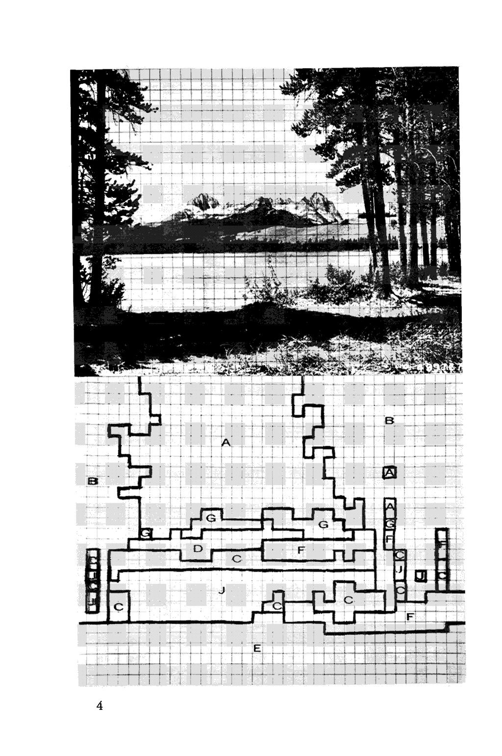
3 TO PARAPHRASE KIPLING: East is West, and West is East-as far as a recent experiment in landscape preference is concerned. Our study indicated that recreationists in Utah and New York prefer the same kind of forest landscapes -when the landscapes are depicted by 8- by 10-inch black-andwhite photographs. A landscape-preference model that was developed and tested on recreationists in New York (Shafer and others 1969) predicted the overall landscape preference pattern of outdoor recreationists near Salt Lake City, Utah. Results of our expeeiment suggest that the model can be used by regional planners throughout the United States to help evaluate and compare quantitatively the aesthetic quality of different landscapes. When it was developed, the model explained 66 percent of the variation in landscape preference scores of 250 Adirondack campers. Also, in independent field tests, the model predicted the overall landscape preferences of 300 other campers throughout New York State (Shafer and others 1969). Thus, we knew the model worked in the Northeast. The next step was to test how well the model predicted preferences of western recreationists; that was the objective of this study. The study was conducted in cooperation with Utah State University. First, it is necessary to briefly describe how the model was developed and how it works. Initially, we defined eight zones within a landscape photograph: Zone A. Sky and clotlds: All sky and cloud areas. Zone B. Immediate trees and shrzlbs: Those parts of a photo where individual leaf and bark characteristics are visible if in full light.
4 Zone C. Intermediate trees and shrubs: Areas on a photo where outlines of individual trees and shrubs can be recognized but not in the fine detail found in zone B. Zone D. Distant trees and shrubs: Areas where shapes of individual trees and shrubs cannot be distinguished. Zone E. Immediate other fea~ures: Areas that contain rocks, grass, snow, or soil and where the texture, blades of grass, or detailed characteristics of the individual rocks and boulders can be distinguished if in full light. Zone F. Intermediate other features: Places where the outlines of large rosks, large crevices, or prominent features of soil, grass, or snow are visible but not in the detail found in zone E. Zone G. Distant other features: Areas where snow, rocks, grass, or soil occur, but no details of these features are visible. Zone J. Water: All water areas, including streams, lakes, waterfalls, and rocks visible within the boundaries of those water areas. For any 8- by 10-inch black-and-white photograph, the landscape preference model used measurements in six of the eight zones to predict a landscape's preference score (Y). where: (X,. x,) (Xp. X,) (X,. X,) (X,. X,) (X,. X,) x,' XB2 X, = perimeter of the immediate tree-and-shrub zone. X, = perimeter of intermediate other-features zone. X, = perimeter of distant tree-and-shrub zone. X, = area of intermediate tree-and-shrub zone. X, = area of water zone. X, = area of distant other-features zone. The lower the Y value, the more preferred the landscape. Values for the independent variables were obtained by placing a %-inch plastic grid over a photograph (fig. 1) and making landscape-zone area or perimeter measurements as follows:
5 The eight landscape zones are outlined on a photograph by using the edges of the squares as boundary lines. All six zones will not necessarily occur on any one photograph. The perimeter measurement for variable X,, X,, or X, is the total number of 1/4-inch edges of each square along the boundary of that particular zone. If a zone occurs at different locations on the photo, add that zone's perimeter measurements for all locations. The area measurement for variables X,, X,, or X, is the total number of %-inch squares within that specific zone. Again, if a given zone occurs at different locations, add that zone's area measurements for all locations. Initially, fourteen 8- by 10-inch photos were selected randomly from the original 100 photos used to develop the model. The 14 photos were sorted randomly into two sets-a and B--with seven photos in each set (figs. 2 and 3). In August 1967, we randomly selected 50 day-users throughout the Big Cottonwood and Mill Creek Canyon recreation areas on the Wasatch National Forest-a half hour's drive from Salt Lake City, Utah. Each of the 50 respondents was asked to rank the seven landscapes in each set. The photo ranked first was the most preferred, and so on until the photos were ranked 1 through 7 per set. We restricted the interviews to people who lived in the Salt Lake City area. All respondents were 12 years of age or older. There were no non-respondents. Thus, each photo received 50 rank values that could range from 1 to 7; the sum of these 50 values was a photo's overall observed preference score (Y'). Theoretically, a Y' value could range from 50 to 350. Observed scores for photos in set A ranged from 128 to 265; in set B, they ranged from 138 to 278. Next, on each photo we measured the six perimeter or area variables required for the landscape preference model and computed the photo's predicted preference score (Y). Predicted
6
7 Figure I.-A %-inch ~lastic grid is laid over a ~hoto (top), and the edges of the squares are used to outline the various landscape zones (bottom). Measurement values for this example are: Landscape Measurement Model variable Zone A. Not required - B. Perimeter XI C. Area x4 D. Perimeter x3 E. Not required - F. Perimeter x2 G. Area x, J. Area x5 Solving for landscape's preference score: Y = (226) (92) ( ) ( ) (44. 98) (92. 30) (77. 30) (77. 98) (226) (98)2 Y = 89 Value

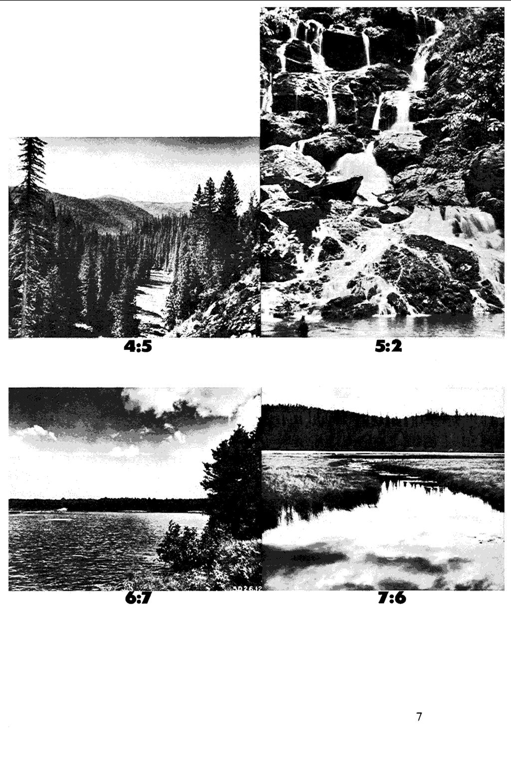
8 Figure 2.-Landscape photos used in set A. The two numbers under each photo are its predicted and observed rankings, respectively. The coefficient of concordance = 0.851, and the F value = 5.71, which is significant at the 95-percent level.
9

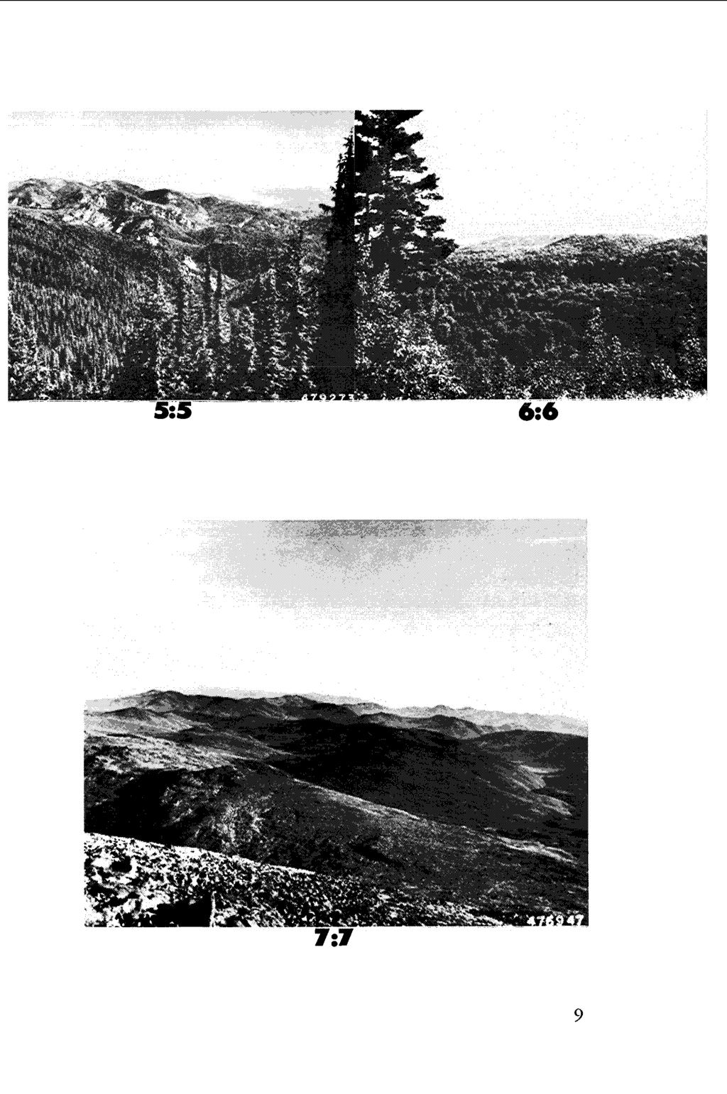
10 Figure 3.-Landscape photos used in set B. The two numbers under each photo are its predicted and observed ranking, respectively. The coefficient of concordance = 0.921, and the F value = 11.66,which is significant at the 95-percent level.
11
12 scores in set A ranged from 71 to 174; set B scores ranged from 99 to 212. Finally, the observed and predicted preference scores were ranked separately from 1 to 7. The coefficient of concordance (Walker and Lev 1953) was used to test how well the observed and predicted ranks agreed. The coefficient was significant for both sets (fig. 2 and 3) ; this means that the predicted and observed ranks showed agreement far beyond what might be produced by sampling variance. To understand why we compared rank values rather than numerical scores, consider the following possibility. Assume that a test with seven pictures contains one average - and six belowaverage-quality landscapes. The average picture will receive a much better score than it would if it were compared with six above-average quality landscapes. Thus, when only seven pictures are used in a test, biased scores could be obtained. To compare observed and predicted scores we would have had to conduct our survey with 100 different photographs as we did when we developed the model. We felt that a comparison between predicted and observed ranks was sufficient to test whether or not the model predicts landscape preferences of western recreationists. The landscape preference model worked fairly well in the West. Although the model predicts preferences for photos of landscapes-not for the landscapes themselves-the procedure seems realistic and practical. Advantages and disadvantages of using photographs in experiments of this kind are discussed elsewhere (Shaf er and Rutherf ord 1969). In set A, the observed and predicted ranks never agreed exactly but usually differed by only one rank value (fig. 2). The largest difference between a predicted and observed rank occurred in set A: a watefall was predicted to be ranked fifth but actually ranked second (photo labeled 5:2 in fig. 2). This same photo shows a smaller area of the landscape than any of the other six
13 in the set. Therefore, future surveys that use the model to evaluate landscapes might stratify photos first into macro and micro environments. However, stratification may not always be possible; it depends on the number and variety of landscapes to be evaluated. All landscapes in set A have some water, but only four landscapes in set B contain water (figs. 2 and 3). Closer agreement between predicted and observed ranks in set B suggests that the model may more accurately predict preferences for landscapes that do not contain water. Perhaps the model could be improved if it included additional variables that describe water environments in more detail. Such details might include the area and perimeter of dark and light shapes within the total water area and the height of a waterfall in relation to other features in the landscape. In addition, it may be helpful in future research to stratify water areas into lakes, streams, waterfalls, and rivers. On the basis of observed preference scores in set A, our respondents preferred vaious types of water environments in this order : Pictnre Obserued rank Waterfall, stream, and lake combined 1 Mutliple waterfalls 2 Single waterfall and stream (rocky shoreline) 3 and 4 Stream (rocky shoreline) 5 Lake 6 Stream (swampy shoreline) 7 In set B, the observed and predicted ranks were the same for four pictures (fig. 3). However, three of the four photos that included water were ranked differently than predicted. Furthermore, one of these three water scenes was a close-up of a waterfall, while all other photos in set B included a much greater area of landscape. By knowing that quantitative features in the photo of a landscape affect its aesthetic appeal, resource managers and planners can begin to have a factual basis, in addition to an intuitive one, for decisions about wildland aesthetics. Results of our study provide several clues that may sharpen
14 the model's predictive capabilities. The main point is that it seems possible to quantify certain aspects of the forest landscape, and furthermore, that our methodology presents a reliable approach. However, additional research is needed to test how well preferences for photos of landscapes compare with preferences for those same landscapes when viewed on the ground. Granted, our procedure for quantifying aesthetics does not provide an economic value for aesthetic quality; this may never be possible. At the most, the model provides a quantitative index of how much one landscape is generally preferred over another, and therefore, may ibe used to assign weighted preference value to different natural landscapes. Future research is needed to determine the relationship, if any, between preference value and the real-estate value of a given landscape. Additional research, using our methodology, is also necessary to predict preference for different elements within an environment-shapes, sizes, and colors of individual trees, for example. Shafer, Elwood L., Jr., John F. Hamil- NATURAL BEAUTY IN TWO ADIRONton, Jr., and Elizabeth Schmidt. DACK FOREST STANDS. J. Forestry NATURA LANDSCAPE PREFER- ENCES: A PREDICTIVE MODEL. J. 67 (6) : Leisure Res. l(1) :1-19. Shafer, Elwood L., Jr., and William Walker, Helen M.9 and Joseph Lev. Rutherford STATISTICAL INFERENCE SELECTION CUTS INCREASED pp. Henry Halt and Co,, N. Y.
15 THE FOREST SERVICE of the U. S. Department of Agriculture is dedicated to the principle of multiple use management of the Nation's forest resources for sustained yields of wood, water, forage, wildlife, and recreation. Through forestry research, cooperation with the States and private forest owners, and management of the National Forests and National Grasslands, it strives - as directed by Congress - to provide increasingly greater service to a growing Nation.
Landscape Conservation Design April, 2014
 Designing Sustainable Landscapes in the Northeast A project of the North Atlantic Landscape Conservation Cooperative & Northeast Climate Science Center Landscape Conservation Design April, 2014 Conceptual
2011 ASLA Design Awards. Coyote Gulch Honor Award and Land Stewardship Designation Valerian LLC. Environmental Restoration and Reclamation
 2011 ASLA Design Awards Honor Award and Land Stewardship Designation Valerian LLC Environmental Restoration and Reclamation Project Name: Category : Project Location: 5 2011 Environmental Restoration and
Smoke Alarm Response Time:
 Smoke Alarm Response Time: Examining the Relationship Between Working Smoke Alarms, Fire Service Response Times and Fire Outcomes Joseph Clare, Charles Jennings, Len Garis November 2018 Executive Summary
Master Planning: Cuba, New York Phase II. Dr. John Anderson President Alfred State College. Alfred New York
 Master Planning: Cuba, New York Phase II Dr. John Anderson President Alfred State College Alfred, New York 14802 607-587-4211 February 1, 2011 June 30, 2012 March 5, 2012 Craig R Clark, PE Dean, School
A Comparative Study on the Utilization Configuration and Characters of Urban Comprehensive Park in China and Korea
 International Conference on Management Science and Innovative Education (MSIE 5) A Comparative Study on the Utilization Configuration and Characters of Urban Comprehensive Park in China and Korea Xiaoyan
HOT IN HERE: OFFICE OCCUPANT THERMAL COMFORT IN LAWRENCE HALL
 GROUP 1 HOT IN HERE: OFFICE OCCUPANT THERMAL COMFORT IN LAWRENCE HALL Daniel Abrahamson Department of Architecture University of Oregon Eugene, Oregon 97403 dva@uoregon.edu Dijon Jones Department of Architecture
Wetland Types. Grade Level: Basic. Duration: 30 minutes. Setting: Classroom
 Wetland Types Adapted from: An original Creek Connections activity created by Cassandra Hamilton. Creek Connections, Box E, Allegheny College, Meadville, PA 16335 http://creekconnections.allegheny.edu
RAIN GARDENS. Task: PART 1 (60 minutes) Student Directions: Steps you will be following: Directions for beginning: Source Information:
 Student Directions: Steps you will be following: Directions for beginning: Source Information:") PART 1 (60 minutes) Student Directions: Your assignment: Steps you will be following: Your neighborhood council is researching the benefits of installing rain gardens in your community. You will read two
PART 1 (60 minutes) Student Directions: Your assignment: Steps you will be following: Your neighborhood council is researching the benefits of installing rain gardens in your community. You will read two
People, Places and Landscapes
 People, Places and Landscapes Landscape Series Volume 14 Series Editors: Henri Décamps Centre National de la Recherche Scientifique Toulouse, France Bärbel Tress TRESS & TRESS GbR Munich, Germany Gunther
OBSERVING THE EXPANSION OF THE BUILT-UP AREAS OF REGIONAL CAPTAIL CITIES IN YANGTZE RIVER DELTA BY SATELLITE IMAGES
 OBSERVING THE EXPANSION OF THE BUILT-UP AREAS OF REGIONAL CAPTAIL CITIES IN YANGTZE RIVER DELTA BY SATELLITE IMAGES Kiyoshi TORII 1), Yoshiaki MORI 1), Zengmin JI 2), Yohei SATO 3), Kuninobu OTSUBO 4)
doyle + o troithigh landscape - architecture
 doyle + o troithigh landscape - architecture REPORT: PROJECT: LANDSCAPE DESIGN REPORT. STUDENT HOUSING DEVELOPMENT AT WESTWOOD HOTEL SITE. DATE: MAY 2018. www.doyle-otroithigh.com Landscape design report,
Unit II Soil Management
 Unit II Soil Management Lesson 2: Using Soil Survey Manuals Soil survey manuals provide useful information for grassland management. Soil scientists evaluate the soil for chemical and physical properties,
Prediction of Soil Infiltration Rate Based on Sand Content of Soil
 Agricultural Engineering Research Journal 3 (): 0-4, 013 ISSN 18-3906 IDOSI Publications, 013 DOI: 10.589/idosi.aerj.013.3..1109 Prediction of Soil Infiltration Rate Based on Sand Content of Soil 1 1 Majid
LANDSCAPE VISUAL QUALITY ASSESSMENT IN WASHTENAW COUNTY, MI
 LANDSCAPE VISUAL QUALITY ASSESSMENT IN WASHTENAW COUNTY, MI Jiawei Huang Advisor: Oliver Kiley School of Natural Resources and Environment University of Michigan, Ann Arbor Visual Quality Visual Quality
Analysis of Landscape Character for Visual Resource Management 1
 Analysis of Landscape Character for Visual Resource Management 1 Paul F. Anderson 2/ Abstract: Description, classification and delineation of visual landscape character are initial steps in developing
Alternative Crop Suitability Methodology
 Alternative Crop Suitability Methodology The Alternative Agriculture in Missouri Hub on Community Commons includes model-based ratings of natural suitability for selected alternative crops. These ratings
Alternative Production Methods for Landscape Trees: Some Preliminary Survey Results from Landscape and Nursery Professionals. 1
 Alternative Production Methods for Landscape Trees: Some Preliminary Survey Results from Landscape and Nursery Professionals. 1 In 2010, researchers at the University of Massachusetts and the University
Q&A with Jerry Adelmann: The green legacy of Daniel Burnham. By Patrick T. Reardon on Tue., 08/24/ :00 am.
 were made, said Jerry Adelmann, executive director of Openlands. THE BURNHAM BLOG Vision & Theme About the Logo Centennial Committee and Staff Sponsors Newsroom News Coverage Press Releases E-News & Social
Balancing Conservation and Development on the Jordan River
 Balancing Conservation and Development on the Jordan River Jordan River Parkway Trail Regional Athletic Complex Conservation & Restoration Balancing Conservation and Development on the Jordan River Jordan
Site Suitability Analysis of Green Infrastructure in Austin, TX
 Site Suitability Analysis of Green Infrastructure in Austin, TX Droughts have plagued Texas as far back as the first written meteorological records. Currently in Fall of 2014 we are in stage 2 water restrictions
The Effect of Spray Sprinkler Spacing on Distribution Uniformity
 The Effect of Spray Sprinkler Spacing on Distribution Uniformity Nina Colasurdo, CLIA M.S. Cal Poly Pomona University, DIG Commercial Sales Representative, ctcolasurdo@csupomona.edu Ramesh Kumar, PhD,
Community Acceptance of Stormwater BMPs
 GREENER STORMWATER SERIES MARCH 4, 2014 Community Acceptance of Stormwater BMPs Kansas City Water Services Water Wastewater Stormwater 2 Water Service s Green Infrastructure 3 Topics Psychology Behind
National Radon Results: 1985 to 1999 Brian Gregory 1 Philip P. Jalbert, U.S. EPA
 Brian Gregory 1 Philip P. Jalbert, U.S. EPA Since the mid-1980s the United States has made significant progress in reducing the risk from exposure to radon. This progress is the result of a long-term effort
Protect Our Ponds: A communitybased social marketing task force to improve water quality
 Protect Our Ponds: A communitybased social marketing task force to improve water quality The challenge of controlling nutrients from stormwater runoff The stormwater system links all of the yards in the
Mark Greenig Recreation and Land Use Planner CH2M Hill
 Mark Greenig Recreation and Land Use Planner CH2M Hill Land Use (Slide L1) Objectives: Document existing land uses in the Study Area along with identifying applicable land use and management plans. Evaluate
UPPER BRODHEAD CREEK PARADISE CREEK GREENWAY PLAN
 UPPER BRODHEAD CREEK PARADISE CREEK GREENWAY PLAN The Upper Brodhead & Paradise Creeks Greenway Cooperating Municipalities Mount Pocono Borough Paradise Township Barrett Township Price Township Funding
Erich BUHMANN, James PALMER, Matthias PIETSCH and Sarita MAHADIK
 Managing the Visual Resource of the Mediterranean Island of Gozo, Malta for Tourists A Studio Approach for International Conversion Students, Bridging Different Levels of English Erich BUHMANN, James PALMER,
The Darby Cobbs Stormwater Initiative: Getting to the New Normal
 The Darby Cobbs Stormwater Initiative: Getting to the New Normal Jamie N. Anderson, Eastern Delaware County Stormwater Collaborative Diana Andrejczak, Pennsylvania Resources Council Nora Schmidt, Darby
MNLA Curriculum Unit B, Lesson 2
 MNLA Curriculum Unit B, Lesson 2 UNIT TITLE: Using Math to Create Functional Landscapes: LESSON 2: Designing Shrub and Flower Beds; 30-40 minutes MINNESOTA ACADEMIC STANDARDS IN SCIENCE: 3.1.3.2.2 -- Recognize
Overview of Southwestern Pennsylvania Commission s (SPC) 2040 Long Range Transportation Plan (LRTP)
 2040 Long Range Transportation Plan (LRTP)") Overview of Southwestern Pennsylvania Commission s (SPC) 2040 Long Range Transportation Plan (LRTP) Presented to Pennsylvania Agency Coordination Meeting May 27, 2015 Doug Smith & Ryan Gordon 1 Southwestern
Overview of Southwestern Pennsylvania Commission s (SPC) 2040 Long Range Transportation Plan (LRTP) Presented to Pennsylvania Agency Coordination Meeting May 27, 2015 Doug Smith & Ryan Gordon 1 Southwestern
Visual Impact Rating Form - Instructions
 Visual Impact Rating Form Instructions Project Name: Baron Winds Project EDR Project No: 13039 Date: 05.16.17 Reference: Visual Impact Rating Form - Instructions These instructions are intended to guide
PREVIOUS PUBLIC PARTICIPATION BRIEF October 2014
 Comprehensive Planning During the development of the county comprehensive plan, Cultivating Community: A Plan for Union County s Future from 2007 through 2009, and three concurrent multi municipal plans
Request for Qualifications. Knowledge Park Pedestrian/Cyclist Connectivity Planning and Design
 PUR872 I. Invitation Request for Qualifications Knowledge Park Pedestrian/Cyclist Connectivity Planning and Design The City of Rock Hill is requesting Statements of Qualifications from interested and qualified
Expected Learning Objective Activities/FAs Planned
 The Orchid School Baner Syllabus Overview 2015-2016 Std : II Subject : EVS Month Lesson / Content / Name of the Book Expected Learning Objective Activities/FAs Planned APRIL The Young Explorer- Block 1-
New Tools for Land Management: A Quick Introduction to Ecological Site Descriptions
 New Tools for Land : A Quick Introduction to Ecological Site Descriptions Land management agencies have the job of managing natural resources for multiple uses in a sustainable manner. A sound understanding
This definition is from the Soil Science Glossary (Soil Science Society of America).
.") What is Soil? This definition is from the Soil Science Glossary (Soil Science Society of America). soil - (i) The unconsolidated mineral or organic material on the immediate surface of the earth that serves
What is Soil? This definition is from the Soil Science Glossary (Soil Science Society of America). soil - (i) The unconsolidated mineral or organic material on the immediate surface of the earth that serves
Comparative Study of Technological Trend between DAIKIN and Panasonic in the Field of Air Conditioner
 Comparative Study of Technological Trend between DAIKIN and Panasonic in the Field of Air Conditioner Nhivuong Pham, Yoshitoshi Tanaka Tokyo Institute of Technology, Management of Technology Dept., Tokyo,
Scholars Research Library. The Role of Plant Clinic in Protecting Vertical Urban Green Spaces in Tehran
 Available online at www.scholarsresearchlibrary.com Annals of Biological Research, 2011, 2 (3) :255-261 (http://scholarsresearchlibrary.com/archive.html) ISSN 0976-1233 CODEN (USA): ABRNBW The Role of
WASHINGTON COUNTY OREGON
 WASHINGTON COUNTY OREGON LONG RANGE PLANNING DIVISION North Bethany Subarea Stream Corridors: Existing Regulations In Oregon, there is a distinct difference between the land use rules that apply in rural
Stormwater Management in Your Backyard
 Stormwater Management in Your Backyard An Extension Initiative for New Jersey, New York and Virginia This material is based upon work supported by the Cooperative State Research, Education, and Extension
C-I-10. The effect of establishing a comprehensive site review as follows will: B. Reduce the cluttered aspects of current development by:
 C-I-10 PART C SECTION I ARTICLE 10 GENERAL REGULATIONS PROJECT SITE REVIEW I. Purpose The effect of establishing a comprehensive site review as follows will: A. Protect streetscapes from projects that
Efficiency of Non-Azeotropic Refrigerant Cycle
 Purdue University Purdue e-pubs International Refrigeration and Air Conditioning Conference School of Mechanical Engineering 1998 Efficiency of Non-Azeotropic Refrigerant Cycle X. Liu Carrier Corporation
WHITE HOUSE FARM FOUNDATION 1917 Kauffmans Mill Rd. Luray, VA Summary Report 2016
 WHITE HOUSE FARM FOUNDATION 1917 Kauffmans Mill Rd. Luray, VA 22835 www.whfarmfoundation.org Summary Report 2016 Mission Statement: To enrich individuals with knowledge of and involvement with our natural
Architectural Inventory Form
 COLORADO CULTURAL RESOURCE SURVEY Page 1 of 8 Official Eligibility Determination (OAHP use only) Rev. 9/98 OAHP1403 Date Initials Determined Eligible National Register Determined Not Eligible National
Green Infrastructure. NYS Department of Environmental Conservation
 Green Infrastructure Green infrastructure is an interconnected network of natural areas and open spaces that sustains ecosystems. Benedict, M.A. and E.T. McMahon. 2006. Green Infrastructure Linking Landscapes
CCI Concerned Citizens Group, Inc. Report on Community Survey Regarding Future Use of CCI Property after Cleanup July 1, 2005
 CCI Concerned Citizens Group, Inc. Report on Community Survey Regarding Future Use of CCI Property after Cleanup July 1, 2005 Introduction CCI is a 1.5 acre Superfund site at 320 South Blake Street, Olathe,
Tourism recreational value of Rock Garden Chandigarh, India
 Pradeep Chaudhry Vindhya P. Tewari Arid Forest Research Institute Tourism recreational value of Rock Garden Chandigarh, India Parks and gardens have significant amenity and recreational value contributing
Connecting Children and Families to Nature
 San Jose State University From the SelectedWorks of Dina Izenstark June 1, 2014 Connecting Children and Families to Nature Dina Izenstark, University of Illinois at Urbana-Champaign Aaron T. Ebata, University
Great Rivers Greenway CLEAN GREEN CONNEC TED T RAILS
 Great Rivers CLEAN GREEN CONNEC TED T RAILS Great Rivers (GRG) was established in 2000 to create a clean, green, connected St. Louis region. Today, many new and exciting projects demonstrate the social,
An Assessment of Storm Water Runoff Issues in Pine Bluff, White Hall, the University of Arkansas at Pine Bluff and Jefferson County
 ETB259 An Assessment of Storm Water Runoff Issues in Pine Bluff, White Hall, the University of Arkansas at Pine Bluff and Jefferson County Cooperative Extension Program, University of Arkansas at Pine
A GRAPI-IIC MEUCCI or ESTIMATING VENEER!DRYING RATES
 LA urator) LIBRARY A GRAPI-IIC MEUCCI or ESTIMATING VENEER!DRYING RATES April 1958 No. 2104 INFORMATION PlinVED AND REAFFIWIED 1963 UNITED STATES DEPARTMENT OF AGRICULTURE FOREST PRODUCTS LABORATORY FOREST
TISSUE ANALYSIS. Elmer G. Terrell I/ New York Conservation Department
 TISSUE ANALYSIS By Elmer G. Terrell I/ New York Conservation Department Nurserymen in the Northeast are faced with the problem of producing seedling stock of plantable size and good quality during the
This material is part of the collection of the Philadelphia Water Department and was downloaded from the website Please contact the
 This material is part of the collection of the Philadelphia Water Department and was downloaded from the website www.phillyh2o.org Please contact the PhillyH2O webmaster for more information about this
Galiuro Drilling EA Scenery Debby Kriegel 12/9/16
 Galiuro Drilling EA Scenery Debby Kriegel 12/9/16 INTRODUCTION The 1.7 million acre Coronado National Forest (CNF) is comprised of 12 sky island mountain ranges. CNF visitors have opportunities to sightsee
Landscaping and Turf Management Instructional Framework
 Landscaping and Turf Management Instructional Framework An instructional framework provides educators with a list of benchmark statements aligned to and national content are standards for a given course
Identifying and Measuring Urban Design Qualities Related to Walkability
 Identifying and Measuring Urban Design Qualities Related to Walkability Funding by the Active Living Research program of The Robert Wood Johnson Foundation Reid Ewing, Otto Clemente, Susan Handy, Ross
2017 Remodeling Impact Report
 National Association of REALTORS Research Department Hello white space Introduction Homeowners and renters remodel, redesign, and restructure their home for a variety of reasons. This report takes a deep
Master Plan for Preservation and Scenic Conservation (1995)
") 3.2 Master Plan for Preservation and Scenic Conservation (1995) The Master Plan for Preservation and Scenic Conservation was developed under the direction of the Guilford Preservation Alliance in the 1980s
3.2 Master Plan for Preservation and Scenic Conservation (1995) The Master Plan for Preservation and Scenic Conservation was developed under the direction of the Guilford Preservation Alliance in the 1980s
50-year Water & Wetland Vision for England WORKSHOP DETAILS
 50-year Water & Wetland Vision for England Workshop 3: Wetland vision maps; your feedback on draft maps, methodology and ways forward 7 th December 2006 WORKSHOP DETAILS Theme 1: Methodology and prioritisation
Great Lakes Conservation Blueprint for Terrestrial Biodiversity on the Canadian Shield
 Great Lakes Conservation Blueprint for Terrestrial Biodiversity on the Canadian Shield Bonnie L. Henson 1, Kara E. Brodribb 2 and John L. Riley 3 1 Ontario Ministry of Natural Resources 2,3 The Nature
API MANUAL OF PETROLEUM MEASUREMENT STANDARDS
 API MANUAL OF PETROLEUM MEASUREMENT STANDARDS Chapter 22 Testing Protocols Section 1 General Guidelines for Developing Testing Protocols for Devices Used in the Measurement of Hydrocarbon Fluids Type Testing
An Assessment of Storm Water Runoff Issues in Pine Bluff, White Hall, the University of Arkansas at Pine Bluff and Jefferson County
 An Assessment of Storm Water Runoff Issues in Pine Bluff, White Hall, the University of Arkansas at Pine Bluff and Jefferson County Executive Summary Dr. Ed Buckner University of Arkansas at Pine Bluff
TACTICAL PLACEMAKING PLANNER S PORTFOLIO
 TACTICAL PLACEMAKING PLANNER S PORTFOLIO ISSUE 12 SEPTEMBER 2017 1 PLANNER S PORTFOLIO TACTICAL PLACEMAKING 1 OVERVIEW 2 4 6 DEMONSTRATION PILOT PROJECTS PERMANENT INSTALLATION Planner s Portfolio Series
When I first stepped into the Palm House at the Smith Botanical Garden, all of my senses
 Nell Patterson Encounters With Nature Written Assignment 14 The Tropics of Western Massachusetts When I first stepped into the Palm House at the Smith Botanical Garden, all of my senses were overwhelmed.
Valuing Vegetation in an Urban Watershed
 Valuing Vegetation in an Urban Watershed Jonathan Kadish Pomona College Noelwah R. Netusil Reed College July 1, 2009 Study Area: Multnomah County within Metro s Jurisdiction Columbia River N NE 0 1 2 4
Planning Commission Staff Report Project Plan Approval Hearing Date: June 14, 2017
 Planning Commission Staff Report Project Plan Approval Hearing Date: June 14, 2017 ITEM 3 Peter Matson requests Project Plan Approval for an 80-acre mixed-use plan that includes 220 residential units and
Staff will be providing an overview of the project need, purpose and intent for consideration as part of the Amendment cycle.
 Agenda Item D-2 City of Tacoma Planning and Development Services To: Planning Commission From: Stephen Atkinson, Planning Services Division Subject: Open Space Corridors Project Meeting Date: March 1,
Parks for Produce Community Gardens Program 2018
 Parks for Produce Community Gardens Program 2018 Request for Applications As part of the Salt Lake County Urban Farming program, underutilized County park land will be considered for community gardens.
Welcome. Proposals for land at Smug Oak Lane BRICKET WOOD
 Proposals for land at Smug Oak Lane BRICKET WOOD Previous Linden Homes and Wates Developments scheme Welcome Welcome to Linden Homes and Wates Developments public exhibition. Working together as joint
STATE TAX COMMISSION OF MISSOURI ASSESSOR MANUAL
 STATE TAX COMMISSION OF MISSOURI ASSESSOR MANUAL CHAPTER: REVISION DATE: 10/1/2008 Page 1 of 18 7.3 The purpose of this section of the Assessor s Manual is to supplement the State Tax Commission s published
Introducing a Longitudinal Study of Community Gardeners and Gardens in New York City
 Cities and the Environment (CATE) Volume 5 Issue 1 Article 11 8-28-2012 Introducing a Longitudinal Study of Community Gardeners and Gardens in New York City Erika S. Svendsen USDA Forest Service, esvendsen@fs.fed.us
LAKE COUNTY REGIONAL TRAIL PROJECTS
 LAKE COUNTY REGIONAL TRAIL PROJECTS LAKE APOPKA LOOP TRAIL SOUTH LAKE TRAIL LEESBURG-WILDWOOD TRAIL LAKE-CROSS FLORIDA GREENWAY LAKE LOUISA-HORIZON WEST WEKIVA PARKWAY- SR 46 CORRIDOR SR 40 CORRIDOR VAN
Sec Development design approval and procedures.
 Sec. 27-185. Development design approval and procedures. (a) Design approval; when required; submission of application. (1) Required. Any property owner or agent thereof proposing to erect a building or
2. HEAT EXCHANGERS MESA
 1. INTRODUCTION Multiport minichannel and microchannel aluminium tubes are becoming more popular as components in heat exchangers. These heat exchangers are used in various industrial applications and
DEPTH OF EMBEDMENT OF A SHEET PILE WALL
 IJRET: International Journal of Research in Engineering and Technology eissn: 319-1163 pissn: 31-738 DEPT OF EMBEDMENT OF A SEET PILE WALL M U Jagadeesha M.E.,M.I.E.,M.I.S.T.E, Lecturer, Jimma Institute
Study Process / Planning Policy Issues
 Memorandum Date: March 13 th, 2009 To: From: Reference: Subject: Murray Thompson, URS Canada Tyler Drygas, Senior Environmental Planner, URS Canada Detroit River International Crossing Study Response to
for family composition, time allocation of people, ownership and specification of home appliances. This paper first presents the simulation procedure
 Validation of an Energy Demand Model of Residential Buildings Yohei Yamaguchi 1*, Yoshiyuki Shimoda 1 1 Graduate School of Engineering Osaka University, S4 Building, 2-1 Yamadaoka, Suita, Osaka, 565-871,
Long Branch Neighbourhood Character Guidelines Final Report
 STAFF REPORT ACTION REQUIRED Long Branch Neighbourhood Character Guidelines Final Report Date: October 26, 2017 To: From: Wards: Reference Number: Etobicoke York Community Council Director, Community Planning,
Curriculum Vitae. Ph.D. in Recreation, Park & Tourism Science, August 2011-present
 Ph.D. student Department of Recreation, Park and Tourism Sciences College of Agriculture and Life Science Texas A&M University Curriculum Vitae Ying (Olivia) Xu 409A Agriculture and Life Science Building
Received: 26 th Feb-2014 Revised: 29 th March-2014 Accepted: 30 th March-2014 Research article
 Received: 26 th Feb-2014 Revised: 29 th March-2014 Accepted: 30 th March-2014 Research article THE ROLE OF PLANT CLINICS IN INCREASING KNOWLEDGE, ATTITUDE AND SKILLS OF EXPERTS IN COMBATING PLANT PESTS
Create a Waterwise Landscape
 Create a Waterwise Landscape with Sharon Browder with Sharon Browder Stone House Landscape Design Why do we need to conserve water in Hailey? The cold, dry facts Nearly 97% of the world's water is saltwater
Ten Mile Creek Planning Area
 PLANNING AREA POLICIES TEN MILE CREEK Ten Mile Creek Planning Area Location and Context The Ten Mile Creek Planning Area ( Ten Mile Creek area ) is located south of the current Boise AOCI, generally south
LESSON 7: THE CONCEPT OF PLACEMENT OF DESIGN
 LESSON 7: THE CONCEPT OF PLACEMENT OF DESIGN STRUCTURE 7.0 OBJECTIVES 7.1 INTRODUCTION 7.2 CONCEPT OF GRIDS 7.3 PLACEMENT OF DESIGNS 7.4 ASSIGNMENTS 7.4.1 CLASS ASSIGNMENTS 7.5 SUMMING UP 7.6 POSSIBLE
Growing a Crystal Garden
 TEACHER NOTES Lab zonetm Growing a Crystal Garden The following steps will walk you through the. Use the hints and detailed directions as you guide your students through the creation of their crystal gardens,
BlueHealth Environmental Assessment Tool (BEAT):
:") BlueHealth Environmental Assessment Tool (BEAT): Development and validation of a direct-observation audit tool for planning, design, management and post-occupancy evaluation of urban blue spaces. Himansu
BlueHealth Environmental Assessment Tool (BEAT): Development and validation of a direct-observation audit tool for planning, design, management and post-occupancy evaluation of urban blue spaces. Himansu
Experiences of dealing with Lesser Horseshoe Bats (Rhinolophus
 Experiences of dealing with Lesser Horseshoe Bats (Rhinolophus hipposideros) in Wales, UK Len Wyatt Environmental Science Advisor, Transport, Housing and Strategic Regeneration, Welsh Assembly Government,
Dig it! A Practical Toolkit. Prepared by Herb Barbolet Associate - SFU, Centre for Sustainable Community Development
 Dig it! A Practical Toolkit How local governments can support community gardens Winter 2009 Prepared by Herb Barbolet herb@ffcf.bc.ca Associate - SFU, Centre for Sustainable Community Development With
Interactions of Prairie Dogs and Vegetation
 Interactions Prairie Dogs and Vegetation 95 James Detling Colorado State University On the prairie dog distribution maps that you saw earlier today you noticed that prairie dogs occupy most the central
Suburban Homes For City Business Men: A Description Of The Country Adjacent To The Eastern Division And Branches Of The Erie Railway And Northern...
 Suburban Homes For City Business Men: A Description Of The Country Adjacent To The Eastern Division And Branches Of The Erie Railway And Northern... Ramapo, Or The Fair Fields Of Orange County By George
Preface. Erie. Scranton. Allentown. Pittsburgh. Harrisburg. Philadelphia
 The Southern Alleghenies Region The Southern Alleghenies Region spans the Laurel Highlands and Allegheny Front in the west across the Appalachians to the east. It is comprised of Blair, Bedford, Cambria,
Philadelphia Creek Trash Assessment (PCTA) Methodology Mill Run Creek Test Case
 Methodology Mill Run Creek Test Case") Philadelphia Creek Trash Assessment (PCTA) Methodology Mill Run Creek Test Case Mill Run Creek emerges from a covered creek in Philadelphia to an open creek in Cheltenham. The Creek has extensive trash
Philadelphia Creek Trash Assessment (PCTA) Methodology Mill Run Creek Test Case Mill Run Creek emerges from a covered creek in Philadelphia to an open creek in Cheltenham. The Creek has extensive trash
138 ATTACHMENT 17. DEPARTMENT OF THE ARMY WlLMlNGTON DISTRICT, CORPS OF ENGINEERS
 138 ATTACHMENT 17 DEPARTMENT OF THE ARMY WlLMlNGTON DISTRICT, CORPS OF ENGINEERS B. EVERETT JORDAN DAM AND LAKE P.O. Box 144 MONCURE, NORTH CAROLINA 27559 April 11, 2007 Mr. Scott Radway Radway Design
Proposed Residential Development at Church Stile Farm in Cradley, Herefordshire. Hazel Dormouse Surveys
 Proposed Residential Development at Church Stile Farm in Cradley, Herefordshire A report to: Terra Strategic BSL Strategic Ltd. 2 The Courtyard 707 Warwick Road Solihull B91 3DA By: Udall-Martin Associates
Selecting Burley Tobacco Varieties
 Selecting Burley Tobacco Varieties V Bob Pearce, Bob Miller, Eric Walker, Matthew Vann, and Scott Whitley ariety selection is important to minimize disease incidence and severity and to suit the growth
2019 Remodeling Impact Report: D.I.Y. National Association of REALTORS Research Group
 National Association of REALTORS Research Group Hello white space Table of Contents Executive Summary Page 3 Part 1: Home Projects Page 4 Part II: Pet Projects Page 15 Methodology Page 25 2019 National
Public Information Meeting
 Lavon Lake Master Plan Revision Public Information Meeting March 10, 2015 Presented By Michael Kinard Lake Manager U.S. Army Corps of Engineers Fort Worth District US Army Corps of Engineers Purpose of
Pony Barn Recreation Area Working Group November 10, 2014 DRAFT Meeting Minutes
 Pony Barn Recreation Area Working Group November 10, 2014 DRAFT Meeting Minutes The Reston Association (RA) Pony Barn Recreation Area Working Group (PBRAWG) held its fourth meeting at 6:30 pm on Monday,
Section 3 Non-Structural BMPs
 3.1 Stream Buffers A stream buffer or stream setback is a designated area around a stream, lake, or wetland left in a natural, densely vegetated state so as to protect the receiving water quality and provide
Running head: LAND USE CHANGE IN EDMONTON Land Use Change in Edmonton Chelsey-Ann Cu GEOB 479 L2A
 Running head: LAND USE CHANGE IN EDMONTON 1966-1976 1 Land Use Change in Edmonton 1966-1976 Chelsey-Ann Cu 32482135 GEOB 479 L2A University of British Columbia Dr. Brian Klinkenberg 26 January 2018 LAND
Statistical Analysis of Criteria and Key Aspects for Urban Design Quality Assessment of Built Environment
 Statistical Analysis of Criteria and Key Aspects for Urban Design Quality Assessment of Built Environment Ar. Mohd. Khalid Hasan 1 *, Prof. S. K. Gupta 2, Dr. (Mrs) Sangeeta Bagga Mehta 3 1 Assistant Professor,